n: at aqawa river - ontario · n: at aqawa river 29 ... sault 37s, j&ris ?-1imiug hoptarfr b j....
TRANSCRIPT
41N07SE0020 LABELLE10C1 LABELLE 010
n: AT AQAWA RIVER29
SUR3RIOR PARK
DISTRICT OF ALCOH\
SAULT 37S, J&RIS ?-1IMIUG
Hoptarfr b J. . P.

41Na7SEe020 LABELLE10C1 LABELLE 010C
M B X
Property ,Ad Title l
Location 1
Accoao 2
Accomodation near Property 2
History of tho Property 2
Work carried out* on tho clain to date 3
Power, Tinber, Water 3
Physical Characteristics oT tho Property 3Aroa
Geology of the Area ^
Geology of tho Property 5
Structure 7
Pitchblende Occurrence on Claim SSM 35157 #
Other Radioactive Mineralisation H
Raview
Conoluoiono l2
Rococnandationo 13

PROPERTY AT AQAttA
7ownohip 29 RonfgQ
USE SCTSlCR
b J. . I 13*3.6. P.
Trio property ia a uranium r^oopact of creator aorit
than avor^co. ^:; -l ara t i aa ^ic bcoci rocwtiondod conulotinfi
of preapoctinci dla';iwv:iHJrillir^ and rock pitting. A total
of 030, WO le i-iKuilr.toIy v/arrantod.
V' 0 {"ii'v -* r-"?Y i f I** 'i'T'Mi"T' JLV-Z j^J.'.^-^L J V-V^L rr'jtj.T^^.r'jfc:^
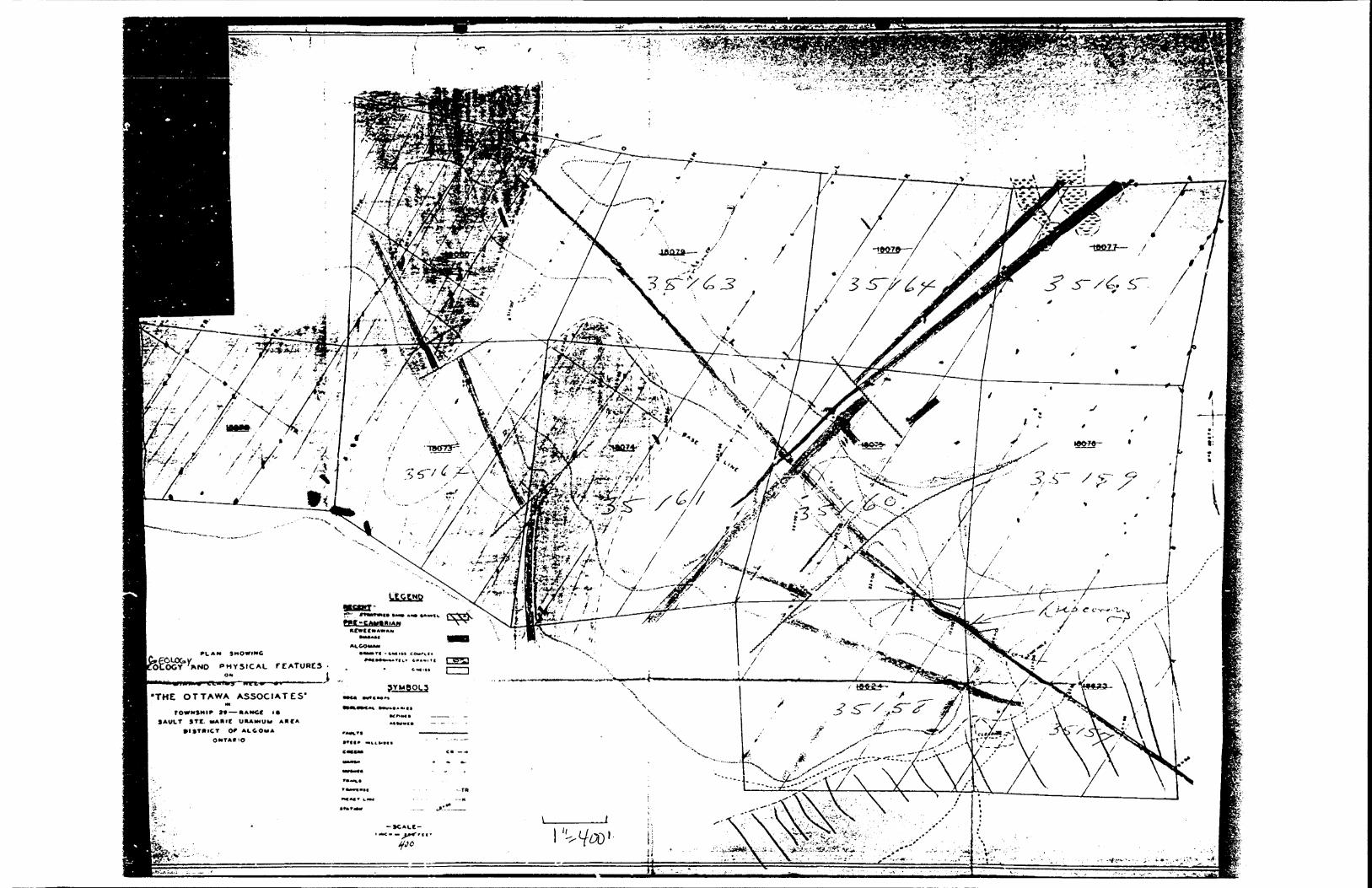
Tho rs*oporty lo cooBtitutod of 9 clains, nun^orod as
followo:
3Ci: 35157 - 35165 (9 claias)
Vl^ooo aro ror*ir. '-.crod at the ofXico of tho iiliainc Roc-
at C-iiult .-:ta. /i'-ado, A:': ^1=0 :itu.io of '"rio ^ttav^T
3oO aero s r^ro i^oiivj^utod: ;CL1 clali^D nro eontisucuo and
up a c^^^P rou^Jly o-iuaro ir;
Tlio location lioa about tiQ riiloo north of Sault Sto.
ISario, on t to north oh ore at the coot on d of lato Superior*
The Agawa Rlvor flowo fron tho oast, paosing g nilo oouth of
the oouth property boundary and tho nouth of tha Hoatroal
Page 2*
River lias about 12 nilas south from hore.
Easiest accooo io currontly by Algoca Central Railway
Iron the "Soo" to oilu lOM from hero a tote or truck road
9000 fivo nlloo in length goes to tho boundary of tho property
on tho ahoro of Lake Superior*
At tho present tioo tho Trans Canada Highway fron tho
Soo has boon completed to tho Agawa River, i nilo from tho
property, but this hao yet to bo bridged; it can, ho/over, bo
forded in a 4-whool drive truck, and ao it io pooniblo to drive
directly to tho property froa Sault Ste, I brio*
Altoraativoly, aircraft can bo chartered at Sault Ste.
liario and c&i fly directly to tho property.
111-, Dud Ccxsk opcratos a Tourist LCK'.QO f cor fio^dng
portiQO'.thio lodco is at tho oouth of tho Agawa River, 20
ninutoo walk from the property.
JII3TOHY OF T?iS PRO.P.EOT
The property wao originally stated by a proopeotor in
19*t9 and la tor acquired by tho Ottawa Assooiatas (a group of
business oon frcra Michigan, U.S.A.)
At this tino tho area had bocono of popular interest
owing to tho finding of pitchblende at Alona Bay) this find
was given groat publicity but by 1950 had foiled to satisfy
public expectations! the interest of public capital shifted
to Deavorlodca and other points, and tho area at tho oast end
of Ldka Superior (in which the Agawa River Property is situ
ated) fell xnto low repute. In 1954 tho "Ottawa Associates*
allowed tho c lemay to lapse but irsraediately re-acquirod then
by reetaking.
WORK CAjyHISD PIT? O?? ?11K C MI ̂ 70 DATS
Tite claino havo had a geological curvoy porfcraod on
then, and a geological nap of tho property hao boon completed
by J. Q, ilcCotabo, Geologist.
In ono locality only at the dincovory location of a
pitchblende voia linitod stripping has boon porforaod.
It le probable that eorao proopocting of tho area hao
b;)on undertaken, but in view of tho esctrcaoly rx^cod condition
of tho country it is likaly that thoro in roon for further
work of t hi o kind.
A hydro fKJwor otation le located at tho Montreal River,
12 :,ileo south of the* property i the coot of oxtendinc tho
trarmnieolon lino to Aca\ai iiivor would bo in tl^o vicinity of
0120,000.
Thoro io a uavt-oill at 2-iilo 104 on tho Algoaa Central
Railvayi Anple tiobor and water for all r.iininc purpooos can
bo obtained locally.
PHISIOAL CHARACTSR^STIgS OF 3.KS PROPERTY ARKA.
The country io very mountainous, with otoop hills
rising to hoiehts of TOO feet abovo Lako lovolJ in places
stopped acarpe reach to height c of 200 foot or so* OuHoyc,

Pago 4.canyon*like in character, cut the Mils in directions both
northwest and northeast.
Tho Dountain-sides, where not represented by both
flnnfllX and large ocarpe and cliff o, ore overburden covered* Tho
eanyon-liko galleys referred to usually fern the beda of the
crooks: their floor io coaraonly covered with a debris of huge
boulders carried down by mountain torrent s s only the steep
canyon wall o oro exposed*
Tho aroa has not boon burnt over for nany yoars and is
thickly wooded with epmico and hardwood tfcaber: the underbruah
la hoavy.
QBOLOGI OF Till;! ABBA
Tlve area north of Sault Ste. Marie (and for oooo distance
back froa tho share of Lako Superior) botvioon Batchauana Bay
and Hichipicoten Harbour (and north of this) is underlain by
precambrian rooks: to the oouth of this aroa, tho rocks of
Huronian ago oxtend in a strip fron Sault Ste. Marie to Sudbury.
Hoar Batchawana Bay tho ancient rocks of the Keewatin
lava o are overlain by those wuch youn^or in ago i the latter
consist of conglooeratoo and sandctono, later than the Cobalt
series in geological succession.70 niloa to the north, and for a distance of j*0 olio o
south of this point, rooks sinilar to those of tho Batchavana
Bay aroa occur.
Tho intervening area between those sections, occupying
25 or 30 niloa of the shore of Lako Superior, is underlain by

J*,
granito, granite gaei&o and fpraaitia rocks taoluding PogjoatitoD.The Agawa River property falls within this latter area
of granite gnoiea.
0/SOLOQY OF 'flUS PROPERTY
The boart deocription of the rocks underlying the property
has boon given in tho report of John O* ZfcCcabo who napped tic
claioa ecologically* Thie is directly quoted as follows:-
"Tho property lies within an area of Pre-Caobrian rocks and is
underlain and dominated by a granito-gnoi&d complex* This
conplox is ccnpoood of old altered oodinonto and intruoives
v/hich now appoor ao paracnoioooo and granite gnoiao, and are
intruded by very iriM^vil&r dikoo, sillo and tonguoo of lator
granite that varies in composition, texture and colour froa a
very corase granied white croy ty?3 to a fino craniod red
syonitio variety* Tlieso intruding granites generally tond to
take tlio f ara of narrow ;.-oughly parallel dikoo and tongues that
coincide, more a* looo, with t ha otructuro of t lie .;jtrudod hoot
rocks. Howovor, in sorao inotancos tho ,3ranit30 do talso the fora
of low dipping aillo and this adds to t bo complexity of the
ea in pattern.
On a baoio of rock outcrops oxowinod it vK)uld appear that
tho Epoosaic rocka dorainat-o the oaotorn part of tlio property
while cyanite io rfjoro prodooinate over part of the western area.
In both caoec, ao differentiated on the geologic plan, the
oonplox ie proeent but varieo insorauoh ao the ooot conmon rook
type is concerned. In tho predominately c^anlto area the
probably represents undigested fragtaonts Uiat take fc.

of Unit o d roof pendants.
Tho cranitc-gnoiso coaplox hac boen intruded by
diabaoo dikoo of two and possibly ooro a0oa. The oldest
dikoo otriko north-Y m o tor ly eouth-oaoterly and aro quartz loon
and oosily errocSed. Tho younger diko oyoton otrikos north-
ocutorly oouth-wooterly, aro quarts rich and do not orrode
oaoily, in ooao instances forsdng low ridges above tho noro
oaoily orrodod hoot rocko.
Within tho property boundaries tho older diabaooe oro
roprouontod by three nain dikes of which tho most easterly
io by far tho r.iout important ao witii it is aooociatod rich
pitchblende dnoralisation. It outcrops on clnio 35157 and
poroioto throuch to Moot of claia 35163. Hosrt/ in importance
is tho diho that outcrops near tho oouth v/ect corner of clain
35161 and porsieto tliroucU a well dofinod crook valloy, through
to v/oct of clain 35163. ?ho thia'd diloo of thio ago outcropo
on claino 3515^ and 35160 but dooo not appear to havo tho por-
oistoncy of tho other two
TliG younsor diabcx&o finds oxproosion in tv/o woll
dofinod, parallel dilcoa tlint dlsoct tho projKir^ throuch
claino 35161, 35160, 35164 and 35165.
Glacial deposition of Ploiotocono 050 is expressed in
tho glacial dobrio conpoood of unoortod boulder aatorial and
suni stratified oandti and cravolo that naok bedrock ovor con-
oiciorablo aroac.
Hocont dopooltion of stratIfiod sands and gravols is
prooont on tlw oouth oaotorn llnito of tho proporty while
roount de pool t i on of angular rook fragment o, derived froo

Page 7*
slides, fill tic acre constricted valloy bottoas and 2cva
limited talus slopes along tho lower linito of wider onoa
The structure is coaplcx. Tho granites and gneisses
which forn the granite-noiss complox lie along the northern
litab of a wide truncated anticline. They strike roughly oast
and west and dip into the north 300 - 45O * Conaiderablo
faulting occurred in tho ocaplex previous to tho intrusion of
tho diabaooo which intruded thensolvos along those conoo of
rock displacement. Those faults appear to have boon nornal
faults end in pattern v;oro confinod to north-wostorly, south
easterly faults dipping into the north-oaot, and ncrth-
oaotorly, oouth-wosterly faults dicing -nto tho ncrth-uest*
Post diabase faulting has followed the oarao pattern as
that which occurred provious to diko intrusion* Tlw nbi',
oaotorly north-vroot striking dilco, vrtiich carries uraniua min
eralization , cufforod faulting along its hanging wall contact
and this '.vao responsible for a sono of broceiation along which
uraniuta nincralisuition deposited, and probably at tho cane
tine tho north-west striking dikes wore displaced by a series
of north-oaotorly striking faults. It is tho writ or 'a opin
ion that practically all of thu faulting occurred previous
to tho deposition of uraniua mineralisation and that it has
tended to control and legalise tho mineralised sonoo. Poet
udnorol faulting has occurred but is loos prevalent and dees
not follow tho previous set pattern* The nlnoraliaed sono la

Pogo d.
of foot eooo fifteen foot by a reverse fault that strike of
apprcocimtely east and wast end dips into tho nwth* Thio
was t bo only definite poet mineral fault that was noted**
(Hot e i Current claim nurabors havn boon inserted in place of
those of ncw-lapood claims, to which "V. McConbo refers.
T OH CLAIM SSEj 3ff 5?Tho occurrence hao boon previously roforrod to under
tho heading "Wccfe Carriod out on tho Clains to da to".
It is roaohod by a trail 25 minutes walk froo Cook* o
cabins, and lioo noro or loss at tho foot of tho mountain
to tho north of horo.
Hero a diabaoo dike (with a probable width of 60
foot or oo) r.r.rikoo ocoo H 60 W into tho high areal erodon
haa out dovm \...o diko loaving canyon \falle 60 .foot or loos
in height: tho canyon bottoea 10 boulder covered and is a
ctroaa bed. The dyko is scant ly outcropping in one locality.
Horo for Id/* foot tho northeast contact of tho dyko io
ortpoced - nost of it by nature and oono of it duo to strip
ping. To the northwest, tho dike (and both contacts) boeonos
covorod by progressively doopor overburden: to tho oouthoast
it ia ovarburdon-covorod, aloo, and ultimately (after 400
foot or oo ) projects its extrapolated extension into tho
valley of tho Agaua Rivor, and into doop ovorburdon.
Thus all that can be soon of the occurronco at present
is contained in an area 1&4 feet Ions, both ends of tho area
ovorbui-don-covered, end only tho northeast contact of the diko
exposed,

9*
Tho najor o trot c h of the otriko distance of 1& foot
of which the contact is exposed io only weakly radioactive!
the vein sone in which M.gh concentrations of uroniun nfneral-
ijjation occur lias at tho northwost ond of tho 164 ft. stripped
DOC t ion: it occupies a length of corao 20 foot or so and io
continuous to the northwest whore it bocoaos obscured by
Shallow overburden: tho latter boeorass progressively deeper,
as stated, but could for a short distance, at any rate, bo
removed by trenching.
Tho high-grade uraniun mineralisation, whore observed,
occurs at or no or tho contact of tho diabase dyke with tho
granite gneioo host rock! at this section the contact has boon
strongly sheared or f allite d on tha hansing-vrall side of tho dike,
uhich dipo to the northeast at an angle of 55 decrees In this
neighbourhood: tho dike contains breccia particles.
Tiw rock in tho oheav-sone has been hydrothenuaHy
altered, vdth introduction of hematite no a dissemination in
tho dyke for a width of JO Inches! calcite both white and ciauvo-
tingod forms an appreciable quantity of tho vein materials ninor
quantiti&s of c'dorito occupy fractures in the diabaoo. A
coarsely orystallintf quarta voin is contiguous to tho voin oono.
This identical type of quarts has not boon oeon by tha author
other than* or no or the Fold Lake Area of the Bo&vorlodgo Area*
Tho 4" voin of m o rive pitchblende and of pitchblende
distributed in small fractures along a V high grade aono io
sandwiched bo f. M on tho shear B one and the granite hanging wall*
This latter voin in all probability carries tho bulk of
•.-1-1
x
1*60 10.
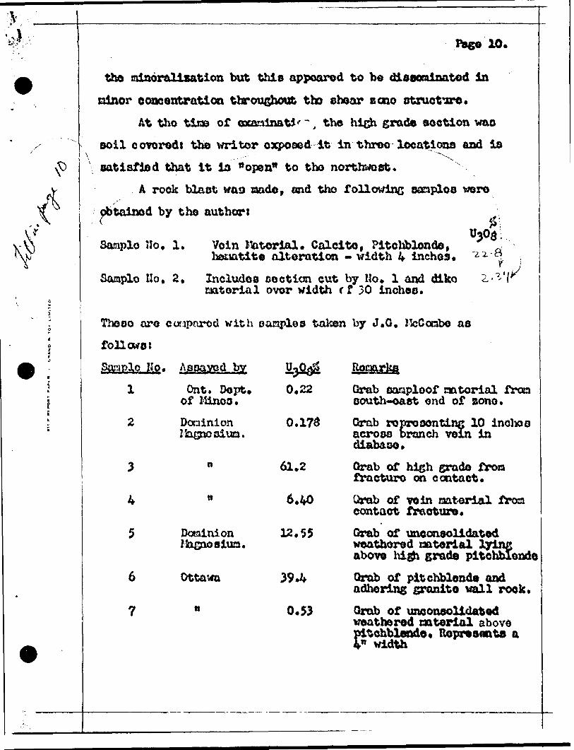
the ,tion but appeared to
ninor concentration throughout tho shear B one structure.At tho tios of cxaoinat*'", the high grade section was
soil covered! the writer exposed it in throe locations and is
satisfied that it la "open" to tho northwest.
A rook blast wag nado, and tho following sanploa were
obtained by tho authors
11303;C
Sanplo Ho. 1, Voin Material. Calcite, Pitchblonde,hociatite alteration - width k inchos.
Sanplo Ho, 2* Includes ooction cut by No* 1 and dlkomaterial ovor width r f 30 inches*
Thoso are couparod with oanples taken by J.G, KcConbe as
follows t
'^'
Sample. Nro.
l
Assayed by
Ont. Oopt* of Minos.
Doainion IJasnQsiua.
0.22
0.173
61.2
- .
4 tt 6.40
5 Dcaainion 12*55IJagoosiua.
6 Ottawa 39*4
7 " 0.53
Romrkq
Qrab sanploof natorial frcsa oouth-oaet ond of zono*
Qrab roPTOsonting 10 inohoo across branch vein in diabase.
Grab of high grade fron fracture on contact.
Qrab of vein natorial Jtrom contact fracture*
Grab of uneonsolidated weathered material lying above high grade pitchblende
Qrab of pitchblende and adhering granite wall rook.
Grab of uneonsolidated weathered oaterial above Pitchblende* Ilopresenta a
n width
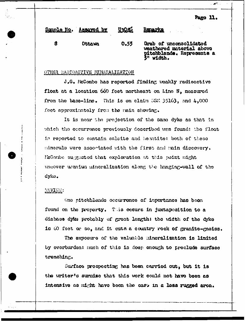
n.Stopple No. Assayed by
Ottawa 0,55 Grab of uneonoolidatod weathered aatorlal abovo pitchblende. Represents a 5" width.
PTKSfl U ADIOACTIVH i
J. O, McCotabo has reported finding vwakly radioactive
float at a location 66O feet northeast on Lino N t cioaourod
froa tho baco-linc. Thlc io on clatn :;iXM 35163, r,nd 4,000
foot ftpproxirantoly frcr^ t ho noin sljov/ins.
It ic nonr t ho projoctiwi of tho Dar.io dyko ao that in
vrhich tho occurronce proviouoly doocribod vmo found: tho float
if* roported to cor.tain calcite and ho.iatito: both of thooo
;;inorals wore aaoo^iatod vdth tho first arid riain diocovory.
HcCrsribc su/^otstod that exploration nt t.xls jxilnt uicht
liTicovor lu-anixuu uincralication along t'r?c Inncing-wall of tho
dyko.
pitchblendo occunrtmco of inportanco haD boon
found on the property. T .io occurs in juxtaposition to a
diabaoo dyto probably of groat length) tho v/idth of tho dyko
io 60 foot or oo, and it cutn a country rock of granito-cnoios,
Tho expoouro of tho valunblo .Jdncralication io liaited
by ovorburdon* tmch of thio in doop oiiouch to preclude surface
trencliing.
Outface prospect ins ^o boon carriod out, but it is
tta \Aritor'o ouroiao that thio work could not have boon as
intensive aa might have been the ca0'* in a loss rugged aroa.
Page 12*
As part of a largo r and nor o extensive occurrence, tho
Main Showing on claln S8M 35157 would certainly roprosont an
ore-shoot.
It can bo ohovn by simple arithmetical calculation that
a pitchblende vein grading 12. 4?* t^Og per Ton acrooo a tfidth
of l inch vdll dilute to a grade of ^50/ton whon takon over a
width of 3 foot,or ctinins width* i'or this calculation uraniun
oxide (U30g) i'* priced at S7.257lb,
in th*) case o! tho ohovins c'.oocribad, tho oanplo cut
gave an asoay of 22,8^ U^O^ over 4 inchoo: i5aa?lo Ho, 2 (talcon
in tho oaruo pit, but including dyko raatorial) aosayod 2.3^
ovor a v;idto of 30 inchoa.
Ovor o width of 36 inchoo, tho nrados can bo calculated
ac diluting roapoctively to 2.5/' and l .9/5 ^303.
At 07.25/lb. tho avcraao valuo (2^2jS U^Ojj) calculatod
fro:a tlio abovo oha/c a value of v319.W o^/or 3.0 foot.
i'1',0 foro^inf: io a^o^m in orUor tt^ o:nphaaiso that hich-
grado pitchblondo, ovon ovor narrow x/idtho, can produce a vory
yood crndo of oro. It can bc oontionod hore, and it io gonor-
a3.1y lcnotn^ that pricoo in c::couo of v?.25Xlb. UjOij nay bo
arrc,r4.;od by special contracto with Eldorado Kinins and P.ofinins
Corapany, the Crown purdiaoinc a^ento for uraniun in Canada.
V/hotJior or not t ho required "larger and nore extensive
occurrence", i^ontioned alove, can bo developed rociains to be
proven by further exploration.
In the case of Carsray and Hanwick Uraniuo Mines Idtoitod
Pago 13*
com;ani*a explored thoir occurrences (which wore sooouhat
similar in nature to that which is the suljoct of this roport)
by our face drilling and by underground dovvlupoor.t. They
;mdortook this work at a tino when tho only knovm raotbod In the
oro-droooins of pitohblondo wao by gravity troatnontt (this
typo of treatnxmt givoo a rocovory of 70S* approodUaatoly, and
has now boon roplocod by lor chine processes, which sivo a vory
high rocovory). At thia tira the prieo paid fer uranium uao
02.75 POT Ib* of U30g dolivo:*c*d at tlio railtoad ao a concon-
trato of nou loso than lOJ* "^303.
Sinco tlion tho toclinolof^ of tho dovolopaont and
trtatoont of uraniua oro o L*ao advanced and tho price paid for
the product hae Incroaaad conaidorably. All the work porfomcd
in 4.950 and prior to thin dato raust bo cctisidorod as new
subject to reatsoooaont,
r roppocting ef tho property ahould :ontinuo t and if
poooJblo an inoontivo for the diccovery of now mineralisation
should bo givou to t ho proapootor.
Tho pain aliowins should bo stripped to its northwootorn
limit oa* to tho point at wJiich it is no longer posoiblo to
carry out this work duo to depth of owrburdeni at tho oano
tJjQQ oxploraticn crooo-tronching stould bo carried out whenever
Uiio is possible m^d beyond tlio limits of tho knoua eoction of
value t this In 1 1 or roconaondation may bo difiioult^o follow,
since tlio extensions of tho diabcoo dyko uith which t-)o minor*
alication is associated appear to bo generously covered with
sand, boulders and gravel*
Pago 14*
A aiaall conproasor (105 c.f *n*) should bo tckon to ths
main ehovring and rock pitting should bo un^ertakoni the purpose
of thia vill priraarily bo to invootigatJ tho voz-tical contin
uity of tho oro-ohoot; in ito porfoznonco, howavor, this rock-
pit or "opon-cut undorhand otopo* will cortaialy dovolop
brokon rock rich in uranium which will bocosto valuable at tho
tiao tliat tho Midway traverses tho propertyi an effort ehould
bo mado to raino tldo soloctdvoly.
In nny developoont to bo undortakon of tMu naia sha/inc,
ovory offort ol^ould bo mdo to kcop olooo to tho aono of voluos
nuch ao io tho practice in tho nining of silver veins in Cobalt
and in tho ttUcon.
An expenditure of up to 330,000 io rooonzaondod and this
lo x/arranted by tiio poooibility or a successful dovolopnont
of tho pitchblende shov/ing on claia SSK 35157.
Toronto, Ontario, 10th Juno, 1955.
Rospoctfully Suboittod,
J* H* Macdonald, B.So^, P* Engt

I-ilAY ASSAY LABORATORIES LIMITED,
ASSAY CSRTIH&VB
To: Mr. J. R* Ihcdorudd,25 Adelaide Stroot West, Soon 206, TOilGHTO, Ontario.
nocoivod Juno 7i 1955* REPORT HOJ 861.
Sanp?.o No. Lab. Ho.
Agawa R. Prop n it tt 2.37
Juno 7/55. Certified b/ 3*J* Brooker.

MAP SHOWING LOCATION Of
IN
TOWN3MIP3 281 28 —BANCe AGAWA RlVCR-FRATER URANIUM AREA
OI3THICT or ALGOMA ONTARIO
*LAM JHOWIHC
PHYSICAL TCATURCS
OTTAWA ASSOCIATES'
a* — KAHCC i*1AULT STE. HARK UltAIHUW **CA
• I*T*ICT O' ALCOHA
OHTAtlO