murdoch activity centre main street and mixed use precinct
TRANSCRIPT
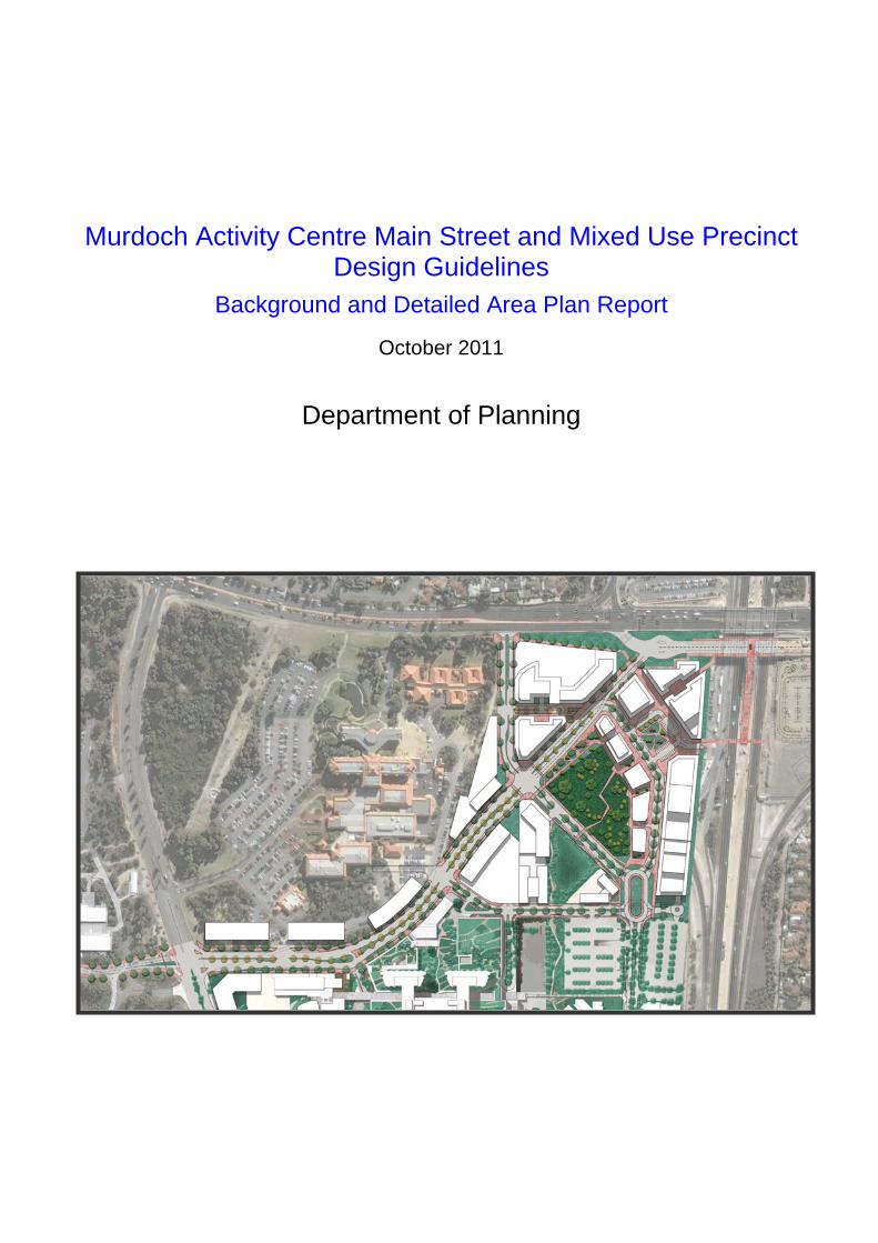
Murdoch Activity Centre Main Street and Mixed Use Precinct Design Guidelines
Background and Detailed Area Plan Report
October 2011
Department of Planning
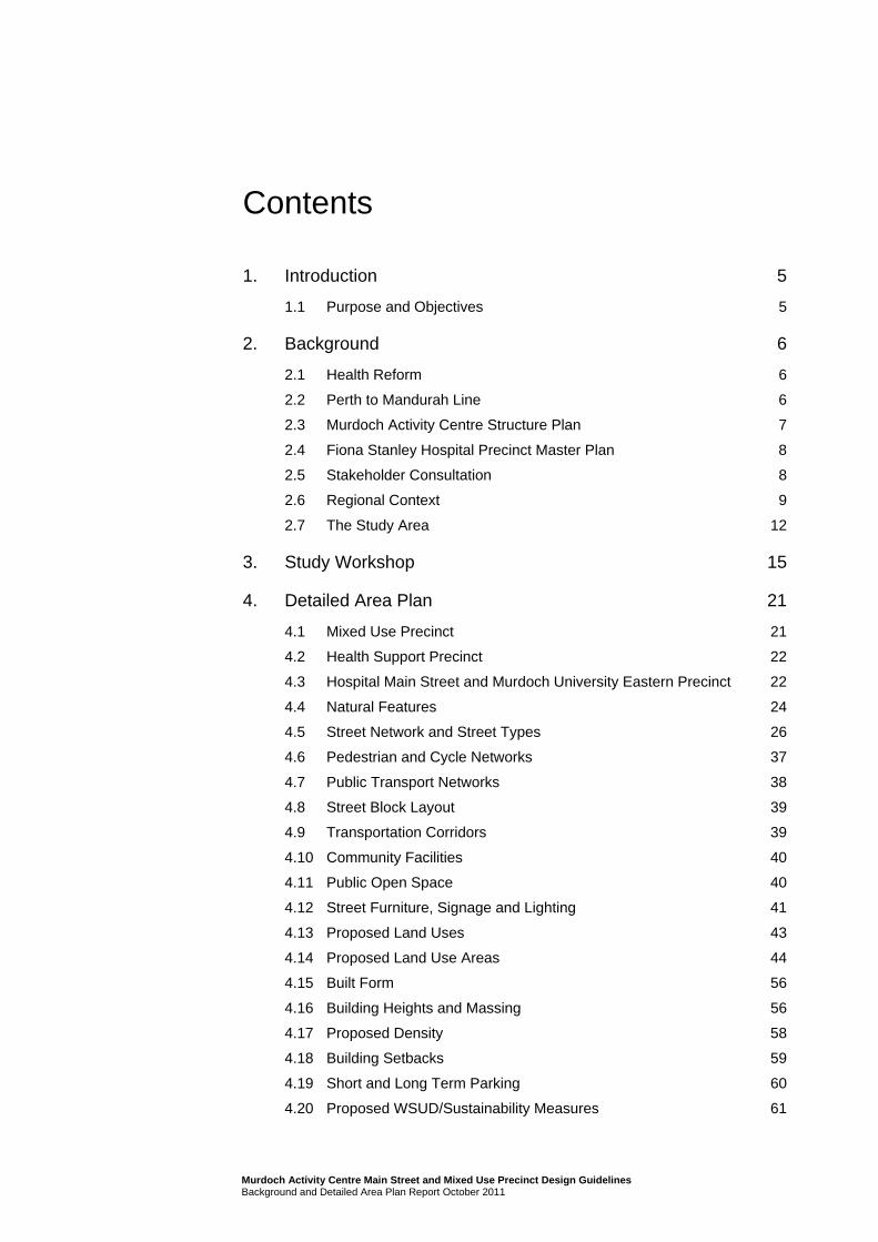
Contents
1. Introduction 5
1.1 Purpose and Objectives 5
2. Background 6
2.1 Health Reform 6
2.2 Perth to Mandurah Line 6
2.3 Murdoch Activity Centre Structure Plan 7
2.4 Fiona Stanley Hospital Precinct Master Plan 8
2.5 Stakeholder Consultation 8
2.6 Regional Context 9
2.7 The Study Area 12
3. Study Workshop 15
4. Detailed Area Plan 21
4.1 Mixed Use Precinct 21
4.2 Health Support Precinct 22
4.3 Hospital Main Street and Murdoch University Eastern Precinct 22
4.4 Natural Features 24
4.5 Street Network and Street Types 26
4.6 Pedestrian and Cycle Networks 37
4.7 Public Transport Networks 38
4.8 Street Block Layout 39
4.9 Transportation Corridors 39
4.10 Community Facilities 40
4.11 Public Open Space 40
4.12 Street Furniture, Signage and Lighting 41
4.13 Proposed Land Uses 43
4.14 Proposed Land Use Areas 44
4.15 Built Form 56
4.16 Building Heights and Massing 56
4.17 Proposed Density 58
4.18 Building Setbacks 59
4.19 Short and Long Term Parking 60
4.20 Proposed WSUD/Sustainability Measures 61
Murdoch Activity Centre Main Street and Mixed Use Precinct Design Guidelines Background and Detailed Area Plan Report October 2011

5. Proposed Staging of Development 62
Figure Index Figure 1 Regional Context 10
Figure 2 Local Location 11
Figure 3 The Study Area 12
Figure 4 Study Area Precincts 13
Figure 5 Mixed Use Precinct Preferred Design 17
Figure 6 Murdoch Activity Centre Mixed Use Precinct and Main Street Preferred Design 20
Figure 7 Mixed Use Precinct Areas 21
Figure 8 Health Support Precinct 22
Figure 9 Hospital Main Street and Murdoch University Eastern Precinct 23
Figure 10 Conservation Area 24
Figure 11 Street Network 26
Figure 12 Mixed Use Precinct Road Layout 27
Figure 13 Main Street Cross Section - Mixed Use Precinct 28
Figure 14 Main Street (Hospital and Health Precinct) Cross Section Plan 29
Figure 15 Main Street Cross Section A 30
Figure 16 Example of Cross Section A 30
Figure 17 Main Street Cross Section B 31
Figure 18 Main Street Cross Section C 32
Figure 19 Mixed Use Precinct Road Cross Section 33
Figure 20 Road 6 Cross Section 34
Figure 21 Service Road Cross Section 36
Figure 22 Precinct Treatments 42
Figure 23 Mixed Use Precinct A 45
Figure 24 Mixed Use Precinct B 47
Figure 25 Mixed Use Precinct C 49
Figure 26 Mixed Use Precinct Area D 51
Figure 27 Health Support Area 53
Figure 28 Hospital Main Street 54
Figure 29 Murdoch University Eastern Precinct 55
Figure 30 Building Heights 57
Figure 31 Mixed Use Precinct Bulk and Scale 58
Figure 32 Short Term Car Parking in the Mixed Use Precinct 60
Murdoch Activity Centre Main Street and Mixed Use Precinct Design Guidelines Background and Detailed Area Plan Report October 2011
Murdoch Activity Centre Main Street and Mixed Use Precinct Design Guidelines Background and Detailed Area Plan Report October 2011
Appendices A Murdoch Activity Centre Structure Plan
B Stakeholder Workshop Outcomes Report
C WAPC Murdoch Activity Centre Interim Access and Parking Policy 2011
1. Introduction
This study proposes to build on the background planning and consultation work and recommend land use and design scenarios for the Main Street and Mixed Use Precinct of the Murdoch Activity Centre.
The study area forms part of the Murdoch Activity Centre Structure Plan Part A area, located at Murdoch in the south metropolitan Local Government area of the City of Melville adjacent to the Murdoch Railway Station on the Mandurah Line.
1.1 Purpose and Objectives
The purpose of this study is to investigate and identify a preferred land use and design option for the study area, and then to develop a Detailed Area Plan and Design Guidelines for the Main Street and Mixed Use Precinct.
This report represents the supporting material to the Detailed Area Plan and sets out the principles which will underpin the Design Guidelines.
5 Murdoch Activity Centre Main Street and Mixed Use Precinct Design Guidelines Background and Detailed Area Plan Report

2. Background
2.1 Health Reform
In 2003 the State Government appointed the Health Reform Implementation Committee (HRIC) to
develop a vision for the Western Australian health system while ensuring that the growth of the health budget was sustainable. The Reid Report was subsequently released in 2004 outlining the HRIC findings following its review of the existing health system.
One of the key recommendations was to reconfigure the State’s existing health system over the next 10 to 15 years in a systematic and integrated way. Part of this fundamental reconfiguration, was the adoption of a north/south of the river model for the Perth Metropolitan region, identifying in particular the
need for the designation of a northern tertiary hospital at Charles Gairdner and a southern tertiary hospital (Fiona Stanley Hospital) at Murdoch.
2.1.1 Fiona Stanley Hospital and Health Precinct
The Fiona Stanley Hospital and Health Precinct is integral to the total rebuild of Western Australia’s
health system and an important step towards its improved safety, sustainability and efficiency.
At the completion of Stage 1 the hospital will provide a range of acute medical and surgical services, and be the home of Western Australia’s major centre for treatment of trauma, burns, and heart and lung
transplants. It will also include:
(a) the State’s first comprehensive cancer services south of the river including radiotherapy treatment facilities, medical oncology and haematology;
(b) renal transplantation and dialysis;
(c) paediatric services;
(d) a full array of tertiary medical and surgical services;
(e) extensive radiology services including MRI, CT and PET/CT; and
(f) a state-of-the-art medical research facility to be built by the Western Australian Institute for Medical Research.
The Fiona Stanley Hospital will ultimately be the only tertiary hospital for residents in the southern metropolitan area; housing relocated tertiary services from Royal Perth Hospital and Fremantle Hospital.
2.2 Perth to Mandurah Line
The Mandurah Line (formerly known as the Southern Suburbs Railway) runs from Perth to Mandurah and was opened on Sunday 23 December, 2007.
The Line comprises 72 route kilometres of railway, 774m of tunnels under the Perth CBD, 20 bridges and structures and 11 stations, including the Murdoch Station.
Projections showed more than 50,000 boardings each day along the Line, proposing to take almost
21,000 cars off the Freeway. However, patronage on Line has already exceeded by more than 40 per cent the numbers forecast for overall usage of the Line.
6 Murdoch Activity Centre Main Street and Mixed Use Precinct Design Guidelines Background and Detailed Area Plan Report

The new Line is carrying between two and three times as many passengers as the average 16,000
people who rode the buses along the same route, and patronage at the Murdoch Station is 127% above predicted numbers. Additionally, approximately 60% of passengers at Murdoch arrive via a bus link.
The Mandurah Line and associated public transport node at Murdoch support a growing precinct, both
for business and urban needs, and the health and education uses proposed for the area provide a strong anchor for development in this area.
2.3 Murdoch Activity Centre Structure Plan
The Murdoch Activity Centre Structure Plan – Part A (MACSP) was prepared jointly by the former Department For Planning and Infrastructure and the Department of Health (DoH) in full consultation with
the City of Melville and other major stakeholders. The structure plan map is attached to this report at Appendix A and a full copy of the text and attachments can be found on the Western Australian Planning Commission website. The Western Australian Planning Commission (WAPC) approved the
MACSP in January 2007.
The primary goal of the MACSP Part A was to provide a framework for future development of the structure plan area, which includes the development site for the Fiona Stanley Hospital (see Section
2.1.1). The structure plan identified a range of general land uses within the area whilst remaining flexible enough to incorporate a range of uses anticipated. Further structure planning of areas adjacent to the MACSP has now commenced.
The Mixed Use Precinct of the Murdoch Activity Centre (MAC) is located in the northeast corner of the site, in the south west quadrant of the intersection of South Street and the Kwinana Freeway. An urban design exercise was undertaken in July 2007 to look at future development of the Mixed Use Precinct
and Main Street. A range of objectives were identified, including:
A visual connection from the Main Street to the railway station pedestrian entrance via the Town Square must be established;
The Town Square is expected to provide for private vehicle drop-off and taxi ranks together with short term on-street parking;
The Town Square is to be ‘framed’ by buildings and active edges of all sides;
The Town Square will be designed with no kerbs to facilitate universal access and provide all amenities expected in a civic place (seats, shelter, landscape features, public art etc);
Public alfresco areas could take advantage of the southern side with the possible introduction of colonnades;
Provision for a public car park should be made beneath the Town Square; and
The secondary future pedestrian access to the railway station should also be connected to the Town
Square.
The Detailed Area Plan and Design Guidelines developed in this report reflect these objectives, as well
as the objectives developed through subsequent consultation and external design exercises for the Fiona Stanley Hospital, St John of God Hospital and Murdoch University.
7 Murdoch Activity Centre Main Street and Mixed Use Precinct Design Guidelines Background and Detailed Area Plan Report

2.4 Fiona Stanley Hospital Precinct Master Plan
The Precinct Master Plan for the hospital is intended to provide the planning and urban design
framework for the delivery of health services within a fully integrated and mixed use environment and has been developed through an extensive consultation process with hospital end user groups and stakeholders.
The aim of the Precinct Master Plan is to ensure that the Hospital Precinct is a key destination within the Main Street and Mixed Use Precinct. The Precinct planning is based on a long term view that the Main Street and Mixed Use Precinct will develop into a key regional location, serving a board range of the
community needs.
The Precinct Master Plan informs and is informed by the activities in the balance of the Main Street and Mixed Use Precinct area, and detailed design of the primary roads and building design for the Hospital
has already occurred.
2.5 Stakeholder Consultation
Consultation to date has been extensive and has included:
MACSP consultation
The consultation process for the MACSP sought involvement with, among others; key adjoining
stakeholders, local government and government agencies, landowners, the local community and indigenous groups. The process commenced with a workshop in June 2005 with all key stakeholders invited. A committee of technical officers from the various key stakeholders continued to meet
throughout the preparation and consultation stages of the plan. Key landowners including Murdoch University, St John of God Hospital, WA Police Service and the Department of Education and Training have also been consulted on a regular basis.
A 10-week public comment period followed the release of the MACSP Part A in August 2006, resulting in 84 submissions. In addition, more than 160 direct contacts were made by phone or email and over 250 people attended briefings and presentations.
Agency consultation
A number of key stakeholders have been involved on a regular and ongoing basis from agencies such as the former Department for Planning and Infrastructure, Department of Education and Training, Public
Transport Authority, Main Roads WA and others.
Other key stakeholder consultation
Regular consultation and communication with other key stakeholders is ongoing via meetings,
presentations, and dedicated freecall 1800 phone and email feedback facilities. These stakeholders include, but are not limited to:
– Site neighbours;
– Local government, in particular, the City of Melville;
– Environment groups;
– Indigenous Australians;
– The local community – including residents and community groups; and
8 Murdoch Activity Centre Main Street and Mixed Use Precinct Design Guidelines Background and Detailed Area Plan Report

– The general public.
Consultation as part of this Study
A key stakeholder workshop has been undertaken as part of this study. Outcomes of that Workshop are discussed in Section 3 of this document.
2.6 Regional Context
The Main Street and Mixed Use Precinct is located within the City of Melville approximately 15 kms south
of the Perth CBD, approximately 9 kms east of Fremantle and three kms from the nearest major retail centre and commercial area.
Figure 1 illustrates the regional location of the Main Street and Mixed Use Precinct area, whilst Figure 2
provides a more detailed local illustration of the area.
Consistent with the objectives of the MACSP, the Main Street and Mixed Use Precinct will be serviced extensively by existing public transport links, cycle ways and pedestrian pathways. The Precinct will be
serviced by the new Murdoch train station, developed as part of the recently completed Mandurah Line. The rail station links with the existing major bus interchange at South Street are integral to the activity of the precinct.
9 Murdoch Activity Centre Main Street and Mixed Use Precinct Design Guidelines Background and Detailed Area Plan Report
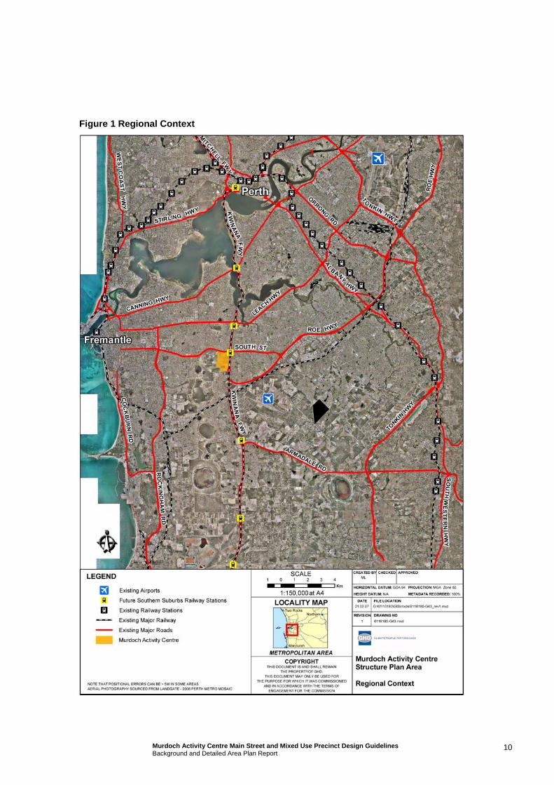
Figure 1 Regional Context
10 Murdoch Activity Centre Main Street and Mixed Use Precinct Design Guidelines Background and Detailed Area Plan Report
Figure 2 Local Location
11 Murdoch Activity Centre Main Street and Mixed Use Precinct Design Guidelines Background and Detailed Area Plan Report
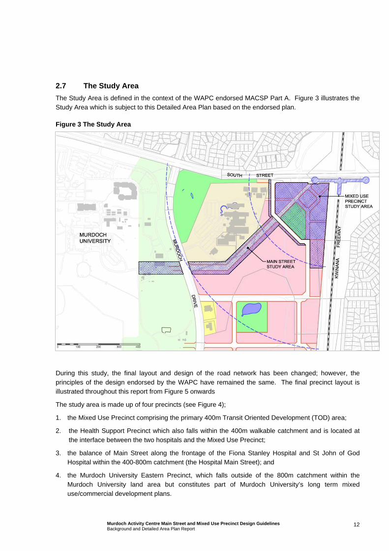
2.7 The Study Area
The Study Area is defined in the context of the WAPC endorsed MACSP Part A. Figure 3 illustrates the
Study Area which is subject to this Detailed Area Plan based on the endorsed plan.
Figure 3 The Study Area
During this study, the final layout and design of the road network has been changed; however, the
principles of the design endorsed by the WAPC have remained the same. The final precinct layout is illustrated throughout this report from Figure 5 onwards
The study area is made up of four precincts (see Figure 4);
1. the Mixed Use Precinct comprising the primary 400m Transit Oriented Development (TOD) area;
2. the Health Support Precinct which also falls within the 400m walkable catchment and is located at the interface between the two hospitals and the Mixed Use Precinct;
3. the balance of Main Street along the frontage of the Fiona Stanley Hospital and St John of God Hospital within the 400-800m catchment (the Hospital Main Street); and
4. the Murdoch University Eastern Precinct, which falls outside of the 800m catchment within the
Murdoch University land area but constitutes part of Murdoch University’s long term mixed use/commercial development plans.
12 Murdoch Activity Centre Main Street and Mixed Use Precinct Design Guidelines Background and Detailed Area Plan Report
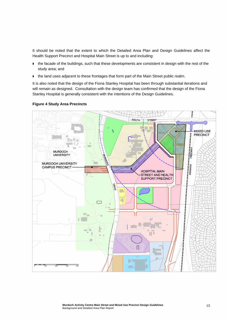
It should be noted that the extent to which the Detailed Area Plan and Design Guidelines affect the
Health Support Precinct and Hospital Main Street is up to and including:
the facade of the buildings, such that these developments are consistent in design with the rest of the study area; and
the land uses adjacent to these frontages that form part of the Main Street public realm.
It is also noted that the design of the Fiona Stanley Hospital has been through substantial iterations and will remain as designed. Consultation with the design team has confirmed that the design of the Fiona Stanley Hospital is generally consistent with the intentions of the Design Guidelines.
Figure 4 Study Area Precincts
13 Murdoch Activity Centre Main Street and Mixed Use Precinct Design Guidelines Background and Detailed Area Plan Report
Except for within the Mixed Use Precinct, this Detailed Area Plan and the subsequent Design Guidelines
consider design principles and recommendations only for the frontages of the properties of Main Street, ‘Road 6’ and in a limited capacity on Discovery Way in the Murdoch University Eastern Precinct.
The Precincts have been identified as areas where land uses are likely to be predisposed (due to market
forces and landowners expectations) to certain land uses more so than others or where certain land uses are more appropriate than others. There is, however, a great deal of crossover.
14 Murdoch Activity Centre Main Street and Mixed Use Precinct Design Guidelines Background and Detailed Area Plan Report

3. Study Workshop
As part of this study a workshop was held with attendees from all major stakeholders to the precinct including;
– Former Department for Planning and Infrastructure;
– City of Melville;
– Main Roads WA;
– Public Transport Authority;
– Fiona Stanley Hospital (Department of Health/Department of Housing and Works;
– Murdoch University;
– St John of God Hospital;
– Department of Education and Training; and
– LandCorp
Other invitees included the City of Cockburn, the Murdoch Medical Clinic and the Department of Agriculture and Food WA.
Prior to this workshop, meetings were also held with the following parties to discuss preliminary
expectations;
– Former Department for Planning and Infrastructure;
– City of Melville;
– Main Roads WA;
– Public Transport Authority;
– Fiona Stanley Hospital;
– Murdoch University;
– St John of God Hospital; and
– LandCorp.
The purpose of the workshop was to look at various options for the design of the precinct, focusing on the Mixed Use Precinct as an area within the study area that required urgent resolving.
The outcomes report from the workshop is attached in full at Appendix B to this document; however, the general expectations of the stakeholders for the study area that were communicated at the workshop were;
– Location and form of parking for businesses in the precinct is important.
– A pedestrian friendly environment.
– Ensuring synergy between the various design guidelines that will be created.
15 Murdoch Activity Centre Main Street and Mixed Use Precinct Design Guidelines Background and Detailed Area Plan Report

– Contribute to sense of public safety. Ensure high levels of take-up and activation at the street level.
– Include measures to avoid anti-social behaviour and visually unattractive areas.
– Ensure the solution can be sustained by the market (commercial viability).
– Ensure target mode splits are achieved with minimal congestion with the bus link open at the
opening of the hospital.
– Ensuring continuous access to car parking for Park ’n’ Ride users – origin and destination.
– Multi purpose facility for community use by City of Melville.
– TOD must be fully integrated with surrounding road links – South St and other.
– Street parking along Main Street should be included into the design.
– TOD must fit within the broader context.
– Student accommodation within the area and MU expectations for this site.
– Not part of this study area but need to have activation and transport links extending to the TAFE site.
– Control of pedestrian access through sensitive and remnant bushland – encourage links along roads.
– Urban design and built form must integrate with landscape character.
As a result of the outcomes of the workshop, and the general comments received subsequent to the
workshop, Figure 5 represents the preferred design option for the Mixed Use Precinct, shown in stages as follows:
– Bus Lanes;
– Pedestrian Network;
– Road network;
– Soft landscape; and
– Built Form/Trees.
16 Murdoch Activity Centre Main Street and Mixed Use Precinct Design Guidelines Background and Detailed Area Plan Report
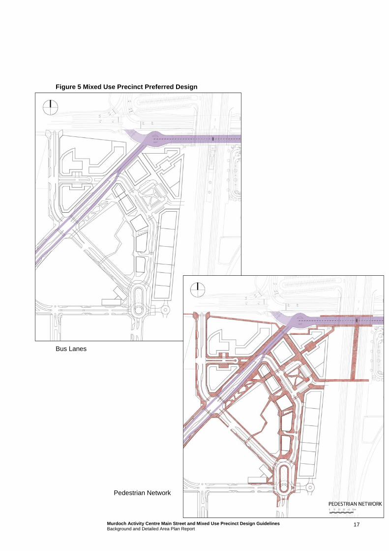
Figure 5 Mixed Use Precinct Preferred Design
Bus Lanes
Pedestrian Network
17 Murdoch Activity Centre Main Street and Mixed Use Precinct Design Guidelines Background and Detailed Area Plan Report
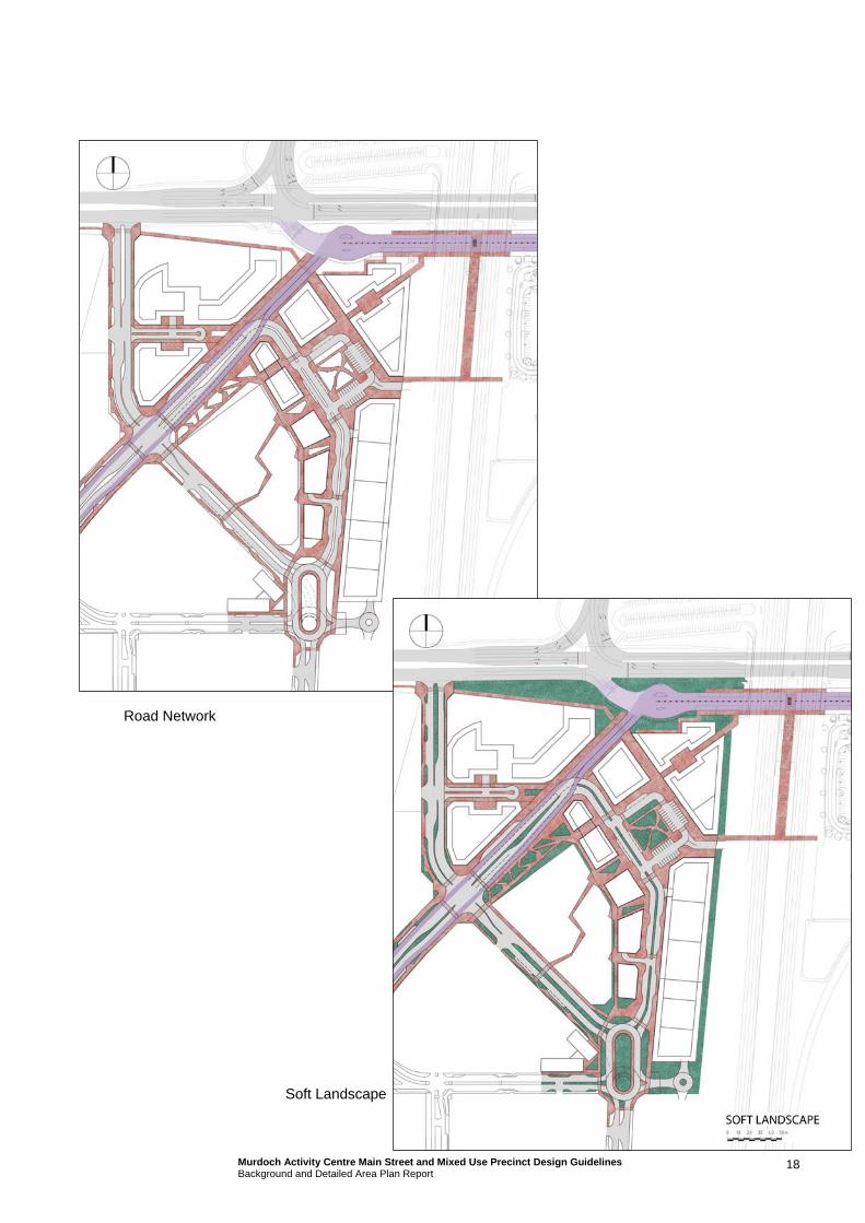
Road Network
Soft Landscape
18 Murdoch Activity Centre Main Street and Mixed Use Precinct Design Guidelines Background and Detailed Area Plan Report

19 Murdoch Activity Centre Main Street and Mixed Use Precinct Design Guidelines Background and Detailed Area Plan Report
Built Form/Trees
The preferred design option for the Mixed Use Precinct, integrated with the proposed designs of the
Fiona Stanley Hospital, St John of God Hospital and developments within the Murdoch University Eastern Precinct is illustrated in Figure 6.
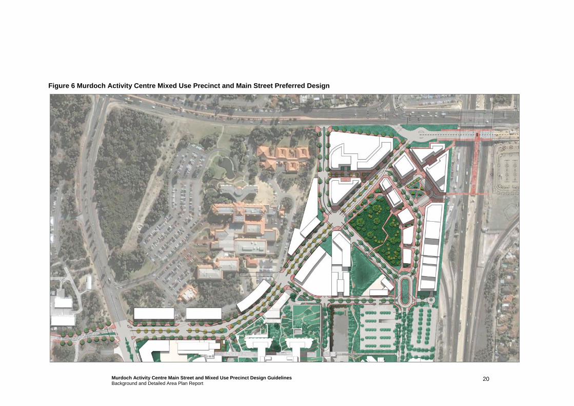
Figure 6 Murdoch Activity Centre Mixed Use Precinct and Main Street Preferred Design
20 Murdoch Activity Centre Main Street and Mixed Use Precinct Design Guidelines Background and Detailed Area Plan Report
4. Detailed Area Plan
4.1 Mixed Use Precinct
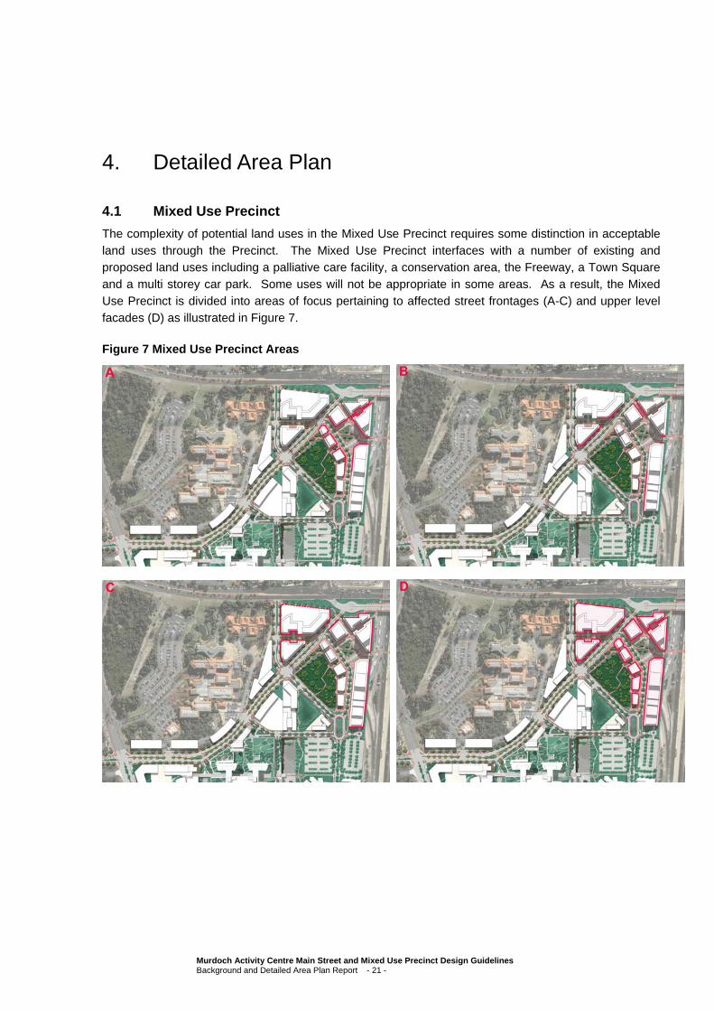
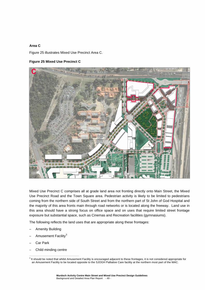
The complexity of potential land uses in the Mixed Use Precinct requires some distinction in acceptable
land uses through the Precinct. The Mixed Use Precinct interfaces with a number of existing and proposed land uses including a palliative care facility, a conservation area, the Freeway, a Town Square and a multi storey car park. Some uses will not be appropriate in some areas. As a result, the Mixed
Use Precinct is divided into areas of focus pertaining to affected street frontages (A-C) and upper level facades (D) as illustrated in Figure 7.
Figure 7 Mixed Use Precinct Areas
Murdoch Activity Centre Main Street and Mixed Use Precinct Design Guidelines Background and Detailed Area Plan Report - 21 -
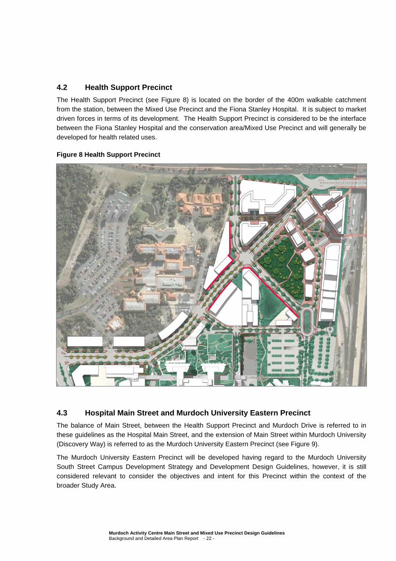
4.2 Health Support Precinct
The Health Support Precinct (see Figure 8) is located on the border of the 400m walkable catchment
from the station, between the Mixed Use Precinct and the Fiona Stanley Hospital. It is subject to market driven forces in terms of its development. The Health Support Precinct is considered to be the interface between the Fiona Stanley Hospital and the conservation area/Mixed Use Precinct and will generally be
developed for health related uses.
Figure 8 Health Support Precinct
4.3 Hospital Main Street and Murdoch University Eastern Precinct
The balance of Main Street, between the Health Support Precinct and Murdoch Drive is referred to in
these guidelines as the Hospital Main Street, and the extension of Main Street within Murdoch University (Discovery Way) is referred to as the Murdoch University Eastern Precinct (see Figure 9).
The Murdoch University Eastern Precinct will be developed having regard to the Murdoch University
South Street Campus Development Strategy and Development Design Guidelines, however, it is still considered relevant to consider the objectives and intent for this Precinct within the context of the broader Study Area.
Murdoch Activity Centre Main Street and Mixed Use Precinct Design Guidelines Background and Detailed Area Plan Report - 22 -

Figure 9 Hospital Main Street and Murdoch University Eastern Precinct
Hospital Main Street
Murdoch University Eastern Precinct
Murdoch Activity Centre Main Street and Mixed Use Precinct Design Guidelines Background and Detailed Area Plan Report - 23 -

4.4 Natural Features
A site that has been considered of high conservation value is located within the Main Street and Mixed
Use Precinct area (see Figure 10, outlined in green). The site has been assessed by both the State and the Commonwealth and it has been determined that this area will be reserved for conservation purposes in perpetuity, for feeding habitat for Carnaby’s Black cockatoo. Development surrounding this site is to
be sensitive to the site and should be designed so as not to impact on the conservation site in any way.
The conservation area will remain at its current height datum, which will be substantially lower in level than the surrounding roads and development sites in the Mixed Use Precinct.
Figure 10 Conservation Area
Development of the Mixed Use Precinct sites adjacent to the conservation area will be limited in height to support the environmental asset of the conservation area. Development of sites within the Health Support Precinct will need to consider this area also, but will generally be encouraged to be developed to
higher levels.
As a secondary benefit, this height limitation will ensure that development of sites surrounding this area will obtain views (from higher levels) to the conservation area, contributing to a sense of space in the
Main Street and Mixed Use Precinct and supporting passive surveillance of activities surrounding this large green space.
A guided pedestrian path/footbridge through the conservation area would be highly desirable, particularly
as the southeast side of the conservation area will be some five/six metres lower than the northwest side,
Murdoch Activity Centre Main Street and Mixed Use Precinct Design Guidelines Background and Detailed Area Plan Report - 24 -
but the development of this, or any other activities in the conservation area, will be subject to negotiation
with the Commonwealth Department of Environment, Water, Heritage and the Arts at a later date.
It should be noted that the Department of Health has confirmed that fencing is required around the conservation area and that this will be standard regional parks style, vertical copper log posts and cross
beam and black PVC coated chainmesh infill.
Along the road separating the Mixed Use Precinct and the Health Support Precinct a retaining wall will be constructed to retain the difference in levels; the construction of which will be standard limestone blocks
and will finish at the road level. A Traffic Study Audit of the proposed road network has been undertaken and preliminary discussions suggest that a traffic crash barrier will be required to be installed immediately beyond the kerb line along this road for the length of the conservation area.
Any fencing and/or crash barriers that occur on the boundary of the conservation area should be designed so as not to create a blank wall effect or a location for potential graffiti and should also be designed to discourage activities such as skateboarders using the retaining walls for ‘grinding’. It would
also be preferable if the design of the barriers was the same or sympathetic to the hard landscape design throughout the rest of the Mixed Use Precinct and the Fiona Stanley Hospital (i.e. consistent bollards throughout).
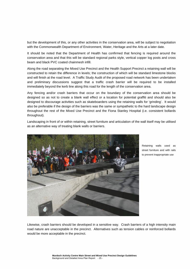
Landscaping in front of or within retaining, street furniture and articulation of the wall itself may be utilised as an alternative way of treating blank walls or barriers.
Retaining walls used as
street furniture and with rails
to prevent inappropriate use
Likewise, crash barriers should be developed in a sensitive way. Crash barriers of a high intensity main
road nature are unacceptable in the precinct. Alternatives such as tension cables or reinforced bollards would be more acceptable in the precinct.
Murdoch Activity Centre Main Street and Mixed Use Precinct Design Guidelines Background and Detailed Area Plan Report - 25 -
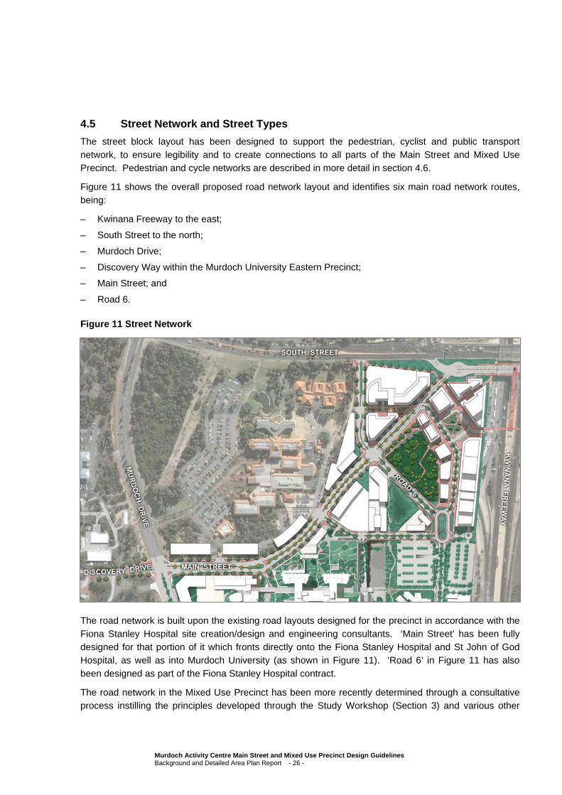
4.5 Street Network and Street Types
The street block layout has been designed to support the pedestrian, cyclist and public transport
network, to ensure legibility and to create connections to all parts of the Main Street and Mixed Use Precinct. Pedestrian and cycle networks are described in more detail in section 4.6.
Figure 11 shows the overall proposed road network layout and identifies six main road network routes,
being:
– Kwinana Freeway to the east;
– South Street to the north;
– Murdoch Drive;
– Discovery Way within the Murdoch University Eastern Precinct;
– Main Street; and
– Road 6.
Figure 11 Street Network
The road network is built upon the existing road layouts designed for the precinct in accordance with the
Fiona Stanley Hospital site creation/design and engineering consultants. ‘Main Street’ has been fully designed for that portion of it which fronts directly onto the Fiona Stanley Hospital and St John of God Hospital, as well as into Murdoch University (as shown in Figure 11). ‘Road 6’ in Figure 11 has also
been designed as part of the Fiona Stanley Hospital contract.
The road network in the Mixed Use Precinct has been more recently determined through a consultative process instilling the principles developed through the Study Workshop (Section 3) and various other
Murdoch Activity Centre Main Street and Mixed Use Precinct Design Guidelines Background and Detailed Area Plan Report - 26 -
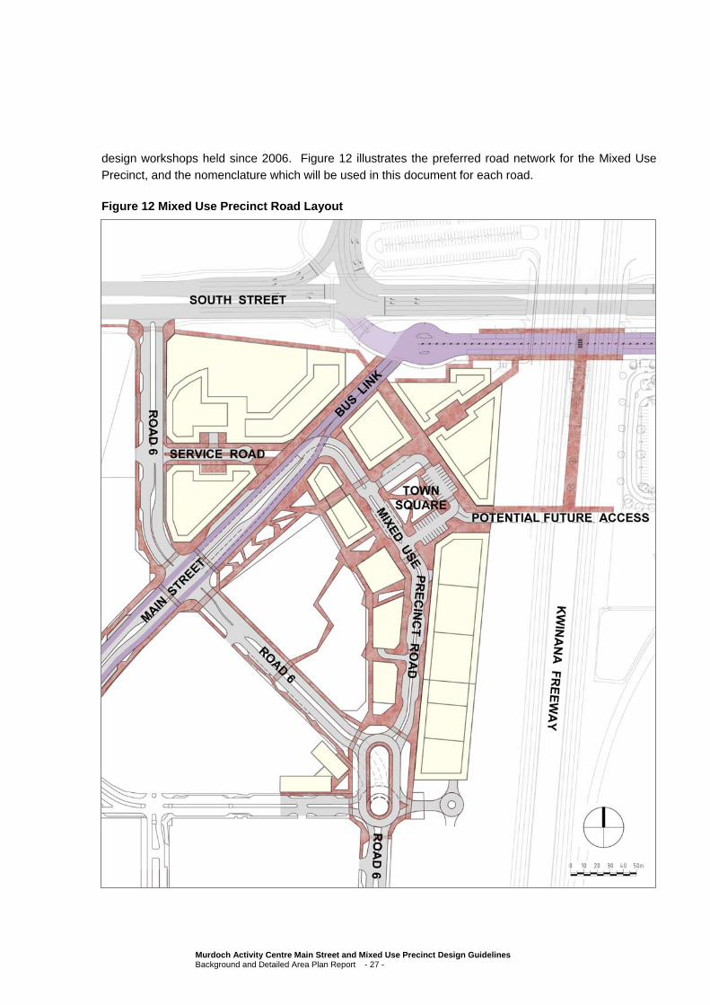
design workshops held since 2006. Figure 12 illustrates the preferred road network for the Mixed Use
Precinct, and the nomenclature which will be used in this document for each road.
Figure 12 Mixed Use Precinct Road Layout
Murdoch Activity Centre Main Street and Mixed Use Precinct Design Guidelines Background and Detailed Area Plan Report - 27 -
The following section describes the main elements of the road network.
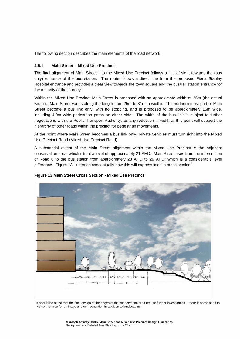
4.5.1 Main Street – Mixed Use Precinct
The final alignment of Main Street into the Mixed Use Precinct follows a line of sight towards the (bus
only) entrance of the bus station. The route follows a direct line from the proposed Fiona Stanley Hospital entrance and provides a clear view towards the town square and the bus/rail station entrance for the majority of the journey.
Within the Mixed Use Precinct Main Street is proposed with an approximate width of 25m (the actual width of Main Street varies along the length from 25m to 31m in width). The northern most part of Main Street become a bus link only, with no stopping, and is proposed to be approximately 15m wide,
including 4.0m wide pedestrian paths on either side. The width of the bus link is subject to further negotiations with the Public Transport Authority, as any reduction in width at this point will support the hierarchy of other roads within the precinct for pedestrian movements.
At the point where Main Street becomes a bus link only, private vehicles must turn right into the Mixed Use Precinct Road (Mixed Use Precinct Road).
A substantial extent of the Main Street alignment within the Mixed Use Precinct is the adjacent
conservation area, which sits at a level of approximately 21 AHD. Main Street rises from the intersection of Road 6 to the bus station from approximately 23 AHD to 29 AHD; which is a considerable level difference. Figure 13 illustrates conceptually how this will express itself in cross section1.
Figure 13 Main Street Cross Section - Mixed Use Precinct
1 It should be noted that the final design of the edges of the conservation area require further investigation – there is some need to
utlise this area for drainage and compensation in addition to landscaping.
Murdoch Activity Centre Main Street and Mixed Use Precinct Design Guidelines Background and Detailed Area Plan Report - 28 -

4.5.2 Main Street – Hospital and Health Precinct Section
The alignment of Main Street past the hospital frontages and into Murdoch University has been set as part of external design processes. The road is designed with an approximate road width of 31/32m with wide pedestrian paths and a central median.
Main Street has finished levels of between 27.5 AHD at the Main Entrance down to 23 AHD at the intersection of Road 6. These levels are lower than the existing level of the St John of God Hospital site, and the exact variance differs along the frontage; at some points up to 4 metres in difference. The intent
of Main Street is to encourage active and interactive frontages on both sides of the road, and to achieve this it is clear that development fronting Main Street from St John of God Hospital will need to be designed to incorporate split levels and alternative design solutions. A blank retaining wall along Main
Street will be unacceptable.
To best show the opportunities available for development along Main Street in this area, a set of cross sections have been illustrated, as follows (Figure 14):
Figure 14 Main Street (Hospital and Health Precinct) Cross Section Plan
At Cross Section A, the Fiona Stanley Hospital has a ground level at 27.5 AHD, whilst the existing level
on the St John of God Hospital site is approximately 31 AHD.
Murdoch Activity Centre Main Street and Mixed Use Precinct Design Guidelines Background and Detailed Area Plan Report - 29 -
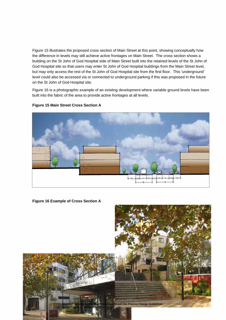
Figure 15 illustrates the proposed cross section of Main Street at this point, showing conceptually how
the difference in levels may still achieve active frontages on Main Street. The cross section shows a building on the St John of God Hospital side of Main Street built into the retained levels of the St John of God Hospital site so that users may enter St John of God Hospital buildings from the Main Street level,
but may only access the rest of the St John of God Hospital site from the first floor. This ‘underground’ level could also be accessed via or connected to underground parking if this was proposed in the future on the St John of God Hospital site.
Figure 16 is a photographic example of an existing development where variable ground levels have been built into the fabric of the area to provide active frontages at all levels.
Figure 15 Main Street Cross Section A
Figure 16 Example of Cross Section A
Murdoch Activity Centre Main Street and Mixed Use Precinct Design Guidelines Background and Detailed Area Plan Report - 30 -

At Cross Section B, the Fiona Stanley Hospital still has a ground level at 27.5 AHD, whilst the existing level on the St John of God Hospital site is approximately 30 AHD.
Figure 17 illustrates an example of a cross section of Main Street at this point. In the short term, it is unlikely that St John of God Hospital will fully develop Main Street and it has been suggested that some at grade parking may instead be developed in the short term. At grade parking along Main Street is not
desirable for the long term, but may be considered in the interim subject to appropriate landscaping and design to integrate this with the Main Street area and not detract from the visual amenity of Main Street.
The cross section shows how a parking area may be developed on Main Street in the short term utilising
a gentle slope, with a background illustration of the preferred future Main Street frontage, showing the need to again consider a change in levels from the Main Street frontage back into the St John of God Hospital site.
Figure 17 Main Street Cross Section B
Alternatively, if a gentle sloping technique is not considered, any retaining walls proposed along Main Street in the short term would need to be landscaped and developed as a landscape feature of Main Street.
At Cross Section C, the Fiona Stanley Hospital still has a ground level at 27.5 AHD and the existing level on the St John of God Hospital site is approximately 27/28 AHD. However, at this point Main Street is sloping down and is at approximately 26 AHD. At this location the difference is minor and active
frontages on both sides can be achieved with relative ease by ensuring that frontages are developed at or within 0.5m of the verge level of Main Street (see Figure 18).
Murdoch Activity Centre Main Street and Mixed Use Precinct Design Guidelines Background and Detailed Area Plan Report - 31 -

Figure 18 Main Street Cross Section C
However, further to the north east the level difference between Main Street and both the Fiona Stanley Hospital and St John of God Hospital sites again becomes quite substantial. At this point, a cross section similar to that being shown on the northern side of Main Street in Figure 15 would be appropriate.
Alternatively, new development sites may need to be excavated in some parts to better integrate with the surrounding roads (remembering also that Road 6 sits at approximately 22 AHD on the northeast border of the Fiona Stanley Hospital site).
4.5.3 Main Street – Murdoch University Eastern Precinct
Where Main Street meets Murdoch Drive and extends into the Murdoch University Eastern Precinct Main
Street becomes Discovery Way. Discovery Way is expected to have a similar width to the Hospital Main Street, or 32m, in the first instance, but is proposed to quickly reduce in width to around 28m. It should be noted that no ‘actual’ public road reserve will be created within the Murdoch University Eastern
Precinct, however, a road will be constructed and the principles of development along and adjacent to that road will remain similar and in accordance with the Murdoch University South Street Campus Development Strategy and Development Design Guidelines for that precinct.
4.5.4 Mixed Use Precinct Road (and Road 6)
The Mixed Use Precinct Road (Figure 12) follows a long direct line to the town square from Road 6 and the southern parts of the Fiona Stanley Hospital and the TAFE campus, and is proposed with an approximate width of 20m. Whilst the road alignment is not able to maintain a direct line because of
other road hierarchies within the Precinct, the line of sight has been maintained so that the visual
Murdoch Activity Centre Main Street and Mixed Use Precinct Design Guidelines Background and Detailed Area Plan Report - 32 -
connection with the town square is not lost. An elongated roundabout forms the connection between
Road 6 and the Mixed Use Precinct Road.
Both road alignments will need to be well signed to support new/irregular users, as will the Main Street and Mixed Use Precinct generally.
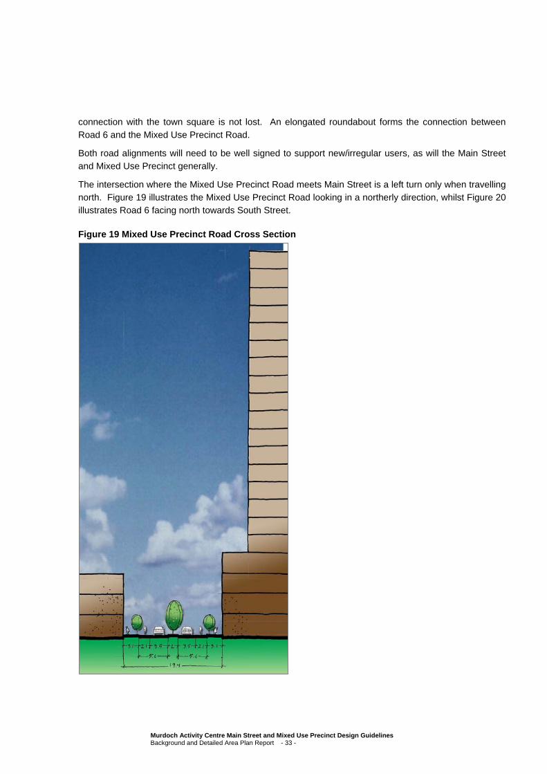
The intersection where the Mixed Use Precinct Road meets Main Street is a left turn only when travelling north. Figure 19 illustrates the Mixed Use Precinct Road looking in a northerly direction, whilst Figure 20 illustrates Road 6 facing north towards South Street.
Figure 19 Mixed Use Precinct Road Cross Section
Murdoch Activity Centre Main Street and Mixed Use Precinct Design Guidelines Background and Detailed Area Plan Report - 33 -
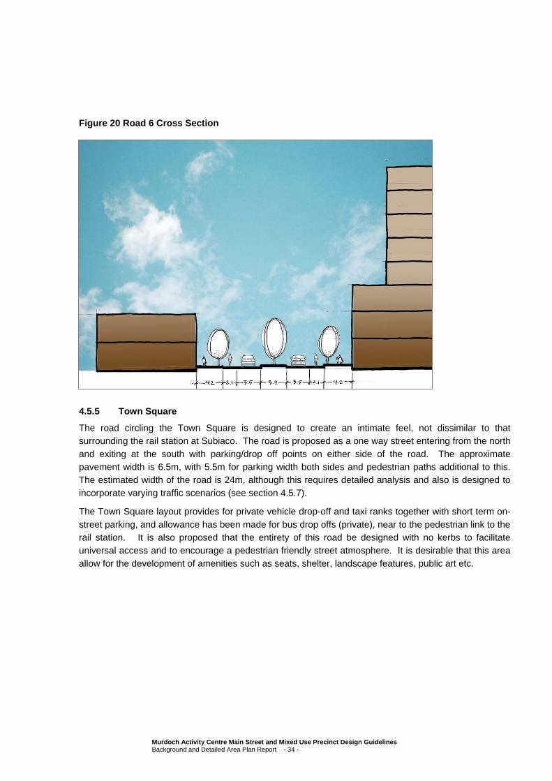
Figure 20 Road 6 Cross Section
4.5.5 Town Square
The road circling the Town Square is designed to create an intimate feel, not dissimilar to that surrounding the rail station at Subiaco. The road is proposed as a one way street entering from the north
and exiting at the south with parking/drop off points on either side of the road. The approximate pavement width is 6.5m, with 5.5m for parking width both sides and pedestrian paths additional to this. The estimated width of the road is 24m, although this requires detailed analysis and also is designed to
incorporate varying traffic scenarios (see section 4.5.7).
The Town Square layout provides for private vehicle drop-off and taxi ranks together with short term on-street parking, and allowance has been made for bus drop offs (private), near to the pedestrian link to the
rail station. It is also proposed that the entirety of this road be designed with no kerbs to facilitate universal access and to encourage a pedestrian friendly street atmosphere. It is desirable that this area allow for the development of amenities such as seats, shelter, landscape features, public art etc.
Murdoch Activity Centre Main Street and Mixed Use Precinct Design Guidelines Background and Detailed Area Plan Report - 34 -

Kerb less urban environments
4.5.6 Service Road
Access to the Mixed Use Precinct from South Street is from a left in/left out turn only (Road 6 Figure 12), so it is expected that the vehicular traffic via this entrance will be limited. A short local-traffic-only road
(the service road) provides access to the lots at the northernmost part of the Mixed Use Precinct. It was considered that through traffic in this location would create confusion at the intersection of Main Street, and for this reason it has been designed as a no thru road and with an approximate width of 16m. It is
designed to be similar to an Access Street ‘D’ with an additional 2m wide median to support pedestrian activity.
Murdoch Activity Centre Main Street and Mixed Use Precinct Design Guidelines Background and Detailed Area Plan Report - 35 -

It is likely that this service road will provide access to underground car parks for the above development,
and so the design of the street will need to incorporate ramps down. Careful consideration of pedestrian movements will need to occur in the detailed design of these ramps accesses.
It is proposed that the majority of this road be designed as kerb less leading towards the kerb less
environment of the Town Square, and buildings either side of the Service Road are proposed to be quite tall, as can be illustrated in Figure 21. Bollards and active frontages will have a role to play in maintaining safe and interesting street edges for pedestrians.
Figure 21 Service Road Cross Section
4.5.7 Future Road – Over Freeway
A road has been allowed for in this design to traverse the freeway at approximately the same point as the
end of the rail platform below. It has been designed with an approximate width of 18m to allow for two way vehicle movements, bicycle traffic in dedicated bicycle lanes, and pedestrian movements either side.
This potential for this road to be incorporated into the precinct will be determined through a number of
other studies; however, the principle of the road is to connect the Main Street and Mixed Use Precinct quadrant of the Freeway/South Street intersection with the other quadrants at some stage into the future. This connection was seen as an important one in the early stages of planning for the precinct, and
pedestrian and cycle connections to the precinct have been a matter of public interest throughout the project.
Murdoch Activity Centre Main Street and Mixed Use Precinct Design Guidelines Background and Detailed Area Plan Report - 36 -
Further investigation into this link will determine its necessity, and the preferred design allows for the
development of this area in the case that no link is ever made.
4.6 Pedestrian and Cycle Networks
Pedestrian links and cycle ways are necessary to activate the Mixed Use Precinct. Successful pedestrian links will have active uses opening onto them, and encourage the flow of activity along them. Pedestrian links should incorporate visual interest and activity by the use of retail facilities and other
activities.
Cycle paths should be clear and easy to see for cyclists and vehicles, and adequate cycle facilities will need to be provided in the precinct to allow for storage and protection of bicycles for precinct users.
Pedestrian links throughout the Main Street and Mixed Use Precinct shall ensure safe and convenient universal access through the provision of access ramps, handrails and variation in texture and colour detailing and development proposed adjacent to the intersections of pedestrian links shall provide
directional signage for way-finding.
Shelter should be provided along all pedestrian linkages through either building edges or via free standing structures. The use of colonnades or awnings will be required for all street frontages, whilst
open space areas will need to consider pedestrian comfort.
4.6.1 Main Street
The majority of Main Street is designed to allow for both pedestrian and cyclist movements. At the intersection of Road 6 the pedestrian route splits from the vehicular path and follows a path directly
towards the pedestrian entrance of the bus and rail station, past the town square. The northern most part of Main Street become a bus only way, with no stopping, and whilst 4.0m wide pedestrian paths on either side are provided this will not be designed to encourage substantial pedestrian movement.
The difference in level along Main Street to the adjacent conservation area provides for an interesting and complex pedestrian environment, and a series of steps and plateaus or decked areas are likely to create many different spaces. The design of these spaces will need to consider cyclists and pedestrians
carefully, and shelter will need to be provided along the path on the southern side of Main Street in the absence of the built form which provides shelter for the majority of the precinct.
4.6.2 Mixed Use Precinct Road (and Road 6)
Road 6 allows for on road cycle movements and the road reserve comprises pedestrian paths to both
sides south of the elongated roundabout and north of Main Street. Adjacent to the conservation area the road reserve allows for on cycle road movements in both directions but only allows for pedestrian paths on the western side of the road.
The Mixed Use Precinct Road will also allow for on road cycle movements and pedestrian paths to both sides through to the Town Square, with footpaths approximately 4m wide on either side.
A pedestrian link between Road 6 and the Mixed Use Precinct Road through the conservation area has
been identified as a possibility in the future subject to negotiations with the Commonwealth Department of Environment, Water, Heritage and the Arts. This link is likely to be a pedestrian link only.
Murdoch Activity Centre Main Street and Mixed Use Precinct Design Guidelines Background and Detailed Area Plan Report - 37 -
4.6.3 Town Square
The Town Square is proposed to be designed with no kerbs to facilitate universal access and to
encourage a pedestrian friendly street atmosphere. The road pavement should be designed of different materials to the adjacent streets to signify a change in the vehicular environment pedestrians should be given right of way. Signage will need to be installed to clearly identify this area as a pedestrian and cycle
friendly zone. There will not be dedicated cycle ways but the road will be speed limited.
Pedestrian safety should be considered through the use of bollards or other street furniture to clearly delineate the vehicle and pedestrian spaces.
End of trip cycle facilities should be abundant, and it would be desirable for a facility such as a city rest place or similar to be located in buildings adjacent to the town square.
4.6.4 Service Road
The service road will also be a kerb-less environment, and it is proposed that on street cycle ways and
4m wide pedestrian paths flank the road. The pedestrian and cycle network at the end of the Service Road through to the Mixed Use Precinct should be clearly signposted to encourage movement of pedestrians from this area and from the adjacent neighbourhoods and St John of God Hospital.
Cyclists and pedestrians will be encouraged to cross the bus link rather than Main Street, where traffic is two lanes only with a substantial traffic island in the centre. Although public transport buses will have priority over private vehicles on Main Street, it is proposed that at this point a pedestrian crossing be
marked to provide pedestrian priority.
4.6.5 Future Road – Over Freeway
The link over the Freeway is subject to further investigations, however, it is proposed as a minimum to provide a pedestrian overpass of the Freeway at this point to connect to both the southern end of the rail
platform below and to the residential neighbourhood in the south east quadrant of the Freeway/South Street intersection.
4.7 Public Transport Networks
Main Street provides a major public transport network through the study area, linking with the Murdoch
rail station. The majority of buses that currently travel west along South Street will eventually travel along Main Street first, before turning at Murdoch Drive either back to South Street, south to Farrington Road or directly into the Murdoch University Eastern Precinct.
Bus services through this route will be frequent, travelling out to many parts of the southern suburbs and linking with the rail station to go directly into the city or south to Mandurah. Bus stops will be located in accordance with the Fiona Stanley Hospital Precinct Master Plan.
Main Street has been designed so as to maintain a street layout with a focus on encouraging public transport services, with dedicated bus lanes on either side continuing into the Mixed Use Precinct and buses stopping in the Priority Bus Lane. A bus link at the northern end of Main Street separates the
public transport route from the private vehicle route, and the bus route maintains priority, except for a single pedestrian crossing into the Town Square area from the west.
Murdoch Activity Centre Main Street and Mixed Use Precinct Design Guidelines Background and Detailed Area Plan Report - 38 -

Development proposed adjacent to bus stops should provide enough physical space between the
building and the stop for comfortable pedestrian usage and should provide shelter. Bus shelters should be easily identified from the road and from the footpath.
Pedestrian networks should support clear way-finding to public transport stops with signage to indicate
distance from stops. A key feature of the Mixed Use Precinct would be the installation of intelligent signage such as electronic displays identifying time to next departure for trains as this would encourage patrons to spend additional time in the Mixed Use Precinct rather than on a rail platform. Intelligent
transport systems (signage etc) are not currently funded for this precinct, but should be considered by the PTA or other service providers in future funding for the Mixed Use Precinct.
4.8 Street Block Layout
The street blocks have been designed to allow for useable commercial tenancies at the same time as supporting the legibility of the Precinct. It has also been considered fundamental to the design of the
precinct that a visual connection be established to the town square and through to the rail station and this has informed the need to have street blocks that act as an extension of streets approaching the precinct.
The town square can be seen from nearly all lots within the Mixed Use Precinct, and will be visible from
most elevated areas within the Main Street and Mixed Use Precinct. Additionally, built form in the way of taller buildings will be encouraged at the closest point to the rail station and town square to promote way finding.
The street blocks address both the north south access and the Main Street access to the Mixed Use Precinct. Design of buildings along the street blocks will also play a big part in way finding through the precinct and it is proposed that the streets be framed by buildings with active edges on both sides. This
is discussed further in Section 4.16 and 4.18.
4.9 Transportation Corridors
Main Street and Road 6 have been identified as having a transport function for the broader Main Street and Mixed Use Precinct. Main Street will provide all public transport bus movements through the precinct, whilst Road 6 has been identified as having a support function for transport/services through to
the Fiona Stanley Hospital. A signalised intersection at Main Street and Road 6 is highly likely, and has been designed to accommodate this in the future (not currently funded). Ensuring that Main Street maintains priority, for private and public transport vehicles alike should be a priority.
The Freeway and South Street perform very important regional transport functions, and the integration of the Main Street and Mixed Use Precinct should encourage overlooking into these areas but should not allow for disruption of the roads more than is necessary. A single left in left out access from the Main
Street and Mixed Use Precinct onto South Street has been designed for limited impact to the regional road network.
Development adjacent to the Freeway and to South Street should consider State Planning Policy 5.4
Road and Rail Transport Noise and Freight Considerations in Land Use Planning.
Murdoch Drive also forms an important part of the network. Development adjacent to the intersection of Murdoch Drive and Main Street should promote a sense of arrival to support traffic ease at entrances
and exits to the respective precincts.
Murdoch Activity Centre Main Street and Mixed Use Precinct Design Guidelines Background and Detailed Area Plan Report - 39 -

4.10 Community Facilities
Consideration of the development of public facilities immediately adjacent to the station should be given.
These facilities should include end of journey facilities such as showers, bicycle parking bays, lockers and change rooms and should also include public rest areas, public phones and relevant local travel information such as bus and train routes, maps and timetables2. Signage should incorporate familiar
symbols and provide advice on walking times and distances.
This facility could be incorporated into a broader multi-purpose facility for the community, comprising recreation facilities, youth facilities, a rest place (similar to the City of Perth ‘Citiplace’) day care and
potentially some library services.
In addition to this type of community facility, there is adequate support for a Civic Building in the Mixed Use Precinct, perhaps a presence for the City of Melville, to be located prominently close to the Town
Square. Such a facility could provide a satellite office for Council Services and could comprise functions such as dedicated TravelSmart officers, library functions, payment services etc.
Other community facilities and services could include a Lotteries House type facility comprising allied
health support services, emergency care facilities for the homeless and those attracted to the precinct’s medical facilities, community and elderly care providers, accommodation for indigenous families from remote areas and a short term medi hotel in support of the hospital services of the precinct. These
facilities would be appropriately located in the Health Support Precinct, subject to further research into their necessity.
4.11 Public Open Space
In addition to the large area proposed for conservation, the preferred design for the Mixed Use Precinct incorporates a number of open spaces and public places. The Town Square is large enough to
accommodate substantial planting and the creation of a ‘Central Park’ type garden and seating area. Similarly, the space between the conservation area and Main Street can be utilised to create a series of stepped areas overlooking the conservation area, which could include covered pavilions and even small
transportable stands or community display areas.
It is also proposed to encourage a link between the Mixed Use Precinct Road and the conservation area. Development adjacent to both of these areas should provide open frontages to both sides and will be
encouraged to incorporate arcades through to the conservation area. The conservation area is some 6m below the finished level of the Mixed Use Precinct Road and adjacent buildings and so developers will be encouraged to incorporate decked areas at the edge of the retaining, or stepped alfresco areas.
Railing along the edge of the conservation area will be encouraged to be predominantly open, although an impermeable lower half should be developed to halt the flow of items of street debris into the space. The use of visually permeable materials will be encouraged to achieve this rather than a solid wall.
All planting and landscaping within the precinct should consider the use of flora species able to be used by Carnaby’s Black Cockatoo for foraging, including the following species:
Dryandra;
Eucalyptus;
2 It should be noted that a community service facility for showers and change rooms etc should not be seen as a substitute for
private office and commercial infrastructure in the precinct to provide individual occupant facilities
Murdoch Activity Centre Main Street and Mixed Use Precinct Design Guidelines Background and Detailed Area Plan Report - 40 -

Grevillea;
Hakea; and
Lambertia.
These species also form part of the landscaping Masterplan treatments for the Fiona Stanley Hospital
area, and the broader use of these species will ensure that a common planting theme occurs throughout the Main Street and Mixed Use Precinct.
Development within the Precinct is encouraged to consider input from Commonwealth Department of
Environment, Water, Heritages and the Arts (DEHWA) on the appropriate landscaping within the area.
4.12 Street Furniture, Signage and Lighting
The development of the Main Street and Mixed Use Precinct should achieve high standards of amenity, in both the design standards of street furniture including seating, rubbish bins and lighting and the design standards of the street pavements and finishes. The following images (Figure 22) reflect the finishes and
treatments that should reflect the standard of the precinct. Detailed landscaping and master plan design for the Main Street and Mixed Use Precinct should be undertaken in full consultation with the City of Melville and the Department of Planning, and should also include all other precinct stakeholders.
Murdoch Activity Centre Main Street and Mixed Use Precinct Design Guidelines Background and Detailed Area Plan Report - 41 -
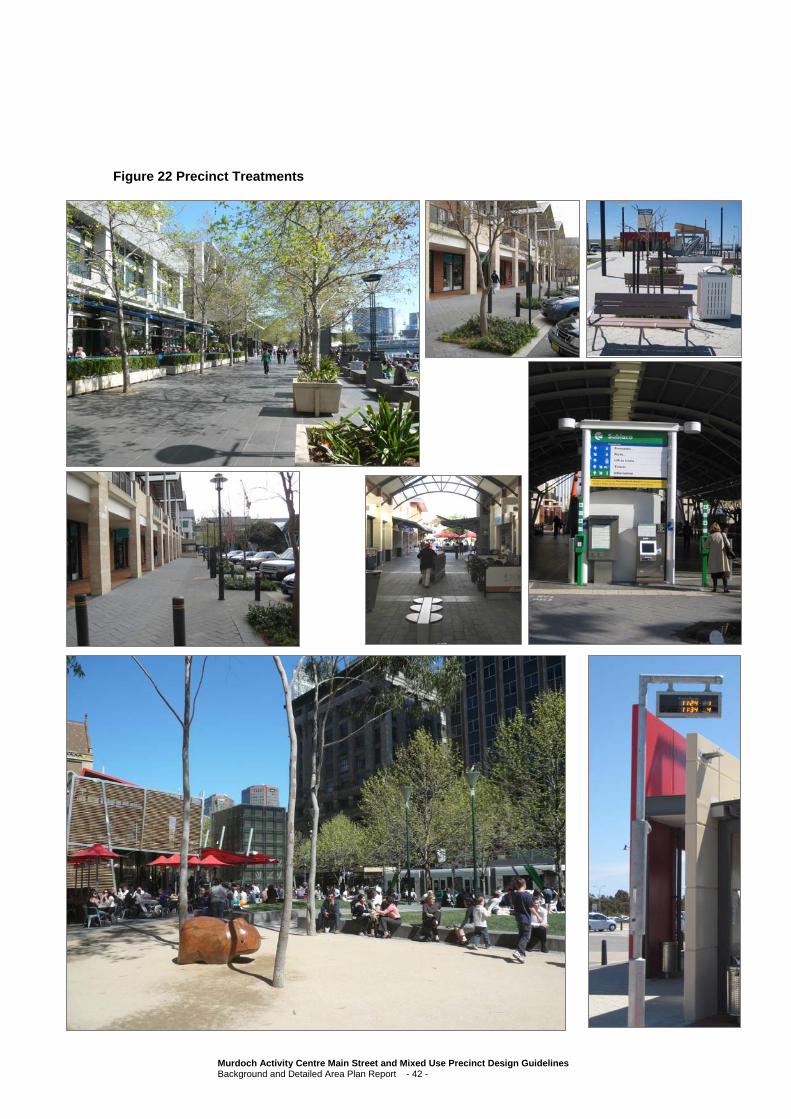
Figure 22 Precinct Treatments
Murdoch Activity Centre Main Street and Mixed Use Precinct Design Guidelines Background and Detailed Area Plan Report - 42 -
4.13 Proposed Land Uses
The Main Street and Mixed Use Precinct should be a place of activity during daylight and evening hours.
Land uses that promote movement and activity are encouraged throughout the area.
The proposed land uses for the study area that have been generally agreed to by all stakeholders include uses such as offices, entertainment, retail around the town square, a tavern, a small
supermarket, a gym or other lifestyle land uses, non-core health focused service providers, para-medical and other health related services.
This section looks at the proposed land uses which would be;
– Appropriate – i.e. Permitted; and
– Inappropriate – i.e. Not Permitted,
in the Precinct.
Whilst Section 4.14 provides more guidance as to the appropriate location of land uses, the following provides a list of uses that should be considered appropriate in the study area, reflecting the Use Class Table terminology in the City of Melville Community Planning Scheme No. 5:
– Amenity Building
– Amusement Facility
– Car Park
– Child minding centre
– Cinema/Theatre
– Civic Building
– Community Purpose
– Conservation/Recreation
– Convenience store (not including Service Station facilities)
– Small Bar/Hotel/Tavern (‘drive through’ establishments not permitted)
– Lunch Bar/Take Away Food (‘drive through’ establishments not permitted)
– Medical Centre
– Office
– Public Amusement
– Public Exhibition
– Reception Centre
– Residential
– Restaurant
– Retail
– Shop
Murdoch Activity Centre Main Street and Mixed Use Precinct Design Guidelines Background and Detailed Area Plan Report - 43 -

– Wine House
– Educational establishment
– Consulting Rooms
Uses within that are considered inappropriate for the study area are:
– Industrial
– Bulky goods retailing
– Service station
– Showroom
– Other large space consuming uses that provide little activity.
4.14 Proposed Land Use Areas
The precincts within the study area; being the Mixed Use Precinct, Health Support Precinct, Hospital Main Street and Murdoch University Eastern Precinct (Mixed Use Precinct, Health Support Precinct,
Hospital Main Street and Murdoch University Eastern Precinct) must each be considered slightly differently due to a number of unique factors.
4.14.1 Mixed Use Precinct
The Mixed Use Precinct falls within 400m of the train station or a 5 minute walk. This area is expected to
have high amenity, a town square area, some linkages through to the conservation area, Kiss’n’Ride facilities and will generally not encourage through traffic at speed. The Mixed Use Precinct is also expected to be utilised by a large number of public transport users, either coming to, or leaving from the
precinct on foot, bicycle, bus and rail.
This area is immediately adjacent to the health precinct comprising the Fiona Stanley Hospital, St John of God Hospital and the Murdoch Medical Clinic where it is expected that most, if not all, of the health
related services in the precinct will gravitate. As a result, the preferred uses in the Mixed Use Precinct steer away from uses such as Consulting Rooms, unless there is an identified shortage of floor area in the Main Street area.
In the same manner, the Murdoch University and Challenger TAFE caters for substantial educational services in the area, and the Murdoch University Precinct and Challenger TAFE site will certainly attract more education based uses. Subsequently, the development of educational and research
establishments in the Mixed Use Precinct should only be supported if there is an identified shortage of floor area in the Murdoch University Precinct and Challenger TAFE site.
Murdoch Activity Centre Main Street and Mixed Use Precinct Design Guidelines Background and Detailed Area Plan Report - 44 -
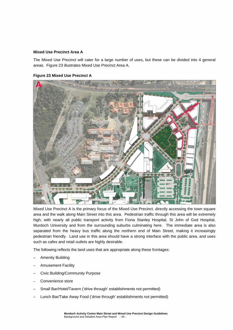
Mixed Use Precinct Area A
The Mixed Use Precinct will cater for a large number of uses, but these can be divided into 4 general areas. Figure 23 illustrates Mixed Use Precinct Area A.
Figure 23 Mixed Use Precinct A
Mixed Use Precinct A is the primary focus of the Mixed Use Precinct, directly accessing the town square area and the walk along Main Street into this area. Pedestrian traffic through this area will be extremely
high, with nearly all public transport activity from Fiona Stanley Hospital, St John of God Hospital, Murdoch University and from the surrounding suburbs culminating here. The immediate area is also separated from the heavy bus traffic along the northern end of Main Street, making it increasingly
pedestrian friendly. Land use in this area should have a strong interface with the public area, and uses such as cafes and retail outlets are highly desirable.
The following reflects the land uses that are appropriate along these frontages:
– Amenity Building
– Amusement Facility
– Civic Building/Community Purpose
– Convenience store
– Small Bar/Hotel/Tavern (‘drive through’ establishments not permitted)
– Lunch Bar/Take Away Food (‘drive through’ establishments not permitted)
Murdoch Activity Centre Main Street and Mixed Use Precinct Design Guidelines Background and Detailed Area Plan Report - 45 -
– Public Amusement
– Public Exhibition
– Restaurant
– Retail
– Shop
– Wine House
These uses all have a strong street presence – ‘open for business’ to the street. A rich mix of these uses
should be encouraged to extend the hours of activity within the centre, and ensure that the use is more than retail alone. Continuous frontages should be encouraged with large amounts of glazing.
The location of a Community Purpose building in the northern part of the precinct to be available for the
use of public transport patrons, such as a shower and change room facility, is highly desirable and should form part of early land use considerations.
Murdoch Activity Centre Main Street and Mixed Use Precinct Design Guidelines Background and Detailed Area Plan Report - 46 -
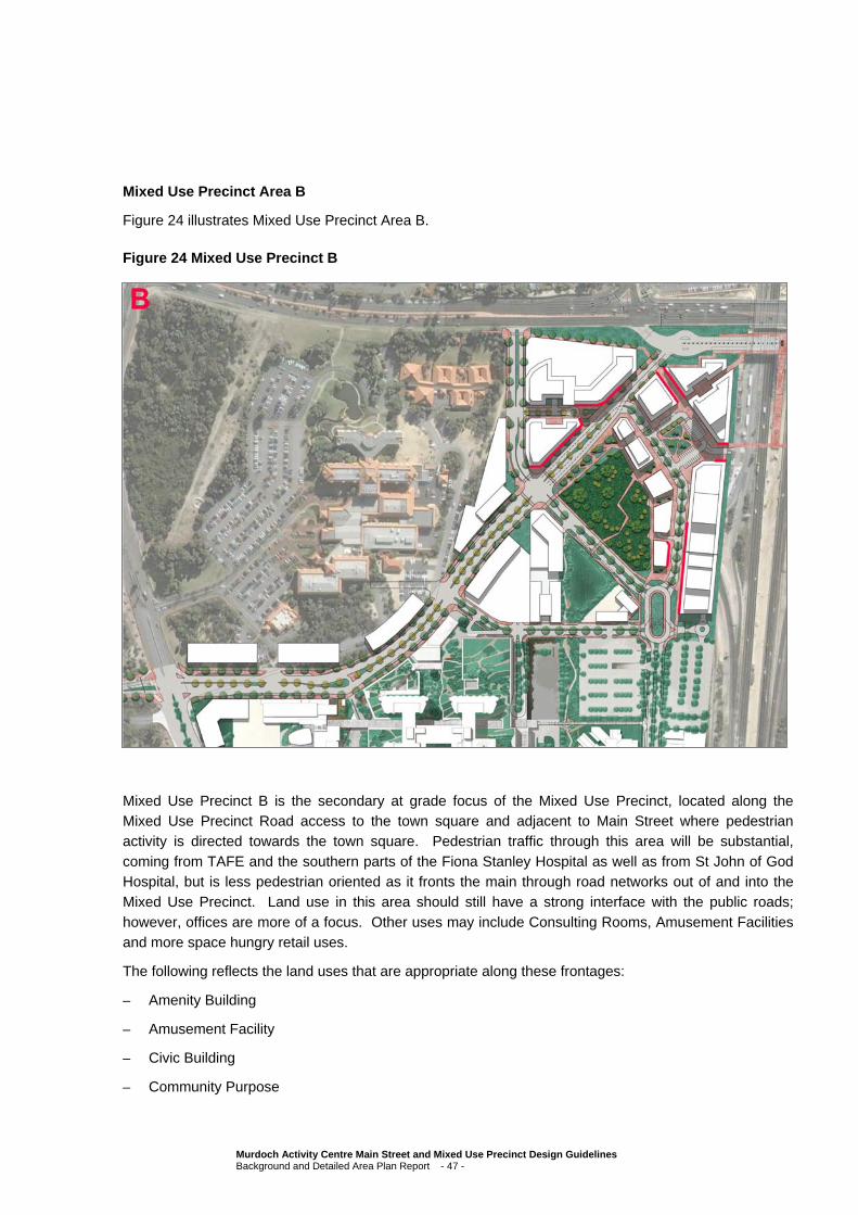
Mixed Use Precinct Area B
Figure 24 illustrates Mixed Use Precinct Area B.
Figure 24 Mixed Use Precinct B
Mixed Use Precinct B is the secondary at grade focus of the Mixed Use Precinct, located along the Mixed Use Precinct Road access to the town square and adjacent to Main Street where pedestrian activity is directed towards the town square. Pedestrian traffic through this area will be substantial,
coming from TAFE and the southern parts of the Fiona Stanley Hospital as well as from St John of God Hospital, but is less pedestrian oriented as it fronts the main through road networks out of and into the Mixed Use Precinct. Land use in this area should still have a strong interface with the public roads;
however, offices are more of a focus. Other uses may include Consulting Rooms, Amusement Facilities and more space hungry retail uses.
The following reflects the land uses that are appropriate along these frontages:
– Amenity Building
– Amusement Facility
– Civic Building
– Community Purpose
Murdoch Activity Centre Main Street and Mixed Use Precinct Design Guidelines Background and Detailed Area Plan Report - 47 -
– Conservation/Recreation
– Convenience store
– Lunch Bar/Take Away Food (‘drive through’ establishments not permitted)
– Office
– Public Amusement
– Public Exhibition
– Reception Centre
– Retail
– Shop
This area provides an ‘entry’ into the Precinct, introducing the general character of the precinct; less
active than the central activity area such that the central activity area is clearly ahead, but beginning to provide on street activity that complements the more intense uses of the core.
Office uses should be encouraged, especially if they are frequently used such as a bank or a post office.
Less busy office types should similarly be discouraged at this level.
Murdoch Activity Centre Main Street and Mixed Use Precinct Design Guidelines Background and Detailed Area Plan Report - 48 -
Area C
Figure 25 illustrates Mixed Use Precinct Area C.
Figure 25 Mixed Use Precinct C
Mixed Use Precinct C comprises all at grade land area not fronting directly onto Main Street, the Mixed Use Precinct Road and the Town Square area. Pedestrian activity is likely to be limited to pedestrians coming from the northern side of South Street and from the northern part of St John of God Hospital and
the majority of this area fronts main through road networks or is located along the freeway. Land use in this area should have a strong focus on office space and on uses that require limited street frontage exposure but substantial space, such as Cinemas and Recreation facilities (gymnasiums).
The following reflects the land uses that are appropriate along these frontages:
– Amenity Building
– Amusement Facility3
– Car Park
– Child minding centre
3 It should be noted that whilst Amusement Facility is encouraged adjacent to these frontages, it is not considered appropriate for
an Amusement Facility to be located opposite to the SJOGH Palliative Care facility at the northern most part of the MAC.
Murdoch Activity Centre Main Street and Mixed Use Precinct Design Guidelines Background and Detailed Area Plan Report - 49 -

– Cinema/Theatre
– Civic Building
– Community Purpose
– Conservation/Recreation
– Lunch Bar/Take Away Food (‘drive through’ establishments not permitted)
– Office
– Public Amusement
– Public Exhibition
– Reception Centre
– Retail
– Consulting Rooms
Uses that attract patrons but are nevertheless more private should be encouraged in this area. This would include uses such as gyms and cinemas that need some privacy from the street or office uses like
law firms that rely on confidential/private spaces but would still benefit from street frontage.
Murdoch Activity Centre Main Street and Mixed Use Precinct Design Guidelines Background and Detailed Area Plan Report - 50 -

Area D
Figure 26 illustrates Mixed Use Precinct Area D.
Figure 26 Mixed Use Precinct Area D
Mixed Use Precinct D represents development above ground floor level that do not have direct street frontage.
At first floor level office uses are encouraged, as are uses that do not require a shop front but still
encourage activity at ground level. Uses may include restaurants, reception centres and taverns which have a balcony element. Development at this level should still have an active day time use and as a result residential is not encouraged here. The development of residential forms an important part of the
Mixed Use Precinct, but should be developed at higher levels; also, at higher levels residential development will be able to separate from the noise of the Precinct.
The following reflects the land uses that are appropriate above ground level:
– Amenity Building
– Amusement Facility4
4 It should be noted that whilst Amusement Facility is encouraged adjacent to these frontages, it is not considered appropriate for
an Amusement Facility to be located opposite to the St John of God Hospital Palliative Care facility at the northern most part of the MAC.
Murdoch Activity Centre Main Street and Mixed Use Precinct Design Guidelines Background and Detailed Area Plan Report - 51 -
– Car Park
– Child minding centre
– Cinema/Theatre
– Civic Building
– Community Purpose
– Conservation/Recreation
– Small Bar/Hotel/Tavern5 (‘drive through’ establishments not permitted)
– Medical Centre
– Office
– Public Amusement
– Reception Centre5
– Residential (second/third floor and above)
– Restaurant5
– Wine House
– Consulting Rooms
Uses that attract patrons but do not rely on street frontage should be encouraged. Residential uses
should not be encouraged at lower levels, but could be supported as a short term use subject to the appropriate design of the development for future alternative uses.
5 It should be noted that whilst Small Bar/Hotel/Tavern, Restaurant and Reception Centre are encouraged adjacent to these
frontages, it is not considered appropriate for a Small Bar/Hotel/Tavern, Restaurant or Reception Centre with balconies to be located opposite to the St John of God Hospital Palliative Care facility at the northern most part of the MAC.
Murdoch Activity Centre Main Street and Mixed Use Precinct Design Guidelines Background and Detailed Area Plan Report - 52 -
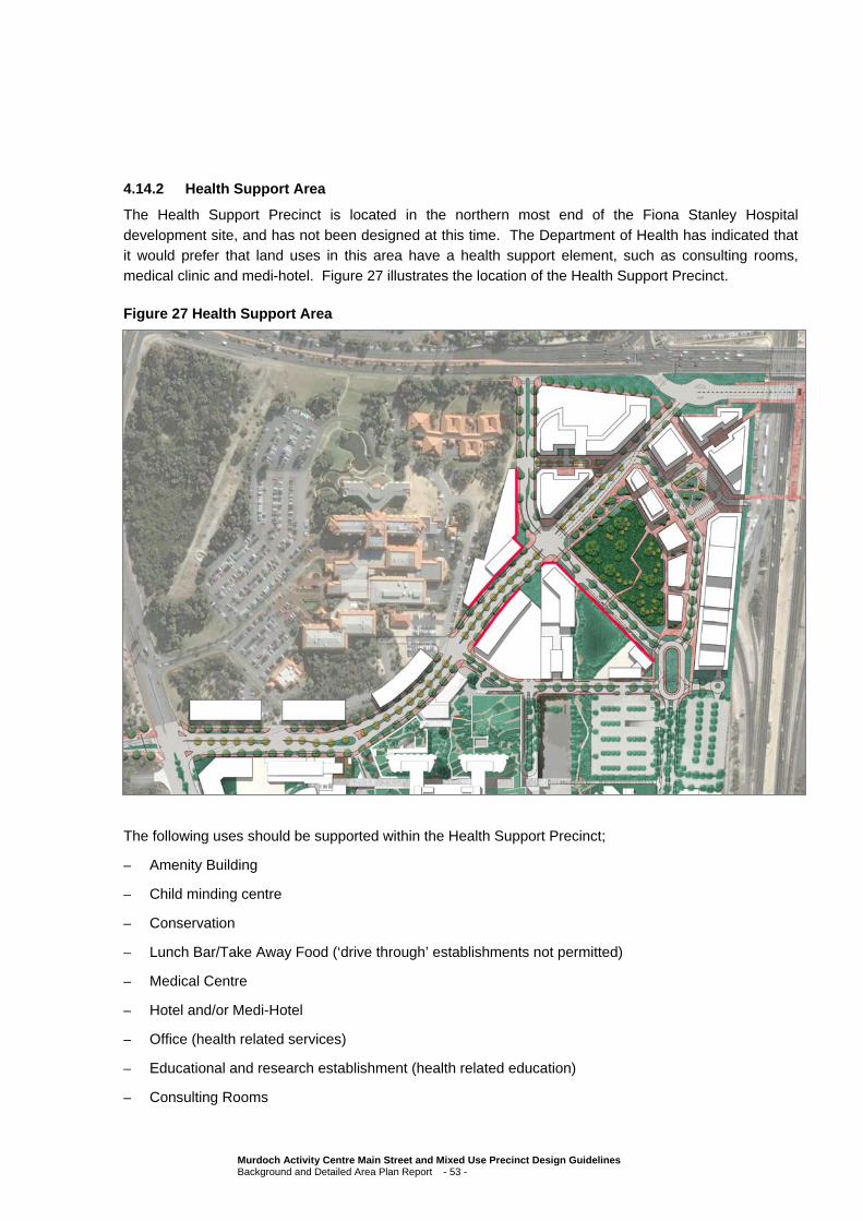
4.14.2 Health Support Area
The Health Support Precinct is located in the northern most end of the Fiona Stanley Hospital
development site, and has not been designed at this time. The Department of Health has indicated that it would prefer that land uses in this area have a health support element, such as consulting rooms, medical clinic and medi-hotel. Figure 27 illustrates the location of the Health Support Precinct.
Figure 27 Health Support Area
The following uses should be supported within the Health Support Precinct;
– Amenity Building
– Child minding centre
– Conservation
– Lunch Bar/Take Away Food (‘drive through’ establishments not permitted)
– Medical Centre
– Hotel and/or Medi-Hotel
– Office (health related services)
– Educational and research establishment (health related education)
– Consulting Rooms
Murdoch Activity Centre Main Street and Mixed Use Precinct Design Guidelines Background and Detailed Area Plan Report - 53 -
A substantial part of this area will be set aside for open space purposes and development would be
encouraged to front onto both the Main Street and the open space area.
4.14.3 Hospital Main Street
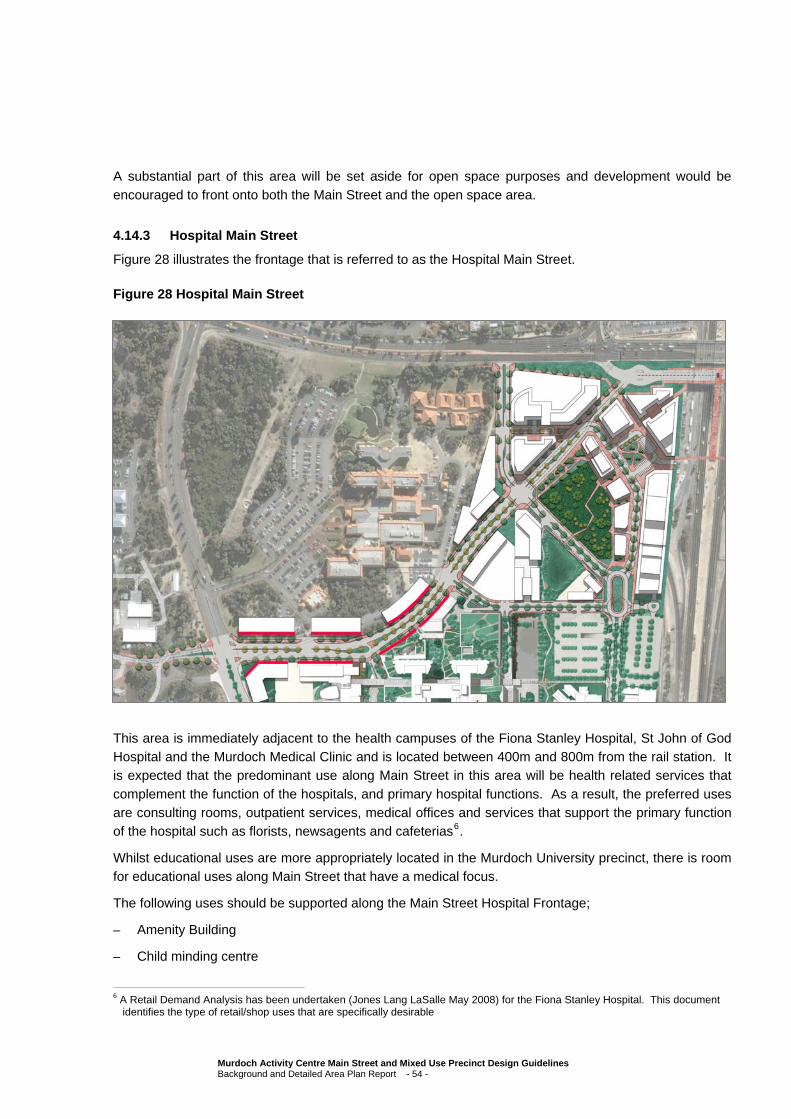
Figure 28 illustrates the frontage that is referred to as the Hospital Main Street.
Figure 28 Hospital Main Street
This area is immediately adjacent to the health campuses of the Fiona Stanley Hospital, St John of God Hospital and the Murdoch Medical Clinic and is located between 400m and 800m from the rail station. It is expected that the predominant use along Main Street in this area will be health related services that
complement the function of the hospitals, and primary hospital functions. As a result, the preferred uses are consulting rooms, outpatient services, medical offices and services that support the primary function of the hospital such as florists, newsagents and cafeterias6.
Whilst educational uses are more appropriately located in the Murdoch University precinct, there is room for educational uses along Main Street that have a medical focus.
The following uses should be supported along the Main Street Hospital Frontage;
– Amenity Building
– Child minding centre
6 A Retail Demand Analysis has been undertaken (Jones Lang LaSalle May 2008) for the Fiona Stanley Hospital. This document
identifies the type of retail/shop uses that are specifically desirable
Murdoch Activity Centre Main Street and Mixed Use Precinct Design Guidelines Background and Detailed Area Plan Report - 54 -
– Convenience store
– Lunch Bar/Take Away Food (‘drive through’ establishments not permitted)
– Medical Centre
– Office
– Retail
– Shop
– Educational and research establishment
– Consulting Rooms
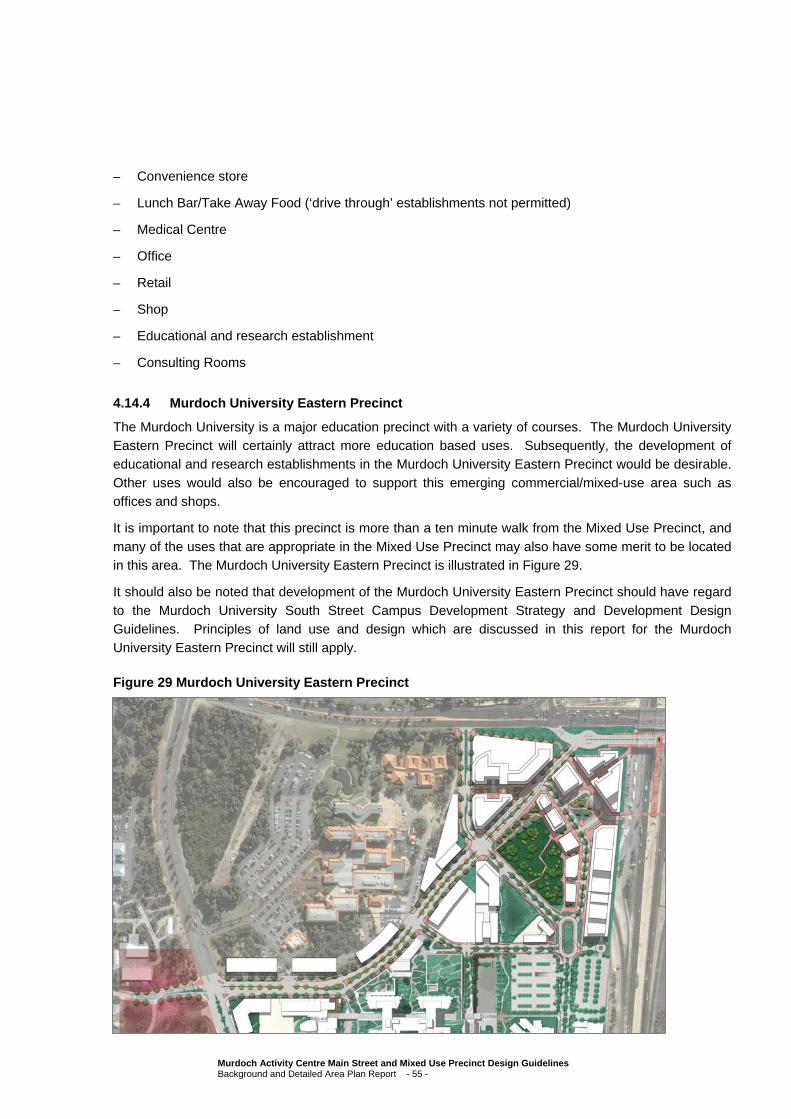
4.14.4 Murdoch University Eastern Precinct
The Murdoch University is a major education precinct with a variety of courses. The Murdoch University Eastern Precinct will certainly attract more education based uses. Subsequently, the development of educational and research establishments in the Murdoch University Eastern Precinct would be desirable.
Other uses would also be encouraged to support this emerging commercial/mixed-use area such as offices and shops.
It is important to note that this precinct is more than a ten minute walk from the Mixed Use Precinct, and
many of the uses that are appropriate in the Mixed Use Precinct may also have some merit to be located in this area. The Murdoch University Eastern Precinct is illustrated in Figure 29.
It should also be noted that development of the Murdoch University Eastern Precinct should have regard
to the Murdoch University South Street Campus Development Strategy and Development Design Guidelines. Principles of land use and design which are discussed in this report for the Murdoch University Eastern Precinct will still apply.
Figure 29 Murdoch University Eastern Precinct
Murdoch Activity Centre Main Street and Mixed Use Precinct Design Guidelines Background and Detailed Area Plan Report - 55 -

4.15 Built Form
Generally, the development of the precinct should have a high standard of architectural quality,
interesting use of materials and colour, active frontages and be sensitive to human scale at the street edge. Furthermore, development should be cognisant of the nature of the Main Street and Mixed Use Precinct as being a busy and active area, and should consider materials that can be easily maintained
and be designed with the appropriate attenuation techniques for noise. Sections 4.16 through to 4.18 consider this in more detail.
4.16 Building Heights and Massing
A fundamental objective of this precinct is to encourage a built edge along Main Street and surrounding the Town Square that frames these areas and encourages activity. As a general rule there is an
expectation that all development will have a minimal setback to the property boundary, between nil and 1 metre. The use of colonnades may also be encouraged on the south side of Main Street and the Town Square for both active alfresco uses and for shade and shelter.
Ground floor frontages should be encouraged to provide shelter where practicable for pedestrians by way of awnings over pavements, setbacks at ground floor to create colonnades or a combination of both.
Building height is ultimately limited by the Jandakot Aerodrome’s air space protection through CASA,
however, consideration of overshadowing impacts, view corridors and way finding have been considered in the development of maximum building heights throughout the Main Street and Mixed Use Precinct. Also considered has been the inclusion of minimum building heights in the precinct, to ensure that
adequate minimum built form is developed to support and encourage the activity within the area.
The building heights proposed identify the minimum and maximum height allowed in each part of the Main Street and Mixed Use Precinct, prior to any bonus development standards being applied to each
site (bonus development standards are proposed for developments where the developer includes public art, exceptional design quality, public spaces, affordable housing or other community services).
Figure 30 illustrates the minimum and maximum building heights in the Study area.
Murdoch Activity Centre Main Street and Mixed Use Precinct Design Guidelines Background and Detailed Area Plan Report - 56 -

Figure 30 Building Heights
In considering these building heights some modelling was done to establish the actual impact of these heights. Figure 31 illustrates conceptually how these heights are reflected once developed, showing a
perspective looking northeast across the conservation area.
Murdoch Activity Centre Main Street and Mixed Use Precinct Design Guidelines Background and Detailed Area Plan Report - 57 -

Figure 31 Mixed Use Precinct Building Massing
4.17 Proposed Density
The only precinct in the study area where residential development is considered appropriate is the Mixed Use Precinct. Most areas of the Mixed Use Precinct are considered to be appropriate for high density
residential development, except for the development sites fronting the conservation area. Development on these sites is limited in height to conserve the environmental values of the conservation area subject to further discussion with the federal Department of Sustainability, Environment, Water, Population and
Communities.
High density residential development is considered most appropriate in the northern and eastern most part of the Mixed Use Precinct, however, it is also important to consider the impact of overshadowing on
the town square area.
Density will be largely controlled by height and setback limits, and as such no density maximum will be established. Full development of the Mixed Use Precinct, limited by the height and setback controls
identified in this Detailed Area Plan and the subsequent Design Guidelines, will result in the development of approximately 1000 apartments with an average floor area of 90m², approximately 60,000 m² of office and retail floor space in the Mixed Use Precinct and approximately 40,000 m² of medically related floor
space on the Fiona Stanley Hospital Health Precinct campus.
This has the potential to result in a residential population of approximately 2000 people, assuming an average of 2 persons per dwelling based on the size of the average dwelling.
Murdoch Activity Centre Main Street and Mixed Use Precinct Design Guidelines Background and Detailed Area Plan Report - 58 -

To encourage the development of a range of apartments, affordable housing and housing which
responds to principles of sustainability and equity, it is proposed that bonus height and setback and other variations be granted.
4.18 Building Setbacks
Whilst it is considered appropriate for the buildings throughout the Main Street and Mixed Use Precinct to have minimal setbacks and to create an urban edge, there is also a need to consider the scale of the
developments from a user perspective.
For this reason all buildings which consist of more than four storeys (or about 16-18m in height) of development are proposed to be setback five metres from the street frontage above the podium level. In
this way, the bulk and scale of the street at pedestrian level is relatively low, whilst from a distance the actual height of buildings can be quite considerable.
The setback podium that will be established by these setbacks is encouraged to be developed with
outdoor spaces, roof top gardens and otherwise publicly accessible spaces. The image below illustrates how a rooftop terrace may be integrated into the fabric of the building.
Murdoch Activity Centre Main Street and Mixed Use Precinct Design Guidelines Background and Detailed Area Plan Report - 59 -
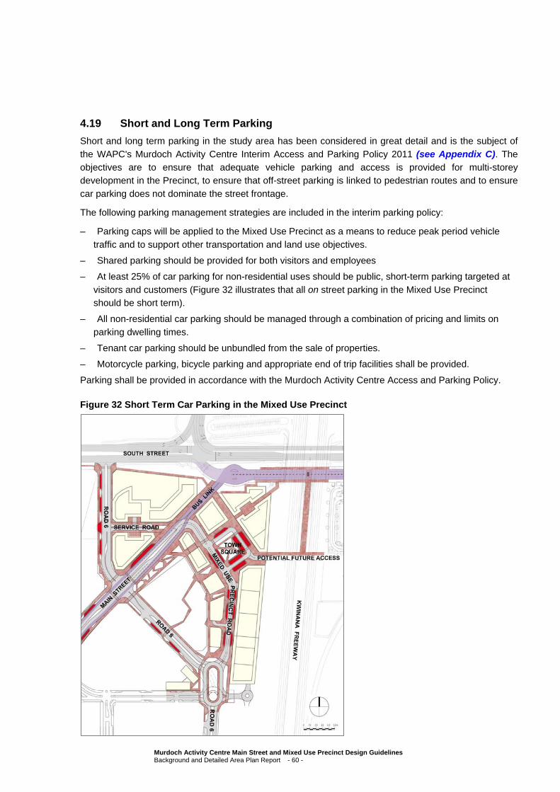
4.19 Short and Long Term Parking
Short and long term parking in the study area has been considered in great detail and is the subject of
the WAPC's Murdoch Activity Centre Interim Access and Parking Policy 2011 (see Appendix C). The objectives are to ensure that adequate vehicle parking and access is provided for multi-storey development in the Precinct, to ensure that off-street parking is linked to pedestrian routes and to ensure
car parking does not dominate the street frontage.
The following parking management strategies are included in the interim parking policy:
– Parking caps will be applied to the Mixed Use Precinct as a means to reduce peak period vehicle
traffic and to support other transportation and land use objectives.
– Shared parking should be provided for both visitors and employees
– At least 25% of car parking for non-residential uses should be public, short-term parking targeted at
visitors and customers (Figure 32 illustrates that all on street parking in the Mixed Use Precinct should be short term).
– All non-residential car parking should be managed through a combination of pricing and limits on
parking dwelling times.
– Tenant car parking should be unbundled from the sale of properties.
– Motorcycle parking, bicycle parking and appropriate end of trip facilities shall be provided.
Parking shall be provided in accordance with the Murdoch Activity Centre Access and Parking Policy.
Figure 32 Short Term Car Parking in the Mixed Use Precinct
Murdoch Activity Centre Main Street and Mixed Use Precinct Design Guidelines Background and Detailed Area Plan Report - 60 -

4.20 Proposed WSUD/Sustainability Measures
All new development should be designed to maximise passive solar principles for heating, cooling, ventilation and energy conservation. This can be achieved by designing for the climate of the area through correct building orientation, allowing access to natural light and achieving the correct thermal
performance of buildings and their materials.
New commercial development can achieve significant energy savings by controlling solar gain through glass, particularly from low angle sun from the east and west. In general, the larger the proportion of
glass on the surface of a building, the greater the impact on transmitted solar load. Energy savings can be achieved by plan shape and orientation of glass, use of special glass types and by shading. Some design factors are:
orientation – north and south orientated facades require less energy, minimise west and east facing glass;
providing adequate shading for all glass other than south facing glass;
including atriums (maximise daylight and cross ventilation)
thermal mass in commercial and residential developments to improve temperature stability;
natural cross-ventilation to reduce air conditioning needs;
low energy lamps and controls;
Building energy management systems;
incorporating of an upper floor roof/ceiling construction with a minimum thermal resistance value of R1.5; and
using materials of a colour which reflects rather than absorbs solar radiation, whilst ensuring reflective material avoids transferring heat to adjoining properties.
All buildings in the Mixed Use Precinct should meet minimum standards of four stars from the Green Building Council.
Stormwater and drainage in the precinct has been identified as an issue and should be carefully
considered with all developments being expected to maintain stormwater and drainage on site. Stormwater and drainage design should consider the broader Fiona Stanley Hospital Stormwater and Drainage Strategy as a guide.
Murdoch Activity Centre Main Street and Mixed Use Precinct Design Guidelines Background and Detailed Area Plan Report - 61 -
5. Proposed Staging of Development
Development of the Main Street and Mixed Use Precinct is being undertaken by several parties, including LandCorp, St John of God Hospital and Murdoch University. These developments are led by
market forces, existing funding sources, and commercial necessity. However, the Mixed Use Precinct requires some detailed consideration of staging. The Mixed Use Precinct is proposed to be developed at an approximate finished level of 27 AHD, up to 29 AHD. Existing ground levels in the area vary, but are
generally in the vicinity of 21-23 AHD.
It is proposed, in accordance with the objectives for the Mixed Use Precinct identified in Section 2.3, to develop 2 levels of parking beneath the finished Mixed Use Precinct level. The extent of the multiple
level parking will be determined in detail design, as the varying levels throughout the precinct require some detailed consideration, but generally it is expected that parking for the precinct will predominantly be located underground in parking structures set back behind retail and commercial frontages (parking to
be considered with the principles set out in Section 4.19).
Murdoch Activity Centre Main Street and Mixed Use Precinct Design Guidelines Background and Detailed Area Plan Report - 62 -
Appendix A
Murdoch Activity Centre Structure Plan
Murdoch Activity Centre Main Street and Mixed Use Precinct Design Guidelines Background and Detailed Area Plan Report - 63 -

121
Figure 16: Murdoch Activity Centre Structure Plan – Proposed Land Uses
Appendix B
Stakeholder Workshop Outcomes Report
Murdoch Activity Centre Main Street and Mixed Use Precinct Design Guidelines Background and Detailed Area Plan Report - 64 -
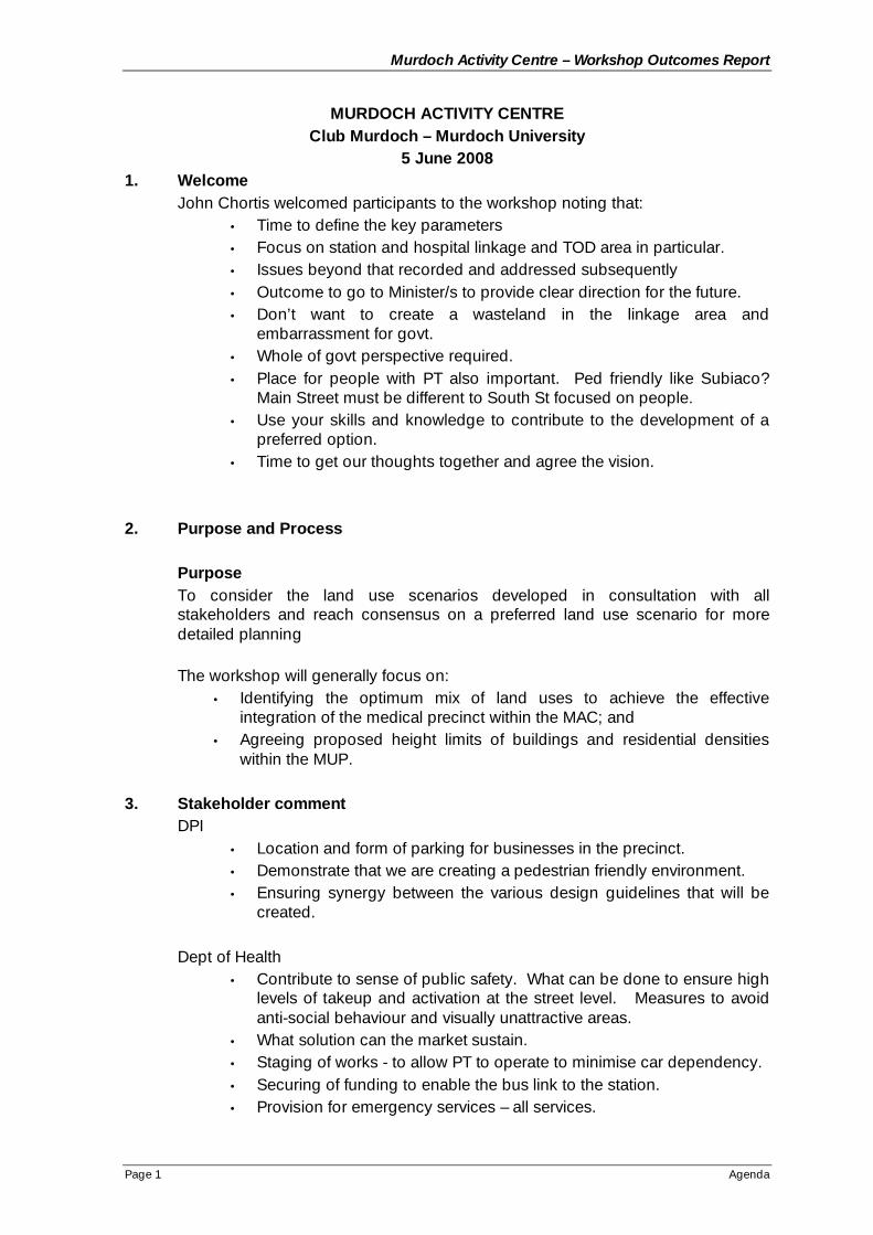
Murdoch Activity Centre – Workshop Outcomes Report
Page 1 Agenda
MURDOCH ACTIVITY CENTREClub Murdoch – Murdoch University
5 June 20081. Welcome
John Chortis welcomed participants to the workshop noting that:• Time to define the key parameters• Focus on station and hospital linkage and TOD area in particular.• Issues beyond that recorded and addressed subsequently• Outcome to go to Minister/s to provide clear direction for the future.• Don’t want to create a wasteland in the linkage area and
embarrassment for govt.• Whole of govt perspective required.• Place for people with PT also important. Ped friendly like Subiaco?
Main Street must be different to South St focused on people.• Use your skills and knowledge to contribute to the development of a
preferred option.• Time to get our thoughts together and agree the vision.
2. Purpose and Process
PurposeTo consider the land use scenarios developed in consultation with allstakeholders and reach consensus on a preferred land use scenario for moredetailed planning
The workshop will generally focus on:• Identifying the optimum mix of land uses to achieve the effective
integration of the medical precinct within the MAC; and• Agreeing proposed height limits of buildings and residential densities
within the MUP.
3. Stakeholder commentDPI
• Location and form of parking for businesses in the precinct.• Demonstrate that we are creating a pedestrian friendly environment.• Ensuring synergy between the various design guidelines that will be
created.
Dept of Health• Contribute to sense of public safety. What can be done to ensure high
levels of takeup and activation at the street level. Measures to avoidanti-social behaviour and visually unattractive areas.
• What solution can the market sustain.• Staging of works - to allow PT to operate to minimise car dependency.• Securing of funding to enable the bus link to the station.• Provision for emergency services – all services.
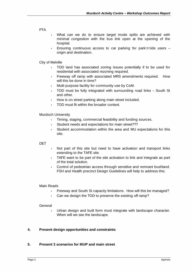
Murdoch Activity Centre – Workshop Outcomes Report
Page 2 Agenda
PTA• What can we do to ensure target mode splits are achieved with
minimal congestion with the bus link open at the opening of thehospital.
• Ensuring continuous access to car parking for park’n’ride users –origin and destination.
City of Melville• TOD land has associated zoning issues potentially if to be used for
residential with associated rezoning required.• Freeway off ramp with associated MRS amendments required. How
will this be done in time?• Multi purpose facility for community use by CoM.• TOD must be fully integrated with surrounding road links – South St
and other.• How is on street parking along main street included.• TOD must fit within the broader context.
Murdoch University• Timing, staging, commercial feasibility and funding sources.• Student needs and expectations for main street???• Student accommodation within the area and MU expectations for this
site.
DET• Not part of this site but need to have activation and transport links
extending to the TAFE site.• TAFE want to be part of the site activation to link and integrate as part
of the total solution.• Control of pedestrian access through sensitive and remnant bushland.
FSH and Health precinct Design Guidelines will help to address this.
Main Roads• Freeway and South St capacity limitations. How will this be managed?• Can we design the TOD to preserve the existing off ramp?
General• Urban design and built form must integrate with landscape character.
When will we see the landscape.
4. Present design opportunities and constraints
5. Present 3 scenarios for MUP and main street
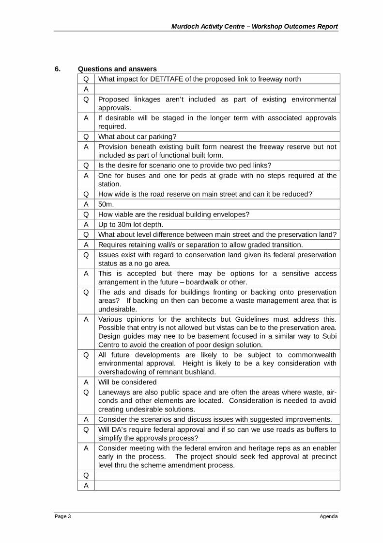
Murdoch Activity Centre – Workshop Outcomes Report
Page 3 Agenda
6. Questions and answersQ What impact for DET/TAFE of the proposed link to freeway northAQ Proposed linkages aren’t included as part of existing environmental
approvals.A If desirable will be staged in the longer term with associated approvals
required.Q What about car parking?A Provision beneath existing built form nearest the freeway reserve but not
included as part of functional built form.Q Is the desire for scenario one to provide two ped links?A One for buses and one for peds at grade with no steps required at the
station.Q How wide is the road reserve on main street and can it be reduced?A 50m.Q How viable are the residual building envelopes?A Up to 30m lot depth.Q What about level difference between main street and the preservation land?A Requires retaining wall/s or separation to allow graded transition.Q Issues exist with regard to conservation land given its federal preservation
status as a no go area.A This is accepted but there may be options for a sensitive access
arrangement in the future – boardwalk or other.Q The ads and disads for buildings fronting or backing onto preservation
areas? If backing on then can become a waste management area that isundesirable.
A Various opinions for the architects but Guidelines must address this.Possible that entry is not allowed but vistas can be to the preservation area.Design guides may nee to be basement focused in a similar way to SubiCentro to avoid the creation of poor design solution.
Q All future developments are likely to be subject to commonwealthenvironmental approval. Height is likely to be a key consideration withovershadowing of remnant bushland.
A Will be consideredQ Laneways are also public space and are often the areas where waste, air-
conds and other elements are located. Consideration is needed to avoidcreating undesirable solutions.
A Consider the scenarios and discuss issues with suggested improvements.Q Will DA’s require federal approval and if so can we use roads as buffers to
simplify the approvals process?A Consider meeting with the federal environ and heritage reps as an enabler
early in the process. The project should seek fed approval at precinctlevel thru the scheme amendment process.
QA
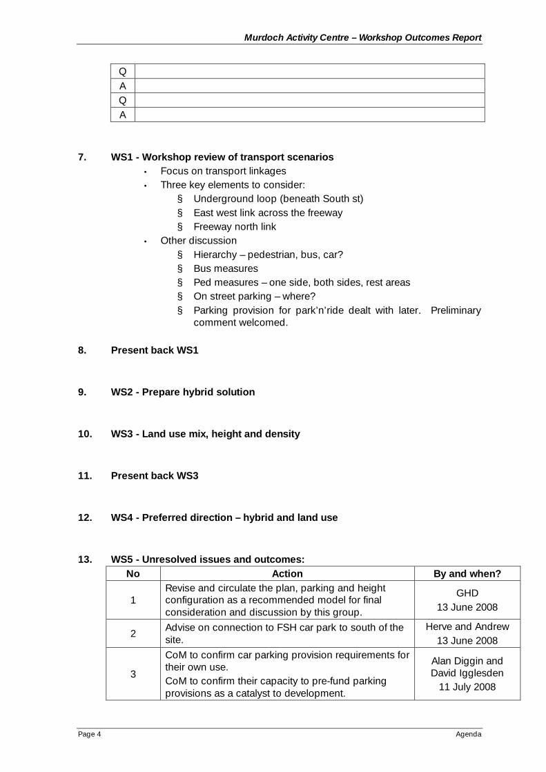
Murdoch Activity Centre – Workshop Outcomes Report
Page 4 Agenda
QAQA
7. WS1 - Workshop review of transport scenarios• Focus on transport linkages• Three key elements to consider:
§ Underground loop (beneath South st)§ East west link across the freeway§ Freeway north link
• Other discussion§ Hierarchy – pedestrian, bus, car?§ Bus measures§ Ped measures – one side, both sides, rest areas§ On street parking – where?§ Parking provision for park’n’ride dealt with later. Preliminary
comment welcomed.
8. Present back WS1
9. WS2 - Prepare hybrid solution
10. WS3 - Land use mix, height and density
11. Present back WS3
12. WS4 - Preferred direction – hybrid and land use
13. WS5 - Unresolved issues and outcomes:No Action By and when?
1Revise and circulate the plan, parking and heightconfiguration as a recommended model for finalconsideration and discussion by this group.
GHD13 June 2008
2Advise on connection to FSH car park to south of thesite.
Herve and Andrew13 June 2008
3
CoM to confirm car parking provision requirements fortheir own use.CoM to confirm their capacity to pre-fund parkingprovisions as a catalyst to development.
Alan Diggin andDavid Igglesden
11 July 2008
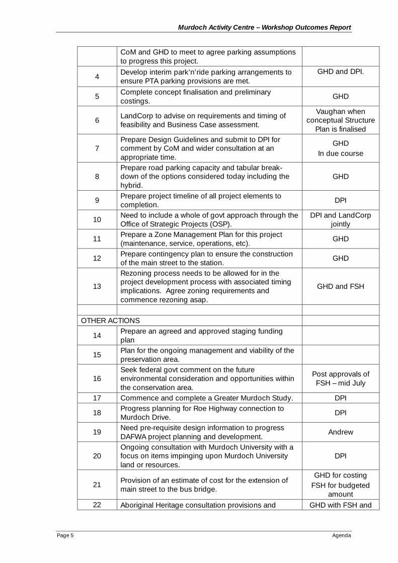
Murdoch Activity Centre – Workshop Outcomes Report
Page 5 Agenda
CoM and GHD to meet to agree parking assumptionsto progress this project.
4Develop interim park’n’ride parking arrangements toensure PTA parking provisions are met.
GHD and DPI.
5 Complete concept finalisation and preliminarycostings.
GHD
6LandCorp to advise on requirements and timing offeasibility and Business Case assessment.
Vaughan whenconceptual Structure
Plan is finalised
7Prepare Design Guidelines and submit to DPI forcomment by CoM and wider consultation at anappropriate time.
GHDIn due course
8Prepare road parking capacity and tabular break-down of the options considered today including thehybrid.
GHD
9 Prepare project timeline of all project elements tocompletion.
DPI
10 Need to include a whole of govt approach through theOffice of Strategic Projects (OSP).
DPI and LandCorpjointly
11 Prepare a Zone Management Plan for this project(maintenance, service, operations, etc).
GHD
12 Prepare contingency plan to ensure the constructionof the main street to the station.
GHD
13
Rezoning process needs to be allowed for in theproject development process with associated timingimplications. Agree zoning requirements andcommence rezoning asap.
GHD and FSH
OTHER ACTIONS
14 Prepare an agreed and approved staging fundingplan
15 Plan for the ongoing management and viability of thepreservation area.
16Seek federal govt comment on the futureenvironmental consideration and opportunities withinthe conservation area.
Post approvals ofFSH – mid July
17 Commence and complete a Greater Murdoch Study. DPI
18 Progress planning for Roe Highway connection toMurdoch Drive.
DPI
19 Need pre-requisite design information to progressDAFWA project planning and development.
Andrew
20Ongoing consultation with Murdoch University with afocus on items impinging upon Murdoch Universityland or resources.
DPI
21 Provision of an estimate of cost for the extension ofmain street to the bus bridge.
GHD for costingFSH for budgeted
amount22 Aboriginal Heritage consultation provisions and GHD with FSH and

Murdoch Activity Centre – Workshop Outcomes Report
Page 6 Agenda
potential gaps that may result in project delays.State and federal environment provisions andpotential gaps that may result in project delays.
PTA input
23 Include provision for future pedestrian overpasslinkages between public and private facilities.
24Agree planting species for inclusion as part of thelandscaping provisions in the public domain.
GHD Hassell andMurdoch Uni (Lisa
Spiers)
25Prepare and include long and cross sections forfurther consideration and discussion as importantsupporting information.
Close at 5:00pm
Appendix A – Workshop PresentationAppendix B – Preferred ElementsAppendix C – Bulk and scale

Murdoch Activity Centre Main Street and Mixed Use Precinct Design Guidelines – Stakeholder Workshop June 5th, 2008
MURDOCH ACTIVITY CENTRE MAINMURDOCH ACTIVITY CENTRE MAINSTREET AND MIXED USE PRECINCTSTREET AND MIXED USE PRECINCT
DESIGN GUIDELINESDESIGN GUIDELINES
Stakeholder Workshop June 5Stakeholder Workshop June 5thth, 2008, 2008
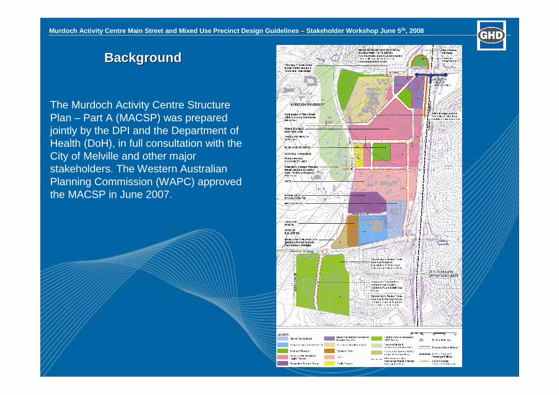
Murdoch Activity Centre Main Street and Mixed Use Precinct Design Guidelines – Stakeholder Workshop June 5th, 2008
BackgroundBackground
The Murdoch Activity Centre StructurePlan – Part A (MACSP) was preparedjointly by the DPI and the Department ofHealth (DoH), in full consultation with theCity of Melville and other majorstakeholders. The Western AustralianPlanning Commission (WAPC) approvedthe MACSP in June 2007.
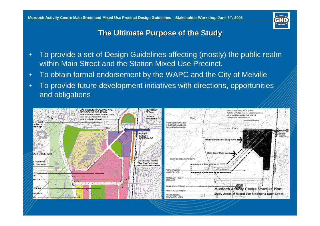
Murdoch Activity Centre Main Street and Mixed Use Precinct Design Guidelines – Stakeholder Workshop June 5th, 2008
The Ultimate Purpose of the StudyThe Ultimate Purpose of the Study
• To provide a set of Design Guidelines affecting (mostly) the public realmwithin Main Street and the Station Mixed Use Precinct.
• To obtain formal endorsement by the WAPC and the City of Melville• To provide future development initiatives with directions, opportunities
and obligations

Murdoch Activity Centre Main Street and Mixed Use Precinct Design Guidelines – Stakeholder Workshop June 5th, 2008
Workshop ThemesWorkshop Themes
• Urban Structure• Street Layout• Mix and Distribution of Land
Uses• Street Design• Train Station and Public Transport
• Station and Interchangeenvironment
• Passenger facilities• Public Spaces
• High quality public space• Sense of Place• Safety and Security
• Building Design• Environmental
Sustainability• Future Proofing
• Higher DensityHousing• Density
Opportunities• Building Design
• Car Parking• On-street car parking• Off-street car parking

Murdoch Activity Centre Main Street and Mixed Use Precinct Design Guidelines – Stakeholder Workshop June 5th, 2008
Opportunities and ConstraintsOpportunities and Constraints
Opportunities• A Clean Slate… very little existing
development to ‘redevelop’• To achieve the best possible built
outcome that will be suitable into thefuture
• To bring together multiplestakeholders to achieve that outcomein a collaborative process
• To achieve a true TOD/Activity Centrethat promotes public transport overprivate transport use
• To achieve a sustainable and vibranturban community built on substantialemployment, social and environmentalattractors
• To achieve a high density precinct witha mix of land uses and housing types
Constraints• The northern most corner of the FSH
site will sit at approximately 23RL,whilst the bus station sits at 26.5RL,and the rail access at 29RL.
• PTA require existing park and ridenumbers to be maintained
• Traffic through the precinct is expectedto be substantial, and there areseveral areas of traffic conflict in thecurrent preliminary design
• The majority of the masterplanning forthe FSH has already been undertaken,and this project has limited opportunityto influence outcomes along the southside of Main Street
• Various infrastructure

Murdoch Activity Centre Main Street and Mixed Use Precinct Design Guidelines – Stakeholder Workshop June 5th, 2008
• Land Uses• Specialty shops, supermarket,
liquor stores• Restaurants• Offices• Residential• Consulting rooms
• Street Design• Main entries, secondary
alignments• Building Heights
• Station
• Public Spaces• High quality public space• Sense of Place• Safety and Security
• Higher Density Housing• R160?• Apartment types/variety
• Car Parking• On-street car parking• Off-street car parking
PromptsPrompts
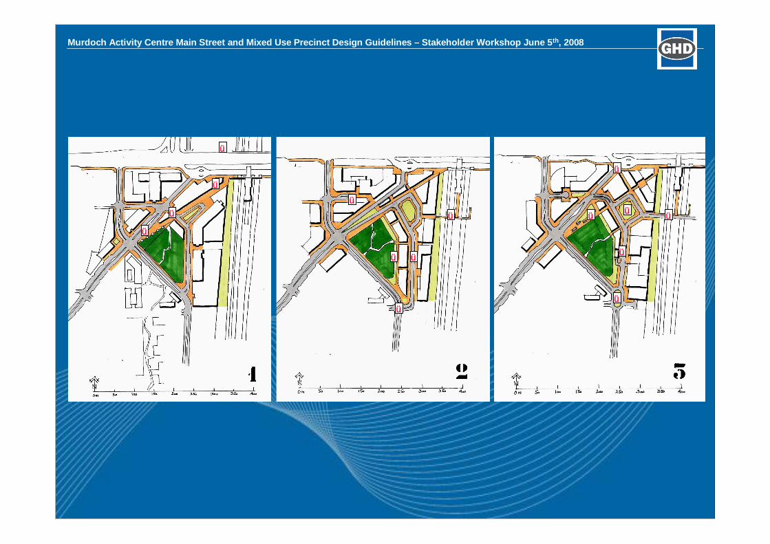
Murdoch Activity Centre Main Street and Mixed Use Precinct Design Guidelines –Stakeholder Workshop June 5th, 2008
ü
ü
ü
ü
ü
ü
ü
ü
üü
üü
ü
ü
ü
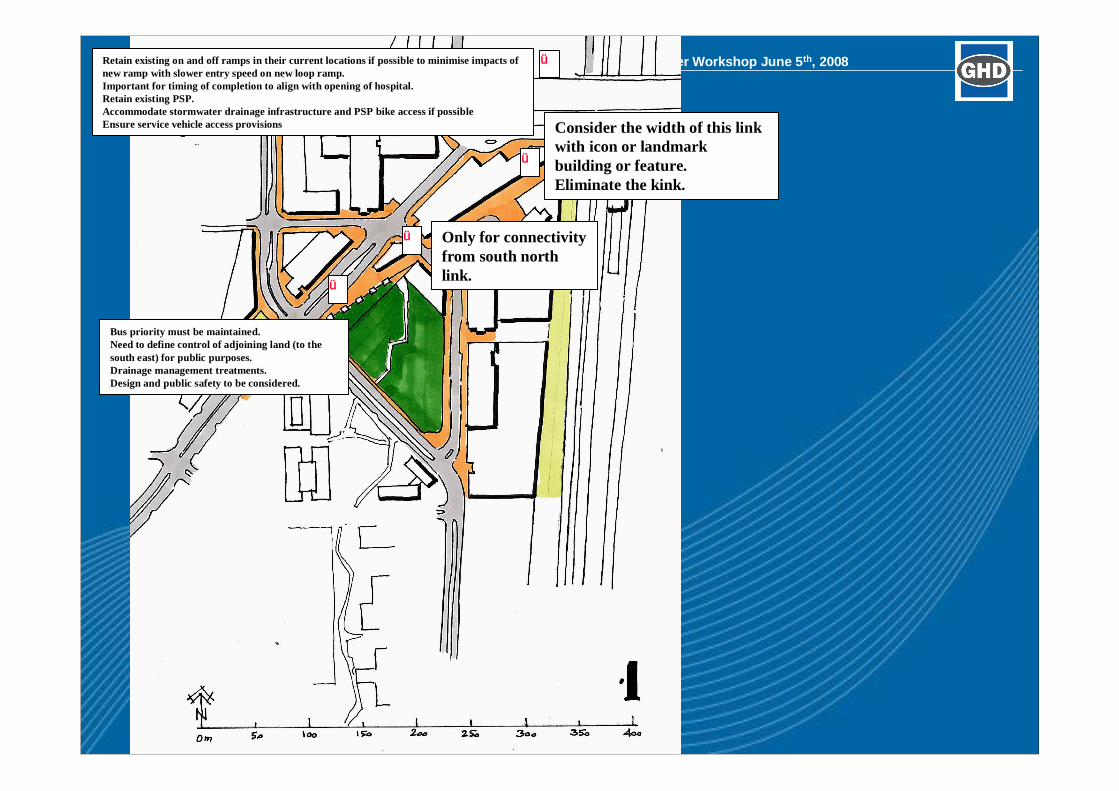
Murdoch Activity Centre Main Street and Mixed Use Precinct Design Guidelines –Stakeholder Workshop June 5th, 2008
ü
ü
ü
ü
Retain existing on and off ramps in their current locations if possible to minimise impacts ofnew ramp with slower entry speed on new loop ramp.Important for timing of completion to align with opening of hospital.Retain existing PSP.Accommodate stormwater drainage infrastructure and PSP bike access if possibleEnsure service vehicle access provisions
Bus priority must be maintained.Need to define control of adjoining land (to thesouth east) for public purposes.Drainage management treatments.Design and public safety to be considered.
Only for connectivityfrom south northlink.
Consider the width of this linkwith icon or landmarkbuilding or feature.Eliminate the kink.
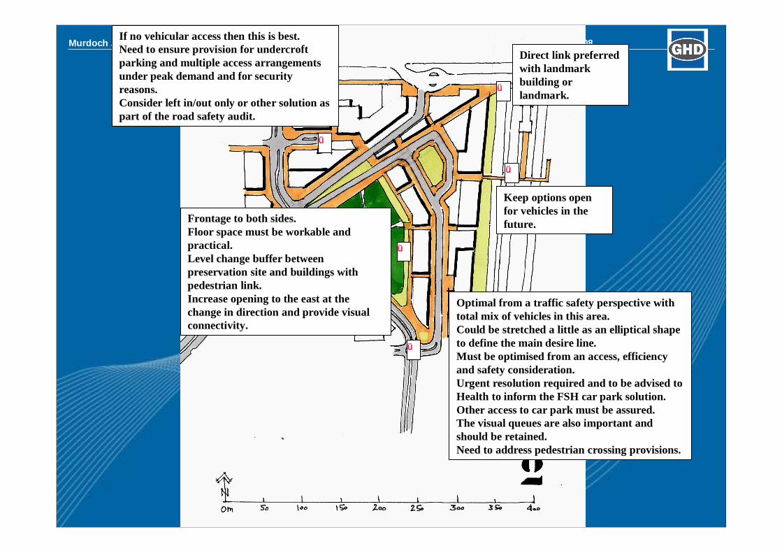
Murdoch Activity Centre Main Street and Mixed Use Precinct Design Guidelines –Stakeholder Workshop June 5th, 2008
ü
ü
ü
ü
ü
Direct link preferredwith landmarkbuilding orlandmark.
Keep options openfor vehicles in thefuture.Frontage to both sides.
Floor space must be workable andpractical.Level change buffer betweenpreservation site and buildings withpedestrian link.Increase opening to the east at thechange in direction and provide visualconnectivity.
Optimal from a traffic safety perspective withtotal mix of vehicles in this area.Could be stretched a little as an elliptical shapeto define the main desire line.Must be optimised from an access, efficiencyand safety consideration.Urgent resolution required and to be advised toHealth to inform the FSH car park solution.Other access to car park must be assured.The visual queues are also important andshould be retained.Need to address pedestrian crossing provisions.
If no vehicular access then this is best.Need to ensure provision for undercroftparking and multiple access arrangementsunder peak demand and for securityreasons.Consider left in/out only or other solution aspart of the road safety audit.
Murdoch Activity Centre Main Street and Mixed Use Precinct Design Guidelines –Stakeholder Workshop June 5th, 2008
ü
üü
ü
Optimal from a traffic safetyperspective with total mix ofvehicles in this area.Ensure hospital access to car parkwith footpath linkages required.Provide pelican crossingopportunities and key locations
ü
Visual link good and to bemaintained if possible forlegibility.Are these viable floor platesizes? What aboutfeasibility?
Transition may be mix ofsmaller retaining walls.Civic space opportunity tomaintain visual links linearPOS.
Best town square solution.Extend or modify townsquare to link with greenspace.
Keep options openfor vehicles in thefuture.
Murdoch Activity Centre Main Street and Mixed Use Precinct Design Guidelines –Stakeholder Workshop June 5th, 2008
SCENARIOSSCENARIOS ––Scenario 1Scenario 1The 3The 3rdrd DimensionDimension
Murdoch Activity Centre Main Street and Mixed Use Precinct Design Guidelines –Stakeholder Workshop June 5th, 2008
SCENARIOSSCENARIOS ––Scenario 1Scenario 1The 3The 3rdrd DimensionDimension

Murdoch Activity Centre Main Street and Mixed Use Precinct Design Guidelines –Stakeholder Workshop June 5th, 2008
SCENARIOSSCENARIOS ––Scenario 2Scenario 2The 3The 3rdrd DimensionDimension

Murdoch Activity Centre Main Street and Mixed Use Precinct Design Guidelines –Stakeholder Workshop June 5th, 2008
SCENARIOSSCENARIOS ––Scenario 2Scenario 2The 3The 3rdrd DimensionDimension
Murdoch Activity Centre Main Street and Mixed Use Precinct Design Guidelines –Stakeholder Workshop June 5th, 2008
SCENARIOSSCENARIOS ––Scenario 3Scenario 3The 3The 3rdrd DimensionDimension

Murdoch Activity Centre Main Street and Mixed Use Precinct Design Guidelines –Stakeholder Workshop June 5th, 2008
SCENARIOSSCENARIOS ––Scenario 3Scenario 3The 3The 3rdrd DimensionDimension
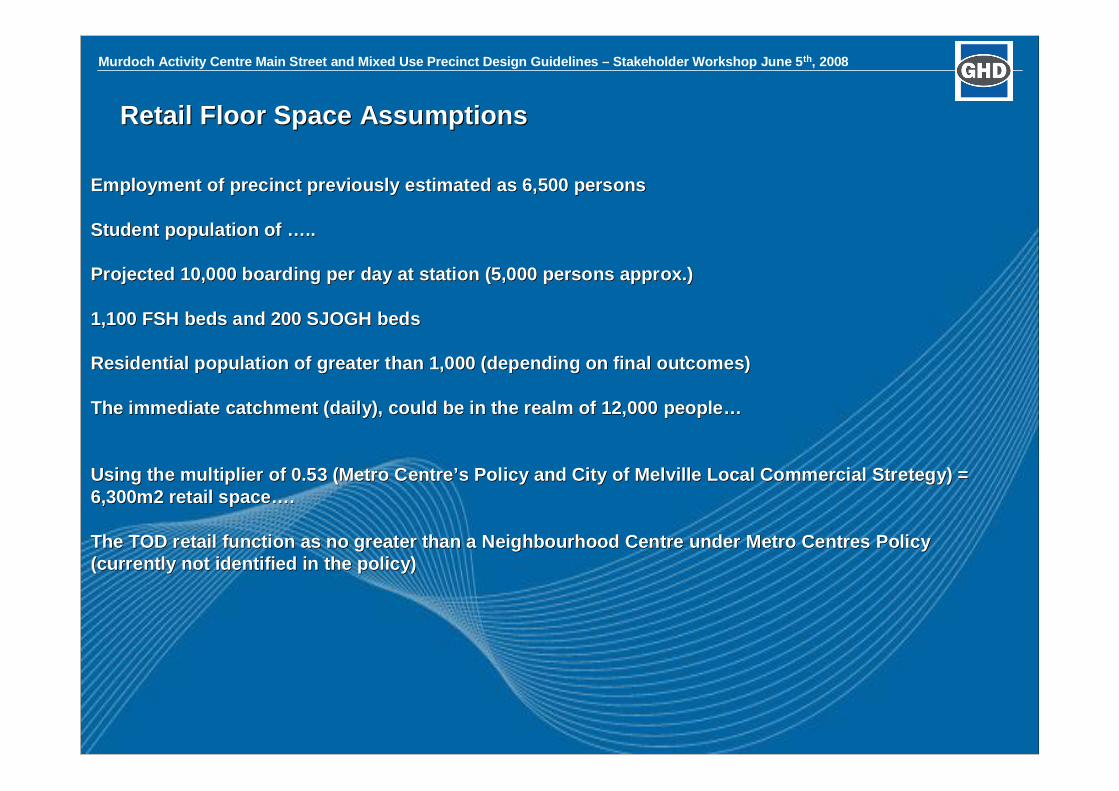
Murdoch Activity Centre Main Street and Mixed Use Precinct Design Guidelines –Stakeholder Workshop June 5th, 2008
Retail Floor Space AssumptionsRetail Floor Space Assumptions
Employment of precinct previously estimated as 6,500 personsEmployment of precinct previously estimated as 6,500 persons
Student population ofStudent population of …… ....
Projected 10,000 boarding per day at station (5,000 persons apprProjected 10,000 boarding per day at station (5,000 persons approx.)ox.)
1,100 FSH beds and 200 SJOGH beds1,100 FSH beds and 200 SJOGH beds
Residential population of greater than 1,000 (depending on finalResidential population of greater than 1,000 (depending on final outcomes)outcomes)
The immediate catchment (daily), could be in the realm of 12,000The immediate catchment (daily), could be in the realm of 12,000 peoplepeople……
Using the multiplier of 0.53 (Metro CentreUsing the multiplier of 0.53 (Metro Centre’’s Policy and City of Melville Local Commercials Policy and City of Melville Local Commercial StretegyStretegy) =) =6,300m2 retail space6,300m2 retail space…… ..
The TOD retail function as no greater than aThe TOD retail function as no greater than a NeighbourhoodNeighbourhood Centre under MetroCentre under Metro CentresCentres PolicyPolicy(currently not identified in the policy)(currently not identified in the policy)

Murdoch Activity Centre Main Street and Mixed Use Precinct Design Guidelines Background and Detailed Area Plan Report - 65 -
Appendix C
WAPC Murdoch Activity Centre Interim Access and Parking Policy 2011

WAPC RESOLUTION:
That the Western Australian Planning Commission resolves to: 1. Adopt the draft "Murdoch Activity Centre Access and Parking Policy as a
guide for the future transport planning for the MAC Precinct until the proposed State Planning Policy (SPP) - Metropolitan Centres Parking has been gazetted and the draft Access and Parking Policy can be updated and modified to be consistent with the SPP.
2. Adopt and apply to subdivisions and development applications the planning principles outlined in Attachment 1 to planning approvals within the Murdoch Activity Centre (MAC).
3. Adopt and apply to development applications a maximum parking provision (parking cap) for the MAC of 17,500 bays as allocated for each sub-precinct landowner in table 1 and Map 1 and only support subdivisions that maintain ownership and control of parking with the original sub-precinct owner.
1
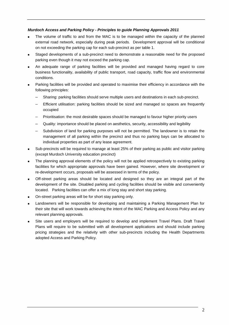
Murdoch Access and Parking Policy - Principles to guide Planning Approvals 2011
The volume of traffic to and from the MAC is to be managed within the capacity of the planned
external road network, especially during peak periods. Development approval will be conditional
on not exceeding the parking cap for each sub-precinct as per table 1.
Staged developments of a sub-precinct need to demonstrate a reasonable need for the proposed
parking even though it may not exceed the parking cap.
An adequate range of parking facilities will be provided and managed having regard to core
business functionality, availability of public transport, road capacity, traffic flow and environmental
conditions.
Parking facilities will be provided and operated to maximise their efficiency in accordance with the
following principles:
– Sharing: parking facilities should serve multiple users and destinations in each sub-precinct.
– Efficient utilisation: parking facilities should be sized and managed so spaces are frequently
occupied
– Prioritisation: the most desirable spaces should be managed to favour higher priority users
– Quality: importance should be placed on aesthetics, security, accessibility and legibility
– Subdivision of land for parking purposes will not be permitted. The landowner is to retain the
management of all parking within the precinct and thus no parking bays can be allocated to
individual properties as part of any lease agreement.
Sub-precincts will be required to manage at least 25% of their parking as public and visitor parking
(except Murdoch University education precinct)
The planning approval elements of the policy will not be applied retrospectively to existing parking
facilities for which appropriate approvals have been gained. However, where site development or
re-development occurs, proposals will be assessed in terms of the policy.
Off-street parking areas should be located and designed so they are an integral part of the
development of the site. Disabled parking and cycling facilities should be visible and conveniently
located. Parking facilities can offer a mix of long stay and short stay parking.
On-street parking areas will be for short stay parking only.
Landowners will be responsible for developing and maintaining a Parking Management Plan for
their site that will work towards achieving the intent of the MAC Parking and Access Policy and any
relevant planning approvals.
Site users and employers will be required to develop and implement Travel Plans. Draft Travel
Plans will require to be submitted with all development applications and should include parking
pricing strategies and the relativity with other sub-precincts including the Health Departments
adopted Access and Parking Policy.
2
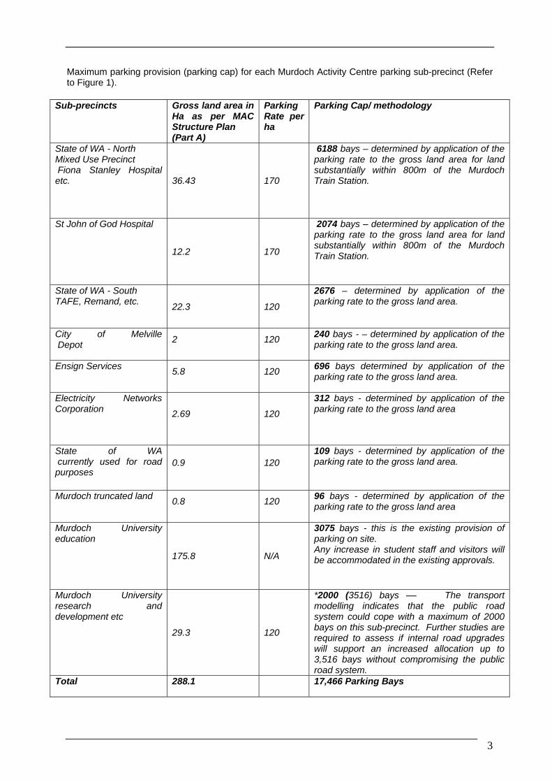
Maximum parking provision (parking cap) for each Murdoch Activity Centre parking sub-precinct (Refer to Figure 1).
Sub-precincts Gross land area in Ha as per MAC Structure Plan (Part A)
Parking Rate per ha
Parking Cap/ methodology
State of WA - North Mixed Use Precinct Fiona Stanley Hospital etc. 36.43 170
6188 bays – determined by application of the parking rate to the gross land area for land substantially within 800m of the Murdoch Train Station.
St John of God Hospital
12.2 170
2074 bays – determined by application of the parking rate to the gross land area for land substantially within 800m of the Murdoch Train Station.
State of WA - South TAFE, Remand, etc.
22.3 120
2676 – determined by application of the parking rate to the gross land area.
City of Melville Depot
2 120 240 bays - – determined by application of the parking rate to the gross land area.
Ensign Services 5.8 120
696 bays determined by application of the parking rate to the gross land area.
Electricity Networks Corporation 2.69 120
312 bays - determined by application of the parking rate to the gross land area
State of WA currently used for road purposes
0.9 120 109 bays - determined by application of the parking rate to the gross land area.
Murdoch truncated land 0.8 120
96 bays - determined by application of the parking rate to the gross land area
Murdoch University education
175.8 N/A
3075 bays - this is the existing provision of parking on site. Any increase in student staff and visitors will be accommodated in the existing approvals.
Murdoch University research and development etc
29.3 120
*2000 (3516) bays –– The transport modelling indicates that the public road system could cope with a maximum of 2000 bays on this sub-precinct. Further studies are required to assess if internal road upgrades will support an increased allocation up to 3,516 bays without compromising the public road system.
Total 288.1 17,466 Parking Bays
3

*Based on the ARRB report MAC - Assessment of Transport Impacts that determined the proposed road network capacity
4
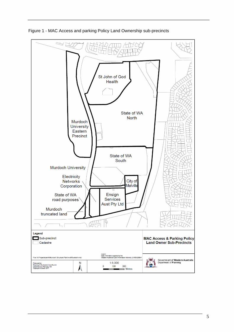
Figure 1 - MAC Access and parking Policy Land Ownership sub-precincts
5