multiscale habitat preferences and selectivity in bats ... · multiscale habitat preferences and...
TRANSCRIPT
Tania Rose Esteban (2015) Multiscale habitat associations in bats
P a g e | 1
Multiscale habitat preferences and selectivity in bats
across urban to rural landscapes
Tania R.E –Esteban
School of Biology, Faculty of Biological Science, University of Leeds, UK, LS2 9JT
Student ID: 200708050
Zoology
Professor John Altringham
Faculty of Biological Sciences, University of Leeds, LS2 9JT

Tania Rose Esteban (2015) Multiscale habitat associations in bats
P a g e | 2
Table of Contents
1. ABSTRACT…………………………………………………………………………………….…..3
2. INTRODUCTION…….…………………………………………………………………………….3
2.1. Urban growth …………………………………………………………………..…………....3
2.2. Value of bats ……………………………………………………………………..………....4
2.3. Importance and impacts of urban landscapes on bats………………….……..…….….4
2.4. Other anthropogenic threats facing bats……………………………………………..…...5
2.5. Importance of species-habitat associations and Habitat Suitability Modelling……..…6
2.6. Aims and predictions …………………………………………………………..……….…..6
3. METHODS ……………………..……………………………………………………………...…..7
3.1. Area of study ………………………………………………………………..…………….…7
3.2. Collection of species data ………………………………………………………..….…..…8
3.3. Data conversion ………………………………………………….……………………..…..8
3.4. Environmental geographic variables and ArcGIS …………………………………...….9
3.5. SPSS and statistical analysis of data……………………..………………..……..….….11
4. RESULTS.…………………………………………………………………..…………………….11
4.1. Abundance and distribution.………………………………………………………………12
4.2. Distance to habitat features (EVGs)…………….……………………………………….13
4.3. Percentage cover of habitat features at two spatial scales……………………………14
4.4. Interspecies comparisons for distances to EGVs……………………………………….18
4.5. Interspecies comparisons for percentage cover of habitat features ………………....18
4.6. Spearman’s Rank correlation……………………………………………………………..19
5. DISCUSSION …………………………………………..…………………………………….....20
5.1. Distribution of bat species across West and North Yorkshire………..……..………...20
5.2. Bat presence and proximity relationships to habitat features……..…….………….....21
5.3. Is bat presence driven by percentage cover of buildings, woodland or water?.....…22
5.4. Correlations and interspecies habitat preferences for distance and percentage cover
of EGVs………………………………………………………………………………………..….23
5.5. Evaluating methods and suggested further research…………………………..……..24
5.6. Conclusion…….……………..…………………………………………………………… 25
6.7. Ethics…………………………………………………………………………………….…26
6. ACKNOWLEDGEMENTS………………………………………………………………………26
7. REFERENCES……………………….…………………………………………………………26
8. APPENDIX…………………………………………………………………………………..…..29
Tania Rose Esteban (2015) Multiscale habitat associations in bats
P a g e | 3
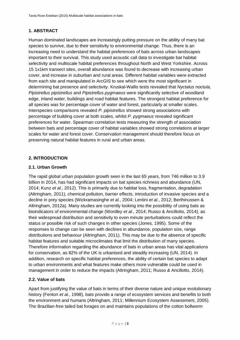
1. ABSTRACT
Human dominated landscapes are increasingly putting pressure on the ability of many bat
species to survive, due to their sensitivity to environmental change. Thus, there is an
increasing need to understand the habitat preferences of bats across urban landscapes
important to their survival. This study used acoustic call data to investigate bat habitat
selectivity and multiscale habitat preferences throughout North and West Yorkshire. Across
15 1x1km transect sites, overall abundance was found to decrease with increasing urban
cover, and increase in suburban and rural areas. Different habitat variables were extracted
from each site and manipulated in ArcGIS to see which were the most significant in
determining bat presence and selectivity. Kruskal-Wallis tests revealed that Nyctalus noctula,
Pipistrellus pipistrellus and Pipistrellus pygmaeus were significantly selective of woodland
edge, inland water, buildings and road habitat features. The strongest habitat preference for
all species was for percentage cover of water and forest, particularly at smaller scales.
Interspecies comparisons revealed P. pipistrellus showed strong associations with
percentage of building cover at both scales, whilst P. pygmaeus revealed significant
preferences for water. Spearman correlation tests measuring the strength of association
between bats and percentage cover of habitat variables showed strong correlations at larger
scales for water and forest cover. Conservation management should therefore focus on
preserving natural habitat features in rural and urban areas.
2. INTRODUCTION
2.1. Urban Growth
The rapid global urban population growth seen in the last 65 years, from 746 million to 3.9
billion in 2014, has had significant impacts on bat species richness and abundance (UN,
2014; Kunz et al., 2012). This is primarily due to habitat loss, fragmentation, degradation
(Altringham, 2011), chemical pollution, barrier effects, introduction of invasive species and a
decline in prey species (Wickramasinghe et al., 2004; Lentini et al., 2012; Berthinussen &
Altringham, 2012a). Many studies are currently looking into the possibility of using bats as
bioindicators of environmental change (Wordley et al., 2014; Russo & Ancillotto, 2014), as
their widespread distribution and sensitivity to even minute perturbations could reflect the
status or possible risk of such changes in other species (Jones, 1995). Some of the
responses to change can be seen with declines in abundance, population size, range
distributions and behaviour (Altringham, 2011). This may be due to the absence of specific
habitat features and suitable microclimates that limit the distribution of many species.
Therefore information regarding the abundance of bats in urban areas has vital applications
for conservation, as 82% of the UK is urbanised and steadily increasing (UN, 2014). In
addition, research on specific habitat preferences, the ability of certain bat species to adapt
to urban environments and what features make others more vulnerable could be used in
management in order to reduce the impacts (Altringham, 2011; Russo & Ancillotto, 2014).
2.2. Value of bats
Apart from justifying the value of bats in terms of their diverse nature and unique evolutionary
history (Fenton et al., 1998), bats provide a range of ecosystem services and benefits to both
the environment and humans (Altringham, 2011; Millennium Ecosystem Assessment, 2005).
The Brazilian-free tailed bat forages on and maintains populations of the cotton bollworm

Tania Rose Esteban (2015) Multiscale habitat associations in bats
P a g e | 4
insect pest, saving the US economy over $23 billion dollars in terms of preventative damage
to cotton and reduced pesticide use (Cleveland et al., 2006). In Asian markets, over 70% of
the fruit sold is pollinated or seed dispersed by bats, in particular the Durian fruit which is
worth $2 billion annually (Kunz et al., 2012; Altringham, 2011). Guano is a source of high
phosphorus and nitrogen, and one of the primary limiting nutrients of plant life. Duchamp et
al. (2010) studied the potential benefits of the ‘pepper shaker-effect,’ a hypothesis where
bats flying from nutrient-rich regions to nutrient-poor habitats redistribute the guano and act
as mobile fertilisers.
Ecotourism also boosts the economy, as seen in Congress Avenue, Texas, generating $12
million annually (Pennisi et al., 2004). Medicine is also derived from the Vampire bat’s
salivary enzyme, desmoteplase, which acts as an anticoagulant for post-ischemic stroke
patients (Furlan et al., 2006). It has been found to extend the time required to administer
tissue plasminogen activator during the post-stroke period from 3 to 9 hours (Schleuning,
2000). Other aspects of bat biology providing benefits to humans include the development of
the ©UltraCane, a device that enables the blind to detect oncoming objects. Developed by
researchers at the University of Leeds, it was based on the echolocation calls of bats and
has helped thousands of visually impaired people (Scheggi et al., 2014).
2.3. Importance and impacts of an urban landscape on bats
Urban foraging
Each bat is perfectly adapted to each habitat in terms of wing morphology, diet, ecological
niche, echolocation call, hibernacula and behaviour (Altringham, 2011; Threfall et al., 2008).
The effects of particular habitat features on bats differs, as each specie uses the landscape
differently (Altringham, 2011; Coleman & Barclay, 2011). Some exhibit behavioural plasticity
and can adapt to urban environments, enabling them to effectively exploit their habitat
without the disruption of roads, light pollution or buildings (Russo & Ancillotto, 2014; Stone et
al., 2009). They are known as urban adaptors or synurbic species (Kerth & Melber, 2009;
Russo & Ancillotto, 2014). This has frequently been seen in bats with long, narrow wing
morphology with a high wing loading, as open air foragers are largely unaffected by
urbanisation (Norbeg & Rayner, 1987). The ability of synanthropic bats to dominate urban
foraging areas can be problematic for the less well adapted species (Silvis et al., 2014,
Russo & Ancillotto, 2014), and may result in competition. Populations of Rhinolophus
hipposideros in Wales may be in decline be due to the expansion of Pipistrellus pipistrellus,
which have increased as a result of greater feeding efficiency provided by artificial lights
normally avoided by the lesser horseshoe bat (Warren et al., 2000; Lacoeuilhe et al., 2014;
Arlettaz et al., 2000).
Water in urban areas
Bats are vulnerable to evaporative water loss as a consequence of their morphology and
large surface area to volume ratio (Razgour et al., 2010). Within urban areas, open artificial
sources such as ponds, ditches and swimming pools provide bats with fundamental
opportunities to drink and forage. Certain species show preferences over these larger, less
cluttered and open bodies of water (Siemers & Schaub, 2011). The reduction in pulse-echo
overlap, ability to detect spectral shift and high insect abundance over still water sources can
attract large numbers of bats to urban and modified sites (Altringham, 2011). Such examples

Tania Rose Esteban (2015) Multiscale habitat associations in bats
P a g e | 5
can be seen in North Carolina, where studies looking at the importance of managed water
bodies over natural wetlands revealed significantly higher bat activity by heliponds, despite
equal densities of insects at both sites (Vindigni et al., 2009). Similarly, studies on Greek
islands have shown that bats will also use artificial water sources such as swimming pools
due to the lack of natural sources in such arid habitats, with minimal annual rainfall (Davy et
al., 2007).
Urban threats and barriers
The impact of roads on bats was largely overlooked until a hypothesized extinction model
was proposed by Forman et al., (2003). Habitat destruction by their construction reduces
foraging and roosting habitat; vital resources key to a bats survival (Bellamy et al., 2013).
This can lead to a reduction in habitat quality due to the addition of chemical, acoustic and
light pollution (Altringham, 2011). This has been known to alter and negatively impact the
foraging ability of Myotis myotis via acoustic pollution from incoming traffic, where the bat is
unable to detect spectral shifts in its ground dwelling arthropod prey (Siemers & Schaub,
2011). A large number of collisions occur with low flying species (<0-4m), and studies
investigating the effectiveness of mitigation strategies (bat gantries), revealed that 84% of the
bats acoustically surveyed were at risk crossing the roads at unsafe heights (Altringham,
2011), despite their manoeuvrability (Berthinussen & Altringham, 2012b).
The barrier effect is also problematic, as the disruption of connected core habitats reduces
the range and size of a bats habitat (Altringham, 2011). When landscape connectivity no
longer facilitates the movement and passage of bats, this can lead to reduced survival of
smaller, genetically isolated populations restricted to patches. This is due to their habitat-
specific preferences and flight and echolocation abilities (Jackson & Fahrig, 2011). Higher
flying species such as Noctule bats are less affected by the expansion of roads, due to their
fast open air foraging and greater commuting distances (Jung & Kalko, 2012), whereas
slower, gleaning species are more sensitive to such barriers (Berthinussen & Altringham,
2012a). The vagility and mobile flying capabilities of bats was thought to enable them to
avoid such threats (Stanley et al., 2003). However, research has revealed a significant
relationship between the decrease in bat activity and diversity with closer proximity to roads,
providing the first conclusive evidence of their effect on bats in the UK (Berthinussen &
Altringham, 2012a).
2.4. Other anthropogenic threats facing bats
The threat of turbines has been little studied and understood in bats (Altringham, 2011;
Cryan & Barclay, 2009). One recent study manipulating wind turbines and using thermal
imaging cameras concluded that blade rotation speed did not influence the way in which the
bats interacted with the structure (Cryan et al., 2014). The best studies have included more
rigorous empirical data and methodology, revealing that 75% of tree roosting species in
North America were among those bats affected and killed by turbines (Altringham, 2011).
Other threat to bats include anthropogenic climate change, as global temperatures continue
to rise with possible increases of 5.0-6.4˚C by 2081-2100 (IPCC, 2014). Despite their ability
to fly, migrate and possibly expand their ranges to higher latitudes, their survival ultimately
depends on their adaptability (Altringham, 2011) and state of the environment they are driven
to (La Val, 2004). If the habitat is fragmented and lacking specific habitat features, specialist
species will be more at risk from extinction (Lopez-Roig & Serra-Cobo, 2014; Altringham,
2011). Evidence for northerly shifts in species distribution has been recorded from bat
Tania Rose Esteban (2015) Multiscale habitat associations in bats
P a g e | 6
captures between 1973-1999 in Monteverde, Costa Rica (La Val (2004). Rebello (2010) used
IPCC climate change scenarios to predict the future biogeographical distribution of 28
European bat species, where Boreal species are predicted to be most likely at risk from
extinction and incapable of shifting its distribution northwards.
Cave and mine closures also threaten the survival of many bat species worldwide (Cardiff et
al., 2012). This is problematic for bats as many synurbic species depend on them for survival
and winter roosting (Altringham, 2011; Speakman et al., 1991). Tourism also brings its own
problems in terms of noise and light pollution which may disrupt torpid bats (McCracken,
1989). In Ankarana National Park, Madagascar, different measures of visitor disturbance was
investigated in Rousettus madagascariensis, revealing that direct light and close proximity
led to higher levels of activity (Cardiff et al., 2012).
2.5. The importance of species-habitat associations and Habitat Suitability Modelling
As habitat fragmentation increases due agricultural and urbanisation land-use change, the
value of understanding the relationship between bats and their habitat is more vital than ever
to their conservation worldwide (Bellamy et al., 2013). Habitat Suitability Models can be
powerful statistical tools in informing and increasing the effectiveness of conservation
management. This is done by studying habitat suitability relationships at multiple scales, by
creating predictive models and investigating which environmental geographic variables
(EGVs) determine their biogeographic distribution. Such maps are considered ecologically
informative, and this relationship can be explained by their morphological and behavioural
characteristics that allow them to adapt and persist in those habitats (Mayle, 1990).
The advancement in technology and developments in statistical packages have provided
researchers with the ability to create accurate HS maps that use presence-only data. This
data can then be extrapolated and projected to a much larger sample area, conserving
resources and effort (Bellamy et al., 2013). The simplicity and readability of HSM maps
allows conservation policy makers to prioritize efforts towards biodiversity ‘hotspots’ and
species rich areas (Razgour et al., 2011). This is in contrast to the informed guesswork which
previously dominated policy with a substantial lack of evidence (Altringham, 2011), efficient
methodologies, or data on species-habitat relationships (Miller et al., 2003). Such studies
have been predominantly conducted in rural sites and national parks, thus the importance of
understanding specie-habitat relationships in urban areas is now required.
2.6. Aims and predictions
Few studies have looked into the particular effects of urbanisation on bats, in terms of
abundance, distribution and habitat preferences at different spatial scales. This study aims to
i) assess the relative abundance and distribution of bats across urban to rural landscapes, as
well as ii) investigate whether bats are being selective of particular enviro-geographic
variables (EGVs) at 15 different sites. Finally, iii) examine whether bat presence is
determined by percentage cover of water, forest or buildings, and compare interspecies
preferences at two different spatial scales (100m and 1000m). The significance of this study
is to establish what the most important habitat features different species of bats select and
show preferences for, in both rural and urban areas. This information on species-habitat
associations could be of value for urban conservation strategies across North and West
Yorkshire.

Tania Rose Esteban (2015) Multiscale habitat associations in bats
P a g e | 7
Prediction: That the overall species abundance and diversity of British bats will decrease in
urban areas and overall increase in rural and suburban habitats. Forest and inland water
cover within rural and urban areas are expected to be the most important habitat features in
determining bat presence. P. pygmaeus is expected to have strong associations with water
habitat features. Certain species will be better adapted to urban environments, such as P.
pipistrellus, showing stronger associations between roads and buildings in urban areas due
to their generalist and adaptable nature.
3. METHODS
3.1. Area of study
The study was conducted across North and West Yorkshire (see Figure 1), beginning in
Leeds and ending in the rural town of Addingham. Locations of each transect can be seen in
the Appendix, Table 1. All locations encompassed a variety of habitat types including
meadow, wetlands, heathland, agricultural fields, woodland patches, as well as the urbanised
structures and settlements, particularly in Leeds. The areas selected were to incorporate a
broad range of habitats to be able to better interpret how patterns of species presence may
be explained by the urbanisation of previously natural habitats. Equally, to observe whether
certain species are able to overcome and adapt to changing landscapes.
Figure 1. Map of study area across North and West Yorkshire downloaded from Digimap Edina (http://digimap.edina.ac.uk/),
with 15 3-4km transects GPS trails marked in red.

Tania Rose Esteban (2015) Multiscale habitat associations in bats
P a g e | 8
3.2. Collection of species data
The 15 1X1 km transect study field sites were selected across a 1:50000 scale Ordnance
Survey map of Leeds and Bradford, Harrogate and Ilkley. It encompassed five urban,
suburban and rural sites each (see Table 1, Appendix), as classified by percentage cover of
buildings. The study was carried out from June to August 2014, where broadband acoustic
surveys were conducted to collect presence-only data for different bat species. Each site was
separated by 5km in order to reduce the occurrence of residual spatial autocorrelation
(rSAC). Each transect was repeated and the reversal of each transect starting point was
done in order to reduce bias. This is due to the possible influence of time on the levels of bat
activity (Bellamy et al., 2013). One site had to be redone and another shifted due to
accessibility issues.
Each of the site routes and pathways were looked at using Edina
(http://digimap.edina.ac.uk/) and Google earth maps before being conducted, in order to
assess accessibility and ensure safety. Trail drive runs of the transect areas were also
performed 30 minutes before each survey. At each site, 3-4km transects were conducted to
collect the data, on the premise of suitable weather conditions (no rain) during dusk. This
included dry nights with temperatures above 10 ˚C, and low wind speeds below 20km/h
which was measured and noted using an anemometer (Technoline EA 3000 anemometer,
www.technoline.eu). One survey was stopped mid-way due to heavy rainfall. Each transect
was walked at speeds of 2.5-3.5km/h, and bat calls between 10-60 kHz were detected using
the Pettersson D240x ultrasonic bat detector (www.batsound.com). The output sound was
recorded as a WAV file by an Edirol R-09 recorder (www.edirol.com). A Garmin eTrex 10
GPS device measured and recorded speed, elevation, distance and direction (British
National Grid coordinates), as well as precise geographic positions every 20 seconds which
was used to geo-reference with the bats calls recorded during the transect
(www.garmin.com). Both GPS and recorder were time synchronised.
3.3. Data conversion
Bat Classify software was used to split individual time-expansion WAV bat calls, and then run
an automatic analysis on them in order to determine which British bat specie was present.
Once processed, the final results were readable as a CSV file, whereby an evaluated list of
the probability of occurrence for 12 different UK bats species was listed
(https://bitbucket.org/chrisscott/batclassify). Sonograms in Bat sound Pro 3.2
(www.batsound.som) were used to determine the presence of the less abundant species
such as Myotis brandtii/mystacinus. Analysis was conducted using calls identified at a
species level of >90% confidence. In Excel, cells containing calls at >90 confidence were
sorted and kept, and the Department of Natural Resources GPS software (DNR GPS) was
then used to extract the time stamps recorded from the GPS to match with the bat call
timings for each transect (http://www.dnr.state.mn.us/mis/gis/DNRGPS/DNRGPS.html). Any
repeated calls of the same species recorded within the 20 seconds by the GPS were
removed, as this was most likely to be the same bat and thus not a unique data point.
Repeated transect data was the collated together with the first set of 15 transects, according
to location and species, in separate CSV files. The X and Y coordinates were then batch
converted (http://www.ordnancesurvey.co.uk/gps/transformation/batch#) to British National
Grid coordinates for use in ArcGIS (10.1). The classifications for urban, suburban and rural
areas was calculated by creating buffer zones 1000m along the transect routes (with a

Tania Rose Esteban (2015) Multiscale habitat associations in bats
P a g e | 9
polygon line shapefile) and calculating percentage cover of buildings; 75% building cover-
urban, 25-75% building cover- suburban and <25% building cover- classed as rural. The
size of the buffer was chosen to encompass the average core home range of a British bat
between 1-1.5km, however certain species have larger foraging ranges (Kronwitter, 1988;
Altringham, 2011). Figure 1, the map of the study site, was created by downloading
‘miniscale’ map data of the North and West Yorkshire region from Digimap Edina
(http://digimap.edina.ac.uk/), and importing the transect paths from the GPS device.
3.4. Environmental geographic variables and ArcGIS
ArcGIS (10.1) was used to create different habitat layers (EGVs) in preparation to analyse
the data. Topography, building height and vector data was downloaded from Digimap Edina
in the areas of each survey. This was then used to form the base map (as vector data). The
British National Grid GPS coordinate points of each bat were then imported and saved as a
unique bat layer, and then placed on the corresponding topography layer that it was recorded
on as a separate species. Then, seven different habitat layers were extracted and saved
separately in order to conduct the proximity and buffer analysis (see Table 1). Such variables
were selected due to the increasing evidence of their value in several bat species, and their
ecological requirements (Brown, 2013). Urban features were also selected in order to assess
their influence on bat selectivity. The large number of EGVs used in Bellamy et al., (2013)
study of multiscale HSMs in the Lake District National Park would not be suitable in this
smaller study, as the area has a largely heterogeneous landscape, with much variation in
elevation and other topographical features. By comparison the transect sites in this study
encompassed a more urbanised, homogeneous landscape.
This study used two scales for the buffer analysis; 100m and 1000m to encompass broad,
common home ranges of European bats. Proximity data (distance to woodland edge, inland
water, roads and buildings in metres) was calculated in ArcGIS using the ‘Near’ function,
from the bat point to the closest edge of the ‘polygon’ habitat feature class. To calculate
percentage cover of woodland, buildings and water; 100m and 1000m buffers were created
around each bat point using the geoprocessing tool. Then the ‘Tabulate intersection’ tool was
used to calculate the percentage cover of each habitat variable within the buffers at the two
different scales. For each given bat species with a distance or percentage cover to a habitat
feature (representing presence-only data) at each transect location, random points were
generated using the random points generator. This performed within 1000m of the transect
boundaries of the path walked during the survey (see Figure 2). Proximity and buffer analysis
was then also conducted on the random points. This was to compare and see whether a
particular species was, on average, found closer to that feature than the random points were,
in order to determine whether bats were being selective of their habitat.
GIS habitat layer Data description Source of data
Cover of water (%) Calculate percentage cover
(tabulate intersection) at
different spatial scales
(100m or 1000m)
OS MasterMap©
Topography Layer
Distance to inland water (m) Near distance from input bat
layer source to nearest
water source
OS MasterMap©
Topography Layer

Tania Rose Esteban (2015) Multiscale habitat associations in bats
P a g e | 10
Cover of buildings (%) Calculate percentage cover
of buildings (tabulate
intersection) at different
spatial scales (100m or
1000m)
OS MasterMap©
Topography Layer
Distance to buildings (m) Near distance from input bat
layer source to nearest
building edge
OS MasterMap©
Topography Layer
Distance to roads (m) Near distance from input bat
layer source to nearest road
OS MasterMap©
Topography Layer
Cover of forest (%) Calculate percentage cover
(tabulate intersection) of
forest (mixed) at different
spatial scales (100m or
1000m)
OS MasterMap©
Topography Layer
Distance to woodland edge
(m)
Near distance from input bat
layer source to nearest
woodland edge
OS MasterMap©
Topography Layer
Table 1. The seven different habitat layers created in ArcGIS which were used for analysis. The variables calculating
percentage cover were conducted at two different spatial scales (100 and 1000m) using buffers, whereas the non-scalar
variables where distance was calculated were not.
Figure 2. Image of vector map data of the Swinsty transect area downloaded from Digimaps, for use in ArcGIS. Used to
calculate proximity data and conduct buffer analysis. Bat layer includes random points generated in yellow, occurrence points in
red. The transect path was drawn in accordingly with the polyline tool, which matched the precise GPS location.
200m

Tania Rose Esteban (2015) Multiscale habitat associations in bats
P a g e | 11
3.5. Statistical analysis of data
The data were then exported as CSV files for use in Excel and SPSS to compare the
medians and variance of all the distances of the presence points to those for random points
using a Kruskal-Wallis non-parametric test. This was chosen rather than an ANOVA, as the
data was non-normally distributed, as determined by conducting a Shapiro-Wilk Test
(descriptive statistics). Transformations did not normalize the data. This was to investigate
whether N. noctula, P. pipistrellus, P. pygmaeus were being selective of the different habitat
features, (distances to woodland edge, roads, inland water and buildings). Data from all 15
transects study sites were pooled together, because each separate transect was only used
to select a wide range of habitats for practical expediency. The same was done for the
percentage cover analysis at the two different scales (100m and 1000m). The critical
significance value (α) was 5% (0.05). Boxplots were used to graphically represent the
distance and percentage cover data showing the medians with upper and lower quartiles.
They provide effective summaries for large amounts of data and allowed for the comparison
between the bat occurrences and random points.
To investigate whether bat presence was being driven by percentage cover of forest,
buildings or water at different scales, buffer analysis was conducted in ArcGIS. The
percentage cover of water, forest and buildings was calculated within a 100m and 1000m
buffer scales around each individual bat. Bat occurrence data was then tested against
randomly generated points using a Kruskal-Wallis. In order to compare N. noctula, P.
pipistrellus, P. pygmaeus with each other to look for interspecies habitat preference
differences, pairwise comparisons were made and boxplots to visually display any
differences between the medians. All bat occurrence distance data was pooled from all the
sites, including random points. The same was done for percentage cover at the two spatial
scales. A Spearman’s Rank correlation test was then conducted to assess the relationship
between the total number of bat passes (as an index measure of abundance, not actual
abundance), and the percentage cover of water, buildings and forest for all three species.
This was to see whether these variables covary in a linear fashion, and measure the strength
of association between total number of bat passes and percentage cover of the EGVs.
Significant results are shown in scatter plots. The critical significance value (α) was 5%
(0.05). Species abundance was displayed in tables and bar charts in order to show their
distributions in rural, suburban and urban areas (according to calculated percentage cover of
buildings), to give a general profile of the bat species recorded across the region at different
sites.
4. RESULTS
The acoustic surveys across 15 sites in West and North Yorkshire recorded four species of
bat; Nyctalus noctula, Pipistrellus pipistrellus, Pipistrellus pygmaeus and Myotis
brandtii/mystacinus (Table 2). Certain species could not be separated, such as Nyctalus
leisleri and N. noctula. N. leisleri however is not frequently seen in the region and so it was
presumed that such calls were made by N. noctula. Again the software was unable to
distinguish between M. brandtii and M. mystacinus calls, and so were grouped together. M.
brandtii/mystacinus. Their abundance (index measure of abundance), and distribution across
all the sites is shown in Table 2 and Figures 3 and 4.

Tania Rose Esteban (2015) Multiscale habitat associations in bats
P a g e | 12
4.1. Abundance and distribution
A profile of the bats across the region with abundance, distribution (according to rural,
suburban and urban classification, calculated by percentage cover of buildings) are displayed
in Table 2 and Figures 3 and 4.
Index of abundance
Species Urban Suburban Rural Total species abundance Total % abundance
Nyctalus noctula 33 18 64 115 16.22002821
Pipistrellus pipistrellus 75 164 180 419 59.09732017
Pipistrellus pygmaeus 2 55 116 173 24.40056417
Myotis brandtii/mystacinus 0 0 2 2 0.282087447
Table 2. Total number of bats and percentage of abundance of each specie recorded in urban, suburban and rural transects
across West and North Yorkshire. Overall P. pipistrellus was the most abundant bat species across all habitats, with a total of
419 recorded presences. M. brandtii/mystacinus was the least abundant compared to all other species. P. pipistrellus
abundance increased further away from urban areas, as well as in P. pygmaeus, which were far less abundant than P.
pipistrellus in urban areas. N. noctula was partially more abundant in urban areas, than in suburban or rural.
Figure 3. Bar chart illustrating the abundance (index of abundance, not actual abundance) of the 4 bat species recorded across
the study sites according to habitat type (urban, suburban and rural). A majority of bats were present in rural areas, as well as
substantial bat occurrences in suburban sites. There was little presence of M. brandtii/mystacinus. P. pipistrellus and P.
pygmaeus were the most abundant of all species.
0
50
100
150
200
Nyctalus noctula Pipistrellus pipistrellus Pipistrellus pygmaeus Myotisbrandtii/mystacinus
Overall abundance of bat species across urban-rural landscapes in West and North Yorkshire
Urban Suburban Rural

Tania Rose Esteban (2015) Multiscale habitat associations in bats
P a g e | 13
4.2. Distance to habitat features (EGVs)
To investigate whether N. noctula, P. pipistrellus, P. pygmaeus were being selective about
the different habitat features, (distances to woodland edge, roads, inland water and
buildings), the difference between the medians of bat occurrences and random points were
compared using a Kruskal-Wallis test. Data from all the transects were pooled together. X²
values, P values and sample sizes (n) are displayed in Table 3, and see boxplots in Figures
1, 2 and 3 in the Appendix. Analysis was not conducted on M. brandtii/mystacinus as there
were too few data points.
Table 3. The X² values, P values and sample size results from a non-parametric Kruskal-Wallis test for the differences between
bat occurrences and random points along the range of distances to the four EGVs measured across the region. Results for 3
species; P. pipistrellus, P. pygmaeus and N. noctula. There were significant differences between all the bat occurrences and
random point distances to each habitat feature.
0
20
40
60
80
100
120
140
Total abundance of all bat species across surveyed sites
EGV Species X ² value n1 n2 n3 P value
Distance to woodland edge (m)
P. pipistrellus 26.004 410 387 797 0.0001
P. pygmaeus 6.846 146 173 319 0.009
N. noctula 32.39 115 115 230 0.0001
Distance to inland water (m)
P. pipistrellus 24.045 410 387 797 0.0001
P. pygmaeus 15.537 146 173 319 0.0001
N. noctula 11.16 146 173 319 0.001
Distance to buildings (m)
P. pipistrellus 19.403 410 387 797 0.0001
P. pygmaeus 7.384 146 173 319 0.007
N. noctula 15.485 146 173 319 0.0001
Distance to roads (m)
P. pipistrellus 18.36 410 387 797 0.0001
P. pygmaeus 100.093 146 173 319 0.0001
N. noctula 99.929 146 173 319 0.0001
Figure 4. Bar chart illustrating the abundance of the four recorded species of bat within each transect area. From the most urbanised
(Leeds) to the most rural (Swinsty) area according to percentage cover of buildings within a 1000m polygon buffer around the linear
transect walked. 75% building cover- urban, 25-75% building cover- suburban and <25% building cover- classed as rural. Overall
increase in bat abundance recorded at sites with lower percentage cover of buildings.

Tania Rose Esteban (2015) Multiscale habitat associations in bats
P a g e | 14
4.3. Percentage cover of habitat features (EGVs) at two spatial scales
The percentage cover of water, forest or buildings was calculated within 100m and 1000m
buffer scales around each individual bat. Bat occurrence data was then tested against
randomly generated points using a Kruskal-Wallis to see if bats were being selective (see
Figures 5, 6, 7, 8, 9 and 10).
Results for 100m
Figure 5. Boxplots showing the occurrence
of P. pipistrellus versus random points at
different percentage covers of forest (top
right), buildings (above) and water (bottom
left) at a 100m scale. Medians with upper
and lower quartile ranges. There was a
significant difference for the percentage
cover of forest: X2=11.434, n1=364, n2=365,
n3=729, P=0.001. Although the overlapping
of error bars suggest no difference, the
medians differ and the Kruskal-Wallis
confirmed the significance. No significance
was found with percentage cover of
buildings: X2=1.309, n1=364, n2=365,
n3=729, P=0. 253. Significance was seen
with percentage cover of water: X2=65.092,
n1=364, n2=365, n3=729, P=0.0001.

Tania Rose Esteban (2015) Multiscale habitat associations in bats
P a g e | 15
Figure 6. Boxplots showing the occurrence of P. Pygmaeus versus random points at different percentage covers of forest, buildings and water at a 100m scale. Medians with upper and lower quartile ranges. There was no significant difference for either natural habitat variables; the percentage cover of forest: X2=0.0001, n1=211, n2=153, n3=364, P=0.995 or percentage cover of water: X2=2.511, n1=211, n2=153, n3=364, P=0.113. Only the percentage cover of buildings had significance: X2=24.523, n1=211, n2=153, n3=364, P=0.0001.
Figure 7. Boxplots showing the occurrence of N. noctula versus random points at different percentage covers of forest, buildings and water at a 100m scale. Medians with upper and lower quartile ranges. All EGVs showed significant differences between random points and bat occurrences. For the percentage cover of forest: X2=24.367, n1=104, n2=103, n3=207, P=0.0001, percentage cover of buildings: X2=11.278, n1=211, n2=103, n3=207, P=0.001, and percentage cover of water: X2=16.350, n1=211, n2=103, n3=207, P=0.0001.

Tania Rose Esteban (2015) Multiscale habitat associations in bats
P a g e | 16
Results for 1000m
Boxplots and statistics for the results of the percentage cover of water, forest or buildings
calculated for each bat occurrence and random points at the 1000m scale.
Figure 8. Boxplots showing the occurrence of P. pipistrellus versus random points at different percentage covers of forest (above left), buildings (above) and water (left) at a 1000m scale. Medians with upper and lower quartile ranges. There was no significant difference for the percentage cover of forest: X2=1.154, n1=391, n2=385, n3=776, P=0.283, P=0.995. The percentage cover of water was significant at: X2=39.295, n1=391, n2=385, n3=776, P=0.0001, P=0.113 as well as the percentage cover of buildings: X2=16.768, n1=391, n2=385, n3=776, P=0.0001.

Tania Rose Esteban (2015) Multiscale habitat associations in bats
P a g e | 17
Figure 9. Boxplots showing the occurrence of P. pygmaeus versus random points at different percentage covers (%) of forest, buildings and water at a 1000m scale. Medians with upper and lower quartile ranges. There was no significant difference for the % cover of buildings: X2=0.180, n1=196, n2=196, n3=392, P=0.671. Highly significant difference for the % cover of water at: X2=53.936, n1=196, n2=196, n3=392, P=0.0001, P=0.113 as well as the % cover of forest: X2=30.591, n1=196, n2=196, n3=392, P=0.0001.
Figure 10. Boxplots showing the occurrence of versus random points at different percentage covers (%) of forest, buildings and water at a 1000m scale. Medians with upper and lower quartile ranges. There was a significant difference for the % cover of buildings: X2=3.934, n1=110, n2=104, n3=214, P=0.047. Whereas the natural features showed no significant differences; the % cover of water at: X2=2.522, n1=110, n2=104, n3=214, P=0.112, P=0.113 as well as the % cover of forest: X2=0.727, n1=110, n2=104, n3=214, P=0.394.

Tania Rose Esteban (2015) Multiscale habitat associations in bats
P a g e | 18
Species comparisons 4.4. Interspecies comparisons for distance to EGVs
A Kruskal-Wallis test was performed on the 3 bat species in order to first determine
differences in distance scores for all the random bat points and bat occurrence data together
(see Appendix; Table 2 and boxplots in Figure 4). All species had significantly different
distance scores, and thus post hoc tests were run to compare individual species habitat
preferences (see Table 4).
EGV Species X ² value P value d.o.f
Distance to woodland edge (m)
P. pygmaeus-P. pipistrellus 248.294 0.0001
2 P. pygmaeus-N. noctula -141.161 0.0001
N. noctula-P. pygmaeus 107.133 0.0001
Distance to inland water (m)
P.pygmaeus and N. noctula -142.729 0.0001
2 P.pygmaeus and P. pipistrellus -261.525 0.0001
N. noctula-P. pipistrellus 4.595 0.0001
Distance to buildings (m)
P. pipistrellus-N. noctula -85.506 0.003
2 P. pipistrellus-P. pygmaeus -87.765 0.008
N. noctula-P. pygmaeus 2.259 1.0000
Distance to roads (m)
P. pygmaeus-P. pipistrellus 88.377 0.007
2 P. pygmaeus-N. noctula -149.045 0.0001
P. pipistrellus-N. noctula -60.668 0.05
Table 4. A pairwise comparison of all the species distance scores, (using adjusted p-values). Chi squared values, P values and
degrees of freedom are shown. All results shown above are significant p<0.05. No significant differences in median distance
scores was revealed between N. noctula and other combinations for distance to road, for P. pipistrellus and other combinations
between the median distances to forest scores, and for N. noctula and P. pipistrellus between other pairwise combinations for
distance to water scores.
4.5. Interspecies comparisons for percentage cover of habitat features
Scale EGV Species X ² value P value d.o.f
100m
Percentage cover of forest (%)
P. pipistrellus-N. noctula -123.949 0.0001**
2 P. pipistrellus-P. pygmaeus -178.802 0.0001**
N. noctula-P. pygmaeus 54.853 0.254
Percentage cover of buildings (%)
P. pipistrellus-P. pygmaeus -85.729 0.0001**
2 P. pipistrellus-N. noctula -124.308 0.0001**
P. pygmaeus-N. noctula -38.579 0.556
Percentage cover of water (%)
P. pipistrellus-N. noctula -158.957 0.003**
2 P. pygmaeus-P. pipistrellus 209.872 0.008**
N. noctula-P. pipistrellus 50.915 0.2270
1000m
Percentage cover of forest (%)
P. pipistrellus-N. noctula -101.207 0.003**
2 P. pipistrellus-P. pygmaeus -123.994 0.0001**
N. noctula-P. pygmaeus 22.787 1
Percentage cover of buildings (%)
P. pipistrellus-N. noctula -86.401 0.015**
2 P. pipistrellus-P. pygmaeus -90.877 0.001**
N. noctula-P. pygmaeus 4.475 0.001**
Percentage cover of water (%)
P. pygmaeus-N. noctula -240.92 0.0001**
2 P. pygmaeus-P. pipistrellus 283.003 0.0001**
N. noctula-P. pipistrellus 33.083 0.849
Table 5. Summary of the post hoc tests for the interspecies comparisons for the percentage cover of water, forest and buildings
conducted separately for the two scales (100m, 1000m). Chi squared values, adjusted p-values and degrees of freedom are shown.
Significant results (p<0.05) are highlighted**.

Tania Rose Esteban (2015) Multiscale habitat associations in bats
P a g e | 19
4.6. Spearman’s Rank Correlation
The strength of association between the total number of bat passes and percentage cover of
water, buildings and forest was assessed with a Spearman’s rank correlation test. This was
performed on P. pygmaeus, P. pipistrellus and N. noctula. The total number of bat recordings
per species, per transect study site was used, as well as the average percentage covers for
each EGV at each site. Scatter plots were generated in order to assess the data for visual
linearity. Table 6 displays the statistical values of the test, and Figures 11 and 12 display
scatter plots of statistically significant correlations between the bats and percentage cover of
EGVs.
Scale EGV Species rs value P value N value
100m
Percentage cover of forest (%)
P. pipistrellus 0.399 0.141 15
P. pygmaeus 0.294 0.442 9
N. noctula 0.649 0.016** 13
Percentage cover of buildings (%)
P. pipistrellus -0.479 0.071 15
P. pygmaeus 0.031 0.937 9
N. noctula -0.373 0.209 13
Percentage cover of water (%)
P. pipistrellus 0.216 0.44 15
P. pygmaeus 0.531 0.141 9
N. noctula 0.699 0.008** 13
1000m
Percentage cover of forest (%)
P. pipistrellus 0.218 0.435 15
P. pygmaeus 0.58 0.102 9
N. noctula 0.515 0.071 13
Percentage cover of buildings (%)
P. pipistrellus -0.583 0.023** 15
P. pygmaeus -0.151 0.698 9
N. noctula -0.215 0.482 13
Percentage cover of water (%)
P. pipistrellus -0.111 0.694 15
P. pygmaeus 0.874 0.002** 9
N. noctula 0.671 0.012** 13
Table 6: Summary of Spearman’s correlation test results for total number of bat passes at different percentage covers of water,
forest and buildings at 100m and 1000m scales. P value rs value, and N values are displayed for P. pygmaeus, P. pipistrellus
and N. noctula. Two-tailed significance level of the correlation coefficient. P values highlighted** were statistically significant
p<0.05.
Figure 11. Scatter plot for P. pipistrellus (left) showing a significant negative correlation between the total number of bat passes and average percentage cover of buildings across all transect study sites, at the 1000m scale (rs =-0.583, P= 0.023). P. pygmaeus (right) showing a significant positive correlation with percentage of water cover at 1000m scale (rs =-0.583, P= 0.002). Two-tailed significance level of the correlation coefficient.

Tania Rose Esteban (2015) Multiscale habitat associations in bats
P a g e | 20
5. DISCUSSION
5.1. Distribution of bat species across North and West Yorkshire
Overall, P. pipistrellus was the most abundant and widely distributed species located at every
site (and for the repeat surveys), followed by P. pygmaeus, N. noctula and M.
brandtii/mystacinus. It was difficult to get abundance data on M. brandtii/mystacinus as they
are generally less abundant in the region and more sensitive to urbanisation (Russo &
Ancillotto, 2014; Gaisler et al., 1998). All species recorded were more abundant in rural
areas than urban, although P. pygmaeus abundance was especially low in urban areas
compared to N. noctula and P. pipistrellus. This could be possibly due to the lack of open
bodies of water in urban areas, as well as their sensitivity to light pollution, whereas P.
pipistrellus is known to be a better adapted synurbic species and generalist (Altringham,
Figure 12. Scatter plot for N. Noctula (top right and left) showing a significant positive correlation between the total number of bat passes and average percentage cover of forest and water across all transect study sites, at the 100m scale (forest: rs =0.649, P= 0.016, water: rs =0.699, P= 0.008). (Left) The significant positive correlation with percentage of water cover at 1000m scale (rs =0.617, P= 0.012). Two-tailed significance level of the correlation coefficient.

Tania Rose Esteban (2015) Multiscale habitat associations in bats
P a g e | 21
2011). One particular suburban area (classified according to 25-75% building cover), Ilkley
had surprisingly high numbers of bat occurrences, which could be possibly explained by the
inland river, forest cover and bridges at the site, suitable for roosting and foraging. This basic
description of the distribution and index of abundance of 4 bat species across the region
provides the framework upon which more complex statistical analysis can be used to
establish specie-habitat relationships and associations.
5.2. Bat presence and proximity relationships to habitat features
All the bat species recorded were selective of the habitat features they were recorded near,
and were significantly different to the random points generated to test this hypothesis. P.
pipistrellus was seen to be selective of all the 4 EGVs extracted for analysis, and this was
especially evident for the range of distances to the road. This pattern of significance and road
selectivity was seen across the other two species analysed, P. pygmaeus and N. noctula.
Such associations have also been detected in studies by Brown (2013), where HSMs of P.
pipistrellus and P. pygmaeus revealed positive relationships between the bats and roads at a
200m scale. Birds have also been recorded to use treeline features, street lights and hedges
when navigating through urbanised landscapes, hence implying their value for a variety of
species (Hale et al., 2012).
Recent studies revealed that other linear man-made landscape features such as railway lines
with natural verges in surrounding agricultural land are used by N. leisleri and P. pipistrellus
(Vandeveldea, 2013). However, this study did not include major roads such as those
assessed by Berthinussen & Altringham (2012a), which concluded bat activity decreased
with increasing proximity to the M6 (Cumbria). This is principally due to acoustic pollution,
and large motorways also act as barriers to feeding sites (Bennett et al., 2013). Despite their
negative impact, roadside verges can also provide alternative foraging areas for bats
(Vandeveldea, 2013). Increased density of vegetation is also strongly associated with
increased insect abundance (Russo & Ancillotto, 2014). The increased abundance of insect
prey species attracted to artificial road lights has been found to improve foraging success of
P. kuhilli, which are able to tolerate lights (Tomassini et al., 2014).
With N. noctula, the probability that the difference between the random points and bat
occurrences were significantly real along all EGVs, as predicted. Noctule bats are commonly
seen foraging alongside streetlights, open air spaces such as parks, roads and canals, rivers
and lakes (Kronwitter, 1988). Studies in Poland looking at habitat selectivity of N. noctula
found that bat activity was significantly higher in suburban areas, meadows as well as along
forest edge, due to their ecomorphological adaptations. These long range species have well
adapted wing morphologies (long, narrow wings and light body weight), suitable for high
speed flight in open areas (Rachwald, 1992). Equally their frequency modulated and
constant frequency calls (26-47 kHz) enable them to forage efficiently in clutter-free habitats
(Altringham, 2011; Parsons & Jones, 2000). Hence the habitat features analysed in this
study have been shown to influence habitat choice in this species. In studies looking at
HSMs in the LDNP, the importance of distance to water and woodland was also significant in
N. noctula (Bellamy et al., 2013), and linear landscape features such as tree lines and roads
were also used, as seen in P. pipistrellus. The similarity between the species responses to
certain natural habitat features indicates how important they are in determining their
presence and persistence in the region. Equally in terms of conservation management, the

Tania Rose Esteban (2015) Multiscale habitat associations in bats
P a g e | 22
similarity between habitat preferences may be beneficial in protecting several different
species of bat (Bellamy et al., 2013; Altringham, 2011).
5.3. Is bat presence driven by percentage cover of buildings, woodland or water?
P. pipistrellus presence appears to be driven by percentage cover of woodland and water,
but not building cover at a 100m scale. Thus at small spatial scales natural habitat features
seems to explain their pattern of presence, whereas urbanised features did not. This agrees
with research on multiscale HSMs conducted in the LDNP, where P. pipistrellus was shown
to have strong, positive associations with water cover and woodland density (Bellamy et al.,
2013). Overall, the woodland and water variables modelled were the best positive predictors
of all the species presences, with the size, distance and edge density of woodland being the
most significant at smaller spatial scales (Bellamy et al., 2013). It was at these scales (100-
500m) that natural habitat features (such as water and forest cover), were the most important
and significantly associated with bat presence, as seen in this study. It is possible that at
smaller scales, the behaviour of bats is predominantly concerned with feeding and roosting.
In contrast, at larger spatial scales P. pipistrellus and N. noctula may be commuting over and
passing buildings (due to their large core habitat ranges between 1-1.6km) rather than
stopping to feed (Jones, 1995; Dixon, 2012; Bellamy et al., 2013).
In this study at the 1000m scale, P. pygmaeus presence was strongly by the percentage
cover of water and forest cover, but not building cover. This study agrees with HSMs results
conducted in the Yorkshire Dales National Park and Nidderdale area of outstanding natural
beauty, where P. pygmaeus was predicted to be within close range of water and woodland
cover (Brown, 2013; Bellamy & Altringham, 2012), and have a strong positive correlation with
water cover at a larger 1000-1500m scale, rather than at smaller scales. Indeed, in this study
no significance was seen between percentage cover of forest or water at the 100m smaller
scale. For N. noctula, the percentage cover of forest and water was also associated with their
presence at the 100m scale. This was the same for P. pipistrellus, again highlighting the
similarity in habitat preferences, in the context of percentage cover, despite their unique
ecomorphological adaptations. This is also in accordance to results seen in both Brown
(2013) and Bellamy et al., (2013).
However not all results were consistent with other literature. This may be due to the varying
availability of other certain key habitat features limiting in the more urbanised areas (removed
or modified during development), as well as the difference in the number of spatial scales
used during analysis (Brown, 2013). Habitat associations can also differ depending on the
time the echolocation calls are recorded, where peak activity differs between species (Hale
et al., 2012). Results that differed to the literature include those for N. noctula at the large
spatial scale (1000m), suggesting that only the percentage cover of buildings was significant
associated with N. noctula presence. The results at larger scales suggest the presence of
this species does not appear to be driven by natural habitat features, as smaller scales
studies might suggest. This also contradicts suggestions made by Hale et al. (2012), that
bats with high wing loading avoid urban areas. Again, this may be due to N. noctula
commuting rapidly over and buildings at larger scale as their core foraging habitat ranges
extends beyond the smaller and larger scales used in this study. Hence, rather than stopping
to feed, N. noctula could be leaving the roosts, and thus appear to be selective of buildings at

Tania Rose Esteban (2015) Multiscale habitat associations in bats
P a g e | 23
the 1000m scale. However overall for all the species, natural habitat features were the most
important factor in determining bat presence at both spatial scales.
5.4. Correlation and interspecies habitat preferences for distance and percentage
cover of EGVs
All species showed significantly different preferences for distance to the four habitat features.
However, the post hoc analysis revealed that P. pygmaeus had the greatest number of
significant habitat preferences between species, and N. noctula the fewest. P. pygmaeus
was more selective than P. pipistrellus, and particularly significant for water. This is because
P. pygmaeus is a water habitat specialist, and is often recorded and captured feeding on
insects in such habitats (Russ & Montgomery, 2002; Bellamy et al., 2013; Altringham, 2011).
Indeed, a strong positive correlation was seen between P. pygmaeus and percentage water
cover at the 1000m scale, even at 10%. Despite their sympatric origin, the results do suggest
both species have divergent habitat preferences, and radio tracking studies on the recently
separated P. pygmaeus and P. pipistrellus tested the degree of differential habitat use and
partitioning. It was found that the foraging range of P. pygmaeus was smaller and principally
centralised towards inland water sources and riparian woodland (Nicholls & Racey, 2006). P.
pipistrellus however was not shown to preferentially select forest or water, but significantly
differ from other species in terms of distance to buildings. This highlights their more
generalist nature, as species that have larger home ranges than P. pygmaeus and as a more
urban tolerant species which can often be dependent upon man-made structures to roost in
(Altringham, 2011).
Studies have shown non-linear relationships between P. pipistrellus activity with increasing
percentage of building land cover, highlighting the potential value of buildings, with activity
peaking at 40% cover. Therefore low and medium levels of building cover promotes P.
pipistrellus activity, whilst 60% cover is considered the threshold, where reduced activity
occurs beyond this (Hale et al., 2012). However in this study P. pipistrellus showed a strong
negative correlation with increasing percentage cover of buildings at the 1000m scale above
25%, thus there is much variability in the tolerance of increased density of buildings and
urbanisation across the UK. This may be due to an artefact of the varying urban composition
between different study sites (Hale et al., 2012), but equally as the scale changes so does
the importance of the habitat features and the associations bats have with them (Bellamy et
al., 2013). At smaller scales, 5-10% urban cover in the LDNP reduced bat activity, again
highlighting the range of responses seen at different scales (Bellamy et al., 2013). Generally,
bats with low aspect ratios and low wing loadings exhibit greater behavioural plasticity and
urban tolerance compared to those species with long, narrow wings (Gaisler et al., 1998;
Hale et al., 2012; Altringham, 2011). N. noctula showed no significant differences in habitat
preference for distance between species. This is potentially due to their large core foraging
ranges, which may affect the viability of the results as they tend not to forage within close
proximity of the transect.
Interspecific comparisons at the 100m scale, P. pygmaeus and P. pipistrellus showed the
most number of significant habitat preferences, whilst at 1000m, P. pipistrellus only showed
this probability. This agreed with the distance data that both these species showed a variable
degree of selectivity for certain habitat features. P. pygmaeus appeared to be more selective
of water at both 100m and 1000m scale compared to both P. pipistrellus and N. noctula. This

Tania Rose Esteban (2015) Multiscale habitat associations in bats
P a g e | 24
again reflects the results seen in intraspeciefic species analysis of percentage cover of water
and distance to inland water. At both 100m and 1000m scales, P. pipistrellus was shown to
be more selective of forest and building cover compared to other species. The could again
be due to the larger range at which pipistrelles operate at and more synurbic nature, where it
is more adaptable than the other two species to urban change as seen in studies by Kusch &
Schmitz (2013). Equally P. pipistrellus preference for forest cover at 100m can be explained
by where it will forage, at more local range, smaller scales. Studies on species modelling of
P. pipistrellus, P. pygmaeus conclude that good predictors of both species are climate and
microhabitat factors, and the varying effect on both species. This could explain the significant
differences in preferences for particular habitat types at different scales in this study, and has
frequently been proven in other literature (Brown, 2013; Bellamy et al., 2013; Davidson-Watts
et al., 2006). Therefore the importance of the scale at which these habitat associations are
studied can affect the variation in selectivity of certain habitat features between species
(Dixon, 2012).
However N. noctula at both spatial scales showed the most non-significant number of habitat
preference differences between species, which was similar in the distance associations. This
could be potentially explained again by their larger core habitat ranges compared to the
pipistrelles, which operate more frequently within the 100m and 1000m buffer ranges
analysed. Similar results have also been noted in Pomeranian bats which are also fast flyers
and showed a lack of significant differences and preferences for habitat features (Bartonička
& Zukal, 2003; Ciechanowski, 2015). Ultrasonic bat detectors can also detect calls from
Noctules over large distances, leading to the misinterpretation of the bat being within the
scale measured (Ciechanowski, 2015). Other factors which change distributions and habitat
associations include the different regional diet preferences in N. noctula, as seen in the UK
compared to Latvia, which preferentially feed on terrestrial insects rather than aquatic.
Indeed, studies by Russ & Montgomery (2002) also concluded that the differences in
microclimate could reflect the differences seen in habitat preference (Gehrt & Chelsvig, 2003;
Ciechanowski, 2015). N. noctula did however show significant correlations between
increasing percentage cover of water and forest cover, at small and large spatial scales. This
association can also be seen in previous studies analysing habitat requirements, where N.
noctula was predominantly active in open air habitats, lakes and rivers (Vaughan et al.,
1997). Equally, studies in Poland recorded greatest N. noctula activity over natural habitat
features, including water (Rachwald, 1992).
5.5. Evaluating methods and suggested further research
Species interaction and associations with habitat features differ at different scales, and
research using multiscale HSMs in the LDNP further highlighted the importance of this
(Bellamy et al., 2013). In this study, bats at large scales were seen to be present when in
close proximity to woodland edge, hibernacula and were affected by the density of buildings
between suitable habitat patches. At small scales, the presence of slow flying bats (gleaners)
as well as fast open air foragers (hawkers) were limited by their ecomorphology and
echolocation call structure, and were driven by natural habitat features (Bellamy et al., 2013).
Thus, there are issues of what scale and what aspect of species biology different scales are
acting on, which need to be taken into account. In this study, a greater number of different
spatial scales could have been used to study habitat preferences in more detail, however
due to the limitations of time and computing power, this was not achievable. Hence why two

Tania Rose Esteban (2015) Multiscale habitat associations in bats
P a g e | 25
of the more important scales were used for the analysis. Equally, comparisons between
studies are made more difficult by the varying techniques and methodologies used in HSM
and studying habitat preferences (Brown, 2013; Bellamy et al., 2013).
In future research, the data in this study could be used as a precursor for looking at HSM in
unsurveyed regions of West and North Yorkshire, in order to determine habitat relationships
which are poorly mapped in urban areas. This information can help inform conservation
management and what needs to be done in particular areas to improve connectivity and
increase diversity. Maximum Entropy (MaxEnt), a software program which models the
distribution of species (Elith et al., 2006), can be integrated with the EGVs in ArcGIS to
predict the presence of bats in unsurveyed sites. This not only reduces the data required to
form such models but can be readily displayed as habitat suitability maps for policy makers
to maximise resources and effort into conserving specific habitats (Bellamy et al., 2013).
Such maps are increasingly been created and used in other Areas of Outstanding Natural
Beauty, Sites of Scientific Interest, national parks such as Northumberland National Park and
the North Pennines (Altringham, 2011).The concept of ecological thresholds could also be
further studied in urban areas to determine future presence of different species based on
habitat associations, selectivity and suitability (Hale et al., 2012).
Some species were less frequently recorded such as M. brandtii/mystacinus, as they are not
as commonly found in the region and more sensitive to urbanisation (Russo & Ancillotto,
2014; Altringham, 2011). It therefore difficult to get an accurate description of their
abundance, and build up annual records of their distribution. Equally, the echolocation calls
of certain species are not detectable with current ultrasonic devices, such as Myotis nattereri
(Brown, 2013). Thus developments in such technology would prove to be invaluable in
collecting informative distribution data on these cryptic and little recorded species (Bellamy et
al., 2013). In conjunction with acoustic data collection, additional bat capture data would also
provide more accurate distribution and abundance data (Brown, 2013).
Having concluded that the barrier effect is a prevalent threat to the survival of bat populations
in studies by Bernthinauss & Altringham (2012), further studies are now being conducted
across the UK along major roads, motorways, and railways (Vandeveldea et al., 2013).
Recent revelations focusing on the importance of hedgerows, treelines and verges alongside
these linear road and railway developments have fundamental applications in conservation
policy and management (Altringham, 2011; Penone et al., 2012). Many studies have shown
that these features provide potential foraging areas at global landscape scales (Jones,
1995), and for species such as N. noctula and P. pipistrellus when surrounded by agricultural
matrixes, away from core habitat and on the periphery of the colonization zone (Vandeveldea
et al., 2013). Equally continual, repeated annual transects could be used to compared to
previous data and see whether the removal or restoration of habitat affects the abundance
and distribution of bats, as well as the suitability of particular habitat features.
5.6. Conclusion
This study has demonstrated that the species and scale specific responses of bats to natural
and urban habitat features needs to be considered in conservation management across
North and West Yorkshire. Whilst Nyctalus noctula and P. pygmaeus species were shown to
be more urban sensitive, P. pipistrellus showed strong associations and preferences for
building cover at both scales as well as roads and could therefore be seen as more resilient
to the current rate of urbanisation. P. pygmaeus showed strong habitat preferences and a

Tania Rose Esteban (2015) Multiscale habitat associations in bats
P a g e | 26
positive correlation with increasing percentage cover of water compared to other species,
and is therefore an important habitat feature for the persistence of this species. The value of
green corridors, water sources and habitat networks within urban areas needs to be further
assessed and tested in order to be considered in city planning (Hale et al., 2013). It is
fundamental that underlining science is at the forefront of such policy making decisions, in
order to fully quantify the effectiveness and adequacy of any mitigation strategies
(Altringham, 2011). A general, more cost effective conservation strategy to conserve bats in
both urban and rural areas would involve focusing on the preservation natural habitat
features such as water and forest cover, rather than the more costly and idealist approach of
species-specific responses (Brown, 2013). This would also provide wider benefits to other
species which also persist in the same habitats, and enhance biodiversity in urban areas.
5.7. Ethics
The welfare and safety of the bats was taken into consideration through the use of non-
invasive data collection methods. The broadband acoustic surveys and walking along of
study transect sites would have caused minimal interference (Petit et al., 2006). Possible
immediate changes in behaviour at close range with the light from the head torch would have
been temporary, and the continual movement would have allowed the bats to continue
commuting or foraging. The disturbance in urban areas is most likely to have been
insignificant for the more synanthropic species as the traffic, light pollution and other man-
made disturbances would have been far greater than the impact of the study. Bat captures
were not made, and so the bats were able to continue their activity. Local study sites were
selected for practical expediency and to reduce the carbon miles produced to drive to them.
Mock transect walks to assess their suitability of were performed 40 minutes in advance to
reduce trips to the sites. Permission was granted from landowners at the Harewood Estate to
access private footpaths, and public footpaths, parks or roads were freely accessible at other
sites. Livestock were occasionally awoken or disturbed by the head torches, however this
was brief. The overall benefit of this study outweighs any negative alterations in bat activity,
as it may help inform urban conservation management strategies. Equally, the value of
conserving bats as bioindicators has wider implications for the benefit of conserving other
local ecological communities (Brown, 2013), and methods used in this study can help to
inform conservation strategies for other species worldwide.
6. ACKNOWLEDGEMENTS
I firstly want to thank my supervisor Prof. John Altringham for his support, patience,
guidance, knowledge and reassurance, particularly during stressful times. Also to Dr Anita
Glover for her help on how to conduct the surveys, and to Dr Claire Wordley for her guidance
and support via email. I also want to thank Anna Cluff for her patience with ArcGIS, and also
my mother for her support over the summer and whom I would not have been able to
conduct the surveys without.

Tania Rose Esteban (2015) Multiscale habitat associations in bats
P a g e | 27
7. REFERENCES
Altringham, J.D. (2011) Bats: From Evolution to Conservation, 2nd edition. London: Oxford
University Press.
Ancillotto, L., Rydell, J., Nardone, V. & Russo.D. (2014) Coastal Cliffs on Islands as Foraging
Habitat for Bats. Acta Chiropterologica 16, 103-108.
Arlettaz, R., Godat, S. & Meyer, H. (2000) Competition for food by expanding pipistrelle bat
populations (Pipistrellus pipistrellus) might contribute to the decline of lesser horseshoe bats
(Rhinolophus hipposideros). Biological Conservation 93, 55-60.
Bartonička, T. & Zukal, J. (2003) Flight activity and habitat use of four bat species in a small
town revealed by bat detectors. Folia Zoologica 52,155-166.
Bellamy, C., Scott, C. & Altringham, J.D. (2013) Multiscale, presence-only habitat suitability
models: fine-resolution maps for eight bat species. Journal of Applied Ecology 50, 892-901.
Bellamy, C. & Altringham, J.D. (2012) Mapping bat foraging habitat suitability in the Yorkshire
Dales National Park: Habitat Suitability Modelling report, Part II, University of Leeds,
December 2012.
Bennett, V.J., Sparks, D.W. & Zollner, P.A. (2013) Modeling the indirect effects of road
networks on the foraging activities of bats. Landscape Ecology 28, 979–991.
Berthinussen, A. & Altringham, J.D (2012a) The effect of a major road on bat activity and
diversity. Journal of Applied Ecology 49, 82-89.
Berthinussen, A. & Altringham, J.D. (2012b). Do Bat Gantries and Underpasses Help Bats
Cross Roads Safely? PLoS ONE 7, 1-9.
Brown, E. (2013). Multiscale habitat suitability models for foraging bats. MSc Dissertation,
University of Leeds.
Cardiff, S.G., Ratrimomanarivo, F.H. & Goodman, S.M. (2012) The effect of tourist visits on
the behaviour of Rousettus madagascariensis (Chiroptera: Pteropodidae) in the caves of
Ankarana, northern Madagascar. Acta Chiropterologica 14, 479-490.
Ciechanowski, M. (2015) Habitat preferences of bats in anthropogenically altered, mosaic
landscapes of northern Poland. European Journal of Wildlife Research 9, 3444-3451.
Cleveland, C.J., Frank, J.D. & Federico, P. (2006) The economic value of pest control
services provided by the Brazilian free- tailed bat in south-central Texas. Frontiers in Ecology
and the Environment 4, 238-43.
Coleman, J.L. & Barclay, R.M.R. (2011) Urbanization and the abundance and diversity of
Prairie bats. Urban Ecosystems 15, 87-102.
Cryan, P.M., Gorresen, P.M., Hein, C.D., Schirmacher, M.R., Diehl, R.H., Huso, M.M.,
Hayman, D.T.S., Frcker, P.D., Bonaccorso, F.H., Johnson, D.H., Heist, K. & Dalton, D.C.
Tania Rose Esteban (2015) Multiscale habitat associations in bats
P a g e | 28
(2014) Behaviour of bats at wind turbines. PNAS 111, 15126-15131.
Cryan, P.M. & R.M.R. Barclay. (2009) Causes of bat fatalities at wind turbines: Hypotheses
and predictions. Journal of Mammalogy 90, 1330-1340.
Davidson-Watts, I., Walls, S. & G. Jones. (2006) Differential habitat selection by Pipistrellus
pipistrellus and Pipistrellus pygmaeus identifies distinct conservation needs for cryptic
species of echolocating bats. Biological Conservation 133, 118-127.
Davy, C.M., Russo, D. & Fenton, M.B. (2007) Use of native woodlands and traditional olive
groves by foraging bats on a Mediterranean island: consequences for conservation. Journal
of Zoology 273, 397-405.
Dixon, M. D. (2012) Relationship between land cover and insectivorous bat activity in an
urban landscape. Urban Ecosystems 15, 683-695.
Duchamp, J.E., Sparks, D.W. & Swihart, R.K. (2010) Exploring the "nutrient hot spot"
hypothesis at trees used by bats. Journal of Mammalogy 91, 48-53.
Elith, J., Graham, C.H., Anderson, R.P., Dudik, M., Ferrier, S., Guisan, A., Hijmans, R.J.,
Huettmann, F., Leathwick, J.R., Lehmann, A., Lohmann, L.G., Manion, G., Moritz, C.,
Nakamura, M., Peterson, A.T., Phillips, S.J., Richardson, K., Scachetti-Pereira, R., Schapire,
R.E., Soberon, J., Williams, S., Wisz, M.S. & Zimmermann, N.E. (2006) Novel methods
improve prediction of species' distributions from occurrence data. Ecography 29,129-151.
Fenton, M.B., Portfors C.V., Rautenbach, I.L. & Waterman, J.M. (1998) Compromises: sound
frequencies used in echolocation by aerial-feeding bats. Canadian Journal of Zoology 76,
1174-1182.
Forman, R.T.T., Sperling, D., Bissonette, J.A., Clevenger, A.P., Cutshall, C.D., Dale, V.H.,
Fahrig, L., France, R., Goldman, C.R., Heanue, K., Jones, J.A., Swanson, F.J., Turrentine, T.
& Winter, T.C. (2003) Road Ecology. Science and Solutions. Washington DC: Island Press.
Furlan, A.J., Eyding, D., Albers, G.W., Al-Rawi Y., Lees, K.R., Rowley, H.A., Sachara, C.,
Soehngen, M., Warach., S. & Hacke, W. (2006) Dose Escalation of Desmoteplase for Acute
Ischemic Stroke (DEDAS): evidence of safety and efficacy 3 to 9 hours after stroke onset.
The National Center for Biotechnology 37, 1227-1231.
Gaisler, J., Zukal, J., Rehak, Z. & Homolka, M. (1998) Habitat preference and flight activity of
bats in a city. Journal of Zoology 244, 439-445.
Gehrt, S. D. & Chelsvig, J. E. (2003) Bat activity in an urban landscape: Patterns at the
landscape and microhabitat scale. Ecological Applications 13, 939-950.
Gross, L. (2006) Predicting species abundance in the face of habitat loss. PLoS biology 4,
336-345.
Hale, J.D., Davies, G., Fairbrass, A.J., Matthews, T.J., Rogers, C.D.F. & Sadler,
J.P. (2013) Mapping lightscapes: spatial patterning of artificial lighting in an urban landscape.

Tania Rose Esteban (2015) Multiscale habitat associations in bats
P a g e | 29
PLoS ONE 8, 1-12.
IPCC, (Intergovernmental Panel on Climate Change). (2014) Summary for Policymakers in
Impacts, Adaptation, and Vulnerability. Part A. United Kingdom and New York: Cambridge
University Press.
Jackson, N.D., & L. Fahrig. (2011) Relative effects of road mortality and decreased
connectivity on population genetic diversity. Biological Conservation 144, 3143-3148.
Jameson, J.W. & Willis, C.K.R. (2014) Activity of bats at anthropogenic tall structures:
Implications for mortality of bats at wind turbines. Animal Behaviour 97, 145-152.
Jones, G. (1995) Flight performance, echolocation and foraging behaviour in noctule bat
Nyctalus noctula. Journal of Zoology 237, 303-312.
Jung, K. & Kalko, E. K. V. (2011) Adaptability and vulnerability of high flying Neotropical
aerial insectivorous bats to urbanization. Diversity and Distributions 17, 262-274.
Kerth, G. & Melber, M. (2009) Species-specific barrier effects of a motorway on the habitat
use of two threatened forest-living bat species. Biological Conservation. 142, 270-279.
Kronwitter, F. (1988) Population structure, habitat use and activity patterns of the noctule bat
Nyctalus noctula (Chiroptera, Vespertilionidae) revealed by radio-tracking. Myotis 26, 23-85.
Kusch, J. & Schmitz, A. (2013) Environmental factors affecting the differential use of foraging
habitat by three sympatric species of Pipistrellus. Acta Chiropterol 15, 57–67.
Kunz, T. H., De Torrez, E. B., Bauer, D., Lobova. & Fleming, T.H. (2012) Ecosystem services
provided by bats. Annuals of the New York Academy of Sciences 123, 1–38.
La Val, R. K. (2004) Impact of global warming and locally changing climate on tropical cloud
forest bats. Journal of Mammalogy 85, 237-244.
Lacoeuilhe, A., Machon, N., Julien J.F., Le-Bocq, A. & Kerbiriou C. (2014) The Influence of
Low Intensities of Light Pollution on Bat Communities in a Semi-Natural Context. PLoS ONE
9, 1045-1057.
Lausen, C.L., Barclay, R.M.R. (2006) Benefits of living in a building: big brown bats
(Eptesicus fuscus) in rocks versus buildings. Journal of Mammalogy 87, 362–370.
Lopez-Roig, M. & Serra-Cobo, J. (2014) Impact of human disturbance, density, and
environmental conditions on the survival probabilities of pipistrelle bat (Pipistrellus
pipistrellus). Population Ecology 56, 471-480.
Mayle, B.A. (1990) A biological basis for bat conservation in British woodlands–a review.
Mammal Review 20, 159-195.
McCracken, G. F. 1989. Cave conservation: special problems of bats. National Speleological
Society Bulletin, 51, 47-51.
McKinney, M.L. (2008) Effects of urbanization on species richness: A review of plants and
animals. Urban Ecosystems 11, 161-176.
Tania Rose Esteban (2015) Multiscale habitat associations in bats
P a g e | 30
Millennium Ecosystem Assessment (MEA). (2005) Ecosystems and Human Well-being.
Island Press, Washington, DC.
Miller, D.A., E.B. Arnett, and M.J. Lacki. (2003) Habitat management for forest-roosting bats
of North America: A critical review of habitat studies. Wildlife Society Bulletin 31, 30-44.
Montoya, J. M., Pimm, S. L. & Sole, R. V. (2006) Ecological networks and their fragility.
Nature 442, 259-264.
Nicholls, B. & Racey, P. A. (2006) Habitat selection as a mechanism of resource partitioning
in two cryptic bat species Pipistrellus pipistrellus and Pipistrellus pygmaeus. Ecography 29,
697-708.
Norberg, U. M. & Rayner, J. M. V. (1987) Ecological morphology and flight in bats
(Mammalia; Chiroptera): wing adaptations, flight performance, foraging strategy and
echolocation. Philosophical Transactions of the Royal Society B 316, 335-427.
Parsons, S. & Jones, G. (2000) Acoustic identification of twelve species of echolocating bat
by discriminant function analysis and artificial neural networks. Journal of Experimental
Biology 203, 2641-2656.
Pennisi, L. A., Holland, S. M. & Stein, T. V. (2004) Achieving bat conservation through
tourism. Journal of Ecotourism 3, 195-207.
Penone, C., Machon, N., Julliard, R. & Le Viol, I. (2012) Do railway edges provide functional
connectivity for plant communities in an urban context? Biological Conservation 148, 26-133.
Petit, S., A. Rojer. & Pors, L. (2006) Surveying bats for conservation: the status of cave-
dwelling bats on Curaçao from 1993 to 2003. Animal Conservation 9, 207-217.
Rachwald, A. (1992) Habitat preference and activity of the noctule bat Nyctala noctula in the
Bialowieza primeval forest. Acta Theriologica 37, 413-422.
Razgour, O., Hanmer, J. & Jones, G. (2011) Using multi–scale modelling to predict habitat
suitability for species of conservation concern: the grey long–eared bat as a case study.
Biological Conservation 144, 2922-2930.
Razgour, O., Korine, C. & Saltz, D. (2010) Pond characteristics as determinants of species
diversity and community composition in desert bats. Animal Conservation 13, 505–513.
Rebelo, H., Tarroso, P. & Jones, G. (2010), Predicted impact of climate change on European
bats in relation to their biogeographic patterns. Global Change Biology 16, 561-576.
Russo, D. & Ancillotto, L. (2014) Sensitivity of bats to urbanization: A review. Mammalian
Biology 61, 44-53.
Russ, J.M. & Montgomery, W.I. (2002) Habitat associations of bats in Northern Ireland:
implications for conservation. Biological Conservation 108, 49–58.
Scheggi, S., Talarico, A. & Prattichizzo, D. (2014) A remote guidance system for blind and
visually impaired people via vibrotactile haptic feedback. Mediterranean Conference of
Control and Automation (MED), 22 April, Italy.

Tania Rose Esteban (2015) Multiscale habitat associations in bats
P a g e | 31
Schleuning, W. D. (2000) Vampire bat plasminogen activator DSPAalpha-1 (desmoteplase):
a thrombolytic drug optimized by natural selection. Pathophysiology of Haemostasis and
Thrombosis 31, 118-122.
Siemers, B. M. & Schaub, A. (2011) Hunting at the highway: traffic noise reduces foraging
efficiency in acoustic predators. Proceedings of the Royal Society of London 278, 1646-
1652.
Silvis, A., Kniowski, A.B., Gehrt, S.D. & Ford, W.M. (2014) Roosting and Foraging Social
Structure of the Endangered Indiana Bat (Myotis sodalis). PLoS ONE 9, 770-785.
Speakman, J. R., Webb, P. I. & Racey, P. A. (1991) Effects of disturbance on the energy
expenditure of hibernating bats. Journal of Applied Ecology 28, 1087-1104.
Stanley, D., Gehrt., James, E. & Chelsvig. (2003) Bat activity in an urban landscape:
Patterns at the landscape and microhabitat scale. Ecological Applications 13, 939-950.
Stone, E.L., Jones, G. & Harris, S. (2009) Street lighting disturbs commuting bats. Current
Biology 19, 1-5.
Threlfall, C.G., Law, B. & Banks, P.B. (2012) Influence of Landscape Structure and Human
Modifications on Insect Biomass and Bat Foraging Activity in an Urban Landscape. PLoS
ONE 7, 243-256.
Tomassini, A., Colangelo, P., Agnelli, P., Jones, G., Russo, D. (2014) Cranial size has
increased over 133 years in a common bat, Pipistrellus kuhlii: a response to changing
climate or urbanization? Journal of Biogeography 41, 944-953.
United Nations, Department of Economic and Social Affairs, Population Division. 2014. World
Urbanization Prospects: The 2014 Revision, Highlights. [Online]. UN. [Accessed 12
September]. Available from: http://esa.un.org/unpd/wup/Highlights/WUP2014-Highlights.pdf
Vandeveldea, C., Bouhoursc, A., Jean-Franc¸ L.J., Couveta, D. & Kerbiriouaa, C.U. (2013)
Activity of European common bats along railway verges. Ecological Engineering 64, 49-56.
Vaughan, N., Jones, G. & Harris, S. (1997) Habitat use by bats (Chiroptera) assessed by
means of a broad-band acoustic method. Journal of Applied Ecology 34, 716-730.
Vindigni, M.A., Morris, A.D., Miller, D.A. & Kalcounis-Rueppell, M.C. (2009) Use of modified
water sources by bats in a managed pine landscape. Forest Ecological and Management
258, 2056-2061.
Warren, R., Waters, D., Altringham, J.D. & Bullock, D. (2000) The distribution of Daubenton’s
bats (Myotis daubentonii) and pipistrelle bats (Pipistrellus pipistrellus) (Vespertilionidae) in
relation to small scale variation in riverine habitat. Biological Conservation 92, 85-91.
Wickramasinghe, L.P., Harris, S., Jones, G. & Vaughan, N. (2004) Abundance and species
richness of nocturnal insects on organic and conventional farms: effects of agricultural
intensification on bat foraging. Conservation Biology 18, 1283-1292.
Wordley, C. F., Foui, E. K., Mudappa, D., Sankaran, M. & Altringham, J. D. (2014) Acoustic
identification of bats in the southern Western Ghats, India. Acta Chiropterologica 16, 213-
222.

Tania Rose Esteban (2015) Multiscale habitat associations in bats
P a g e | 32
8. APPENDIX
Habitat
classification
Location Bat species present Number of each
specie
Total per site
Suburban Bramhope Nyctalus noctula 2 27
Pipistrellus pipistrellus 24
Pipistrellus pygmaeus 1
Suburban Adel Pipistrellus pipistrellus 13 18
Pipistrellus pygmaeus 5
Rural Chevin Nyctalus noctula 5 35
Pipistrellus pipistrellus 30
Urban Moortown Nyctalus noctula 4 7
Pipistrellus pipistrellus 3
Urban Leeds Nyctalus noctula 8 15
Pipistrellus pipistrellus 7
Suburban Ilkley Nyctalus noctula 8 127
Pipistrellus pipistrellus 72
Pipistrellus pygmaeus 47
Rural Denton Nyctalus noctula 27 68
Pipistrellus pipistrellus 13
Pipistrellus pygmaeus 27
Myotis brandtii/mystacinus 1
Rural Farnley Nyctalus noctula 4 98
Pipistrellus pipistrellus 89
Pipistrellus pygmaeus 5
Urban Rawdon Nyctalus noctula 2 10
Pipistrellus pipistrellus 8
Rural Harewood Nyctalus noctula 14 56
Pipistrellus pipistrellus 16
Pipistrellus pygmaeus 25
Myotis brandtii/mystacinus 1
Urban Pudsey Nyctalus noctula 15 43
Pipistrellus pipistrellus 28
Rural Swinsty Nyctalus noctula 14 105
Pipistrellus pipistrellus 32
Pipistrellus pygmaeus 59
Suburban Harrogate Pipistrellus pygmaeus 21 21
Urban Bardsey Nyctalus noctula 4 35
Pipistrellus pipistrellus 29
Pipistrellus pygmaeus 2
Suburban Addingham Nyctalus noctula 8 43
Pipistrellus pipistrellus 34
Pipistrellus pygmaeus 2
Table 1. The number of each bat species in each area, with each habitat category type (urban, suburban and rural as classified
by percentage cover of buildings). The highest number of bats recorded was in the suburban area of Ilkley, with the fewest in
the urban area of Rawdon. Four species were recorded; N. noctula, P. pipistrellus, P. pygmaeus and M. brandtii/mystacinus.

Tania Rose Esteban (2015) Multiscale habitat associations in bats
P a g e | 33
8.1. Distance to habitat features (EGVs) boxplots
Figure 1. Boxplots showing the occurrence of P. pipistrellus versus random points along the range of distances to the four
EGVs measured across the region. Medians with upper and lower quartile ranges. There were significant differences between
all the bat occurrences and random point distances to each habitat feature. Distance to woodland edge; X2=26.004, n1=410,
n2=387, n3=797, P=0.0001, distance to roads (m): X2=123.123, n1=410, n2=387, n3=797, P=0.0001, distance to buildings (m):
X2=19.403, n1=410, n2=387, n3=797, P=0.0001, and distance to water (m): X2=24.045, n1=410, n2=387, n3=797, P=0.0001.

Tania Rose Esteban (2015) Multiscale habitat associations in bats
P a g e | 34
Figure 2. Boxplots showing the occurrence of P. pygmaeus versus random points along the range of distances to the four
EGVs measured across the region. Medians with upper and lower quartile ranges. Significant differences between all the bat
occurrences and random point distances to each habitat feature. Distance to woodland edge: X2=6.846, n1=146, n2=173,
n3=319, P=0.009, distance to roads (m): X2=100.093, n1=146, n2=173, n3=319, P=0.000, distance to buildings (m): X2=7.384,
n1=146, n2=173, n3=319, P=0.007and distance to water (m): X2=15.537, n1=146, n2=173, n3=319, P=0.000.

Tania Rose Esteban (2015) Multiscale habitat associations in bats
P a g e | 35
Figure 3. Boxplots showing the occurrence of N. noctula versus random points along the range of distances to the four EGVs
measured across the region. Medians with upper and lower quartile ranges. Significant differences between all the bat
occurrences and random point distances to each habitat feature. Distance to woodland edge: X2=32.390, n1=115, n2=115,
n3=230, P=0.0001, distance to roads (m): X2=99.929, n1=146, n2=173, n3=319, P=0.0001, distance to buildings (m): X2=15.485,
n1=146, n2=173, n3=319, P=0.0001, and distance to water (m): X2=11.160, n1=146, n3=173, n3=319, P=0.00.

Tania Rose Esteban (2015) Multiscale habitat associations in bats
P a g e | 36
Figure 4. Boxplots showing the different median range of distances to the four EGVs measured across the region for each species. Medians with upper and lower quartile ranges. Suggests that the distribution of distance scores for are different for distance to water, woodland edge and roads, particularly for P. pygmaeus. The distribution of medians appears similar for all the species distance to buildings.

Tania Rose Esteban (2015) Multiscale habitat associations in bats
P a g e | 37
EGV Species X ² value P value D.O.F
Distance to woodland edge (m)
P. pipistrellus
78.50 0.0001 2 P. pygmaeus
N. noctula
Distance to inland water (m)
P. pipistrellus
88.25 0.0001 2 P. pygmaeus
N. noctula
Distance to buildings (m)
P. pipistrellus
16.67 0.0001 2 P. pygmaeus
N. noctula
Distance to roads (m)
P. pipistrellus
18.36 0.0001 2 P. pygmaeus
N. noctula
Table 2. Distance scores for all the random bat points and bat occurrence data together. All species had significantly different
distance scores. Chi squared values, P values and degrees of freedom are shown.
Figure 6. Bar chart illustrating the different number of British bat species within each transect area, across urban-rural
landscapes in west and north Yorkshire. From the most urbanised (Leeds) to the most rural (Swinsty) area according to
percentage cover of buildings within a 1000m polygon buffer around the linear transect which was walked. On average rural
areas had more bat species, including N. noctula, P. pipistrellus, P. pygmaeus and M. brandtii/mystacinus.
0
1
2
3
4
Number of different British bat species across urban-rural landscapes in West and North Yorkshire