moving design: spaces of transportation
TRANSCRIPT

SAFETEA-LU SEc. 1925 Community EnhanCEmEnt Study
Funded by the
Federal highway
administration September 2007
moving design: Spaces of transportation
Report #4 in the Series: moving Communities Forward
cTS# 07-09

Technical Report Documentation Page 1. Report No. 2. 3. Recipients Accession No. CTS 07-09 4. Title and Subtitle 5. Report Date
September 2007 6.
Moving Design: Spaces of Transportation
7. Author(s) 8. Performing Organization Report No. Ann Forsyth, Justin Jacobson, Katie Thering 9. Performing Organization Name and Address 10. Project/Task/Work Unit No.
11. Contract (C) or Grant (G) No.
Department of Landscape Architecture 89 Church Street SE 144 Rapson Hall Minneapolis, MN 55455
12. Sponsoring Organization Name and Address 13. Type of Report and Period Covered Final Report 14. Sponsoring Agency Code
The American Institute of Architects 1735 New York Avenue, NW Washington, DC 20006 15. Supplementary Notes http://www.cts.umn.edu/pdf/CTS-07-09.pdf Report #4 in the Series: Moving Communities Forward 16. Abstract (Limit: 200 words)
Focusing on the design issues involved in two key types of transportation environments—context sensitive solutions and transit-oriented development—the report investigates design benefits measured in aesthetic and humanistic terms. These include issues of community identity, appearance, scenic quality, and cultural value. These characteristics are difficult to measure, more difficult to quantify, and even more difficult to cast in terms of monetary costs and benefits. Despite the difficulty of measuring it, design is an important element for the success of transportation projects and should not be overlooked. It is critical that we be able to measure the qualities of design so we can discuss it in a systematic and reliable way.
In order to capture important details and reflect a range of potential definitions of good design, this report examined case studies in three regions—in Northern Virginia, the Saint Louis Metropolitan area and Missouri, and Northern California. In each it tested six approaches to measuring design quality: using a short score sheet rating tool and a longer inventory, eliciting the opinions of design experts and some of the users and creators of the spaces, using standardized drawing and mapping techniques to compare designs, and by assessing photographs.
17. Document Analysis/Descriptors 18. Availability Statement transit-oriented development, context sensitive solutions, urban design,
architecture, landscape architecture, visual assessment
No restrictions. Document available from: National Technical Information Services, Springfield, Virginia 22161
19. Security Class (this report) 20. Security Class (this page) 21. No. of Pages 22. Price Unclassified Unclassified XX

Moving Design: Spaces of Transportation
Report #4 in the Series:
Moving Communities Forward
Final Report
Prepared by:
Ann Forsyth Justin Jacobson Katie Thering
Department of Landscape Architecture
University of Minnesota
September 2007
Published by:
Center for Transportation Studies University of Minnesota
200 Transportation and Safety Building 511 Washington Ave. SE Minneapolis, MN 55455
This report represents the results of research conducted by the authors and does not necessarily represent the views or policies of the Center for Transportation Studies and or the American Institute of Architects. This report does not contain a standard or specified technique.

Preface Well-designed transportation projects demonstrate the potential to shape a community in ways that go far beyond the project’s original purposes. Anecdotal evidence and advocacy exist on behalf of the benefits of well-designed transportation projects on communities, yet there is little organized quantifiable or qualitative data, nor is there a comprehensive guide for communities to maximize or integrate the diverse benefits that well-designed transportation projects can bring. Recognizing this lack of data about the role of design in transportation, Congress authorized a study in Section 1925 of the 2005 Safe, Accountable, Flexible, Efficient, Transportation Equity Act: A Legacy for Users (SAFETEA-LU) to achieve two goals: (1) begin to measure how well-designed transportation projects can bring multiple enhancements to communities in terms of economic development, health and the environment, visual identity and design, public participation, and public safety; and (2) provide communities, designers, transportation officials, and policymakers a set of principles and practices to adapt to their unique situations and needs. The Moving Communities Forward research team employed a case study-based approach, analyzing nearly 30 transportation projects that represent a broad spectrum of regions, demographics, and project types. The research team identified key principles and practices that designers and others can use—in the context of their unique situation and environment—to realize multiple enhancements to their communities. Funding for the study was derived from a grant to the American Institute of Architects (AIA) from the Federal Highway Administration (FHWA), authorized by Congress in SAFETEA-LU. In 2006, the AIA selected the Center for Transportation Studies (CTS) at the University of Minnesota to conduct the pioneering research study. To address the interdisciplinary issues raised by the study, CTS assembled a research team drawn from multiple fields. Research was allocated to five research projects; a sixth project synthesized the study's key findings into a single document highlighting major themes and recommendations:
1. Promoting Economic Development 2. Improving Health and the Environment 3. Designing Great Places 4. Fostering Civic Participation 5. Making Communities Safer 6. Study Synthesis
Results of this research are available in a series of reports on the Moving Communities Forward Web site: www.movingcommunitiesforward.org. The site also includes a summary report submitted by the FHWA to Congress in September 2007. The Web site is part of a coordinated outreach effort designed to share the research findings and recommended practices with transportation and design professionals, policymakers, and the public.

THE AMERICAN INSTITUTE OF ARCHITECTS
RK STEWART, FAIA2007 President
CHRISTINE W. MCENTEEExecutive Vice President/Chief Executive Officer
PAUL T. MENDELSOHNVice President, Government and Community Relations
Project Managers DAVID T. DOWNEY, ASSOC. AIA, CAEManaging Director, Center for Communities by Design
ANDREW L. GOLDBERG, ASSOC. AIAManager, Federal Affairs
Report Design PAM DEL CANTOGRETCHEN MAXWELL
CENTER FOR TRANSPORTATION STUDIESUNIVERSITY OF MINNESOTA
ROBERT JOHNSDirector, Center for Transportation Studies
LANCE M. NECKARProfessor, Landscape Architecture, CTS FacultyScholar/Fellow, University Institute on the Environment
Research Team
Economic JOHN S. ADAMS (Principal Investigator)Professor, Geography/CTS Faculty Scholar/Co-Director,University Metropolitan Consortium
BARBARA J. VANDRASEK, Research Associate, Geography/ CTS Scholar
Health and the EnvironmentJOHN CARMODY (Principal Investigator)Director, Center For Sustainable Building Research
VIRAJITA SINGH, Senior Research Fellow, Center ForSustainable Building Research
CHRIS PETIT, Research Assistant, Center for SustainableBuilding Research
Visual DesignANN FORSYTH (Principal Investigator)Professor, Architecture/Director, Metropolitan DesignCenter/CTS Faculty Scholar
JUSTIN JACOBSON, Research AssistantKATIE THERING, Research Fellow, Metropolitan DesignCenter
Public ParticipationCARISSA SCHIVELY (Principal Investigator)Assistant Professor, Urban And Regional Planning, HumphreyInstitute Of Public Affairs/CTS Faculty Scholar
MEAGAN BEEKMAN, Research Assistant
CYNTHIA CARLSON, Research Assistant
JENN REED, Research Assistant
Public SafetyGARY A. DAVIS (Principal Investigator)Professor, Civil Engineering/CTS Faculty Scholar
StaffLINDA PREISENDirector of Research Administration
PAM SNOPLManaging Editor
CHAD RATHMANNProgram Coordinator
ABOUT THE AMERICAN INSTITUTE OF ARCHITECTS
The American Institute of Architects (www.aia.org) is thevoice of the architectural profession and the resource forits members in service to society. As AIA members, morethan 80,000 licensed architects in over 300 state and localchapters express their commitment to excellence in designand livability in our nation's buildings and communities.Members adhere to a code of ethics and professional con-duct that assures the client, the public, and colleagues ofan AIA-member architect's dedication to the higheststandards in professional practice.
ABOUT THE CENTER FORTRANSPORTATION STUDIES
The Center for Transportation Studies’ (www.cts.umn.edu)mission is to serve as a catalyst for transportation innova-tion through research, education, and outreach. CTSworks with University of Minnesota faculty in over 25disciplines to advance knowledge in a variety of trans-portation-related research areas. In 1997, CTS firstbecame involved with transportation and urban designissues in its leadership of a major interdisciplinary effort,the Transportation and Regional Growth Study, whichproduced new understandings of the relationship betweentransportation and growth in the Twin Cities area. CTShas also worked closely with the Minnesota Departmentof Transportation and local governments in advancingContext Sensitive Design/Solutions practices through thedevelopment of training courses and web resources,which have helped Minnesota to be recognized byFHWA and AASHTO as a leading state in applyingContext Sensitive Design/Solutions.

All images re-produced by permission of Ann Forsyth, copyright owner, unless otherwise noted.
CreditsMetropolitan Design Center Team
Ann Forsyth, Project Director and Principal Investigator
Justin Jacobson, Research Staff
Katie Thering, Graphics and Design Coordinator
Laura Baum, Research Assistant
Bonnie Hayskar, Editor
Lukas Van Sistine, Mapping Lead
Additional assistance from Amanda Johnson, Nishi Mishra, Whitney Parks, and Joanne Richardson
Participatory Assessment Team, University of British Columbia
Wendy Sarkissian, Participatory Assessment Lead
Rebecca Bateman, Participatory Assessment, Research Assistant
Jeff Deby, Participatory Assessment, Research Assistant
Technical Review
Kristen Day, Visual Assessment Expert
Suggested citation: Forsyth, Ann, Justin Jacobson, and Katie Thering. 2007. Moving Design. Minneapolis: Center for Transportation Studies University of Minnesota.

Contents
Acknowledgments
Executive Summary 1 Overview: The Benefits of Good Design in Transportation Environments: Assessing and Enhancing Design 1 Key Findings 2 Research Approach and Measures 5 The Methods in this Study 5 Cases 8 Design Toolkit 9 Methods 12 Processes and Time 13 Places 14 Facilities 16 Conclusion 17References 18

AcknowledgmentsA report such as this has many contributors. We would like to thank the University of Minnesota Center for Transportation Studies Director Bob Johns, who oversaw this study and its companion reports. Andrew Goldberg from the American Institute of Architects (AIA) provided a great deal of assistance in se�ing up workshops for AIA members and others in Northern Virginia, St. Louis, and Oakland. We would like to thank the chapters of the AIA in those locations for their help, as well as the participants in the workshops, including: Michael Foster FAIA, Tom Massey AIA, Kathryn Prigmore FAIA, John Dreiling, David Kitchens, Shub Sanyal, Terry Holzheimer, Steven Ditmeyer, Emily Cassell, Julie Martin Mangis, Dennis Burr, Mark Kellogg, Roni Freeman, William Albinson AIA, Jerome Pra�er, Richard Claybour AIA, Kenneth Craibel Assoc. AIA, Angela Feddersen Heinze AIA, Thomas Shrout, Susan Stauder, David Allen, Brian Horton, Kathy Hale, Joe Black, Gina Ryan, Donald Roe, Jon Schickedanz, Patrick McKeehan, Ted Kreines, Anko Chen AIA, Ron Bishop AIA, Peter Wolfe, John Ellis AIA, David Early, Tim Rood AIA, Eli Naor AIA, Madeline Zayas-Mart, Suzie Lee, James Corless, Mark Grisham, Jason Pa�on, Joel Ramos, Elsa Ortiz, Jeff Ordway, and Tom Radulovich.
At the University of Minnesota, Ann Forsyth was the project director and principal investigator for this report, took many of the photographs, visited most sites at least twice, and dra�ed several sections of the report. Justin Jacobson, was the main research staff person taking a lead on selecting cases and dra�ing that section of the report, as well as contributing in other important ways to the research and writing. Katie Thering coordinated graphics and design, doing much of the initial layout. Ann, Justin, and Katie, with assistance from Laura Baum for visual assessment, did the fieldwork. Lukas Van Sistine worked diligently to create the maps. Laura Baum was an extremely able research assistant and dra�ed some sections of the report, including the visual assessment approach. Wendy Sarkissian, an award-winning expert in participatory processes, was responsible for dra�ing the appendix on participation, assisted by Rebecca Bateman and Jeff Deby. Kristen Day, an expert in visual assessment reviewed the report as did Amanda Johnson from the Metropolitan Design Center. Bonnie Hayskar was the copy editor. Additional assistance came from Amanda Johnson, Nishi Mishra, Whitney Parks, and Joanne Richardson.
We would like to thank Carissa Schively, lead on the citizen-participation team in the larger study, for various helpful activities.

Public art and outdoor dining are integrated with traffic calming in Davis, California.

Transportation environments can provide space for social interaction, as is demonstrated with children taking a ferry in Stockholm and cyclists waiting for the rain to stop in the Netherlands.

EXECUTIVE SUMMARY | 1
Executive SummaryOverview: The Benefits of Good Design in Transportation Environments: Assessing and Enhancing DesignThe big question behind this project is how good design can benefit transportation environments. Focusing on the design issues involved in two key types of transportation environments—context sensitive solutions (CSS) and transit-oriented development (TOD)—it investigates design benefits measured in aesthetic and humanistic terms. These include issues of community identity, appearance, scenic quality, and cultural value. These characteristics are difficult to measure, more difficult to quantify, and even more difficult to cast in terms of monetary costs and benefits. Despite the difficulty of measuring it, design is an important element for the success of transportation projects and should not be overlooked. It is critical that we be able to measure the qualities of design so we can discuss it in a systematic and reliable way.
In order to capture important details and reflect a range of potential definitions of good design, this report examined case studies in three regions—in Northern Virginia, the Saint Louis Metropolitan area and Missouri, and Northern California. In each it tested six approaches to measuring design quality: using a short score sheet rating tool and a longer inventory, eliciting the opinions of design experts and some of the users and creators of the spaces, using standardized drawing and mapping techniques to compare designs, and by assessing photographs.
The six approaches to measuring design converged on a similar overall picture of each of the case-study areas. At a more specific and detailed level the different assessment techniques each provided a slightly different lens with which to view these pictures. Some provided inventories of what was in each place—densities of businesses or urban-design features. Others gave a sense of the history and use of the areas. Together they provided a more rounded and multi-faceted view of the design qualities of each place.
This summary provides an overview of key findings, methods, and cases, and concludes with a design toolkit for creating be�er transportation environments.

2 | MOVING DESIGN
Key FindingsStudy findings on the benefits of good design in a wide range of transportation environments revolve around four key topics. The findings are dealt with in more detail in section D below. Topics include:
Methods: Different places have different strengths. Using multiple design assessment methods—from audits to mapping—is essential in identifying, assessing, and honoring this diversity of design qualities.
Processes and time: Great places develop over decades with the participation of many people, but their uses vary from day to day. This issue of time is key. While good environments are built well to start with, they are made be�er with redevelopment and good maintenance as well as active use over time.
Places: Design at a human scale is the first principle outlined in the American Institute of Architects (AIA) 2005 report Livability 101 and a key feature of the well-designed places in this study. Also important were well connected areas that accommodated many uses, offered variety and choices, and that felt safe. Facilities: Facilities for pedestrians, cyclists, transit users, and motorists can be designed in ways that protect the most vulnerable users and provide options for all.
Transit-oriented development in Chiba, Japan demonstrates high densities and facilities for biking and walking as well as cars.

EXECUTIVE SUMMARY | 3
Research Approach and MeasuresToward a Multi-Method ApproachThis is not the first study to look at visual issues related to transportation. The fields of environment and behavior, environmental psychology, and urban design have created a number of urban design assessments to measure qualities of place (Nasar 1998). Such assessments have most recently received a surge of new funding and interest from those concerned with measuring environments for walking and cycling (Moudon and Lee 2003).
These measures of visual issues related to transportation vary along a number of dimensions. The choice of methods involves tradeoffs tied to different goals and priorities.
They vary in level of detail and complexity: • Checklists measure the presence or absence of different elements.• Rating scales quantify design characteristics.• Holistic assessments of complete environments are more qualitative but
potentially more comprehensive (e.g. tours, videos, workshops).While simple, quantitative approaches may be easy to administer they may miss some of the more complex qualities of design captured by holistic assessments.
Kentlands, Marlyand, is a new urbanist development featuring a number of elements associated with context sensitive solutions including landscaping, sidewalks, and narrow streets.

4 | MOVING DESIGN
They also vary in terms of who does the rating: • Participatory/educational approaches have users and other lay people do the rating
and assessment.• Designer-oriented approaches have design experts as raters and evaluators.• Field-based checklists/surveys may be used by a variety of people including users,
design experts, and trained raters.• GIS-based and automated measures and simulations typically require a high level
of expertise and are conducted by trained raters or experts. Some simulations are, however, used as the basis of participatory approaches.
Assessments administered by lay people can be conducted by community volunteers and can encourage community involvement and tap into local knowledge. GIS and other expert measures can provide more detailed information about design and planning.
There are several levels of assessment or evaluation:• Identifying features—identifying and articulating visual or place character. • Measuring features—quantifying or counting features of the place in some way.• Evaluating features—adding an evaluative component either in comparison to other
scenes and places or creating some kind of scoring system.Each level provides a different amount and type of information.
The time at which the assessment is done also varies:• Prospective evaluations evaluate interventions before they occur and if evaluation is
involved involve simulations or models of the future. This might involve drawing or computer modeling for visual assessment.
• Retrospective evaluations are conducted on a completed project.The use of these techniques depends on the goals of the specific assessment.
Different approaches have different strengths. For example, an inventory that checks for the presence or absence of a feature like a street tree is likely to be easy to replicate but does not say much about how a space is used. A technique that has people evaluate whole scenes may be able to distinguish between places that are more or less liked, but it may be difficult to tell why; is it the vegetation or the street lamps or a personal characteristic of the rater? In undertaking an assessment of the visual environment for transportation projects, it is crucial to consider the specific goals of the project and its evaluation.

EXECUTIVE SUMMARY | 5
The Methods in this StudyThis report acknowledges the different strengths of various methods, and seeks to integrate them. In this study, we rely on six, in particular: two kinds of checklists—an score sheet and an inventory; two participatory assessments; and two primarily graphical techniques. In evaluating the visual environment of the case-study projects the report demonstrates different ways that design can be measured and how such information can be used to enhance transportation projects.
A. Score SheetThe urban design score sheet was developed to assess commercial and main street type environments like those found in many transit-oriented development areas and context sensitive solution projects (Ewing et al. 2005a, 2005b, 2006). The tool creates scores for the urban design qualities of imageability or how memorable a space is; enclosure or how much a street feels like an outdoor room; human scale; transparency or the visibility of activities beyond the street edge, such as through windows; and complexity or visual variety. Its strength is in creating scores for these design dimensions, allowing comparison across different places or different areas within the same place.
B. InventoryThe Irvine Minnesota Inventory is an urban design inventory (Day et al. 2006; Boarnet et al. 2006). While the inventory is very long, it is quick and easy to fill out and is thus highly reliable. It was developed for measuring urban design elements related to walking but is also the most comprehensive of published instruments on features of streets. It has strengths and weaknesses compared with the urban design score sheet described above. Unlike the score sheet it does not have a built-in evaluation component. Rather, individual researchers decide how they will make composite scores out of all the information they collect. This allows flexibility but adds additional work. This tool may be best for those who seek reliable ways to measure specific features of the visual environment such as landscaping or land uses.

6 | MOVING DESIGN
C. Design WorkshopThe design workshop is a participatory evaluation technique. Design experts, led by a researcher or workshop leader, participate in a workshop to evaluate the visual environment of one or more places. The workshop takes a few hours. Depending on the number and complexity of sites dealt with, this technique requires one to two weeks of additional work prior to the workshop to prepare background maps, graphics, and briefing materials for the experts. It provides a holistic or comprehensive assessment of the places—what is good about them and what can be improved. It relies on people who are already very familiar with the places in question and can delve deeply into complicated issues such as community character. This technique is well suited to identifying aspects of the places which should be preserved or improved. It is less well suited as a technique for systematic research.
D. Participation/Community RepresentativesThere are many different participatory techniques to elicit opinions about visual issues. For this report we used a similar process to the design workshop. Instead of involving design experts, however, we worked with representatives of cities, community groups, transit users, police, transportation workers, and other professional groups. This allowed us to elicit opinions without needing to identify and engage members of the general public. However, if working on an actual project it would be important to seek input from a variety of audiences to gain input, opinions, and build expertise of users of environments. The background report outlines a wide range of such tools for varied groups of the public, from children to adults. Such methods are effective for assessing the design perceptions and preferences of those who actually use and manage transportation environments.
E. MappingFor projects that seek to compare environments, it is useful to compare their physical scale and Ballston station is an example of mixed
use transit-oriented development.
EXECUTIVE SUMMARY | 7
pa�ern. We used variations on figure ground mapping, including measures of street pa�erns and intersections, to create maps of each of the case-study environments. With the advent of online mapping, and particularly of Google Earth, it is now relatively inexpensive to prepare maps to scale. In addition, we developed some analysis from geographic information systems (GIS) mapping. These included measures of mixed use.
F. Visual Assessment/PhotographyAssessing visual impacts has a long history. The Moving Design project modified a method produced for the Bureau of Land Management in the 1970s (Shepphard and Newman, 1979). This method focuses on six issues: color contrast, form contrast, line contrast, texture contrast, scale contrast, scale dominance, and spatial dominance. The original method focused on the potential impacts of proposed projects, however, the method used for this project assesses the overall contrast of an existing scene. Visual assessment techniques are well suited both for research projects and for projects that seek to make recommendations about specific designs.
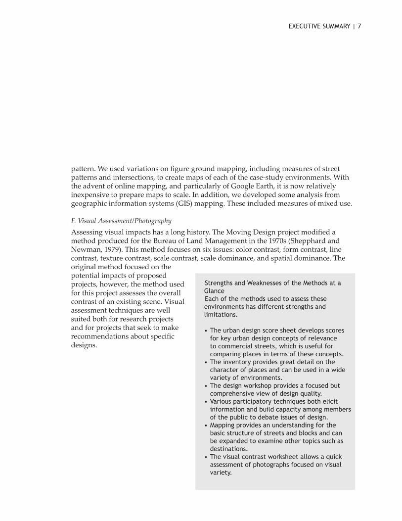
Strengths and Weaknesses of the Methods at a GlanceEach of the methods used to assess these environments has different strengths and limitations.
• The urban design score sheet develops scores for key urban design concepts of relevance to commercial streets, which is useful for comparing places in terms of these concepts.
• The inventory provides great detail on the character of places and can be used in a wide variety of environments.
• The design workshop provides a focused but comprehensive view of design quality.
• Various participatory techniques both elicit information and build capacity among members of the public to debate issues of design.
• Mapping provides an understanding for the basic structure of streets and blocks and can be expanded to examine other topics such as destinations.
• The visual contrast worksheet allows a quick assessment of photographs focused on visual variety.

8 | MOVING DESIGN
Cases The design principles and issues outlined in earlier sections are common to projects in a wide variety of situations. The project examined cases in three regions: in Washington, DC, and Northern Virginia; in the St. Louis area of Missouri and Illinois as well as Boonville in central Missouri; and in Northern California in Oakland and Davis. The goal of these case studies was to explore in more detail the uses of these methods for measuring the built environment.
Case studies were selected to demonstrate good design in a range of locations and situations.
• Several of the cases include affordable housing development near station areas, most notably Fruitvale, California and Emerson Park, Illinois.
• Others involve revitalized shopping streets o�en reached from a train station—for example at Clarendon in Virginia, Barracks Row in the District of Columbia,
Delmar Loop in St. Louis, and International Boulevard near Fruitvale in California.• Some have major office development, including Rosslyn and Ballston in Virginia
and the 12th Street area in Oakland. • A number of projects preserve historic landscapes and buildings, including
Virginia Route 50 and a park in Booneville, Missouri.• Many have mixed use areas.
Major Cases State Type Major Retail Affordable Housing
HistoricPreservation Mixed Use
12th Street/Oakland City Center CA TOD x x xBallston VA TOD x xBarracks Row DC CSS x xBoonville MO CSS x Clarendon VA TOD x xDavis CA CSS xDelmar Loop MO TOD x x xEmerson Park IL TOD x Fruitvale CA TOD x x xRosslyn VA TOD x xRoute 50 VA CSS x x
The eleven case-study sites listed below are outlined in more detail in part three of this report.

EXECUTIVE SUMMARY | 9
All cases demonstrate the capacity of well-designed transportation infrastructure to enhance a sense of place in terms of community identity, scenic quality, and cultural value.
In addition to these cases, the background report draws on research and observation by the study team and others across the globe. Illustrations come not only from North America but from Europe, Japan, and Australasia. While the United States has many examples of well-designed environments around transportation facilities, international comparisons are also valuable for demonstrating a wider range of possible design contexts and solutions.
Design ToolkitOne-size-fits-all solutions to design problems certainly do not fit all, as the tastes and needs of varied users are rarely the same, and are sometimes even in direct conflict. Instead, it is perhaps be�er to think of a good design toolkit – or a set of good, not necessarily “best” practices, each with particular effects in particular situations. Selecting from different parts of the toolkit, people responsible for the design of places can mix and match solutions to problems. Good design, then, is not as much a product but a process of assessing, selecting, and implementing of a wide number of individual design interventions.
As was explained earlier, the toolkit of design and measurement practices has four main parts: methods, processes and time, places, and facilities. Within each of these parts principles for good design are identified. These principles are drawn from the results of this study of visual issues as well as from a number of exemplary reports on urban design aspects of transportation. These design principles are summarized below.

10 | MOVING DESIGN
Boonville: The Cobblestone Street Interpretive Park opened in 2000 and demonstrates that modern transportation needs can be achieved without sacrificing local concerns for historic preservation and place promotion.
Clarendon: The first plan to specifically deal with Clarendon was released in 1984 and articulated a vision for Clarendon as an “urban village,” meaning greater development around the station while maintaining the strong sense of place.
Davis: The City of Davis, California has a well-earned reputation as America’s leader in supporting and encouraging bicycle transportation.
Delmar Loop:The MetroLink in this area preserved and extended the existing commercial activity in the area from University City across the municipal border to the station in the City of St. Louis.
Ballston:The Ballston station area includes significant office and retail areas as well as a wide variety of housing options. It is notable for the diverse mix of uses in this area.
Barracks Row:8th Street Barracks Row is one of Washington D.C.’s oldest commercial neighborhoods. The area was a winner of the Great American Main Street Award in 2005.

EXECUTIVE SUMMARY | 11
Emerson Park: In Emerson Park, transit-oriented development was brought to the area through community activism and has been used to spark redevelopment in the economically troubled City of East St. Louis.
Fruitvale: The proposal for a transit village at Fruitvale grew out of a Community Design Symposium between BART and Fruitvale community leaders in which both tried to work together to figure out a common solution to their respective problems.
Oakland City Center/12th Street: Oakland’s downtown has different parts with distinctive characters. This ongoing transformation demonstrates the challenges and benefits of implementing transit-oriented development in an already established area.
Rosslyn: The Rosslyn station is the gateway to Arlington County on the Metro, and the eastern most station in the TOD corridor.
Route 50: Set in a very scenic part of northern Virginia, just beyond the outer edges of the Washington DC metro area, Virginia Route 50 is a lovely tourist drive that demonstrates the many benefits of thoughtful design that takes citizen input into account.

12 | MOVING DESIGN
Methods 1. Use multiple assessment tools to tap multiple concepts While converging on a generally similar picture of each of the case-study areas, the different assessment techniques each provide different information about the visual environment of the place. Some techniques identify elements within the place—such as street furnishings—and others assess design quality. There is no one best method for visual assessment. A best practice is to use multiple methods of assessment.
2. Understand that different concepts are relevant to different places The various assessment tools measure a variety of urban design features from imageability, or how memorable a site is, to whether there is pedestrian lighting present. Of course, places differ and not all places stive for the same qualities. There are many definitions of good design. It is important to focus on understanding the particular character of a place in order to decide which concepts are relevant and which aspects of design should be measured.
Methods: Different places have different strengths as these images from the Great Smoky Mountains and Shibuya in Tokyo demonstrate—in this case the difference between a scenic road dominated by vegetation and a high-density active commercial area near a major train station. By using different assessment methods it is possible to capture some of this diversity.
EXECUTIVE SUMMARY | 13
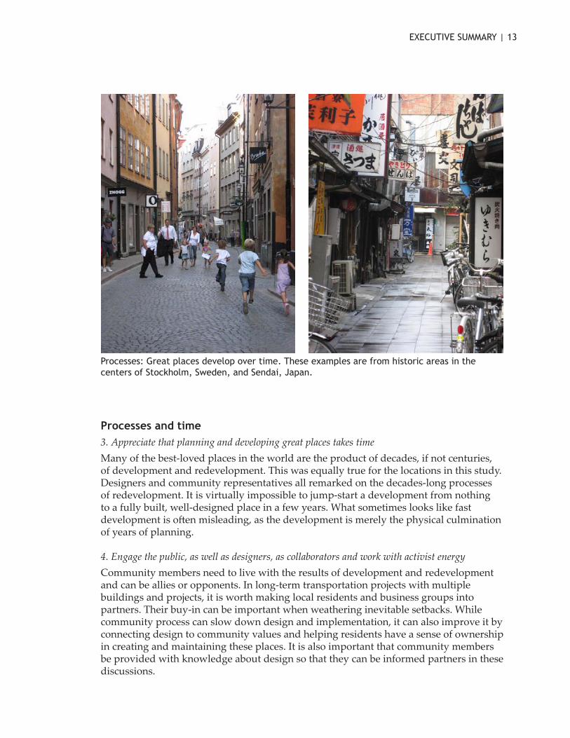
Processes and time 3. Appreciate that planning and developing great places takes time Many of the best-loved places in the world are the product of decades, if not centuries, of development and redevelopment. This was equally true for the locations in this study. Designers and community representatives all remarked on the decades-long processes of redevelopment. It is virtually impossible to jump-start a development from nothing to a fully built, well-designed place in a few years. What sometimes looks like fast development is o�en misleading, as the development is merely the physical culmination of years of planning.
4. Engage the public, as well as designers, as collaborators and work with activist energy Community members need to live with the results of development and redevelopment and can be allies or opponents. In long-term transportation projects with multiple buildings and projects, it is worth making local residents and business groups into partners. Their buy-in can be important when weathering inevitable setbacks. While community process can slow down design and implementation, it can also improve it by connecting design to community values and helping residents have a sense of ownership in creating and maintaining these places. It is also important that community members be provided with knowledge about design so that they can be informed partners in these discussions.
Processes: Great places develop over time. These examples are from historic areas in the centers of Stockholm, Sweden, and Sendai, Japan.

14 | MOVING DESIGN
5. Program spaces for use A design is a physical space. Programming is about use. Successful places have appropriate activities occurring at different times of the day, week, and year. Of course not all places need to have constant activity, but appropriate programming can increase use, safety, and sense of place.
6. Invest in maintaining spaces A number of studies have found that high levels of maintenance are appreciated by viewers and can make places more a�ractive. Too o�en paths, trails, and other pedestrian and biking facilities are installed without long-term maintenance plans. In addition, wear and tear increases as places become popular, adding to the maintenance burden.
Places 7. Design at a human scale Designing at a human scale is the foundation of creating a great place. This means design that contains elements of similar size to parts of the human body and design that is meant to be viewed by people at walking pace. Human scale is measured explicitly in the urban design score sheet, was referred to by workshop participants, and is a key component of the AIA 2005 livability principles. This does not preclude places with tall buildings and intensive development. Rather, it stresses that design of the areas that people inhabit—such as sidewalks, plazas, and transit stations—should be scaled to be usable and interesting to people moving at walking speed.
Places: Human scale and choices are features of well-designed commercial streets, as is demonstrated at Delmar Loop in Missouri.

EXECUTIVE SUMMARY | 15
8. Provide public spaces that accommodate a variety of uses and users Successful transportation environments a�ract people moving through them. Public spaces – places where people can stop, sit, and gather—are o�en ignored in transportation projects, where the emphasis is on moving people around. Good public spaces are ones where people like to stop and sit to read a newspaper, eat a lunch, or meet friends. They also provide places for people from different groups to either interact or stake out territory without overly bothering others.
9. Use design and programming strategies to increase safety Personal safety is at the base of successful public spaces and is critically important for encouraging use in transportation environments. Programming and use of spaces is vitally important. Many of the case-study areas were well used and had successful formal and informal policing of spaces. Specific design strategies can improve safety and the perception of safety and thus make the spaces more likely to be used including lighting, delineating public and private space, ensuring visibility, and limiting the potential for entrapment.
10. Allow for variety and complexity Transportation environments that have a high level of consistency, as well as those with much variety and complexity, can provide a positive sense of place. In the United States, however, regulation tends to make areas uniform and so particular a�ention is needed to promote visual variety and a diversity of uses. Strategies include allowing mixed-use strategies and providing flexible design guidelines.
11. Create connections between spaces It is important to make great transportation environments but it is also important to connect them to the broader urban fabric. All the case-study areas had well-connected street pa�erns relevant to their locations. The transit-oriented development areas in particular had similar pa�erns of streets and relatively small blocks allowing multiple options for movement. Buildings, however, did not always connect well to the outdoors and sidewalks were not always continuous for pedestrians. Cyclists had even more challenges finding comfortable paths.

16 | MOVING DESIGN
Facilities 12. Design sidewalks and crosswalks, for appropriate pedestrian use Creating spaces that encourage walking depends partially on proper design of spaces reserved for pedestrians, and partially on places where pedestrians intersect with other users, especially motorists. From sidewalks to crosswalks, successful places have appropriate facilities.
13. Create spaces for bicycles and bike parking Bicyclists are another type of transportation user whose presence and needs should be accounted for in the design process. Designing for bicyclists can be difficult, because in some ways their needs are similar to those of pedestrians, in other ways to drivers, but in still other ways, their needs are unique. Overall, bicycle infrastructure is part of a system that includes paths and parking.
14. Integrate transit and transit facilities into the urban pa�ern The design of bus and rail facilities is complicated, as various needs and constraints must be properly balanced. A transit facility is a transition point between various modes, as people park cars and bikes and walk before heading on to mass transit. People also
Facilities: Facilities for pedestrians, motorists, cyclists, and transit can all exhibit good design. This pedestrian bridge over a roadway at Millennium Park in Chicago reflects the avant garde architecture of the park.

EXECUTIVE SUMMARY | 17
transfer between routes or types of transit. Modern transit facilities, especially in the case of transit-oriented development add shoppers, workers, and residents to this mix creating an even more diverse set of demands and expectations on transit facilities. These challenges also bring opportunities. Transit naturally brings people together, a key goal of urban designers seeking to promote vibrant street life. Transit can also serve as the impetus for economic or community development in a place, as investments in transit offer a chance to pursue other, complementary goals.
15. Do not forget, but do not overemphasize, car movement and parking A number of design elements for streets can be used to create more walkable places, while simultaneously making the urban or suburban environment safe for drivers, as well. Many of these entail slowing down or restricting traffic to a more suitable level for the areas through which they pass. Reduced levels of service should be compensated for in other ways, however, such as by enhancing traffic capacity on parallel or nearby streets.
ConclusionGood design and planning—both process and product—involves using this toolkit in a way that is responsive to context and can be appreciated by different publics. Over time design can be a catalyst for other benefits.
Facilities: A street median at the planned community of Civano in Arizona uses local plants to reinforce a sense of place and to integrate the roadway with the overall design concept of this new neighborhood.

REFERENCES | 18
ReferencesAdams, A. 1994. St. Louis Metrolink: Changing the rules of transit design. Places 9, 2:
88-90.Alexander, C., S. Ishakawa and M. Silversteen. 1977. A pa�ern language. New York:
Oxford University Press.Alfonzo, M., K. Day and M. Boarnet. 2005. Irvine Minnesota Inventory for
observation of physical environment features linked to physical activity. Training protocol. h�ps://webfiles.uci.edu/kday/public/index.html.
Alschuler, K. B., and S. B. Smith. 1997. Transit and development: St. Louis Metrolink. Urban Land 56, 4: 38-41.
American Association of State Highway and Transportation Officials (AASHTO). 1991. Guide for the development of bicycle facilities. Task Force on Geometric Design, Washington, DC.
American Institute of Architects (AIA). 2005. Livability 101. Washington, DC: AIA._____. 2002. Arlington County, Va., for smart growth in the Rosslyn-Ballston metro
corridor. AIArchitect, Nov. 2005. h�p://www.aia.org/aiarchitect/thisweek02/tw1122/1122tw2smartgrowth_oe.htm.
Appleyard, D., K. Lynch and J. Myer. 1964. The view from the road. Cambridge, MA: MIT Press.
Arlington Arts. 2007. Art market at Ballston. Arlington Arts [online database], Arlington, VA. h�p://www.arlingtonarts.org/arts_comm/artmarket.htm.
Arts in Transit. 2006. Metro arts in transit: Mission. Arts in Transit [online database], St. Louis, MO. h�p://www.artsintransit.org/pages/mission.html.
Balling, J. D., and J. H. Falk. 1982. Development of visual preference for natural environments. Environment and Behavior 14, 1: 5-28.
Barnet, J. 2004. What a height limit does for a city [Washington, D.C.]. Planning 70, 2: 14-15.
_____. 2002. Turning edge cities into real cities. Planning 68, 11: 10-13. Barracks Row Main Street. 2007. Barracks Row main street: Capitol Hill. Barracks
Row Main Street [online database], Washington, DC. h�p://www.barracksrow.org/. Bates, T. 1994. Transit Village Development Planning Act of 1994 (AB 3152).
Sacramento: California Assembly. Bay Area Rapid Transit District (BART). 2007. BART system map. Oakland, CA:
BART [online database]. h�p://www.bart.gov/stations/map/systemMap.asp.

19 | MOVING DESIGN
_____. 2006a. History of BART. BART [online database], Oakland, CA. h�p://www.bart.gov/about/history/history_1.asp.
_____. 2006b. BART customer data: Ridership statistics, fiscal year average weekday exits by station. Oakland, CA: BART.
_____. 2005. Fiscal year 2005 annual report. Oakland, CA: BART.Beatley, T. 2000. Green urbanism: Learning from European cities. Washington, DC: Island
Press.Bernick, M. 1996. Transit villages: Tools for revitalizing the inner city. Access: Research
at the University of California Transportation Center 9:13-17.Bijoux, D., and J. Myers. 2006. Interviews, solicited diaries, and photography: ‘New’
ways of accessing everyday experiences of place. Graduate Journal of Asia-Pacific Studies 4: 21.
Bishop, I. D. 2002. Determination of thresholds of visual impact: The case of wind turbines. Environment and Planning B: Planning and Design 29: 707-18.
Bishop, I. D., J. R. Wherret and D. R. Miller. 2000. Using image depth variables as predictors of visual quality. Environment and Planning B: Planning and Design 27: 865-75.
Bi-state Development Agency of the Missouri-Illinois Metropolitan District (Metro). 2006a. Inside MetroLink. Bi-State Development Agency of the Missouri-Illinois Metropolitan District [online database], St. Louis, MO. h�p://www.metrostlouis.org/InsideMetro/QuickFacts/metrolink.asp.
_____. 2006b. Emerson Park Security and Commercial Building. Bi-state Development Agency of the Missouri-Illinois Metropolitan District [online database], St. Louis, MO. h�p://www.metrostlouis.org/InsideMetro/CapitalProjects/buscenters/emersonpark.asp.
_____. 2005. Fiscal year 2005 annual report. St. Louis: Bi-state Development Agency of the Missouri-Illinois Metropolitan District.
Boarnet, M., K. Day, M. Alfonzo, A. Forsyth, and M. Oakes. 2006. The Irvine Minnesota Inventory to measure built environments: Reliability tests. American Journal of Preventative Medicine 30, 2: 153-59.
Boje, A. 1971. Open plan offices. London: Business Books.Burden, D. 1999. Street design guidelines for healthy neighborhoods, vol. TRB
circular E-C019. Sacramento: Local Government Commission’s Center for Livable Communities.
Calthorpe, P. 1993. The next American metropolis: Ecology, community and the American dream. New York: Princeton Architectural Press.

REFERENCES | 20
Carmona, M., T. Heath, T. Oc, and S. Tiesdell. 2003. Public places: Urban spaces. Oxford: Architectural Press.
Cervero, R. 1998a. The transit metropolis: A global inquiry. Washington, DC: Island Press.
_____. 1998b. Transit villages in California: Progress, prospects, and policy reforms. Working Paper 98-08. Berkeley: Institute of Urban and Regional Development, University of California at Berkeley.
_____. 1994. Rail transit and joint development: Land market impacts in Washington, DC, and Atlanta. Journal of the American Planning Association 60, 1: 83-94.
Citizens for Modern Transit. 2006a. TOD in St. Louis. Citizens for Modern Transit [online database], St. Louis, MO. h�p://www.cmt-stl.org/metrolink/tod.html.
_____. 2006b. TOD in St. Clair County. Citizens for ModernTransit [online database], St. Louis, MO. h�p://www.cmt-stl.org/metrolink/tod3.html.
_____. 2006c. Tracking development near Illinois MetroLink stations. Citizens for Modern Transit [online database], St. Louis, MO. h�p://www.cmt-stl.org/metrolink/tod8.html.
City of Davis, California. 2006. City of Davis comprehensive bicycle plan. Public Works Department and Bicycle Advisory Commission.
City of Oakland, California. 2006. 10k housing initiative. Community and Economic Development Agency (CEDA) [online database], Oakland, CA. h�p://www.business2oakland.com/main/10kdowntownhousinginitiative.htm.
_____. 2003. Oakland leads nation in transit-oriented development. Oakland, CA: CEDA.
City of Toronto, Ontario [Canada] and G. R. Werkerle. 1992. A working guide for planning and designing safer urban environments. Toronto: City of Toronto, Planning and Development Department, Safe City Commi�ee.
Clemente, O., R. Ewing, S. Handy, and R. Brownson. 2005. Measuring urban design qualities: An illustrated field manual. Prepared for the Active Living Research, Robert Wood Johnson Foundation.
Collins, R. 1980. Rosslyn: The problem of the high rise and the nation’s capital. Modulus 78-83.
Congress for the New Urbanism. 1996. Charter of the new urbanism. h�p://www.cnu.org/charter.
Context Sensitive Solutions. 2005a. Barracks Row. Context Sensitive Solutions [online database], Washington, DC. h�p://www.contextsensitivesolutions.org/content/case_studies/DC_Barracks/.

21 | MOVING DESIGN
_____. 2005b. Cobblestone Street interpretive park. Context Sensitive Solutions [online database], Washington, DC. h�p://www.contextsensitivesolutions.org/content/case_studies/480_cobble/.
Cooper Marcus, C., and C. Francis. 1998. People places: Design guidelines for urban open space. New York: Van Nostrand Reinhold.
Cooper Marcus, C., and W. Sarkissian. 1986. Housing as if people ma�ered. Berkeley: University of California Press.
County of Arlington, Virginia. 2006. Creative affordable housing development tools. 2006. Arlington, VA: Dept. of Community Planning, Housing and Development (CPHD). h�p://www.arlingtonva.us/Departments/CPHD/Documents/8586Creative%20Housing%20Tools.pdf.
_____. 2005. Development in the Metro corridors (1960-2005): Development summary for the Rosslyn Metro station area. Arlington, VA: CPHD.
_____. 2004. R-B corridor streetscape: Streetscape standards for the Rosslyn-Ballston Metro corridor. Updated ed. Arlington, VA: CPHD, Planning Div.
_____. 1972. R-B ‘72 Rosslyn-Ballston corridor alternative land use pa�erns. Arlington, VA: Dept. of Community Affairs, Planning Div.
_____. 1967. Rosslyn, Arlington County, Virginia. Arlington, VA: Office of Planning.Crewe, K. and A. Forsyth. 2003. LandSCAPES: A typology of approaches to
landscape architecture. Landscape Journal 22, 1: 37-53.Davis, A. M. 2003. Next-door neighbors: Commercial and residential properties
redefine their relationship in the mid-Atlantic states. Urban Land 62, 4: 52-7.Day, K., M. Boarnet and M. Alfonzo. 2005a. Irvine Minnesota Inventory for
observation of physical environment features linked to physical activity. Codebook. h�ps://webfiles.uci.edu/kday/public/index.html.
Day, K., M. Boarnet, M. Alfonzo, and A. Forsyth. 2006. The Irvine Minnesota Inventory to measure built environments: Development. American Journal of Preventive Medicine 30, 2: 144-52.
_____. 2005b. Irvine Minnesota Inventory. Print version. h�ps://webfiles.uci.edu/kday/public/index.html.
_____. 2005c. Irvine Minnesota Inventory. Microso� Access version. h�ps://webfiles.uci.edu/kday/public/index.html.
_____. 2005d. Irvine Minnesota Inventory. Training protocol. h�ps://webfiles.uci.edu/kday/public/index.html.
Design for Health. 2007. Rapid health impact assessment toolkit. Version 1.1. h�p://www.designforhealth.net.

REFERENCES | 22
Devlin, K. 1990. An examination of architectural interpretation: Architects versus non-architects. Journal of Architectural and Planning Research 7, 3: 235-244.
Di�mar, H., and G. Ohland, eds. 2004. The new transit town. Washington, DC: Island Press.
Dodman, D. R. 2003. Shooting in the city: An autophotographic exploration of the urban environment in Kingston, Jamaica. Area 35: 293-304.
Dorn, P. 2001. Cycling in bike-friendly Davis. h�p://runmuki.com/paul/writing/davis.html.
Duany, A., E. Plater-Zyberk and J. Speck. 2000. Suburban nation. New York: North Point Press.
East Lake Management and Development Corporation. h�p://www.eastlakemgmt.com/.
East Saint Louis Action Research Project (ESLARP). 2007. East Saint Louis Action Research Project. College of Fine and Applied Arts, University of Illinois at Urbana-Champaign [online database], Urbana-Champaign, IL. h�p://www.eslarp.uiuc.edu/.
Emerson Park Development Corporation (EPDC). 2007. Emerson Park Development Corporation. EPDC [online database], East St. Louis, IL. h�p://www.meptv.com/epdctest/contact.htm.
Evans, G., C. Smith and J. Rezdah. 1982. Cognitive maps and urban form. Journal of the American Planning Association Spring: 232-44.
Ewing, R. 2000. Asking transit users about transit-oriented design. Paper presented at79th Annual Transportation Research Board Meeting, Washington DC, January.
h�p://www.trbpi.com/publications/00059.pdf.Ewing, R., O. Clemente, S. Handy, R. Brownson, and E. Winston. 2005 [Is this a or b;
see Ewing et al. below?]. Measuring urban design qualities related to walkability. Final report prepared for Active Living Research, Robert Wood Johnson Foundation. h�p://www.activelivingresearch.org/index.php/Urban_Design_Quantities_Related_to_Walkability/357.
Ewing, R., S. Handy, R. C. Brownson, O. Clemente, and E. Winston. 2006. Identifying and measuring urban design qualities related to walkability. Journal of Physical Activity and Health 3 (Suppl 1), S223-40.
Ewing, R., M. King, S. Raudenbush, and O. J. Clemente. 2005 [Is this a or b; see Ewing et al. above?]. Turning highways into main streets: Two innovations in planning methodology. Journal of the American Planning Association 71, 3: 269-81.

23 | MOVING DESIGN
Forsyth, A., ed. 2005a. Environment and physical activity: GIS protocols. Minneapolis: University of Minnesota Design Center.
Forsyth, A. 2005b. Reforming suburbia: The planned communities of Irvine, Columbia, and the Woodlands. Berkeley: University of California Press.
_____. 2002. Who built Irvine? Private planning and the federal government. Urban Studies 39, 13: 2507-30.
Forsyth, A., and K. Crewe. 2006. Research in environmental design: Definitions and limits. Journal of Architectural and Planning Research 23, 2: 160-75.
Forsyth, A., and L. Musacchio. 2005. Designing small parks: A manual for addressing social and ecological concerns. New York: Wiley.
Forsyth, A., J. M. Oakes, K. H. Schmitz, and M. Hearst. 2007 Does residential density increase walking and other physical activity? Urban Studies 44, 4: 679-97.
Forsyth, A., and W. Sarkissian. 1994. Housing for older Australians: Site planning basics. Australian Planner (Journal of the Royal Australian Planning Institute) 33, 3: 177-83.
Gaillard, L. 2005. Context sensitive design case study no. 7: Route 50 - Loudon-Fauquier counties, Virginia. Context Sensitive Solutions [online database]. h�p://www.contextsensitivesolutions.org/content/case_studies/kentucky_50/.
Gelfand, Mark. 1975. A nation of cities: The federal government and urban America, 1933-1965. New York: Oxford University Press.
Gifford, R., D. W. Hine, W. Muller-Clemm, and K.T. Shaw. 2002. Why architects and laypersons judge buildings differently: Cognitive properties and physical bases. Journal of Architectural and Planning Research 19, 2: 131-48.
Girling, C., and K. Helphand. 1994. Yard, street, park: The design of suburban open space. New York: Wiley.
Gobster, P. H. 1994. The urban savanna: Reuniting ecological preference and function. Restoration and Management Notes 12, 1: 64-71.
Gobster, P. H., and R. Chenoweth. 1989. The dimensions of aesthetic preference: A quantitative analysis. Journal of Environmental Management 29: 47-72.
Grady, S., and G. LeRoy. 2006. Making the connection: Transit-oriented development and jobs. Washington, DC: Good Jobs First.
Green, R. 2000a. Notions of town character. Australian Planner 37, 2: 76-86._____. 2000b. Scenic and town character assessment. Australian Planner 37, 1: 28-34.Greenberg, E. 2004. Regulations shape reality: Zoning for transit-oriented
development. The new transit town: Best practices in transit-oriented development. Hank Ditmar and Gloria Ohland, eds. Washington, DC: Island Press.

REFERENCES | 24
Hanyu, K., J. Nasar and A. E. Stamps III. 2005. Using pre-construction validation to regulate urban skylines. Journal of the American Planning Association 71: 73-92.
Hayward, S. C., and S. S. Franklin. 1974. Perceived openness-enclosure of architectural space. Environment and Behavior 6: 37-52.
Henry, K. 2006a. Clarendon Metro station area: Development in the Metro corridors 1960-2005. Arlington County Department of Community Planning, Housing and Development [online database], Arlington, VA. h�p://www.co.arlington.va.us/Departments/CPHD/planning/data_maps/metro/clarendon/#intro.
_____. 2006b. Rosslyn Metro station area: Development in the Metro corridors 1960-2005. Arlington County Department of Community Planning, Housing and Development [online database], Arlington, VA. h�p://www.co.arlington.va.us/Departments/CPHD/planning/data_maps/metro/rosslyn#intro.
_____. 2006c. Ballston Metro station area: Development in the Metro corridors 1960-2005. Arlington County Department of Community Planning, Housing and Development [online database], Arlington, VA. h�p://www.co.arlington.va.us/Departments/CPHD/planning/data_maps/metro/ballston/#top
Howard, E. 1985. Garden cities of to-morrow. Rev. edition. Eastbourne, East Sussex, UK: A�ic Books.+
Howland, L., and R. T. Dunphy. 1996. Transit sparks redevelopment in St. Louis and Chicago. Urban Land 55, 7:43-6.
Hubbard, P.J. 1997. Diverging a�itudes of planners and the public: an examination of architectural interpretation Journal of Architectural and Planning Research 14, 4: 317-328.
Im, S. 1984. Visual preferences in enclosed urban spaces: An exploration of a scientific approach to environmental design. Environment and Behavior 16 (2): 235-62.
Institute of Transportation Engineers. 2006. Context sensitive solutions in designing major urban thoroughfares for walkable communities. Washington, DC: Institute of Transportation Engineers.
Ison, E. 2002. Rapid appraisal tool for health impact assessment: A task-based approach. 11th ed. Oxford: Institute of Health Sciences.
Jacobs, A. 1993. Great streets. Cambridge, MA: MIT Press.Jacobs, A., and D. Appleyard. 1987. Toward an urban design manifesto. Journal of the
American Planning Association 53: 112-20.Jacobs, J. 1961. The death and life of great American cities. New York: Random House.

25 | MOVING DESIGN
Johnakin, S. G. 1991. Declarations for interconnected mixed-use projects. Urban Land 50, 11: 16-21.
Kaplan, R., and S. Kaplan. 1989. The experience of nature: A psychological perspective. Cambridge: Cambridge University Press.
Kaplan, R., S. Kaplan and R. Ryan. 1998. With people in mind: Design and management of everyday nature. Washington, DC: Island Press.
Kozol, Jonathan. 1992. Savage inequalities: Children in America’s schools. New York: HarperPerennial.
Krieger, A. 2006. Where and how does urban design happen? Harvard Design Magazine 24: 64-71.
Lang, J. 2005. Urban design: A typology of procedures and products. Oxford: Architectural Press.
Latham, A. 2003. Research, performance, and doing human geography: Some reflections on the diary-photograph, diary-interview method. Environment and Planning A 35: 1993-2017.
Lawson, B. 2006. How designers think: The design process demystified. Oxford: Architectural Press.
Lazzara, J., and L. Arrigoni. 2004. Context sensitive solutions: A collaborative process for planning, design and construction. Transport Line 14, 1.
League of American Bicyclists. 2005. First platinum-level bicycle friendly community recognized. League of American Bicyclists [online database], Washington, DC. h�p://www.bicyclefriendlycommunity.org/October2005awards.htm.
Loop Special Business District, The. 2006a. University City, St. Louis: The Delmar Loop. The Loop Special Business District [online database], St. Louis, MO. h�p://www.ucityloop.com.
_____. 2006b. The Loop in Motion Festival. The Loop Special Business District [online database], St. Louis, MO. h�p://www.ucityloop.com/loopinmotion/index.html.
Lo�, D. 2003. How our bike lanes were born. Davis Enterprise August. Lynch, K. 1981. Good city form. Cambridge, MA: MIT Press._____. 1960. The image of the city. Cambridge, MA: MIT Press.Malvin, J. 2005. UC Davis, city growth policies in opposition. The California Aggie
September 29.Marcuse, P. 1997. The enclave, the citadel, and the ghe�o: What has changed in the
post-Fordist US city. Urban Affairs Review 33, 2: 228-64.Marshall, A. 2004. Love (and hate) that Metro [Washington, DC]. Planning 70, 2: 18-
23.

REFERENCES | 26
McCormack Baron 2006. Parsons Place fact sheet. h�p://www.mccormackbaron.com/HTML/ParsonsPhaseI_Opening.pdf
_____. 2004. Parsons Place phase 2. h�p: //www.mccormackbaron.com/HTML/ParsonsPhaseII_Closing.pdf.
McHarg, I. 1969. Design with nature. Garden City, NY: Doubleday/Natural History Press.
McNeal, A. R., R. P. Dogge� and R. T. Dunphy. 1999. Metro makes its mark. Urban Land 58, 9: 78-81.
Menegaki, M. E., and D. C. Kaliampakos. 2006. Landscape analysis as a tool for surface mining design. Environment and Planning B 33, 185-96.
Meth, P. 2003. Entries and omissions: Using solicited diaries in geographical research. Area 35: 195-205.
Miller, L. S. 1996. MetroLink: The spirit of St. Louis. Railway Age 197, 3: 64-8.Miller, M. R. 1993. Joint development at Ballston Metro Center [Arlington, VA].
Urban Land 52, 6: 22-4.Moler, S. 2002. A hallmark of context-sensitive design. Public Roads 65, 6: 6-13.Moudon, A. V. 1992. A Catholic approach to organizing what urban designers should
know. Journal of Planning Literature 6, 4: 331-49.Moudon, A. V., and C. Lee. 2003. Walking and bicycling: An evaluation of
environmental audit instruments. American Journal of Health Promotion 18 (1): 21-37.Nasar, J. 1998. The evaluative image of the city. Thousand Oaks, CA: Sage.Nasar, J. L. & Kang, J. 1989. A post-jury evaluation: The Ohio State University design
competition for a center for the visual arts. Environment and Behavior, 21: 464-484. Nassauer, J. I., and D. Larson. 2004. Aesthetic initiative measurement system: A
means to achieve context-sensitive design. Transportation Research Record 1980: 88-96.
National Cooperative Highway Research Program (NCHRP). 2002. A Guide to Best Practices for Achieving Context Sensitive Solutions. Washington, DC; Transportation Research Board.
National Trust for Historic Preservation. 2005. Barracks Row, DC, receives Great American Main Street Award. National Trust Main Street Center, Washington, DC. h�p://awards.mainstreet.org/MediaLibrary/2005_GAMSA_Release_BarracksRow.pdf.
Neuman, T. R., M. Schwartz, L. Clark, and J. Bednar. 2002. A guide to best practices for achieving context sensitive solutions. Washington, DC: Transportation Research Board.

27 | MOVING DESIGN
Nick Wates Associates. No date. Community planning handbook: Methods. h�p://www.communityplanning.net/methods/methods.htm.
Nivola, P. 1999. Laws of the landscape: How policies shape cities in Europe and America. Washington, DC: Brookings Institution Press.
Ohland, G., and Great American Station Foundation. 2001. Transit-oriented development in four cities. h�p://community-wealth.com/_pdfs/articles-publications/tod/paper-ohland.pdf.
Old Oakland Historic District. 2006. Old Oakland Historic District: History. Old Oakland Historic District Business Association [online database], Oakland, CA. h�p://oldoakland.org/oo/index.cfm.
Oldham, S., and J. Vaughan. 2004. U.S. Route 50: Loudon-Fauquier counties, Virginia. Context-sensitive design around the country: Some examples. Washington, DC: Transportation Research Board.
Olson, L. No date. Fruitvale BART community redevelopment project. Washington, DC: Mobility Partners.
Ortbals, A. 2004. East St. Louis’ Emerson Park neighborhood lands second housing development. Illinois Business Journal 4, 4. h�p://www.ibjonline.com/east_stlouis_emerson_park.html.
Owen, W. 1959. Cities in the motor age. New York: Viking Press.Parker, T., and G. B. Arrington. 2002. Statewide transit-oriented development study:
Factors for success in California. Executive summary. Sacramento: California Department of Transportation.
Parker, T., and D. Mayer. 2007. California transit-oriented development (TOD) searchable database. Sacramento: California Department of Transportation [online database]. h�p://transitorienteddevelopment.dot.ca.gov/miscellaneous/NewHome.jsp.
Parris, M. 1989. The Rosslyn-Ballston corridor: Early visions. Arlington, VA: Arlington County Department of Community Planning, Housing and Development.
Raffe�o, J. 1993. Perceptions of ecological restorations in urban parks policy recommendations and directions: A Lincoln Park case study. Managing urban and high-use recreation se�ings. P. Gobster, ed. St. Paul, MN: US Department of Agriculture, North Central Forest Experiment Station.
Rahman, O. M. A. 1992. Visual quality and response assessment: An experimental technique. Environment and Planning B: Planning and Design 19: 689-708.

REFERENCES | 28
Rapoport, A., and R. Hawkes. 1970. The perception of urban diversity. Journal of the American Institute of Planners 36, 106-11.
Rapoport, A., and R. E. Kantor. 1967. Diversity and ambiguity in environmental design. Journal of the American Institute of Planners 33, 210-22.
Reardon, K. M. 2003. Riding the rails. Montclair, NJ: National Housing Institute.Rouse, J. 1966. In hearings before subcommi�ee number 5, of the Commi�ee on the
Judiciary, House of Representatives, Eighty-ninth Congress, on miscellaneous proposals regarding the civil rights of persons within the jurisdiction of the United States. Washington, DC: US Government Printing Office.
Route 50 Corridor Coalition. 2007. Route 50 corridor coalition. Route 50 Corridor Coalition [online database], Middleburg, VA. h�p://www.route50.org/index.html.
St. Louis Front Page. 2001. Parsons Place in Emerson Park. Construction News, July 5.Salay, E. 2004. Barracks Row. Context Sensitive Solutions [online database],
Washington, DC. h�p://www.contextsensitivesolutions.org/content/case_studies/DC_Barracks/.
Sandweiss, E. 2001. St. Louis: The evolution of an American urban landscape. Philadelphia: Temple University Press.
Sanoff, H. 2000. Community participation methods in design and planning. New York: Wiley.
Sarkissian, W., A. Cook and K. Walsh. 2003. Community participation in practice: A practical guide. Murdoch, Australia: Institute for Sustainability and Technology Policy, Murdoch University.
Schauman, S. 1988a. Scenic value of countryside landscapes to local residents: A Whatcom County, Washington case study. Landscape Journal 7: 40-6.
_____. 1988b. Countryside scenic assessment. Tools and an application. Landscape and Urban Planning 15: 227-39.
Schauman, S., and M. Pfender. 1982. An assessment procedure for countryside landscapes. Sea�le: University of Washington, Dept. of Landscape Architecture.
Schroeder, H. W. 1989. Environment, behavior and design research on urban forests. Advances in Environment, Behavior and Design, vol. 2. E. H. Zube and G. T. Moore, eds. New York: Plenum.
_____. 1982. Preferred features of urban parks and forests. Journal of Arboriculture 8, 12: 317-22.
Sco�-Samuel, A., M. Birley and K. Ardern. 2001. The Merseyside guidelines for health impact assessment. 2nd ed. Liverpool: International Health Impact Assessment Consortium.

29 | MOVING DESIGN
Sheppard, S., and S. Newman. 1979. Prototype visual impact assessment manual. Produced for Bureau of Land Management. Syracuse, NY: College of Environmental Science and Forestry.
Siegman, P. 2003. Is it really TOD? Planning May: 17.Simmons, D. A. 1994. Urban children’s preferences for nature: Lessons for
environmental education. Children’s Environments 11, 3: 194-203.Sims, B., and S. Khan. 1977. Visual exposure, form uniqueness, social and functional
significance: Toward a predictive model of image formation. Man-Environment Systems 7, 6: 321-31.
Snyder, J., ed. 1984a. Architectural research. New York: Van Nostrand Reinhold._____. 1984b. Introduction to architectural research. Architectural Research, James
Snyder, ed. New York: Van Nostrand Reinhold.Sommer, R. 1997. Further cross-national studies of tree form preference. Ecological
Psychology 9, 2: 153-60.Southworth, M. 2003. Measuring the liveable city. Built Environment 29, 4: 343-54. Southworth, M., and B. Parthasarathy. 1997. The suburban public realm II. Journal of
Urban Design 2, 1: 9-34.Stamps III, A. E. 2003. Permeability and environmental enclosure. Perceptual and
Motor Skills 96, 3:1305-10._____. 2002. Environmental enclosure in urban se�ings. Environment and Behavior 34,
6: 781-94._____. 1999a. Demographic effects in environmental aesthetics: A meta-analysis.
Journal of Planning Literature 14, 2: 155-75._____. 1999b. Sex, complexity, and preferences for residential façades. Perceptual and
Motor Skills 88: 1301-12.Stamps III, A. E., J. L. Nasar and K. Hanyu. 2005. Using pre-construction validation
to regulate urban skylines. Journal of the American Planning Association 71: 73-91.Stamps III, A. E., and S. Smith. 2005. Enclosure and safety in urbanscapes.
Environment and Behavior 37, 1: 102-35._____. 2001. Evaluating enclosure in urban sites. Landscape and Urban Planning 57, 1:
25-42.State of California. 1993. Bikeway planning and design. Sacramento: California
Department of Transportation.State of Maryland. 1998. Thinking beyond the pavement: A national workshop on
integrating highway development with communities and the environment while

REFERENCES | 30
maintaining safety and performance. Conference summary. Baltimore: Maryland Department of Transportation, State Highway Administration (MDSHA).
State of Virginia. 2006. Metrorail is coming to the Dulles corridor. Richmond: Virginia Department of Rail and Public Transportation (Virginia DRPT).
State of Washington and Energy Outreach Center. 1995. Redevelopment for livable communities. Produced by Washington State Energy Office (WSEO), Department of Transportation (WSDOT) and Department of Ecology, together with the Energy Outreach Center. Olympia, WA: WSDOT Commute Trip Reduction Office (formerly at WSEO).
Sternberg, E. 2000. An integrative theory of urban design. Journal of the American Planning Association 66, 3: 265-78.
Stewart, N. H. 1980. Rosslyn: A monumental intrusion? Environmental Comment 4-7.Strickland, E. 2006. Ghost town: What if they built the future and no one came? East
Bay Express January 4.Swope, C. 2005. Rethinking the urban speedway. Governing 19, 1: 26-34.Takemoto-Weerts, D. 1998. Evolution of a Cyclist-Friendly Community: The Davis
Model. Presented at Pro Bike/Pro Walk, Santa Barbara, C.A.. Available online at: h�p://www.taps.ucdavis.edu/bicycle/davis/community.html.
Talbot, J. F., and R. Kaplan. 1993. Preferences for nearby natural se�ings: Ethnic and age variations. Managing urban and high-use recreation se�ings. P. Gobster, ed. St. Paul, MN: US Department of Agriculture, North Central Forest Experiment Station.
_____. 1984. Needs and fears: The response to trees and nature in the inner city. Journal of Arboriculture 10, 8: 222-28.
Templin, N. 1998. Developments: Learning from another town’s mistakes. Wall Street Journal August 5: 1.
Transit Cooperative Research Program (TCRP). 1997. The role of transit in creating livable metropolitan communities, vol. TCRP report 22. Washington, DC: National Academy Press.
Tumlin, J., and A. Millard-Ball. 2003. How to make transit-oriented development work. Planning May 14-19
Ulrich, R. S. 1986. Human responses to vegetation and landscapes. Landscape and Urban Planning 13: 29-44.
US Environmental Protection Agency (US EPA). 2006. National award for smart growth achievement 2002 winners - Arlington County, Virginia. US EPA [online

31 | MOVING DESIGN
database], Washington, DC. h�p://www.epa.gov/dced/arlington.htm.US Federal Highway Administration (US FHWA). 2006. What is CSS? US FHWA
[online database], Washington, DC. h�p://www.?wa.dot.gov/csd/what.cfm._____. 1998. Flexibility in highway design. Washington, DC: US FHWA. _____. 1988. Visual impact assessment for highway projects. Office of Environmental
Policy. FHWA-HI-88-054. Washington, DC: US FHWA._____. No date. Partnerships, enhancements, and public involvement: Fruitvale
Transit Village project. Washington, DC: US FHWA.Unity Council. No date. Fruitvale Village project overview. Oakland, CA: Unity
Council.Urban Places Project. 2000. The YouthPower guide: How to make your community
be�er. Manual based on work of YouthPower Project of El Arco Iris Youth and Community Arts Center, Holyoke, MA. Amherst: University of Massachuse�s Extension.
Uzell, D., and E. Jones. 2000. The development of a process-based methodology for assessing the visual impact of buildings. Journal of Architectural and Planning Research 17, 4: 330-434.
Walker, R. A. 1997. Oakland: Dark star in an expanding universe. Unpublished paper. Berkeley, CA. h�p://geography.berkeley.edu/PeopleHistory/faculty/R_Walker/OaklandDarkStar.pdf.
Ward, R. 1991. Planning for growth in Arlington County, Virginia. Urban Land 50, 1: 2-6.
Ward, S. V. 2002. Planning the twentieth century city. Chichester, UK: Wiley.Warner, S. B. 1962. Streetcar suburbs: The process of growth in Boston, 1870-1900.
Cambridge, MA: Harvard University Press. Washington Metropolitan Area Transit Authority (WMATA). 2006. WMATA facts.Washington, DC: WMATA.Werlerle, G. R., and C. Whitzman. 1995. Safe cities: Guidelines for planning, design, and
management. New York: Van Nostrand.Whyte, W. 1980. The social life of small urban spaces. Washington, DC: Conservation
Foundation.Willis, S. 1997. Metrolink: Sustaining success. New Electric Railway Journal 9, 4: 11-13.Wolf, K. 2004. Trees and business district preferences: A case study of Athens,
Georgia. US Journal of Arboriculture 30: 336-46.Wong, K., and M. Domroes. 2005. The visual quality of urban park scenes of

REFERENCES | 32
Kowloon Park, Hong Kong: Likeability, affective appraisal, and cross cultural perspectives. Environment and Planning B: Planning and Design 32: 617-32.
Zeisel, J. 2006. Inquiry by design. New York: W. W. Norton.Zucker, C. 2003. TOD is working in suburban DC. Planning May: 18.