monitoring weather and climate from space · 23 eumetsat presentation for the noaa satellite...
TRANSCRIPT

EUMETSAT Information Day, Tirana, Albania, 18-19 March 2015
MONITORING WEATHER AND CLIMATE FROM SPACE
EUMETSAT Presentation NOAA Satellite Conference 27 April – 1 May 2015
2 EUMETSAT presentation for the NOAA Satellite Conference 27 April – 1 May 2015
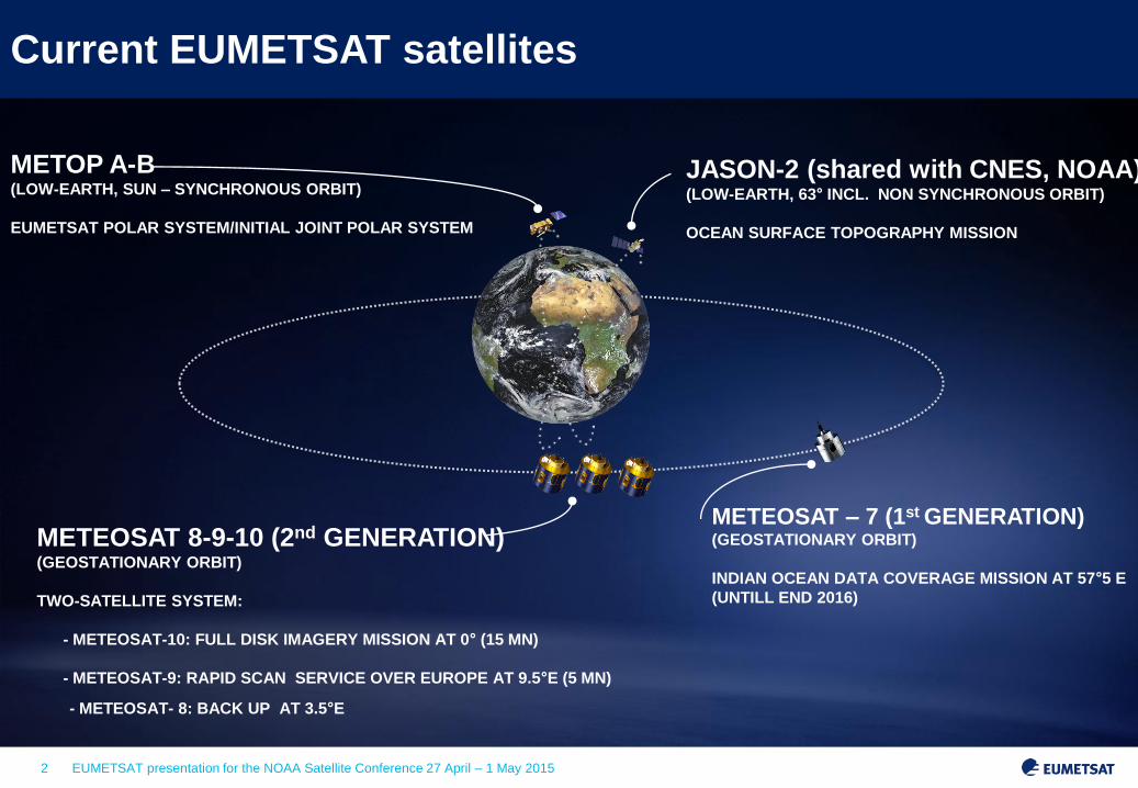
METOP A-B (LOW-EARTH, SUN – SYNCHRONOUS ORBIT)
EUMETSAT POLAR SYSTEM/INITIAL JOINT POLAR SYSTEM
JASON-2 (shared with CNES, NOAA) (LOW-EARTH, 63° INCL. NON SYNCHRONOUS ORBIT)
OCEAN SURFACE TOPOGRAPHY MISSION
METEOSAT 8-9-10 (2nd GENERATION) (GEOSTATIONARY ORBIT)
TWO-SATELLITE SYSTEM:
- METEOSAT-10: FULL DISK IMAGERY MISSION AT 0° (15 MN)
- METEOSAT-9: RAPID SCAN SERVICE OVER EUROPE AT 9.5°E (5 MN)
METEOSAT – 7 (1st GENERATION) (GEOSTATIONARY ORBIT)
INDIAN OCEAN DATA COVERAGE MISSION AT 57°5 E
(UNTILL END 2016)
Current EUMETSAT satellites
- METEOSAT- 8: BACK UP AT 3.5°E
3 EUMETSAT presentation for the NOAA Satellite Conference 27 April – 1 May 2015
03 04 05 06 07 08 09 10 11 12 13 14 15 16 17 18 19 20 21 22 23 24 25 26 27 28 29 30 31 32 33 34 35 36 37 38 39 40 YEAR...
METEOSAT FIRST GENERATION
METEOSAT SECOND GENERATION
METEOSAT THIRD GENERATION
EUMETSAT POLAR SYSTEM (EPS)
METEOSAT-7
MSG-4/METEOSAT-11*
MTG-I-1 : IMAGERY
MTG-S-1: SOUNDING
MTG-I-2: IMAGERY
MTG-I-3: IMAGERY
MTG-S-2: SOUNDING
MTG-I-4: IMAGERY
METOP-C
EPS-SECOND GENERATION (EPS-SG)
METOP-SG A: SOUNDING AND IMAGERY
METOP-SG B: MICROWAVE IMAGERY
JASON
JASON-3
JASON-CS/SENTINEL-6
03 04 05 06 07 08 09 10 11 12 13 14 15 16 17 18 19 20 21 22 23 24 25 26 27 28 29 30 31 32 33 34 35 36 37 38 39 40 YEAR...
Current and Future Operational Services
Mandatory Programmes
Optional Programmes
JASON-2
METOP-B
METOP-A
METEOSAT-10
METEOSAT-9
METEOSAT-8
MSG-4
launch
2 July 2015
4 EUMETSAT presentation for the NOAA Satellite Conference 27 April – 1 May 2015
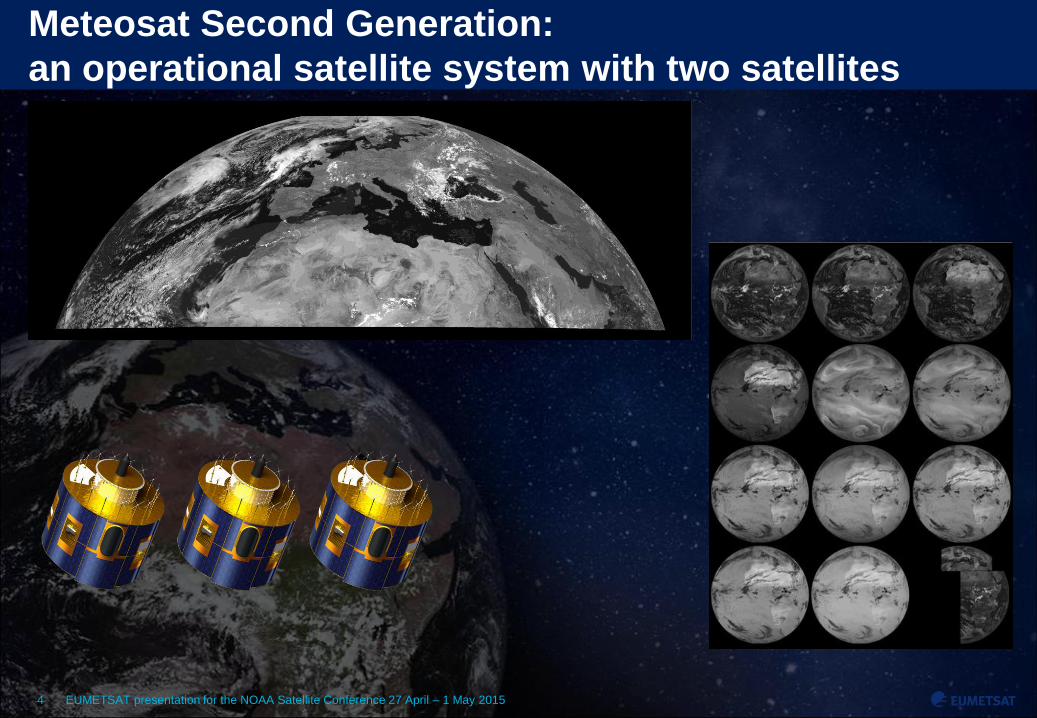
Meteosat Second Generation:
an operational satellite system with two satellites

5 EUMETSAT presentation for the NOAA Satellite Conference 27 April – 1 May 2015
The EUMETSAT Polar System is part of the Initial Joint
Polar System shared with the US

6 EUMETSAT presentation for the NOAA Satellite Conference 27 April – 1 May 2015
Major impact of Metop-B on Day 1 forecast
24.5%
RELATIVE CONTRIBUTION
OF OBSERVATIONS TO
REDUCTION OF ERROR IN
DAY 1 NUMERICAL FORECAST
T0 + 24h
Error Reduction

7 EUMETSAT presentation for the NOAA Satellite Conference 27 April – 1 May 2015
EUMETCast Users Worldwide as of 30 June 2014
4
3
2-10
11-50
51-200
201-500
1 User
500+
0 User
EUMETCast Americas
SES 6, C-BAND
EUMETCast Africa
EUTELSAT 5 WEST A, C-BAND
EUMETCast Europe
EUTELSAT 9 A, KU-BAND
Delivering to users worldwide in real time
2789 users in Member States 4 users in Cooperating State 3310 users world-wide

EUMETSAT presentation for the NOAA Satellite Conference 27 April – 1 May 2015 8
FUTURE EUMETSAT PROGRAMMES

9 EUMETSAT presentation for the NOAA Satellite Conference 27 April – 1 May 2015
Future programmes shape the 2018 – 2040 timeframe
Jason-CS : Proposed, open to subscription in Nov. 2014 Satellite development approved at ESA CMIN14
Recurrent satellite co-funded by European Union/Copernicus
EPS-SG : approval process started in July 2014 Metop-SG programme approved at ESA Council Sentinel-5 development approved at ESA Council Recurrent Sentinel-5 instruments funded by European Union/Copernicus
MTG: Approved, under development Sentinel-4 approved (2 instruments funded by ESA)

10 EUMETSAT presentation for the NOAA Satellite Conference 27 April – 1 May 2015
Primary mission: support nowcasting of high impact weather
Continuity and enhancement of MSG imagery services
Addition of a new lightning imaging capability
Introduction of an innovative infrared hyper-spectral
sounding mission: world premiere
Secondary mission: air quality monitoring over Europe
Synergy between Sentinel-4, IRS and imagery
6-satellite programme (4 MTG-I and 2 MTG-S) to cover 2019-40
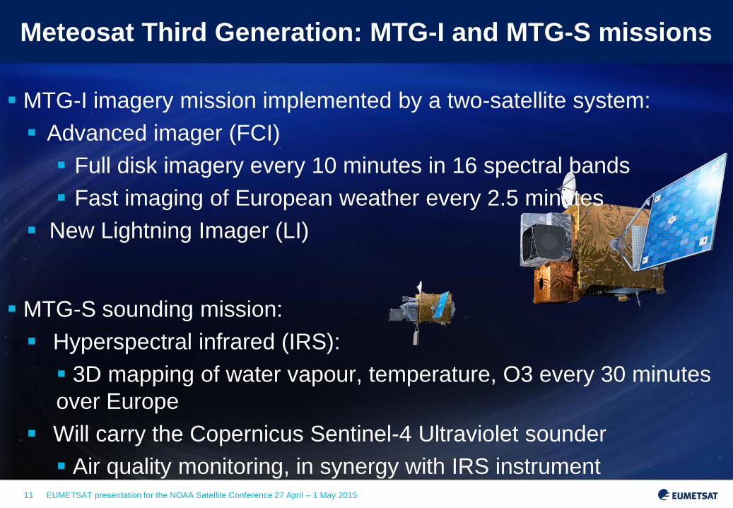
Meteosat Third Generation
11 EUMETSAT presentation for the NOAA Satellite Conference 27 April – 1 May 2015
MTG-I imagery mission implemented by a two-satellite system:
Advanced imager (FCI)
Full disk imagery every 10 minutes in 16 spectral bands
Fast imaging of European weather every 2.5 minutes
New Lightning Imager (LI)
MTG-S sounding mission:
Hyperspectral infrared (IRS):
3D mapping of water vapour, temperature, O3 every 30 minutes
over Europe
Will carry the Copernicus Sentinel-4 Ultraviolet sounder
Air quality monitoring, in synergy with IRS instrument
Meteosat Third Generation: MTG-I and MTG-S missions

12 EUMETSAT presentation for the NOAA Satellite Conference 27 April – 1 May 2015
EPS Second Generation
Primary mission: further improve observational inputs to
Numerical Weather Prediction models
Significant contributions to other real time applications
Nowcasting at high latitudes
Marine meteorology and operational
oceanography
Operational hydrology
Air quality monitoring
Climate monitoring: expand by 20+ years the climate data
records initiated in 2006 with EPS

13 EUMETSAT presentation for the NOAA Satellite Conference 27 April – 1 May 2015
EPS Second Generation
Continuation and enhancement of service from mid morning
polar orbit in 2021 – 2040
Twin satellite in-orbit configuration:
Metop-SG A: optical imagery and sounding mission
Flies the Copernicus Sentinel-5 instrument
Metop-SG B: microwave imaging mission
Two series of 3 successive satellites for 21 years of operations
European contribution to the Joint Polar System (JPS) shared
with the US/NOAA
14 EUMETSAT presentation for the NOAA Satellite Conference 27 April – 1 May 2015
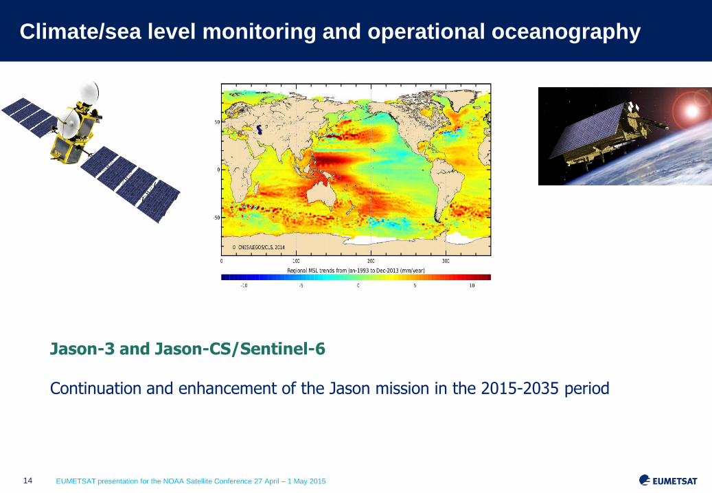
Climate/sea level monitoring and operational oceanography
Jason-3 and Jason-CS/Sentinel-6 Continuation and enhancement of the Jason mission in the 2015-2035 period

15 EUMETSAT presentation for the NOAA Satellite Conference 27 April – 1 May 2015
Oceanography: EUMETSAT to operate the marine mission
of GMES/Copernicus Sentinel-3 (2015-)
Sentinel-3
• SLSTR: Sea and Land Surface Temperature Radiometer
• OLCI: Ocean (and Land) Colour Instrument
• SRAL: Synthetic Aperture Radar Altimeter
• MWR: MicroWave Radiometer
• LRR: Laser Retro-Reflector
Ground Segment under integration at EUMETSAT premises

16 EUMETSAT presentation for the NOAA Satellite Conference 27 April – 1 May 2015
EUMETSAT Mission Planning: ocean monitoring

17 EUMETSAT presentation for the NOAA Satellite Conference 27 April – 1 May 2015
Jason-3/CS + Sentinel-3: an integrated Copernicus capability
Sentinel-3 (in blue) and Jason-3/-CS (white) orbital paths, superimposed on a
MyOcean sea surface temperature image.

EUMETSAT presentation for the NOAA Satellite Conference 27 April – 1 May 2015 18
NOAA EUMETSAT Co-operation
19 EUMETSAT presentation for the NOAA Satellite Conference 27 April – 1 May 2015
NOAA EUMETSAT Co-operation 1/4
1985: Temporary responsibility for the Data Collection System (DCS) which
Meteosat-1 had provided following the failure of the DCS on Meteosat-2 was
assumed by a US satellite, GOES-4, over the western Atlantic
1992: Exchange of letters between NOAA and EUMETSAT regarding the Atlantic
Data Coverage (ADC). At that time, a European geostationary satellite
(METEOSAT-3) started operations from a new position at 50°W to cover the
Atlantic upon request of NOAA
1993: Formalisation in a Backup Agreement and an Agreement on General
Cooperation, including training, scientific research
1995: Agreement on Access to images, covering exchange of data, data
distribution (NOAA is EUMETSAT data distributor for U.S. Territory).
Development of operational European – U.S. infrastructures to enable these
exchanges. Updated in 2003 to cover MSG.

20 EUMETSAT presentation for the NOAA Satellite Conference 27 April – 1 May 2015
NOAA EUMETSAT Co-operation 2/4
1998: Agreement on the development of an Initial Joint-Polar System (IJPS)
covering the exchange of instruments between Europe and U.S for 2 NOAA
POES satellites and 2 EUMETSAT Metop satellites.
2003: IJPS complemented by a Joint Transition Agreement to cover a third
EUMETSAT Metop satellite and paving the way for the development of a Joint
Polar System Agreement by 2015.
2004: Cooperation Agreement on training related to polar-orbiting satellite
meteorology
2006: IJPS complemented by a Data Denial Implementation Plan enabling U.S.
to deny access to data from its instruments flown on European satellites in
case of crisis or war.

21 EUMETSAT presentation for the NOAA Satellite Conference 27 April – 1 May 2015
NOAA EUMETSAT Co-operation 3/4
IJPS now includes Metop Data Acquisition from McMurdo and also Data
acquisition from Fairbanks in case of problems at Svalbard
The impact of Metop Antarctic Data Acquisition on forecasting has been significant
EUMETSAT cooperates with NOAA, CNES, NASA for Jason 2, and Jason 3
Currently EUMETSAT and NOAA are working closely on the consolidation of
common communications infrastructure
Direct Broadcast Network (DBNet) – interconnecting polar orbiting satellite data
received by USA and European direct broadcast reception stations
JPS Agreement text is now agreed on both sides and will be signed once the
EPS-SG Programme is approved in EUMETSAT

22 EUMETSAT presentation for the NOAA Satellite Conference 27 April – 1 May 2015
Real time U.S. S-NPP data service to MyOcean2 and
MACC-II Copernicus projects
S-NPP Svalbard
The European Commission’s GMES Initial Operations 2013 Work Programme includes an action provide data to the marine and atmosphere services (MyOcean2 and MACC-II) in gap resulting from the loss of ENVISAT until the start of Sentinel-3 operations. These data are provided from Suomi-NPP EUMETSAT’s existing relationship with NOAA has enabled EUMETSAT to access and redistribute Suomi-NPP data to Copernicus users on behalf of the European Commission MyOcean2 and EUMETSAT have identified the need for sea surface temperature (SST) and ocean colour products from VIIRS on Suomi-NPP. These products are acquired from NOAA and tailored to the precise user requirements before being made available in near real time via EUMETCast. Together with the MACC-II, the requirements for atmospheric composition products from S-NPP have also been defined and dissemination of these products via EUMETCast has been put in place.
23 EUMETSAT presentation for the NOAA Satellite Conference 27 April – 1 May 2015
NOAA EUMETSAT Co-operation 4/4
Cooperation in international Fora:
• Global Earth Observation System of Systems (GEOSS) (i.e. GEONETCast)
• Committee on Earth Observation Satellites (CEOS) (i.e. Constellation on Oceanography)
• Coordination Group of Meteorological Satellites (CGMS)
Future cooperation
• Continuation of the long and fruitful cooperation!
• In particular in operational oceanography (Jason follow-on and
long term strategy for operational oceanography measurements)