monitoring study group meeting minutescecentralsierra.ucanr.edu/files/101746.pdf · south lake...
TRANSCRIPT
1
Monitoring Study Group Meeting Minutes June 24, 2008
South Lake Tahoe—Angora Fire Field Meeting
The following people attended the MSG meeting: Jim Ostrowski (BOF), Trinda Bedrossian (CGS), John Munn (CAL FIRE), Syd Brown (CDPR), Rich Walker (CAL FIRE), Bill Short (CGS), Mike Delasaux (UCCE), Michele Dias (CFA), Gaylon Lee (SWRCB), Gail Baker (USFS), Andrew Subblefield (HSU), Andrea Stanley (LRWQCB), Mike Liquori (SWC), Joe Marzocco (TRPA), Scott Frazier (TRPA), Mike Thrush (SPI), Faith Goss (CAL FIRE), Gail Bakker (USFS), Laura Banlolce, Nathon Malcomb (CAL FIRE), Antja Thompson (Stanford Univ.), Kevin Kransnow (UCB), Jorge Orozco, Domi Fellers (Nevada Tahoe Conservation District), Thomas Sanford (Cal Poly SLO), Russ White (Cal Poly SLO), Drew Perkins (Cal Poly SLO), Jason Arnold (Nevada Fire Safe Council), Brian Hirt (TRPA), Kathy Murphy (USFS), Hugh Safford (USFS), Richard Vacirca (USFS), Russ Wigart (El Dorado Co.), Raph Townsend (UC Davis), Alan Heyvaert (DRI), Jacques Landy (US EPA), Linda Stone (LRWQCB), Christy Daugherty (CAL FIRE), Anne Holden (LRWQCB), Dan Sussman (LRWQCB), George Cella (LRWQCB), Sally Thompson, Doug Cushman (LRWQCB), Michael Wopat (CGS), Nancy Alvarez (USGS), Mike Vollimer (TRPA), Raina Patrocinio (League to Save Lake Tahoe), Richard Gienger (HWC/SSRC), Dennis Hall (CAL FIRE), Patricia Raggio (CDPR), Tina Schultz (CDPR), Anthony Toto (CVRWQCB), Lisa Gymer (DFG), Marty Hartzell (CVRWQCB), Kim Gorman (Nevada Tahoe Conservation District), Julia Dyer (CCRWQCB), Bethany Crews (CCRWQCB), Parker Wills (CCRWQCB), Kevin Faucher (CTM), Dan Keenan (Sierra Nevada Alliance), Taylor Farnum (LRWQCB), Steve McKelvy (LRWQCB), Tom Suk (LRWQCB), Alanna Worrell (LRWQCB), Kelly Huck (LRWQCB), Clay Brandow (CAL FIRE), Tom Hintz (CAL FIRE), Bill Keye (CLFA), Woody Loftis (NRCS), Susie Kocher (UCCE), Daylon Wade (CTC), Scott Carroll (CTC), Eric Just (CAL FIRE), and Pete Cafferata (CAL FIRE). Meeting Background Information Pete Cafferata began the meeting with a brief summary of the State Board of Forestry and Fire Protection Monitoring Study Group’s history and purpose. He stated that this is the fourth MSG field meeting, with past trips to western Mendocino County to view watercourse crossings (May 2004), Swanton Pacific Ranch to observe the Little Creek watershed study (March 2006), and the southern Sierra Nevada to learn about the Kings River Experimental Watershed (KREW) study (September 2007). While the MSG has been focused on studies documenting impacts of timber operations on water quality, there has been recent interest in wildfire impacts as well. In particular, the MSG’s Interagency Mitigation Monitoring Program (IMMP) Subcommittee has suggested that post-fire monitoring may be appropriate for future consideration as a potential interagency monitoring topic. Post-fire monitoring will continue to be discussed at future MSG and MSG IMMP subcommittee meetings. For those without earlier MSG exposure, past MSG reports, supported reports, meeting minutes, archived PowerPoints, and the MSG Strategic Plan are posted on the MSG website at: http://www.fire.ca.gov/CDFBOFDB/board/msg_geninfo.asp.

2
None of the usual MSG meeting topics (e.g., monitoring-related announcements, MSG subcommittee updates, FORPRIEM and TAC updates, etc.) were addressed at this meeting. The entire session was devoted to the 2007 Angora Fire and monitoring efforts currently underway to document its impacts on water quality. Ms. Susie Kocher, UC Cooperative Extension Natural Resources Advisor for the Lake Tahoe Basin, is monitoring of the recovery of the Angora fire area in collaboration with the California Tahoe Conservancy (CTC) and coordinated the meeting for the MSG. She led the field trip and the Board of Forestry and Fire Protection’s MSG extends our thanks to Susie for her efforts to make this a successful field meeting. There were four main presentations, with brief summaries of each provided below. Overview of the Angora Fire and USFS Fuel Treatment Effectiveness Ms. Kathy Murphy, USFS Fuels Operations Officer, provided a brief PowerPoint presentation prior to leading a discussion at the first field stop. She stated that it was the one year anniversary of the 3,100 acre Angora Fire and rapidly summarized a paper she authored titled “An Assessment of Fuel Treatment Effects on Fire Behavior, Suppression Effectiveness, and Structure Ignition on the Angora Fire”.1 Kathy stated that most of the fuel treatment areas reduced fire behavior from a crown fire to a surface fire and were effective in reducing fire intensity. She showed photos illustrating that a large number of houses burned from fire brands generated from other burning houses, rather than wildland fuels. This work demonstrated that to manage for low fire intensity on steeper slopes, more intensive fuel treatments are needed than on flat terrain. Kathy also stated that there was a rapid spread of fire and 100% mortality in the Angora Creek stream environment zone (SEZ) due to heavy fuel loading and a long, hot burning duration. In the field, Kathy showed the group an area where fuel treatment had occurred near a subdivision and was subsequently burned during the Angora Fire (Figure 1). While the pine tree boles were scorched, the majority of the trees have green foliage and survivability appears likely (Figure 2). Hugh Safford, USFS Ecologist, and Doug Cushman, Lahontan RWQCB, provided additional information at this field stop. Hugh informed the group that there is virtually no pine regeneration in the severely burned areas of the fire, since the fire burned before cone drop (only 15 seedlings recorded on 600 plots). Past fire frequency in this area ranged from 5 to 15 years prior to fire suppression efforts. There was considerable discussion regarding why SEZs have not been treated to reduce fire intensity. Doug discussed the complexities involved with proposed management in SEZs, as well as providing a brief overview of Lake Tahoe water quality concerns, congressional designation and funding in the Basin. Angora Creek Stream Channel Condition Monitoring Mr. Richard Vacirca, Aquatic Biologist for the USFS Lake Tahoe Basin Management Unit, explained stream channel condition monitoring work being undertaken to
1 This report is posted on the MSG website at: http://www.fire.ca.gov/CDFBOFDB/PDFS/Murphy_etal_2007_USFS_FuelsTreatmentEffectivenessStudy_Tahoe.pdf.
3
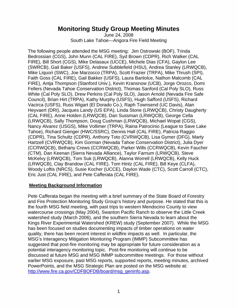
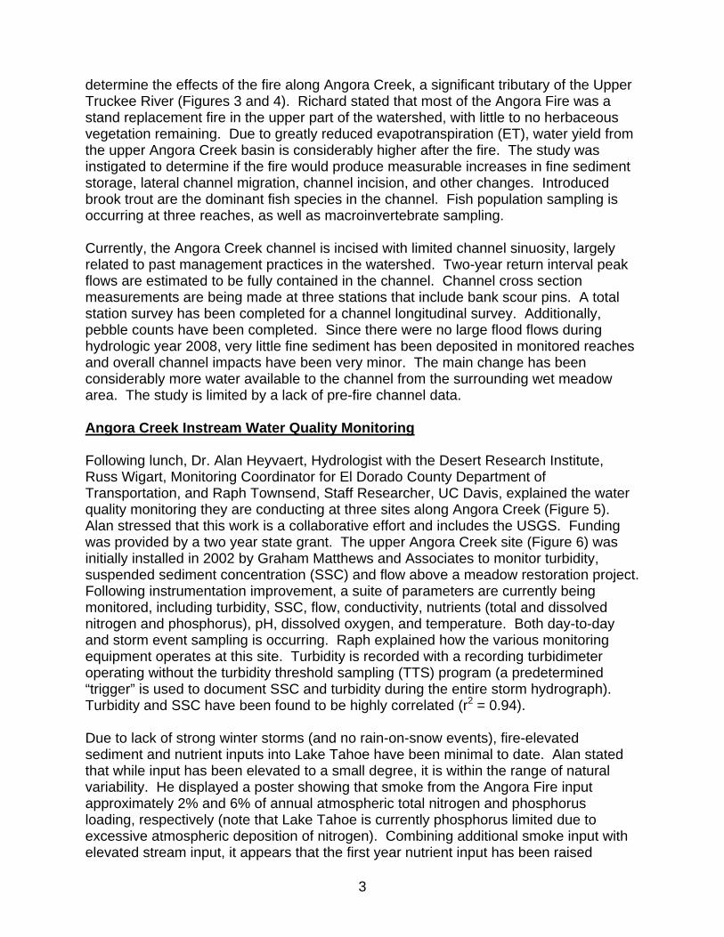
determine the effects of the fire along Angora Creek, a significant tributary of the Upper Truckee River (Figures 3 and 4). Richard stated that most of the Angora Fire was a stand replacement fire in the upper part of the watershed, with little to no herbaceous vegetation remaining. Due to greatly reduced evapotranspiration (ET), water yield from the upper Angora Creek basin is considerably higher after the fire. The study was instigated to determine if the fire would produce measurable increases in fine sediment storage, lateral channel migration, channel incision, and other changes. Introduced brook trout are the dominant fish species in the channel. Fish population sampling is occurring at three reaches, as well as macroinvertebrate sampling. Currently, the Angora Creek channel is incised with limited channel sinuosity, largely related to past management practices in the watershed. Two-year return interval peak flows are estimated to be fully contained in the channel. Channel cross section measurements are being made at three stations that include bank scour pins. A total station survey has been completed for a channel longitudinal survey. Additionally, pebble counts have been completed. Since there were no large flood flows during hydrologic year 2008, very little fine sediment has been deposited in monitored reaches and overall channel impacts have been very minor. The main change has been considerably more water available to the channel from the surrounding wet meadow area. The study is limited by a lack of pre-fire channel data. Angora Creek Instream Water Quality Monitoring Following lunch, Dr. Alan Heyvaert, Hydrologist with the Desert Research Institute, Russ Wigart, Monitoring Coordinator for El Dorado County Department of Transportation, and Raph Townsend, Staff Researcher, UC Davis, explained the water quality monitoring they are conducting at three sites along Angora Creek (Figure 5). Alan stressed that this work is a collaborative effort and includes the USGS. Funding was provided by a two year state grant. The upper Angora Creek site (Figure 6) was initially installed in 2002 by Graham Matthews and Associates to monitor turbidity, suspended sediment concentration (SSC) and flow above a meadow restoration project. Following instrumentation improvement, a suite of parameters are currently being monitored, including turbidity, SSC, flow, conductivity, nutrients (total and dissolved nitrogen and phosphorus), pH, dissolved oxygen, and temperature. Both day-to-day and storm event sampling is occurring. Raph explained how the various monitoring equipment operates at this site. Turbidity is recorded with a recording turbidimeter operating without the turbidity threshold sampling (TTS) program (a predetermined “trigger” is used to document SSC and turbidity during the entire storm hydrograph). Turbidity and SSC have been found to be highly correlated (r2 = 0.94). Due to lack of strong winter storms (and no rain-on-snow events), fire-elevated sediment and nutrient inputs into Lake Tahoe have been minimal to date. Alan stated that while input has been elevated to a small degree, it is within the range of natural variability. He displayed a poster showing that smoke from the Angora Fire input approximately 2% and 6% of annual atmospheric total nitrogen and phosphorus loading, respectively (note that Lake Tahoe is currently phosphorus limited due to excessive atmospheric deposition of nitrogen). Combining additional smoke input with elevated stream input, it appears that the first year nutrient input has been raised

4
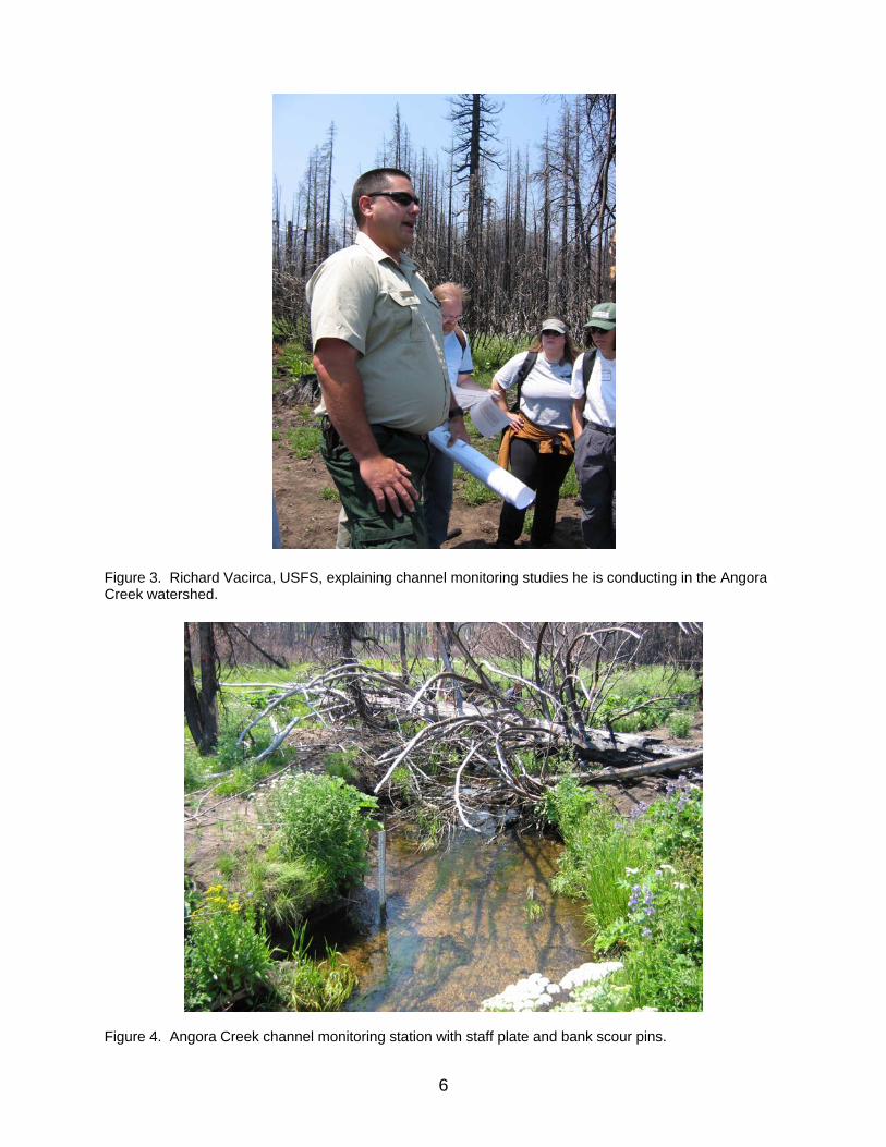
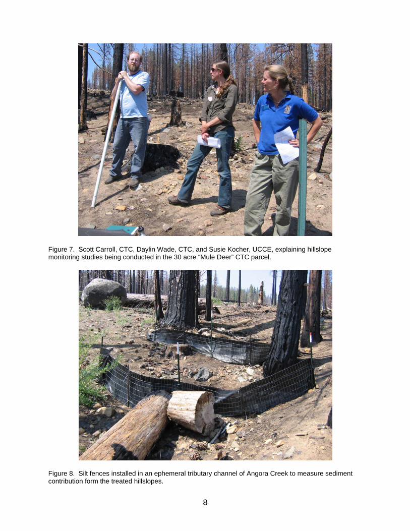
approximately 10%. Draft flow and turbidity data were circulated showing that peak turbidity readings during storm events have been only approximately 55 NTUs. The researchers stressed that the threat to the lake is not over, however, since large storms this coming winter could still input significant sediment and nutrient loads into Lake Tahoe. Angora Fire Hillslope Monitoring Studies The final field trip stop was the 30 acre “Mule Deer” CTC parcel that was clearcut following the Angora Fire (Figure 7). SPI completed the salvage logging with rubber tired skidders under an emergency contract with the CTC. Logging slash and small dead trees were masticated, with the ground up material spread over the hillslope. Jeffrey pine seedlings were planted at a rate of 200-300/acre and the slopes were reseeded with native forb species. Contour felled logs were also placed on the hillslope to reduce surface erosion. Susie Kocher, UCCE, explained that a suite of monitoring projects are taking place on this parcel, including soil strength measurement (an index of soil compaction) made with a recording cone penetrometer, silt fences, erosion pins, channel longitudinal profiles, and vegetation plots.2 The goal of the monitoring work is to evaluate the effectiveness of post-fire restoration treatments completed by the CTC. Objectives of the practices were to reduce soil erosion, accelerate forest recovery, and reduce fuel loading. Daylin Wade, Forestry Program Assistant with the CTC, explained how the silt fences were constructed last fall along a small ephemeral tributary of Angora Creek located within the 30 acre parcel. Three sets of fences were installed, each with two fences located about four feet apart to increase trapping efficiency (Figure 8). Following the spring of 2008, accumulated sediment was removed from all but one of the fences. Overall, 65 five gallon buckets of wet sediment was removed and weighed. Samples were taken to determine moisture content, which will allow the dry weight of the material removed to be determined. A unit area sediment production rate will be calculated and compared to estimates produced from the WEPP model (no control conditions were available within the burn area). Scott Carroll, CTC, covered the longitudinal profile survey work that has been conducted along the channel. The profile was shot last fall prior to winter storms and again this spring. The only small change noted to date has been where sediment has filled in behind coir logs that were installed in the channel after the original survey. A net filling of approximately 3.5 cubic yards has been recorded. No significant channel changes have occurred and filling behind the logs is likely natural erosion. Susie Kocher explained how the Rimik CP40 cone penetrometer operates to record soil strength. Measurements were taken at 39 plots after the fire, following treatment, and again in May/June 2008. Soil moisture content is also measured, since soil strength is related to moisture. Soil strength data will be analyzed to determine if there was a significant increase in soil compaction following treatment. Measurements will continue for five years.
2 The Angora Fire Restoration Monitoring Protocol is posted on the MSG website at: http://www.fire.ca.gov/CDFBOFDB/PDFS/California_Tahoe_Conservancy_Angora_Monitoring_Protocol_4-08.pdf.

5
Figure 1. Kathy Murphy, USFS, explaining how fuel treatment areas reduced fire behavior from a crown fire to a surface fire and were effective in reducing fire intensity.
Figure 2. Treated Jeffrey pine stand near a subdivision where fire intensity was reduced.
6
Figure 3. Richard Vacirca, USFS, explaining channel monitoring studies he is conducting in the Angora Creek watershed.
Figure 4. Angora Creek channel monitoring station with staff plate and bank scour pins.

7
Figure 5. Russ Wigart, El Dorado County, explaining water quality monitoring work being undertaken in Angora Creek. Dr. Alan Heyvaert, DRI, is located to the left of Mr. Wigart.
Figure 6. Water quality monitoring station on upper Angora Creek, including boom with recording turbidimeter and a half-round culvert used as a rated section for flow measurement.
8
Figure 7. Scott Carroll, CTC, Daylin Wade, CTC, and Susie Kocher, UCCE, explaining hillslope monitoring studies being conducted in the 30 acre “Mule Deer” CTC parcel.
Figure 8. Silt fences installed in an ephemeral tributary channel of Angora Creek to measure sediment contribution form the treated hillslopes.