mire is the model inventory of roadway elements … ridot_mire_presentation_v1.pdf · elements...
TRANSCRIPT


MIRE is the Model Inventory of Roadway Elements
Concerned largely with road safety
Provides guidelines for detailed descriptions of roadway attributes◦ Pavement and road descriptors, intersection
signalization, sidewalks and curbs, ramps


RIDOT wants MIRE data◦ HPMS reporting, Safety Analyst, Roads and
Highways integration and maintenance
ESRI’s Roads and Highways integration◦ RIDOT is looking to integrate MIRE data
◦ Using RCE to edit and maintain
◦ Storing MIRE Elements as events

Vans drive along predefined routes
Directionality is considered (primary vs secondary)
Various data sets with priorities (NHS vs Non-NHS vs local)
GPS tracks used to track collection


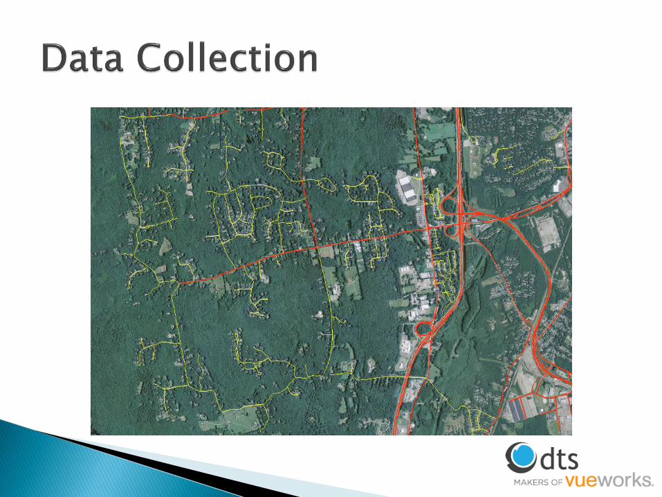


Data comes from various sources◦ Aerial imagery
◦ ROW van imagery
◦ LiDAR
Use GPS van tracks to track data collection◦ Date, run, van number entered into centerline file to
reference appropriate imagery for each segment


Recommended listing and
data dictionary of
traffic data elements
• 202 elements
Developed by the FHWA
Supports states’ HSIP
and other safety
programs

Michael Baker International
• MIRE Data Quality Control
- 5 Dataset Types
- 26 Datasets Delivered
Perform a Thorough Review of the MIRE Data Collection Guide
Define Areas with Potential for Data Inconsistencies
Evaluate Data using Manual and Automated Validation Techniques
Document and Report Conclusions / Recommendations

~26,000 Segments
~ 2,300 Miles
Interstate, U.S., and State Routes
105 Total Attributes:
Total Paved Surface Width (024)
Number of Through Lanes (031)
Outside Through Lane Width (032)
Inside Through Lane Width (033)
Many others…


~66,000 Segments
~ 4,600 Miles
105 Total Attributes:
Auxiliary Lane Presence/Type (035)
Presence/Type of Bicycle Facility (040)
Right Shoulder Type (043)
Median Barrier Type (056)
Right Sideslope (063)
Many others…

~16,200 Intersections
Intersections Associated with Approaches
17 Total Attributes:
Intersecting Angle (126)
Intersection Offset Distance (130)
Intersection Traffic Control (131)
Signalization Presence/Type (132)
Intersection Lighting (133)
Many others…

~49,000 Intersection
Approaches
Non-Spatial Geodatabase
Table
40 Total Attributes:
Approach Directional Flow (143)
Approach Mode (142)
Number of Approach Through Lanes (144)
Approach Traffic Control (154)

Ramp Dataset ~445 Ramps
25 Total Attributes:
Ramp Acceleration Lane Length (188)
Ramp Number of Lane (190)
Ramp Advisory Speed Limit (194)
Several others…

Quality Control Procedures
Manual Symbolization Techniques
Automated Validation via Customized Application

Manual Symbolization
Symbolize to detect large fluctuations in speed limit.
Speed Limit

Symbolize to detect changes in sidewalk presence.
Manual SymbolizationSidewalk Presence

Validate Against Guiderail Layer
1. Query opposing scenarios in guiderail layer and mainline layer.
2. Select by Location to detect segments with conflicting attributes.
Median Barrier Presence/Type

W-beam, Thrie Beam, Box Beam, and Rustic Beam guiderails that are defined as Semi-Rigid.
Locate these guiderails within 200 feet of a segment where Median Barrier Presence/Typedoes NOT equal Semi-Rigid. Median Barrier Type should be Semi-Rigid Barrier instead of
Rigid Barrier System.
Query mainline dataset for segment with Median Barrier Type equal to Unprotected.
Select by Location on unprotected segments within 200 feet of any existing guiderail. Median Barrier Type should be Semi-Rigid Barrier instead of
Unprotected.
Manual Symbolization
Median Barrier Presence/Type
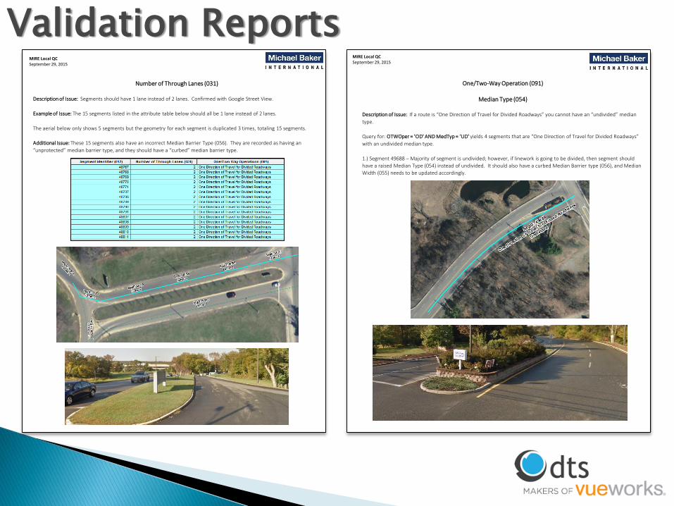
Validation ReportsMIRE Local QCSeptember 29, 2015
Number of Through Lanes (031)
Description of Issue: Segments should have 1 lane instead of 2 lanes. Confirmed with Google Street View.
Example of Issue: The 15 segments listed in the attribute table below should all be 1 lane instead of 2 lanes.
The aerial below only shows 5 segments but the geometry for each segment is duplicated 3 times, totaling 15 segments.
Additional Issue: These 15 segments also have an incorrect Median Barrier Type (056). They are recorded as having an
“unprotected” median barrier type, and they should have a “curbed” median barrier type.
MIRE Local QCSeptember 29, 2015
One/Two-Way Operation (091)
Median Type (054)
Description of Issue: If a route is “One Direction of Travel for Divided Roadways” you cannot have an “undivided” median
type.
Query for: OTWOper = 'OD' AND MedTyp = 'UD' yields 4 segments that are “One Direction of Travel for Divided Roadways”
with an undivided median type.
1.) Segment 49688 – Majority of segment is undivided; however, if linework is going to be divided, then segment should
have a raised Median Type (054) instead of undivided. It should also have a curbed Median Barrier type (056), and Median
Width (055) needs to be updated accordingly.

RIDOT Data Validation Tool
Developed validation rules based on MIRE Data Collection Guide
Checks may be run independently or grouped by type (cross, domain) or
dataset
Includes Checks for:
• Local
• Mainline
• Ramps
• Intersection
Approaches
• Intersections
• Intersection Join

RIDOT Data Validation Tool
Validation Types
• Cross
- 80 total
• Domain
- 90 total
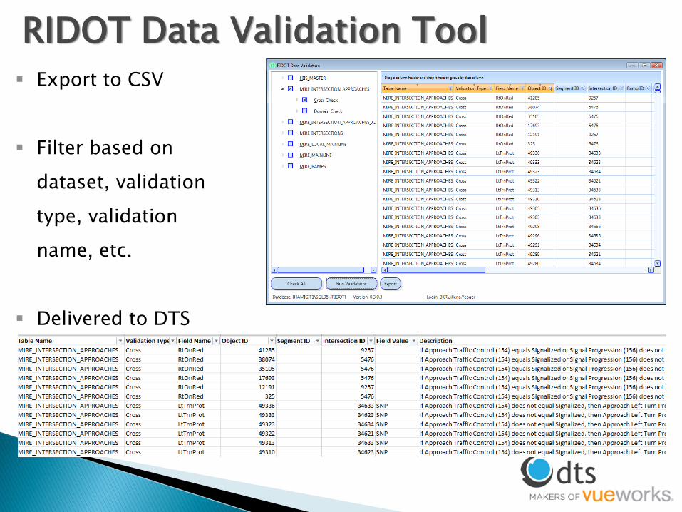
Export to CSV
Filter based on
dataset, validation
type, validation
name, etc.
Delivered to DTS
RIDOT Data Validation Tool

If Number of Through Lanes = 2 AND Operation = Two-Way, then Inside Through Lane Width must be 0 or NULL.
MIRE Guide states, “For a two-lane road, leave this element (Inside Through Lane Width) blank.”
Inside Through Lane
Inside Through Lane
Outside Through Lane
Outside Through Lane
Outside Through Lane
Outside Through Lane
Operation = 2 WayLanes = 2
No Inside Through Lanes
Operation = 2 WayLanes = 4
Valid Inside Through Lanes
Cross
ValidationLocal Dataset

If Intersection Junction Geometry equals T-
Intersection or Y-Intersection then
Intersection Number of Legs must equal 3.
If Intersection Junction Geometry equals Cross-
Intersection then Intersection Number of Legs must
equal 4.
If Intersection Junction Geometry equals Five or More
Legs then Intersection Number of Legs must equal > 5.
Cross
ValidationIntersection Dataset

If Approach Traffic Control equals…
• Stop Sign
• Yield Sign
• Uncontrolled
• Railroad Crossing Stop Sign Only
• Railroad Crossing Crossbucks Only
… then Signal Progression must equal No Signal.
Cross
Validation
Intersection Approach Dataset

Join the Intersection and Intersection Approach
tables on Intersection ID to query between
attribute tables.
If Intersection/Junction Traffic Control
equals Signalized (with ped signal) or
Signalized (w/o ped signal) then Approach
Traffic Control must equal Signalized.
Cross
ValidationIntersection & Approach Dataset

Benefits of Quality Data Consistency
• Compatible with Safety Analysis tools
Compare safety and non-safety data
Compare Data Over Time
Document
Assumptions
examples of interpretation
Anomalies
Reliability
Confidence in Data Driven Decisions

DOTs vs Consulting◦ Timelines and sense of urgency vary between
government and contractors
◦ Various iterations of centerline data from various sources within RIDOT
No standard data model for MIRE◦ Had to develop data model
◦ Numerous iterations to work out best geometric and attribute representations
◦ Built GDB with domains for all MIRE Elements that could be coded

Baseline MIRE data model for national standard consideration
Only agency to complete full MIRE data population
Full dataset for entire state of Rhode Island, consisting of over 6500 centerline miles
◦ RIDOT integration into R&H with RCE interface for maintenance and updates
◦ RIDOT needs to create event tables from MIRE Elements
◦ Contribute to standardized data model

RIDOT Team◦ Sean Raymond
HSIP Program Manager
◦ Shane White
Supervising GIS Specialist
◦ Stephen Kut
Asset Information Systems

Rafiq Basaria, GISP
Sr. GIS Analyst, DTS
(407) 382-5222
Tom Tiner, CP, GISP
Michael Baker International, Inc.
Dir of Transportation Asset Mgmt
609-807-9521