miocene geologic history of eastern santa catalina island, california
TRANSCRIPT
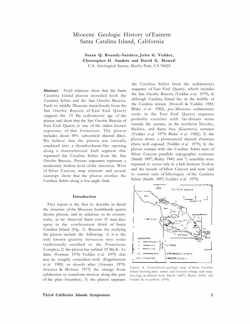


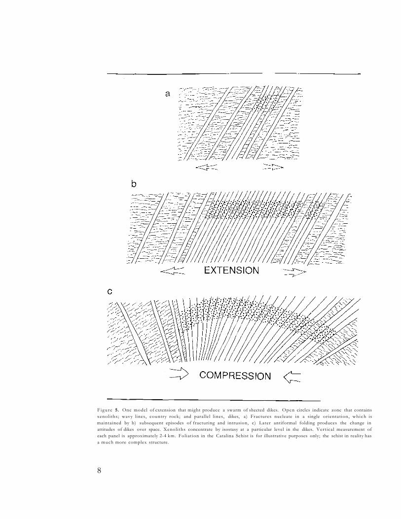
Figure 5. One model of extension that might produce a swarm of sheeted dikes. Open circles indicate zone that contains xenoliths; wavy lines, country rock; and parallel l ines, dikes, a) Fractures nucleate in a single orientat ion, wh ich is maintained by b) subsequent episodes of fracturing and intrusion, c) Later antiformal folding produces the change in attitudes of dikes over space. Xenol i ths concentrate by isostasy at a particular level in the dikes. Vert ical measurement of each panel is approximately 2-4 km. Fol iat ion in the Catalina Schist is for illustrative purposes only; the schist in reality has a much more complex structure.
8

Figure 6. Idealized models of extension that produces a swarm of dikes, such that different dikes have vary ing attitudes f rom the time of intrus ion. Symbols are the same as those used in Figure 5. a) Structure of the Comstock Lode , Nevada (Becker 1882); b) clay-cake experiment (Cloos 1971) to explain the pattern of faults around the G u l f of M e x i c o ; c) and d) hypothetical result of cont inued spreading of the clay cake and f i l l ing of fractures as they are produced. Result is a dike swarm produced by extension and intrusion, l imi ted assimilation, and upward transport and ejection of xenoliths. Xeno l i ths are most abundant in the zone where dips reverse. T h i s zone represents the area of ini t ia l extension where the greatest number of xenoliths and screens were created. Ver t ica l measurement of each panel is approximately 2-4 km.
9

Vedder & co-authors (1979). The structurally and stratigraphically(?) lower, probably older part of the sequence, which crops out at the nor th end of the quarry , is now large ly overgrown. The structurally higher southern part of the sequence is well exposed because it is actively being quarried, but the quality of exposures is reduced by a large proportion of dikes and fractures, and by massive slippage on the quarry face. However , accessibility has improved: a road now connects the quarry floor to the fire road on the ridge top.
This new road exposes an intrusive contact between the pluton and the San Onofre Breccia of East E n d Qua r r y . Par t of the contact appears to be between the San Onofre Breccia and the diapir ic , older part of the p lu ton , because the surface is very i r regu la r and bulbous, whereas dike surfaces wherever they are well exposed are subplanar. Subvertical and some subhorizontal dikes cross the contact between the diapir and its country rocks.
The quarry road also provides access to the top of the San Onof re Brecc i a . Clasts moderately high in the section include mostly greenschist, but upsection there is an increasing p ropor t ion of igneous clasts. T h e highest exposures (possibly down dropped in a fault block) show a mostly igneous breccia, with only a small fraction of 1 % of schist fragments. This strat igraphical ly highest outcrop provides support of a model of coeval plutonism and tectonism, since the only apparent source of igneous clasts available was the same pluton that intrudes the lower part of the breccia , or perhaps the volcanic carapace of this pluton.
The new quarry face exposes a fossil-bearing bed — the first positive bio-stratigraphic control on the age of any part of the East End Quarry sequence. The fossils occur in a lenticular massive grey sandstone in the San Onofre Breccia about 30 m above the present quarry floor. Easily accessible dislodged blocks on the quarry floor contain well-preserved molds of the pelecypod Miltha cf. sanctaecrucis (Arnold), which has a provisional age range of early to middle Miocene.
Faults and Interpretation of Faulting History
The southeastern portion of Santa Catalina Island has been deformed during several phases of tectonism that have taken place since the beginning of Miocene time. These different events are displayed in a variety of ways.
The San Onofre Breccia in East End Quarry is composed of angular clasts derived from the Catalina Schist and volcanic rocks in varying proportions. Some clasts are nearly 1 m long. We infer that this coarse breccia formed at or near a fault scarp, which formed during the first phase of tectonism, and is analogous to the V io l in Breccia of Crowell (1955) that formed along the San Gabriel fault zone (Crowell & Link 1982).
A second phase of t ec ton i sm a l lowed intrus ion of the quartz dior i t ic sheets that bloated the pluton. W o o d (1981) suggested that the sheets represent ring fractures around a caldera. Fractionation in such an environ ment would explain the felsic composition of the p lu ton . Howeve r , arcuate fractures or dikes that w o u l d be diagnost ic of such a se t t ing are not present . An a l te rnat ive hypothesis is that the sheets intruded in a transtensional environment, in such a way that in t rus ion was loca l i zed , trends of various sheets could vary by more than 90°, and sheets could be faulted, brecciated, then crosscut by later sheets. We favor the latter interpretation because it allows the format ion of a dike swarm and because it is compatible with what we know of the general tectonic history of the area.
If the variation of dike attitudes depicted in Figure 4 is the product of folding as shown in Figure 5, then this folding is the third phase of tectonism.
We infer that the fourth tectonic phase was the apparent low-angle faulting that placed the pluton over the Catalina Schist near the ridge top that trends west from the mouth of Silver Canyon. Although this apparent fault zone is generally obscured by landslides, the contact
10
between the p lu ton and the u n d e r l y i n g Catalina Schist generally follows topographic contours or dips shallower northward as far west as the west edge of the map (Fig. 3). T h e amount and direction of displacement along this low-angle fault are unconstrained. Smith (1897) evidently thought that this flat-lying contact was intrusive and, hence, inferred a laccolithic pluton. However, the many vertical dikes that provide much of the pluton's mass attest to a different form of intrusion.
T h e f i f th we l l - cons t r a i ned phase of tectonism is represented by the fault zone that passes through Haypress Reservoir and the western wall of Silver Canyon (Fig. 3). This fault zone is nearly straight and apparently dips steeply to the northwest . It seems to have a vertical component of movement, not only because it separates a part of the pluton that mostly lacks xenoliths on the northwest from a part of the p lu ton that contains abundant xenoliths on the southeast, but also because it separates the Catalina Schist overlain by pluton on the northwest from pluton and overlying volcanic rocks on the southeast (Fig. 4). The fault zone is about parallel to the principal trend of the quartz diorite sheets; however, the significance of this parallelism is not clear.
Many faults of small displacement and joints, cut the pluton into blocks a few meters on a side. These fractures seem almost random in their trends, but are generally steeply dipping.
Discussion
Data presented in this paper increase the constraints on both the age of the pluton and of the San Onofre Breccia of East End Quarry. The relationship between them requires that the pluton be young enough to intrude the San Onofre Breccia but old enough to contribute clasts to the breccia. Since the likely alteration mechanisms would reset K - A r ages downward, we regard 18.4 Ma (the younger end of the uncertainty in Forman's 1970 and Vedder et al.'s 1979 K - A r dates on the p lu ton ) as a minimum age for the pluton. Because 18.4 Ma
falls within the early part of the early to middle Miocene stratigraphic range of the species of Miltha found in the San Onofre Breccia, we can confidently pin the age of the diapir and dikes and the San Onofre Brecc ia of East E n d Quarry as being between about 22 Ma (the beginning of the range of Miltha sanctaecrucis) and 18.4 M a . This age range represents the oldest known time of depos i t ion of any exposure of the San Onofre Breccia. The 19 Ma age of the pluton represents the end of a poorly constrained period of igneous activity in the borderland that lasted from about 25-18 Ma (Palmer 1965; D. Bukry, written comm. 1976; Crowe et al. 1976; Paul et al. 1976;
Vedder & H o w e l l 1980; Howe l l & Vedder 1981; Vedder 1987).
T w o features of the p lu ton wh i ch have important tectonic implications are its contact relations and its sheeted character. Intrusion of the pluton separated the Catalina Schist from its erosional product, the San Onofre Breccia. The source for the breccia probably was a high-standing scarp along a major fault zone. Because of their s imi l a r i t y in age and composition, the dikes and the diapiric portion of the pluton are likely to be genetically related and in t ruded in an extens ional set t ing . Tectonic models of the California continental margin (Atwater 1970; Engebretson et al. 1985) suggest that the p lu ton in t ruded into a progressively developing rhombochasm-like opening or sigmoidal extensional bend in the nascent system of borderland transform faults that parallels the San Andreas fault zone (Fig. 7). The model of plutonism in a transtensional environment is based upon ideas by G. Gehrels (pers. comm. 1983) and Guineberteau & coauthors (1987). If the pluton is in roughly its original orientation, the trend of dikes is what one would expect for a rhombochasm in the San Andreas system. If, however, Luyendyk & co-authors (1985) analysis of 90° of clockwise rotation is correct, our model of intrusion into a zone of t rans tens ion wou ld require a s igmoida l extensional bend a long a more westward-trending segment in the San Andreas
11

Figure 7. a) Map view of a model for the opening of a transtensional rhombochasm, which might have allowed intrusion of the swarm of sheeted dikes now exposed as the pluton on Santa Catalina Island. Northwest-trending faults are part of the San Andreas fault system. No rotation since 19 M a . Paral le l l ines represent orientat ion of dikes, b) Mode l for opening of a sigmoidal releasing bend in a west-trending strand in the San Andreas fault system. After i n t ru s i on , this m o d e l w o u l d rotate 90° c lockwise , as hypothesized by Luyendyk & co-authors (1985). Parallel lines represent dike orientation. Length of each drawing is 10's km.
fault system, a segment of orientation about the same as the so-called big bend area east of Los Angeles.
The foregoing observations and interpre tations leave unanswered several fundamental questions: why was the opening beneath Santa Catalina Island filled from below with magma, whereas many other C e n o z o i c basins in southern Cal ifornia and the borderland, like Ridge Basin, were apparent ly f i l led more predominant ly from above w i th sediment? W h y does this setting of plutonic emplacement seem to be so rare? What was the source of magma: was it produced by adiabatic melting of crust through release of pressure? M igh t this in t rus ive event represent a last gasp of subduction-generated magma in this segment of the continental margin?
Summary and Conclusions
1. T h e 19 Ma p lu ton on Santa Cata l ina Island includes a high proportion (about 50%) of subvertical, dominantly northeast-trending dikes that locally reflect tectonic activity during
inf lat ion of the p luton. The mechanism of inflation is inferred to be similar to that which produces ophiol it ic dike swarms, although a primitive stage of the spreading seems to be represented by the pluton.
2. The pluton may represent intrusion into a propagat ing rhombochasm-l ike opening or sigmoidal extensional bend in a transtensional fault system.
3. A l t h o u g h the dikes genera l ly dip westward, they dip eastward in the western wall of Silver Canyon. This change in dip direction may be a primary feature or the product of later folding.
4. Xeno l i th s in the p luton general ly are restricted to a northeast-trending belt between Avalon and the mouth of Silver Canyon. The belt is truncated on the northwest by a fault and dies out to the southeast either because a xeno l i th h o r i z o n in the p l u ton dips southeastward or because the xenoliths mark the site where spreading began, or some other particular site in this extensional environment. Although some xenoliths lie outside this belt, they are a lmost invar i ab ly of igneous composition.
5. X e n o l i t h s in the belt are composed predominantly of lithologies of the Catalina Schist, w i th less vein quartz and rare San Onofre Breccia.
6. Intrusive relations, clast content, and presence of Miltha cf. sanctaecrucis (Arnold) in the San Onofre Breccia in East End Quarry constrain the breccia's age to being between about 22 and 18.4 M a , the oldest age of any dated outcrops of the formation.
7. Southeastern Santa Catalina Island has undergone much tectonic disruption since the beginning of Miocene time. Geologic responses to tectonism include uplift, deposition of sedimentary breccia, igneous activity, localized h igh-ang le and low-ang le fau l t ing , and widespread small-displacement faulting and jointing.
12

Acknowledgments
Our thanks to Doug Propst and the Santa Catalina Island Conservancy for continuing support of research programs on Santa Catalina Island. A special thanks to Te r r y M a r t i n , the Conservancy 's naturalist, for guidance on the island and for his interest and good company. R ick Mur r ay assisted Boundy-Sanders dur ing one v is i t to the island. Sorena Sorenson familiarized us with many aspects of the Ca ta l ina Schist . Discussions with T o m Wiley and reviews by H u g h M c L e a n , Peter W e i g a n d and Bob Bohannon greatly improved the manuscript. This research was supported in part by the U .S . Geolog ica l Survey's Pac i f i c -Ar i zona Crustal Experiment.
Literature Cited
Atwater, T. 1970. Implications of plate tectonics for
the C e n o z o i c e v o l u t i o n o f western N o r t h
America. Geol. Soc. Amer. Bull. 81:3513-3536.
and P. Molnar . 1973. Relative motion of the
Pacific and N o r t h American plates deduced from
sea-floor spreading in the At lant ic , Indian, and
South Pac i f i c oceans. Pp . 136-148. In: R . L .
Kovach and A. N u r (eds.), Proceedings of the
conference on t ec ton ic prob lems of the San
Andrea s fault system. S t an fo rd U n i v e r s i t y
Publications Geological Sciences, 13. 494 pp.
Ba i l ey , E . H . 1941. M i n e r a l o g y , pe t ro logy and
geology of Santa Cata l ina Island, Ca l i f o rn i a .
P h . D . d i s se r t a t ion (unpub l i shed ) , S t an fo rd
University, Palo Alto, CA. 193 pp.
Becker, G .F . 1882. Geology of the Comstock Lode
and the W a s h o e D i s t r i c t . U . S . G e o l . Surv .
M o n o g . 3:1-422.
Blake, M. C . , Jr . , D . G. Howel l and D. L .Jones. 1982.
Prel iminary tectonostratigraphic terrane map of
California. U.S. Geol. Surv. Open-file Rep. 82
593. Map with 9 pp text.
Cloos, E. 1971. Experimental analysis of Gu l f Coast
fracture patterns. Amer. Assoc. Petro. Geol . Bul l .
52:420-444.
Crowe, B . M . , H. McLean, D . G . Howell and R .E. Higgins . 1976. Petrography and major-element chemistry of the Santa Cruz Island Volcan ics . Pp. 196-216. In : D . G . Howe l l (ed.), Aspects of the G e o l o g i c H i s t o r y of the C a l i f o r n i a Cont inenta l Border land. Amer ican Associat ion of Petroleum Geologists, Pacific Section, Spec. Publ. 24. 561 pp.
C r o w e l l , J . C . 1955. Geology of the Ridge Basin area, Los Angeles and Ventura Counties, Ca l i forn ia . P p . 49 -52 . I n : R . H . J ahns (ed.), C h a p . I V (Structura l features) of geo logy of Southern Cal i fornia . Cal i fornia Div i s ion of Mines and Geology, Bull. 170. 59 pp.
and M . H . L i n k , (eds.) 1982. G e o l o g i c h i s tory o f R idge Bas in Southern C a l i f o r n i a . Soc i e ty o f E c o n o m i c Pa l eon to log i s t s and Mineralogists, Pacific Section. 292 pp.
Engebretson, D .C . , A. Cox and R .G. Gordon. 1985. Relative motions between oceanic and continental plates in the Pacific basin. Geol . Soc. Amer. , Spec. Pap. 206:1-64.
F o r m a n , J . A . 1970. Age of the Ca t a l ina Is land p lu ton , Ca l i fo rn i a . Pp . 37-45. in: O . L . Bandy (ed.), R a d i o m e t r i c da t ing and pa l eon to log i c zonation. Geologica l Society of Amer ica , Spec. Pap. 124. 247 pp.
G u i n e b e r t e a u , B . , J . - L . B o u c h e z and J . - L . Vigneresse. 1987. The Mortagne granite pluton (France) emplaced by pull-apart along a shear zone: structural and gravimetric arguments and regional implicat ion. Geol . Soc. Amer. Bul l . , 99:763-770.
H o w e l l , D . G . and J . G . Vedder . 1981. Structural imp l i c a t i on s o f s t ra t ig raphic d i scont inu i t i e s across the Sou the rn C a l i f o r n i a B o r d e r l a n d . P p . 53 5 -558 . In: W.G. E r n s t (ed.) , T h e geotectonic development of Ca l i fo rn i a . Ruby Volume 1. Prent i ce -Ha l l : Englewood Cl iffs , NJ. 706 pp.
Luyendyk, B .P . , M . J . Kamer l ing , R .R . Terres and J . S . Hornaf ius . 1985. Simple shear of Southern Ca l i fo rn i a dur ing Neogene t ime suggested by paleomagnet ic decl inat ions . J . Geophys . Res. 90(B14):12454-12466.
Palmer, H . D . 1965. Geology of Richardson Rock, n o r t h e r n C h a n n e l I s l ands , Santa Ba rba r a County, Ca l i forn ia . Geol . Soc. Amer. Bu l l . 76(10)4197-1202.
13

Pau l , R . C . , R . E . A r n a l , J . P . Bays inger , G . E . C l a y p o o l , J . L . H o l t e , C . M . Lubeck , J . M . Patterson, R .Z . Poore, R .L . Slettene, W. V. Sliter,
J . C . Taylor, R.B. Tudor and F.L. Webster. 1976. Geological and operational summary, Southern Cal i fornia Deep Strati graphic Test O C S - C A L 75-70, N o . 1, Cortes Bank area, offshore California. U.S . Geol . Surv. Open-file Rep. 76232. 65 pp.
Platt, J. P. 1976. The petrology, structure, and geologic history of the Catalina Schist terrain, Southern California. Univ. Calif. Pubs. Geol. Sci., 112 :1 -111 .
Shepard, F.P. , U.S. Grant and R.S. Dietz. 1939. The emergence of (Santa) Catalina Island. Amer. J. Sci. 237:651-655.
Smith, W . S . T . 1897. The geology of Santa Catalina Island. Proc. Calif. Acad. Sci. ( ser. 3) 1(1): 1-71.
Vedder, J. G. 1987. Regional geology and petroleum potential of the southern California borderland. Pp. 403-447. In:D.S. Scholl, A. Grantz, and J. G. Vedder (eds.), Geology and resource potential of the continental margin ofwestern North America
and adjacent ocean basins — Beaufort Sea to Baja Cal ifornia. Circum-Pacif ic Counci l for Energy and Mineral Resources, Earth Science Ser. 6.
and D . G . H o w e l l . 1980. T o p o g r a p h i c evolution of the Southern California Borderland during late Cenozoic time. Pp. 7-31. I n : D . M . Power (ed.), The California Islands: proceedings of a multidisciplinary symposium. Santa Barbara Museum of Natural History: Santa Barbara, CA. 787 pp.
, and J . A . Forman. 1979. Miocene strata and their relation to other rocks Santa Catalina Island, California. Pp. 239-256. I n : J . M . Armentrout, M . R . Cole and H. TerBest (eds.), Cenozoic paleogeography of the western United States. Society of Economic Paleontologists and Minera log i s t s , Pacif ic Sect ion, Pacif ic Coast Paleogeography Symp. 3. 335 pp.
W o o d , W . R . 1981. Geology , petrography, and geochemis t r y of the Santa Cata l ina Island volcanic rocks, Black Jack Peak to Whitleys Peak area. M .S . thesis (unpublished), California State University, Los Angeles, CA. 146 pp.
14