minutes of 353rd seac meeting dated...
TRANSCRIPT

Minutes of 353rd
SEAC Meeting Dated 29/08/2018
The 353rd
meeting of SEAC was held in Directorate of Environment, U.P. on
29/08/2018 following members were present in the SEAC:
1. Dr. (Prof.) S.N. Singh, Chairman
2. Dr. Sarita Sinha, Member
3. Dr. Virendra Mishra, Member
4. Dr. Pramod Kumar Mishra Member
5. Dr. Richpal Singh Sangu, Member
6. Dr. Ranjeet Kumar Dalela, Member
7. Dr. Ajoy Kumar Mandal Member
8. Shri Meraj Uddin, Member
The Chairman welcomed the members to the 353rd
SEAC meeting.
The SEAC unanimously took following decisions on the agenda points discussed:
1. Sand Mining at Yamuna River at Gata/Khand No.- 1 mi, 2mi, 5mi, 30mi, 31mi & 32mi,
Village-Yakootpur Tehsil-Sadar, Distt-Gautam Budh Nagar, (Area-7.18Ha) File No.
4398/ Proposal No.SIA/UP/MIN/75836/2018
A presentation was made by the project proponent along with their consultant M/s
Geogreen Enviro House Pvt. Ltd. The proponent, through the documents submitted and the
presentation made, informed the committee that :-
1- The environmental clearance is sought for Sand Mining at Yamuna River at Gata/Khand
No.- 1 mi, 2mi, 5mi, 30mi, 31mi & 32mi, Village-Yakootpur Tehsil-Sadar, Distt-Gautam
Budh Nagar, (Leased Area-7.18Ha).
2- Salient features of the project is as follows: 1. On Line Proposal No. SIA/UP/MIN/75836/2018
2. File No. Allotted By SEIAA, UP 4398
3. Name Of Proponent ShriSuyashJaiswal
4. Full Correspondence Address Of
Proponent And Mobile Number
R/o – Village Marvatiya, Pandey Bazar, District Basti, U.P.
5. Name Of Project Sand Mining at Yamuna River at Gata/Khand No.-1mi, 2mi, 5mi,
30mi, 31mi and 32mi, Village-Yakootpur, Tehsil-Sadar, District-
Gautam Buddha Nagar (Area 7.18 Ha)
6. Project Location (Plot/Khasra/Gata
No.)
Gata/Khand No.-1mi, 2mi, 5mi, 30mi, 31mi and 32mi, Village-
Yakootpur, Tehsil-Sadar, District-Gautam Buddha Nagar (Area 7.18 Ha)
7. Name Of River Yamuna
8. Name Of Village Yakootpur

Minutes of 353rd
SEAC Meeting Dated 29/08/2018
Page 2 of 36
9. Tehsil Sadar
10. District Gautam Buddha Nagar
11. Name Of Minor Mineral Sand
12. Sanctioned Lease Area In Ha 7.18 Ha
13. Mineable Area In Ha 7.18 Ha
14. Zero Level mRL 192 m
15. Max. &Min mRLWithin Lease Area Max-198.5 m; Min- 194.2m
16. Pillar Coordinates (Verified By DMO)
Point Latitude Longitude
A 28° 28„17.22 ‟‟ N 77° 24‟ 39.62‟'E
B 28° 28' 19.07‟‟ N 77° 24‟42.22‟'E
C 28° 28„15.45 ‟‟ N 77° 24‟ 42.02‟'E
D 28° 28' 13.03‟‟ N 77° 24‟52.17‟'E
E 28° 28' 07.81‟‟ N 77° 24‟ 52.03‟'E
F 28° 28' 10.73‟‟ N 77° 24‟ 35.60‟'E
17. Total Geological Reserve 1,70,717cubic meter
18. Total Mineable Reserve in LOI 1,07,700cubic meter
19. Total Proposed Production in 05 years 5,38,500cubic meter
20. Proposed Production/year 1,07,700cubic meter
21. Sanctioned Period Of Mine Lease 05 years
22. Production Of Mine/Day 431cubic meter
23. Method Of Mining Manual & Semi mechanized
24. No. Of Working Days 250
25. Working Hours/Day 08 hrs max, Day Time
26. No. Of Workers 50
27. No. Of VehiclesMovement/Day 32 trucks twice a day
28. Type Of Land Govt. /non forest
29. Ultimate Depth Of Mining 2.0m
30. Nearest Metalled Road From Site Noida - Greater Noida Expressway – 2.56 Km, NE
31. Water Requirement Water required for the project per day will be around 13.0 KLD (2.0
drinking purpose + 9.5 dust suppression and 1.5 for plantation) of
water supply will be from the village through tanker.
32. Name Of The QCI Accredited
Consultant With QCI No. And Period
Of Validity
GEOGREEN ENVIRO HOUSE PVT LTD
NABET/EIA/1720/IA0023
Valid till April‟2020
33. Any Litigation Pending Against The
Project Or Land In Any Court.
No
34. Details Of 500m Cluster Map &
Certificate Verified By Mining Officer
Letter No 1408 Dated04/05/2018issued by District Mining Officer,
GB Nagar confirms that there is no other mine lease in its vicinity.
35. Details Of Lease Area In Approved DSR
Page No.20 Table No.11
36. Proposed CSR Cost Rs. 3,10,750lakhs 37. Propose EMP Cost Rs. 6,28,500.00
38. Length And Breadth Of Haul Road 500.0 m x 6.0 m
39. No. of trees to be planted 50 per year
3- The mining would be restricted to unsaturated zone only above the phreatic water table
and will not intersect the ground water table at any point of time.
4- This project does not attract any of the general conditions applicable on mining projects
specified in EIA Notification 14/09/2006.
5- The mining operation will not be carried out in safety zone of any bridge or embankment
or in eco-fragile zone such as habitat of any wild fauna.
6- There is no litigation pending in any court regarding this project.
7- The project proposal falls under category–1(a) of EIA Notification, 2006 (as amended).
Minutes of 353rd
SEAC Meeting Dated 29/08/2018
Page 3 of 36
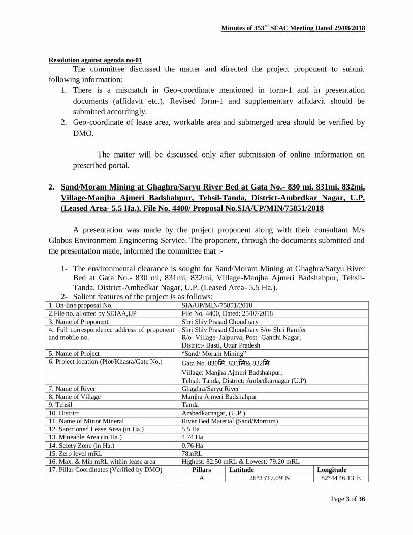
Resolution against agenda no-01
The committee discussed the matter and directed the project proponent to submit
following information:
1. There is a mismatch in Geo-coordinate mentioned in form-1 and in presentation
documents (affidavit etc.). Revised form-1 and supplementary affidavit should be
submitted accordingly.
2. Geo-coordinate of lease area, workable area and submerged area should be verified by
DMO.
The matter will be discussed only after submission of online information on
prescribed portal.
2. Sand/Moram Mining at Ghaghra/Saryu River Bed at Gata No.- 830 mi, 831mi, 832mi,
Village-Manjha Ajmeri Badshahpur, Tehsil-Tanda, District-Ambedkar Nagar, U.P.
(Leased Area- 5.5 Ha.). File No. 4400/ Proposal No.SIA/UP/MIN/75851/2018
A presentation was made by the project proponent along with their consultant M/s
Globus Environment Engineering Service. The proponent, through the documents submitted and
the presentation made, informed the committee that :-
1- The environmental clearance is sought for Sand/Moram Mining at Ghaghra/Saryu River
Bed at Gata No.- 830 mi, 831mi, 832mi, Village-Manjha Ajmeri Badshahpur, Tehsil-
Tanda, District-Ambedkar Nagar, U.P. (Leased Area- 5.5 Ha.).
2- Salient features of the project is as follows: 1. On-line proposal No. SIA/UP/MIN/75851/2018
2.File no. allotted by SEIAA,UP File No. 4400, Dated: 25/07/2018
3. Name of Proponent Shri Shiv Prasad Choudhary
4. Full correspondence address of proponent
and mobile no.
Shri Shiv Prasad Choudhary S/o- Shri Ramfer
R/o- Village- Jaipurva, Post- Gandhi Nagar,
District- Basti, Uttar Pradesh
5. Name of Project “Sand/ Moram Mining”
6. Project location (Plot/Khasra/Gate No.) Gata No. 830मि, 831मि& 832मि
Village: Manjha Ajmeri Badshahpur,
Tehsil: Tanda, District: Ambedkarnagar (U.P)
7. Name of River Ghaghra/Saryu River
8. Name of Village Manjha Ajmeri Badshahpur
9. Tehsil Tanda
10. District Ambedkarnagar, (U.P.)
11. Name of Minor Mineral River Bed Material (Sand/Morrum)
12. Sanctioned Lease Area (in Ha.) 5.5 Ha
13. Mineable Area (in Ha.) 4.74 Ha
14. Safety Zone (in Ha.) 0.76 Ha
15. Zero level mRL 78mRL
16. Max. & Min mRL within lease area Highest: 82.50 mRL & Lowest: 79.20 mRL
17. Pillar Coordinates (Verified by DMO) Pillars Latitude Longitude
A 26°33'17.09"N 82°44'46.13"E

Minutes of 353rd
SEAC Meeting Dated 29/08/2018
Page 4 of 36
B 26°33'17.96"N 82°44'57.47"E
C 26°33'23.96"N 82°44'57.49"E
D 26°33'22.73"N 82°44'45.57"E
18. Total Geological Reserves 1,63,356 m3
19. Total Mineable Reserves 1,01,194m3
20. Total Proposed Production (in five year) 4,67,500m3
21. Proposed Production/year in LOI 93,500m3/annum
22. Sanctioned Period of Mine lease 5 Years
23. Production of mine/day 374m3/day[561 T/day]
24. Method of Mining Opencast Semi-mechanized Method
25. No. of Working days 250 Days
26. Working hours/day 8 hours/day
27. No. Of Workers 38 Manpower
28. No. Of vehicles movement/day 56 Units
(Assumed Loading Capacity: 10 Tonnes/Unit)
29. Type of Land State Government Land
30. Ultimate Depth of Mining 2.0m
31. Nearest metalled road from site Rajesultanpur-Tanda Road, 3.0 km, SW
32. Water Requirement Surface Purpose Detail Avg.
Demand/
Day
Portable
Tanker
Drinking
@15lpcd/
worker
38 x 15 = 570
lpcd
0.6 KLD
Surface Water
Land reclamation/plantation
@5 Lit/Tree
30 Trees (30x5) = 150 lpcd
0.15 KLD
Dust suppression
@2 Lit/Sq.m
Haul Road Area
=(1200 m Length
x
6mWidth=200m2
)
= 14400 lpcd
14.4
KLD
Total 15.15
KLD
33. Name of QCI Accredited Consultant with QCI No and period of validity.
Globus Environment Engineering Services, Certificate No. NABET/EIA/1821/IA0034,
Valid Till April03/2021
34. Any litigation pending against the project
or hand in any court
No
35. Details of 500 m Cluster Map &
certificate issued by Mining Officer
Cluster certificate issued by DMO Ambedkar Nagar.
Letter No. 469/खनन-अनभुाग/क्लस्टरप्रमाणपत्र/18-19, Dated
16.07.2018
36. Details of Lease Area in approved DSR Page No: 48, Table No: 20, Sr. No: 12
37. Total Proposed Project Cost Rs. 27.47 Lakhs
38. Proposed CER cost Rs. 1.37 Lakhs
39. Proposed EMP cost Rs. 3.75 Lakhs (Haulage Road repair, Dust Suppression &
Plantation)
40. Length and breadth of Haul Road Haul Road Length 1.2 km &Haul Road Width 6 m
41. No. of Trees to be Planted 150 Trees (in Five Year)
3- The mining would be restricted to unsaturated zone only above the phreatic water table
and will not intersect the ground water table at any point of time.
4- This project does not attract any of the general conditions applicable on mining projects
specified in EIA Notification 14/09/2006.
Minutes of 353rd
SEAC Meeting Dated 29/08/2018
Page 5 of 36
5- The mining operation will not be carried out in safety zone of any bridge or embankment
or in eco-fragile zone such as habitat of any wild fauna.
6- There is no litigation pending in any court regarding this project.
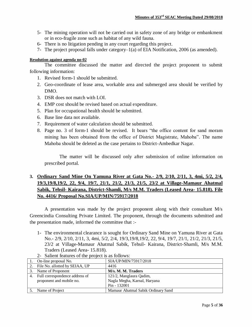
7- The project proposal falls under category–1(a) of EIA Notification, 2006 (as amended).
Resolution against agenda no-02
The committee discussed the matter and directed the project proponent to submit
following information:
1. Revised form-1 should be submitted.
2. Geo-coordinate of lease area, workable area and submerged area should be verified by
DMO.
3. DSR does not match with LOI.
4. EMP cost should be revised based on actual expenditure.
5. Plan for occupational health should be submitted.
6. Base line data not available.
7. Requirement of water calculation should be submitted.
8. Page no. 3 of form-1 should be revised. It bears “the office content for sand moram
mining has been obtained from the office of District Magistrate, Mahoba”. The name
Mahoba should be deleted as the case pertains to District-Ambedkar Nagar.
The matter will be discussed only after submission of online information on
prescribed portal.
3. Ordinary Sand Mine On Yamuna River at Gata No.- 2/9, 2/10, 2/11, 3, 4mi, 5/2, 2/4,
19/3,19/8,19/2, 22, 9/4, 19/7, 21/1, 21/2, 21/3, 21/5, 23/2 at Village-Mamaur Ahatmal
Sabik, Tehsil- Kairana, District-Shamli, M/s M.M. Traders (Leased Area- 15.818). File
No. 4416/ Proposal No.SIA/UP/MIN/75917/2018
A presentation was made by the project proponent along with their consultant M/s
Greencindia Consulting Private Limited. The proponent, through the documents submitted and
the presentation made, informed the committee that :-
1- The environmental clearance is sought for Ordinary Sand Mine on Yamuna River at Gata
No.- 2/9, 2/10, 2/11, 3, 4mi, 5/2, 2/4, 19/3,19/8,19/2, 22, 9/4, 19/7, 21/1, 21/2, 21/3, 21/5,
23/2 at Village-Mamaur Ahatmal Sabik, Tehsil- Kairana, District-Shamli, M/s M.M.
Traders (Leased Area- 15.818).
2- Salient features of the project is as follows: 1. On-line proposal No. SIA/UP/MIN/75917/2018
2. File No. allotted by SEIAA, UP 4416
3. Name of Proponent M/s. M. M. Traders
4. Full correspondence address of
proponent and mobile no.
121/2, Manglaura Qadim,
Nagla Megha, Karnal, Haryana
Pin - 132001
5. Name of Project Mamaur Ahatmal Sabik Ordinary Sand

Minutes of 353rd
SEAC Meeting Dated 29/08/2018
Page 6 of 36
Deposit On Yamuna River.
6. Project location (Plot/Khasra/Gata No.) Village - Mamaur Ahatmal Sabik,
Gata No. 2/9, 2/10, 2/11, 3, 4 mi, 5/2,2/4, 19/3, 19/8, 19/2, 22,9/4,
19/7, 21/1, 21/2, 21/3,21/5, 23/2
Tehsil- Kairana, District- Shamli of Uttar Pradesh.
7. Name of River Yamuna River
8. Name of Village Mamaur Ahatmal Sabik
9. Tehsil Kairana
10. District Shamli
11. Name of Minor Mineral Ordinary Sand
12. Sanctioned Lease Area (in Ha.) 15.818 Ha.
13. Mineable Area (in Ha.) 11.589 Ha.
14. Zero level mRL 227 m
15. Max. & Min mrl within lease area 234-228 m.
16. Pillar Coordinates (Verified by DMO) Point Latitude Longitude
A 29°21'49.19"N 77° 8'11.14"E
B 29°21'53.11"N 77° 8'25.98"E
C 29°21'46.18"N 77° 8'21.46"E
D 29°21'44.20"N 77° 8'18.74"E
E 29°21'43.22"N 77° 8'19.99"E
F 29°21'40.70"N 77° 8'18.37"E
G 29°21'40.41"N 77° 8'20.66"E
H 29°21'38.19"N 77° 8'20.61"E
I 29°21'31.81"N 77° 8'20.35"E
J 29°21'30.79"N 77° 8'16.71"E
K 29°21'31.65"N 77° 8'16.21"E
L 29°21'30.81"N 77° 8'12.66"E
M 29°21'34.55"N 77° 8'7.84"E
N 29°21'37.40"N 77° 8'8.00"E
O 29°21'37.44"N 77° 8'11.01"E
P 29°21'39.27"N 77° 8'10.45"E
Q 29°21'46.06"N 77° 8'11.78"E
17. Total Geological Reserves 4,63,560m3
18. Total Mineable Reserves in LOI 2,37,270m3
19. Total Proposed Production 11,86,350m3
20. Proposed Production/year 2,37,270m3
21. Sanctioned Period of Mine lease 5 Years
22. Production of mine/day 949.08 m3/Day
23. Method of Mining Opencast Semi-mechanized mining
24. No. of working days 250 days/ Year
25. Working hours/day 12 Hours
26. No. Of workers 70
27. No. Of vehicles movement/day 106
28. Type of Land Govt. Land
29. Ultimate Depth of Mining 2.5 m
30. Nearest metalled road from site 332 m
31. Water Requirement PURPOSE REQUIREMENT (KLD)
Drinking 0.70
Suppression of dust 1.59
Plantation 3.37
Others (if any) 0.00
Total 5.66
32. Name of QCI Accredited Consultant
with QCI No and period of validity.
GreencIndia Consulting Pvt Ltd. NABET/EIA/1619/RA0058 valid
till 27/10/2019

Minutes of 353rd
SEAC Meeting Dated 29/08/2018
Page 7 of 36
33. Any litigation pending against the
project or land in any court
No
34. Details of 500 m Cluster Map &
certificate verified by Mining Officer
185/ Kha. B.-2018, Dated: 08th May, 2018.
35. Details of Lease Area in approved
DSR
15.818 Hectares
36. Length and breadth of Haul Road Length 332 m, Width 6.0 m
3- The mining would be restricted to unsaturated zone only above the phreatic water table
and will not intersect the ground water table at any point of time.
4- This project does not attract any of the general conditions applicable on mining projects
specified in EIA Notification 14/09/2006.
5- The mining operation will not be carried out in safety zone of any bridge or embankment
or in eco-fragile zone such as habitat of any wild fauna.
6- There is no litigation pending in any court regarding this project.
7- The project proposal falls under category–1(a) of EIA Notification, 2006 (as amended).
Resolution against agenda no-03
The committee discussed the matter and directed the project proponent to submit
following information:
1. Permission letter from Irrigation Department for construction of temporary bridge should
be submitted.
2. Geo-coordinate of lease area, workable area and submerged area should be verified by
DMO.
3. Revised form-1 should be submitted.
4. Baseline data should be submitted including analytical test report number.
5. Soil quality parameters such as pH, organic carbon and organic matter should be
rechecked.
6. CER should be revised.
7. Change in EMP cost with reference to occupational health and green belt development
should be submitted.
The matter will be discussed only after submission of online information on
prescribed portal.
4. Sand Mining Project in Ghaghra River at Gata No.-2 Mi at Village- Baluwa Bhawani
Bux, Tehsil- Sagri, District-Azamgarh, U.P., (Leased Area:5.810Ha). File No. 4263/
Proposal No.SIA/UP/MIN/74772/2018
A presentation was made by the project proponent along with their consultant M/s
Cognizance Research India Pvt. Ltd. The proponent, through the documents submitted and the
presentation made, informed the committee that :- 1- The environmental clearance is sought for Sand Mining Project in Ghaghra River at Gata
No.-2 Mi at Village- Baluwa Bhawani Bux, Tehsil- Sagri, District-Azamgarh, U.P.,
(Leased Area: 5.810 Ha).

Minutes of 353rd
SEAC Meeting Dated 29/08/2018
Page 8 of 36
2- Salient features of the project is as follows: 1. On-line proposal No. SIA/UP/MIN/74772/2018 dated 26th April 2018
2. File No. allotted by SEIAA, UP 4263
3. Name of Proponent Sh. Aditya Singh
4. Full correspondence address of proponent and mobile no.
R/o- Village Lashirampur, Tehsil – Sadar, District – Azamgarh, Uttar Pradesh
5. Name of Project Riverbed Sand Mining
6. Project location (Plot/Khasra/Gata No.) Gata No. 2 मि0
7. Name of River River Ghaghra
8. Name of Village Balua Bhawani Bux
9. Tehsil Tehsil- Sagri
10. District District- Azamgarh, Uttar Pradesh
11. Name of Minor Mineral Ordinary sand
12. Sanctioned Lease Area (in Ha. ) 5.810ha
13. Mineable Area (in Ha. ) 5.810 ha
14. Zero level mRL 73.0 mRL
15. Max. & Min mrl within lease area 80.0 mRL & 76.0 mRL
16. Pillar Coordinates (Revised and Verified) PILLAR Latitude Longitude
A 26o 22‟41.4” N 83o 08‟43.9”E
B 26o 22‟38.2” N 83o 08‟37.6”E
C 26o 22‟48.9” N 83o 08‟34.4”E
D 26o 22‟50.6” N 83o 08‟41.0”E
17. Total Geological Reserves 1,76,968 m3/ 2,65,452 MT
18. Total Mineable Reserves in LOI 58,100 m3 / Year ; 87,150 TPA
19. Total Proposed Production (in five year) 2,90,500 m3 / 4,35,750 TPA
20. Proposed Production/year 58,100 m3 (87,150 TPA)
21. Sanctioned Period of Mine lease 5 years
22. Production of mine/day 232 m3/day
23. Method of Mining Opencast Semi-Mechanized
24. No. of working days 250
25. Working hours/day 12 hours (In two Shifts)
26. No. Of workers 50
27. No. Of vehicles movement/day Truck dumpers/tipper,Trackor Trolleys & other light
vehicles
28. Type of Land Riverbed of Ghaghra (Land on Lease issued by DM
Govt. of UP)
29. Ultimate Depth of Mining 1.2 m
30. Nearest metalled road from site 800 m from the riverbed
31. Water Requirement PURPOSE REQUIREMENT (KLD)
Drinking 0.50 KLD
Suppression of dust 4.80 KLD
Plantation 0.60 KLD
Others (if any) --
Total 5.90 KLD
32. Name of QCI Accredited Consultant with QCI No
and period of validity.
Cognizance Research India Pvt. Ltd.
QCI-NABET 1619/IA006, Valid 31st Jan 2019
33. Any litigation pending against the project or land in
any court
No
34. Details of 500 m Cluster Map & certificate issued
by Mining Officer
Letter No. Letter No. 99/khanan dated. 09-04-2018
35. Details of Lease Area in approved DSR DSR is available (A copy of letter of SDM is enclosed)
36. Proposed CER cost @ 5% of total project cost Rs. 2,50,000/- (Total Project Cost is 50 Lakh)
37. Proposed EMP cost Rs. 2,50,000/

Minutes of 353rd
SEAC Meeting Dated 29/08/2018
Page 9 of 36
38. Length and breadth of Haul Road Length – 0.80 Km , width 6 m
39. No. of Trees to be Planted 200 Plants in five years (Tentative)
3- The mining would be restricted to unsaturated zone only above the phreatic water table
and will not intersect the ground water table at any point of time.
4- This project does not attract any of the general conditions applicable on mining projects
specified in EIA Notification 14/09/2006.
5- The mining operation will not be carried out in safety zone of any bridge or embankment
or in eco-fragile zone such as habitat of any wild fauna.
6- There is no litigation pending in any court regarding this project.
7- The project proposal falls under category–1(a) of EIA Notification, 2006 (as amended).
Resolution against agenda no-04
The committee discussed the matter and directed the project proponent to submit
following information:
1. Revised CER should be submitted.
2. Revised EMP should be submitted with breakup of all remedial measures.
3. Reference source of plant species mitigating air pollution should be mentioned.
The matter will be discussed only after submission of online information on
prescribed portal.
5. Riverbed "Sand Mining" Project from Ghaghra River at Gata No.-676 mi, 677 mi,
678 mi, 682 mi, 683 mi, 777, 776 mi, 775 mi, 774 mi, 688 mi, 689 mi, 690 mi, 770 mi, 769
mi, 768 mi, 767 mi, 772, 771, 766 mi, 773 mi, 778 mi at Village -Botaha, Tehsil -
Ghanghata, District-SantKabir Nagar, (Leased Area - 10.585 Ha.) File No. 4332/
Proposal No.SIA/UP/MIN/75357/2018
A presentation was made by the project proponent along with their consultant M/s
Cognizance Research India Pvt. Ltd. The proponent, through the documents submitted and the
presentation made, informed the committee that :-
1- The environmental clearance is sought for Riverbed "Sand Mining" Project from
Ghaghra River at Gata No.-676 mi, 677 mi, 678 mi, 682 mi, 683 mi, 777, 776 mi, 775
mi, 774 mi, 688 mi, 689 mi, 690 mi, 770 mi, 769 mi, 768 mi, 767 mi, 772, 771, 766 mi,
773 mi, 778 mi at Village -Botaha, Tehsil - Ghanghata, District-SantKabir Nagar,
(Leased Area - 10.585 Ha.).
2- Salient features of the project is as follows: 1. On-line proposal No. SIA/UP/MIN/75357/2018; dated 09th June 2018
2. File No. allotted by SEIAA, UP 4332
3. Name of Proponent Sh. Bali Ram Yadav, S/o Sh. Ram Daud
4. Full correspondence address of proponent and
mobile no.
R/o- Village & Post Tamakhas, Tehsil Khalilabad,
District Sant Kabir Nagar, UP
5. Name of Project Riverbed Sand Mining
6. Project location (Plot/Khasra/Gata No.) Gata No. 676 मि0, 677 मि0, 678 मि0, 682 मि0, 683 मि0,
777, 776 मि0, 775 मि0, 774 मि0, 688 मि0, 689 मि0, 690
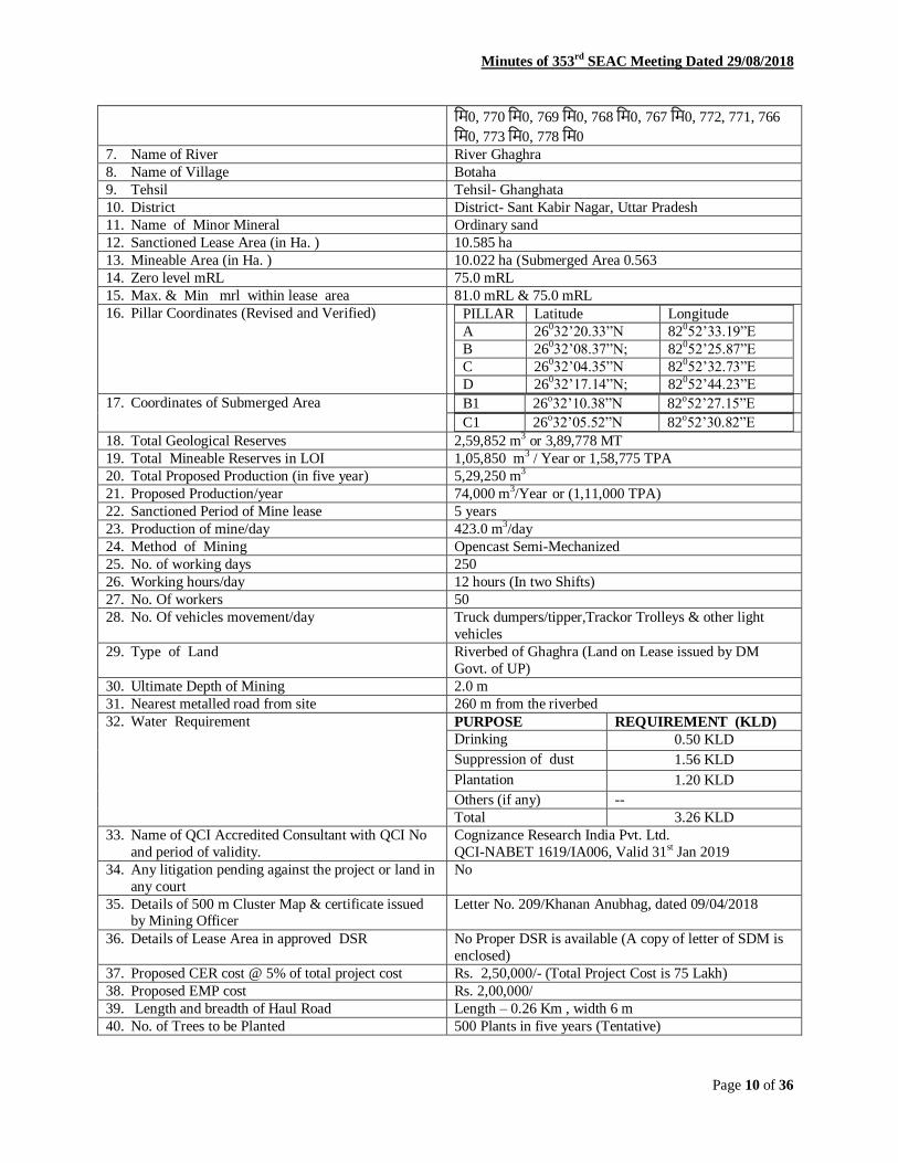
Minutes of 353rd
SEAC Meeting Dated 29/08/2018
Page 10 of 36
मि0, 770 मि0, 769 मि0, 768 मि0, 767 मि0, 772, 771, 766
मि0, 773 मि0, 778 मि0
7. Name of River River Ghaghra
8. Name of Village Botaha
9. Tehsil Tehsil- Ghanghata
10. District District- Sant Kabir Nagar, Uttar Pradesh
11. Name of Minor Mineral Ordinary sand
12. Sanctioned Lease Area (in Ha. ) 10.585 ha
13. Mineable Area (in Ha. ) 10.022 ha (Submerged Area 0.563
14. Zero level mRL 75.0 mRL
15. Max. & Min mrl within lease area 81.0 mRL & 75.0 mRL
16. Pillar Coordinates (Revised and Verified) PILLAR Latitude Longitude
A 26032‟20.33”N 82052‟33.19”E
B 26032‟08.37”N; 82052‟25.87”E
C 26032‟04.35”N 82052‟32.73”E
D 26032‟17.14”N; 82052‟44.23”E
17. Coordinates of Submerged Area B1 26o32‟10.38”N 82
o52‟27.15”E
C1 26o32‟05.52”N 82o52‟30.82”E
18. Total Geological Reserves 2,59,852 m3 or 3,89,778 MT
19. Total Mineable Reserves in LOI 1,05,850 m3 / Year or 1,58,775 TPA
20. Total Proposed Production (in five year) 5,29,250 m3
21. Proposed Production/year 74,000 m3/Year or (1,11,000 TPA)
22. Sanctioned Period of Mine lease 5 years
23. Production of mine/day 423.0 m3/day
24. Method of Mining Opencast Semi-Mechanized
25. No. of working days 250
26. Working hours/day 12 hours (In two Shifts)
27. No. Of workers 50
28. No. Of vehicles movement/day Truck dumpers/tipper,Trackor Trolleys & other light
vehicles
29. Type of Land Riverbed of Ghaghra (Land on Lease issued by DM
Govt. of UP)
30. Ultimate Depth of Mining 2.0 m
31. Nearest metalled road from site 260 m from the riverbed
32. Water Requirement PURPOSE REQUIREMENT (KLD)
Drinking 0.50 KLD
Suppression of dust 1.56 KLD
Plantation 1.20 KLD
Others (if any) --
Total 3.26 KLD
33. Name of QCI Accredited Consultant with QCI No
and period of validity.
Cognizance Research India Pvt. Ltd.
QCI-NABET 1619/IA006, Valid 31st Jan 2019
34. Any litigation pending against the project or land in
any court
No
35. Details of 500 m Cluster Map & certificate issued by Mining Officer
Letter No. 209/Khanan Anubhag, dated 09/04/2018
36. Details of Lease Area in approved DSR No Proper DSR is available (A copy of letter of SDM is
enclosed)
37. Proposed CER cost @ 5% of total project cost Rs. 2,50,000/- (Total Project Cost is 75 Lakh)
38. Proposed EMP cost Rs. 2,00,000/
39. Length and breadth of Haul Road Length – 0.26 Km , width 6 m
40. No. of Trees to be Planted 500 Plants in five years (Tentative)

Minutes of 353rd
SEAC Meeting Dated 29/08/2018
Page 11 of 36
3- The mining would be restricted to unsaturated zone only above the phreatic water table
and will not intersect the ground water table at any point of time.
4- This project does not attract any of the general conditions applicable on mining projects
specified in EIA Notification 14/09/2006.
5- The mining operation will not be carried out in safety zone of any bridge or embankment
or in eco-fragile zone such as habitat of any wild fauna.
6- There is no litigation pending in any court regarding this project.
7- The project proposal falls under category–1(a) of EIA Notification, 2006 (as amended).
Resolution against agenda no-05
The committee discussed the matter and directed the project proponent to submit
following information:
1. Revised CER should be submitted.
2. Revised EMP should be submitted with breakup of all remedial measures.
3. Reference source of plant species mitigating air pollution.
4. Geo-coordinate of lease area, workable area and submerged area should be verified by
DMO.
The matter will be discussed only after submission of online information on
prescribed portal.
6. Riverbed Sand/Morrum Mining from Ken River at Gata No.- 100, Khand No.-01
(Block No.-24) at, Village-Khaptiha Kalan, Tehsil-Pailani, Distt-Banda. Area-16.0 Ha.
File No. 4383/ Proposal No.SIA/UP/MIN/28085/2018
A presentation was made by the project proponent along with their consultant M/s
Environmental Research and Analysis, Lucknow. The proponent, through the documents
submitted and the presentation made, informed the committee that :-
1- The environmental clearance is sought for Riverbed Sand/Morrum Mining from Ken
River at Gata No.- 100, Khand No.-01 (Block No.-24) at, Village-Khaptiha Kalan,
Tehsil-Pailani, Distt-Banda, U.P. (Leased Area-16.0 Ha.).
2- Salient features of the project is as follows: 1. On-line proposal No. SIA/UP/MIN/28085/2018
2. File No. allotted by SEIAA, UP 4383
3. Name of Proponent Shri Surender Punia S/o Shri Dharam Pal Punia
4. Full correspondence address of proponent and
mobile no.
Kheri Gangan(123), Hisar, Haryana-125049
S. R. Innovation L. L. P.(1051 Sector 17-B, Ifco
Colony)Gurgaon, Haryana
5. Name of Project Sand/Morrum Mining Project
6. Project location (Plot/Khasra/Gata No.) Gata No.-100, Khand No. - 01(Block No. – 24)
7. Name of River River Ken
8. Name of Village Khaptiha Kalan
9. Tehsil Pailani
10. District Banda (U.P)
11. Name of Minor Mineral Sand/Morrum
12. Sanctioned Lease Area (in Ha.) 16.0 Ha.
13. Mineable Area (in Ha.) 16.0 Ha.

Minutes of 353rd
SEAC Meeting Dated 29/08/2018
Page 12 of 36
14. Zero level mRL 91.0 mRL
15. Max. & Min mrl within lease area Maximum mRL 97.80 mRL Minimum mrl 93.60mRL
16. Pillar Coordinates (Verified by DMO) Pillar Latitude Longitude
A 25°40'53.15"N 80°21'4.60"E
B 25°40'39.86"N 80°21'18.28"E
C 25°40'32.98"N 80°21'13.38"E
D 25°40'37.22"N 80°21'7.79"E
E 25°40'35.80"N 80°21'8.24"E
F 25°40'44.54"N 80°20'59.16"E
G 25°40'44.35"N 80°20'58.59"E
H 25°40'45.11"N 80°20'58.06"E
I 25°40'44.71"N 80°20'57.32"E
J 25°40'48.10"N 80°20'56.73"E
17. Total Geological Reserves 612232 m3/year
18. Total Mineable Reserves in LOI 3,20,000 m3 per year in LOI
19. Total Proposed Production (in five year) 16,00,000 m3
20. Proposed Production/year 3,20,000 m3 per year
21. Sanctioned Period of Mine lease 5 Year
22. Production of mine/day 1280 m3/day
23. Method of Mining Open cast, Manual, semi mechanized
24. No. of working days 250
25. Working hours/day 8 hours/day
26. No. Of workers 58
27. No. Of vehicles movement/day 50 - 60 Vehicles movement/day
28. Type of Land Sand/ Morrum
29. Ultimate Depth of Mining 2.1 m
30. Nearest metalled road from site SH-13 at 17 km towards South-East direction and NH-232
at 10.0 km towards East direction
31. Water Requirement PURPOSE REQUIREMENT (KLD)
Drinking 8.4 KLD
Suppression of dust 0.6 KLD
Plantation 0.68 KLD
Others (if any) -
Total 9.68 KLD
32. Name of QCI Accredited Consultant with QCI
No
And period of validity.
Environmental Research and Analysis, Lucknow(U.P)
Certificate No. NABET/EIA/1619/IA0019 and valid up to
December 29,2019
33. Any litigation pending against the project or land
in any court
NO
34. Details of 500 m Cluster Map & certificate
issued by Mining Officer
Letter No. 1130/ Khanij -30 dated. 29-05-2018
35. Details of Lease Area in approved DSR Page No. 65 Table No.22
(Amended Letter) शुद्धि पत्र पत्ररांक- 07/पर्रा0 सधि0 बराँदर ददनरांक: 17/ 08/2018
36. Proposed CER cost 4832000 (5% of the total Project cost)
37. Proposed EMP cost/ Total Project cost Rs. 18,22,670 (Estimated) / Rs. 96640000
38. Length and breadth of Haul Road 700 m length and 6 m width
39. No. of Trees to be Planted 100
3- The mining would be restricted to unsaturated zone only above the phreatic water table
and will not intersect the ground water table at any point of time.
4- This project does not attract any of the general conditions applicable on mining projects
specified in EIA Notification 14/09/2006.

Minutes of 353rd
SEAC Meeting Dated 29/08/2018
Page 13 of 36
5- The mining operation will not be carried out in safety zone of any bridge or embankment
or in eco-fragile zone such as habitat of any wild fauna.
6- There is no litigation pending in any court regarding this project.
7- The project proposal falls under category–1(a) of EIA Notification, 2006 (as amended).
Resolution against agenda no-6
The committee discussed the matter in light of MOEFCC Notification dated
15/01/2016 and recommended to issue the terms of reference (TOR) for the preparation of
EIA as annexed at annexure-1 to these minutes.
7. River bed Sand/Morrum Mining from Ken River at Gata No.-747 (Khand No.-01),
Village-Pathreta, Tehsil-Kalpi, Distt-Jalaun. M/s Eureka Mines and Minerals LLP
Area-40.02 Ha. File No. 4384/ Proposal No.SIA/UP/MIN/28125/2018
A presentation was made by the project proponent along with their consultant M/s ENV
Development Assistance Systems (I) Pvt. Ltd. The proponent, through the documents submitted
and the presentation made, informed the committee that :-
1- The environmental clearance is sought for river bed Sand/Morrum Mining from Ken
River at Gata No.-747 (Khand No.-01), Village-Pathreta, Tehsil-Kalpi, Distt-Jalaun, U.P.,
(Leased Area-40.02 Ha.) M/s Eureka Mines and Minerals LLP.
2- Salient features of the project is as follows: 1. On-line proposal No. SIA/UP/MIN/28125/2018
2. File No. allotted by SEIAA, UP 4384
3. Name of Proponent Shri Chandershekhar Chaurasia
4. Full correspondence address of proponent and
mobile no. M/s Eureka Mines and Minerals LLP
Proprietor- Shri Chandershekhar Chaurasia S/o Shri Deen Dayal Chaurasia, H.No. 28, Brahmpuri Colony, Near
Jugauli Crossing, Faizabad Road, District Lucknow, Uttar
Pradesh.
5. Name of Project Sand/Morrum Mining
6. Project location (Plot/Khasra/Gata No.) Gata No. 747, Khand No. 01
7. Name of River Betwa
8. Name of Village Pathreta
9. Tehsil Kalpi
10. District Jalaun
11. Name of Minor Mineral Sand/Morrum
12. Sanctioned Lease Area (in ha) 16.194 ha
13. Mineable Area (in ha) 16.194 ha
14. Zero level mRL 95 mRL
15. Max. & Min mrl within lease area 103 mRL and 99 mRL
16. Pillar Coordinates (Verified by DMO)
Pillar Latitude (N) Longitude (E)
A 25°52'28.09"N 79°48'23.44"E
B 25°52'41.58"N 79°48'32.46"E
C 25°52'37.32"N 79°48'45.41"E
D 25°52'24.27"N 79°48'33.20"E
17. Total Geological Reserves 16,19,400 m3
18. Total Mineable Reserves in LOI 3,23,880m3/year
19. Total mineable reserve approved in mine plan 3,23,880 m3/year (16,19,400 m3 in 05 years)
20. Proposed Production per Form-1, PFR & EMP 3,23,880 m3/year (16,19,400 m3 in 05 years)

Minutes of 353rd
SEAC Meeting Dated 29/08/2018
Page 14 of 36
and presentation submitted to SEAC UP
21. Proposed Production/year 3,23,880m3
22. Sanctioned Period of Mine lease 5 years
23. Production of mine/day 1,177.74 m3/day
24. Method of Mining Open cast, Manual, semi mechanized
25. No. of working days 275 days
26. Working hours/day 12 hours
27. No. Of workers Approximately 52 labours
28. No. Of vehicles movement/day 79 units
29. Type of Land Non – Agricultural, Government Waste Land (Revenue
land)
30. Ultimate Depth of Mining 3 m
31. Nearest metalled road from site NH 25(Jhansi-Kanpur Highway)- 28.60 km*(NW)
32. Water Requirement PURPOSE REQUIREMENT (KLD)
Drinking 0.52
Suppression of dust 4.2
Plantation 0.04
Others (if any) -
Total 4.76 KLD
33. Name of QCI Accredited Consultant with QCI
No and period of validity.
ENV Development Assistance Systems (I) Pvt. Ltd.
NABET/EIA/1720/RA 0078 and Valid till 02/04/2020.
34. Any litigation pending against the project or
land in any court
None
35. Details of 500 m Cluster Map & certificate
verified by Mining Officer
Cluster certificate issued by DMO Jalaun.
Letter No. 18/Khanij-MMC-30
Issue Date-06/04/2018
36. Details of Lease Area in approved DSR Page No 54; Table No. NIL
37. Proposed CSR cost 5% of the total project cost i.e. Rs.7,01,000/-
38. Proposed EMP cost & Total Project Cost Rs. 32,56,575 /- & Rs. 1,37,28,000/-
39. Length and Width of Haul Road 700 m Length and 6 m width
3- The mining would be restricted to unsaturated zone only above the phreatic water table
and will not intersect the ground water table at any point of time.
4- This project does not attract any of the general conditions applicable on mining projects
specified in EIA Notification 14/09/2006.
5- The mining operation will not be carried out in safety zone of any bridge or embankment
or in eco-fragile zone such as habitat of any wild fauna.
6- There is no litigation pending in any court regarding this project.
7- The project proposal falls under category–1(a) of EIA Notification, 2006 (as amended).
Resolution against agenda no-7
The committee discussed the matter in light of MOEFCC Notification dated
15/01/2016 and recommended to issue the terms of reference (TOR) for the preparation of
EIA as annexed at annexure-1 to these minutes.

Minutes of 353rd
SEAC Meeting Dated 29/08/2018
Page 15 of 36
8. River bed Sand/Morrum Mining Project from Ken River at Khand No.-10/27 to10/28,
Village- Kataiya, Tehsil- Chail, District-Kaushambi, U.P. (Leased Area-24.28 Ha.) M/s
K.K. Associates. File No. 4385/ Proposal No.SIA/UP/MIN/27811/2018
A presentation was made by the project proponent along with their consultant M/s ENV
Development Assistance Systems (I) Pvt. Ltd. The proponent, through the documents submitted
and the presentation made, informed the committee that :-
1- The environmental clearance is sought for River bed Sand/Morrum Mining Project from
Ken River at Khand No.-10/27 to10/28, Village- Kataiya, Tehsil- Chail, District-
Kaushambi, U.P. (Leased Area-24.28 Ha.) M/s K.K. Associates.
2- Salient features of the project is as follows: 1. On-line proposal No. SIA/UP/MIN/27811/2018
2. File No. allotted by SEIAA, UP 4385
3. Name of Proponent M/ s K. K. Associates
Proprietor- Smt. Kalpana Karwariya
4. Full correspondence address of proponent and
mobile no. M/ s K. K. Associates Proprietor- Smt. Kalpana Karwariya W/o Shri Kapil Muni
Karwariya R/H.No. 1203, Ahiyapur, Malviya
Nagar, Tehsil - Sadar , District - Allahabad, U.P.
5. Name of Project Morrum Mining
6. Project location (Plot/Khasra/Gata No.) Khand No. 10/27 to10/28
7. Name of River Yamuna
8. Name of Village Kataiya
9. Tehsil Chail
10. District Kaushambi
11. Name of Minor Mineral Morrum
12. Sanctioned Lease Area (in ha) 24.28 ha
13. Mineable Area (in ha) 24.28 ha
14. Zero level mRL 75mRL
15. Max. & Min mrl within lease area 83 mRL and 78 mRL
16. Pillar Coordinates (Verified by DMO) Pillars Latitude Longitude
Sanctioned Lease Area
A 25°16'31.86"N 81°29'37.92"E
B 25°16„3.30"N 81°29‟39.06"E
C 25°16„3.18"N 81°29„28.74"E
D 25°16'30.90"N 81°29„28.26"E
17. Total Geological Reserves 12,14,000 m3
18. Total Mineable Reserves in LOI 3,60,000 m3/year
19. Total Proposed Production as per Form-1, PFR,
Mine Plan and presentation at SEAC
3,60,000 m3/year (18,00,000 m3 in 05 years)
20. Proposed Production/year 3,60,000 m3
21. Sanctioned Period of Mine lease 5 years
22. Production of mine/day 1309 m3/day
23. Method of Mining Open cast, Manual, semi mechanized
24. No. of working days 275 days
25. Working hours/day 12 hours
26. No. Of workers Approximately 52 labours
27. No. Of vehicles movement/day 87 units

Minutes of 353rd
SEAC Meeting Dated 29/08/2018
Page 16 of 36
28. Type of Land Government Waste Land (Revenue land)
29. Ultimate Depth of Mining 3 m
30. Nearest metalled road from site MDR (Newada Road): 5.60 km*(NW)
31. Water Requirement PURPOSE REQUIREMENT (KLD)
Drinking 0.52
Suppression of dust 7.8
Plantation 0.12
Others (if any) -
Total 8.44 KLD
32. Name of QCI Accredited Consultant with QCI
No and period of validity.
ENV Development Assistance Systems (I) Pvt. Ltd.
NABET/EIA/1720/RA 0078 and Valid till 02/04/2020.
33. Any litigation pending against the project or
land in any court
None
34. Details of 500 m Cluster Map & certificate
verified by Mining Officer
Letter No. 579/ Khanan/ Sahayak Kau. dated 20.06.2018
35. Details of Lease Area in approved DSR Page No 09; Table No. 03
36. Proposed CSR cost 5% of total project cost i.e. Rs. 7,10,000/-
37. Proposed EMP cost & Total Project Cost Rs. 33,05,195/- & Rs. 1,42,01,000/-
38. Length and Width of Haul Road 1000 m Length and 6 m width
39. No. of Trees to be Planted 121
3- The mining would be restricted to unsaturated zone only above the phreatic water table
and will not intersect the ground water table at any point of time.
4- This project does not attract any of the general conditions applicable on mining projects
specified in EIA Notification 14/09/2006.
5- The mining operation will not be carried out in safety zone of any bridge or embankment
or in eco-fragile zone such as habitat of any wild fauna.
6- There is no litigation pending in any court regarding this project.
7- The project proposal falls under category–1(a) of EIA Notification, 2006 (as amended).
Resolution against agenda no-8
The committee discussed the matter and directed the project proponent to submit
following information:
1. Revised cluster certificate in new format should be submitted during the EIA
presentation.
2. Geo-coordinate verified by DMO does not match with form-1.
3. Revised form-1 should be submitted.
The matter will be discussed only after submission of online information on
prescribed portal.
9. River Bed Sand/Morrum Mining from River Betwa in Khand No.-20/5, Village-
Tikapur, Tehsil-Maudaha, Distt- Hamirpur, M/s Om Prakash Ram Avatar, (Area-
36.437 Ha). File No. 4387/ Proposal No.SIA/UP/MIN/28155/2018
A presentation was made by the project proponent along with their consultant M/s
Paramarsh (Servicing Environment and Development). The proponent, through the documents
submitted and the presentation made, informed the committee that :-
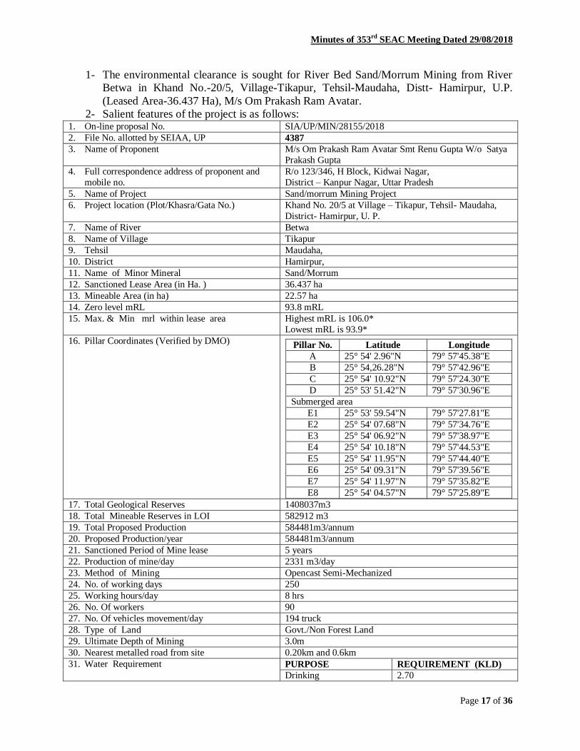
Minutes of 353rd
SEAC Meeting Dated 29/08/2018
Page 17 of 36
1- The environmental clearance is sought for River Bed Sand/Morrum Mining from River
Betwa in Khand No.-20/5, Village-Tikapur, Tehsil-Maudaha, Distt- Hamirpur, U.P.
(Leased Area-36.437 Ha), M/s Om Prakash Ram Avatar.
2- Salient features of the project is as follows: 1. On-line proposal No. SIA/UP/MIN/28155/2018
2. File No. allotted by SEIAA, UP 4387
3. Name of Proponent M/s Om Prakash Ram Avatar Smt Renu Gupta W/o Satya
Prakash Gupta
4. Full correspondence address of proponent and
mobile no.
R/o 123/346, H Block, Kidwai Nagar,
District – Kanpur Nagar, Uttar Pradesh
5. Name of Project Sand/morrum Mining Project
6. Project location (Plot/Khasra/Gata No.) Khand No. 20/5 at Village – Tikapur, Tehsil- Maudaha,
District- Hamirpur, U. P.
7. Name of River Betwa
8. Name of Village Tikapur
9. Tehsil Maudaha,
10. District Hamirpur,
11. Name of Minor Mineral Sand/Morrum
12. Sanctioned Lease Area (in Ha. ) 36.437 ha
13. Mineable Area (in ha) 22.57 ha
14. Zero level mRL 93.8 mRL
15. Max. & Min mrl within lease area Highest mRL is 106.0*
Lowest mRL is 93.9*
16. Pillar Coordinates (Verified by DMO)
Pillar No. Latitude Longitude
A 25° 54' 2.96"N 79° 57'45.38"E
B 25° 54,26.28"N 79° 57'42.96"E
C 25° 54' 10.92"N 79° 57'24.30"E
D 25° 53' 51.42"N 79° 57'30.96"E
Submerged area
E1 25° 53' 59.54"N 79° 57'27.81"E
E2 25° 54' 07.68"N 79° 57'34.76"E
E3 25° 54' 06.92"N 79° 57'38.97"E
E4 25° 54' 10.18"N 79° 57'44.53"E
E5 25° 54' 11.95"N 79° 57'44.40"E
E6 25° 54' 09.31"N 79° 57'39.56"E
E7 25° 54' 11.97"N 79° 57'35.82"E
E8 25° 54' 04.57"N 79° 57'25.89"E
17. Total Geological Reserves 1408037m3
18. Total Mineable Reserves in LOI 582912 m3
19. Total Proposed Production 584481m3/annum
20. Proposed Production/year 584481m3/annum
21. Sanctioned Period of Mine lease 5 years
22. Production of mine/day 2331 m3/day
23. Method of Mining Opencast Semi-Mechanized
24. No. of working days 250
25. Working hours/day 8 hrs
26. No. Of workers 90
27. No. Of vehicles movement/day 194 truck
28. Type of Land Govt./Non Forest Land
29. Ultimate Depth of Mining 3.0m
30. Nearest metalled road from site 0.20km and 0.6km
31. Water Requirement PURPOSE REQUIREMENT (KLD)
Drinking 2.70

Minutes of 353rd
SEAC Meeting Dated 29/08/2018
Page 18 of 36
Suppression of dust 4.00
Plantation 2.00
Others (if any) 0.00
Total 8.70
32. Name of QCI Accredited Consultant with
QCI No
period of validity.
Paramarsh (Servicing Environment and Development)
106
Oct. 31st 2018
33. Any litigation pending against the project or land
in any court
No
34. Details of 500 m Cluster Map & certificate
verified by Mining Officer
Letter No-476 dated 12.06.2018
35. Details of Lease Area in approved DSR Page No- 1 Table No- 97
36. Proposed CER cost 2.22 lacs
37. Proposed EMP cost ToR
38. Length and breadth of Haul Road 0.20km and 0.6km
3- The mining would be restricted to unsaturated zone only above the phreatic water table
and will not intersect the ground water table at any point of time.
4- This project does not attract any of the general conditions applicable on mining projects
specified in EIA Notification 14/09/2006.
5- The mining operation will not be carried out in safety zone of any bridge or embankment
or in eco-fragile zone such as habitat of any wild fauna.
6- There is no litigation pending in any court regarding this project.
7- The project proposal falls under category–1(a) of EIA Notification, 2006 (as amended).
Resolution against agenda no-9
The committee discussed the matter in light of MOEFCC Notification dated
15/01/2016 and recommended to issue the terms of reference (TOR) for the preparation of
EIA as annexed at annexure-1 to these minutes.
10. River Bed Sand/Morrum Mining from River Betwa in Khand No.- 24/17(Old Khand
No.- 24/16), Village- Chikasi, Tehsil- Sarila, Distt- Hamirpur, U.P., (Leased Area-36.437
Ha). File No. 4388/ Proposal No.SIA/UP/MIN/28156/2018
A presentation was made by the project proponent along with their consultant M/s
Paramarsh (Servicing Environment and Development). The proponent, through the documents
submitted and the presentation made, informed the committee that :-
1- The environmental clearance is sought for River Bed Sand/Morrum Mining from River
Betwa in Khand No.- 24/17 (Old Khand No.- 24/16), Village- Chikasi, Tehsil- Sarila,
Distt- Hamirpur, U.P., (Leased Area-36.437 Ha).
2- Salient features of the project is as follows: 1. On-line proposal No. SIA/UP/MIN/28156/2018
2. File No. allotted by SEIAA, UP 4388
3. Name of Proponent Sri Anand Kumar Gupta S/o Laxmi Narayan Gupta
4. Full correspondence address of proponent and mobile no.
R/o Maharajpur, Kanpur, District – Kanpur Nagar, Uttar Pradesh
5. Name of Project Sand/morrum Mining Project
6. Project location (Plot/Khasra/Gata No.) Khand No. 24/17 (Old Khand No. 24/16) at Village –

Minutes of 353rd
SEAC Meeting Dated 29/08/2018
Page 19 of 36
Chikasi, Tehsil- Sarila, District- Hamirpur, Uttar Pradesh
7. Name of River Betwa
8. Name of Village Chikasi
9. Tehsil Sarila
10. District Hamirpur,
11. Name of Minor Mineral Sand/Morrum
12. Sanctioned Lease Area (in Ha. ) 36.437 ha
13. Mineable Area (in Ha.) 29.52 ha
14. Zero level mRL 109.70 mRL*
15. Max. & Min mrl within lease area Highest mRL is 115.30mRL*
Lowest mRL is 109.70.0mRL*
16. Pillar Coordinates (Verified by DMO)
Pillar No. Latitude Longitude
A 25° 49' 09.54"N 79° 27'56.58"E
B 25° 49' 10.98"N 79° 27'29.64"E
C 25° 49' 30.90"N 79° 27'38.70"E
D 25° 49' 21.60"N 79° 27'59.88"E
17. Total Geological Reserves 15,91,173 m3
18. Total Mineable Reserves in LOI 7,28,640 m3 / annum
19. Total Proposed Production 7,28,640 m3/annum
20. Proposed Production/year 7,28,640 m3/annum
21. Sanctioned Period of Mine lease 5 years
22. Production of mine/day 2914 m3
23. Method of Mining Opencast Semi-Mechanized
24. No. of working days 250
25. Working hours/day 8 hrs
26. No. Of workers 90
27. No. Of vehicles movement/day 242 truck
28. Type of Land Govt./Non Forest Land
29. Ultimate Depth of Mining 3.0m
30. Nearest metalled road from site 0.90 km
31. Water Requirement PURPOSE REQUIREMENT (KLD)
Drinking 2.70
Suppression of dust 4.00
Plantation 2.00
Others (if any) 0.00
Total 8.70
32. Name of QCI Accredited Consultant with
QCI No
period of validity.
Paramarsh (Servicing Environment and Development)
106
Oct. 31st 2018
33. Any litigation pending against the project or land
in any court
No
34. Details of 500 m Cluster Map & certificate
verified by Mining Officer
Letter No-477 dated 12.06.2018
35. Details of Lease Area in approved DSR Page No- 10 Table No- 126
36. Proposed CSR cost 2.22 lacs
37. Proposed EMP cost ToR
38. Length and breadth of Haul Road 0.20km and 0.90km
3- The mining would be restricted to unsaturated zone only above the phreatic water table
and will not intersect the ground water table at any point of time.
4- This project does not attract any of the general conditions applicable on mining projects
specified in EIA Notification 14/09/2006.

Minutes of 353rd
SEAC Meeting Dated 29/08/2018
Page 20 of 36
5- The mining operation will not be carried out in safety zone of any bridge or embankment
or in eco-fragile zone such as habitat of any wild fauna.
6- There is no litigation pending in any court regarding this project.
7- The project proposal falls under category–1(a) of EIA Notification, 2006 (as amended).
Resolution against agenda no-10
The committee discussed the matter in light of MOEFCC Notification dated
15/01/2016 and recommended to issue the terms of reference (TOR) for the preparation of
EIA as annexed at annexure-1 to these minutes.
11. River Bed Sand/Morrum from River Betwa in Khand No.- 10/22 at Village- Beri,
Tehsil- & District- Hamirpur, U.P., (Leased Area-36.437 Ha). File No. 4390/ Proposal
No.SIA/UP/MIN/28157/2018
A presentation was made by the project proponent along with their consultant M/s
Paramarsh (Servicing Environment and Development). The proponent, through the documents
submitted and the presentation made, informed the committee that :-
1- The environmental clearance is sought for River Bed Sand/Morrum from River Betwa in
Khand No.- 10/22 at Village- Beri, Tehsil- & District- Hamirpur, U.P., (Leased Area-
36.437 Ha).
2- Salient features of the project is as follows:
1. On-line proposal No. SIA/UP/MIN/28157/2018
2. File No. allotted by SEIAA, UP 4390
3. Name of Proponent M/s Annapurna Udyog
Sri Mithlesh Kumar Gupta S/o Mahendra Kumar Gupta
4. Full correspondence address of proponent and
mobile no.
R/o 128/380, K Block, Kidwai Nagar, District – Kanpur
Nagar, Uttar Pradesh – 208011
5. Name of Project Sand/morrum Mining Project
6. Project location (Plot/Khasra/Gata No.) Khand No. 10/22 at Village – Beri,Tehsil- Hamirpur,
District- Hamirpur, U. P.
7. Name of River Betwa
8. Name of Village Beri
9. Tehsil Hamirpur
10. District Hamirpur UP
11. Name of Minor Mineral Sand/Morrum
12. Sanctioned Lease Area (in Ha. ) 36.437 ha
13. Mineable Area (in Ha.) 19.41 ha
14. Zero level mRL 94.4mRL*
15. Max. & Min mrl within lease area Highest mRL is 104.80
Lowest mRL is 94.4
16. Pillar Coordinates (Verified by DMO) Piller Latitude Longitude
A 25° 52' 44.66"N 79° 54' 10.71"E
B 25° 52' 57.20"N 79° 54' 18.59"E
C 25° 52' 48.93"N 79° 54' 31.95"E
D 25° 52' 22.83"N 79° 54' 24.45"E
Submerge Area
E1 25° 52' 46.04"N 79° 54' 11.66"E
E2 25° 52' 53.95"N 79° 54' 16.41”E
E3 25° 52' 42.42"N 79° 54' 16.45"E
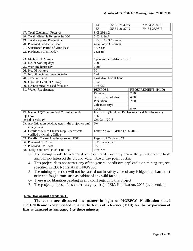
Minutes of 353rd
SEAC Meeting Dated 29/08/2018
Page 21 of 36
E4 25° 52' 29.40"N 79° 54' 26.82"E
E5 25° 52' 26.87"N 79° 54' 25.95"E
17. Total Geological Reserves 8,05,392 m3
18. Total Mineable Reserves in LOI 5,82,912m3
19. Total Proposed Production 4,84,143 m3 / annum
20. Proposed Production/year 4,84,143 m3 / annum
21. Sanctioned Period of Mine lease 5.0 Year
22. Production of mine/day 2331 m3
23. Method of Mining Opencast Semi-Mechanized
24. No. of working days 250
25. Working hours/day 8 hrs
26. No. Of workers 90
27. No. Of vehicles movement/day 194
28. Type of Land Govt./Non Forest Land
29. Ultimate Depth of Mining 3.0m
30. Nearest metalled road from site 0.65KM
31. Water Requirement PURPOSE REQUIREMENT (KLD)
Drinking 2.70
Suppression of dust 4.00
Plantation 2.00
Others (if any)
Total 8.70
32. Name of QCI Accredited Consultant with
QCI No
period of validity.
Paramarsh (Servicing Environment and Development)
106
Oct. 31st 2018
33. Any litigation pending against the project or land
in any court
No
34. Details of 500 m Cluster Map & certificate
verified by Mining Officer
Letter No-475 dated 12.06.2018
35. Details of Lease Area in approved DSR Page no. 1 Table no. 75
36. Proposed CER cost 2.22 Lac/annum
37. Proposed EMP cost ToR
38. Length and breadth of Haul Road 0.65 KM
3- The mining would be restricted to unsaturated zone only above the phreatic water table
and will not intersect the ground water table at any point of time.
4- This project does not attract any of the general conditions applicable on mining projects
specified in EIA Notification 14/09/2006.
5- The mining operation will not be carried out in safety zone of any bridge or embankment
or in eco-fragile zone such as habitat of any wild fauna.
6- There is no litigation pending in any court regarding this project.
7- The project proposal falls under category–1(a) of EIA Notification, 2006 (as amended).
Resolution against agenda no-11
The committee discussed the matter in light of MOEFCC Notification dated
15/01/2016 and recommended to issue the terms of reference (TOR) for the preparation of
EIA as annexed at annexure-1 to these minutes.

Minutes of 353rd
SEAC Meeting Dated 29/08/2018
Page 22 of 36
12. River Bed Sand/Morrum Mining from River Ken in Gata No.- 431, (Block No.-11) at
Village-Kanwara, Tehsil & District-Banda, U.P. (Lesaed Area-23.00 Ha). File No. 4391/
Proposal No.SIA/UP/MIN/28158/2018
A presentation was made by the project proponent along with their consultant M/s
Paramarsh (Servicing Environment and Development). The proponent, through the documents
submitted and the presentation made, informed the committee that :-
1- The environmental clearance is sought for River Bed Sand/Morrum Mining from River
Ken in Gata No.- 431, (Block No.-11) at Village-Kanwara, Tehsil & District-Banda, U.P.
(Lesaed Area-23.00 Ha).
2- Salient features of the project is as follows:
1. On-line proposal No. SIA/UP/MIN/28158/2018. 2. File No. allotted by SEIAA, UP 4391 3. Name of Proponent M/s Archisha Mines Pvt. Ltd.
Shri Arvind Singh S/o Late Shri Sabha Singh 4. Full correspondence address of proponent
and mobile no. R/o 1019, Naurang House 21, K G Marg, New Delhi
5. Name of Project Sand/morrum Mining Project 6. Project location (Plot/Khasra/Gata No.) Gata No. 431, (Block No. 11) at Village – Kanwara,
Tehsil- Banda, District- Banda 7. Name of River Ken 8. Name of Village Kanwara 9. Tehsil Banda 10. District Banda 11. Name of Minor Mineral Sand/Morrum 12. Sanctioned Lease Area (in Ha. ) 23.00 ha 13. Mineable Area (in Ha.) 18.37 ha 14. Zero level mRL 93.6mRL* 15. Max. & Min mrl within lease area Highest mRL is 103.80*
Lowest mRL is 94.5 * 16. Pillar Coordinates (Verified by DMO) Piller Latitude Longitude
A 25° 30' 54.06"N 80° 17' 24.20"E B 25° 30' 45.80"N 80° 17' 13.97"E C 25° 30' 35.34"N 80° 17' 30.18"E D 25° 30' 38.10"N 80° 17' 34.98"E E 25° 30' 41.04"N 80° 17' 35.64"E F 25° 30' 35.70"N 80° 17' 50.28"E G 25° 30' 37.67"N 80° 17' 48.45"E
17. Total Geological Reserves 8,19,973 m3 18. Total Mineable Reserves in LOI 4,60,000 m3/annum 19. Total Proposed Production 4,67,612 m3/annum 20. Proposed Production/year 4,67,612 m3 21. Sanctioned Period of Mine lease 5.0 Year 22. Production of mine/day 1840 m3 23. Method of Mining Opencast Semi-Mechanized
24. No. of working days 250 25. Working hours/day 8 hrs 26. No. Of workers 70 27. No. Of vehicles movement/day 153
Minutes of 353rd
SEAC Meeting Dated 29/08/2018
Page 23 of 36
28. Type of Land Govt./Non Forest Land 29. Ultimate Depth of Mining 3.0m 30. Nearest metalled road from site 0.55 KM 31. Water Requirement PURPOSE REQUIREMENT (KLD)
Drinking 2.70 Suppression of dust 3.00 Plantation 2.00 Others (if any) 0.00 Total 7.70
32. Name of QCI Accredited Consultant with QCI No period of validity.
Paramarsh (Servicing Environment and Development) 106 Oct. 31st 2018
33. Any litigation pending against the project or land in any court
No
34. Details of 500 m Cluster Map & certificate verified by Mining Officer
Letter No-1308 dated 11.06.2018
35. Details of Lease Area in approved DSR Page No. 2, Table no. 11 36. Proposed CER cost 1.15Lac/annum 37. Proposed EMP cost ToR 38. Length and breadth of Haul Road 0.55 KM
3- The mining would be restricted to unsaturated zone only above the phreatic water table
and will not intersect the ground water table at any point of time.
4- This project does not attract any of the general conditions applicable on mining projects
specified in EIA Notification 14/09/2006.
5- The mining operation will not be carried out in safety zone of any bridge or embankment
or in eco-fragile zone such as habitat of any wild fauna.
6- There is no litigation pending in any court regarding this project.
7- The project proposal falls under category–1(a) of EIA Notification, 2006 (as amended).
Resolution against agenda no-12
The committee discussed the matter in light of MOEFCC Notification dated
15/01/2016 and recommended to issue the terms of reference (TOR) for the preparation of
EIA as annexed at annexure-1 to these minutes.
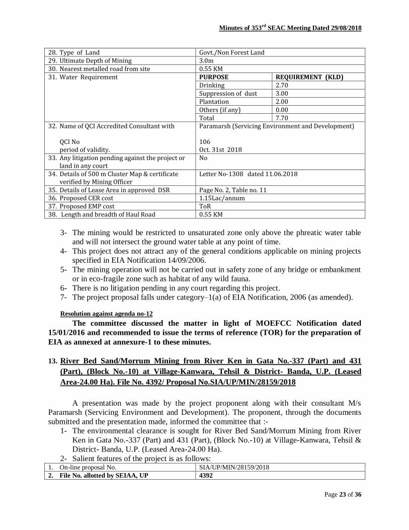
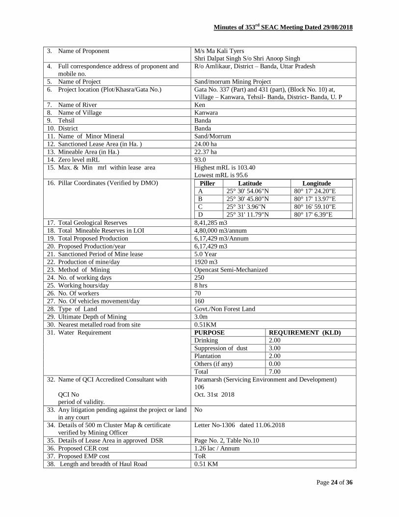
13. River Bed Sand/Morrum Mining from River Ken in Gata No.-337 (Part) and 431
(Part), (Block No.-10) at Village-Kanwara, Tehsil & District- Banda, U.P. (Leased
Area-24.00 Ha). File No. 4392/ Proposal No.SIA/UP/MIN/28159/2018
A presentation was made by the project proponent along with their consultant M/s
Paramarsh (Servicing Environment and Development). The proponent, through the documents
submitted and the presentation made, informed the committee that :-
1- The environmental clearance is sought for River Bed Sand/Morrum Mining from River
Ken in Gata No.-337 (Part) and 431 (Part), (Block No.-10) at Village-Kanwara, Tehsil &
District- Banda, U.P. (Leased Area-24.00 Ha).
2- Salient features of the project is as follows: 1. On-line proposal No. SIA/UP/MIN/28159/2018
2. File No. allotted by SEIAA, UP 4392
Minutes of 353rd
SEAC Meeting Dated 29/08/2018
Page 24 of 36
3. Name of Proponent M/s Ma Kali Tyers
Shri Dalpat Singh S/o Shri Anoop Singh
4. Full correspondence address of proponent and
mobile no.
R/o Amlikaur, District – Banda, Uttar Pradesh
5. Name of Project Sand/morrum Mining Project
6. Project location (Plot/Khasra/Gata No.) Gata No. 337 (Part) and 431 (part), (Block No. 10) at,
Village – Kanwara, Tehsil- Banda, District- Banda, U. P
7. Name of River Ken
8. Name of Village Kanwara
9. Tehsil Banda
10. District Banda
11. Name of Minor Mineral Sand/Morrum
12. Sanctioned Lease Area (in Ha. ) 24.00 ha
13. Mineable Area (in Ha.) 22.37 ha
14. Zero level mRL 93.0
15. Max. & Min mrl within lease area Highest mRL is 103.40
Lowest mRL is 95.6
16. Pillar Coordinates (Verified by DMO) Piller Latitude Longitude
A 25° 30' 54.06"N 80° 17' 24.20"E
B 25° 30' 45.80"N 80° 17' 13.97"E
C 25° 31' 3.96"N 80° 16' 59.10"E
D 25° 31' 11.79"N 80° 17' 6.39"E
17. Total Geological Reserves 8,41,285 m3
18. Total Mineable Reserves in LOI 4,80,000 m3/annum
19. Total Proposed Production 6,17,429 m3/Annum
20. Proposed Production/year 6,17,429 m3
21. Sanctioned Period of Mine lease 5.0 Year
22. Production of mine/day 1920 m3
23. Method of Mining Opencast Semi-Mechanized
24. No. of working days 250
25. Working hours/day 8 hrs
26. No. Of workers 70
27. No. Of vehicles movement/day 160
28. Type of Land Govt./Non Forest Land
29. Ultimate Depth of Mining 3.0m
30. Nearest metalled road from site 0.51KM
31. Water Requirement PURPOSE REQUIREMENT (KLD)
Drinking 2.00
Suppression of dust 3.00
Plantation 2.00
Others (if any) 0.00
Total 7.00
32. Name of QCI Accredited Consultant with
QCI No period of validity.
Paramarsh (Servicing Environment and Development)
106
Oct. 31st 2018
33. Any litigation pending against the project or land
in any court
No
34. Details of 500 m Cluster Map & certificate
verified by Mining Officer
Letter No-1306 dated 11.06.2018
35. Details of Lease Area in approved DSR Page No. 2, Table No.10
36. Proposed CER cost 1.26 lac / Annum
37. Proposed EMP cost ToR
38. Length and breadth of Haul Road 0.51 KM
Minutes of 353rd
SEAC Meeting Dated 29/08/2018
Page 25 of 36
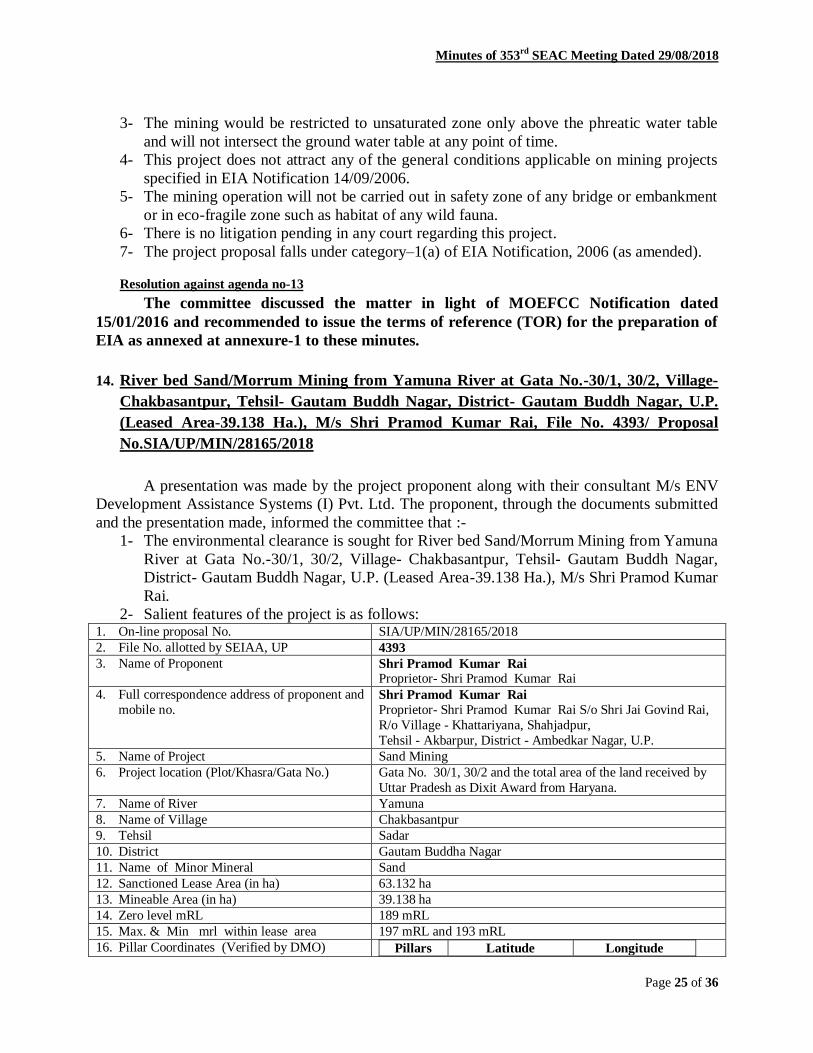
3- The mining would be restricted to unsaturated zone only above the phreatic water table
and will not intersect the ground water table at any point of time.
4- This project does not attract any of the general conditions applicable on mining projects
specified in EIA Notification 14/09/2006.
5- The mining operation will not be carried out in safety zone of any bridge or embankment
or in eco-fragile zone such as habitat of any wild fauna.
6- There is no litigation pending in any court regarding this project.
7- The project proposal falls under category–1(a) of EIA Notification, 2006 (as amended).
Resolution against agenda no-13
The committee discussed the matter in light of MOEFCC Notification dated
15/01/2016 and recommended to issue the terms of reference (TOR) for the preparation of
EIA as annexed at annexure-1 to these minutes.
14. River bed Sand/Morrum Mining from Yamuna River at Gata No.-30/1, 30/2, Village-
Chakbasantpur, Tehsil- Gautam Buddh Nagar, District- Gautam Buddh Nagar, U.P.
(Leased Area-39.138 Ha.), M/s Shri Pramod Kumar Rai, File No. 4393/ Proposal
No.SIA/UP/MIN/28165/2018
A presentation was made by the project proponent along with their consultant M/s ENV
Development Assistance Systems (I) Pvt. Ltd. The proponent, through the documents submitted
and the presentation made, informed the committee that :-
1- The environmental clearance is sought for River bed Sand/Morrum Mining from Yamuna
River at Gata No.-30/1, 30/2, Village- Chakbasantpur, Tehsil- Gautam Buddh Nagar,
District- Gautam Buddh Nagar, U.P. (Leased Area-39.138 Ha.), M/s Shri Pramod Kumar
Rai.
2- Salient features of the project is as follows: 1. On-line proposal No. SIA/UP/MIN/28165/2018
2. File No. allotted by SEIAA, UP 4393
3. Name of Proponent Shri Pramod Kumar Rai Proprietor- Shri Pramod Kumar Rai
4. Full correspondence address of proponent and
mobile no. Shri Pramod Kumar Rai
Proprietor- Shri Pramod Kumar Rai S/o Shri Jai Govind Rai,
R/o Village - Khattariyana, Shahjadpur,
Tehsil - Akbarpur, District - Ambedkar Nagar, U.P.
5. Name of Project Sand Mining
6. Project location (Plot/Khasra/Gata No.) Gata No. 30/1, 30/2 and the total area of the land received by
Uttar Pradesh as Dixit Award from Haryana.
7. Name of River Yamuna
8. Name of Village Chakbasantpur
9. Tehsil Sadar
10. District Gautam Buddha Nagar
11. Name of Minor Mineral Sand
12. Sanctioned Lease Area (in ha) 63.132 ha
13. Mineable Area (in ha) 39.138 ha
14. Zero level mRL 189 mRL
15. Max. & Min mrl within lease area 197 mRL and 193 mRL
16. Pillar Coordinates (Verified by DMO) Pillars Latitude Longitude

Minutes of 353rd
SEAC Meeting Dated 29/08/2018
Page 26 of 36
Sanctioned Lease Area
A 28°30'1.66"N 77°21'24.32"E
B 28°29'58.64"N 77°21'17.44"E
C 28°30'0.13"N 77°21'10.52"E
D 28°30'2.07"N 77°21'1.70"E
E 28°30'19.80"N 77°20'49.34"E
F 28°30'34.92"N 77°20'50.44"E
G 28°30'47.07"N 77°20'40.99"E
H 28°30'51.38"N 77°20'48.34"E
I 28°30'39.29"N 77°20'56.37"E
J 28°30'27.62"N 77°21'4.15"E
K 28°30'16.70"N 77°21'11.40"E
L 28°30'7.14"N 77°21'17.77"E
Workable Area
B1 28°29'59.37"N 77°21'13.95"E
C 28°30'0.13"N 77°21'10.52"E
D 28°30'2.07"N 77°21'1.70"E
E 28°30'19.80"N 77°20'49.34"E
E1 28°30'30.12"N 77°20'50.09"E
L 28°30'7.14"N 77°21'17.77"E
L1 28°30'2.57"N 77°21'23.25"E
Restricted Lease Area due to Yamuna Marginal
Bund
E1 28°30'30.12"N 77°20'50.09"E
F 28°30'34.92"N 77°20'50.44"E
G 28°30'47.07"N 77°20'40.99"E
H 28°30'51.38"N 77°20'48.34"E
I 28°30'39.29"N 77°20'56.37"E
J 28°30'27.62"N 77°21'4.15"E
K 28°30'16.70"N 77°21'11.40"E
L 28°30'7.14"N 77°21'17.77"E
Restricted Lease Area due to Air Force Land
L1 28°30'2.57"N 28°30'2.57"N
A 28°30'1.66"N 77°21'24.32"E
B 28°29'58.64"N 77°21'17.44"E
B1 28°29'59.37"N 77°21'13.95"E
17. Total Geological Reserves 19,56,900 m3
18. Total Mineable Reserves in LOI 4,41,924 m3/year
19. Total Proposed Production as per Form-1,
PFR, Mine Plan and presentation at SEAC
4,41,924 m3/year (22,09,620 m3 in 05 years)
20. Proposed Production/year 4,41,924 m3
21. Sanctioned Period of Mine lease 5 years
22. Production of mine/day 1607 m3/day
23. Method of Mining Opencast Semi-mechanized Method
24. No. of working days 275 days
25. Working hours/day 12 hours
26. No. Of workers Approximately 52 labours
27. No. Of vehicles movement/day 107units
28. Type of Land Government Waste Land (Revenue land)
29. Ultimate Depth of Mining 3 m
30. Nearest metalled road from site MDR (Jaitpur Pushta Road): 0.7 km*(W)
31. Water Requirement PURPOSE REQUIREMENT (KLD)
Drinking 0.52
Minutes of 353rd
SEAC Meeting Dated 29/08/2018
Page 27 of 36
Suppression of dust 9.6
Plantation 0.08
Others (if any) -
Total 10.20 KLD
32. Name of QCI Accredited Consultant with
QCI No and period of validity.
ENV Development Assistance Systems (I) Pvt. Ltd.
NABET/EIA/1720/RA 0078 and Valid till 02/04/2020.
33. Any litigation pending against the project or
land in any court
None
34. Details of 500 m Cluster Map & certificate
verified by Mining Officer
Letter No. 1744/ [k0vuq0/xkSrecq) uxj /2018 fnukad %
28/08/2018
35. Details of Lease Area in approved DSR Page No 21; Table No.11
36. Proposed CSR cost 5% of total project cost i.e. Rs. 7,35,000/-
37. Proposed EMP cost & Total Project Cost Rs. 42,40,220/- & Rs. 1,47,07,000/-
38. Length and Width of Haul Road 800 m Length and 6 m width
39. No. of Trees to be Planted 316
3- The mining would be restricted to unsaturated zone only above the phreatic water table
and will not intersect the ground water table at any point of time.
4- This project does not attract any of the general conditions applicable on mining projects
specified in EIA Notification 14/09/2006.
5- The mining operation will not be carried out in safety zone of any bridge or embankment
or in eco-fragile zone such as habitat of any wild fauna.
6- There is no litigation pending in any court regarding this project.
7- The project proposal falls under category–1(a) of EIA Notification, 2006 (as amended).
Resolution against agenda no-14
The committee discussed the matter in light of MOEFCC Notification dated
15/01/2016 and recommended to issue the terms of reference (TOR) for the preparation of
EIA as annexed at annexure-1 to these minutes.
15. River Bed Sand/Morrum Mining at Bank of Betwa River at Khand No.- 23/23, Village-
Bhedi Kharka, Tehsil- Sarila, District- Hamirpur, U.P., over an area 12.145 ha (Total
cluster area - 121.454 Ha). File No. 4396/ Proposal No.SIA/UP/MIN/28243/2018
A presentation was made by the project proponent along with their consultant M/s
Cognizance Research India Pvt. Ltd. The proponent, through the documents submitted and the
presentation made, informed the committee that :-
1- The environmental clearance is sought for River Bed Sand/Morrum Mining at Bank of
Betwa River at Khand No.- 23/23, Village-Bhedi Kharka, Tehsil-Sarila, District-
Hamirpur, U.P., over an area 12.145 ha (Total cluster area - 121.454 Ha).
2- Salient features of the project is as follows: 1. On-line proposal No. SIA/UP/MIN/28243/2018
2. File No. allotted by SEIAA, UP 4396
3. Name of Proponent M/s Radhika Crusher Mines & Stone
4. Full correspondence address of proponent and
mobile no.
2A Kusum Apartment Asoka Garden
Bhopal (M.P.)
5. Name of Project Bhedi Kharka Sand/Moram Mining project
6. Project location (Plot/Khasra/Gata No.) Khand no.- 23/23
7. Name of River Betwa River
Minutes of 353rd
SEAC Meeting Dated 29/08/2018
Page 28 of 36
8. Name of Village Bhedi Kharka
9. Tehsil Sarila
10. District District Hamirpur, Uttar Pradesh
11. Name of Minor Mineral Sand/Morrum Mining
12. Sanctioned Lease Area (in Ha. ) 12.145 ha.
13. Mineable Area (in Ha. ) 6.70 Ha
14. Zero level mRL 99 mRL
15. Max. & Min mrl within lease area 105 mRL & 99.0mRL
16. Pillar Coordinates (Verified by DMO) Coordinates of total lease area:
A 25o 54‟30.31”N; 79o 49‟26.21”E
B 25o 54‟30.97”N; 79o 49‟35.75”E
C 25o 54‟20.87”N; 79o 49‟40.01”E
D 25o 54‟20.57”N; 79o 49‟21.01”E
Coordinates of workable area: B 25o 54‟30.97”N; 79o 49‟35.75”E
D 25o 54‟20.57”N; 79o 49‟21.01”E
E 25°54'30.51"N; 79°49'28.12"E
F 25°54'20.45"N; 79°49'33.56“ E
Coordinates of submerged area:
A 25o 54‟30.31”N; 79o 49‟26.21”E
C 25o 54‟20.87”N; 79o 49‟40.01”E
E 25°54'30.51"N; 79°49'28.12“ E
F 25°54'20.45"N; 79°49'33.56“ E
17. Total Geological Reserves 203714 m3
18. Total Mineable Reserves in LOI 194304 m3 /Year
19. Total Proposed Production (in five year) 971520 m3 or 1748736 tone
20. Proposed Production/year 194304 m3 /Year 349747.2 TPA
21. Sanctioned Period of Mine lease 07-06-2018
22. Production of mine/day 1399 TPD
23. Method of Mining Opencast Semi-Mechanized/Mechanized
24. No. of working days 250
25. Working hours/day 8
26. No. Of workers 53
27. No. Of vehicles movement/day 70
28. Type of Land Govt Land
29. Ultimate Depth of Mining maximum 3 m
30. Nearest metalled road from site SH-91
31. Water Requirement PURPOSE REQUIREMENT (KLD)
Drinking 0.6 KLD
Suppression of dust 5.5 KLD
Plantation 3.0 KLD
Others (if any)
Total 9.1 kld
32. Name of QCI Accredited Consultant with QCI No and period of validity.
Cognizance Research India Pvt Ltd. 1619, validity=31-01-2019
33. Any litigation pending against the project or land in
any court
No
34. Details of 500 m Cluster Map & certificate issued
by Mining Officer
Letter No. 528/khaniz- M.M.C-30-vividh (2018-19)
dated. 27-06-2018
35. Details of Lease Area in approved DSR Table no. 20, Page No.64
36. Proposed CSR cost RS-1,00,000/-
37. Proposed EMP cost Capital Rs-4,00,000/- recurring cost- Rs 7,00,000/-
Minutes of 353rd
SEAC Meeting Dated 29/08/2018
Page 29 of 36
38. Length and breadth of Haul Road 920m, 6 m
39. No. of Trees to be Planted 1850 plants
3- The mining would be restricted to unsaturated zone only above the phreatic water table
and will not intersect the ground water table at any point of time.
4- This project does not attract any of the general conditions applicable on mining projects
specified in EIA Notification 14/09/2006.
5- The mining operation will not be carried out in safety zone of any bridge or embankment
or in eco-fragile zone such as habitat of any wild fauna.
6- There is no litigation pending in any court regarding this project.
7- The project proposal falls under category–1(a) of EIA Notification, 2006 (as amended).
Resolution against agenda no-15
The committee discussed the matter in light of MOEFCC Notification dated
15/01/2016 and recommended to issue the terms of reference (TOR) for the preparation of
EIA as annexed at annexure-1 to these minutes.
16. River Bed Sand/Morrum Mining at Bank of Betwa River at Khand No.- 23/21, Village-
Bhedi Kharka, Tehsil-Sarila, District-Hamirpur, U.P. (Leased Area-24.291 Ha). File
No. 4397/ Proposal No.SIA/UP/MIN/28245/2018
A presentation was made by the project proponent along with their consultant M/s
Cognizance Research India Pvt. Ltd. The proponent, through the documents submitted and the
presentation made, informed the committee that :-
1- The environmental clearance is sought for river bed Sand/Morrum Mining at Bank of
Betwa River at Khand No.- 23/21, Village-Bhedi Kharka, Tehsil-Sarila, District-
Hamirpur, U.P. (Leased Area-24.291 Ha).
2- Salient features of the project is as follows: 1. On-line proposal No. SIA/UP/MIN/28245/2018
2. File No. allotted by SEIAA, UP 4397
3. Name of Proponent M/s Alpine Resource LLP
4. Full correspondence address of proponent and
mobile no.
A-7 Basant Bihar, Gwalior
Madhya Pradesh.
5. Name of Project Bhedi Kharka Sand/Moram Mining project
6. Project location (Plot/Khasra/Gata No.) Khand no.- 23/21
7. Name of River Betwa River
8. Name of Village Bhedi Kharka
9. Tehsil Sarila
10. District District Hamirpur, Uttar Pradesh
11. Name of Minor Mineral Sand/Morrum Mining
12. Sanctioned Lease Area (in Ha. ) 24.291 ha.
13. Mineable Area (in Ha. ) 13.42 Ha
14. Zero level mRL 99 mRL
15. Max. & Min mrl within lease area 109 mRL & 99.0mRL
16. Pillar Coordinates (Verified by DMO) Coordinates of total lease Area:
A 25o 54‟20.52”N; 79o 49‟21.00”E
B 25o 54‟8.38”N; 79o 49‟16.56”E
C 25o 54‟09.03”N; 79o 49‟44.53”E D 25
o 54‟20.86”N; 79
o 49‟40.02”E
coordinates of workable area :
A 25o 54‟20.52”N; 79o 49‟21.00”E
B 25o 54‟8.38”N; 79o 49‟16.56” E

Minutes of 353rd
SEAC Meeting Dated 29/08/2018
Page 30 of 36
A‟ 25°54'20.20"N 79°49'33.73"E
B‟ 25°54'8.46"N 79°49'38.50"E
3)Coordinates of Submerged Area:
A‟ 25°54'20.20"N 79°49'33.73"E
B‟ 25°54'8.46"N 79°49'38.50"E
C 25o 54‟09.03”N; 79o 49‟44.53”E D 25o 54‟20.86”N; 79o49‟40.02”E
17. Total Geological Reserves 552855 m3
18. Total Mineable Reserves in LOI 3, 88,608 m3 /Year
19. Total Proposed Production (in five year) 1943040 m3 or 3497472 tone
20. Proposed Production/year 3, 88,608 m3 /Year 6, 99,494.4 TPA
21. Sanctioned Period of Mine lease 07-06-2018
22. Production of mine/day 2798 TPD
23. Method of Mining Opencast Semi-Mechanized/Mechanized
24. No. of working days 250
25. Working hours/day 8
26. No. Of workers 65
27. No. Of vehicles movement/day 140
28. Type of Land Govt Land
29. Ultimate Depth of Mining maximum 3 m
30. Nearest metalled road from site SH-91
31. Water Requirement PURPOSE REQUIREMENT (KLD)
Drinking 0.7 KLD
Suppression of dust 3.7 KLD
Plantation 2.0 KLD
Others (if any)
Total 6.4 kld
32. Name of QCI Accredited Consultant with QCI No
and period of validity.
Cognizance Research India Pvt Ltd.
1619, validity=31-01-2019
33. Any litigation pending against the project or land
in any court
No
34. Details of 500 m Cluster Map & certificate issued
by Mining Officer
Letter No. 529/khaniz- M.M.C-30-vividh (2018-19) dated.
27-06-2018
35. Details of Lease Area in approved DSR Table no. 20, Page No.64
36. Proposed CSR cost RS-1,20,000/-
37. Proposed EMP cost Capital Rs-4,80,000/- recurring cost- Rs 7,20,000/-
38. Length and breadth of Haul Road 620 m, 6 m
39. No. of Trees to be Planted 1250 plants
3- The mining would be restricted to unsaturated zone only above the phreatic water table
and will not intersect the ground water table at any point of time.
4- This project does not attract any of the general conditions applicable on mining projects
specified in EIA Notification 14/09/2006.
5- The mining operation will not be carried out in safety zone of any bridge or embankment
or in eco-fragile zone such as habitat of any wild fauna.
6- There is no litigation pending in any court regarding this project.
7- The project proposal falls under category–1(a) of EIA Notification, 2006 (as amended).
Resolution against agenda no-16
The committee discussed the matter in light of MOEFCC Notification dated
15/01/2016 and recommended to issue the terms of reference (TOR) for the preparation of
EIA as annexed at annexure-1 to these minutes.

Minutes of 353rd
SEAC Meeting Dated 29/08/2018
Page 31 of 36
17. River bed Sand/Morrum Mining from Betwa River at Khand No.- 01, Gata No.- 2513,
2629, Village-Kharka, Tehsil- Orai, District-Jalaun, U.P., (Leased Area-20.242 Ha.)
File No. 4403/ Proposal No.SIA/UP/MIN/ 28354/2018
A presentation was made by the project proponent along with their consultant M/s
Globus Environment Engineering Service. The proponent, through the documents submitted and
the presentation made, informed the committee that :-
1- The environmental clearance is sought for River bed Sand/Morrum mining from Betwa
River at Khand No.- 01, Gata No.- 2513, 2629, Village-Kharka, Tehsil- Orai, District-
Jalaun, U.P., (Leased Area-20.242 Ha.).
2- Salient features of the project is as follows: 1. On-line proposal No. SIA/UP/MIN/28354/2018, Dated- 21.07.2018
2.File no. allotted by SEIAA,UP F.No.- 4403, Dated- 25.07.2018
3. Name of Proponent Shri. Ram Kumar Singh
(Owner)
4. Full correspondence address of proponent
and mobile no.
R/O- Range Chauraha, Gursarai, Thana- Gursarai,Tehsil- Garautha,
District- Jhansi (U.P)
5. Name of Project “Sand/ Morum Mining”
6. Project location (Plot/Khasra/Gate No.) Khand No.1, Gata No. 2513, 2629
7. Name of River Betwa River
8. Name of Village Kharka
9. Tehsil Orai
10. District Jalaun
11. Name of Minor Mineral River Bed Material (Sand/Morum)
12. Sanctioned Lease Area (in Ha.) 20.242 Ha
13. Mineable Area (in Ha.) 11.40Ha
14. Zero level mRL 98mRL
15. Max. & Min mrl within lease area Highest: 101.50mRL & Lowest: 98.0mRL
16. Pillar Coordinates (Verified by DMO) Sanctioned Area
Pillars Latitude Longitude
A 25°53'15.56"N 79°34'8.01"E
B 25°53'12.90"N 79°34'7.92"E
C 25°53'9.55"N 79°34'5.70"E
D 25°53'7.90"N 79°34'4.60"E
E 25°53'6.23"N 79°34'10.11"E
F 25°53'9.82"N 79°34'31.42"E
G 25°53'12.61"N 79°34'31.22"E
H 25°53'20.08"N 79°34'30.68"E
Workable Area
Pillars Latitude Longitude
A 25°53'15.56"N 79°34'8.01"E
B 25°53'12.90"N 79°34'7.92"E
C 25°53'9.55"N 79°34'5.70"E
G 25°53'12.61"N 79°34'31.22"E
H 25°53'20.08"N 79°34'30.68"E
Submerged Area
Pillars Latitude Longitude
C 25°53'9.55"N 79°34'5.70"E
D 25°53'7.90"N 79°34'4.60"E
E 25°53'6.23"N 79°34'10.11"E
F 25°53'9.82"N 79°34'31.42"E
G 25°53'12.61"N 79°34'31.22"E

Minutes of 353rd
SEAC Meeting Dated 29/08/2018
Page 32 of 36
17. Total Geological Reserves 3,83,740 m3
18. Total Mineable Reserves in LOI 2,12,984 m3/ annum
19. Total Proposed Production (in five year) 10,12,100m3
20. Proposed Production/year 2,02,420 m3/ annum
21. Sanctioned Period of Mine lease 5 Years
22. Production of mine/day 810m3/day (1458 tonnes)
23. Method of Mining Opencast Semi-mechanized Method
24. No. of Working days 250 Days
25. Working hours/day 12 hours/day
26. No. Of Workers 65 Manpower
27. No. Of vehicles movement/day 146 Units
(Assumed Loading Capacity: 10 Tonnes/Unit)
28. Type of Land State Government Land
29. Ultimate Depth of Mining 2.0m
30. Nearest metalled road from site Dadri Link Road is 3.5 km, North
31. Water Requirement
Source Purpose Avg. Demand/ Day
Portable
Tanker
Drinking
@15 lpcd/worker
1.0 KLD
Surface
Water
Land reclamation/plantation
@5 Lit/Tree
0.5 KLD
Dust suppression
@2 Lit/Sq.m
(Haulage Road Area = 3500mLength x 6mWidth)
42.0 KLD
Total 43.5 KLD
32. Name of QCI Accredited Consultant
with QCI No and period of validity.
GLOBUS ENVIRONMENT ENGINEERING SERVICES
Certificate No. NABET/EIA/1821/IA0034, Valid Till April 03/2021
33. Any litigation pending against the
project or hand in any court
No
34. Details of 500 m Cluster Map &
certificate issued by Mining Officer
NA
35. Details of Lease Area in approved DSR Page No.53, Table No.16, Sr. No. 8
36. Proposed CER cost Rs. 3.27 Lakhs per annum
37. Proposed EMP cost Rs. 27 Lakhs
38. Length and Width of Haul Road Haulage Road Length 3500m & Haul Road Width 6 m
39. No. of Trees to be Planted 100 Trees per Year
3- The mining would be restricted to unsaturated zone only above the phreatic water table
and will not intersect the ground water table at any point of time.
4- This project does not attract any of the general conditions applicable on mining projects
specified in EIA Notification 14/09/2006.
5- The mining operation will not be carried out in safety zone of any bridge or embankment
or in eco-fragile zone such as habitat of any wild fauna.
6- There is no litigation pending in any court regarding this project.
7- The project proposal falls under category–1(a) of EIA Notification, 2006 (as amended).
Resolution against agenda no-17
The committee discussed the matter in light of MOEFCC Notification dated
15/01/2016 and recommended to issue the terms of reference (TOR) for the preparation of
EIA as annexed at annexure-1 to these minutes.

Minutes of 353rd
SEAC Meeting Dated 29/08/2018
Page 33 of 36
Matter with the permission of Chairman:
18. ek0 ,u-th-Vh- esa fopkjk/khu vihy la[;k&53@2018 ds lEcU/k esa lfefr }kjk fopkj&foe'kZA
The committee noted that as per the direction of SEIAA, the matter was listed in SEAC
meeting dated 20/08/2018 wherein the committee informed about the approval of the draft
affidavit in the above mentioned matter prepared by the Standing Council, Shri Ankit Verma and
posted by Regional Office, Noida on dated 12/07/2018. The affidavit has already been submitted
in Hon‟ble National Green Tribunal on dated 23/07/2018. The copy of the same is available in
the respective file. If any other action desired by SEIAA, it must be clearly illustrated.
Further, the Secretariat has informed about the E-mail subjected as rejoinders in the
matter appeal no. 53 of 2018 Naresh Kumar Vs. MoEFCC and ors posted by Directorate of
Environment, Regional Office, Noida dated 23/08/2018 enclosing rejoinders in the matter appeal
no. 53 of 2018 Naresh Kumar Vs. MoEFCC and Ors as communicated by Shri Ankit Verma,
Standing Council to provided necessary instruction in the matter approved by concerned
respondents i.e. SEIAA and SEAC respondent no. 3 & 4 respectively.
The committee has gone through the rejoinders reply dated 07/08/2018 filed by the
applicant Naresh Kumar. The committee noted the factual status regarding the reply and is of
view to take action in accordance to power delegated by Ministry of Environment & Forest,
Govt. of India issued vide Notification No. S.O. 637(E) dated 28/02/2014 to the project
proponent Shri Akshit Sharma, Partner, House no. 74, C.O.D. Farm, Jwala Nagar, Vikas Nagar,
Tehsil-Sadar, District-Rampur, U.P.-244901 for non compliance of the conditions laid in the
Environment Clearance letter no. 224/Parya/SEAC/4035/2018 dated 08/03/2018.
Matter with the permission of Chairman:
The committee has approved format of cluster certificate to be issued by competent
authority as per EIA Notification (as amended) vide S.O. 3977(E), dated 14/08/2018.
(Dr. Sarita Sinha)
Member
(Dr. Virendra Mishra)
Member
(Dr. Pramod Kumar Mishra)
Member
(Dr. Richpal Singh Sangu)
Member
(Dr. Ranjeet Kumar Dalela)
Member
(Dr. Ajoy Kumar Mandal)
Member
(Shri Meraj Uddin)
Member
(Dr. (Prof.) S. N. Singh)
Chairman

Minutes of 353rd
SEAC Meeting Dated 29/08/2018
Page 34 of 36
Annexure-1
Terms of Reference for Mining Project
1. The TOR shall be valid strictly for the annual production/yearly production as given in the
approved Mining Plans of the respective proposal.
2. Regional combined EMP study should be carried out.
3. Regional combined area of homogeneous leases in cluster situation should be verified by DMO.
4. Certificate from Mining Officer that there is no other mining area exit within 500 m periphery.
5. CER cost to be calculated for individual lease.
6. An intimation regarding conducting the monitoring to be sent to concerned District Magistrate
and State Pollution Control Board office.
7. The lab conducting the analysis should be authenticated and registered.
8. Public hearing to be conducted as per EIA Notification, 2006.
9. A copy of document in support of fact that the proponent is the rightful lessee of the mine should
be given.
10. Approved mining plans for all the mining projects.
11. All documents including approved mine plan, EIA and public hearing should be compatible with
one another in terms of the mine lease area, production level, waste generation and its
management and mining technology and should be in the name of the lessee. The mine plan
should take into account the conditions of the mine lease, if any, in terms of distance to be left
un-worked from the river flowing nearby.
12. The study area will comprise of 10 km zone around the mine lease from the lease periphery and
the data contained in the EIA such as waste generation etc should be for the life of the mine /
lease period.
13. Land use of the study area delineating forest area, agricultural land, grazing land, wildlife
sanctuary and national park, migratory route of fauna, water bodies, human settlements and
other ecological features should be indicated.
14. Land use plan of mine lease area should be prepared to encompass pre-operational, operational
and post-operational phases and submitted.
15. Location of National Parks, Sanctuaries, Biosphere Reserves, wildlife Corridors, Tiger/Elephant
Reserves (existing as well as proposed), if any, within 10 km of the mine lease should be clearly
indicated supported by a location map duly authenticated by Chief Wildlife Warden. Necessary
clearance, if any, as may be applicable to such projects due to proximity of the ecologically
sensitive areas as mentioned above should be obtained from the state Wildlife Department /
Chief Wildlife Warden under the Wildlife (Protection) Act, 1972 and copy furnished.
16. A detailed biological study for the study area [core zone and buffer zone (10 km radius of the
periphery of the mine lease)] shall be carried out covering both terrestrial and aquatic flora and
fauna. Details of flora and fauna, duly authenticated, separately for core and buffer zone should
be furnished based on field survey clearly indicating the Schedule of the fauna present.
17. Impact of change of land use should be given.
18. Impact of mining on the hydrology of the area including water flow in the river adjoining the
mine lease. It should also take into account the inundation of mined out area due to flow of water
from the river.
19. R & R plan / compensation details for the project affected people should be furnished. While
preparing the R & R plan, the National Rehabilitation & Resettlement Policy should be kept in
view. In respect of SCs / STs and other weaker sections need based sample survey, family-wise,
should be undertaken to assess their requirement and action programmes prepared accordingly
integrating the sectoralprogramme of line departments of the State Governments.
20. 02 km kachcha haul road to be made motorable. Submit Plan.
Minutes of 353rd
SEAC Meeting Dated 29/08/2018
Page 35 of 36
21. One season (Non Monsoon) primary baseline data on ambient air quality (PM2.5, PM10, SOx
and NOx), water quality, noise level, soil and flora and fauna shall be collected and the AAQ
data so collected presented data-wise in the EIA and EMP report. Site-specific meteorological
data should also be collected. The location of the monitoring stations should be justified.
22. There should be at least one monitoring station within 500 m of the mine lease in the pre-
dominant downwind direction. The mineralogical composition of PM10 particularly for free
silica should be given.
23. Air quality modeling should be carried out for prediction of impact of the project on the air
quality of the area. It should also take into account the impact of movement of vehicle for
transportation of mineral. The details of the model used and input parameters used for modeling
should be provided. The air quality contours may be may be shown on a location map clearly
indicating the location of the site, location of sensitive receptors, if any and the habitation. The
wind rose showing pre-dominant wind direction may also be indicated on the map. The impact
of stone crusher nearby should also be taken into account.
24. The water requirement for the project, its availability and source to be furnished. A detailed water
balance should also be provided. Fresh water requirement for the project should be indicated.
25. Necessary clearance from the Competent Authority for drawl of requisite quantity of water for the
project should be provided.
26. Details of water conservation measures proposed to be adopted in the projected should be given.
27. Impact of the project on the water quality both surface and groundwater should be assessed and
necessary safeguard measures, if any required should be provided.
28. Based on actual monitored data, it may clearly be shown whether working will intersect
groundwater. Necessary data and documentation in this regard may be provided. In case the
working will intersect groundwater table, a detailed hydro geological study should be undertaken
and report furnished. Necessary permission from Central Ground Water Authority for working
below ground water and for pumping of groundwater should also be obtained and copy
furnished.
29. Details of first order stream, if any passing through lease area and modification diversion
proposed, if any and the impact of the same on the hydrology should be brought out.
30. Details of rainwater harvesting proposed, if any, in the project should be provided.
31. Information on reduced levels site elevation, working depth, groundwater table etc. below natural
surface level should be provided. A schematic diagram may also be provided for the same.
32. Quantity of solid waste generated to be estimated and details for its disposal and management
should be provided. The quality, volumes and methodology planned for removal and utilization
(preferably concurrently) of top soil should be indicated. Details of backfilling proposed, if any,
should be given. It may be clearly indicated that out of the total waste generated during the mine
life, how much quantity would be backfilled and how much quantity would be disposed off in
the form of external dump (number of dumps, their height, terraces etc. to be brought out).
33. The reclamation plan, post mine land use and progressive green belt development plan shall be
prepared in tabular form (prescribed format) and submitted.
34. Impact on local transport infrastructure due to the project should be indicated. Projected increase
in truck traffic as a result of the project in the present road network (including those outside the
project area) should be worked out, indicating whether it is capable of handling the increased
load. Arrangement for improving the infrastructure, if contemplated (including action to be
taken by other agencies such as State government) should covered.
35. Details of the infrastructure facilities to be provided for the mine workers should be included in
the EIA report.
36. Conceptual post mining land use and Reclamation and Rehabilitation of mined out area (with
plans and with adequate number of sections) should be given in the EIA report.
37. Phase-wise plan of green belt development, plantation and compensatory afforestation should be

Minutes of 353rd
SEAC Meeting Dated 29/08/2018
Page 36 of 36
charted clearly indicating the area to be covered under plantation and the species to be planted.
The details of plantation already done should be given.
38. Occupational health impact of project should be anticipated and preventive measures initiated.
Details in this regard should be provided. Details of pre-placement medical examination and
periodical medical examination schedules should be incorporated in the EMP. Special attention
should be in view of the stone crusher nearby.
39. Measures of social-economic significance and influence to the local community proposed to be
provided by project proponent should be indicated. As far as possible, quantitative dimensions
may be given with time frame for implementation.
40. Detailed environmental management plan to mitigate the environmental impacts which, should
inter-alia should include the impact due to change of land use, due to loss of agricultural land
and grazing land, if any, occupational health impacts beside other impacts of the projects. It
should also take into account the impacts due to stone crusher nearby and also provide for
preventing the silt from going into the river.
41. Risk assessment and disaster management plan due to inundation of mine as a result of its
location close to the river should also be examined and addressed.
42. Public hearing shall be undertaken as per law. Public hearing points raised and commitment of
the project proponent on the same along with the time bound action plan to implement the same
should be provided.
43. Details of litigation pending against the project, if any, with direction / order passed by any Court
of Law against the project should be given.
44. The cost of project (capital cost and recurring cost) as well as the cost towards implementation of
EMP should clearly be spelt out.
45. Present position of distances of railway lines, National Highway including culverts and bridges,
Reservoir, lake, Canal, Road including culverts & bridges, Soil conservation works, nursery
plantation, check dams, water supply schemes & irrigation schemes, water sources such as
Springs, Infiltration galleries, Percolation wells, Hand pumps, Tube wells and existing flood
control / protection work should be included and indicated in location map.
46. Proponent should submit attested photocopy of the sanction of mining lease by the State
Government.
47. The company will have a well laid down Environment Policy approved by its Board of Directors
and it may be detailed in EIA report.
48. The Environment Policy must prescribe for standard operating process/ procedures to bring into
focus any infringement / deviation / violation of the environment or forest norms/conditions and
it may be detailed in EIA.
49. The hierarchical system or Administrative order of the company to deal with the environmental
issues and for ensuring compliance with the EC conditions and details of this system may be
given.
50. The company must have a system of reporting of non-compliance/violations of environmental
norms to the Board of Directors of the company and/ or shareholders or stakeholders at large.
This reporting mechanism should be detailed EIA reports.