minor modification to the croton water treatment plant … · 2019-05-22 · minor modification to...
TRANSCRIPT

MINOR MODIFICATION
TO THE CROTON WATER TREATMENT PLANT
FINAL SUPPLEMENTAL ENVIRONMENTAL IMPACT STATEMENT CEQR NO. 98DEP027
CRO-313 AND CRO-312OS PROPOSED PROJECT DESIGN CHANGES AT THE JEROME PARK RESERVOIR SITE
April 2009

TABLE OF CONTENTS 1. INTRODUCTION................................................................................................................. 1 2. PROJECT BACKGROUND................................................................................................ 2
CROTON FINAL SEIS........................................................................................................... 2 UPDATED DESIGN/CONSTRUCTION PLANS FOR THE JEROME PARK RESERVOIR SITE ................................................................................................................. 2
3. POTENTIAL IMPACTS FROM THE PROPOSED MODIFICATIONS.................... 12 HISTORIC AND ARCHAEOLOGICAL RESOURCES..................................................... 13 NEIGHBORHOOD CHARACTER...................................................................................... 16 NATURAL RESOURCES.................................................................................................... 18 INFRASTRUCTURE............................................................................................................ 21 TRAFFIC AND TRANSPORTATION ................................................................................ 22 AIR QUALITY ..................................................................................................................... 31 NOISE ................................................................................................................................... 44 PUBLIC HEALTH................................................................................................................ 50
4. CONCLUSION ................................................................................................................... 54
FIGURES
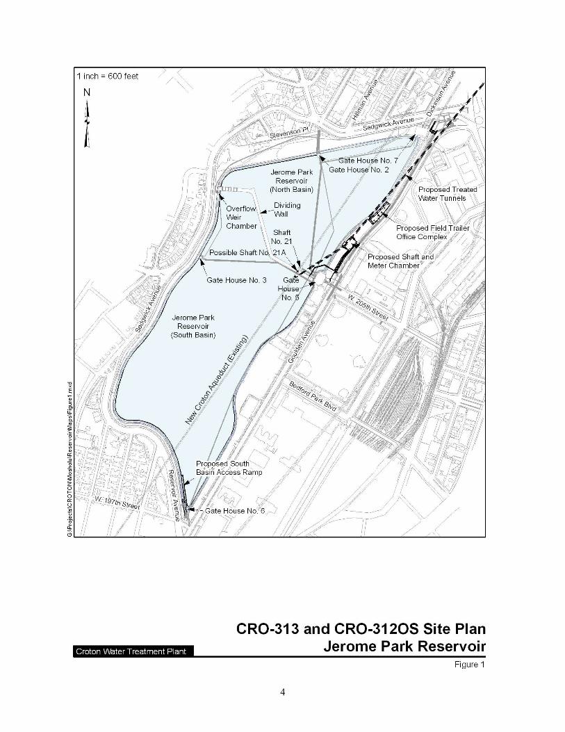
FIGURE 1. CRO-313 AND CRO-312OS SITE PLAN AT JEROME PARK RESERVOIR....... 4 FIGURE 2. CRO-313 AND CRO-312-OS DETAILED LAYOUT OF THE PROPOSED
SHAFT AND METER CHAMBER AREA AT JEROME PARK RESERVOIR ..................5
TABLES
TABLE 1. COMPARISON OF MAIN DESIGN AND CONSTRUCTION CHANGES RELEVANT TO CONTRACTS CRO-313 AND CRO-312OS ............................................ 3
TABLE 2. CRO-313 AND CRO-312OS - TOTAL POTENTIALLY IMPACTED TREES ..... 20 TABLE 3. INTERSECTIONS REQUIRING IMPROVEMENT MEASURES .......................... 26 TABLE 4. RECOMMENDED TIMINGS FOR SEDGWICK AVENUE/GOULDEN
AVENUE/DICKINSON AVENUE INTERSECTION (WEEKDAY A.M. 6:30 – 9:00 AND SATURDAY P.M. 1:30 – 3:30).................................................................................. 27
TABLE 5. RECOMMENDED TIMINGS FOR SEDGWICK AVENUE/GOULDEN AVENUE/DICKINSON AVENUE INTERSECTION (WEEKDAY P.M. 2:30 – 4:30) .... 28
TABLE 6. RECOMMENDED TIMINGS FOR BAILEY AVENUE/VAN CORTLANDT PARK WEST/I-87 NB EXIT RAMP INTERSECTION (WEEKDAY A.M. 6:30 – 9:00) . 28
TABLE 7. RECOMMENDED TIMINGS FOR BAILEY AVENUE/VAN CORTLANDT PARK WEST/I-87 NB EXIT RAMP INTERSECTION (SATURDAY P.M. 1:30 – 3:30) 29
TABLE 8. RECOMMENDED TIMINGS FOR KINGSBRIDGE ROAD/BAILEY AVENUE INTERSECTION (WEEKDAY A.M. 6:30 – 9:00) ............................................................. 29
TABLE 9. RECOMMENDED TIMINGS FOR BAILEY AVENUE/WEST 230TH STREET/I-87 NB EXIT RAMP INTERSECTION (WEEKDAY A.M. 6:30 – 9:00, WEEKDAY P.M. 2:30 – 4:30, AND SATURDAY P.M. 2:30 – 4:30)................................ 30
TABLE 10. EMISSION SUMMARY AND COMPARISON BETWEEN THE BLASTING AND MECHANICAL SCENARIOS................................................................................... 36
TABLE 11. EXISTING AMBIENT CRITERIA POLLUTANT CONCENTRATIONS........... 38

TABLE 12. NEW YORK STATE AMBIENT AIR QUALITY STANDARDS......................... 39 TABLE 13. NYCDEP INCREMENTAL PM2.5 IMPACT GUIDANCE ................................... 39 TABLE 14. PREDICTED CRITERIA POLLUTANT CONCENTRATIONS (BLASTING
SCENARIO) ......................................................................................................................... 40 TABLE 15. PREDICTED MICROSCALE MAXIMUM PM2.5 INCREMENTAL
CONCENTRATIONS (BLASTING SCENARIO).............................................................. 41 TABLE 16. PREDICTED CRITERIA POLLUTANT CONCENTRATIONS
(MECHANICAL SCENARIO) ............................................................................................ 42 TABLE 17. PREDICTED MICROSCALE MAXIMUM PM2.5 INCREMENTAL
CONCENTRATIONS (MECHANICAL SCENARIO) ....................................................... 42 TABLE 18. ON-SITE CONSTRUCTION NOISE RESULTS ................................................... 46 TABLE 19. BLASTING NOISE VERSUS HOE RAM NOISE................................................. 48 TABLE 20. TNM MOBILE NOISE RESULTS ......................................................................... 49 TABLE 21. ESTIMATED EMISSIONS OF NOX AND CO FROM PROPOSED
BLASTING AT JEROME PARK RESERVOIR................................................................. 52 TABLE 22. COMPARISON OF IMPACTS IN CROTON FINAL SEIS AND AS
CURRENTLY PROPOSED IN THE MINOR MODIFICATION ...................................... 54 ATTACHMENT A. HISTORIC AND ARCHAEOLOGICAL RESOURCES
CORRESPONDENCE

1
1. INTRODUCTION This document, a Minor Modification for the Croton Water Treatment Plant (WTP) Final Supplemental Environmental Impact Statement (Final SEIS) CEQR No. 98DEP027, evaluates potential changes in the environmental effects that were presented in the June 2004 Croton WTP Final SEIS due to proposed project revisions. The Final SEIS was prepared by the New York City Department of Environmental Protection (NYCDEP), acting as lead agency, pursuant to the City Environmental Quality Review (CEQR) process as set forth in Executive Order 91 of 1977 and its amendments, and the State Environmental Quality Review Act (SEQRA) and its implementing regulations, as set forth in 6NYCRR Part 617. The subject of the Final SEIS was a proposed project by the NYCDEP to design, construct, and operate a 290 million-gallon-per-day (mgd) WTP to provide filtration and disinfection of the Croton System water supplied to New York City through the New Croton Aqueduct (NCA) and the New Croton Branch Aqueduct (NCBA). The Final SEIS also covered work associated with the construction and operation of the Croton WTP sites remote from the actual water treatment plant site, including locations along the NCA and at the existing and proposed distribution connections in the vicinity of Jerome Park Reservoir (or Reservoir). Since the publication of the Final SEIS, NYCDEP has updated the design and construction plans for activities proposed under Contracts CRO-313 and CRO-312OS. Contract CRO-313 includes construction of two treated water riser shafts in the vicinity of Jerome Park Reservoir to enable flow from the Croton WTP to be conveyed to the water distribution system just east of Jerome Park Reservoir. Contract CRO-312OS includes upgrades and renovations to several gate houses and shafts as well as construction of a Shaft and Meter Chamber (SMC) in the vicinity of Jerome Park Reservoir, which would serve as a central point for distributing treated water from the Croton WTP and measuring flow to the distribution system. The proposed design and construction changes described in this Minor Modification are based on information that was previously not available in earlier stages of design. The proposed revisions would minimize project-related impacts to the area surrounding Jerome Park Reservoir, reduce the project schedule, and enhance regulatory requirements of the design. It is critical that work under Contracts CRO-313 and CRO-312OS be initiated to coincide with the progress of work at the Croton WTP to ensure that these off-site project components are completed and available to convey treated water from the Croton WTP to the City’s water distribution system when the plant commences operation by 2012 in accordance with the Second Supplemental Consent Decree between NYCDEP, New York State Department of Health (NYSDOH), and the U.S. Environmental Protection Agency. The purpose of this environmental analysis is to review the proposed project revisions for their potential to result in significant adverse environmental impacts. This analysis demonstrates that these proposed project revisions would not result in any new or previously undisclosed significant adverse impacts on the environment. Background information on the project and a description of the project design and construction modifications are presented in Section 2. A summary of potential impacts associated with the proposed project design and construction changes is presented in Section 3. A conclusion summarizing the findings of this Minor Modification is presented in Section 4.

2
2. PROJECT BACKGROUND CROTON FINAL SEIS As described in the Final SEIS, construction of the Croton WTP would be accompanied by the construction of a raw water tunnel, raw and treated water pumping stations, and two treated water tunnels. The Croton WTP is currently under construction at the Mosholu Golf Course in Van Cortlandt Park, Bronx, New York. The raw water tunnel would convey water from the NCA to the Croton WTP, while the treated water tunnels would convey filtered water to the vicinity of the Jerome Park Reservoir in the Bronx for distribution to New York City residents. Several gate houses and shafts surrounding the Reservoir also require upgrades and renovations to receive and distribute the treated water. A new shaft chamber and one flow meter chamber would be constructed below-grade in the Harris Park Annex, adjacent to the eastern perimeter wall of Jerome Park Reservoir, and two flow meter chambers would be constructed below-grade in Goulden Avenue. Finally, a new access ramp to the bottom of the Reservoir’s south basin would be constructed. The information presented in the Final SEIS received considerable public review. The public review process began with the issuance of a Lead Agency Determination, Positive Declaration, and Draft Scope of Work on August 22, 2003 by the NYCDEP. Public meetings on the Draft Scope of Work were held September 22 and September 29, 2003. The Final Scope of Work and Response to Comments were released November 4, 2003. The Draft SEIS and Notice of Completion were issued December 31, 2003. Public Hearings were held February 25, 2004 and March 3, 2004 to receive public comments on the Draft SEIS. The public comment period remained open until March 19, 2004. The Final SEIS and Notice of Completion were issued June 30, 2004. UPDATED DESIGN/CONSTRUCTION PLANS FOR THE JEROME PARK RESERVOIR SITE At the time that the Final SEIS was completed, the Croton WTP and associated off-site facility designs were in various stages of design. For instance, the off-site facilities, which had later construction start dates than the WTP, were in more preliminary stages of design than the WTP itself, and, of necessity, the assessments were conducted using the best information and assumptions available at that time. Since completion of the Final SEIS, design has progressed to final design and, as is typical for large scale and complex engineering projects, some changes to the preliminary design and proposed construction methods were made based on information that was previously not available. This section summarizes the changes to design and construction plans that have been identified for the Jerome Park Reservoir area for work relevant to Contracts CRO-313 and CRO-312OS. Table 1 provides a comparison of the main design and construction elements for both contracts that are the subject of this Minor Modification, as discussed in the Final SEIS and as currently proposed. Overall project elements and work locations are identified on Figure 1, while Figure 2 provides a more detailed layout of the proposed Shaft and Meter Chamber area.

3
TABLE 1. COMPARISON OF MAIN DESIGN AND CONSTRUCTION CHANGES RELEVANT TO CONTRACTS CRO-313 AND CRO-312OS
Project Element Contract As Discussed in the Final SEIS As Currently Proposed (Minor Modification)
Approach to Keep Raw and Treated Water Separate in NCA CRO-313 Utilize the existing Shaft No. 21.
Current design includes the possible construction of a new shaft, Shaft No. 21A, if deemed necessary, on the NCA, within the Reservoir’s Dividing Wall; alternative design includes installing a 60-foot plug in the NCA between existing Shaft No. 21 and the Low Level Service connection to the NCA.
Treated Water Tunnel Shafts CRO-313
One large shaft (30 feet diameter) constructed using the raise bore construction method, which would contain two riser shafts.
Two smaller shafts (each 9 feet diameter) constructed using the raise bore construction method.
New Shaft Chamber CRO-312OS
Constructed in the Harris Park Annex to house a single treated water tunnel shaft (described above); soil and bedrock removed using mechanical methods.
Modified shaft and meter chamber constructed in Harris Park Annex to house two treated water tunnel shafts and all flow meters; soil removed using mechanical methods, while bedrock removal would be performed by blasting and mechanical methods.
Flow Meter Chambers CRO-312OS
Two separate Flow Meter Chambers proposed beneath Goulden Avenue, and one Flow Meter Chamber proposed beneath Harris Park Annex south of the Shaft Chamber.
Flow meters would be contained within the single shaft and meter chamber described above; thus, the need for separate Flow Meter Chambers has been eliminated.
Rehabilitation of Gate Houses CRO-312OS
Rehabilitate interior and exterior of Gate House Nos. 2, 3, 5, 6 and 7.
Only interior rehabilitation will be conducted; no exterior work at this time.
Gate House No. 5 CRO-312OS
Remove existing 16-inch diameter raw water pipe between Gate House No. 5 and the Demonstration Plant.
Removal of raw water pipe is being done under a separate project (CRO-315 – Demolition of the Demonstration Plant).
Gate House No. 2 CRO-312OS
Extend 30-inch diameter drain line from the Jerome Park Reservoir Dividing Wall to Gate House No. 2. Extension of drain line not required.
Jerome Pumping Station CRO-312OS
Place off-line; would be used for NYCDEP staff offices. No longer part of project.
Jerome Park Reservoir Walls and Base Slab CRO-312OS No work proposed.
Conduct inspection of the Reservoir walls and base slab; repair as needed.
Emergency Bypass CRO-312OS No work proposed.
Current design includes an emergency bypass connecting the shaft and meter chamber to the NCBA; alternative design includes connecting the Shaft and Meter Chamber to Gate House No. 5.
South Basin Ramp CRO-312OS
Construct ramp in the South Basin in the vicinity of Gate House No. 6.
Construct South Basin Ramp adjacent to Gate House No. 6 along the western wall of the Reservoir; if removal of bedrock is required it would be performed by blasting and/or mechanical methods.
4

5

6
UPDATED DESIGNS Shaft No. 21A In the Final SEIS, the NCA was proposed to be plugged south of NCA Shaft No. 21, and NCA Shaft No. 21 would direct raw water from the Jerome Park Reservoir to the Croton WTP. This was proposed to insure that raw water would not mix with treated water in the NCA. Only minor rehabilitation to NCA Shaft No. 21 was proposed. Since the Final SEIS, it was determined that NCA Shaft No. 21 could not be used because there was insufficient room to utilize Shaft No. 21 for: (1) access to the NCA, and (2) installation of two plugs with an air gap in between, as required by NYSDOH, after their review of design drawings, to insure separation between raw water and treated water in the NCA. Instead of utilizing NCA Shaft No. 21, the updated design plan includes the possible construction of a new shaft, Shaft No. 21A, which would serve to separate the NCA raw water supply and the treated water coming from the Croton WTP. The proposed Shaft No. 21A would be constructed within the Dividing Wall of the Jerome Park Reservoir, approximately 170 feet northwest of Gate House No. 5 and immediately southwest of existing Shaft No. 21, where it would connect to the NCA. Access to the proposed Shaft No. 21A would be from the roadway on the Dividing Wall. A concrete plug would be placed upstream of Shaft No. 21A near NCA Shaft No. 21 to prevent raw water from continuing down the NCA to Manhattan. Another concrete plug would be placed south of Shaft No. 21A just upstream of the new connection from the new Low Service Treated Water Tunnel to the NCA. This would help to direct Low Level Service1 treated water southward down the NCA to Manhattan. Shaft No. 21A would contain the air gap to insure the separation of raw water from treated water. An alternative approach to keep raw and treated water separate in the NCA is being considered that would involve installation of a 60-foot plug between existing Shaft No. 21 and the Low Level Service connection to the NCA. This alternative would not require construction of Shaft No. 21A and is currently under review by NYSDOH. Shaft and Meter Chamber The original design proposed in the Final SEIS included construction of a new Shaft Chamber constructed in the Harris Park Annex, which is City property and not mapped as parkland, approximately 130 feet northeast of Gate House No. 5 containing a single vertical shaft approximately 30 feet in diameter which would contain two riser shafts, one for Low Level Service and one for High Level Service. The new Shaft Chamber would provide a central point for distributing treated water from the Croton WTP to the High Level and Low Level services in the Bronx. Treated water would be conveyed to the single shaft from the Croton WTP by a new combined treated water tunnel containing both a 7-foot diameter High Level Service treated water pipe and a 9-foot diameter Low Level Service treated water pipe. Two separate Flow
1 City water is supplied at three pressures, Low, Intermediate and High, depending on the height above Sea Level of the neighborhoods being served. The Croton System supplies the Low Level service by gravity. Croton water can be supplied to the Intermediate and High Level service by pumping the water. The Catskill/Delaware system supplies the High Level service by gravity. The High Level service pressure can be reduced in the distribution system to supply the other systems.

7
Meter Chambers (2 meters in each chamber) were proposed to be located beneath Goulden Avenue, and one Flow Meter Chamber (1 meter) was proposed to be located beneath Harris Park Annex and south of the Shaft Chamber. Under the updated design plan, a modified shaft and meter chamber (SMC) is proposed in the Harris Park Annex approximately 380 feet northeast of Gate House No. 5. Two 48-inch Low Level Service water mains, one 48-inch High Level Service water main, and one 84-inch water main would connect the SMC to the distribution system, requiring yard pipe installation within the Harris Park Annex between the SMC and Gate House No. 5. The SMC would contain two individual shafts, each approximately 9 feet in diameter, and the five flow meters discussed above, eliminating the need for the separate Flow Meter Chambers, including the two originally considered for placement in Goulden Avenue. The two riser shafts are required because the Croton WTP is designed to provide water at two different pressures. One riser supplies connections to the Low Service distribution piping serving the east and south Bronx and the second riser supplies connections to the High Service system to City Tunnels No. 1 and No. 3. The two pressure zones maximize flexibility for operations in the event that the NCA is out of service and maximize yield during droughts. The design capacity of the Croton WTP exceeds the demand of the Low Service system, so any production in excess of Low Service demand must be pumped into the High Service system. During droughts, NYCDEP needs the full capacity of the Croton system to maximize yield and provide potable water supply to the City. If required, the Croton WTP High Service pumps have capacity to lift the entire production of the plant into the High Service system. While this redesign would result in greater excavation than was required under the previous design, the location and layout of the SMC was designed to consolidate activities further away from nearby schools and reduce disruption to traffic in the street. The new design would also provide easier access for water sampling and maintenance. The two shafts would be constructed under Contract CRO-313; the chamber and flow meters would be built subsequently under Contract CRO-312OS. Instead of conveying treated water to the SMC via two pipes within one combined treated water tunnel, two separate tunnels are now proposed (one carrying Low Level Service treated water and one carrying High Level Service treated water) that would connect to the two distribution shafts in the SMC. The current design includes an emergency bypass connecting the SMC to the adjacent NCBA. This would provide the City with the ability to supply water from Jerome Park Reservoir to the City’s Low Level Service distribution system in the event of a major power outage or other emergency. An alternative emergency bypass design is being considered that would connect the SMC to Gate House No. 5. If adopted, the alternative emergency bypass would increase the length of the yard piping by approximately 40 feet. Rehabilitation of Gate Houses Under the plan presented in the Final SEIS, work was proposed at the five Jerome Park Reservoir gate houses, including exterior and interior rehabilitation, as well as operational modifications. However, when plans for the exterior rehabilitation work were presented to the Art Commission of New York City (now known as the Public Design Commission), concerns were voiced from the community related to a newly constructed security fence built around the Reservoir. As a result, the NYCDEP withdrew this aspect of project until they could respond to

8
the questions raised by the Public Design Commission. To avoid a delay in the bidding process for Contract CRO-312OS, which in turn could cause NYCDEP to miss Consent Decree milestones, it is likely that the rehabilitation of Gate Houses 2, 3, 5, 6, and 7 under Contract CRO-312OS will be limited to interior work only, with the exterior modifications performed later under CRO-312OS as a change order or under another contract. Regardless of whether this work is performed under CRO-312OS as a change order or under another contract, there is now planned only minor changes in the proposed exterior modifications to the Gate Houses as compared to those presented in the Final SEIS. As described below, operational work originally proposed in the Final SEIS for Gate Houses 2 and 5 has also been modified; this work would also be conducted under Contract CRO-312OS. Gate House No. 5 In the project as proposed in the Final SEIS, the 16-inch raw water connection from the Demonstration Plant to Gate House No. 5 would be removed. Removal of this connection was included in Contract CRO-315G, which contains changes to the chlorination system in Gate House No. 5 and demolition of the Demonstration Water Treatment Plant. Construction work on Contract CRO-315G started earlier this year. Therefore, removal of the 16-inch raw water pipe is no longer required under CRO-312OS. Gate House No. 2 In the original design proposed in the Final SEIS, a 30-inch drain line would be extended from the dividing wall approximately 700-feet to Gate House No. 2, where it would be connected to the Reservoir drain. The objective of the proposed extension was to allow the south basin to be drained without having to use a diver to remove the blind flange to the drain inlet located on the Reservoir floor. However, this work will not be included under Contract CRO-312OS because the work is no longer necessary. NYCDEP has already constructed a platform outside Gate House No. 3 which can control a valve to drain the South Basin independently from the North Basin thus making the extension of the 30-inch drain line redundant, and thus, not required. Jerome Pumping Station In the Final SEIS, the Jerome Pumping Station was proposed to be taken off line, but retained for NYCDEP use. The pumping station is currently equipped to receive Low Level Service treated water from Jerome Park Reservoir and pump it into the Intermediate Service zone in this area of the Bronx. NYCDEP has recently indicated they may want to convert this facility into a hydraulic pumping station and use High Level Service water in the area to operate new turbines and discharge Low Level Service water into the Intermediate Service. Pending a final decision regarding its future use, work on the Jerome Pumping Station has been removed from Contract CRO-312OS. UPDATED CONSTRUCTION PLANS Shaft No. 21A For Shaft No. 21A, if deemed necessary, surface excavation would be required to remove granular backfill and concrete within the Dividing Wall, and bedrock below the Dividing Wall for the new shaft would be excavated by the raise bore method described for the other shafts below. The rock excavated by the raise bore would be dropped into the NCA where it would be transported through the new Low Level Service treated water tunnel back to the Croton WTP Site for removal and disposal. The granular backfill would either be stored on site for reuse or

9
would be trucked off site. The alternative approach of installing a plug in the NCA south of Shaft No. 21 would not require any surface excavation or removal of bedrock since access to the NCA would be through Shaft No. 21. Shaft and Meter Chamber The Final SEIS stated that construction of the new shaft in the Shaft Chamber (as originally designed) would be done using the raise bore construction method. This method involves drilling of a pilot hole from the surface, assembly of the raise bore at the bottom of the shaft where the new treated water tunnel would terminate, and excavation of the rock by the raise bore moving in an upward direction cutting the rock as it moves. Boring spoils would fall into the tunnel and would be removed at the Croton WTP site via the new treated water tunnel. Although the excavation method was not fully described, the Final SEIS indicated that surface excavation (including soil and bedrock removal) would be necessary for the Shaft Chamber and noted that mechanical construction activity would involve the use of one crane, one backhoe/loader, and trucks. In order to remove bedrock, the mechanical excavation process would require use of hoe-ramming, which involves attaching a hydraulic jack hammer to an excavator or backhoe. Under CRO-313, both treated water tunnel shafts proposed in the SMC would still be constructed using the raise bore method as described above, and surface excavation for the portion of the SMC area to be excavated under Contract CRO-313 would be conducted using the same type of mechanical excavation method addressed in the Final SEIS. Since there has been no modification to the proposed construction method, impacts associated with construction of the two shafts are not the subject of this Minor Modification. Surface excavation for the remaining portion of the SMC area to be excavated under Contract CRO-312OS would be conducted down to bedrock (approximately 26 feet below ground surface) using the same type of mechanical soil excavation addressed in the Final SEIS. Under the updated Contract CRO-312OS construction plan, overburden removal would still be done via mechanical means and bedrock removal to an average depth of 10 feet would occur with the use of blasting. Blasting is also proposed for rock removal for the yard piping associated with the SMC. A discussion of the blasting method and anticipated benefits as compared to hoe-ramming (mechanical method) is provided below. This evaluation concluded that from a technical and environmental perspective the blasting rock removal method is the best technique to use for bedrock removal for the consolidated SMC, which is now an area of approximately 95 feet by 135 feet. Jerome Park Reservoir Walls and Base Slab Inspection and repair of the Reservoir walls and base slab is currently proposed under Contract CRO-312OS. The Final SEIS did not propose any such work. Although the inspection and repair work to be conducted under Contract CRO-312OS represents a change from the project scope presented in the Final SEIS, any structural repairs to the Reservoir walls and base slab resulting from the proposed inspection are anticipated to be very minor, such as repairing cracks and repointing concrete. Therefore, no potential significant adverse impacts are anticipated to occur based on the nature of this work. South Basin Ramp The Final SEIS proposed that an access ramp to the South Basin be constructed in the vicinity of Gate House No. 6. However, the method of bedrock removal for this task was not described.

10
Construction of the South Basin Ramp, adjacent to Gate House No. 6 along the western wall of the Reservoir, is proposed for inclusion under Contract CRO-312OS. If removal of bedrock is required, construction would include either mechanical or blasting methods. Currently, the recommended method of bedrock removal has not been determined. Therefore, this Minor Modification includes a potential impact analysis for both bedrock removal options. Blasting Method For construction of the SMC and SMC yard piping, blasting would require placement of blasting caps and explosive charges within holes drilled in the bedrock. Blast detonations may occur up to approximately 36 times over approximately three months of construction at the SMC and approximately 20 times over approximately one month for the SMC yard piping. Detonating the explosive charges would last only a few seconds. By comparison, backhoes and hoe-rams would be anticipated to operate nearly continuously during the construction day if rock removal were by mechanical means alone. With blasting, the backhoes and hoe-rams would only be used intermittently (for breaking rock loosened by explosives into smaller pieces). In addition, the explosive charges for the SMC and associated yard piping would be conducted approximately 20 feet below grade. Furthermore, in order to avoid disturbing students in the Bronx High School of Science the blasting would be timed to occur after school hours approximately three to five times a week. For construction of the South Basin Ramp (if the blasting method is selected), blasting detonations may occur approximately 15 times over approximately one month of construction. Blasting charges for the South Basin Ramp would be conducted almost 30 feet below grade. The majority of work required for construction of the South Basin Ramp would occur within the south basin and would be surrounded by the walls of the Reservoir, which would provide natural noise attenuation. As a result, predicted noise levels at nearby schools and residences for this activity are expected to comply with all applicable noise criteria levels. Use of blasting is the quickest method to remove bedrock and would conservatively shorten the duration of the rock excavation as compared to mechanical rock removal (approximately three months vs. approximately six months for the SMC; approximately one month vs. approximately two months for the SMC yard piping; approximately one month vs. approximately two months for the South Basin Ramp), thereby minimizing the inconvenience of this work to the surrounding community. The proposed blasting would involve development and implementation of a controlled blasting program that would both control excessive vibration and minimize risk of damage to adjacent aqueducts and to nearby structures. The Contractor would be required to prepare and implement a Blasting Plan to protect workers and the public (including students in the nearby schools and residents in the nearby homes). The Blasting Plan would be subject to approval by the Fire Department of the City of New York (FDNY). Blasting procedures are developed on a site-specific basis depending on geological conditions as well as traffic and other environmental conditions at the time of blasting. Controlled drilling and blasting involves drilling many small (i.e., 2.5-inch diameter) holes in the rock using rock drills, and then placing small amounts of explosives in each hole. Blast mats are then placed on the rock to control potential flying debris during blasts. Under carefully controlled and monitored conditions, explosives are then detonated sequentially, breaking the rock while spreading the release of energy from individual explosives, lessening the potential ground vibration and air blast effects above.

11
When blasting would be conducted, one to two blasts would be expected to occur on a given day. The typical blasting sequence is as follows:
Drilling of blast holes Placement of explosives Placement of blasting mats Clearing area in vicinity of blast Detonation of explosives Removal of blast mats Removal of rock
Blasting would be conducted in a manner that is protective of public health and safety, as regulated by FDNY. As typically performed throughout the City, a few minutes prior to blasting, warning whistles would alert the area that blasting was about to begin. The typical warning whistle communication protocol could result in the halting of vehicular and pedestrian traffic near the blast site as follows: 1 long whistle - vehicular and pedestrian traffic stopped by flag persons 2 short whistles - blast would commence 3 long whistles - all clear: blast is completed and traffic flow can resume This warning whistle communication protocol could take up to five minutes to implement. NYCDEP and its contractor would conduct extensive outreach to those in the vicinity of the site that could be affected by blasting. This would include providing the nearby community with the expected start date for blasting operations, the general time pattern during the ensuing months, and the timing and significance of the warning whistles. Qualified specialists would conduct a pre-blast survey of the Bronx High School of Sciences, the JPR East Perimeter Wall, Gate House No. 5, the NCBA, and other nearby buildings as necessary to document the conditions prior to blasting. The surveys would thoroughly document all existing cracking damage or defects to both the interior and exterior of all structures and facilities. Post-blast surveys would also be conducted. Potential impacts associated with the blasting method are further evaluated in the next section of this Minor Modification, and impacts with respect to mechanical rock removal are presented for comparison where applicable.

12
3. POTENTIAL IMPACTS FROM THE PROPOSED MODIFICATIONS This section summarizes the evaluation of potential impacts that could result from the proposed modification in the design and construction plans for work under Contracts CRO-313 and CRO-312OS. Discussion is limited to activities that would affect the Jerome Park Reservoir study area, including: construction of Shaft No. 21A, construction of the SMC and associated piping, construction of the South Basin Ramp, and rehabilitation of the Gate Houses. Impacts related to the modification of the treated water tunnels are not presented since all work would occur below ground and all excavated materials would be trucked away through the tunnels as they are constructed and removed at the Croton WTP Site, as previously described in the Final SEIS. The location of the new SMC shortens the raw water and treated water tunnels from the original design, thus reducing the amount of excavated material that would have been trucked through the tunnels and removed from the WTP Site. Also, the one large 30 feet diameter shaft would have created more excavation, both at the Jerome Park Reservoir Site as well as down into the tunnel, than the two smaller shafts in the new design. Effects of these changes are discussed in the context of potential impacts from construction activities disclosed in the Final SEIS. For several of the environmental impact areas, the proposed modifications do not substantially change the analyses described in the Final SEIS. Thus, they are not discussed in this Minor Modification. These impact areas include:
Land Use, Zoning, and Public Policy Socioeconomic Conditions Community Facilities Open Space Shadows Visual Resources Hazardous Materials Water Resources Solid Waste Energy Transit and Pedestrians Environmental Justice
For the remaining environmental analysis subjects, the proposed changes in design and construction activities have the potential to result in changes to impacts disclosed in the Final SEIS, and are therefore being evaluated in this document. These subjects are discussed in more detail in the following sections. A summary of the previously disclosed impacts (Conclusions from the Croton WTP Final SEIS) is reported first, followed by the conclusions in this report (Minor Modification Update). A detailed resource loading schedule was developed to aid in the analysis of potential impacts. The resource loading schedule includes a construction activity schedule and identifies the number of workers and number and type of equipment and vehicles required to carry out the proposed activities. The proposed construction schedule spans a period of approximately four years (from 2008 to 2012), and several construction activities are anticipated to overlap throughout the schedule. It is important to note that the resource loading schedule was developed

13
for planning purposes only. The proposed construction dates were fixed in October 2008 at the time the Minor Modification was being prepared. Actual construction activity dates may change depending on construction conditions; however, minor schedule changes are not anticipated to meaningfully affect the conclusions reached in this document. Using information contained in the resource loading schedule, “peak years” were identified for the following technical environmental analysis subjects: Traffic, Air Quality, and Noise. The peak year selected for each subject was used to conduct impact analyses for the reasonable worst-case scenario. A brief explanation of the peak year selected for these environmental analysis subjects is provided below. Additional peak year information is presented in the following Minor Modification Update sections for these subjects.
Traffic: A peak construction year of 2011 was selected since the greatest number of vehicle trips would be generated for a peak hour during this year as a result of the construction activities scheduled to occur, and it represents the highest background traffic volumes for the construction period.
Air Quality: A peak construction year of 2009 was selected since it is anticipated to have the greatest activity (i.e., most pieces of equipment), as well as the highest potential emissions (e.g., exhaust, fugitive dust), as a result of the construction activities scheduled to occur during this year.
Noise: Rather than selecting a specific peak year for the impact analysis, potential worst-case (i.e., loudest) noise conditions were analyzed to evaluate the potential loudest hour during each month of work during the project duration (2008-2012).
No long-term operational changes are proposed since the project components under Contracts CRO-313 and CRO-312OS would remain below-grade or within existing structures upon completion, would represent an extension of the existing use, and would not substantially expand the capacity of the site. Therefore, only an evaluation of construction impacts is presented in this document. HISTORIC AND ARCHAEOLOGICAL RESOURCES CONCLUSIONS FROM THE CROTON WTP FINAL SEIS As discussed in the Croton WTP Final SEIS, the Jerome Park Reservoir and adjacent associated buildings and structures are listed on both the National and New York State Registers of Historic Places. The Final SEIS concluded that the project, which included mechanical rock removal, would not significantly affect historic structures since none of the proposed work would appreciably affect building facades or the historic context of the Jerome Park Reservoir. Additionally, the New York State Office of Parks, Recreation and Historic Preservation (OPRHP) and the Secretary of the Interior’s Standards for the Treatment of Historic Properties were consulted to retain the historic character of the structures and ensure that the proposed project would not cause a significant adverse impact to the historic structures.

14
MINOR MODIFICATION UPDATE A Memorandum of Agreement (MOA) was established in July 2000 between the New York State OPRHP, the New York State Historic Preservation Office (SHPO) and the NYCDEP regarding the overall plans to integrate the proposed Croton WTP into the City’s existing water supply system. This integration entails work to be performed on some of the off-site facilities that are currently part of the Croton Water Supply System. A Cultural Resources Assessment for Contract CRO-313 was prepared in February 2006 to further evaluate potential impacts to historic and archaeological resources. The report determined that the locations of the two treated water riser shafts in the revised design would not impact any historic or archaeological resources due to two factors: (1) the project Area of Potential Effect within the Harris Park Annex was drastically altered during the extensive excavations for the Reservoir and (2) the shafts would not alter the integrity of the historic Reservoir structure. OPRHP concurred with this assessment (OPRHP, March 17, 2006; included in Attachment A). According to the Cultural Resources Assessment for Contract CRO-313, no historic structures would be affected by the construction of the proposed Shaft No. 21A because it would only be connected to new Reservoir elements. Shaft No. 21A would be constructed inside the existing Reservoir Dividing Wall, which was constructed from 1987 to 1989, and would not be visible outside of the walls of the Reservoir. The surface of the shaft would be flush with the existing Dividing Wall roadway. As originally proposed, construction would entail excavation through bedrock. A Cultural Resources Assessment for Contract CRO-312OS was prepared in August 2007 to fulfill the OPRHP review procedures and address potential impacts to Gate Houses 1, 2, 3, 5, 6, 7 and Mosholu Pumping Station, Jerome Park Reservoir Overflow Weir, and demolition of the non-historic Microstrainer Building adjacent to Gate House No. 6. All proposed work is directly related to the construction and operation of the Croton WTP. OPRHP concluded that the proposed work conforms to the Secretary of the Interior’s Standards for the Treatment of Historic Properties and the terms of the MOA, and would have no adverse impact of these historic resources (OPRHP, September 25, 2007; included in Attachment A). The updated plans, under Contract CRO-312OS, call for the blasting of rock for the construction of the SMC and associated yard piping. At the closest approach, excavation of the SMC would come within ten feet of the NCBA and the Jerome Park Reservoir perimeter wall, both of which are historic structures. A vibration analysis was conducted to address concerns regarding potential damage to these nearby structures from construction activities. The blasting alternative and mechanical excavation alternative were evaluated. FDNY does not set vibration criteria for underground structures; however, for Contract CRO-312OS construction, a review level criterion of 1.5 inches per second (ips), as well as an alert level criterion of 3.0 inches per second, was set for both historically sensitive structures. Review Level is the first and lowest instrument reading at which blasting methods would be reviewed if vibration was persistently above that level. Blast design changes would be made such as amending explosive round lengths, pounds per delay, and number of blast holes as required to achieve a reduction in vibration readings.
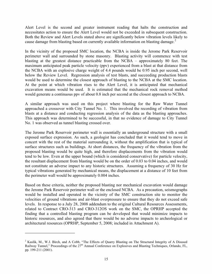
15
Alert Level is the second and greater instrument reading that halts the construction and necessitates action to ensure the Alert Level would not be exceeded in subsequent construction. Both the Review and Alert Levels stated above are significantly below vibration levels likely to cause damage from blasting based on currently available information on blasting damage.2 In the vicinity of the proposed SMC location, the NCBA is inside the Jerome Park Reservoir perimeter wall and surrounded by stone masonry. Blasting activity will commence with test blasting at the greatest distance practicable from the NCBA – approximately 80 feet. The maximum anticipated peak particle velocity (ppv) experienced from a blast at that distance from the NCBA with an explosive charge weight of 4.4 pounds would be 0.95 inch per second, well below the Review Level. Regression analysis of test blasts, and succeeding production blasts would be used to determine the closest approach of blasting to the NCBA at the SMC location. At the point at which vibration rises to the Alert Level, it is anticipated that mechanical excavation means would be used. It is estimated that the mechanical rock removal method would generate a continuous ppv of about 0.8 inch per second at the closest approach to NCBA. A similar approach was used on this project where blasting for the Raw Water Tunnel approached a crossover with City Tunnel No. 1. This involved the recording of vibration from blasts at a distance and conducting regression analysis of the data as the blasting approaches. This approach was determined to be successful, in that no evidence of damage to City Tunnel No. 1 was observed as tunnel blasting crossed over. The Jerome Park Reservoir perimeter wall is essentially an underground structure with a small exposed surface expression. As such, a geologist has concluded that it would tend to move in concert with the rest of the material surrounding it, without the amplification that is typical of surface structures such as buildings. At short distances, the frequency of the vibration from the proposed blasting would be quite high, and therefore displacements from the vibration would tend to be low. Even at the upper bound (which is considered conservative) for particle velocity, the resultant displacement from blasting would be on the order of 0.03 to 0.04 inches, and would not constitute an adverse impact to any historic structures. Assuming a frequency of 30 Hz for typical vibrations generated by mechanical means, the displacement at a distance of 10 feet from the perimeter wall would be approximately 0.004 inches. Based on these criteria, neither the proposed blasting nor mechanical excavation would damage the Jerome Park Reservoir perimeter wall or the enclosed NCBA. As a precaution, seismographs would be installed and operated in the vicinity of the SMC construction site to monitor the velocities of ground vibrations and air-blast overpressure to ensure that they do not exceed safe levels. In response to a July 28, 2008 addendum to the original Cultural Resources Assessments, related to Contract CRO-313 and CRO-312OS work on the SMC, the OPRHP accepted the finding that a controlled blasting program can be developed that would minimize impacts to historic resources, and also agreed that there would be no adverse impacts to archeological or architectural resources (OPRHP, September 5, 2008; included in Attachment A).
2 Kaslik, M., W.J. Birch, and A Cobb, “The Effects of Quarry Blasting on The Structural Integrity of A Disused Railway Tunnel,” Proceedings of the 27th Annual Conference on Explosives and Blasting Techniques, Orlando, FL, pp. 199-211 (2001).

16
An additional Phase IA addendum documenting the results of a vibration analysis conducted within the South Basin Ramp construction area was submitted to OPRHP for review (OPRHP, December 29, 2008; included in Attachment A). This analysis reflected the potential need to employ blasting techniques during excavation. The historic structures in the immediate vicinity of the South Basin Ramp proposed excavation include the Jerome Park Reservoir Wall (south-west side), and Gate House No. 6. At the closest approach, excavation of the South Basin Ramp would come within ten feet of the Jerome Park Reservoir perimeter wall. An approach similar to that for the SMC would be used to determine at what point the blasting rock removal method would need to be changed to mechanical excavation, based upon analysis of blasting records obtained from the test blasts. The maximum ppv from mechanical excavation would be even lower at approximately 0.80 inch per second. Therefore, the use of either the blasting or the mechanical method for rock excavation related to construction of the South Basin Ramp is not anticipated to result in an adverse impact to the historic water supply structures in the vicinity of Jerome Park Reservoir. As a precaution, seismographs would be installed and operated in the vicinity of the South Basin Ramp construction site to monitor the velocities of ground vibrations and air-blast overpressure to ensure that they do not exceed safe levels. Construction of the emergency bypass may require either demolishing and removing a small portion of the Reservoir’s wall for the installation of a 60-inch jacking sleeve and two 60-inch WTP bypass connections to the NCBA, or connecting to three 48-inch mains in the front of Gate House No. 5. Both options were reviewed and approved by OPRHP and found to have no adverse impact on historic resources (OPRHP, September 25, 2007 and January 26, 2009; included in Attachment A). If the emergency bypass option selected consists of installing a header and three 48-inch pipe connections into the open bay in Gate House No. 5, the existing stairs on the east side of the gate house that were reconstructed in 1988 would be removed to install the water mains and then replaced in kind. However, if the emergency bypass alternative that requires connections to Gate House No. 5 is selected, OPRHP would be consulted and a detailed description of the undertaking would be prepared, including any removal and reconstruction that would affect the exterior of Gate House No. 5. NEIGHBORHOOD CHARACTER CONCLUSIONS FROM THE CROTON WTP FINAL SEIS As described in the Final SEIS, no significant adverse impacts are anticipated on neighborhood character at the Jerome Park Reservoir or in the surrounding area as a result of construction of the proposed facilities. Jerome Park Reservoir, while having a substantial presence in the neighborhood, does not dominate the neighborhood in which it is surrounded. The neighborhood surrounding the Reservoir is characteristic of typical multi-use neighborhoods that contain a variety of urban environments. Jerome Park Reservoir was built, and is maintained, for water supply purposes. The proposed construction activity around Jerome Park Reservoir for the Croton WTP project, although of several years in duration, is on a scale of typical urban utility work. The presence of construction equipment around the Reservoir would not cause any substantial changes to the visual character of the project area. The mechanical method proposed for bedrock removal for construction of the shaft chamber would require continuous drilling and hoe ram activity over an 8-hour work day. However, as stated in the Final SEIS, a noise attenuating barrier would be installed for the duration of construction to reduce construction-
17
generated noise to levels that are less than the 3-5 dBA CEQR guidance level and minimize disruption to nearby sensitive receptors. The proposed construction and facility modifications would be consistent with historic water supply activity at this site. Therefore, the construction at the site was anticipated to not cause a significant impact to the neighborhood character. MINOR MODIFICATION UPDATE The neighborhood character of the area surrounding the Jerome Park Reservoir would not be altered as a result of the proposed modification in the design and construction plans since construction and facility modifications would not alter the proposed continuation of the historic water supply use activity or result in new structures that could alter the character of the site. As previously stated, surface excavation for the SMC area to be excavated under Contract CRO-312OS and the associated yard piping between the SMC and Gate House No. 5 would require removal of bedrock, which would be best accomplished using blasting. Based on the area and depth of rock excavation and type of rock, it is conservatively assumed that blast detonations may occur up to approximately 36 times over approximately three months of construction of the SMC, and up to approximately 20 times over approximately one month of construction for the yard piping. Detonating the explosive charges would last only a few seconds. Use of blasting is the best method to remove bedrock and would shorten the duration of the rock excavation as compared to mechanical rock removal (approximately three months vs. approximately six months for the SMC, and approximately one month vs. approximately two months for the yard piping). The proposed blasting would involve development and implementation of a Blasting Plan to protect workers and the public, as described in the Project Background section of this Minor Modification. The public would be notified about the blasting program. In coordination with the FDNY, blasting would be timed to occur after school hours in order to avoid disturbing students in the Bronx High School of Science. Blasting would be limited to one to two blasts on a given day. To address the need to control potential vibrations from the blasting program, seismographs would be installed and operated to monitor the velocities of ground vibrations and air-blast overpressure resulting from construction activities at the Jerome Park Reservoir in the vicinity of the shafts. If blasting is selected as the preferred method for removal of bedrock for construction of the South Basin Ramp (which would require approximately 15 detonations in approximately one month) the same Blasting Plan precautions would be taken for this component of the project. Excavation of the riser shafts would still be performed by raise bore as disclosed in the Croton Final SEIS, and this method would also be employed for the possible construction of Shaft No. 21A. All proposed SMC rock removal activity, which would be the noisiest construction activity associated with Contracts CRO-313 and CRO-312OS, would be screened from the surrounding area by 14 to 20-foot tall noise attenuation barriers. With the use of the noise attenuation barriers, the excavation activity for constructing the SMC is expected to comply with applicable CEQR noise guidance levels. The majority of work required for construction of the South Basin Ramp would occur within the south basin and would be surrounded by the walls of the Reservoir, which would provide natural noise attenuation. Additional detail regarding potential noise impacts due to the proposed modifications is discussed below under Noise.

18
The SMC is proposed to be located further away from the Bronx High School of Science as compared to the originally proposed locations of the Flow Meter Chambers and Shaft Chamber, which is anticipated to help minimize construction-related impacts to this sensitive receptor since construction activity would be consolidated in one location at a greater distance from the school. Vegetation (primarily mowed grasses and some trees) in the Harris Park Annex would be disturbed during construction of the SMC and associated yard piping; however, this vegetation would be restored to the extent practicable following completion of the SMC. Air quality impacts resulting from the proposed modifications are anticipated to be minimal and thus would not impact natural resources or members of the public in the surrounding community. It should be noted that since the issuance of the Final SEIS, Local Law 77 was promulgated. The equipment utilized as part of the proposed work at Jerome Park Reservoir would be operated in compliance with Local Law 77. Further discussion concerning Local Law 77 is provided below under Air Quality. The proposed modifications would result in an increase in construction-related traffic to the road network as compared to what was presented in the Final SEIS due to increased surface excavation requirements and a proposed shorter excavation period with the implementation of blasting. However, the small number of total project-induced traffic is anticipated to result in minimal impact to traffic on area roadways. Also, the effect of increased construction-related traffic would be offset by the reduction of traffic disruptions due to the elimination of two large Flow Meter Chambers in Goulden Avenue close to the Bronx High School of Science, which would have required lane closures for extended periods. Further detail on the traffic-related effect of the proposed modifications is discussed below under Traffic and Transportation. The project modifications in and around Jerome Park Reservoir during the construction period would have an adverse effect on neighborhood character, but not a significant adverse impact on neighborhood character. The activities associated with construction have the potential to create increased noise levels and would be a nuisance from the increased trucking levels in the community. Construction work and the barriers erected to control noise levels may temporarily impair the visual quality of this area. The project modifications would not have the potential to rise to the level of significant adverse community character impacts, because the proposed construction would be predominantly underground and when completed would not appreciably change land use patterns or the way in which the land is used. NATURAL RESOURCES CONCLUSIONS FROM THE CROTON WTP FINAL SEIS As discussed in the Final SEIS, the Jerome Park Reservoir is a drinking-water balancing Reservoir for the Croton Water Supply System. The Jerome Park Reservoir property consists of the Reservoir surrounded by two sets of perimeter fences that separate the Reservoir from the surrounding streets. Disturbed areas with maintained vegetation surround the majority of the Reservoir. Trees within the study area include: tree-of-heaven, sugar maple, tuliptree, white mulberry, eastern sycamore, black cherry, pin oak, and northern red oak. Mowed grass, herbs, and vines are also present within the disturbed areas between the two perimeter chain link fences. No wetlands or waterways were located on Jerome Park Reservoir site. The Reservoir is actively managed through chlorination to deter fish and benthic macroinvertebrate communities. No
19
known state or federally listed endangered, threatened, or rare species are present within the Reservoir study area. Jerome Park Reservoir lacks suitable habitat to support herpetile communities. An ongoing bird abatement program discourages birds from using the Reservoir. Birds seen during the survey days and those expected to visit urbanized areas, such as those surrounding Jerome Park Reservoir include: wood duck, red-tailed hawk, red-bellied woodpecker, blue jay, tufted titmouse, and American goldfinch. Potential habitat for small rodents, rabbits, and raccoons includes dense herbaceous vegetation behind the Demonstration Water Treatment Plant, the dense woody vegetation located north of Gate House No. 5, and along the fence line. The chain link fences and the entirely urban surroundings prohibit larger mammals from entering the Reservoir area. Gray squirrels and a Norway rat were observed during site investigations. Other mammals potentially occurring within the vicinity of the Reservoir include: Virginia opossum, Eastern mole, bats, Eastern cottontail, house mouse, raccoon, and striped skunk. Although not quantified in the Final SEIS, the earlier design of the Shaft Chamber (as originally designed) would have required the potential removal or pruning of four trees within the Harris Park Annex: multi-stem white mulberry (13 dbh3, 8 dbh, 8 dbh, 8 dbh, and 12 dbh); Siberian elm (13 dbh); black cherry (8 dbh); and sycamore maple (16 dbh). The Harris Park Annex is a previously disturbed area with mowed grass that is interspersed with trees. Construction of the Flow Meter Chamber A, which was also originally designed to be located in Harris Park Annex, would not impact any trees. Flow Meter Chambers B and C were designed to be located in Goulden Avenue and would also not affect any trees. MINOR MODIFICATION UPDATE The redesign of the SMC and yard piping within Harris Park Annex would result in the removal 27 trees. It is estimated that 18 additional trees, whose drip lines extend within 20 feet of the construction area, are considered potentially threatened by construction activities. Table 2 lists the potentially impacted species of trees, their diameter at breast height (dbh), and whether they would be cut or threatened as a result of the proposed project. No natural resources would be impacted by the construction of the proposed Shaft No. 21A because the construction would occur within the gravel filled U-shaped concrete Jerome Park Reservoir Dividing Wall, which is devoid of vegetation or habitat for wildlife.
3 DBH = Diameter at Breast Height
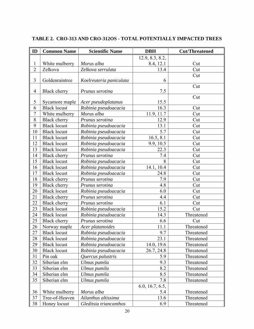
20
TABLE 2. CRO-313 AND CRO-312OS - TOTAL POTENTIALLY IMPACTED TREES
ID Common Name Scientific Name DBH Cut/Threatened
1 White mulberry Morus alba 12.9, 8.3, 8.2,
8.4, 12.1 Cut 2 Zelkova Zelkova serrulata 13.4 Cut
3 Goldenraintree Koelreuteria paniculata 6Cut
4 Black cherry Prunus serotina 7.5Cut
5 Sycamore maple Acer pseudoplatanus 15.5Cut
6 Black locust Robinia pseudoacacia 16.3 Cut 7 White mulberry Morus alba 11.9, 11.7 Cut 8 Black cherry Prunus serotina 12.9 Cut 9 Black locust Robinia pseudoacacia 13.1 Cut 10 Black locust Robinia pseudoacacia 5.7 Cut 11 Black locust Robinia pseudoacacia 16.5, 8.1 Cut 12 Black locust Robinia pseudoacacia 9.9, 10.5 Cut 13 Black locust Robinia pseudoacacia 22.3 Cut 14 Black cherry Prunus serotina 7.4 Cut 15 Black locust Robinia pseudoacacia 8 Cut 16 Black locust Robinia pseudoacacia 14.1, 10.4 Cut 17 Black locust Robinia pseudoacacia 24.8 Cut 18 Black cherry Prunus serotina 7.9 Cut 19 Black cherry Prunus serotina 4.8 Cut 20 Black locust Robinia pseudoacacia 6.0 Cut 21 Black cherry Prunus serotina 4.4 Cut 22 Black cherry Prunus serotina 6.1 Cut 23 Black locust Robinia pseudoacacia 15.2 Cut 24 Black locust Robinia pseudoacacia 14.3 Threatened 25 Black cherry Prunus serotina 6.6 Cut 26 Norway maple Acer platanoides 11.1 Threatened 27 Black locust Robinia pseudoacacia 9.7 Threatened 28 Black locust Robinia pseudoacacia 23.1 Threatened 29 Black locust Robinia pseudoacacia 14.0, 19.6 Threatened 30 Black locust Robinia pseudoacacia 26.7, 24.8 Threatened 31 Pin oak Quercus palustris 5.9 Threatened 32 Siberian elm Ulmus pumila 9.3 Threatened 33 Siberian elm Ulmus pumila 8.2 Threatened 34 Siberian elm Ulmus pumila 8.5 Threatened 35 Siberian elm Ulmus pumila 7.8 Threatened
36 White mulberry Morus alba 6.0, 16.7, 6.5,
5.4 Threatened 37 Tree-of-Heaven Ailanthus altissima 13.6 Threatened 38 Honey locust Gleditsia triancanthos 6.9 Threatened

21
TABLE 2. CRO-313 AND CRO-312OS - TOTAL POTENTIALLY IMPACTED TREES
ID Common Name Scientific Name DBH Cut/Threatened 39 Honey locust Gleditsia triancanthos 2.3 Cut 40 Siberian elm Ulmus pumila 10.2 Threatened 41 Siberian elm Ulmus pumila 9.2 Threatened 42 Willow oak Quercus phellos 2.1 Cut 43 White mulberry Morus alba 9.9 Threatened 44 Siberian elm Ulmus pumila 9.1 Cut 45 Willow oak Quercus phellos 2.6 Threatened
Although an estimated 27 trees would be removed as part of construction activities, this loss would not result in adverse impacts to natural resources since these trees are predominantly not native species and are not providing important habitat value given their isolated location in the grassed area adjacent to the Reservoir boundary. Their loss is not anticipated to adversely affect the natural habitats in the area. Once construction is complete, the area would be graded and the grass replaced to resemble pre-construction conditions. Additional trees would not be planted above the water supply structures to allow for future maintenance and access to the SMC. It is not anticipated that construction of the SMC, the yard piping, or the proposed Shaft No. 21A would result in adverse impacts to natural resources. It should be noted that as part of the agreement for DEP to alienate the land for the WTP at the Mosholu Site DEP provided $5 million to DPR for a new Jerome Park Reservoir pathway. This served, in part, to address the disturbance to the natural environment due to the proposed project at Jerome Park Reservoir. INFRASTRUCTURE CONCLUSIONS FROM THE CROTON WTP FINAL SEIS As described in the Final SEIS, the introduction of construction workers would require the availability of utilities (e.g., water supply, stormwater system, electrical system) to service the employees and the construction-related activities. However, given the limited number of construction workers, the scale of proposed construction activities, and implementation of Best Management Practices (BMPs), no significant adverse impacts to these utilities would be anticipated. Also, as indicated below, vibrations associated with surface rock excavation required for the Chamber using the mechanical hoe-ramming method would not be anticipated to affect the water distribution system infrastructure in the Jerome Park Reservoir area. MINOR MODIFICATION UPDATE The proposed modifications would result in an increase in construction workers during peak construction, as compared to the Final SEIS; however, this increase would not substantially affect the demands on the utilities in the study area. Excavation required for construction of the SMC would come within ten feet of the enclosed NCBA and the Jerome Park Reservoir perimeter wall. Excavation for the portion of the SMC

22
area under Contract CRO-312OS and associated yard piping between the SMC and Gate House No. 5 is proposed to remove bedrock using blasting. In addition, construction of the South Basin Ramp may require blasting during construction. The existing 48-inch Low Service water main, which is encased in concrete, comes within approximately 40 feet of the southern portion of the proposed South Basin Ramp. As noted above in the Historic and Archaeological Resources section, vibration analyses were conducted for both the proposed blasting rock removal method and the mechanical rock removal method to address concerns regarding potential damage to nearby structures from construction activities associated with the SMC and the South Basin Ramp. The findings of the vibration analysis indicate that neither the proposed blasting nor mechanical excavation would damage the Jerome Park Reservoir perimeter wall, the Low Service water main, or the enclosed NCBA. Impacts to other existing water distribution system infrastructure in the Jerome Park Reservoir area are not anticipated since they are at greater distances from the construction site than the NCBA. As a precaution, seismographs would be installed and operated in the vicinity of the SMC construction site and the South Basin Ramp to monitor the velocities of ground vibrations and air-blast overpressure. At least one basin of Jerome Park Reservoir is to remain in service at all times during the construction duration of CRO-312OS to provide chlorinated water to the Low Level Service distribution system, except when the NCA has been shut down. During those periods, both basins can be out of service (drained). Shutdowns are scheduled to take place twice during the construction period for Contract CRO-312OS. During these periods, the Low Level Service distribution system will be fed from the High Level Service (Catskill-Delaware System) through regulators. A Con Edison high-voltage transmission line (“oil-o-static”) is located approximately 20 feet east of the limit of proposed construction for the SMC and associated yard piping. As is customary, Con Edison would be contacted prior to the start of construction activities. No other utilities (e.g., sewer lines, storm drains, power lines) are located within or immediately adjacent to the proposed construction sites. The proposed modifications would not affect the conclusions made in the Final SEIS that no potential adverse infrastructure impacts are expected. TRAFFIC AND TRANSPORTATION CONCLUSIONS FROM THE CROTON WTP FINAL SEIS Transportation data and planning assumptions for the construction workers as well as the construction trucks were determined for the peak construction year 2010. In the peak year, approximately 21 construction workers and five trucks would work on the sites around Jerome Park Reservoir on any given weekday. Traffic The traffic volumes due to the background growth would cause additional congestion in the project area. In the 2010 Future Without the Project, the intersection of Van Cortlandt Park West at Bailey Avenue would experience overall Level of Service (LOS) F conditions for the A.M. and P.M. commuter peak hours reduced from a marginally unacceptable LOS D in the Existing Conditions (2002). In addition, the intersection of Van Cortlandt Park West at Sedgwick Avenue

23
would experience marginally unacceptable LOS D for the P.M. commuter peak hour, reduced from an acceptable LOS C in the Existing Conditions. In the Final SEIS, the construction-related impacts were quantified. It was estimated that the peak construction around Jerome Park Reservoir would generate approximately 15 vehicle trips per day. The small numbers of total project-induced traffic would not significantly impact traffic or adversely affect any intersections. A detailed traffic analysis was not prepared because the low-induced traffic volumes were beneath traffic impact thresholds provided in the CEQR Technical Manual. Routes The main highways serving the study area include the Major Deegan Expressway (I-87), the Henry Hudson Parkway and Mosholu Parkway. The most direct link between the Major Deegan Expressway and the Shaft Site is via the Van Cortlandt Park West/Sedgwick Avenue corridor to Goulden Avenue. This corridor exhibits heavy utilization under existing traffic conditions West of Jerome Park Reservoir where local streets serve a residential area. East of the Reservoir, the local street system is sparse and interrupted by superblocks made up of DeWitt Clinton High School, Bronx High School of Science, Harris Park, and Lehman College. Goulden Avenue, one of these local streets, runs along the east side of the Reservoir from Sedgwick Avenue to Reservoir Avenue. Goulden Avenue is a wide two-way, two-lane street with curbside parking. In the Final SEIS, during construction of the two Flow Meter Chambers in Goulden Avenue, there were anticipated periods of traffic disruptions, such as lane and sidewalk closures for three to six months, especially when material was being excavated and removed from the site, when sheeting was being installed around the excavation, and when concrete was being poured for the chambers. There would also have been short-term closures less than two months in duration of one lane on Goulden Avenue adjacent to Gate House No. 7, while construction would take place beneath the street. Parking Parking availability in the study area consists of curbside parking and restricted off-street parking lots for residential, commercial, and industrial developments. Alternate-side-of-the-street-parking is located along Goulden Avenue, Van Cortlandt Park West and Reservoir Avenue/Sedgwick Avenue. Curbside parking is fully utilized during midday periods. There are no public parking facilities in the vicinity of Jerome Park Reservoir. On-site parking facilities for construction vehicles and workers during project construction were not anticipated. All construction vehicles and workers would be required to park on local streets or possibly in a nearby school parking lot, if permitted. Several of the work sites would have sufficient staging areas to allow for parking for all of the construction workers’ vehicles and construction vehicles even if all 21 workers were to drive separately. Since the number of anticipated construction vehicles is so low, no significant parking impacts were anticipated to occur to the public and private parking facilities in the vicinity of Jerome Park Reservoir.
24
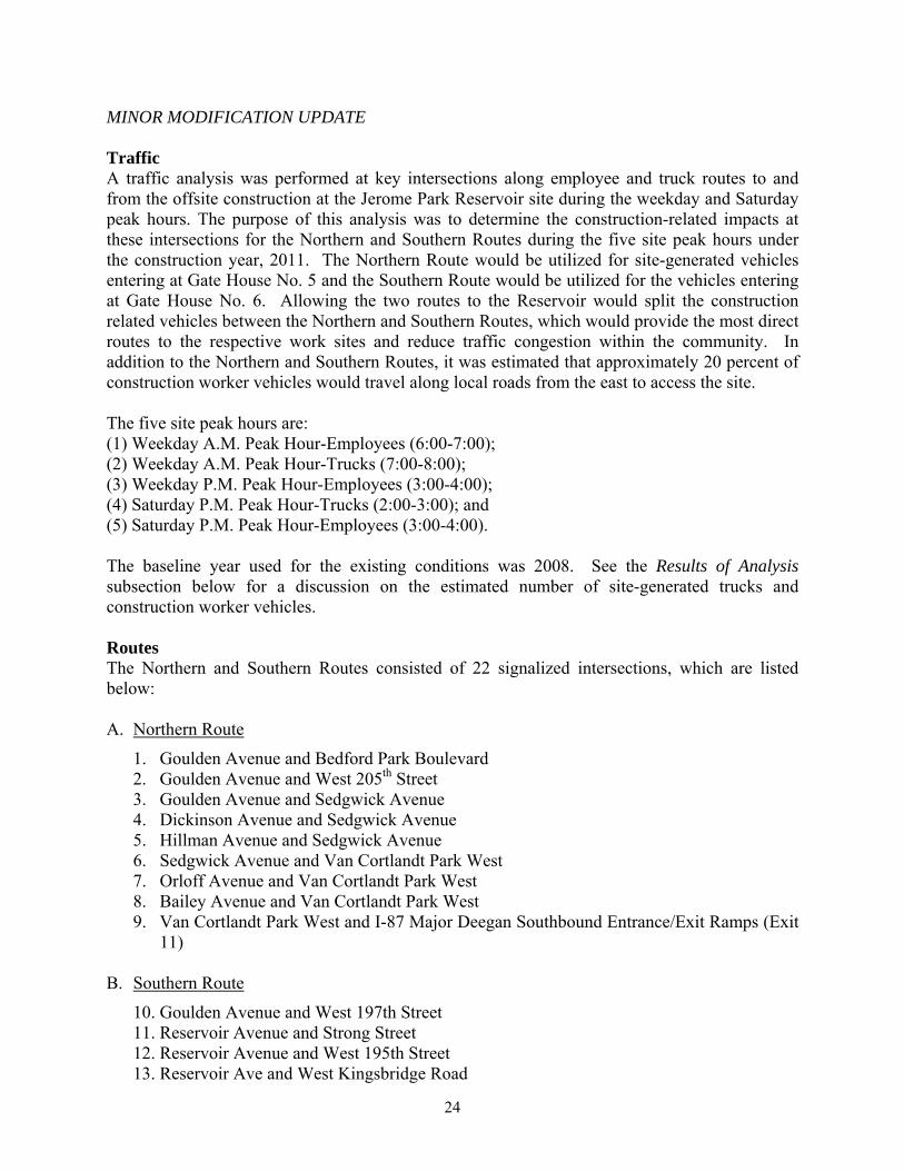
MINOR MODIFICATION UPDATE Traffic A traffic analysis was performed at key intersections along employee and truck routes to and from the offsite construction at the Jerome Park Reservoir site during the weekday and Saturday peak hours. The purpose of this analysis was to determine the construction-related impacts at these intersections for the Northern and Southern Routes during the five site peak hours under the construction year, 2011. The Northern Route would be utilized for site-generated vehicles entering at Gate House No. 5 and the Southern Route would be utilized for the vehicles entering at Gate House No. 6. Allowing the two routes to the Reservoir would split the construction related vehicles between the Northern and Southern Routes, which would provide the most direct routes to the respective work sites and reduce traffic congestion within the community. In addition to the Northern and Southern Routes, it was estimated that approximately 20 percent of construction worker vehicles would travel along local roads from the east to access the site. The five site peak hours are: (1) Weekday A.M. Peak Hour-Employees (6:00-7:00); (2) Weekday A.M. Peak Hour-Trucks (7:00-8:00); (3) Weekday P.M. Peak Hour-Employees (3:00-4:00); (4) Saturday P.M. Peak Hour-Trucks (2:00-3:00); and (5) Saturday P.M. Peak Hour-Employees (3:00-4:00). The baseline year used for the existing conditions was 2008. See the Results of Analysis subsection below for a discussion on the estimated number of site-generated trucks and construction worker vehicles. Routes The Northern and Southern Routes consisted of 22 signalized intersections, which are listed below: A. Northern Route
1. Goulden Avenue and Bedford Park Boulevard 2. Goulden Avenue and West 205th Street 3. Goulden Avenue and Sedgwick Avenue 4. Dickinson Avenue and Sedgwick Avenue 5. Hillman Avenue and Sedgwick Avenue 6. Sedgwick Avenue and Van Cortlandt Park West 7. Orloff Avenue and Van Cortlandt Park West 8. Bailey Avenue and Van Cortlandt Park West 9. Van Cortlandt Park West and I-87 Major Deegan Southbound Entrance/Exit Ramps (Exit
11)
B. Southern Route
10. Goulden Avenue and West 197th Street 11. Reservoir Avenue and Strong Street 12. Reservoir Avenue and West 195th Street 13. Reservoir Ave and West Kingsbridge Road
25
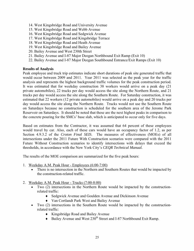
14. West Kingsbridge Road and University Avenue 15. West Kingsbridge Road and Webb Avenue 16. West Kingsbridge Road and Sedgwick Avenue 17. West Kingsbridge Road and Kingsbridge Terrace 18. West Kingsbridge Road and Heath Avenue 19. West Kingsbridge Road and Bailey Avenue 20. Bailey Avenue and West 230th Street 21. Bailey Avenue and I-87 Major Deegan Northbound Exit Ramp (Exit 10) 22. Bailey Avenue and I-87 Major Deegan Southbound Entrance/Exit Ramps (Exit 10)
Results of Analysis Peak employee and truck trip estimates indicate short durations of peak site generated traffic that would occur between 2009 and 2011. Year 2011 was selected as the peak year for the traffic analysis and represents the highest background traffic volumes for the peak construction period. It was estimated that for weekday construction 38 workers would arrive on a peak day (21 private automobiles), 22 trucks per day would access the site along the Northern Route, and 21 trucks per day would access the site along the Southern Route. For Saturday construction, it was estimated that 22 workers (12 private automobiles) would arrive on a peak day and 20 trucks per day would access the site along the Northern Route. Trucks would not use the Southern Route on Saturdays because no construction is scheduled for the southern area of the Jerome Park Reservoir on Saturdays. It should be noted that these are the next highest peaks in comparison to the concrete pouring for the SMCs’ base slab, which is anticipated to occur only for five days. Based on estimates from the Contractor, it was assumed that 64 percent of these employees would travel by car. Also, each of these cars would have an occupancy factor of 1.2, as per Section 4.9.3.2 of the Croton Final SEIS. The measures of effectiveness (MOEs) of all intersections under the 2011 Future With Construction scenarios were compared with the 2011 Future Without Construction scenarios to identify intersections with delays that exceed the thresholds, in accordance with the New York City’s CEQR Technical Manual. The results of the MOE comparison are summarized for the five peak hours: 1. Weekday A.M. Peak Hour - Employees (6:00-7:00)
There is no intersection in the Northern and Southern Routes that would be impacted by the construction-related traffic.
2. Weekday A.M. Peak Hour - Trucks (7:00-8:00)
Two (2) intersections in the Northern Route would be impacted by the construction-related traffic:
Sedgwick Avenue and Goulden Avenue and Dickinson Avenue Van Cortlandt Park West and Bailey Avenue
Two (2) intersections in the Southern Route would be impacted by the construction-related traffic:
Kingsbridge Road and Bailey Avenue Bailey Avenue and West 230th Street and I-87 Northbound Exit Ramp.

26
3. Weekday P.M. Peak Hour - Employees (3:00-4:00) One (1) intersection in the Northern Route would be impacted by the construction-
related traffic: Sedgwick Avenue and Goulden Avenue and Dickinson Avenue One (1) intersection in the Southern Route would be impacted by the construction-
related traffic: Bailey Avenue and West 230th Street and I-87 Northbound Exit Ramp
4. Saturday P.M. Peak Hour - Trucks (2:00-3:00) Two (2) intersections in the Northern Route would be impacted by the construction-
related traffic: Sedgwick Avenue and Goulden Avenue and Dickinson Avenue Van Cortlandt Park West and Bailey Avenue
No trucks would use the Southern Route. Therefore, the construction-related impacts are negligible.
5. Saturday P.M. Peak Hour - Employees (3:00-4:00)
There is no intersection in the Northern Route that would be impacted by the construction-related traffic.
One (1) intersection in the Southern Route would be impacted by the construction-related traffic: Bailey Avenue and West 230th Street and I-87 Northbound Exit Ramp.
Table 3 depicts the list of intersections and the peak hours that require improvement measures.
TABLE 3. INTERSECTIONS REQUIRING IMPROVEMENT MEASURES
Intersection Peak Hour NORTHERN ROUTE
Sedgwick Avenue/Goulden Avenue/Dickinson
Avenue
Weekday A.M.(7:00-8:00) Weekday P.M.(3:00-4:00) Saturday P.M.(2:00-3:00)
Van Cortlandt Park West/Bailey Avenue
Weekday A.M.(7:00-8:00) Saturday P.M.(2:00-3:00)
SOUTHERN ROUTE Kingsbridge Road/Bailey Avenue Weekday A.M.(7:00-8:00)
Bailey Avenue/West 230th Street/I-87 Northbound
Exit Ramp
Weekday A.M.(7:00-8:00) Weekday P.M.(3:00-4:00) Saturday P.M.(3:00-4:00)
Improvement measures were developed for the aforementioned intersections under the 2011 Future With Construction scenario to minimize delays. It should be noted that there would be short-term closures less than two months in duration of one lane at a time on Goulden Avenue adjacent to the SMC and less than two months in duration adjacent to Gate House No. 7, while construction would take place beneath the street. (Under the previous design lane closures on Goulden Avenue would have been for approximately 5 - 8 months in duration.) This would be temporary and would not be considered a potential significant adverse impact on local traffic.

27
Improvement Measures To minimize the delays at the four (4) affected signalized intersections, the existing signal timings of each intersection would need to be adjusted to avoid the adverse effects of construction when compared with the Future Without Construction conditions. The recommended signal timing adjustments for the four (4) intersections are indicated in Tables 4 to 9. It should be noted that each of the tables depicts the time period recommended for implementing the new timing plan. With the implementation of the recommended signal timings no significant adverse impact would occur to local traffic due to the proposed work at Jerome Park Reservoir. It should be noted that in order to implement three of the recommended signal timing adjustments new equipment will be installed (Bailey Avenue/Van Cortlandt Park West/I-87 NB Exit Ramp, Bailey Avenue/West 230th Street/I-87 NB Exit Ramp, and Kingsbridge Road/Bailey Avenue), providing an additional benefit to the Bronx traffic control system. These recommended signal timing adjustments, since they are proposed to be set permanently, would improve the existing traffic network in the project area and would provide long-term benefit to the community.
As shown in Table 4, the signal timings at the Sedgwick Avenue/Goulden Avenue/Dickinson Avenue intersection were adjusted during the weekday A.M. peak hour (7:00-8:00) and Saturday peak hour (2:00-3:00) by removing one second from Phase 2 at Sedgwick Avenue (eastbound and westbound from Mosholu Parkway-South) and adding it to Phase 3 at Goulden Avenue (northbound).
TABLE 4. RECOMMENDED TIMINGS FOR SEDGWICK AVENUE/GOULDEN
AVENUE/DICKINSON AVENUE INTERSECTION6
WEEKDAY A.M. 6:30 – 9:00 and SATURDAY P.M. 1:30 – 3:30
Existing Recommended Cycle
Length 120 seconds 120 seconds
Phase 11 22 33 44 55 11 22 33 44 55 Green 14 28 17 8 30 14 27 18 8 30
Clearance 3 3 3 0 3 3 3 3 0 3 All-Red 3 3 3 0 2 3 3 3 0 2
1Phase 1: Sedgwick Avenue (EB/WB from Mosholu Parkway-North) 2Phase 2: Sedgwick Avenue (EB/WB from Mosholu Parkway-South) 3Phase 3: Goulden Avenue (NB) 4Phase 4: Pedestrian Crossing Sedgwick Avenue 5Phase 5: Dickinson Avenue (SB) 6Clearance interval (yellow and all-red timings) would be unchanged As shown in Table 5, the signal timings at the Sedgwick Avenue/Goulden Avenue/Dickinson Avenue intersection were adjusted during the weekday P.M. peak hour (3:00-4:00) by removing one second from Phase 5 at Dickinson Avenue (southbound) and adding it to Phase 3 at Goulden Avenue (northbound).
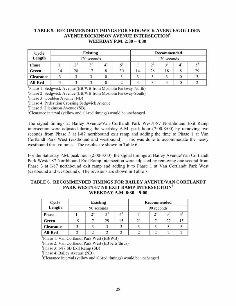
28
TABLE 5. RECOMMENDED TIMINGS FOR SEDGWICK AVENUE/GOULDEN AVENUE/DICKINSON AVENUE INTERSECTION6
WEEKDAY P.M. 2:30 – 4:30
Existing Recommended Cycle Length 120 seconds 120 seconds
Phase 11 22 33 44 55 11 22 33 44 55 Green 14 28 17 8 30 14 28 18 8 29 Clearance 3 3 3 0 3 3 3 3 0 3 All-Red 3 3 3 0 2 3 3 3 0 2
1Phase 1: Sedgwick Avenue (EB/WB from Mosholu Parkway-North) 2Phase 2: Sedgwick Avenue (EB/WB from Mosholu Parkway-South) 3Phase 3: Goulden Avenue (NB) 4Phase 4: Pedestrian Crossing Sedgwick Avenue 5Phase 5: Dickinson Avenue (SB) 6Clearance interval (yellow and all-red timings) would be unchanged The signal timings at Bailey Avenue/Van Cortlandt Park West/I-87 Northbound Exit Ramp intersection were adjusted during the weekday A.M. peak hour (7:00-8:00) by removing two seconds from Phase 3 at I-87 northbound exit ramp and adding the time to Phase 1 at Van Cortlandt Park West (eastbound and westbound). This was done to accommodate the heavy westbound thru volumes. The results are shown in Table 6. For the Saturday P.M. peak hour (2:00-3:00), the signal timings at Bailey Avenue/Van Cortlandt Park West/I-87 Northbound Exit Ramp intersection were adjusted by removing one second from Phase 3 at I-87 northbound exit ramp and adding it to Phase 1 at Van Cortlandt Park West (eastbound and westbound). The revisions are shown in Table 7.
TABLE 6. RECOMMENDED TIMINGS FOR BAILEY AVENUE/VAN CORTLANDT PARK WEST/I-87 NB EXIT RAMP INTERSECTION5
WEEKDAY A.M. 6:30 – 9:00
Existing Recommended Cycle Length 90 seconds 90 seconds
Phase 11 22 33 44 11 22 33 44
Green 19 7 29 15 21 7 27 15 Clearance 3 3 3 3 3 3 3 3
All-Red 2 2 2 2 2 2 2 2 1Phase 1: Van Cortlandt Park West (EB/WB) 2Phase 2: Van Cortlandt Park West (EB lefts/thrus) 3Phase 3: I-87 SB Exit Ramp (SB) 4Phase 4: Bailey Avenue (NB) 5Clearance interval (yellow and all-red timings) would be unchanged

29
TABLE 7. RECOMMENDED TIMINGS FOR BAILEY AVENUE/VAN CORTLANDT
PARK WEST/I-87 NB EXIT RAMP INTERSECTION5
SATURDAY P.M. 1:30 – 3:30
Existing Recommended Cycle Length 90 seconds 90 seconds
Phase 11 22 33 44 11 22 33 44 Green 19 7 29 15 20 7 28 15 Clearance 3 3 3 3 3 3 3 3
All-Red 2 2 2 2 2 2 2 2 1Phase 1: Van Cortlandt Park West (EB/WB) 2Phase 2: Van Cortlandt Park West (EB lefts/thrus) 3Phase 3: I-87 SB Exit Ramp (SB) 4Phase 4: Bailey Avenue (NB) 5Clearance interval (yellow and all-red timings) would be unchanged
In the Southern Route for the weekday A.M. peak hour (7:00 – 8:00), the signal timings at Kingsbridge Road/Bailey Avenue intersection were adjusted by removing one second from Phase 1 at Kingsbridge Road (eastbound and westbound) and adding it to Phase 2 at Bailey Avenue (northbound and southbound). The revisions are shown in Table 8.
For the Bailey Avenue/West 230th Street/I-87 NB Exit Ramp intersection, the current timings were adjusted for three peak hours: (1) weekday A.M. peak hour (7:00-8:00); (2) weekday P.M. peak hour (3:00-4:00); (3) Saturday P.M. peak hour (3:00-4:00). This was done by removing one second from Phase 1 at West 230th Street (eastbound) and adding it to Phase 3 at Bailey Avenue (northbound and southbound) to accommodate the heavy northbound left-turn volumes. The revisions are shown in Table 9.
TABLE 8. RECOMMENDED TIMINGS FOR KINGSBRIDGE ROAD/BAILEY AVENUE INTERSECTION3
WEEKDAY A.M. 6:30 – 9:00
Existing Recommended Cycle Length 120 seconds 120 seconds
Phase 11 22 11 22
Green 66 44 65 45 Clearance 3 3 3 3 All-Red 2 2 2 2
1Phase 1: Kingsbridge Road (EB/WB) 2Phase 2: Bailey Avenue (NB/SB) 3Clearance interval (yellow and all-red timings) would be unchanged

30
TABLE 9. RECOMMENDED TIMINGS FOR BAILEY AVENUE/WEST 230TH STREET/I-87 NB EXIT RAMP INTERSECTION4
WEEKDAY A.M. 6:30 – 9:00, WEEKDAY P.M. 2:30 – 4:30,
and SATURDAY P.M. 2:30 – 4:30
Existing Recommended Cycle Length 90 seconds 90 seconds
Phase 11 22 33 11 22 33 Green 26 24 25 25 24 26 Clearance 3 3 3 3 3 3
All-Red 2 2 2 2 2 2 1Phase 1: West 230th Street (EB) 2Phase 2: I-87 NB Exit Ramp (NB) 3Phase 3: Bailey Avenue (NB/SB) 4Clearance interval (yellow and all-red timings) would be unchanged
Parking NYCDEP is planning to provide off-street parking for the construction workers to reduce the parking demand on the community. The proposed off-street parking would be in the location of the Demonstration Water Treatment Plant. (The Demonstration Water Treatment Plant is slated for demolition under a separate project and would be completed prior to the peak parking demands anticipated for CRO-313 and CRO-312OS.) If the off-street parking proves to be insufficient, NYCDEP is seeking to obtain approval from New York City Department of Transportation (NYCDOT) and the City of New York Department of Sanitation (DSNY) to pursue changing the alternate side of the street parking restrictions on Goulden Avenue, which would eliminate midday parking restrictions during construction. In the event that these plans are ineffective, on-street parking on Goulden Avenue for the employee vehicles was evaluated. The on-street parking availability must accommodate 21 construction worker cars on a typical weekday and 12 cars on a Saturday. Parking inventories were conducted in September and October 2008 along Goulden Avenue while classes at the Bronx High School of Science were in session. These inventories documented existing parking restrictions and space utilization along the west and east sides of Goulden Avenue from Sedgwick Avenue to areas south of West 205th Street during the A.M., Midday, and P.M. peak hours for the weekdays and during the A.M. and early afternoon periods for the Saturday inventory. It was estimated that, excluding the spaces for driveways and fire hydrants along the curbside, the number of total parking spaces available along the west side of Goulden Avenue is approximately 104 car spaces and along the east side of Goulden Avenue is 97 car spaces. Currently, the general parking restrictions prohibit parking on the west side of Goulden Avenue from 11:30 A.M. to 1:00 P.M. on Mondays and Thursdays and on the east side from 11:30 A.M. to 1:00 P.M. on Tuesdays and Fridays. It should be noted that there are no parking restrictions south of Bedford Park Boulevard (on both sides of Goulden Avenue) where there are parking meters for six-hour parking.
31
During the weekday roadway A.M and P.M. peak periods (6:00 to 9:00 A.M and 4:00 to 7:00 P.M, respectively), there are no parking restrictions on both sides of Goulden Avenue. Therefore, there were excess parking spaces available. Field surveys indicated that there were generally 50 to 70 available parking spaces on both sides of Goulden Avenue during these periods. This available parking within the study limits also included the school buses parked on both sides of the local street. However, during the midday peak, parking restrictions essentially reduce the available parking to an average of approximately 18 empty spaces on the side of Goulden Avenue which has no parking restriction for that day. Field observations on a Saturday revealed a significant amount of available parking within the study area throughout the day, due to the fact that there are no parking restrictions on Saturdays. Given the current parking conditions, on-street parking along Goulden Avenue would be available to accommodate most of the 21 worker vehicles on weekdays and the 12 worker vehicles on Saturdays with no expected adverse impact to the community. The employees may also park at the parking meters south of Bedford Park Boulevard in the event that space would not be available for employee parking within the above-mentioned on-street parking limits. The project-generated parking demands are not anticipated to result in a significant impact. AIR QUALITY CONCLUSIONS FROM THE CROTON WTP FINAL SEIS The Final SEIS noted that the construction at Jerome Park Reservoir would result in the emission of air pollutants, principally from temporary construction equipment, such as a crane, backhoe/loader, and supply delivery trucks. As described in the Final SEIS, no significant adverse air quality impacts were anticipated in the area surrounding the Jerome Park Reservoir as a result of construction of the proposed facilities. The Final SEIS also concluded that project-related emissions of mobile source particulate matter (PM) less than 2.5 micron in aerodynamic diameter (PM2.5) emissions (i.e., construction traffic and equipment), would not result in significant adverse air quality impacts, given the extent of the construction activities. MINOR MODIFICATION UPDATE The proposed modification in the design and construction plans would require more construction equipment than originally discussed in the Final SEIS. The currently proposed construction activities would occur during staggered intervals over four years at a number of locations within the vicinity of Jerome Park Reservoir and generate air emissions from construction equipment exhaust, material transfer, fugitive dust, and potentially (if blasting is selected) from combustion by-products of explosives. This air quality assessment evaluates both the blasting scenario and the mechanical excavation scenario. The principle distinction between the two scenarios is that under the blasting scenario, blasting would add a new type of emission source (i.e., blasting charges) but the rock removal phase of the construction would require fewer pieces of construction equipment and be completed in less time.
This section details the anticipated air quality emissions associated with the proposed construction activities at the Jerome Park Reservoir site, ancillary to the WTP. Mobile air pollutant sources include engine exhaust emitted from vehicular traffic within the construction zone and off-road construction equipment such as loaders, excavators, and backhoes. On-road

32
mobile sources were evaluated and determined to fall below the mobile source screening thresholds4,5 thus, no additional analysis is necessary for these insignificant on-road mobile sources. Fugitive particulate (dust) sources include excavation activities, soil/rock handling and transfer, and re-suspension of road dust caused by on-site construction vehicle travel. The methodologies, as well as the pollutants of concern, the applicable air quality standards, and the potential impact criteria are presented in this section. The criteria air pollutants of concern include carbon monoxide (CO), PM2.5 and PM10, sulfur dioxide (SO2), nitrogen dioxide (NO2), ozone [O3, with volatile organic compounds (VOC) and nitrogen oxides (NOx) as precursors]. The analysis for each pollutant involved a two step process. First, the pollutant emission rates were estimated; then a dispersion model was run using the calculated emission rate for localized pollutants (i.e., CO, PM, NO2 in terms of NOx, and SO2 in terms of SOx). The emission rates predicted for O3 precursors are disclosed for informational purposes since they are of regional concern but are typically not addressed on a project basis. The two step analysis is described below. Emission Calculations The following on-site emission sources are considered in the impact analysis:
Trucks (haul and delivery) and construction equipment (loader, excavator, crane, etc. as applicable) diesel engine exhausts.
Surface dust resulting from the movement of trucks and construction equipment. Dust from material handling and blasting activities. Dust associated with drilling activities. Combustion by-products from explosives charges, if blasting scenario is selected.
Specific construction information used to calculate emissions generated from the construction process included the following:
Number and type of construction equipment to be used; Fuel type of construction equipment (all equipment assumed to be diesel-powered); Equipment usage (hours per day) rates; Equipment load (a percentage of the maximum horsepower) factors; Excavation and processing rates on a typical peak day; Average speed of all construction equipment and delivery vehicles; and, Average vehicles miles traveled on-site by diesel construction equipment.
The first step in the air quality analysis determined what the potential emission generating activities would be and when they would occur. Next, emission factors were applied to determine the specific emission rates (e.g., lbs/hr, lbs/day, and tons per year) of each activity.
4 City of New York CEQR Technical Manual, Chapter 3Q, §210 5 NYC Department of Environmental Protection Interim Guidance for PM2.5 Analyses, March 3, 2008

33
The number, type, and emission duration of construction equipment were based on the project’s estimated resource demands and the anticipated schedule of construction activities. A screening analysis was conducted to determine which construction year is anticipated to have the greatest activity (i.e., most pieces of equipment), as well as the highest potential emissions (e.g., exhaust, fugitive dust). The screening analysis showed that 2009 represented the peak construction year for air quality, with lower emissions anticipated in subsequent years. Inputs were generally limited to five days per week, with the exception of the soil excavation at the SMC where Saturday work is being evaluated; for this activity the input was six days per week. Emission factors (grams per brake-horsepower hour) relative to the combustion of fuel for on-site construction equipment (excluding delivery trucks/ heavy vehicles) for NOx, VOC, CO, PM10, PM2.5, and SOx were applied using site-specific United States Environmental Protection Agency (USEPA) certified tiered emission factors. Based on recent experience with other NYCDEP construction projects (e.g., CRO-311, 312, and 313), it is anticipated that the equipment would be USEPA Tier II, Tier III, or newer equipment. USEPA Tier engines reflect phased emission standards6 for new off-road compression-ignited (diesel) engines, with established maximum emissions for NOx, CO, and PM that mandate progressively cleaner engines be manufactured. Tier II engines were generally phased in (based on horsepower rating) between 2001 and 2004; Tier III engines began to be introduced in 2006. The emission rates for on-site delivery trucks/heavy vehicles for NOx, VOC, CO, and PM (SOx emissions were negligible because ultra low sulfur diesel is now in use) were obtained from the USEPA MOBILE6.2 Emission Model. Emission factors associated with fugitive dust emissions from mobile equipment were derived from equations presented in USEPA’s AP-42 “A Compilation of Air Pollution Emission Factors.” The geometry of the work sites, including tight turning radii, would restrict the traveling speeds of all on-site vehicles. The on-site speeds are anticipated to be slower than 5 miles per hour (mph); these low travel speeds are reflected in the calculation of the emissions. Load factors are also applied to the construction equipment. The load factor is the power level that an engine is operating relative to its rated capacity. Engines typically operate at a variety of speeds and loads, and operation at rated power for extended periods is rare. For example, at a 0.6 (or 60 percent) load factor, an engine rated at 100 horsepower (hp) would be producing an average of 60 hp over the course of normal operation. Load factors were assigned to construction equipment using guidance provided by the USEPA, Median Life, Annual Activity, and Load Factor Values for Nonroad Engine Emissions Modeling (April 2004). Additionally, an engine usage factor was applied, recognizing that certain pieces of equipment are not used continuously over the course of an 8-hour construction day. For example, a bulldozer may be present on-site, but is anticipated to be operational (engine running) for 40 percent of the construction day. The engine usage factors applied for the Air Quality analysis are the same as applied for the Noise analysis, and are provided in the New York City Noise Control Code (Chapter 28, §28-109 Appendix).
6 Title 40, CFR, Part 89.112 and Title 40, CFR, Part 1039.101

34
Under the blasting scenario, emissions of NOx, CO, and PM from blasting were estimated based on the anticipated quantity of explosives and emission factors from AP-42, specific to the proposed blasting material (ammonium nitrate with fuel oil, commonly referred to as ANFO). Emissions (engine exhaust and fugitive dust) were estimated for each of the construction areas for the peak period of each key emission source (e.g., peak soil removal and peak rock removal). Not all of the primary construction activities would occur at every site or occur concurrently; e.g., the soil overburden must be removed before rock removal can begin at a given site; soil and rock removal would not occur on the same day. For total annual emission estimates, all activities scheduled to occur within the peak year (i.e., 2009) were included in the calculation. For short term (hourly, daily) emission calculations, all activities scheduled to occur within the peak year were included with the exception of select activities which would not reasonably occur at the same time. In circumstances where two activities would not occur on the same day (e.g., noise barrier installation would be finished prior to soil/rock excavation for the SMC), the activity with the higher potential emissions was included in the emission calculation. In this manner, the overall reasonable worst-case emissions were determined for three intervals (hourly, daily, and annually). Emission Control Strategies On December 22, 2003, New York City adopted Local Law 77, which mandated the use of Ultra Low Sulfur Diesel fuel (ULSD) and Best Available Technology (BAT) by non-road vehicles in city construction. This law has two main parts. First, it requires that all diesel engines greater than 50 hp used on City construction projects operate on ULSD with sulfur content no greater than 15 parts per million (ppm). Second, it requires that these same diesel engines incorporate BAT to reduce emissions. The law applies to “any diesel-powered non-road vehicle that is owned by, operated by or on behalf of, or leased by a City agency”. These requirements were phased in, starting in lower Manhattan in June 2004 and expanded to include the entire city of New York by December 2004. Also note that cleaner burning fuels, more efficient and cleaner burning engines, and more after-market diesel PM retrofits, which were not available during the Final SEIS analysis, are incorporated into the emission control strategies. This project would employ the emissions-reducing technologies identified in Local Law 77 including the use of ULSD and BAT. All diesel construction vehicles on-site would be powered by ULSD, having a sulfur content of 15 ppm or less. Compared to “standard” grade diesel used as recently as five years ago, and having a sulfur content of 2,000 ppm, the conversion to ULSD helps achieve over a 90 percent reduction in sulfur dioxide (SO2) emissions. Any equipment on-site for more than 20 calendar days having a diesel engine rated over 50 hp would have BAT emission control devices installed on its exhaust. Where practicable, Diesel Particular Filters (DPF), with PM reductions of at least 85 percent, would be installed on the construction equipment to be used at the Jerome Park Reservoir site, and the construction equipment are anticipated to have USEPA certified Tier II, III, or higher engines. The project would comply with the New York City anti-idling regulations (NYC Code § 24-163), which generally limits idling of heavy duty diesel vehicles to three consecutive minutes. Where feasible, the project would extend the anti-idling prohibition to include all delivery trucks, as well as other diesel-powered (mobile-source) equipment. Recognizing that some mobile equipment such as concrete delivery trucks are exempted from the anti-idling prohibition due to their inherent function/need to accomplish a task (e.g., maintain spinning of a concrete drum to keep the concrete fluid prior to placement), NYCDEP would require all concrete trucks used on

35
this project to be equipped with EPA certified year 2007 (or newer) engines or active diesel particulate filters (ADPF). In the event this is not feasible, NYCDEP would require implementation of diesel oxidation catalysts (DOCs) and closed crankcase ventilators (CCVs) or particulate matter reduction technology equivalent to, or superior to, DOCs on all concrete trucks. Fugitive dust emissions reductions would be achieved through the implementation of best management practices. The Contractor would be responsible for controlling visible dust caused by work operations and the moving of vehicles and equipment. Dust control would be implemented when soils are exposed, before, during and after work activity ceases (including weekends). The Contractor would apply water or employ other dust control methods, subject to the engineer’s approval, when visible dust is present on-site. Drill rigs are anticipated to be equipped with sprays to suppress dust during drilling. The use of chemicals for dust control, including calcium chloride, would not be permitted. The beds of any trucks removing soil, rock, or material from the site will be covered with tarpaulins, and soil/sediment will be removed from vehicle tires prior to equipment leaving the work site. Emission Estimates Table 10 summarizes the emission estimates for the construction activities and provides a comparison between the blasting and mechanical scenarios. The mechanical scenario requires more equipment (i.e., air compressors, hoe-rams, and rock drills) than the blasting scenario. Additionally, non-blast related construction equipment is anticipated to operate more during the construction day if rock removal is accomplished by mechanical means alone; i.e., under the proposed blasting method, specific construction equipment are used intermittently (for breaking rock loosened by explosives into smaller pieces). While the blasting scenario does introduce a new emission source type (combustion by-products of explosive), the volume and concentration of these “new” emissions are less than the collective reduction in emissions that would be gained by the ability to use less equipment for shorter periods of time. Thus, the calculated cumulative annual emissions from the scenario which incorporates blasting are anticipated to be lower than the scenario which relies solely on mechanical means for rock removal.
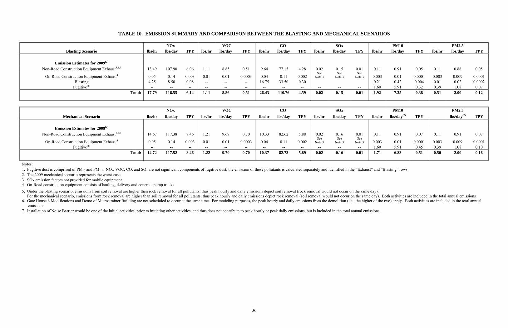
36
TABLE 10. EMISSION SUMMARY AND COMPARISON BETWEEN THE BLASTING AND MECHANICAL SCENARIOS
NOx VOC CO SOx PM10 PM2.5 Blasting Scenario lbs/hr lbs/day TPY lbs/hr lbs/day TPY lbs/hr lbs/day TPY lbs/hr lbs/day TPY lbs/hr lbs/day TPY lbs/hr lbs/day TPY
Emission Estimates for 2009(2)
Non-Road Construction Equipment Exhaust5,6,7 13.49 107.90 6.06 1.11 8.85 0.51 9.64 77.15 4.28 0.02 0.15 0.01 0.11 0.91 0.05 0.11 0.88 0.05
On-Road Construction Equipment Exhaust4 0.05 0.14 0.003 0.01 0.01 0.0003 0.04 0.11 0.002 See
Note 3 See
Note 3 See
Note 3 0.003 0.01 0.0001 0.003 0.009 0.0001 Blasting 4.25 8.50 0.08 -- -- -- 16.75 33.50 0.30 0.21 0.42 0.004 0.01 0.02 0.0002
Fugitive(1) -- -- -- -- -- -- -- -- -- -- -- -- 1.60 5.91 0.32 0.39 1.08 0.07 Total: 17.79 116.55 6.14 1.11 8.86 0.51 26.43 110.76 4.59 0.02 0.15 0.01 1.92 7.25 0.38 0.51 2.00 0.12
NOx VOC CO SOx PM10 PM2.5
Mechanical Scenario lbs/hr lbs/day TPY lbs/hr lbs/day TPY lbs/hr lbs/day TPY lbs/hr lbs/day TPY lbs/hr lbs/day(2) TPY lbs/day(2) TPY
Emission Estimates for 2009(2)
Non-Road Construction Equipment Exhaust5,6,7 14.67 117.38 8.46 1.21 9.69 0.70 10.33 82.62 5.88 0.02 0.16 0.01 0.11 0.91 0.07 0.11 0.91 0.07
On-Road Construction Equipment Exhaust4 0.05 0.14 0.003 0.01 0.01 0.0003 0.04 0.11 0.002 See
Note 3 See
Note 3 See
Note 3 0.003 0.01 0.0001 0.003 0.009 0.0001 Fugitive(1) -- -- -- -- -- -- -- -- -- -- -- -- 1.60 5.91 0.45 0.39 1.08 0.10
Total: 14.72 117.52 8.46 1.22 9.70 0.70 10.37 82.73 5.89 0.02 0.16 0.01 1.71 6.83 0.51 0.50 2.00 0.16
N otes: 1. Fugitive dust is comprised of PM10 and PM2.5. NOx, VOC, CO, and SOx are not significant components of fugitive dust; the emission of these pollutants is calculated separately and identified in the “Exhaust” and “Blasting” rows. 2. The 2009 mechanical scenario represents the worst-case. 3. SOx emission factors not provided for mobile equipment. 4. On-Road construction equipment consists of hauling, delivery and concrete pump trucks.
5. Under the blasting scenario, emissions from soil removal are higher then rock removal for all pollutants; thus peak hourly and daily emissions depict soil removal (rock removal would not occur on the same day). For the mechanical scenario, emissions from rock removal are higher than soil removal for all pollutants; thus peak hourly and daily emissions depict rock removal (soil removal would not occur on the same day). Both activities are included in the total annual emissions 6. Gate House 6 Modifications and Demo of Microstrainer Building are not scheduled to occur at the same time. For modeling purposes, the peak hourly and daily emissions from the demolition (i.e., the higher of the two) apply. Both activities are included in the total annual
emissions 7. Installation of Noise Barrier would be one of the initial activities, prior to initiating other activities, and thus does not contribute to peak hourly or peak daily emissions, but is included in the total annual emissions.

37
Dispersion Modeling Atmospheric dispersion modeling was conducted to calculate air quality effects from construction activities at off-site receptors, applying the USEPA refined dispersion model, AERMOD. AERMOD is a steady-state plume model that incorporates air dispersion based on planetary boundary layer turbulence structure and scaling concepts, including treatment of both surface and elevated sources, and both simple and complex terrain. Off-site receptors were designated at the fenceline, on the sidewalk (if present) surrounding the Reservoir, and at discrete receptors such as schools, playgrounds, and residences within close proximity to the proposed construction activities. The emissions from the peak year reasonable worst case construction activities (shown in Table 10) were input to the AERMOD dispersion model, assuming construction emissions between the hours of 7:00 A.M. and 3:00 P.M., with no nighttime emissions. While some construction activities would occur below grade, the elevation of the emission sources was generally and conservatively assumed to be at grade. However, a 20-foot high noise barrier would circumscribe the SMC site. The emission source release height for the SMC site would correspond to the height of the barrier (i.e., 20-feet). Therefore, the model was run with each construction activity assigned as a ground level area source except for the SMC activities within the 20-foot enclosed noise barrier. Five year representative, hourly, sequential, pre-processed meteorological data for the period 2002 through 2006 were applied, utilizing data from LaGuardia Airport to characterize surface winds and the Brookhaven National Weather Service (NWS) station to characterize upper level air movements, to estimate concentrations for selected averaging times from one hour to one year. Three types of receptors were modeled: 1) ground-level receptors placed along the project perimeters (fenceline) and on the sidewalk, 2) discrete receptors on nearby sensitive uses, and 3) neighborhood scale receptor grid. Fenceline and sidewalk receptors were placed in the model at approximately 10-meter intervals for those immediately adjacent to individual construction sites and 25-meter intervals for the remainder. Discrete receptors were placed to correspond with the location of existing schools, playgrounds, and residential buildings. The neighborhood receptor grid is a ground-level one square kilometer area with a uniform grid spacing of 25 meters. The grid is centered on the receptor where the maximum annual effect would occur. Maximum effects from ground-level area sources typically are anticipated at the nearest receptors, with concentration attenuating with distance. Ground-level receptors were placed 1.5 meters above ground to represent the height of an average person. Elevated receptors were also depicted in the model to represent different floors in the multi-story educational buildings and residential apartment/condominium buildings. All NOx and SOx emission rates were conservatively assumed to be NO2 and SO2, respectively. The predicted microscale reasonable worst-case concentrations of NO2, SO2, CO, and PM10 contributed from on-site sources, plus the ambient background levels, obtained from the most
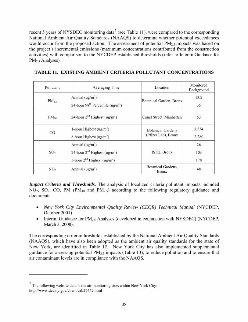
38
recent 5 years of NYSDEC monitoring data7 (see Table 11), were compared to the corresponding National Ambient Air Quality Standards (NAAQS) to determine whether potential exceedances would occur from the proposed action. The assessment of potential PM2.5 impacts was based on the project’s incremental emissions (maximum concentrations contributed from the construction activities) with comparison to the NYCDEP-established thresholds (refer to Interim Guidance for PM2.5 Analyses).
TABLE 11. EXISTING AMBIENT CRITERIA POLLUTANT CONCENTRATIONS
Pollutant Averaging Time Location Monitored
Background
Annual (ug/m3) 13.2 PM2.5
24-hour 98th Percentile (ug/m3) Botanical Garden, Bronx
35
PM10 24-hour 2nd Highest (ug/m3) Canal Street, Manhattan 53
1-hour Highest (ug/m3) 3,534 CO
8-hour Highest (ug/m3)
Botanical Gardens (Pfizer Lab), Bronx 2,280
Annual (ug/m3) 26
24-hour 2nd Highest (ug/m3) 103 SO2
3-hour 2nd Highest (ug/m3)
IS 52, Bronx
178
NO2 Annual (ug/m3) Botanical Gardens,
Bronx 48
Impact Criteria and Thresholds. The analysis of localized criteria pollutant impacts included NO2, SO2, CO, PM (PM10 and PM2.5) according to the following regulatory guidance and documents:
New York City Environmental Quality Review (CEQR) Technical Manual (NYCDEP, October 2001).
Interim Guidance for PM2.5 Analyses (developed in conjunction with NYSDEC) (NYCDEP, March 3, 2008).
The corresponding criteria/thresholds established by the National Ambient Air Quality Standards (NAAQS), which have also been adopted as the ambient air quality standards for the state of New York, are identified in Table 12. New York City has also implemented supplemental guidance for assessing potential PM2.5 impacts (Table 13), to reduce pollution and to ensure that air contaminant levels are in compliance with the NAAQS.
7 The following website details the air monitoring sites within New York City: http://www.dec.ny.gov/chemical/27442.html
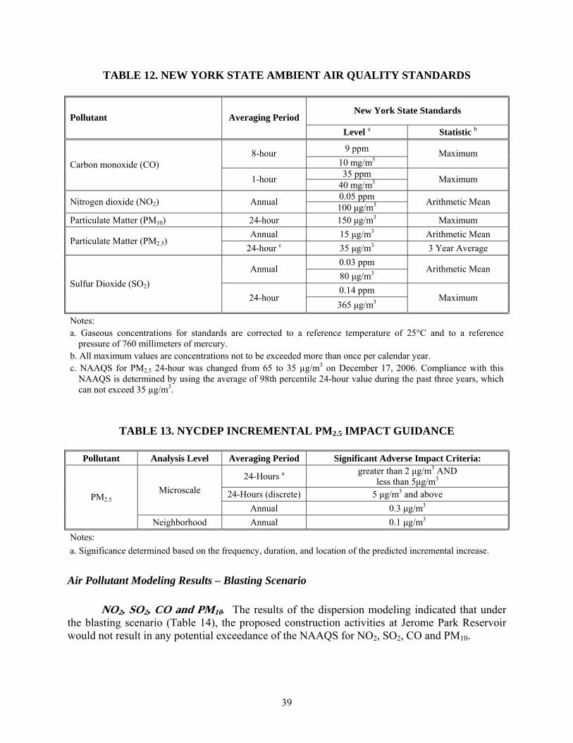
39
TABLE 12. NEW YORK STATE AMBIENT AIR QUALITY STANDARDS
New York State Standards Pollutant Averaging Period
Level a Statistic b
9 ppm 8-hour 10 mg/m3
Maximum
35 ppm Carbon monoxide (CO)
1-hour 40 mg/m3
Maximum
0.05 ppm Nitrogen dioxide (NO2) Annual
100 μg/m3 Arithmetic Mean
Particulate Matter (PM10) 24-hour 150 μg/m3 Maximum
Annual 15 μg/m3 Arithmetic Mean Particulate Matter (PM2.5)
24-hour c 35 μg/m3 3 Year Average
0.03 ppm Annual
80 μg/m3 Arithmetic Mean
0.14 ppm Sulfur Dioxide (SO2)
24-hour 365 μg/m3 Maximum
Notes: a. Gaseous concentrations for standards are corrected to a reference temperature of 25°C and to a reference
pressure of 760 millimeters of mercury. b. All maximum values are concentrations not to be exceeded more than once per calendar year. c. NAAQS for PM2.5 24-hour was changed from 65 to 35 µg/m3 on December 17, 2006. Compliance with this
NAAQS is determined by using the average of 98th percentile 24-hour value during the past three years, which can not exceed 35 µg/m3.
TABLE 13. NYCDEP INCREMENTAL PM2.5 IMPACT GUIDANCE
Pollutant Analysis Level Averaging Period Significant Adverse Impact Criteria:
24-Hours a greater than 2 μg/m3 AND
less than 5μg/m3
24-Hours (discrete) 5 μg/m3 and above Microscale
Annual 0.3 μg/m3 PM2.5
Neighborhood Annual 0.1 μg/m3
Notes:
a. Significance determined based on the frequency, duration, and location of the predicted incremental increase.
Air Pollutant Modeling Results – Blasting Scenario
NO2, SO2, CO and PM10. The results of the dispersion modeling indicated that under the blasting scenario (Table 14), the proposed construction activities at Jerome Park Reservoir would not result in any potential exceedance of the NAAQS for NO2, SO2, CO and PM10.

40
TABLE 14. PREDICTED CRITERIA POLLUTANT CONCENTRATIONS (BLASTING SCENARIO)
Averaging Time Monitored BackgroundConstruction Contributions
Total NAAQS
PM10 24-hour 2nd Highest (μg/m3) 53 a 11.6 65 150
CO
8-hour Highest (μg/m3) 2,280 b 746.2 3,026 10,000 1-hour Highest (μg/m3) 3,534 b 2,780.7 6,315 40,000
SO2
Annual (μg/m3) 26 c 0.007 26 80 24-hour 2nd Highest (μg/m3) 103 c 0.49 104 365 3-hour 2nd Highest (μg/m3) 178 c 2.6 181 1,300
NO2
Annual (μg/m3) 48 a 5.6 54 100 a: Canal Street, Manhattan b: Botanical Gardens (Pfizer Lab), Bronx c: IS 52, Bronx
PM2.5.As shown in Table 15, the proposed construction would not result in a PM2.5
increment exceeding the 24-hour 5 μg/m3 threshold under the blasting scenario. Additionally, none of the receptors representing schools and residences are anticipated to exceed the 24-hour 2 μg/m3 threshold. However, some of the fenceline and sidewalk receptors located adjacent to the proposed construction sites have the potential to exceed 2 μg/m3 over a 24-hour period. These receptors are limited to those in the vicinity of the SMC noise barrier and next to Gate House No. 6 / Microstrainer Building. The project’s annual construction emission increments at all modeled receptors are below the 0.3 μg/m3 threshold, and the neighborhood scale annual effects are well below the 0.1 μg/m3 threshold. Since there is the potential for the 24-hour period concentrations to exceed the 2 μg/m3 threshold, the frequency, duration, and location of the receptors where the threshold may be exceeded were examined further. For the SMC construction site, the model predicted that at one receptor, the construction emissions would exceed 2 μg/m3 for a maximum of four times a year, with the highest 24-hour PM2.5 increment of 2.96 μg/m3. This receptor is located at a corner formed by the noise barrier on the north side of the SMC site and the fence around the Reservoir, approximately 50 feet from the sidewalk. The next highest affected receptor is located on the sidewalk across from the SMC site. The predicted concentration from the proposed construction at this receptor would exceed 2 μg/m3 for a maximum of two times a year, with the highest 24-hour PM2.5 increment of 2.6 μg/m3. None of the project’s construction emission increments would exceed 2 μg/m3 at the schools, playground, or residences. For the Gate House No.6/Microstrainer Building construction site, only two of the five modeled years show concentrations above the 2 μg/m3 threshold. The model predicted that the maximum number of times the 2 μg/m3 threshold would be exceeded is twice in a year, with the maximum concentration of 2.3 μg/m3, and they are limited to sidewalk and fenceline receptors.

41
TABLE 15. PREDICTED MICROSCALE MAXIMUM PM2.5 INCREMENTAL CONCENTRATIONS (BLASTING SCENARIO)
Averaging Time Proposed Incremental Level Interim Guidance Criteria
Fenceline
Annual (μg/m3) 0.055 0.3
24-hour Highest (μg/m3) 2.96 2 and 5 Sidewalk
Annual (μg/m3) 0.102 0.3
24-hour Highest (μg/m3) 2.52 2 and 5 Residential Places/Schools
Annual (μg/m3) 0.046 0.3
24-hour Highest (μg/m3) 1.80 2 and 5
Neighborhood Scale Impacts
Annual (μg/m3) 0.0046 0.1
Air Pollutant Modeling Results – Mechanical Scenario
NO2, SO2, CO and PM10. The results of the dispersion modeling indicated that under the mechanical scenario (Table 16), the proposed construction activities at Jerome Park Reservoir would not result in any potential exceedances of the NAAQS for NO2, SO2, CO or PM10. The construction emission effects under the mechanical scenario are slightly different from the blasting scenario. The short term emissions of CO and PM10 are lower because there would not be any CO or PM10 emissions associated with blasting. However, the emissions of NO2 and SO2 are higher due to additional equipment usage and longer construction period for rock excavation.
PM2.5. As shown in Table 17, the proposed construction would not result in a PM2.5 increment exceeding the 24-hour 5 μg/m3 threshold under the mechanical scenario. Additionally, none of the receptors representing schools, playground, or residences are anticipated to exceed the 24-hour 2 μg/m3 threshold. However, some of the fenceline and sidewalk receptors located adjacent to the proposed construction sites have the potential to exceed 2 μg/m3 over a 24-hour period. These receptors are limited to those in the vicinity of the SMC noise barrier and next to the Gate House No. 6 / Microstrainer Building construction site. The annual construction emission increments at all modeled receptors are well below the 0.3 μg/m3 threshold, and the neighborhood scale annual effects are well below the 0.1 μg/m3 threshold.

42
TABLE 16. PREDICTED CRITERIA POLLUTANT CONCENTRATIONS (MECHANICAL SCENARIO)
Averaging Time Monitored BackgroundConstruction Contributions
Total NAAQS
PM10 24-hour 2nd Highest (μg/m3) 53 a 9.8 63 150
CO
8-hour Highest (μg/m3) 2,280 b 540.6 2,821 10,000 1-hour Highest (μg/m3) 3,534 b 1,820.1 5,354 40,000
SO2
Annual (μg/m3) 26 c 0.008 26 80 24-hour 2nd Highest (μg/m3) 103 c 0.77 104 365 3-hour 2nd Highest (μg/m3) 178 c 3.0 181 1,300
NO2
Annual (μg/m3) 48 a 5.7 54 100 a: Canal Street, Manhattan b: Botanical Gardens (Pfizer Lab), Bronx c: IS 52, Bronx
TABLE 17. PREDICTED MICROSCALE MAXIMUM PM2.5 INCREMENTAL
CONCENTRATIONS (MECHANICAL SCENARIO)
Averaging Time
Proposed Incremental Level
Interim Guidance Criteria
Fenceline
Annual (μg/m3) 0.071 0.3
24-hour Highest (μg/m3) 2.74 2 and 5
Sidewalk
Annual (μg/m3) 0.135 0.3
24-hour Highest (μg/m3) 2.35 2 and 5
Residential Places/Schools
Annual (μg/m3) 0.067 0.3
24-hour Highest (μg/m3) 1.67 2 and 5
Neighborhood Scale Impacts
Annual (μg/m3) 0.0062 0.1
Since there is the potential for the 24-hour period concentrations to exceed the 2 μg/m3 threshold, the frequency, duration, and location of the receptors where the threshold may be exceeded were examined further. For the SMC site, the model predicted that at one receptor, the construction emissions increment would exceed 2 μg/m3 for a maximum of three times a year, and have a highest 24-hour PM2.5 increment of 2.74 μg/m3. This receptor is the same one discussed under the blasting scenario, and is located at a corner formed by the noise barrier on the north side of the SMC site and the fence of the Reservoir, approximately 50 feet from the sidewalk. The next highest affected receptor is located on the sidewalk adjacent to the SMC site. The predicted

43
concentration from the proposed construction at this receptor would exceed 2 μg/m3 for a maximum of two times a year, with the highest 24-hour PM2.5 increment of 2.4 μg/m3. None of the project’s construction emission increments would exceed 2 μg/m3 at the schools, playground, or residences. The 24-hour construction effects from the mechanical scenario are slightly lower than those for the blasting scenario since the mechanical scenario does not have the emissions associated with blasting. For the Gate House No. 6/Microstrainer Building, only two of the five modeled years show concentrations above the 2 μg/m3 threshold. The model predicted that the maximum number of times the 2 μg/m3 threshold would be exceeded is twice in a year, with the maximum concentration of 2.3 μg/m3, and these exceedances are limited to sidewalk and fenceline receptors. At these locations, the construction emissions from the mechanical scenario are almost identical to those of the blasting scenario, because the SMC site (and its potential blasting) is too distant to have a material effect at receptors near Gate House No. 6 / Microstrainer Building. CONCLUSION The current modification would require a greater number of construction equipment than anticipated during preparation of the Final SEIS; whereas the use of new diesel equipment (Tier II or newer) and aftermarket pollution controls would reduce emissions substantially. These changes have been reflected in the air emissions analyses conducted for both the blasting and the mechanical scenarios. For both construction scenarios, the modeling results showed that the proposed construction activities would not result in exceedances of NAAQS for NO2, SO2, CO, and PM10. The maximum annual impacts and the neighborhood scale annual impacts of PM2.5 emissions at all modeled receptors are below the significance thresholds. The proposed construction would not result in PM2.5 increment exceeding the 24-hour 5 μg/m3 threshold; none of the construction impacts on the schools, playgrounds, and residences would exceed 2 μg/m3. The potential for the 24-hour period concentrations to exceed the 2 μg/m3 threshold is limited to the fenceline and sidewalk receptors adjacent to the construction sites. The frequency, duration and location of these impacts were examined in further detail. Under the blasting scenario, the 2 μg/m3 threshold was exceeded four times with the maximum concentration of 2.96 μg/m3. Under the mechanical scenario, the threshold was exceeded three times with the maximum concentration of 2.74 μg/m3. The mechanical scenario would result in lower 24-hour PM2.5, 1-hour and 8-hour CO impacts. However, additional equipment usage and longer construction period due to rock excavation would result in higher total emissions as reflected in higher annual concentrations. The concentrations for both scenarios would be very conservative estimates of the effects from the proposed actions. The emissions from the entire period of construction were examined and the peak emissions were modeled for five years, which means that the modeling results would be representative of the construction impacts if the peak emissions would last for the duration of the entire five years of construction. However, these peak emissions would not last for the entire construction period, i.e., the concrete work for the riser shafts is scheduled to be completed in three months, and the rock excavation of the

44
SMC is expected to last for three months under the blasting scenario or six months under the mechanical scenario, and the emissions of the non-peak periods would be substantially lower. Therefore, the maximum construction impact and the number of occurrences where the 2 μg/m3 threshold would actually be exceeded are expected to be much lower than the modeled results. Furthermore, the impacts at the fence line and sidewalk receptors are transient in nature; it is unlikely for a person to stay at these locations for a continuous 24-hour period. Based on the air quality analysis, the proposed modification in the project’s design, and construction methodology would not have a significant impact on air quality. NOISE CONCLUSIONS FROM THE CROTON WTP FINAL SEIS As discussed in the Final SEIS, potential noise effects due to mechanical rock removal were analyzed for stationary source sensitive receptors in the vicinity of the site. Peak construction noise levels were compared to noise levels for the Future Without the Project year. The year 2010 was used as the anticipated peak year for stationary source noise for construction activities. On the basis of the passenger car equivalence (PCE) screening analysis, it was determined that none of the identified noise-sensitive route segments in the vicinity of the site required further analysis of mobile source noise. Potential noise impacts resulting from the use of on-site equipment during construction activities were determined for three sensitive receptors proximate to the Jerome Park Reservoir. The receptors included: Bronx High School of Science, residences on Sedgwick Avenue, and Fort Independence Park. The maximum projected monthly noise level from construction activities was added to monitored baseline noise levels in order to determine the potential noise impacts at the various receptors as a result of the construction activity. Noise levels predicted to occur as a result of the mechanical rock removal during construction of the proposed project were anticipated to exceed the CEQR Technical Manual 3-5 dBA threshold used to evaluate impact at the Bronx High School of Science. These increased noise levels would be intermittent and would persist for less than eight months out of a year, and therefore were considered temporary and not significant. Although construction would not be continuous over this period, noise attenuation solutions were considered due to the sensitive nature of the Bronx High School of Science and other nearby sensitive receptors in the surrounding area. As recommended in the Final SEIS, a noise attenuating barrier was to be constructed to reduce the construction-generated noise to levels that are below than the 3-5 dBA CEQR Technical Manual threshold. MINOR MODIFICATION UPDATE Since the Final SEIS, plans were developed to construct a 20-foot high noise barrier to the north, east, and south of the SMC. In addition, a noise attenuation blanket is to be installed on the existing fence to the west of the SMC, adjacent the Jerome Park Reservoir perimeter wall. As a supplement to these noise attenuation systems, NYCDEP has established a monitoring program
45
and dedicated complaint response system to address any unforeseen construction-related noise impacts. Contracts CRO-313 and CRO-312OS are expected to proceed at a high level of activity beginning in 2009 through 2012. A noise assessment was conducted to evaluate the potential for adverse noise levels as a result of the design changes within the Jerome Park Reservoir study area. Noise associated with the construction equipment as well as noise from construction trucks were analyzed in accordance with the CEQR Technical Manual. The potential affects of blasting noise were also evaluated in accordance with Occupational Safety and Health Administration (OSHA) hearing conservation guidelines and other criteria intended to avoid window breakage. Noise analyses were performed for expected weekday work as well as for potential Saturday construction, if it is deemed necessary in the future. Stationary Construction Noise To assess the construction noise impacts from stationary equipment, the loudest projected hourly noise level in any given month due to construction activity was added to the monitored baseline noise levels in order to determine the worst-case potential noise impacts at the various receptor locations. Construction noise levels were evaluated at three sensitive receptors adjacent to the Reservoir: the Bronx High School of Science, residences on Sedgwick Avenue, and schools and residences along Goulden Ave and Reservoir Avenue. The results of the on-site construction noise analysis using the Federal Highway Administration (FHWA)-approved Roadway Construction Noise Model (RCNM) are summarized in Table 18 for the three receptor locations for both weekday and Saturday time periods. The reported results show the range of predicted worst-case Leq(h) noise levels in any given month over the project’s 50-month duration assuming all equipment to be operating simultaneously during all phases of work. A 10 to 15 decibel attenuation factor was used in the modeling for any work being performed behind the required noise barrier at the SMC and associated yard piping between the SMC and Gate House No. 5. If the emergency bypass alternative that requires connections to Gate House No. 5 is selected, the noise barrier would be extended approximately 40 feet south, parallel to Goulden Avenue, to surround the work. In addition, attenuation factors of up to 20 decibels were assumed in the noise model for the work tasks scheduled to occur inside the various Gate Houses. The results for weekday timeframes generally meet the CEQR Technical Manual construction noise guidelines except periodically under worst-case conditions during fifteen non-continuous months at the Bronx Science High School and during nine non-continuous months at the receptor location along Goulden and Reservoir Avenue based on excavation of rock being removed by mechanical means. Removal of rock by blasting would reduce these durations by approximately half the time required for mechanical rock removal. Noise levels at residences on Sedgwick Avenue are expected to be comparable to the future without the project assumptions throughout the project’s 50-month schedule. The results for Saturday timeframes are below applicable CEQR Technical Manual guidelines. The elevated noise levels shown among various construction phases are primarily attributable to a single noise source with the mechanical rock removal method (i.e., the extended use of an

46
impact pile driver or a hoe ram). These sources, by their nature and design, generate fairly constant highly impulsive noise during their intended operations. Although the blast noise associated with the blasting rock removal method would create a similarly high impulsive noise during the blast itself, the frequency of occurrences (one to two blasts per day) would be substantially less as compared to the mechanical rock removal method. In addition, in all areas where rock removal is required (i.e., SMC, associated yard piping, and South Basin Ramp), it is estimated that at least one additional rock drill and hoe ram would be required to break the rock under the mechanical rock removal option, as compared to the blasting rock removal option. Therefore, the blasting rock removal option would likely result in lower noise levels than presented above.
TABLE 18. ON-SITE CONSTRUCTION NOISE RESULTS
Receptor Description (exterior to structures)
Average Background
Leq Noise Level
CEQR Leq(h) Noise
Criteria Level
Predicted On-site Construction
Leq(h) Noise Level
Above or Below CEQR Level
Threshold
62 dBA (weekday)
65 dBA (weekday)
62 to 73 dBA (weekday)
Above during 15 non-
continuous months
Bronx High School of Science
59 dBA (Saturday)
64 dBA (Saturday)
59 to 63 dBA (Saturday)
Below
64 dBA (weekday)
67 dBA (weekday)
64 to 66 dBA (weekday)
Below Residences on Sedgwick Ave 62 dBA
(Saturday) 65 dBA
(Saturday) 62 to 62 dBA
(Saturday) Below
64 dBA (weekday)
67 dBA (weekday)
64 to 79 dBA (weekday)
Above during 9 non-
continuous months
Schools and Residences
along Goulden Ave and
Reservoir Ave 62 dBA (Saturday)
65 dBA (Saturday)
62 to 62 dBA (Saturday)
Below
The construction activity associated with the work around Jerome Park Reservoir would be a source of elevated noise levels. The predicted noise level changes would occur intermittently throughout the construction period depending on the construction activity. The community, especially the most sensitive receptors within the community, such as the schools, would find these noise levels disturbing and a nuisance. The increased noise levels would occur during day time hours and are not expected to adversely affect nighttime noise levels. Given the short duration and intermittent nature of the elevated noise levels and measures being taken to attenuate the construction-related noise, it is not anticipated that the proposed modifications to design and construction plans would result in a potential significant adverse noise impact to sensitive receptors in the vicinity of Jerome Park Reservoir. In addition, it should be noted that NYCDEP is working with Bronx High School of Science to install air conditioners in the windows of the classrooms facing Jerome Park Reservoir. With the

47
air conditioners the windows in these classrooms can remain closed during summer months when ordinarily they would be open. An USEPA study shows that the indoor noise levels with windows opened are typically 12 dBA lower than outdoor levels.8 With the windows closed, indoor noise levels are anticipated to be 20-25 dBA lower than outdoor levels. Hoe Ram Noise Versus Blasting Noise The potential noise consequences of blasting were analyzed at the three receptor locations using the RCNM model in the event blasting is used for excavation and yard piping at the SMC or for excavation at the South Basin Ramp area. Additional noise criteria were considered and additional analysis was performed in this study to evaluate the effects of the blast event itself for such things as potential hearing damage and window breakage. OSHA has promulgated regulations in 29 CFR Part 1910.95 which limits noise exposure for laborers not to exceed 115 dBA Lmax slow or 140 dB Peak for hearing conservation purposes. Also, sources such as the US Bureau of Mines, the US Army, and other industrial standards suggest that overpressures (i.e., noise) from explosions should not exceed 136 to 154 dB Peak (or an average of 145 dB Peak). The results of this additional analysis for blasting noise indicate that the noise due to the blast itself is expected to be below criteria limits for both hearing damage as well as window breakage at all the receptor locations. While the blast itself would likely be clearly audible to people outside the buildings, it would not pose a concern from a public health and/or structural damage perspective. People inside the buildings may also hear the blast noise. The blasting noise would occur quickly, infrequently and would be below overpressure levels that could cause hearing damage or damage to nearby structures. Therefore, no potential significant adverse noise impacts are anticipated as a result of the proposed blasting activities. The noise produced by a single hoe ram can be directly compared to the noise produced by a single blast if some assumptions are made in order to normalize their time intervals. According to the RCNM model, blasting has an emission noise level of 94 dBA Lmax at 50 feet but the event lasts for only a second or two. A hoe ram has a noise emission level of 90 dBA Lmax at 50 feet and a usage factor of 20 percent, which over the course of an hour would mean that the hoe ram is working at full noise output for 720 seconds. Therefore, when viewed as a “dose” of noise averaged over one hour, the Leq emission at 50 feet for the hoe ram would be 83 dBA, where blasting would only produce an hourly Leq of 58 dBA for a weighted one-hour average. Therefore, it is expected that under the blasting method option the potential impulsive noise impact to the neighborhood would be substantially less than under the mechanical method option. To further illustrate, if the noise contributions from just the blasting noise verses mechanical noise can be isolated, then a difference can be seen in predicted noise levels at the three receptor locations (Table 19). Keep in mind, however, that the following results do not account for the noise contribution from all the other job sites occurring around the Reservoir, and they have not
8 EPA, “Protective Noise Levels”, EPA 550/9-79-100, November 1979.
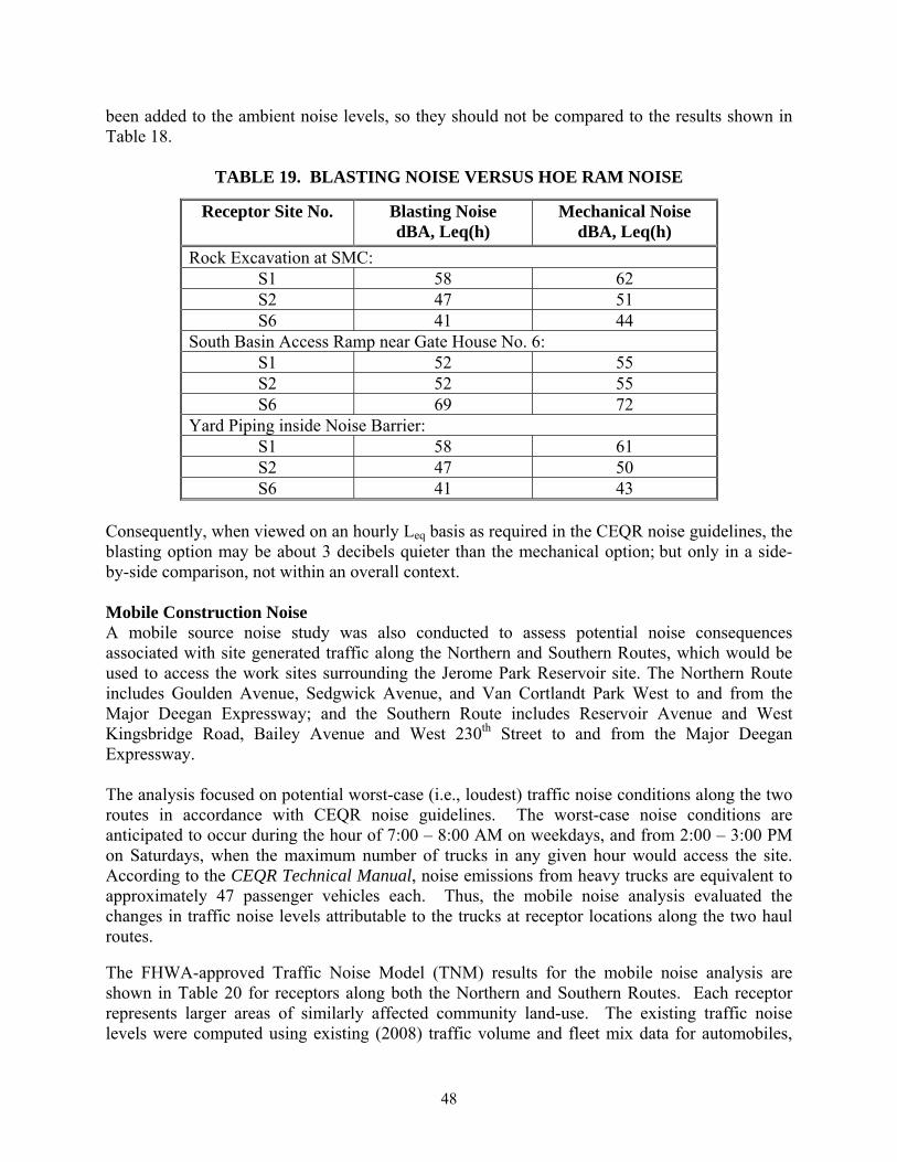
48
been added to the ambient noise levels, so they should not be compared to the results shown in Table 18.
TABLE 19. BLASTING NOISE VERSUS HOE RAM NOISE
Receptor Site No. Blasting Noise dBA, Leq(h)
Mechanical Noise dBA, Leq(h)
Rock Excavation at SMC: S1 58 62 S2 47 51 S6 41 44
South Basin Access Ramp near Gate House No. 6: S1 52 55 S2 52 55 S6 69 72
Yard Piping inside Noise Barrier: S1 58 61 S2 47 50 S6 41 43
Consequently, when viewed on an hourly Leq basis as required in the CEQR noise guidelines, the blasting option may be about 3 decibels quieter than the mechanical option; but only in a side-by-side comparison, not within an overall context. Mobile Construction Noise A mobile source noise study was also conducted to assess potential noise consequences associated with site generated traffic along the Northern and Southern Routes, which would be used to access the work sites surrounding the Jerome Park Reservoir site. The Northern Route includes Goulden Avenue, Sedgwick Avenue, and Van Cortlandt Park West to and from the Major Deegan Expressway; and the Southern Route includes Reservoir Avenue and West Kingsbridge Road, Bailey Avenue and West 230th Street to and from the Major Deegan Expressway. The analysis focused on potential worst-case (i.e., loudest) traffic noise conditions along the two routes in accordance with CEQR noise guidelines. The worst-case noise conditions are anticipated to occur during the hour of 7:00 – 8:00 AM on weekdays, and from 2:00 – 3:00 PM on Saturdays, when the maximum number of trucks in any given hour would access the site. According to the CEQR Technical Manual, noise emissions from heavy trucks are equivalent to approximately 47 passenger vehicles each. Thus, the mobile noise analysis evaluated the changes in traffic noise levels attributable to the trucks at receptor locations along the two haul routes. The FHWA-approved Traffic Noise Model (TNM) results for the mobile noise analysis are shown in Table 20 for receptors along both the Northern and Southern Routes. Each receptor represents larger areas of similarly affected community land-use. The existing traffic noise levels were computed using existing (2008) traffic volume and fleet mix data for automobiles,

49
medium trucks, heavy trucks and buses for the hours corresponding to peak trucking activities. Future noise levels were then predicted by adding the number of peak hour trucks associated with the project to the existing TNM model. Five heavy trucks were included along the Northern Route, and four heavy trucks were included along the Southern Route, during weekday time periods. On Saturdays, four heavy trucks were included along the Northern Route and none for the Southern Route. The results indicate an increase of no more than one decibel at any of the receptor locations along the Northern and Southern Routes. These results are within CEQR Technical Manual guidelines; therefore, no potential impacts from project-generated mobile source noise are anticipated.
TABLE 20. TNM MOBILE NOISE RESULTS
Site Receptor Description
Existing Traffic Noise
Leq(h)
Traffic Noise With Project
Trucks Leq(h)
CEQR Leq(h) Mobile Noise Level
Relative Increase
(*)
Above or Below CEQR Level
47 dBA (weekday)
48 dBA (weekday)
52 dBA 1 dBA Below
1 VA Medical Center
N. Kingsbridge Road Southern Route 46 dBA
(Saturday) 46 dBA
(Saturday) 51 dBA 0 dBA
Below
63 dBA (weekday)
63 dBA (weekday)
66 dBA 0 dBA Below
2
Residences on N. Kingsbridge Road
N. Kingsbridge Road Southern Route
62 dBA (Saturday)
62 dBA (Saturday)
65 dBA 0 dBA Below
60 dBA (weekday)
61 dBA (weekday)
65 dBA 1 dBA Below
3 Bronx Armory
Reservoir Avenue Southern Route 58 dBA
(Saturday) 58 dBA
(Saturday) 63 dBA 0 dBA
Below
61 dBA (weekday)
62 dBA (weekday)
64 dBA 1 dBA Below
4 Walton High School
Goulden Avenue Southern Route 59 dBA
(Saturday) 59 dBA
(Saturday) 64 dBA 0 dBA
Below
53 dBA (weekday)
54 dBA (weekday)
58 dBA 1 dBA Below
5
Residences on Reservoir Avenue
Reservoir Avenue Southern Route
52 dBA (Saturday)
52 dBA (Saturday)
57 dBA 0 dBA Below
64 dBA (weekday)
65 dBA (weekday)
67 dBA 1 dBA Below
6
Residences on Sedgwick Avenue
Sedgwick Avenue Northern and Southern Routes
63 dBA (Saturday)
64 dBA (Saturday)
66 dBA 1 dBA Below
57 dBA (weekday)
58 dBA (weekday)
62 dBA 1 dBA Below
7 Ft. Independence Park
Sedgwick Avenue Northern Route 56 dBA
(Saturday) 57 dBA
(Saturday) 61 dBA 1 dBA
Below
55 dBA (weekday)
56 dBA (weekday)
60 dBA 1 dBA Below
8 Bronx Science High School
Goulden Avenue Northern Route 53 dBA
(Saturday) 54 dBA
(Saturday) 58 dBA 1 dBA
Below

50
TABLE 20. TNM MOBILE NOISE RESULTS
Site Receptor Description
Existing Traffic Noise
Leq(h)
Traffic Noise With Project
Trucks Leq(h)
CEQR Leq(h) Mobile Noise Level
Relative Increase
(*)
Above or Below CEQR Level
53 dBA (weekday)
53 dBA (weekday)
58 dBA 1 dBA Below
9 DeWitt Clinton High School
Goulden Avenue Northern Route 51 dBA
(Saturday) 52 dBA
(Saturday) 56 dBA 1 dBA
Below
64 dBA (weekday)
64 dBA (weekday)
67 dBA 1 dBA Below
10 Public School 95 Sedgwick Avenue
Northern Route 63 dBA (Saturday)
63 dBA (Saturday)
66 dBA 0 dBA Below
64 dBA (weekday)
64 dBA (weekday)
67 dBA 0 dBA Below
11
Residences on Van Cortlandt West
Van Cortlandt West Northern Route
63 dBA (Saturday)
63 dBA (Saturday)
66 dBA 0 dBA Below
Note: (*) Relative Increases are rounded to the nearest whole decibel. PUBLIC HEALTH CONCLUSIONS FROM THE CROTON WTP FINAL SEIS As described in the Final SEIS, no significant adverse impacts to public health were anticipated in the area surrounding the Jerome Park Reservoir as a result of construction of the proposed facilities. The Final SEIS noted that excavation work would be limited to a new shaft chamber and construction of three separate Flow Meter Chambers, and that the work would not create a health risk because the excavation areas would be very small and only a few pieces of heavy machinery would be involved. The Final SEIS also evaluated health effects related to rodent and pest control. Noting that the Jerome Park Reservoir area does not provide fields, open utility conduits, or other habitats that favor rodent populations, and citing the City’s extensive experience with rock tunnels for water supply, the Final SEIS concluded that no significant increase in the emergence of rodent populations was anticipated to arise during construction activities. MINOR MODIFICATION UPDATE As described in the Air Quality section, while the proposed modification in the design and construction plans would require more construction equipment than was envisioned during preparation of the Final SEIS, the number of construction equipment to be used on-site, and their associated emissions, remains relatively low, especially given the implementation of Local Law 77 at the site and the shortening of the construction duration with the use of blasting. Additionally, construction of the SMC and associated yard piping, the South Basin Ramp, Shaft No. 21A, and rehabilitation of the Gate Houses, is not anticipated to increase the population or movement of rodents. Current rodent management practices employed at the WTP site would be

51
applied at Jerome Park Reservoir, and include proper waste disposal and management of debris piles, so that new populations of rodents are not attracted to the construction site. Since blasting had not been previously proposed for the Jerome Park Reservoir, NYCDEP has conducted an evaluation of the potential health effects of blasting as part of this Minor Modification. Current explosives (which are classified as “Blasting Agents” because of their safety relative to dynamite, which is not used anymore in normal operations) are formulated containing mostly ammonium nitrate as an oxidizer and a fuel similar to heating oil. This mixture is commonly referred to as “ANFO” because of its constituents; i.e., ammonium nitrate/fuel oil. It is assumed that ANFO explosive products would be used for the proposed blasting. The explosives to be used for the rock excavation of the SMC, its associated yard piping between the SMC and Gate House No. 5, and South Basin Ramp (if necessary) would be an emulsified water in oil mixture consisting primarily of ammonium nitrate (60-90 percent) and petroleum hydrocarbons (3-9 percent), potentially with additives such as sodium nitrate (0-17 percent) and aluminum (0-10 percent). None of these components has been identified by the International Agency for Research on Cancer (IARC) as a known, probable, or possible carcinogen. OSHA and the American Conference of Governmental Industrial Hygienists (ACGIH) have established maximum exposure levels for the potential release of oil mist (5 mg/m3) and aluminum metal dust (10-15 mg/m3); concentrations above these thresholds can be a slight irritant to eyes and skin. Since the explosives would be placed below ground level, and the surface covered with blasting mats, the resultant concentration of oil mist or aluminum metal dust is expected to be below the OSHA and ACGIH standards on-site; off-site concentration would be considerably lower. In recent years, there has also been increasing study of fumes produced by detonating explosives in surface mining and construction operations. The two compounds generally of most concern are carbon monoxide (CO) and oxides of nitrogen (NOx).
9 The quantity of gas produced by an explosive is affected by the formulation, confinement, age of the explosive, and contamination of the explosive with water or drilling cuttings, among others. It is expected that the blasting program at the SMC site would occur up to approximately 36 times over approximately three months of construction. Over the duration of construction, a total of approximately 18,000 pounds of explosives may be used. The blasting program for the SMC yard piping would occur up to approximately 20 times over approximately one month of construction, and a total of approximately 6,400 pounds of explosives may be used over the duration of construction. If blasting is determined to be required for the South Basin Ramp construction, the blasting program at this site would occur up to approximately 15 times over approximately one month of construction. Over the duration of construction of the ramp, a total of approximately 5,550 pounds of explosives may be used. The anticipated emissions from the total blasts are calculated using emission factors (pounds of emission per pound net explosive weight) published by the
9 Proceedings of the 33rd Annual Conference on Explosives and Blasting Technique, Nashville, TN, January 28-31, 2007. Cleveland, OH: International Society of Explosives Engineers, 2007 Jan; 1: 1-6

52
EPA10. As demonstrated in Table 21, the resultant quantities of hazardous air pollutants potentially released to the atmosphere would be relatively small. The emissions of NOx and CO from blasting would be considerably less than the emissions of these pollutants from the construction equipment that would be needed to achieve the same amount of rock removal if blasting were not employed (as described in the Air Quality section).
TABLE 21. ESTIMATED EMISSIONS OF NOX AND CO FROM PROPOSED BLASTING AT JEROME PARK RESERVOIR
Construction
Activity Emission
Compounds lbs of
Explosive Emission Factor
(lbs/ton) Total Estimated
Emission NOx 18,000 17 153.0 lbs SMC CO 18,000 67 603.0 lbs NOx 6,400 17 54.4 lbs SMC Yard
Piping CO 6,400 67 214.4 lbs NOx 5,550 17 47.2 lbs South Basin
Ramp CO 5,550 67 186.0 lbs As outlined in Section 2 (under Updated Construction Plans, Blasting Method), the Contractor would be required to prepare and implement an FDNY approved Blasting Plan to protect workers and the public (including students in the nearby schools and residents in the nearby homes). Prior to a blast, a horn would be sounded to alert the public; approximately three minutes prior to the blast, all traffic (vehicle and pedestrian) would be stopped, and the immediate blast area would be evacuated. As the performance of modern explosives is controlled by both the composition and the physical structure, explosives that are beyond the manufacturer-recommended shelf life or are visibly deteriorated would not be used. When wet boreholes are encountered, the water must be removed, or they must be loaded with blasting agents that are packaged to be water resistant, to reduce the generation of NOx that can occur from incomplete detonation in a wet borehole. As was done for the construction activities at Mosholu for the Croton WTP, a Quality of Life Plan would be developed and approved for Contracts CRO-313 and CRO-312OS, which the CRO-312OS Contractor would be required to implement. The Quality of Life Plan includes the following construction activity requirements: noise control, dust control, particulate control, rodent control, cleanliness and maintenance of the site and surrounding areas, adherence to traffic and parking stipulations, emissions control for non-road vehicles, and emissions control for on-road vehicles. These work restriction requirements would further minimize potential public health impacts. Given the relatively small scale of the blasting activities to be conducted at Jerome Park Reservoir, along with the NYCDEP’s extensive experience with considerably larger quantities of
10 Compilation of Air Pollutant Emission Factors, Volume 1: Stationary Point and Area Sources – AP 42, Fifth Edition.

53
explosives at the WTP Site, the proposed modification is not anticipated to result in an adverse public health impact as a result of the decision to utilize blasting for rock excavation.
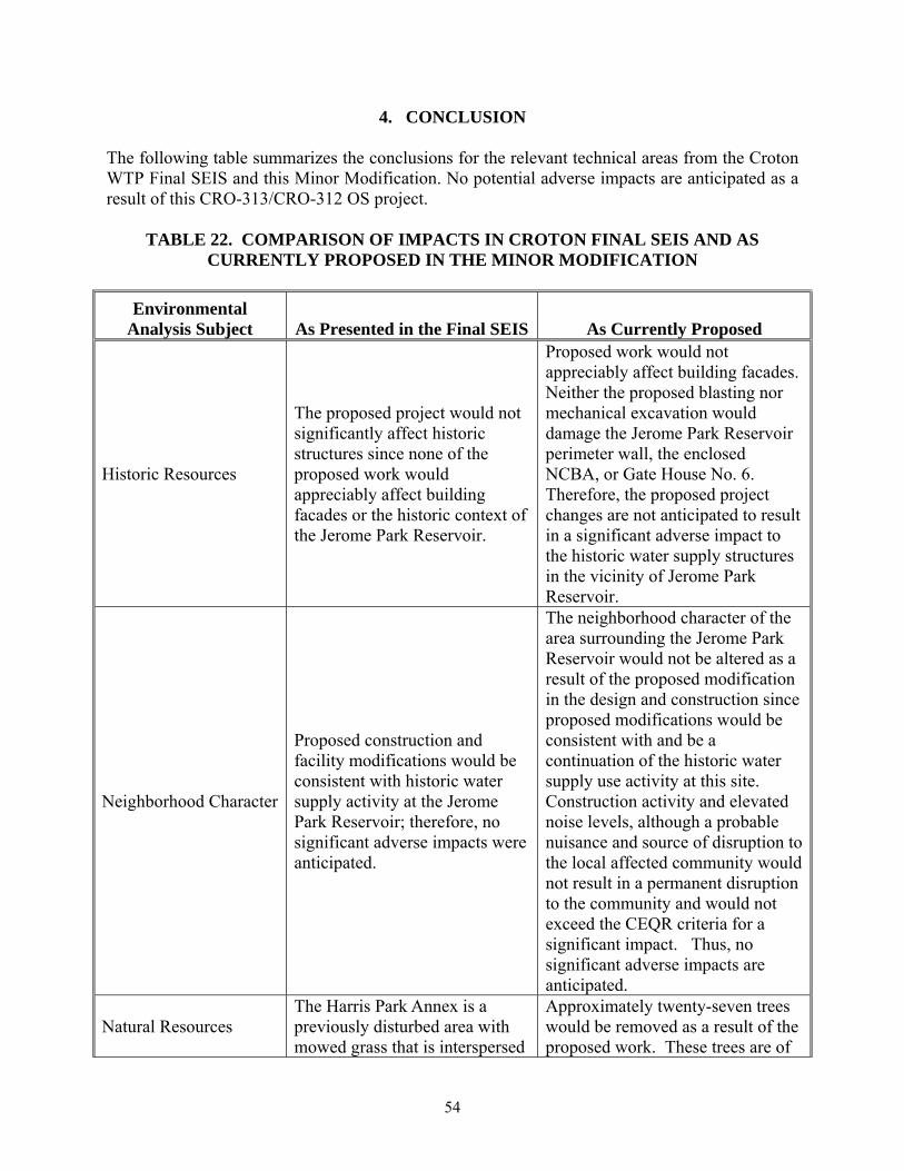
54
4. CONCLUSION The following table summarizes the conclusions for the relevant technical areas from the Croton WTP Final SEIS and this Minor Modification. No potential adverse impacts are anticipated as a result of this CRO-313/CRO-312 OS project.
TABLE 22. COMPARISON OF IMPACTS IN CROTON FINAL SEIS AND AS CURRENTLY PROPOSED IN THE MINOR MODIFICATION
Environmental Analysis Subject As Presented in the Final SEIS As Currently Proposed
Historic Resources
The proposed project would not significantly affect historic structures since none of the proposed work would appreciably affect building facades or the historic context of the Jerome Park Reservoir.
Proposed work would not appreciably affect building facades. Neither the proposed blasting nor mechanical excavation would damage the Jerome Park Reservoir perimeter wall, the enclosed NCBA, or Gate House No. 6. Therefore, the proposed project changes are not anticipated to result in a significant adverse impact to the historic water supply structures in the vicinity of Jerome Park Reservoir.
Neighborhood Character
Proposed construction and facility modifications would be consistent with historic water supply activity at the Jerome Park Reservoir; therefore, no significant adverse impacts were anticipated.
The neighborhood character of the area surrounding the Jerome Park Reservoir would not be altered as a result of the proposed modification in the design and construction since proposed modifications would be consistent with and be a continuation of the historic water supply use activity at this site. Construction activity and elevated noise levels, although a probable nuisance and source of disruption to the local affected community would not result in a permanent disruption to the community and would not exceed the CEQR criteria for a significant impact. Thus, no significant adverse impacts are anticipated.
Natural Resources The Harris Park Annex is a previously disturbed area with mowed grass that is interspersed
Approximately twenty-seven trees would be removed as a result of the proposed work. These trees are of
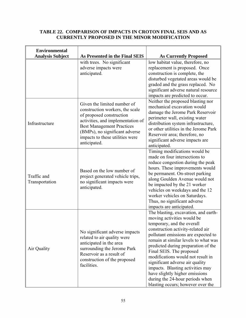
55
TABLE 22. COMPARISON OF IMPACTS IN CROTON FINAL SEIS AND AS CURRENTLY PROPOSED IN THE MINOR MODIFICATION
Environmental Analysis Subject As Presented in the Final SEIS As Currently Proposed
with trees. No significant adverse impacts were anticipated.
low habitat value, therefore, no replacement is proposed. Once construction is complete, the disturbed vegetated areas would be graded and the grass replaced. No significant adverse natural resource impacts are predicted to occur.
Infrastructure
Given the limited number of construction workers, the scale of proposed construction activities, and implementation of Best Management Practices (BMPs), no significant adverse impacts to these utilities were anticipated.
Neither the proposed blasting nor mechanical excavation would damage the Jerome Park Reservoir perimeter wall, existing water distribution system infrastructure, or other utilities in the Jerome Park Reservoir area; therefore, no significant adverse impacts are anticipated.
Traffic and Transportation
Based on the low number of project generated vehicle trips, no significant impacts were anticipated.
Timing modifications would be made on four intersections to reduce congestion during the peak hours. These improvements would be permanent. On-street parking along Goulden Avenue would not be impacted by the 21 worker vehicles on weekdays and the 12 worker vehicles on Saturdays. Thus, no significant adverse impacts are anticipated.
Air Quality
No significant adverse impacts related to air quality were anticipated in the area surrounding the Jerome Park Reservoir as a result of construction of the proposed facilities.
The blasting, excavation, and earth-moving activities would be temporary, and the overall construction activity-related air pollutant emissions are expected to remain at similar levels to what was predicted during preparation of the Final SEIS. The proposed modifications would not result in significant adverse air quality impacts. Blasting activities may have slightly higher emissions during the 24-hour periods when blasting occurs; however over the

56
TABLE 22. COMPARISON OF IMPACTS IN CROTON FINAL SEIS AND AS CURRENTLY PROPOSED IN THE MINOR MODIFICATION
Environmental Analysis Subject As Presented in the Final SEIS As Currently Proposed
duration of the project, the blasting scenario would result in less total emissions than the mechanical scenario because of the longer duration of the mechanical rock excavation scenario.
Noise
Potential noise impacts resulting from the use of on-site equipment during construction activities were determined for three sensitive receptors proximate. A noise attenuating barrier was recommended to reduce the construction-generated noise to levels below the 3-5 dBA CEQR threshold.
Noise attenuation measures would be implemented to reduce elevated noise levels to below CEQR noise thresholds in order to limit effects on nearby sensitive receptors. Blasting activities would be carefully monitored and would not be a consistent source of elevated noise levels throughout the day as compared with the mechanical excavation equipment. No significant adverse impacts from noise are anticipated.
Public Health
Proposed limited excavation would not create a health risk because the excavation areas would be relatively small and only a few pieces of heavy machinery would be involved.
A Blasting Plan and Quality of Life Plan would be implemented to minimize potential impacts to public health; therefore, no significant adverse impacts are anticipated.

ATTACHMENT A
HISTORIC AND ARCHAEOLOGICAL RESOURCES CORRESPONDENCE