mineral resources of the north fork of the little humboldt
TRANSCRIPT

Mineral Resources of the North Fork of the Little Humboldt River W.. .mess St Area Humboldt County, Nevada
U.S. GEOLOGICAL SURVEY BULLETIN 1732-A

Chapter A
Mineral Resources of the North Fork of the Little Humboldt River Wilderness Study Area, Humboldt County, Nevada
By JOCELYN A. PETERSON and WILLIAM D. HERAN,
U.S. Geological Survey
ANDREW M. LESZCYKOWSKI U.S. Bureau of Mines
U.S. GEOLOGICAL SURVEY BULLETIN 1732-A
MINERAL RESOURCES OF WILDERNESS STUDY AREAS:
LITTLE HUMBOLDT RIVER REGION, NEVADA

DEPARTMENT OF THE INTERIOR
DONALD PAUL MODEL, Secretary
U.S. GEOLOGICAL SURVEY
Dallas L. Peck, Director
UNITED STATES GOVERNMENT PRINTING OFFICE, WASHINGTON: 1986
For sale by theBooks and Open-File Reports SectionU.S. Geological SurveyFederal Center, Box 25425Denver, CO 80225
Library of Congress Cataloging-in-Publication Data
Peterson, Jocelyn A.Mineral resources of the North Fork of the Little Humboldt River Wilderness study area, Humboldt County, Nevada
(U.S. Geological Survey Bulletin 1732-A)BibliographySupt. of Docs, no.: I 19.3:1732-A1. Mines and mineral resources Nevada Little
Humboldt River Wilderness. 2 Little Humboldt RiverWilderness (Nev.) I. Heran, William D.II. Leszcykowski, Andrew M. III. Title. IV. Series.
QE75.B9 no. 1732-A 557.3 s 86-600046[TN24.N3] [553'.09793'54]
STUDIES RELATED TO WILDERNESS
Bureau of Land Management Wilderness Study Areas
The Federal Land Policy and Management Act (Public Law 94-579, October 21, 1976) requires the U.S. Geological Survey and the U.S. Bureau of Mines to conduct mineral surveys on certain areas to determine the mineral values, if any, that may be present. Results must be made available to the public and be submitted to the President and the Congress. This report presents the results of a mineral survey of the North Fork of the Little Humboldt River Wilderness Study Area (NV-020-827), Humboldt County, Nevada.

CONTENTS
Summary AlAbstract 1Character and setting 1 Mineral resource potential 1
Introduction 1Appraisal of identified resources 4 Assessment of potential for undiscovered resources 4
Geology 4 Geochemistry 5 Geophysics 6 Mineral and energy resources 6
Epithermal precious-metal vein deposits 6 Mercury deposits 7 Uranium deposits 7 Disseminated-gold deposits 8 Other commodities 8
References cited 8Appendix 1. Definition of levels of mineral resource potential
and certainty of assessment 10
FIGURES
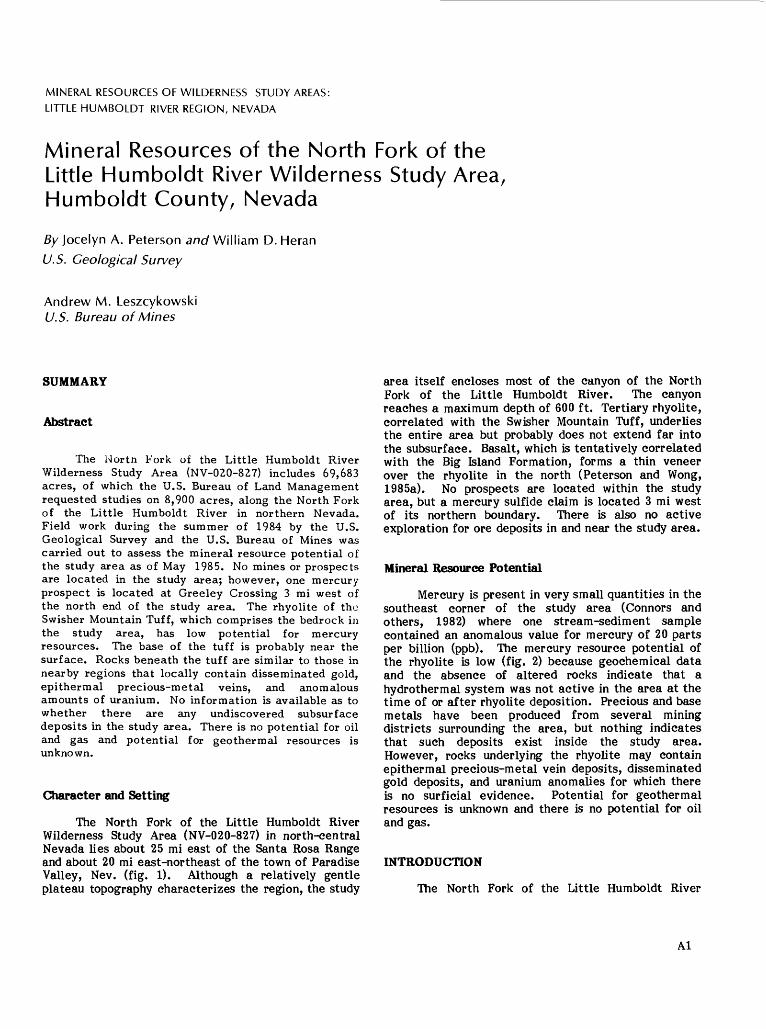
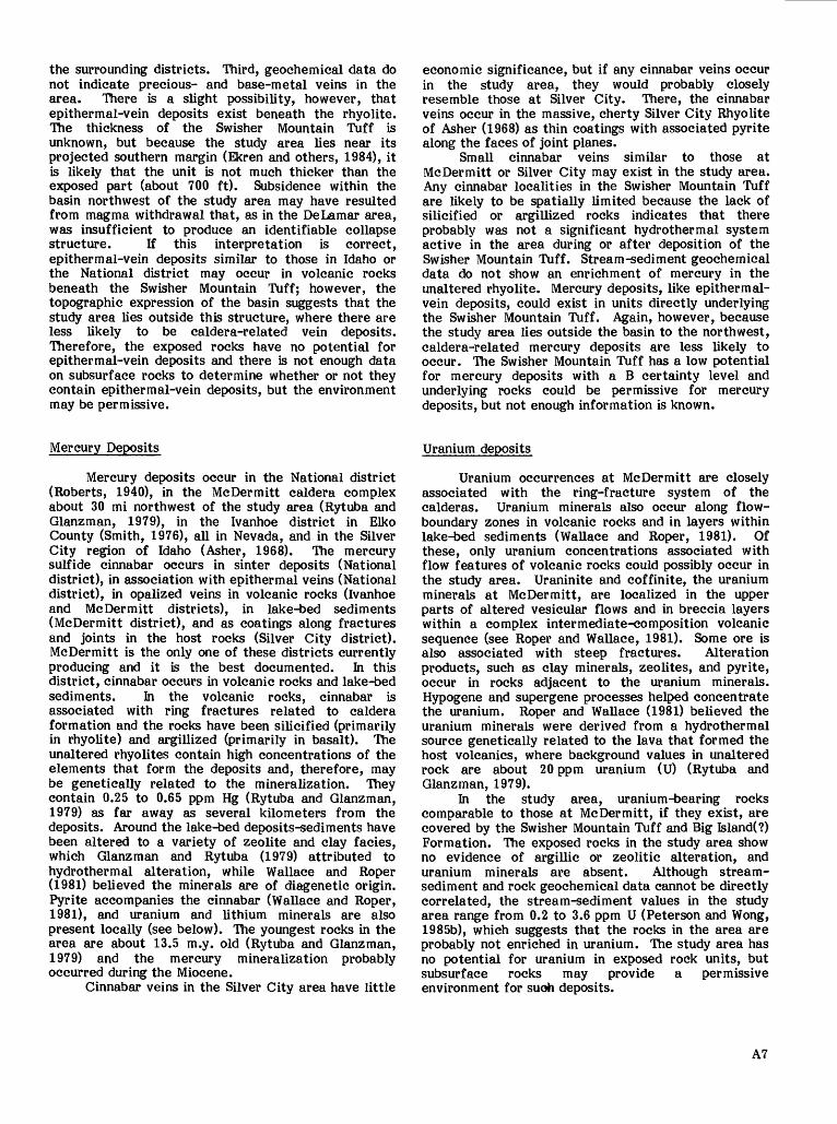
1. Index map showing location of the North Fork of the Little Humboldt River Wilderness Study Area A2
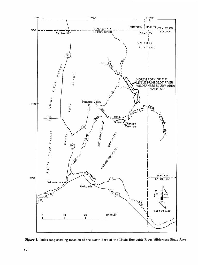
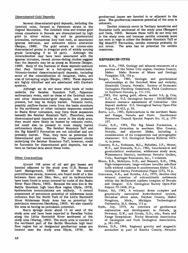
2. Map showing mineral resource potential of the iSforth Fork of the Little Humboldt River Wilderness Study Area 3
3. Major elements of mineral resource potential/certainty classification 10
V

MINERAL RESOURCES OF WILDERNESS STUDY AREAS:
LITTLE HUMBOLDT RIVER REGION, NEVADA
Mineral Resources of the North Fork of the Little Humboldt River Wilderness Study Area, Humboldt County, Nevada
By Jocelyn A. Peterson and William D. Heran
U.S. Geological Survey
Andrew M. Leszcykowski U.S. Bureau of Mines
SUMMARY
Abstract
The Hortft Fork of the Little Humboldt River Wilderness Study Area (NV-020-827) includes 69,683 acres, of which the U.S. Bureau of Land Management requested studies on 8,900 acres, along the North Fork of the Little Humboldt River in northern Nevada. Field work during the summer of 1984 by the U.S. Geological Survey and the U.S. Bureau of Mines was carried out to assess the mineral resource potential of the study area as of May 1985. No mines or prospects are located in the study area; however, one mercury prospect is located at Greeley Crossing 3 mi west of the north end of the study area. The rhyolite of the Swisher Mountain Tuff, which comprises the bedrock in the study area, has low potential for mercury resources. The base of the tuff is probably near the surface. Rocks beneath the tuff are similar to those in nearby regions that locally contain disseminated gold, epithermal precious-metal veins, and anomalous amounts of uranium. No information is available as to whether there are any undiscovered subsurface deposits in the study area. There is no potential for oil and gas and potential for geothermal resources is unknown.
Character and Setting
The North Fork of the Little Humboldt River Wilderness Study Area (NV-020-827) in north-central Nevada lies about 25 mi east of the Santa Rosa Range and about 20 mi east-northeast of the town of Paradise Valley, Nev. (fig. 1). Although a relatively gentle plateau topography characterizes the region, the study
area itself encloses most of the canyon of the North Fork of the Little Humboldt River. The canyon reaches a maximum depth of 600 ft. Tertiary rhyolite, correlated with the Swisher Mountain Tuff, underlies the entire area but probably does not extend far into the subsurface. Basalt, which is tentatively correlated with the Big Island Formation, forms a thin veneer over the rhyolite in the north (Peterson and Wong, 1985a). No prospects are located within the study area, but a mercury sulfide claim is located 3 mi west of its northern boundary. There is also no active exploration for ore deposits in and near the study area.
Mineral Resource Potential
Mercury is present in very small quantities in the southeast corner of the study area (Connors and others, 1982) where one stream-sediment sample contained an anomalous value for mercury of 20 parts per billion (ppb). The mercury resource potential of the rhyolite is low (fig. 2) because geochemical data and the absence of altered rocks indicate that a hydrothermal system was not active in the area at the time of or after rhyolite deposition. Precious and base metals have been produced from several mining districts surrounding the area, but nothing indicates that such deposits exist inside the study area. However, rocks underlying the rhyolite may contain epithermal precious-metal vein deposits, disseminated gold deposits, and uranium anomalies for which there is no surficial evidence. Potential for geothermal resources is unknown and there is no potential for oil and gas.
INTRODUCTION
The North Fork of the Little Humboldt River
Al
1 18°00'
42°00' _ _
1 17°30' 1 17°00'
41°30' -
41°00' -
co OREGON | IDAHO QWYHEE CO _
NORTH FORK OF THE LITTLE HUMBOLDT RIVER WILDERNESS STUDY AREA
(NV-020-827)
Paradise Valley
Chimney Reservoir
Figure 1. Index map showing location of the North Fork of the Little Humboldt River Wilderness Study Area.
A2
EXPLANATION
Area with low mineral resource potential, certainty level B (L/B). See Appendix 1 and Figure 3 for definition of levels of mineral resource potential and certainty of assessment
COMMODITIES
Hg Mercury
TYPES OF DEPOSITS AND OCCURRENCES
[ 1 ] Mercury veins in Tertiary volcanic terrane
CORRELATION OF MAP UNITS
TERTIARY
DESCRIPTION OF MAP UNITS
Tb BIG ISLAND (?) FORMATION (MIOCENE)-- Basalt
Ts SW1SHER MOUNTAIN TUFF (MIOCENE)-- Low silica rhyolite
CONTACT
FAULT-Dashed where inferred
APPROXIMATE BOUNDARY OFNORTH FORK OF THE LITTLE HUMBOLDT RIVER
WILDERNESS STUDY AREA (NV 020827)
Geology from Pelerson ond Wong (1985c
Figure 2. Map showing mineral resource potential of the North Fork of the Little Humboldt River Wilderness Study Area.
A3
Wilderness Study Area (NV-020-827) encompasses 69,683 acres, of which the U.S. Bureau of Land Management requested mineral surveys on 8,900 acres, in north-central Nevada along the southwestern boundary of the Owyhee Plateau (fig. 1). The surveyed part of the area covers 15 mi of the steep, narrow canyon of the North Fork of the Little Humboldt River. Elevations range from 4,700 to 5,600 ft at the bottom of the canyon and from 5,300 to 5,800 ft along the canyon rim, with the greatest depth of the canyon being about 600 ft. The bottom of the canyon can be reached only by hiking down tributary canyons. The North Fork of the Little Humboldt River is a perennial stream but all of its tributaries are intermittent. The arid climate allows the growth of desert brush, predominantly sagebrush, along the canyon rim; willows, dogwood, several grasses, and brambles grow along the river where water is plentiful.
The area lies about 25 mi east of the Santa Rosa Range, 20 mi east-northeast of the town of Paradise Valley, Nev., and approximately 55 mi northeast of Winnemucca, Nev. Maintained gravel roads lead from Paradise Valley to Chimney Reservoir (fig. 1). From there, the quality of the roads decreases gradually until four-wheel drive is required in places and passage during wet weather is unadvisable. All parts of the area can be reached on foot from jeep trails that parallel both sides of the study area.
The U.S. Bureau of Mines personnel searched the library and examined Humboldt County and U.S. Bureau of Land Management mining and mineral lease records to determine if the area had undergone any mining or prospecting. U.S. Bureau of Mines, state, and other production records were also searched. Mining activities that may not have been recorded were searched for by ground and air reconnaissance.
The U.S. Geological Survey mapped the geology of the study area during a two-week period in the summer of 1984 and collected rock samples for geochemical analysis (Peterson and Wong, 1985b). Reconnaissance mapping for the geologic map of Nevada (Stewart and Carlson, 1978) and for a report on mineral deposits in Humboldt County (Willden, 1964) did not include field work in this area. The current study (Peterson and Wong, 1985a) provides the only detailed geologic map of the study area (fig. 2).
Personnel at the U.S. Bureau of Land Management office in Winnemucca generously provided information about road access problems due to unexpectedly late winter storms and freely shared their information about the area's geology. The owners of the Bullhead Ranch kindly allowed us to use jeep trails on their property to obtain access to U.S. Bureau of Land Management land on the west side of the river canyon.
APPRAISAL OF IDENTIFIED RESOURCES
By_ Andrew M. Leszcykowski, U.S. Bureau of Mines
The U.S. Bureau of Mines investigation showed that there are no mines or prospects, or related activities in the North Fork of the Little Humboldt River Wilderness Study Area. The nearest mining activity is 20 to 25 mi from the study area in the
Potosi (tungsten and gold), Poverty Peak (mercury), and Buckskin (tungsten and gold) mining districts. The geology of those mining districts is different from that exposed in the study area.
Samples from small accumulations of sand and gravel along the river contained no detectable gold or other significant heavy minerals.
ASSESSMENT OF POTENTIAL FOR UNDISCOVERED RESOURCES
By Jocelyn A. Peterson and William D. Heran, U.S. Geological Survey
Geology
The North Fork of the Little Humboldt River Wilderness Study Area lies near the boundary between the Snake River Plain and Basin and Range tectonic provinces. The Owyhee Plateau, which includes the study area, forms the southernmost part of the Snake River Plain. Tertiary and Quaternary volcanic tuffs and flows with minor interbedded fluviatile and lacustrine sedimentary rocks characterize the Owyhee Plateau; however, older rocks are exposed at many localities on the plateau. The volcanic rocks form a bimodal rhyolite-basalt suite in which thick rhyolitic sequences are covered by a thin basaltic veneer. Extensional tectonic features, including block-faulted subparallel mountain ranges separated by broad alluvial valleys, characterize the Basin and Range province. Near the study area, the mountain ranges trend north to slightly northeast and are composed of a variety of sedimentary, volcanic, and intrusive rocks spanning the Phanerozoic Era (Stewart and Carlson, 1978).
The study area incorporates characteristics of both tectonic provinces. The rocks of the area are part of the bi modal rhyolite-basalt suite from the Owyhee Plateau, whereas structurally the area resembles the Basin and Range province and is cut by several high-angle faults of small displacement. A well-defined northwest-trending lineament in central Nevada that coincides with magnetic highs, basaltic dike swarms, and faults (Mabey and others, 1978; Stewart and others, 1975) transects the study area. Although it was previously thought that a conspicuous alignment of mining areas in north-central Nevada (Roberts, 1960) corresponded to the lineament (Stewart and others, 1975), the two are now considered to be separate trends (R.J. Madrid, oral commun., 1985). The eastern edge of a saucer-shaped topographic feature that may indicate a caldera (Ekren and others, 1984) lies about 7 mi west of the north boundary of the study area. Ore deposits in the Santa Rosa Range coincide with the western and southern edges of this feature (Vikre, 1985).
The Swisher Mountain Tuff, stratigraphically the lowest exposed rock unit of the study area, is at least 700 ft thick. Its base is not exposed but is probably close to the surface at the bottom of the canyon based on Ekren and others' (1974) projected extent of the unit. Flow banding 1 to 5 in. thick is nearly ubiquitous and flat lying in only a few places; locally, laminations form tight recumbent folds. Both petrographic thin
A4

sections and hand specimens show phenocrysts of plagioclase, potassium feldspar, clinopyroxene, and opaque oxides occurring in a gray, pink, maroon, or lavender groundmass. The groundmass is partially to totally devitrified. Major-element geochemical analyses indicate that this tuff is a low-silica rhyolite (see table 1, Peterson and Wong, 1985a), and the absence of hornblende and biotite indicates that the magma had a low water content. The Swisher Mountain Tuff also contains minor vitrophyre and pumiceous tuff. A black porphyritic vitrophyre occurs as lenses throughout the rhyolite, most extensively near the top of the unit. It has the same phenocryst mineralogy as the rhyolite, but the groundmass consists of flow-banded perlitic glass containing feldspar microlites. In some localities the vitrophyre forms angular clasts in an orange tuffaceous matrix. This breccia is particularly common along the east rim of the canyon and extends to the hills farther east. At one location midway down the side of the canyon, an orange tuff about 10 ft thick contains abundant pumice lapilli and possible glass shards. A thin section of the pumiceous tuff indicates that it is non-welded. The rhyolite sequence suggests that the unit is an ash-flow tuff that melted and destroyed most of the pyroclastic textures and developed flow bands. Based on mineralogic and chemical affinities, Peterson and Wong (1985a) correlated this rhyolite with the Miocene Swisher Mountian Tuff (13.85 Ma, Ekren and others, 1984).
Basalt flows, tentatively correlated with the Miocene Big Island Formation of Coats (1985), cover the Swisher Mountain Tuff over much of the study area (Peterson and Wong, 1985a). The basalt is at most about 400 ft thick, but individual flow sheets are only 15 to 20 ft thick. The unit thins southward until a single flow comes to a narrow point along the west rim of the canyon (fig. 2). A dense lower part and a vesicular top that includes about one-third of the thickness of the flow sheet characterizes each flow. The flows are flat lying or gently undulating. Most of the basalt is dark gray and fine grained, although medium-grained phases are present locally. Thin sections show that phenocrysts of olivine occur in a groundmass of plagioclase, pyroxene, opaque oxides, and olivine. A diktytaxitic texture is prevalent in fine-grained rocks. Chemically, these rocks are tholeiitic high-alumina basalts (Coats, 1985).
Calcite locally fills vesicles in the basalt and several areas within the rhyolite contain cherty silica as breccia matrix or cavity fillings. Both of these minerals were probably deposited from ground waters percolating through the area and are not related to mineralizing systems. Neither the Swisher Mountain Tuff nor the Big Island(?) Formation show evidence of alteration in outcrops. Except for narrow weathering rinds, the rocks are fresh. Thin sections also do not indicate alteration. Phenocrysts are fresh. In the Swisher Mountain Tuff, many of the phenocrysts have been partially resorbed by the groundmass but have not otherwise been affected.
Information about subsurface rocks is absent. However, we believe that the subsurface rocks are most likely volcanic, possibly outflow-facies rocks from the basin structure to the northwest or other volcanic sequences related to the Snake River Plain.
These rocks probably lie close to the surface, based on the available information for the Swisher Mountain Tuff. It is these subsurface rocks that are the potential host rocks for most of the deposit types discussed in the sections below.
Geochemistry
Twenty-two rock and 32 stream-sediment samples were collected in and near the wilderness study area to assess the geochemical characteristics of the area. The rock samples were crushed, prepared, and analyzed by semiquantitative emission spectrographic and flame atomic-absorption methods at the U.S. Geological Survey in Denver, Colo. (Peterson and Wong, 1985b). All but two rhyolite samples, which contain visible introduced silica, are representative of the basalt and rhyolite from which they were collected. Barringer Resources, Inc., collected, prepared, and analyzed the 32 stream- sediment samples (Connors and others, 1982). The samples were analyzed by a variety of methods, including induction-coupled argon-plasma emission, atomic absorption, colorimetry, fluorimetry, and carbon fusion and specific ion electrode to determine concentrations of oxides and trace elements. Peterson and Wong (1985b) give numerical data for both rock and stream-sediment samples.
The geochemical data show little variation within each rock type; however, the Swisher Mountain Tuff can be easily distinguished from the Big Island(?) Formation by the data for several elements. Even the two rhyolite samples, containing introduced silica show trace-element concentrations similar to the other rhyolite samples except that a 12 ppm arsenic (As) concentration was detected (by atomic absorption) in the siliceous sample from the Red Hills. The other rhyolite samples contain less than 5 ppm As (the lower determination limit). Because the measured As value is not associated with any other geochemically high values and the rocks in the Red Hills are not hydrothermally altered, it probably indicates a locally above-average background value.
The stream-sediment data show a similar lack of variation in reported trace-element values. There are four isolated above-average values, two for mercury (Hg), one for As, and one for fluorine (F). The two Hg values (20 and 30 ppb) came from samples collected northeast and southeast of the study area. The 20-ppm value for As came from a sample collected 3 mi southeast of the study area. As with the rock data, these values are so small that they represent background fluctuations, particularly as they occur some distance from one another. A 2,400-ppm value for F was obtained from a sample collected 8 mi northeast of the study area. This value is three to four times higher than the others in the geochemical- sampling area. Again, the isolated nature of this anomaly and the lack of other indicators of hydrothermal activity probably precludes it from association with a mineralizing system. Thus, the geochemical data for rock and stream-sediment samples indicate that it is unlikely that mineral deposits exist in the study area.
A5

Geophysics
The regional geophysical setting in north-central Nevada includes several prominent lineaments. The northern Nevada rift is a northwest-trending lineament crossing north-central Nevada that is characterized by a positive aeromagnetic anomaly produced by basaltic dike swarms and related volcanic flows (Mabey, 1966; Mabey and others, 1978; Zoback and Thompson, 1978). The lineament also contains a northwest- trending zone of closely spaced faults cut by many northeast-trending basin-and-range faults.
The broad, northeast-trending Humboldt structural zone extends across Nevada to Yellowstone, Wyo. (Rowan and Wetlaufer, 1981). Many northeast- trending, left-lateral, strike-slip faults define this zone. The northeast-trending Midas lineament system lies within the Humboldt structural zone. Landsat images of the Midas lineament show prominent northeast-trending structure and topography. The southeastern margin of the Humboldt structural zone lies along a line of high gravity anomalies; the Battle Mountain heat-flow anomaly also corresponds to this northeast-trending zone. The Humboldt structural zone and the Midas lineament both cross the northern Nevada rift system.
Gravimetric data are not available for the study area, but we have drawn general conclusions about the mineral resources from the regional airborne magnetic data that cover parts of the Vya and McDermitt 1° by 2° quadrangles in northern Nevada (U.S. Geological Survey, 1972). The aeromagnetic survey was flown at 3,200 to 4,300 ft above the ground surface (about 9,000 ft above sea level), and flight lines were spaced 1 mi apart. We examined the data covering latitudes 41°30' to 42° and longitudes 117° to 117°15', which includes the North Fork of the Little Humboldt River Wilderness Study Area. The contour interval is 20 gammas and values range from 2,400 to 2,800 gammas with a regional gradient of 9 gammas/mi removed in the northeast direction.
The general trend of the magnetic anomalies in this area corresponds to the northwest trend of the northern Nevada rift magnetic anomaly. Depths to the source of several anomalies were estimated at 3,000 ft, using the slope-distance rule. Thus, the data reflect near-surface variations in the rock types, because the height of the aircraft is about 3,000 ft above the ground.
The northwest part of the area studied shows higher magnetic values than the southeast part, reflecting either the topographic trend or a change in magnetization between the Big Island(?) Formation and Swisher Mountain Tuff. A steep magnetic gradient in the southern part of the area studied has traditionally been correlated with deep-rooted feeder dikes of the northern Nevada rift (Robinson, 1970; Zoback and Thompson, 1978).
Mineral and Energy Resources
The North Fork of the Little Humboldt River Wilderness Study Area is situated between a number of mining districts that contain base and precious metals in epithermal-vein deposits, mercury deposits, uranium
occurrences, and disseminated-gold deposits. The area also lies at the north end of two separate linear trends of ore deposits. One trend includes the Getchell, Pinson, and Preble disseminated-gold deposits in the Osgood Mountains south of the study area and a newly discovered deposit near Chimney Reservoir (W.C. Bagby, oral commun, 1985). The other trend includes the Midas, Ivanhoe, Bootstrap, and Lynn districts that contain epithermal-and disseminated-gold deposits southeast of the study area. Some of the districts lie outside the Owyhee Plateau tectonic province and, because the mineralized rocks in these districts are older than the Swisher Mountain Tuff, it is possible that the rocks were mineralized prior to the eruption of the Swisher Mountain Tuff. Nevertheless, the characteristics of several nearby deposits are examined here because there is a slight chance that similarly mineralized rocks may occur within the study area, particularly in subsurface rocks. Deposit types for which there is no surficial evidence, but which could possibly occur in subsurface rock units, are described and evaluated, but not classified as to their potential, because insufficient information exists about the subsurface rocks to give a more definite assessment of the potential for these types of deposits. This assessment was made as of May 1985 and follows the definitions of mineral resource assessment and the levels of certainty outlined in Appendix 1.
Epithermal Precious-metal Vein Deposits
In several districts near the study area, Tertiary volcanic rocks contain gold- and silver-bearing quartz veins. These include the National district in the Santa Rosa Range (Roberts, 1940), the Cornucopia, Midas, and Jarbidge districts in Elko County, Nev., east and southeast of the study area (Smith, 1976), and the Silver City and DeLamar districts in Idaho (Asher, 1968; Pansze, 1975; Halsor, 1983). In these districts, quartz veins host native gold and a wide variety of sulfide and sulfosalt minerals, particularly those containing silver. All these districts contain rocks that have been hydro therm ally altered to form bleached outcrops characterized by silicic alteration. In some of the districts, alteration products such as adularia, sericite, clay minerals, and chlorite have also formed. Four altered zones have been identified in the Silver City district; from the vein outward they are potassium silicate, quartz-sericite, argillic, and propylitic zones (Pansze, 1975). The veins in the DeLamar deposit formed in ring fractures suggestive of a caldera environment in which insufficient lavas were extruded to form collapse structures (Asher, 1968). The mineral deposits in the Midas district have been dated at 15 Ma (Smith, 1976), those at Silver City at 15.6 Ma (Pansze, 1975), and those at DeLamar at 15 Ma ago (Halsor, 1983).
The exposed rocks in the study area are not likely to contain base- and precious-metal epithermal veins similar to those outside the area for a number of reasons. First, the hydrothermally altered rocks that accompany the known epithermal veins are absent. Second, the Swisher Mountain Tuff and Big Island(?) Formation may be younger than the mineralization in
A6
the surrounding districts. Third, geochemical data do not indicate precious- and base-metal veins in the area. There is a slight possibility, however, that epithermal-vein deposits exist beneath the rhyolite. The thickness of the Swisher Mountain Tuff is unknown, but because the study area lies near its projected southern margin (Ekren and others, 1984), it is likely that the unit is not much thicker than the exposed part (about 700 ft). Subsidence within the basin northwest of the study area may have resulted from magma withdrawal that, as in the DeLamar area, was insufficient to produce an identifiable collapse structure. If this interpretation is correct, epithermal-vein deposits similar to those in Idaho or the National district may occur in volcanic rocks beneath the Swisher Mountain Tuff; however, the topographic expression of the basin suggests that the study area lies outside this structure, where there are less likely to be caldera-related vein deposits. Therefore, the exposed rocks have no potential for epithermal-vein deposits and there is not enough data on subsurface rocks to determine whether or not they contain epithermal-vein deposits, but the environment may be permissive.
economic significance, but if any cinnabar veins occur in the study area, they would probably closely resemble those at Silver City. There, the cinnabar veins occur in the massive, cherty Silver City Rhyolite of Asher (1968) as thin coatings with associated pyrite along the faces of joint planes.
Small cinnabar veins similar to those at McDermitt or Silver City may exist in the study area. Any cinnabar localities in the Swisher Mountain Tuff are likely to be spatially limited because the lack of silicified or argillized rocks indicates that there probably was not a significant hydrothermal system active in the area during or after deposition of the Swisher Mountain Tuff. Stream-sediment geochemical data do not show an enrichment of mercury in the unaltered rhyolite. Mercury deposits, like epithermal- vein deposits, could exist in units directly underlying the Swisher Mountain Tuff. Again, however, because the study area lies outside the basin to the northwest, caldera-related mercury deposits are less likely to occur. The Swisher Mountain Tuff has a low potential for mercury deposits with a B certainty level and underlying rocks could be permissive for mercury deposits, but not enough information is known.
Mercury Deposits
Mercury deposits occur in the National district (Roberts, 1940), in the McDermitt caldera complex about 30 mi northwest of the study area (Rytuba and Glanzman, 1979), in the Ivanhoe district in Elko County (Smith, 1976), all in Nevada, and in the Silver City region of Idaho (Asher, 1968). The mercury sulfide cinnabar occurs in sinter deposits (National district), in association with epithermal veins (National district), in opalized veins in volcanic rocks (Ivanhoe and McDermitt districts), in lake-bed sediments (McDermitt district), and as coatings along fractures and joints in the host rocks (Silver City district). McDermitt is the only one of these districts currently producing and it is the best documented. In this district, cinnabar occurs in volcanic rocks and lake-bed sediments. In the volcanic rocks, cinnabar is associated with ring fractures related to caldera formation and the rocks have been silicified (primarily in rhyolite) and argillized (primarily in basalt). The unaltered rhyolites contain high concentrations of the elements that form the deposits and, therefore, may be genetically related to the mineralization. They contain 0.25 to 0.65 ppm Hg (Rytuba and Glanzman, 1979) as far away as several kilometers from the deposits. Around the lake-bed deposits-sediments have been altered to a variety of zeolite and clay facies, which Glanzman and Rytuba (1979) attributed to hydrothermal alteration, while Wallace and Roper (1981) believed the minerals are of diagenetic origin. Pyrite accompanies the cinnabar (Wallace and Roper, 1981), and uranium and lithium minerals are also present locally (see below). The youngest rocks in the area are about 13.5 m.y. old (Rytuba and Glanzman, 1979) and the mercury mineralization probably occurred during the Miocene.
Cinnabar veins in the Silver City area have little
Uranium deposits
Uranium occurrences at McDermitt are closely associated with the ring-fracture system of the calderas. Uranium minerals also occur along flow- boundary zones in volcanic rocks and in layers within lake-bed sediments (Wallace and Roper, 1981). Of these, only uranium concentrations associated with flow features of volcanic rocks could possibly occur in the study area. Uraninite and coffinite, the uranium minerals at McDermitt, are localized in the upper parts of altered vesicular flows and in breccia layers within a complex intermediate-composition volcanic sequence (see Roper and Wallace, 1981). Some ore is also associated with steep fractures. Alteration products, such as clay minerals, zeolites, and pyrite, occur in rocks adjacent to the uranium minerals. Hypogene and supergene processes helped concentrate the uranium. Roper and Wallace (1981) believed the uranium minerals were derived from a hydrothermal source genetically related to the lava that formed the host volcanics, where background values in unaltered rock are about 20 ppm uranium (U) (Rytuba and Glanzman, 1979).
In the study area, uranium-bearing rocks comparable to those at McDermitt, if they exist, are covered by the Swisher Mountain Tuff and Big Island(?) Formation. The exposed rocks in the study area show no evidence of argillic or zeolitic alteration, and uranium minerals are absent. Although stream- sediment and rock geochemical data cannot be directly correlated, the stream-sediment values in the study area range from 0.2 to 3.6 ppm U (Peterson and Wong, 1985b), which suggests that the rocks in the area are probably not enriched in uranium. The study area has no potential for uranium in exposed rock units, but subsurface rocks may provide a permissive environment for suoh deposits.
A7
Disseminated-Gold Deposits
Several disseminated-gold deposits, including the Getchell mine, formed in Paleozoic strata in the Osgood Mountains. The Getchell mine and similar gold mines elsewhere in Nevada are characterized by high gold to silver ratios, Hg and As geochemical anomalies, carbonaceous limy host rock, an associated igneous intrusion, and extensive silicic alteration (Berger, 1980). The gold occurs as micron-size disseminated grains in irregular pods of widely varying grade (averaging 9 to 10 ppm). Although the mineralization may have been associated with the igneous intrusion, recent zircon-dating studies suggest that the deposits may be as young as Miocene (Berger, 1980). Many of the features of these deposits indicate that they formed in a hot-spring environment. Volcanic-hosted disseminated-gold deposits, including some of the mineralization at DeLamar, Idaho, are also of hot-spring origin (Berger, 1983). These deposits are highly silicified and are associated with fracture systems.
Although we do not know what kinds of rocks underlie the Swisher Mountain Tuff, Paleozoic sedimentary rocks, such as those at the Getchell mine and other disseminated-gold deposits, are probably present, but may be deeply buried. Volcanic rocks, possibly outflow-facies rocks from the basin structure to the northwest or other volcanic sequences related to Snake River volcanism, may form thick sequences beneath the Swisher Mountain Tuff. Therefore, were disseminated-gold deposits to occur in the study area, they would more likely be hosted by volcanic rocks, but could also be present in more deeply buried sedimentary strata. The Swisher Mountain Tuff and the Big Island(?) Formation are not silicified and are probably barren. Thus, they have no potential for disseminated gold resources. The unexposed strata underlying the Swisher Mountain Tuff, however, could be favorable for disseminated gold deposits, but we have no factual data about these rocks.
Other Commodities
Almost 500 acres of oil and gas leases are located adjacent to the study area (U.S. Bureau of Land Management, 1983). Most of the known petroliferous strata, however, are found south of a line between Reno and Elko, Nev., and no hydrocarbons have been found in areas covered by rocks of the Snake River Plain (Bortz, 1983). Because the area lies in the Battle Mountain high heat-flow region (Hyde, 1979), hydrocarbon accumulations are unlikely. A recent assessment of petroleum potential of wilderness lands indicates that the North Fork of the Little Humboldt River Wilderness Study Area has no potential for petroleum resources (Sandberg, 1983). We also classify the area as having no petroleum potential.
Warm springs occur about 15 mi west of the study area and have been reported in Paradise Valley along the Little Humboldt River southwest of the study area (Waring, 1965). The study area is located in the northeast part of the Battle IWountain high heat flow region but no designated geothermal areas are located near the study area (Hyde, 1979). No
geothermal leases are located in or adjacent to the area. The geothermal resource potential of the area is unknown.
Zeolite minerals occur in Tertiary lacustrine and fluviatile tuffs southwest of the study area (Sheppard and Gude, 1983). Because these tuffs do not crop out in the study area and because zeolite minerals were not seen in vugs in either the Swisher Mountain Tuff or Big Island(?) Formation, zeolite minerals probably do not occur. The area has no potential for zeolite resources.
REFERENCES CITED
Asher, R.R., 1968, Geology and mineral resources of a portion of the Silver City region, Owyhee County, Idaho: Idaho Bureau of Mines and Geology Pamphlet 138, 106 p.
Berger, B.R., 1980, Geologic and geochemical relationships at the Getchell Mine and vicinity, Humboldt County, Nevada: Society of Economic Geologists Fieldtrip Guidebook, Field Conference to Northern Nevada, p. 111-135.
__1983, Hot spring gold, silver, model 5.6, in Cox, D.P., ed., U.S. Geological Survey - INGEOMINAS mineral resource assessment of Colombia: Ore deposit models: U.S. Geological Survey Open-File Report 83-423, p. 38.
Bortz, L.C., 1983, Hydrocarbons in the northern Basin and Range, Nevada and Utah: Geothermal Resources Council Special Report No. 13, p. 179- 197.
Coats, R.R., 1985, The Big Island Formation, a Miocene formation in northern Elko County, Nevada, and adjacent Idaho, including a consideration of its composition and petrographic character: U.S. Geological Survey Bulletin 1605- A, in press.
Connors, R.A., Robinson, M.L., Bukofski, J.F., Meyer, W.T., and Howarth, R.J., 1982, Geochemical and geostatistical evaluation, wilderness study area, Winnemucca District, northwest Nevada: Golden, Colo., Barringer Resources, Inc., 5 volumes.
Ekren, E.B., Mclntyre, D.H., and Bennett, E.H., 1984, High-temperature, large-volume lavalike ash-flow tuffs without calderas in southwestern Idaho: U.S. Geological Survey Professional Paper 1272, 76 p.
Glanzman, R.K., and Rytuba, J.J., 1979, Zeolite-clay mineral zonation of volcaniclastic sediments within the McDermitt caldera complex of Nevada and Oregon: U.S. Geological Survey Open-File Report 79-1668, 25 p.
Halsor, Sid, 1983, A volcanic dome complex and genetically associated hydrothermal system, DeLamar silver mine, Owyhee County, Idaho: Houghton, Mich., Michigan Technological University, M.S. thesis, 111 p.
Hyde, Joy, 1979, An overview of geothermal exploration and development in Nevada, in Newman, G.W., and Goode, H.D., eds., Basin and Range Symposium: Rocky Mountain Association of Geologists and Utah Geological Association, p. 381-386.
Mabey, D.R., 1966, Regional gravity and magnetic anomalies in part of Eureka County, Nevada:
A8
Society of Exploration Geophysicists 1 Mining Geophysics, Case Histories, v. 1, p. 77-83.
Mabey, D.R., Zietz, Isidore, Eaton, G.P., and Kleinkopf, M.D., 1978, Regional magnetic patterns in part of the Cordillera in the Western United States, ill Smith, R.B., and Eaton, G.P., eds., Cenozoic tectonics and regional geophysics of the western Cordillera: Geological Society of America Memoir 152, p. 93-106.
Pansze, A.J., Jr., 1975, Geology and ore deposits of the Silver City-DeLamar-Flint region, Owyhee County, Idaho: Idaho Bureau of Mines and Geology Pamphlet 161, 79 p.
Peterson, J.A., and Wong, George, 1985a, Geologic map of the North Fork of the Little Humboldt River Wilderness Study Area, Humboldt County, Nevada: U.S. Geological Survey Miscellaneous Field Studies Map MF-1815, scale 1:24,000 in press .
__1985b, Geochemical analyses of rock and stream- sediment samples from the North Fork of the Little Humboldt River Wilderness Study Area, Humboldt County, Nevada: U.S. Geological Survey Open-File Report 85-373, 10 p.
Roberts, R.J., 1940, Quicksilver deposit at Buckskin Peak, National mining district, Humboldt County, Nevada: U.S. Geological Survey Bulletin 922-E, p. 115-133.
__I960, Alinement of mining districts in north- central Nevada: U.S. Geological Survey Professional Paper 400-B, p. B17-B19.
Robinson, S.E., 1970, Relations between geological structure and aeromagnetic anomalies in central Nevada: Geological Society of America Bulletin, v. 81, p. 2045-2060.
Roper, M.W., and Wallace, A.B., 1981, Geology of the Aurora uranium prospect, Malheur County, Oregon, in Goodell, P.C., and Waters, A.C., eds., Uranium in volcanic and volcaniclastic rocks: American Association of Petroleum Geologists, Studies in Geology, no. 13, p. 81-88.
Rowan, L.C., and Wetlaufer, P.H., 1981, Relation between regional lineament systems and structural zones in Nevada: American Association of Petroleum Geologists Bulletin, v. 65, p. 1414-1429.
Rytuba, J.J., and Glanzman, R.K., 1979, Relation of mercury, uranium, and lithium deposits to the McDermitt caldera complex, Nevada-Oregon, in
Ridge, J.D., ed., Papers on mineral deposits ofwestern North America: Nevada Bureau of Minesand Geology Report 33, p. 109-117.
Sandberg, C.A., 1983, Petroleum potential ofwilderness lands, Nevada: U.S. Geological SurveyMiscellaneous Investigations Series Map 1-1542,scale 1:1,000,000.
Sheppard, R.A., and Gude, A.J., 3d, 1983, Zeolites inTertiary tuffs along the Little Humboldt River,Humboldt and Elko Counties, Nevada: U.S.Geological Survey Open-File Report 83-458, 10 p.
Smith, R.M., 1976, Mineral resources of Elko County,Nevada: U.S. Geological Survey Open-File Report76-56, 194 p.
Stewart, J.H., and Carlson, J.E., 1978, Geologic mapof Nevada: U.S. Geological Survey, scale1:500,000.
Stewart, J.H., Walker, G.W., and Kleinhampl, F.J.,1975, Oregon-Nevada lineament: Geology, v. 3,no. 5, p. 265-268.
U.S. Bureau of Land Management, 1983, WinnemuccaWilderness Technical Report: For 18 wildernessstudy areas in northwest Nevada: U.S. Bureau ofLand Management Winnemucca, Nev. , 408 p.
U.S. Geological Survey, 1972, Aeromagnetic map ofthe Vya and McDermitt 1° by 2 quadrangles,Nevada: U.S. Geoloical Survey Open-File Report72-393, scale 1:250,000.
Vikre, P.G., 1985, Precious metal vein systems in theNational district, Humboldt County, Nevada:Economic Geology, v. 80, p. 360-393.
Wallace, A.B., and Roper, M.W., 1981, Geology anduranium deposits along the northeastern margin,McDermitt caldera complex, Oregon, in Goodell,P.C., and Waters, A.C., eds., Uranium in volcanicand volcaniclastic rocks: American Association ofPetroleum Geologists, Studies in Geology, no. 13,p. 73-79.
Waring, G.A., 1965, Thermal springs of the UnitedStates and other countries of the world-asummary: U.S. Geological Survey ProfessionalPaper 492, 383 p.
Willden, Ronald, 1964, Geology and mineral deposits ofHumboldt County, Nevada: Nevada Bureau ofMines Bulletin 59, 154 p.
Zoback, M.L., and Thompson, G.A., 1978, Basin andRange rifting in northern Nevada: clues from amid-Miocene rift and its subsequent offests:Geology, v. 6, p. 111-116.
A9

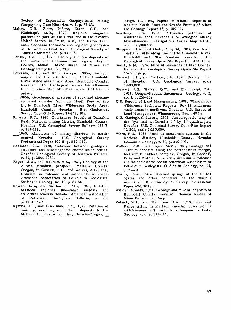
APPENDIX 1. Definition of levels of mineral resource potential and certainty of assessment.
Mineral resource potential is defined as the likelihood of the presence of mineral resources in a defined area; it is not a measure of the amount of resources or their profitability.
Mineral resources are concentrations of naturally occurring solid, liquid, or gaseous materials in such form and amount that economic extraction of a com modity from the concentration is currently or poten tially feasible.
Low mineral resource potential is assigned to areas where geologic, geochemical, and geophysical characteristics indicate a geologic environment where the existence of resources is unlikely. This level of potential embraces areas of dispersed mineralized rock as well as areas having few or no indications of mineralization. Assignment of low potential requires specific positive knowledge; it is not used as a catchall for areas where adequate data are lacking.
Moderate mineral resource potential is assigned to areas where geologic, geochemical, and geophysical characteristics indicate a geologic environment favorable for resource occurrence, where interpreta tions of data indicate a reasonable chance for resource accumulation, and where an application of genetic and (or) occurrence models indicates favorable ground.
High mineral resource potential is assigned to areas where geologic, geochemical, and geophysical characteristics indicate a geologic environment favorable for resources, where interpretations of data indicate a high likelihood for resource accumulation, where data support occurrence and (or) genetic models indicating presence of resources, and where evidence indicates that mineral concentration has taken place. Assignment of high resource potential requires positive knowledge that resource-forming processes have been active in at least part of the area; it does not require that occurrences or deposits be identified.
Unknown mineral resource potential is assigned to areas where the level of knowledge is so inadequate that classification of the area as high, moderate, or
type in a well-defined area. This phrase is not used if there is the slightest possibility of resource occurrence; it is not appropriate as the summary rating for any area.
Expression of the certainty of the mineral resource assessment incorporates a consideration of (1) the adequacy of the geologic, geochemical, geophysi cal, and resource data base available at the time of the assessment, (2) the adequacy of the occurrence or the genetic model used as the basis for a specific evaluation, and (3) an evaluation of the likelihood that the expected mineral endowment of the area is, or could be, economically extractable.
Levels of certainty of assessment are denoted oy letters, A-D (fig. 3).
A. The available data are not adequate to determine the level of mineral resource potential. Level A is used with an assignment of unknown mineral resource potential.
B. The available data are adequate to suggest the geologic environment and the level of mineral resource potential, but either evidence is insufficient to establish precisely the likelihood of resource occur rence, or occurrence and (or) genetic models are not known well enough for predictive resource assessment.
C. The available data give a good indication of the geologic environment and the level of mineral resource potential, but additional evidence is needed to establish precisely the likelihood of resource occur rence, the activity of resource-forming processes, or available occurrence and (or) genetic models are minimal for predictive applications.
D. The available data clearly define the geologic environment and the level of mineral resource potential, and indicate the activity of resource- forming processes. Key evidence to interpret the presence or absence of specified types of resources is available, and occurrence and (or) genetic models are adequate for predictive resource assessment.
U/A
UNKNOWN
POTENTIAL
H/B
HIGH POTENTIAL
M/B
MODERATE POTENTIAL
L/B
LOW POTENTIAL
H/C
HIGH POTENTIAL
M/C
MODERATE POTENTIAL
L/C
LOW POTENTIAL
H/D
HIGH POTENTIAL
M/D
MODERATE POTENTIAL
L/D
LOW POTENTIAL
N/D
NO POTENTIAL
LEVEL OF CERTAINTY
Figure 3. Major elements of mineral resource potential/certainty classification.
A10687-049/45020