mineral resource information for development plans · mineral resources series mineral resource...
TRANSCRIPT

Mineral Resource Information for Development Plans
Northumberland and Tyne & Wear: Resources and Constraints


TECHNICAL REPORT WF/00/5 Mineral Resources Series
Mineral Resource Information for Development Plans: Phase One Northumberland and Tyne & Wear: Resources and Constraints
D E Highley, D J D Lawrence, D G Cameron, D J Harrison, S Holloway, G K Lott and A J Bloodworth
Planning Consultant: J F Cowley Mineral & Resource Planning Associates


BRITISH GEOLOGICAL SURVEY
TECHNICAL REPORT WF/00/5 Mineral Resources Series
Mineral Resource Information for Development Plans: Phase One Northumberland and Tyne & Wear: Resources and Constraints
D E Highley, D J D Lawrence, D G Cameron, D J Harrison, S Holloway, G K Lott and A J Bloodworth
Planning Consultant: J F Cowley Mineral & Resource Planning Associates
This report accompanies the 1:100 000 scale map: Northumberland and Tyne & Wear Mineral Resources
Cover Photograph
Aerial View of Keepershield Quarry, Humshaugh, Northumberland, showing aggregate workings in the Whin Sill. Photograph courtesy of Hanson Aggregates, © Hanson Aggregates, York Road, Wetherby, West Yorkshire, LS22 7NS.
© Crown copyright 2000 Copyright in the typographical arrangement and design is vested in the Crown
Published for the Department of the Environment, Transport and the Regions under licence from the Controller of Her Majesty’s Stationery Office
Applications for reproduction should be made in writing to The Copyright Unit, Office of Public Services, Her Majesty’s Stationery Office, St Clements House, 1–16 Colegate, Norwich, NR3 1BQ
This report is prepared for the Department of the Environment, Transport and the Regions. (Contract MP0624)
Bibliographic Reference Highley, D E, Lawrence, D J D, Cameron, D G, Harrison, D J, Holloway, S, Lott, G K and Bloodworth, A J. 2000. Mineral Resource Information for Development Plans: Phase One Northumberland and Tyne & Wear (Northumberland, Northumberland National Park, Gateshead, Newcastle-upon-Tyne, North Tyneside, South Tyneside and Sunderland): Resources and Constraints. British Geological Survey Technical Report WF/00/5 ISBN 0 85272 367 9

BRITISH GEOLOGICAL SURVEY The full range of Survey publications is available from the BGS Sales Desk at the Survey headquarters, Keyworth, Nottingham. The more popular maps and books may be purchased from BGS-approved stockists and agents and over the counter at the Bookshop, Gallery 37, Natural History Museum (Earth Galleries), Cromwell Road, London. Sales desks are also located at the BGS London Information Office, and at Murchison House, Edinburgh. The London Information Office maintains a reference collection of BGS publications including maps for consultation. Some BGS books and reports may also be obtained from the Stationery Office Publications Centre or from the Stationery Office bookshops and agents.
The Survey publishes an annual catalogue of maps, which lists published material and contains index maps for several of the BGS series.
The British Geological Survey carries out the geological survey of Great Britain and Northern Ireland (the latter as an agency service for the government of Northern Ireland), and of the surrounding continental shelf, as well as its basic research projects. It also undertakes programmes of British technical aid in geology in developing countries as arranged by the Department for International Development and other agencies.
The British Geological Survey is a component body of the Natural Environment Research Council.
British Geological Survey Offices
Keyworth, Nottingham NG12 5GG
0115–936 3100 Fax 0115–936 3200 e-mail: sales @bgs.ac.uk www.bgs.ac.uk BGS Internet Shop: www.british-geological-survey.co.uk
Murchison House, West Mains Road, Edinburgh EH9 3LA
0131–667 1000 Fax 0131–668 2683
London Information Office at the Natural History Museum (Earth Galleries), Exhibition Road, South Kensington, London SW7 2DE
020–7589 4090 Fax 020–7584 8270
020–7942 5344/45
Forde House, Park Five Business Centre, Harrier Way, Sowton, Exeter, Devon EX2 7HU
01392–445271 Fax 01392–445371
Geological Survey of Northern Ireland, 20 College Gardens, Belfast BT9 6BS
028–9066 6595 Fax 028–9066 2835
Maclean Building, Crowmarsh Gifford, Wallingford, Oxfordshire OX10 8BB
01491–838800 Fax 01491–692345
Parent Body
Natural Environment Research Council
Polaris House, North Star Avenue, Swindon, Wiltshire SN2 1EU
01793–411500 Fax 01793–411501

CONTENTS
SUMMARY 1
INTRODUCTION 3 Minerals planning 4 Mineral resource classification 6 Mineral workings and planning permissions 8 Environmental designations 8
MINERAL RESOURCES 11 Overview 11 Igneous rock 13 Limestone 15 Sand and gravel 17 Coal 21 Clay and shale 26 Fireclay 27 Sandstone 29 Peat 31 Hydrocarbons 32 Secondary aggregates 33 Metalliferous and associated vein minerals 35
MINERAL RESOURCES AND PLANNING CONSTRAINTS 37
SELECTED BIBLIOGRAPHY 41 a) British Geological Survey geological map sheets 41 b) British Geological Survey Sheet Memoirs 43 c) British Geological Survey Reports and other publications 44 d) Mineral Reconnaissance Programme Reports 45 e) Mineral Exploration and Investment Grants Act 1972 Reports 46
ACKNOWLEDGEMENTS 46 APPENDIX 1: Active mineral workings (2000) 47 APPENDIX 2: Contact addresses for further enquiries 48 APPENDIX 3: Methodology 50


Northumberland and Tyne & Wear Mineral Resources and Constraints
1
SUMMARY This report is one of a series prepared by the British Geological Survey for various administrative areas in England and Wales for Phase One of the Department of the Environment, Transport and the Regions Research Project Mineral Resource Information for Development Plans.
The report and accompanying maps relate to the area of the Mineral Planning Authorities of Northumberland, Northumberland National Park, Gateshead, Newcastle-upon-Tyne, North Tyneside, South Tyneside and Sunderland. The report and maps delineate and describe the mineral resources of current, or potential, economic interest in the area and relate these to national planning designations which may represent constraints on the extraction of minerals. Three major elements of information are presented and described:
• the geological distribution and importance of mineral resources
• the extent of mineral planning permissions and the location of current mineral workings
• the extent of selected planning constraints (national statutory designations)
This wide range of information, much of which is scattered and not always available in a consistent and convenient form, is presented on two digitally-generated summary maps. The maps are produced at 1:100 000 scale, which is convenient for overall display and allows for a legible topographic base on which to depict the information. In addition, as the data are held digitally using a Geographical Information System (GIS), easy revision, updating and customisation are possible, including presentation of subsets of the data at larger scales.
Basic mineral resource information is essential to support mineral exploration and development activities, for resource management and land-use planning, and to establish baseline data for environmental impact studies and environmental guidelines. It also enables a more sustainable pattern and standard of development to be achieved by valuing mineral resources as national assets.
The purpose of the work is to assist all interested parties involved in the preparation and review of development plans, both in relation to the extraction of minerals and the safeguarding of mineral resources from sterilisation, by providing a knowledge base on the nature and extent of mineral resources and the environmental constraints which may affect their extraction. However, it is anticipated that the maps and report will also provide valuable data for a much wider audience, including the minerals industry, the Planning Inspectorate, the Environment Agency, the Countryside Agency, other agencies and government bodies, environmental interests and the general public.

Northumberland/Tyne & Wear Mineral Resources and Constraints
2
The mineral resource information has been produced by the collation and interpretation of data principally held by the British Geological Survey. The methodology for the collection and display of the data is described and a range of sources of information and further contacts is presented. The mineral resources covered are coal, crushed-rock aggregate, comprising limestone, sandstone and igneous rock, sand and gravel, clay and shale, fireclay, hydrocarbons, secondary aggregates and metalliferous and associated minerals.

Northumberland and Tyne & Wear Mineral Resources and Constraints
3
INTRODUCTION ‘........ it will become increasingly important to have reliable information about the nature, quantity and location of mineral resources as workable reserves in environmentally acceptable areas become scarcer.’…
Sustainable Development: The UK Strategy. The UK Government’s response to the Rio Earth Summit.
This report is one of a series that has been prepared by the British Geological Survey for various administrative areas in England and Wales as part of the Department of the Environment, Transport and the Regions research project Mineral Resource Information for Development Plans.
The report relates to the administrative county of Northumberland, the Northumberland National Park and the area of the former metropolitan county of Tyne & Wear. It should be used in conjunction with the two mineral resource maps of the area which accompany this report. This area includes Gateshead, Newcastle-upon-Tyne, North Tyneside, South Tyneside and Sunderland, which became unitary authorities on 1 April 1996. The Northumberland National Park is a Mineral Planning Authority in its own right, although the minerals planning is carried out on its behalf by Northumberland County Council. All references to ‘Northumberland’ or ‘the county’ made in this report should be taken to also include the area covered by Northumberland National Park. The report and its associated maps delineate and describe the mineral resources of current or potential economic interest in Northumberland and Tyne & Wear and relate these to national planning designations which may represent constraints on the extraction of minerals. The purpose of the work is to assist all interested parties involved in the preparation and review of development plans, both in relation to the extraction of minerals and the protection of mineral resources from sterilisation, by providing a knowledge base, in a consistent format, on the nature and extent of mineral resources and the environmental constraints which may affect their extraction. An important objective is to provide baseline data for the long term. The results may also provide a starting point for discussions on specific planning proposals for mineral extraction or on proposals which may sterilise resources.
All the data are held in digital form which can be readily revised on a regular basis. This also provides scope for producing customised maps of selected information, including the display of part of an administrative area in greater detail or a grouping of administrative areas to provide a broader picture. The mineral resource maps are at 1:100 000 which is a convenient scale for overall display and to show the information on a legible topographic base. The report and maps represents the situation at 1st January 2000.
Northumberland/Tyne & Wear Mineral Resources and Constraints
4
Mineral resources are valuable national assets. Society enjoys important benefits from their extraction and, more importantly, use through their major contribution to wealth creation, the infrastructure of our society and quality of life of individuals. An adequate supply of minerals is, therefore, essential to the sustainable development of our economy. However, minerals extraction is bound by geological location and the properties of the deposit. Extraction, particularly in the densely populated landmass of Britain, causes conflicts with other desirable aims of society, either by loss or change to valued landscapes, habitats or features of historical and archaeological interest, or due to amenity impact.
Basic mineral resource information is essential to support mineral exploration and development activities, and this may lead to an expanding resource base. Data on the properties of resources, as well as their distribution, allows specific resources to be matched with their most appropriate use. An understanding of whether these properties can be modified or enhanced by blending and/or mineral processing allows scope for producing value–added products, as well as facilitating the use of more unconventional deposits, including mineral wastes. All these factors will contribute to the more efficient use of primary resources. In the wider context of sustainable development, mineral resource information is of increasing importance for resource management and land-use planning. These data also contribute to the baseline information needed for environmental impact studies and environmental guidelines. Moreover, knowledge of the extent and quality of mineral resources, and their rate of extraction, can help value them as national assets. This ensures that the capital they represent is managed properly and rates of depletion monitored.
MINERALS PLANNING It is the function of the planning system through the development plan and individual decisions to manage the supply of essential minerals at best balance between economic, social and environmental considerations. Achieving that balance requires adequate data on the relevant competing objectives, including the extent and details of mineral resources. As the development of workable resources in environmentally acceptable areas is becoming more difficult, it will become increasingly important in the policy development process to have comparative and reliable data on the distribution and quality of such resources.
The ‘development plan’ includes structure plans, which contain strategic planning policies, and local plans, containing detailed policies and proposals, or unitary development plans, which combine both functions. In addition, relevant authorities must produce local plans on minerals and/or waste. Development plans set out the main considerations on which planning applications are

Northumberland and Tyne & Wear Mineral Resources and Constraints
5
determined and form the essential framework of the planning system. The importance of the development plan system in planning decisions is emphasised by Section 54A of the Town and Country Planning Act 1990, which requires that planning applications and appeals be determined in accordance with the development plan, unless material considerations indicate otherwise. The planning system is, therefore, a plan-led system. Development plans are produced through an extensive process of consultation with prospective developers and the general public. Development plan preparation must take account of Government guidance. This is primarily set out in Planning Policy Guidance notes (PPGs), Mineral Planning Guidance notes (MPGs) and Regional Planning Guidance notes (RPGs). These provide advice on a range of general and specific issues.
The Planning and Compensation Act 1991 introduced a mandatory requirement that all Mineral Planning Authorities (MPAs) in England and Wales prepare either a local plan or a unitary development plan which set out the policies and proposals against which planning applications and appeals are determined. Mineral local plans are intended to provide a clear guide to mineral operators and the public where mineral extraction is likely in principle to be acceptable and where not. They cover a period of at least 10 years and are reviewed periodically to take account of new information and changing circumstances. MPAs are, therefore, required to undertake regular assessments of the existing resources in their areas and of the reserves for which planning permissions have been granted.
The key elements of a minerals local plan or of the mineral policies of a unitary development plan are:
• to balance through its policies the essential need for minerals against protection of the environment and local amenity
• to make an appropriate provision for the supply of minerals and provide an effective framework within which the minerals industry may make planning applications
• to set policies for the control of mineral working and associated developments
• to identify areas of possible future mineral working
• to prevent unnecessary sterilisation of resources by the use of safeguarding policies, including defining mineral consultation areas
It follows from the above that information on the extent, quality and, if possible, quantity of mineral resources is an essential prerequisite for the production of mineral local plans. This includes identifying areas of future mineral working and the longer term objective of the safeguarding of important mineral resources against sterilisation. Such data should be available to all parties to assist them in their

Northumberland/Tyne & Wear Mineral Resources and Constraints
6
contribution to the development plan process, both to protect mineral resources from sterilisation and to provide for sufficient resources to meet the needs of society. This work is intended to assist that process.
Three major elements of information are presented and described:
• the geological distribution and importance of mineral resources
• the extent of mineral planning permissions and the location of current mineral workings
• the extent of selected planning constraints (national statutory designations)
The maps bring together a wide range of information, much of which is scattered and not always available in a consistent and convenient form. The data are held digitally using a Geographical Information System (GIS), which allows for easy revision, updating and customisation, including presentation of subsets of the data at larger scales. It is anticipated that the maps and report will also provide valuable background data for a much wider audience, including the different sectors of the minerals industry, other agencies and authorities (e.g. The Planning Inspectorate Agency, the Environment Agency, the Countryside Agency and English Nature), environmental interests and the general public.
MINERAL RESOURCE CLASSIFICATION Mineral resources are natural concentrations of minerals, or bodies of rock, that are or may become of potential economic interest as a basis for the extraction of a commodity. They will exhibit physical and/or chemical properties and be present in sufficient quantity to be of intrinsic economic interest. Mineral resources are thus economic as well as physical entities.
The identification and delineation of mineral resources is inevitably somewhat imprecise as it is limited not only by the quantity and quality of data currently available but also involves predicting what might, or might not, become economic to work in the future. The assessment of mineral resources is, therefore, a dynamic process which must take into account a range of factors. These include geological reinterpretation as additional data becomes available, as well as the continually evolving demand for minerals, or specific qualities of minerals, due to changing economic, technical and environmental factors. Consequently areas that are of potential economic interest as sources of minerals may change with time. Criteria used to define resources, for example in terms of mineral to waste ratios, also change with location and time. Thus a mineral deposit with a high proportion of waste may be viable if located in close proximity to a major market, but uneconomic if located further away. The criteria used to delineate mineral resources are outlined

Northumberland and Tyne & Wear Mineral Resources and Constraints
7
in the relevant commodity section of the report. These criteria vary depending on the quality of the information available.
The maps of Northumberland and Tyne & Wear mainly show the extent of inferred mineral resources, that is those mineral resources that can be defined from available geological information. They have neither been evaluated by drilling or other sampling methods, nor had their technical properties characterised, on any systematic basis. Mineral resources defined on the map delineate areas within which potentially workable minerals may occur. These areas are not of uniform potential, nor do they take account of planning constraints which may limit their working. The economic potential of specific sites can only be proved by a detailed evaluation programme. Such an investigation is an essential precursor to submitting a planning application for mineral working. The individual merits of the site must then be judged against other land-use planning issues.
That part of a mineral resource which has been fully evaluated and is commercially viable to work is called a reserve or mineral reserve. The relationship between measured, indicated and inferred resources and evaluated commercial deposits (reserves) is described in more detail in Appendix 3. In the context of land-use planning, however, the term mineral reserve should strictly be further limited to those minerals for which a valid planning permission for extraction exists (i.e. permitted reserves). Without a valid planning consent no mineral working can take place and consequently the inherent economic value of the mineral resource cannot be released and resulting wealth created. The ultimate fate of mineral reserves is to be either physically worked out or to be rendered non-viable by changing economic circumstances.
The maps have been produced by the collation and interpretation of data principally held by the British Geological Survey. The geological lines are taken, with some generalisations, from available BGS 1:25 000, 1:50 000 scale and 1:63 630 scale maps. These published maps are based on 1:10 560 or 1:10 000 scale surveys, which cover most of the county. In general, the more recent the survey the more detailed it is likely to be.
Where thematic and sand and gravel assessment studies have been undertaken by the British Geological Survey, sufficient information may be available to define mineral resources at the indicated resource level. The sand and gravel resources of Morpeth, and part of the Tyne Valley near Gateshead and Newcastle fall into this category. The linework is based on the 1:25 000 scale mineral assessment maps, where these are available.
Northumberland/Tyne & Wear Mineral Resources and Constraints
8
MINERAL WORKINGS AND PLANNING PERMISSIONS The location and name of mineral workings that are currently active or temporarily inactive, together with the main mineral commodities produced, are shown on the map and in Appendix 1.
The extent of all known mineral planning permissions (other than coal) is also shown on the Mineral Resources Maps. They include all permissions granted since 1st July 1948 and all Interim Development Order (IDO) permissions, whatever their subsequent status in relation to legislation relating to the Planning and Compensation Act 1991 and the Environment Act 1995. Planning permissions cover active mineral workings, former mineral workings and, occasionally, unworked deposits. They represent areas where a commercial decision to work minerals has been taken in the past and where the permitted mineral reserve may have been depleted to a greater or lesser extent. Within the overall site, there may be a number of individual planning permissions at various stages of development and restoration. Data on the extent of a few older planning permissions were not available. These are identified on the maps as points labeled ‘Planning permission area unspecified’. All planning permissions data were obtained from the relevant mineral planning authorities.
For coal a somewhat different approach has been adopted. Areas of former opencast coal sites are shown based on information from the Coal Authority. For current coal licence areas, the extent is shown and a distinction is made between underground and opencast licences.
The present physical and legal status of individual permissions is not qualified on the maps or in the report. The areas shown may, therefore, include inactive sites, where the permission has expired due to the terms of the permission, i.e. a time limit, and inactive (dormant) sites where the permission is still valid. Sites which have been restored have not been separately identified. However, information on the planning and operational status of planning permissions is available in the database that underpins the map. A planning permission may extend beyond the mapped resource as it may make provision for operational land, including plant, overburden tips and landscaping, or it may extend to an easily identified or ownership boundary. Information on the precise status and extent of individual planning permissions should be sought from the appropriate Mineral Planning Authority (Appendix 2).
ENVIRONMENTAL DESIGNATIONS The maps show the extent of selected, nationally-designated planning constraints as defined for the purposes of this study. These are defined on a common national basis and therefore represent a consistent degree of constraint across the country. No interpretation

Northumberland and Tyne & Wear Mineral Resources and Constraints
9
should be made from the map with regard to the relative importance of the constraints, either in relation to mineral development proposals or in relation to each other. Users should consult policy guidelines issued by the relevant Government department, statutory agency or local authority.
The constraints shown on the map are:
• Northumberland National Park
• North Pennines (part) and Northumberland Coast Areas of Outstanding Natural Beauty (AONB)
• National Nature Reserves (NNR)
• Sites of Special Scientific Interest (SSSI)
• Scheduled Monuments
Mineral development may also be constrained by other factors not shown on the maps including local landscape designations, considerations relating to the protection of other resources, such as groundwater, and local amenity or environmental concerns such as noise, traffic and visual impact. These have been excluded because the constraint is not defined on a national basis or the information is not generally available. The extent or degree of relevance of such constraints can be ascertained from the relevant statutory agency or the appropriate Mineral Planning Authority (Appendix 2).
AONBs have been digitised from maps obtained from the Countryside Agency and English Nature provided digital data on SSSIs and NNRs. Information on the location of Scheduled Monuments has been obtained in digital form from English Heritage. The areas shown as NNRs and SSSIs may also be subject to international designations reflecting their wider ecological importance. They may include Ramsar sites (wetlands of international importance as listed in accordance with the Ramsar Convention), or proposed Special Protection Areas (SPAs) and Special Areas of Conservation (SACs) as identified in accordance with EC Directives on wild birds and natural habitats, respectively.

Northumberland/Tyne & Wear Mineral Resources and Constraints
10

Northumberland and Tyne & Wear Mineral Resources and Constraints
11
MINERAL RESOURCES
OVERVIEW A wide range of mineral resources occur in Northumberland and Tyne and Wear. The coal resources hosted by Carboniferous rocks have a long history of working and continue to be a focus of opencast development. Unusually for England, coal resources in Northumberland occur in the Lower, as well as the Upper Carboniferous, although most working takes place within the Upper Carboniferous Coal Measures Group in the east of the county. Despite a little commercial interest in the past, the Carboniferous rocks of the Northumberland Trough sedimentary basin are not considered very prospective for either conventional hydrocarbons (oil and gas) or for coalbed methane. Opencast coal workings in the Northumberland coalfield are also a source of fireclay. The fireclays from this area are an important raw material for the manufacture of buff and cream-coloured bricks in northern England. Coal Measures Group mudstones are utilised locally for the manufacture of red bricks.
The area has a varied range of aggregate resources. Glacial activity in the Quaternary has created extensive glacial and fluvio-glacial sand and gravel resources across the county. A potential source of sand from bedrock is the outcrop of Permian basal sands in the extreme south east of the area. The principal source of hard rock aggregate is the Whin Sill. This large igneous intrusion is composed of dolerite and comprises a high-quality aggregate which is hard and durable. Material extracted from quarries in the Whin Sill across the county is of local and regional significance. In contrast, the Cheviot igneous complex is of limited economic significance, with only one quarry currently working these rocks for aggregate. Unlike other parts of England, the limestones of Lower Carboniferous age which occur in Northumberland are generally too thin to be of economic importance. The Great Limestone of Upper Carboniferous age, however, is sufficiently thick to support modern quarrying operations and is locally worked. The dolomitic Magnesian Limestone which crops out in the south east of the area is worked as a source of roadstone, fill and agricultural lime. A number of Carboniferous-age sandstones in Northumberland comprise important sources of building stone. These are worked at a number of locations for local use and for export to elsewhere in northern England and Scotland.
Lead and associated baryte and fluorite were worked extensively in the area where the North Pennine Orefield extends into the south west part of the county. Mining of the metalliferous vein minerals in the north Pennines peaked in the 19th Century and ceased altogether in the latter part of the 20th.

Northumberland/Tyne & Wear Mineral Resources and Constraints
12
Northumberland
Northumberland National Park
Sunderland
North Tyneside
South Tyneside
Gateshead
Newcastle
Figure 1. Simplified geological map of the Northumberland and the former Tyne & Wear Metropolitan County. Based on 1:625 000 Geological Survey Ten Mile Map, North Sheet (Solid).
Northumberland and Tyne & Wear Mineral Resources and Constraints
13
grits, greywacke, shales
Whin Sill
Millstone Grit(Stainmore Group)
Coal MeasuresWestphalian
coal, fireclay, ironstone,sandstone coal, building stone, brick and tile making
aggregates
Terti
ary
Per
mia
nC
arbo
nife
rous
sandstone, mudstone, coal building stone, coal, brick and tile making
Silu
rian
dolerite
Dyke swarms
Cheviot lavas
Cheviot Granite
basalt
andesites
granite
MagnesianLimestone
BasalConglomerate
WenlockLlandovery
mudstone, limestone, coal,sandstones,mineral veins
aggregates, coal, building stone,brick and tile making, lead,zinc, barytes, witherite, silver
conglomerates
CarboniferousLimestone
dolomite, limestone,sand aggregates, industrial dolomite
aggregates
Quaternary(omitted for clarity)
Glacial and fluvialsands and gravels, lacustrine clays, peat
aggregates, horticultural peat,brick and tile making
Dev
onia
n
Dyke swarms quartz porphyries
aggregates
aggregates
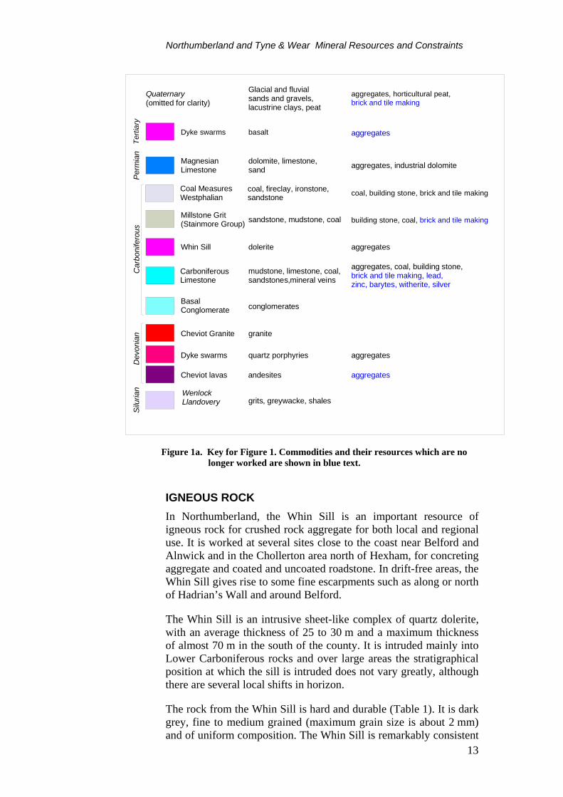
Figure 1a. Key for Figure 1. Commodities and their resources which are no longer worked are shown in blue text.
IGNEOUS ROCK In Northumberland, the Whin Sill is an important resource of igneous rock for crushed rock aggregate for both local and regional use. It is worked at several sites close to the coast near Belford and Alnwick and in the Chollerton area north of Hexham, for concreting aggregate and coated and uncoated roadstone. In drift-free areas, the Whin Sill gives rise to some fine escarpments such as along or north of Hadrian’s Wall and around Belford.
The Whin Sill is an intrusive sheet-like complex of quartz dolerite, with an average thickness of 25 to 30 m and a maximum thickness of almost 70 m in the south of the county. It is intruded mainly into Lower Carboniferous rocks and over large areas the stratigraphical position at which the sill is intruded does not vary greatly, although there are several local shifts in horizon.
The rock from the Whin Sill is hard and durable (Table 1). It is dark grey, fine to medium grained (maximum grain size is about 2 mm) and of uniform composition. The Whin Sill is remarkably consistent

Northumberland/Tyne & Wear Mineral Resources and Constraints
14
in character, throughout its thickness and outcrop. Adjacent to hydrothermal veins or locally along the margins of the intrusions the dolerite is sometimes altered to a white clay-carbonate rock, ‘white whin’. Locally small areas of the sill have also been deeply weathered to a mixture of clay and fractured dolerite.
Dykes of similar mineralogy, broadly trending east-north-east, are associated with the sill. The rocks immediately adjacent to the sills and dykes have been metamorphosed. Thus sandstones have been converted to quartzites, limestones to marbles and shales have been hardened.
Production of igneous rock aggregates in Northumberland was over 1.3 million tonnes in 1998 and most of this came from the Whin Sill. Rock Type Locality PSV AAV AIV ACV TFV
(kN) Rel. Den.
Water absorption(%)
Whin Sill – Dolerite Belford 56 4.6 14 15 270 2.92 1.1
Whin Sill – Dolerite Newcastle 57 3.1 10 11 375 2.95 0.8
Whin Sill – Dolerite Hexham 56 3.6 10 11 390 2.91 0.7
Felsite intrusion Rothbury 56 1.6 15 15 290 2.63 1.9
Table 1. Typical aggregate properties of igneous rocks in Northumberland
Definitions: Aggregates Abrasion Value (AAV): Resistance of an aggregate to abrasion as measured by the aggregates abrasion test. The smaller the value the more resistant the rock is to abrasion. Abrasion resistance is particularly important for road surfacing materials.
Aggregate Crushing Value (ACV): Resistance of an aggregate to crushing when subjected to a crushing force as measured by the aggregate crushing test. The smaller the value, the more resistant the rock is to crushing.
Aggregate Impact Value (AIV): Resistance of an aggregate to repeated impact as measured by the aggregate impact test. The smaller the value, the more resistant the rock is to impact.
Polished Stone Value (PSV): Resistance of an aggregate to polishing as measured in the accelerated polishing test. A measurement of skid resistance on road surfaces. The larger the value the more resistant the rock is to polishing.
Ten Percent Fines Value (TFV): Resistance of an aggregate to crushing as measured by the force in kN applied in the ten percent fines values test. The larger the value, the more resistant the rock is to crushing.
Intrusive and extrusive igneous rocks are also associated with the Cheviot Igneous Complex which is of Devonian age. The core of the Cheviot Hills is formed of the Cheviot Granite, the surface outcrop of which occupies an area of some 70 km2. The granite is surrounded by volcanic (extrusive) rocks consisting of mainly of

Northumberland and Tyne & Wear Mineral Resources and Constraints
15
andesitic and rhyolitic lavas. The igneous complex is deeply weathered and altered and forms a remote, upland massif characterised by rounded features. The potential of both the granite and the volcanic rocks as a source of aggregate is thought to be low and consequently they are not shown on the mineral resources map. However, a small intrusion of felsite in the complex is worked at Harden Quarry near Rothbury for the production of a range of aggregate products which are valued for their red colour.
LIMESTONE Rocks of Carboniferous age underlie most of Northumberland and the Carboniferous Limestone (Lower Carboniferous) covers large parts of the county. In other areas of England and Wales the Carboniferous Limestone is the major source of limestone raw materials for aggregates, cement and industrial use. In Northumberland rocks of this age consist predominantly of cyclical sequences of mudstone, sandstone, limestone and coal. The limestones are thin and tend to be argillaceous (muddy) with shale partings. The Carboniferous Limestone sequence of Northumberland is, therefore, not generally considered to be a limestone resource and is not shown on the map. Locally, however, limestones which are closely associated with the Whin Sill have been thermally altered to a calc-silicate hornfels adjacent to the Whin Sill, and are worked at Barrasford in conjunction with the Whin Sill. Also shown are the Scar and Robinson limestones in the extreme west of Northumberland.
However, the basal limestone, the ‘Great Limestone’, of the overlying Namurian (Upper Carboniferous) sediments is sufficiently thick, extensive and consistent in quality to form a workable resource. The Great Limestone consists of well bedded, mid to dark grey, bioclastic limestones with thin mudstone partings. It is generally between 8–20 m in thickness. Locally, the uppermost 5 m or so of strata contain interbeds of shale and calcareous mudstone (the Tumbler Beds). The Great Limestone is currently worked at three sites in southern parts of the county, where it is quarried for crushed rock aggregates. It produces a relatively strong and durable crushed rock aggregate suitable for roadstone (although not wearing course material) and construction fill. The Carboniferous limestones are of moderate chemical purity and contain around 6 per cent impurities. They are therefore not sufficiently pure to be used as industrial- (chemical-) grade limestones.
Dolomites, dolomitic limestones and limestones of Permian age (the Magnesian Limestone) occur in the southeast corner of South Tyneside. These rocks, which have a complex geology, mineralogy and chemistry, form the northernmost part of a narrow, easterly dipping outcrop which extends from Newcastle to Nottingham. The Magnesian Limestone is highly variable in its physical, mechanical and chemical properties, and thus in its suitability for particular

Northumberland/Tyne & Wear Mineral Resources and Constraints
16
applications. Most of the dolomites or limestones are of low chemical quality and are relatively soft and porous. They are generally only suitable for less demanding aggregate usage. Within the area, only Marsden Quarry in South Shields is in operation working dolomites and limestones from the Upper Magnesian Limestone for roadstone, fill and agricultural use.
‘Traditional’ nomenclature Revised nomenclature Thickness (m)
⎧ Seaham Formation 32Upper Magnesian Limestone ⎨ Roker Dolomite 46 | Concretionary Limestone 110 ⎩ Formation
Middle Magnesian Limestone Ford Formation 80
Lower Magnesian Limestone Raisby Formation 49
Table 2. Simplified stratigraphy of the Permian Magnesian Limestone in South Tyneside
The Magnesian Limestone is traditionally divided into three formations and Table 6 shows how this nomenclature relates to modern lithostratigraphic terminology. In South Tyneside, all formations from the Magnesian Limestone are capable of producing aggregates suitable for sub-base roadstone and fill. Toward the top of the sequence, the better quality Concretionary Limestone occurs. This is a relatively hard, crystalline limestone and is capable of producing higher grades of aggregate materials suitable for roadbase usage or even concreting aggregates.
Locality PSV AAV AIV ACV TFV (kN)
Rel. Den.
Water absorption(%)
South Shields - - 53 38 50 2.84 3.4
Table 3. Typical aggregate properties of Concretionary Limestone Formation in South Tyneside
Concretionary Lst (South Shields)
Concretionary Lst (South Shields)
wt %
CaO 50.94 30.85
MgO 4.51 19.95
SiO2 0.00 1.40
Fe2O3 0.16 0.46
Al2O3 0.00 0.19
Table 4. Chemical analyses of the Permian Magnesian Limestone of South Tyneside (from Harrison, 1990)

Northumberland and Tyne & Wear Mineral Resources and Constraints
17
SAND AND GRAVEL Some 1.4 million tonnes of sand and gravel was produced in the area in 1998. Production of sand and gravel since 1979 for Northumberland, and Tyne and Wear is shown in Figures 2a and 2b respectively. All the production is derived from superficial or ‘drift’ deposits comprising glacial sand and gravel, and river sand and gravel. Although bedrock resources in the form of the Permian Basal Sands have a small outcrop in the extreme south-east of the area, they are currently unworked.
The variability of sand and gravel deposits together with their possible concealment within or beneath till (boulder clay) means that, in comparison with other bulk minerals, it is more difficult to infer the location and likely extent of potentially workable resources from geological maps. The properties which influence the economic potential of a sand and gravel deposit include:
• Sand to gravel ratio
• Proportion of fines and oversize material
• Presence of deleterious rock types (such as coal or mudstone)
• Thickness of deposit and overburden ratio
• Position of the water table
• Possible presence of unwanted interbedded material
• The ease with which material can be processed to produce a saleable product (clay fines are more difficult to remove than silt)
• Location relative to demand The distribution of sand and gravel shown on the maps can generally be considered as being at the inferred resource level. BGS sand and gravel assessment surveys undertaken in the Tyne Valley around Blaydon (Giles, 1981) and Hexham (Lovell, 1981), have upgraded the data in these areas to the level of ‘indicated’ resources. Additionally, a desk study of sand and gravel resources with limited field checking was carried out around Wooler (Jackson, 1984). These areas are clearly indicated and include the category ‘concealed glacial and river sand and gravel’ not shown elsewhere on the maps. In the Morpeth–Bedlington district, areas were delineated on the proportion of overburden within boreholes, no further study was undertaken (Jackson and Lawrence, 1990). The physical criteria used by BGS to define indicated ‘potentially workable’ sand and gravel resources are set out in Table 5.

Northumberland/Tyne & Wear Mineral Resources and Constraints
18
0
500
1000
1500
2000
2500
3000
3500
1979 1980 1981 1982 1983 1984 1985 1986 1987 1988 1989 1990 1991 1992 1993 1994 1995 1996 1997 1998Year
Thousand tonnes
Sand & gravel
Crushed rock
Figure 2a. Production of sand and gravel and crushed rock aggregate in Northumberland 1979 – 1998. Missing data withheld to protect commercial confidentiality. Source: Annual Minerals Raised Inquiry, Office for National Statistics.
0
200
400
600
800
1000
1200
1400
1600
1800
1979 1980 1981 1982 1983 1984 1985 1986 1987 1988 1989 1990 1991 1992 1993 1994 1995 1996 1997 1998
Year
Thousand tonnes
Sand & gravel
Crushed rock
na na
Figure 2b. Production of sand and gravel and crushed rock aggregate in Tyne and Wear 1979 – 1998. Missing data withheld to protect commercial confidentiality. Figures include marine dredged material. Source: Annual Minerals Raised Inquiry, Office for National Statistics.

Northumberland and Tyne & Wear Mineral Resources and Constraints
19
Superficial deposits Superficial deposits comprise all those sediments laid down during the last two million years. For the purpose of this report these materials have been divided into four groups:
• River sand and gravel
• Glacial sand and gravel
• Blown sand and beach deposits.
• Marine and estuarine alluvium
BGS Mineral assessment reports
Deposit thickness >1 m
Overburden: sand and gravel ratio 3:1
Sieve size for which the proportion of fines passing should not exceed 40 %
0.0625 mm
Proximity of deposit to surface 25 m
Table 5. Resource criteria for ‘potentially workable’ sand and gravel resources to be indicated
River sand and gravel River sand and gravel includes post-glacial river terrace deposits, alluvial deposits and fluvioglacial deposits. The post-glacial river terrace deposits and alluvial deposits are developed along the major river valleys. River sand and gravel is extracted at several locations in the area in the valleys of the river Breamish, Tyne, Coquet and Till.
Fluvioglacial deposits are included in this category as they tend to occur beneath river terraces, as well as underlying flood plain deposits (alluvium) and may be difficult to distinguish or, on older maps, undifferentiated. In general it is not possible to distinguish between alluvial sand and gravel and the terrace deposits in boreholes. Sand and gravel quarrying operations based in river valleys will generally work both alluvial and underlying fluvioglacial deposits where present.
Fluvioglacial sands and gravels deposits are derived from the glacial deposits and have been partially, but imperfectly, sorted by streams issuing from the melting glaciers which transported debris down the main valleys. The largest spread of such deposits in North-East England is in north Northumberland near Wooler where extensive terraces of sand and gravel up to 9 m in thickness occur (Jackson, 1984). Large deposits also occur in the valleys of the River Tyne and its tributaries. The deposits tend to be more regular both in depth and composition than the glacial material and tend to contain a higher proportion of gravel. The thickness of river sand and gravel

Northumberland/Tyne & Wear Mineral Resources and Constraints
20
in the Tyne valley between Hexham and the western outskirts of Newcastle averages between 6 and 10 m (Lovell, 1981; Giles, 1981).
Glacial sands and gravels These form the largest group of sands and gravels found in North-East England. They are ice-contact sediments laid down by streams flowing on the tops of, within and beneath ice sheets. These deposits are commonly associated with till (boulder clay) and may occur as lenses either within or beneath the till. The essential feature of these deposits, critical in terms of their economic value, is their wide lateral and vertical variation in thickness and composition. Individual deposits can be up to 20 m thick. The deposits are mainly derived from local rocks with the addition of some erratics, and are characteristically ‘dirty’. They are often contaminated with coal, as well as varying amounts of clay and silt. The nature of any one deposit depends very much on local conditions at time of deposition. Pebble shape varies considerably. Some gravels may be water worn and well rounded, but more usually the glacial material contains a high proportion of flaky particles which may reduce economic value.
Area Fines % (<0.063 mm)
Sand % (0.063-4 mm
Gravel % (>4 mm)
Alluvium & river terrace Blaydon 9 40 51 Hexham 8 53 39 Glacial sand and gravel Blaydon 23 63 14 Hexham 12 56 32
Table 6. Mean grading data for sand and gravel in those parts of the district covered by BGS surveys.
Beach sand and blown sand Beach sands are found along the length of the Northumberland coast and are often backed by sand dunes. The area of beach worked usually lies between low water mark to within about 20 m of the dunes. The material is generally clean fine- and medium-grained sand and of uniform grading. Material formerly worked at Druridge Bay was removed for use as a concreting and building sand. No beach deposits are currently worked.
Blown or dune sands are of variable thickness. The deposit consists of uncemented sand composed of fine- to medium-grained subangular to rounded, commonly polished, quartz grains. Shell fragments and organic remains may be present. Blown sand is not worked at present in this area. Considerable areas of dunes are designated as SSSIs which will limit their potential.

Northumberland and Tyne & Wear Mineral Resources and Constraints
21
Marine and estuarine alluvium Within the Morpeth area, these resources occur in the estuaries of the Blyth and Wansbeck, where they consist of silt, pebbly clay and sand and gravel, in the latter location, they can be up to 11 m thick. They are not worked at present.
Bedrock deposits
Basal Permian Sands The bedrock sand resource is confined to the Basal Permian Sands which underlie the Magnesian Limestone in South Tyneside and Sunderland. The Permian Basal Sands crop out intermittently along the base of the Magnesian Limestone escarpment and dip to the east beneath the limestone. They consist mainly of weakly cemented, yellow, fine to medium-grained, well-sorted sands of wind blown origin. Although they are not currently worked in the area, they comprise a resource of fine aggregate and are worked in County Durham as a source of building sand, with some also being used as asphalting sand.
The sands occur in west-south-west to east-north-east trending ridges, which crop out along the base of the Magnesian Limestone escarpment and which continue beneath the limestone for some distance. These ridges are between one to two kilometres wide with sand thicknesses of up to 35 m and are separated by belts where the sands are thin or absent. Sand resources are thus contained entirely within the ridges.
COAL Coal-bearing strata occur at a number of horizons in Northumberland in rocks of both Lower Carboniferous (Dinantian) and Upper Carboniferous (Namurian and Westphalian) age. The most important are the Westphalian Coal Measures of the Northumberland Coalfield, from which large tonnages of both deep-mined and opencast coal have been extracted. The Northumberland Coalfield extends from Amble in the north southwards to the River Tyne, which forms the northern edge of the Durham coalfield. The coal-bearing strata generally dip gently to the east and extend beneath the sea. A number of small outliers of Coal Measures occur along the Tyne Valley to the west of the main coalfield. Groups of generally thin and widely-spaced coal seams, separated by barren strata, also occur lower in the Carboniferous succession in the north and west of the county. Some of these have been worked on a modest scale by both opencast and underground mining. A generalized vertical section showing the relationship of the stratigraphy of coal resources is given in Figure 3.
The Northumberland and Durham Coalfield has the longest history of any in the country, and was the earliest perhaps to respond to the possibilities of an export market for coal. The monks of Tynemouth

Northumberland/Tyne & Wear Mineral Resources and Constraints
22
Priory were working and shipping coals from Tynemouth as early as 1296. Today deep mining has almost ceased and is unlikely to start again as all the thick seams have been exhausted. Only three underground mines survive, Ellington Colliery, which is located on the coast and extracts coals offshore, Wrytree/Blenkinsopp Drift, near Haltwhistle and the small Ayle Colliery, near Alston. The Coal Measures accounts for all the opencast coal output in the county, which amounted to 2.0 million tonnes in 1999/00, and a major proportion of deep-mined production. Statistics for opencast coal output in Northumberland and in Tyne and Wear are shown on Figures 7a and 7b.
The Northumberland Coalfield is one of the major sources of opencast coal in Britain and four sites were in operation in the area in March 2000. Opencast sites in the Northumberland Coalfield are generally larger than elsewhere. For example, the Stobswood site near Morpeth has an output of some 1 million tonnes a year. Opencast coal generally has lower chlorine contents than deep-mined coal, and values for Northumberland are typically in the range 0.02–0.05 per cent Cl. The sulphur content of Northumberland opencast coals are in the range 1.2–1.7 per cent S.
The opencast coal resources defined on the accompanying Mineral Resources Map are divided into two broad categories:
• a principal resource area comprising closely-spaced coals within the Coal Measures;
• a subsidiary resource area consisting of much more widely-spaced coals (higher in the Coal Measures and also in the Lower Carboniferous)
The stratigraphical distribution of these resource areas is shown in Figure 2.
Current opencast activity is confined to the exposed Lower and Middle Coal Measures, the main target for opencast coal extraction being between the Bottom Marshall Green and the High Main Coals (Figure 3). This is shown as the ‘principal resource area’ on the maps. Although the crop of the High Main Coal has been used to define the top of the principal opencast resource area, coal seams higher in the succession such as the Moorland and Bottom Ryhope Five Quarter (Figure 3) are also worked locally. These are included within the ‘subsidiary resource area’ shown on the maps. Depending on overburden ratios, the High Main may also be worked some distance to the east of its crop, particularly in the north. Where the Bottom Marshall Green Coal is not mapped in the north, the Brockwell Coal has been used. Small areas of locally-workable coal have been extracted below the Bottom Marshall Green.

Northumberland and Tyne & Wear Mineral Resources and Constraints
23
Aegiranum Marine Band
Ryhope CoalsMoorland
Maltby Marine BandHigh MainMetalFive-QuarterYard
Durham Low MainNorthumberland Low Main
Vanderbeckei Marine BandBeaumont
Busty
BrockwellVictoria
Marshall Green
Subcrenatum Marine Band
Great LimestoneTownhead
Shilbottle
Oxford Limestone
Woodend
Dun Limestone
Fawcet
Scremerston Main
Wester
Mid
dle
Coa
l Mea
sure
sLo
wer
Coa
l Mea
sure
sM
illst
one
Grit
Upp
er L
imes
tone
Gro
upM
iddl
e Li
mes
tone
Gro
upLo
wer
Lim
esto
ne G
roup
Scre
mer
ston
Coa
l Gro
up
Metres
100
200
300
0
Little Limestone CoalLittle Limestone
M M
M M
M M
M M
mudstone/siltstonesandstone
OPENCAST COAL RESOURCES
Principal resource area - thick, closely spaced coalsSubsidiary resource area - widely spaced coals
limestoneTilley
Plashetts
Figure 3. Generalised vertical section of the Northumberland Coalfield, showing shallow coal resource definitions

Northumberland/Tyne & Wear Mineral Resources and Constraints
24
0
500
1000
1500
2000
2500
3000
86/87 87/88 88/89 89/90 90/91 91/92 92/93 93/94 94/95 95/96 96/97 97/98 98/99 99/00
Financial year (1st April - 31st March)
Thousand tonnes
Figure 4a. Opencast coal output in Northumberland by financial year
0
50
100
150
200
250
300
350
400
450
86/87 87/88 88/89 89/90 90/91 91/92 92/93 93/94 94/95 95/96 96/97 97/98 98/99 99/00Financial year (1st April - 31st March)
Thousand tonnes
na na
Figure 4b. Opencast coal output in Tyne and Wear by financial year
Source for Figure 3a and 3b: Opencast Mining Statistics, County Planning Officers Society and the Coal Authority
Northumberland and Tyne & Wear Mineral Resources and Constraints
25
West of the main coalfield there are outliers of Coal Measures strata preserved on the downthrow side of the Stublick Fault. Several seams have been worked by underground mining in the past and some coal has been worked opencast in recent years. The coalfields are, from west to east: the Midgeholme Coalfield, the Plenmeller Coalfield, and the Stublick Coalfield. The Midgeholme Coalfield, the largest, lies partly within Cumbria. The Plenmeller Coalfield contains some 100 m of Lower Coal Measures, including nine coal seams. The whole area has recently been opencasted but coaling operations ceased in 1998. The Stublick Coalfield also contains some 100 m of Lower Coal Measures including eight coals.
Coals lower in the Carboniferous succession occur at a number of different horizons (Figure 3). The most important are the Shilbottle Coal in the Middle Limestone Group and the Little Limestone Coal in the Upper Limestone Group. These are included in the subsidiary resource area shown on the maps. The Shilbottle Coal was formerly worked at the Whittle mine near Newton-on-the-Moor. Some 230 000 t/y of high sulphur is mined from the Little Limestone Coal at the combined Wrytree and Blenkinsopp Drift mines near Greenhead. There are no major production constraints on sustaining this level of output for several decades. The Little Limestone Coal is also worked on a very small scale at Ayle Colliery near Alston, and, until recently, at Barhaugh Colliery.
The Scremerston Coal Group, containing widely spaced coal seams up to 2 m thick, has supported small-scale production in the past in north Northumberland and the North Tyne valley but is not currently worked. The seams are laterally variable, but in general tend to be soft, pyritous and high in ash with persistent dirt bands. They are included in the subsidiary resource area shown on the maps. The thicker, cleaner coals, such as the Plashetts seam formerly worked at Black Belling Mine, Falstone and the Scremerston Main (or Blackhill) at Scremerston may have been worked out. Even where worked the coals were generally not of high quality, the sulphur content of the Plashetts seam, for example, averaging over 2.8 per cent. The last opencast site on the Scremerston Coal Group (Jacks Law) closed in 1993.
A very minor production of coal comes from beach deposits. This represents either coal that has been eroded from underwater exposures of coal seams, or coal that has been separated by the sea from the extensive offshore tipping operations once carried out by coastal collieries and washed ashore. The coal is taken from beaches, often by horse and cart, before processing. Coal washing of material in old colliery tips is a further minor potential source but there are no current operations in progress. The operation is usually in concert with restoration of derelict land.

Northumberland/Tyne & Wear Mineral Resources and Constraints
26
Areas of opencast coal extraction The Coal Authority is a non-departmental public body which was established by the Coal Industry Act 1994. On 31st October 1994 it assumed responsibility for all the interests previously vested in British Coal in respect of unworked coal and coal mines and for the liabilities associated with past coal mining and unworked coal. The main functions of the Authority are to manage the coal resources under its control, encourage economically viable operations to work these resources, grant licences for coal exploration and extraction, provide effective management of subsidence damage claims, and provide information on past, present and proposed future coal mining activities.
For active sites, the extent of the licence area for coal extraction issued by the Coal Authority is shown. Both opencast and deep mine licences are shown on the map. Areas of extracted opencast coal are shown on the map, although these data may not be completely up-to-date. The Coal Authority’s mining reports database contains information on past opencast coal mining activity, which is an aggregate of information derived from a number of sources. The areas shown on the map mainly reflect the limits of coal extraction. However, the recent entries into the mining reports database principally reflect site boundaries. More detailed information on specific sites may be obtained from the Coal Authority or the relevant minerals planning authority.
The extensive nature of these former opencast coal sites does not imply that the coal resource has been exhausted. The economics of coal extraction have changed with time, allowing coals with higher overburden ratios to be extracted. Some sites, or parts of sites, have been worked on more than one occasion and may be worked for deeper coal in the future. However, modern sites worked within the last 25 years are likely to have exhausted the economically recoverable coal resources. Extensive areas of the coalfield have been worked by deep mining but these are not shown on the map. This information may be obtained from the Coal Authority.
CLAY AND SHALE Clay and shale are used mainly in the manufacture of structural clay products, such as facing and engineering bricks, pavers, clay tiles and vitrified clay pipes. Brick manufacture is the largest tonnage use. Clays may also be used as a source of constructional fill and for lining and sealing landfill sites. The suitability of a clay for the manufacture of structural clay products depends principally on its behaviour during shaping, drying and, most importantly, firing. This behaviour will dictate the final properties of the fired product, including its strength, porosity (water absorption), durability and aesthetic qualities.
Northumberland and Tyne & Wear Mineral Resources and Constraints
27
Small brickworks mainly producing 'common' bricks from locally won raw materials were formerly a common feature in many industrial areas of Britain. However, in the last two or three decades there has been a major rationalisation of the brick industry which is now based on a small number of plants operated by a limited number of companies. With the demise of the 'common' brick, the main products are now high-quality facing bricks, engineering bricks and related products such as clay pavers. Modern brickmaking technology is highly automated and requires high capital investment. It is increasingly dependent, therefore, on raw materials with predictable and consistent firing characteristics in order to achieve high yields of saleable products, and to reduce waste both in the quarry and plant. Blending different clays to achieve improved durability and to provide a range of fired colours and aesthetic qualities is an increasingly common feature of the brick industry. Continuity of supply of consistent raw materials is of paramount importance.
Bricks are produced in three locations in the area covered by the map. The large plant at Throckley, west of Newcastle in unusual in that it has no captive pit. Clays which fire to a red colour are imported from Red Barns Quarry at Wardley on South Tyneside which is 22 km from Throckley. Two seams of mudstone separated by a sandstone are worked in the quarry, which is in Middle Coal Measures. When blended, these mudstones meet specifications such as fired colour, shrinkage and carbon content (<1 per cent) which are set by the plant. Throckley also imports fireclay from a number of opencast coal sites in the Morpeth area. The fireclays are blended in varying proportions with the Coal Measure mudstones to produce a range of buff-coloured facing bricks. The plant also produces a variety of red facing bricks using the Coal Measure mudstones only. All bricks are produced using the extrusion process. Most bricks produced at Throckley go to local markets in the North East of England, although a significant proportion is sold into the Scottish market.
A relatively small brick production plant operates at Swarland Brickworks, Thrunton, near Rothbury. The plant produces red facing and common bricks from glacial clays using the extrusion process. These are extracted from a pit adjacent to the brickworks. A plant at Stobswood, north of Morpeth, has recently closed, but formerly produced a range of buff facing bricks from fireclays extracted from opencast coal operations in the Morpeth area, as well as fireclays imported from Scotland. A range of fireclay-based bricks for specialised refractory applications were also produced at Stobswood.
FIRECLAY Fireclays are non-marine mudstones and occur as seatearths (or fossil soils) underlying almost all coal seams and represent the soil on which coal-forming vegetation once flourished. Resources are, thus,
Northumberland/Tyne & Wear Mineral Resources and Constraints
28
mainly confined to coal-bearing strata. Fireclays typically consist of comparatively thin (usually <1.0 m), unbedded mudstones with rootlets. There is no correlation between coal seam thickness and the properties and thickness of a fireclay.
The term ‘fireclay’ is now used to describe seatearths which are of economic interest. Originally fireclays were valued as refractory raw materials, because of their relatively high alumina and low alkali contents. Demand for fireclay for refractory use has, however, declined markedly since the late 1950s. This is mainly due to changing technology in the iron and steel industry where more severe operating conditions now require much higher quality refractories. Only very small quantities of fireclay are now used for refractory applications. However, some fireclays have relatively low iron contents compared with other brickmaking clays and they are now valued for the production of buff-coloured facing bricks and pavers. They are often blended with red-firing brick clays to produce a range of fired colours.
Fireclays exhibit a wide range of mineralogical compositions and properties, both in terms of their vitrification characteristics and fired colour, the latter being largely a function of iron content. They consist essentially of the clay minerals kaolinite and hydrous mica, together with fine-grained quartz in varying proportions. Typically these three minerals make up some 90 per cent of the rock. Seatearths include all grades of sediment from mudstone (seatclay) to sandstone (ganister). Ganisters, or high silica sandstones, are comparatively rare. Clay-rich seatearths, (seatclays), are much more common but may exhibit rapid vertical and lateral variations in composition and thus properties All are contaminated to a greater or lesser extent by impurities which render part, or the whole, of a seam unusable. Siderite, present as both clay ironstone nodules of variable size and sphaerosiderite less than 1 mm in diameter, and carbonaceous matter, present as coaly matter and fossil debris, are common constituents. They may represent serious impurities in commercial fireclays and restrict their use. Pyrite, which is often associated with carbonaceous material, may also be present as an impurity. In addition to carbon and sulphur, which should normally be less than 1.5 per cent and 0.1 per cent respectively, fired colour is the main criterion on which the suitability of a fireclay is judged for facing brick manufacture. Iron oxide contents should normally be less than 2.5 to 3.0 per cent Fe2O3 and on firing the fireclay should give a uniform buff/cream colour. However, depending on how the iron occurs, higher iron contents may be tolerated. The majority of seatearths are unsuitable for use, and fireclay production is localised both geographically and geologically.
The close association of fireclay and coal means that opencast coal sites provide one of the few viable sources of fireclay from which they are recovered as a by-product. Fireclay resources are thus essentially coincident with shallow coal resources. However, only a small

Northumberland and Tyne & Wear Mineral Resources and Constraints
29
proportion of opencast coal sites normally produce fireclay. This may be due to the variable quality of fireclays, or may be a result of operational or planning restrictions. The size and speed of opencast mining invariably creates a mismatch between potential fireclay supply and immediate market demand. Unless marketable fireclays can be stockpiled , either on or off site, they are usually backfilled with overburden and irrecoverably lost.
There are considerable opencast coal resources in the area. The potential for fireclay extraction is considerable, but is dependent on their quality and thickness. The principal areas of interest in the Northumberland coalfield for fireclays for use in the brick industry are seams in the Lower Coal Measures. Seams such as Beaumont, Tilley, Busty and Brockwell are, or have been, worked in the Morpeth area for fireclay as well as coal. These sites fall within the ‘principal resource area’ for opencast coal which is identified on the map.
Although there is variation, relatively high Al:Si ratios in Northumberland fireclays tend to make them more refractory than other fireclays from England. This refractory nature is reflected in the relatively high firing temperatures (>1100ºC) used to produce acceptable quality bricks. However, despite the increased costs that high firing temperatures incur, demand for Northumberland fireclays is strong because of their excellent fired colour. The brick industry consumed 94 000 tonnes of Northumberland fireclays in 1998. The bulk of this material was used at brick plants in the North East (see above), although a considerable portion was transported to Lancashire. Markets are also now developing for Northumberland fireclay at brick plants in Yorkshire.
SANDSTONE Sandstones are bedded sedimentary rocks formed from the weathering and decomposition of pre-existing rock-types. They are present in strata of all geological periods and are economically important as sources for aggregate, building sand, silica sand and building stone. Sandstones are defined as sedimentary rocks composed of silicate mineral grains that lie in the size range 0.063–2 mm and are described as fine-, medium- or coarse-grained within these limits.
Good building sandstones demonstrate two principal characteristics:
• a durable mineralogical framework of detrital grains, most commonly, sand-sized quartz and feldspar.
• resistant natural intergranular mineral cements including silica, various carbonates and clay minerals, which rigidly bind the grain framework together.

Northumberland/Tyne & Wear Mineral Resources and Constraints
30
In the selection of a sandstone for building purposes, other parameters considered include colour, porosity and bed thickness. For example, sandstones with low porosity values are generally better suited to withstand the effects of constant wetting, drying and/or freezing caused by water penetration during the weathering cycle. In some cases, the presence of mica flakes in laminae will allow splitting of the sandstone to make roofing or paving slabs. At present there is only one quarry in Northumberland, Ladycross, where this type of material is produced.
The recognition of the quality of sandstones in Northumberland and Tyne & Wear for building purposes dates back to Roman times. This is evident from its use in extensive sections of Hadrian’s Wall and its Milecastles. By the 12th century, quarries were supplying sandstone for the Norman Castle Keep in Newcastle. The city walls of Newcastle and their defensive towers were constructed of local sandstones from the 13th century onwards. Also during medieval times, church buildings (churches, abbeys, priories) were almost exclusively constructed of locally-quarried Carboniferous sandstones.
Quarry Location National Grid
Reference
Coal Measures Heddon Heddon-on-the-Wall NZ 130 668 Woodhorn Woodhorn NZ 290 880 Ashington Blyth NZ 260 870 Bedlington Morpeth NZ 263 809 Byker Newcastle NZ 270 630 Elswick Newcastle NZ 220 630 Windy Nook nr. Gateshead NZ 250 620 Kenton Newcastle NZ 220 675 Heworth Gateshead NZ 285 616 Stainmore Group Black Pasture Chollerford NY 931 698
Carboniferous Limestone Cementstone Group Greenlaw Yetlington NU 020 090 Burradon Killingworth NZ 280 710 Fell Sandstone Pondicherry nr Rothbury NU 040 010Lower Limestone Group Woodburn or Blaxter nr Bellingham NY 899 858 Middle Limestone Group Prudham Fourstones, nr. Hexham NY 886 689 Denwick Denwick NU 210 146
Table 7 Major 19th century building sandstone quarries. After (Hunt 1860; Crane 1979).
The modern building sandstone industry is, however, largely a product of Britain’s industrial revolution. Peak production was from the 19th to the early part of the 20th century. Throughout most of this period, a large number of quarries were actively supplying
Northumberland and Tyne & Wear Mineral Resources and Constraints
31
sandstone for public buildings, industrial constructions (such as railway bridges and docks) and housing in cities and towns county-wide.
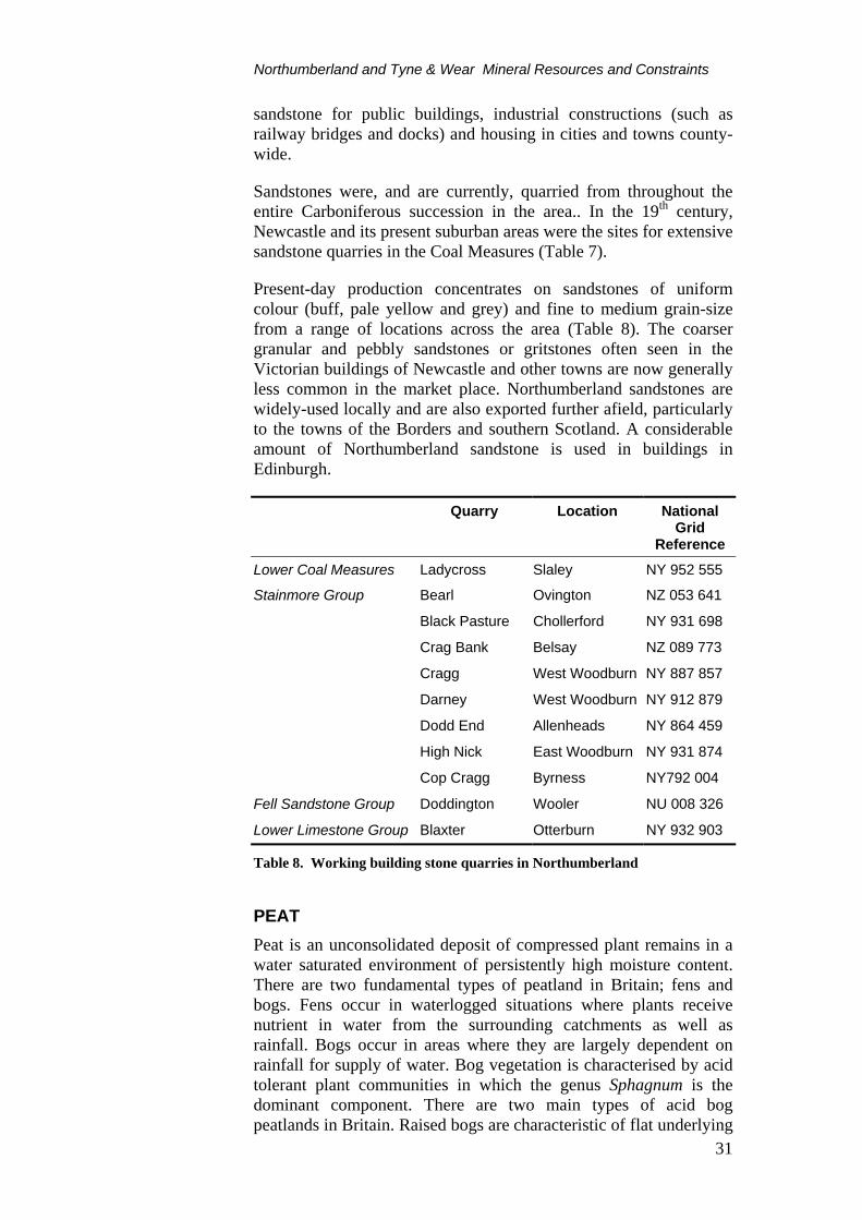
Sandstones were, and are currently, quarried from throughout the entire Carboniferous succession in the area.. In the 19th century, Newcastle and its present suburban areas were the sites for extensive sandstone quarries in the Coal Measures (Table 7).
Present-day production concentrates on sandstones of uniform colour (buff, pale yellow and grey) and fine to medium grain-size from a range of locations across the area (Table 8). The coarser granular and pebbly sandstones or gritstones often seen in the Victorian buildings of Newcastle and other towns are now generally less common in the market place. Northumberland sandstones are widely-used locally and are also exported further afield, particularly to the towns of the Borders and southern Scotland. A considerable amount of Northumberland sandstone is used in buildings in Edinburgh.
Quarry Location National Grid
Reference
Lower Coal Measures Ladycross Slaley NY 952 555
Stainmore Group Bearl Ovington NZ 053 641
Black Pasture Chollerford NY 931 698
Crag Bank Belsay NZ 089 773
Cragg West Woodburn NY 887 857
Darney West Woodburn NY 912 879
Dodd End Allenheads NY 864 459
High Nick East Woodburn NY 931 874
Cop Cragg Byrness NY792 004
Fell Sandstone Group Doddington Wooler NU 008 326
Lower Limestone Group Blaxter Otterburn NY 932 903
Table 8. Working building stone quarries in Northumberland
PEAT Peat is an unconsolidated deposit of compressed plant remains in a water saturated environment of persistently high moisture content. There are two fundamental types of peatland in Britain; fens and bogs. Fens occur in waterlogged situations where plants receive nutrient in water from the surrounding catchments as well as rainfall. Bogs occur in areas where they are largely dependent on rainfall for supply of water. Bog vegetation is characterised by acid tolerant plant communities in which the genus Sphagnum is the dominant component. There are two main types of acid bog peatlands in Britain. Raised bogs are characteristic of flat underlying

Northumberland/Tyne & Wear Mineral Resources and Constraints
32
topography and so are found mainly on low plains or broad valley floors. Blanket bogs occur in areas which are sufficiently cool and wet to allow the accumulation of peat on all but the steepest slopes in upland areas. These can however contain areas of raised mire and thicker areas known as valley or basin mire. A number of lowland raised bogs have been designated as sites of international and national conservation importance.
Some 98 per cut of the peat extracted in Britain is used as a growing media by amateur and professional gardeners.
Peat is extracted by mechanical means from two workings in Northumberland, peat being cut in summer and harvested in winter. Kemping Moss, near Lowick, is a raised mire with 25 ha permitted for extraction, the peat is sold for horticultural purposes. Greymare Farm, near Belford working lowland peat bog has 9 ha permitted. A third area, not currently worked, Bellcrag Flow, near Wark Forest in the National Park, is an area of upland raised bog.
HYDROCARBONS
Conventional hydrocarbons Northumberland contains a major Carboniferous sedimentary basin; the Northumberland Trough. This contains a thickness of more than 4000 m of Carboniferous strata in its deepest part. Source rocks with gas-generating potential occur within the Northumberland Basin, although the potential for oil generation is much less certain. Much of the succession has organic maturity which is within the oil ‘window’, although it is suggested that this maturity may have developed initially in Upper Carboniferous times and that any oil or gas generated has been lost subsequently. Generally low porosity values for sandstones within the Northumberland Basin indicate that their potential as hydrocarbon reservoir rocks is limited.
Three well have been drilled in Northumberland to test for potential. All these wells were plugged and abandoned as dry holes. Despite generally poor prospects for finding hydrocarbon resources, there is likely to be sporadic exploration interest in the area in the future.
Coalbed methane Methane is one of the main by-products of the natural process of coalification, which is the low-grade metamorphism of peat through lignite to coal and anthracite. Some of this methane migrates from the source rock as it is formed and some remains within the coal bed. The recovery of coalbed methane involves entering the coal by boreholes, then fracturing and depressurising the coal bed to facilitate desorption and degassing of the methane.

Northumberland and Tyne & Wear Mineral Resources and Constraints
33
Methane contents of seams in the Northumberland coalfield increase from less than 1 m3/t in the north near Amble, to about 3.5 m3/t in the region of Westoe and Wearmouth. Most commercially-extracted coalbed methane comes from seams with more than 7 m3/t of coal. These low gas contents, along with intensive past conventional working of coal, make the Northumberland coalfield unattractive for coalbed methane exploitation.
The outlier coalfields in the west of the county are not considered prospective for coalbed methane. A similar situation prevails in the coal-bearing strata lower in the Carbonferous succession. Coal seams in the Millstone Grit, Limestone Coal groups and Scremerston Coal Group are considered to be too thin and/or shallow to form prospects for coalbed methane.
SECONDARY AGGREGATES The term ‘secondary aggregates’ is used to describe a range of materials which may be used as alternatives to primary aggregates (subject to considerations of quality and contamination), but which arise as wastes from a variety of activities. These may be considered under three main headings:
• Naturally-occurring materials arising from mineral extraction and processing operations, such as colliery spoil, overburden and quarry/processing waste
• Materials arising from industrial processes, such as slags and ash, which may be of variable composition
• Construction and demolition wastes which may be either in a natural or manufactured state and include asphalt planings, road sub-base, concrete rubble and masonry. These materials are excluded from this study as their arisings are highly variable in location, type and duration.
Utilising the aggregate potential of such materials may have the advantage of both reducing the demand for primary aggregates and thus land for extraction, and the problems of disposing of waste. In general, however, secondary aggregates are only suitable for less demanding aggregate applications, and their production and use may not always be environmentally or economically desirable. There are limited resources of secondary aggregates in Northumberland and Tyne & Wear.
Ash All coals contain inorganic mineral matter, consisting mainly of silica and alumina derived from the mudstone and siltstone associated with coal seams. Coal-fired power stations burn pulverised coal as fuel and the main residue is a fine-grained powder called Pulverised Fuel Ash, or PFA. It is extracted from the flue gases by electrostatic and mechanical techniques and consists

Northumberland/Tyne & Wear Mineral Resources and Constraints
34
predominantly of glassy, spherical aluminosilicate particles with a size distribution in the range 2–100 μm. Typically PFA accounts for some 80 per cent of all the ash produced at power stations. The remainder is produced by the agglomeration of hot ash particles which fall to the bottom of the furnace where they are collected. This material is know as Furnace Bottom Ash (FBA) and is much coarser than PFA. FBA is a valuable material used mainly in the manufacture of concrete building blocks. Some 2 per cent of PFA consists of cenospheres, which are hard shelled, hollow, minute spheres ranging from sub-micron to millimeters in size and exhibiting very low densities. Their main application is as an inert filler.
PFA has both pozzolanic (cementitious) and physical properties that enhance the. perfomance of concrete and an important application is to replace some of the cement in concrete. PFA reacts with the lime formed when Portland cement hydrates to form stable calcium and aluminium hydrates. These hydrates reduce the voids within the concrete removing some of the lime and thus reducing permeability. This process improves the strength, durability, chloride and sulphate resistance of the concrete. In addition, the spherical shape of the PFA particles also acts as plasticisers and reduces the water requirement for a given workability. PFA also reacts readily with alkalis (Na2O and K2O) within the concrete and thus reduces the risks of alkali silica reactions. PFA can also be used as a hydraulic binder with natural or recycled aggregates in combination with lime for soil stabilisation and road pavements. It is also used in grouting to improve ground stability, particularly old mine workings. Its largest application is, however, as a structural fill for civil engineering work.
National Power currently operates two coal-fired power stations in Northumberland on one site at Blyth, designated as Blyth A and B, with a total generating capacity of 1068 MW. All the FBA is sold to concrete block manufacturers and the PFA is sold mainly into the fill and grout sectors. The site has a high sales to disposal ratio and surplus ash goes to an on-site mono disposal facility.
The Lynemouth coal-fired power station operated by Alcan Smelting and Power (UK) Ltd has a capacity of 390 MW. All the FBA is used for concrete block manufacture and some 50 per cent of the PFA is sold as a cement additive. Unsold PFA is mono filled in lagoons and provides a stockpile for future use.
Other materials Colliery spoil is the waste from mining and processing coal. It consists mainly of mudstone and siltstone. In Northumberland, former tips have largely been reclaimed/restored and are not now available as a source of secondary aggregate. Some colliery spoil from the Ellington colliery is sold for fill.

Northumberland and Tyne & Wear Mineral Resources and Constraints
35
METALLIFEROUS AND ASSOCIATED VEIN MINERALS Although the county contains no metalliferous mineral workings at present, historically, it has been the site of base-metal, witherite, baryte and iron mining on a substantial scale.
The south-western part of Northumberland forms part of the North Pennine Orefield (Dunham 1990). Mining took place largely around Haydon Bridge, Blanchland (Derwent Valley), between Allenheads and Allendale (East and West Allen valleys), at Settlingstones near Hexham, and across the county boundary from here into Durham and Cumbria. Mineralisation mostly comprises steeply-dipping veins filling fractures and faults with some replacement deposits (flats) in the adjacent Carbonifeous limestone host rock. Mining may go as far back as Roman times, with most lead and zinc production in the 18th and 19th centuries. The industrial minerals fluorspar, witherite and baryte, which occur in the veins with the lead and zinc ores, were originally discarded, but have been the principal minerals produced from the mines since the Second World War. The Settlingstones mine was the largest producer of witherite (BaCO3) in the world, producing 850 000 tonnes until its closure in 1969. The last mines (in Durham) closed in the late 1990s.
Figure 5. Location of Mineral Reconnaissance Programme and MEIGA Reports areas

Northumberland/Tyne & Wear Mineral Resources and Constraints
36
Total production from the North Pennine Orefield is estimated to have been over 4 million tonnes of lead ore, 300 000 tonnes of zinc ore, 2 m tonnes of fluorspar, 1 m tonnes of witherite and 1.5 m tonnes of baryte.
Bedded ironstones occur in the Carboniferous rocks. These were low grade deposits divided into clay band (clay matrix) and black-band (carbonaceous matrix) types that were worked at a number of localities including Bellingham, Redesdale and Haydon Bridge in the 18th and 19th centuries. All were of low grade even for this type of deposit, for example 20−25% Fe is quoted for the black band ironstone at Haydon Bridge (Gibson & Sherlock, 1920). Production records are incomplete, but output was relatively small (less than 1 Mt in total) and was insufficient to meet the demands of industry in the area. They are of no current economic interest.
The former widespread metalliferous mining has resulted in large volumes of mining waste, some of which has been redistributed by human activities and natural processes, notably river erosion and downstream floodplain deposition (BGS, 1996).
Mineral exploration during the last thirty years by both the private (MEIGA-sponsored) and public (DTI-sponsored Mineral Reconnaissance Programme) sectors has been low key (Figure 5). It focused on looking for extensions to the known vein and replacement style base-metal-baryte and fluorite mineralisation, assessing the likelihood of finding base-metal deposits similar to those worked economically in Ireland, and reconnaissance surveys for a number of types of mineralisation in the Cheviot Hills, including gold and uranium deposits. No major discoveries of economic-significance have been made, but some potential still exists for new mineral deposits to be found and worked economically, particularly in the north (Cheviot) and west (North Pennines) of the county.

Northumberland and Tyne & Wear Mineral Resources and Constraints
37
MINERAL RESOURCES AND PLANNING CONSTRAINTS The landscape character of Northumberland and Tyne & Wear reflects the nature and structure of the underlying rocks, the erosive forces to which they have been subjected and the soil and vegetation that they support. This character is constantly changing due to economic and social pressures in the short-term and to geomorphological processes in the long-term. Mineral extraction can cause irrevocable, but not necessarily harmful, change to a locality over a relatively short timescale. In order to ensure that such changes are sustainable, and do not harm the environment, the most valuable landscapes and habitats (such as National Parks, AONB, SSSIs) are given a greater degree of protection from mineral working. The need for mineral workings in such areas has to be justified by a most rigorous examination of the merits of the proposal. This examination considers the wider public interest in the development of the resource and the social and economic issues as well as the need to protect the environment.
Mineral extraction in areas designated as Special Protection Area (SPA) or Special Area of Conservation (SAC) may be acceptable if there are no alternatives and if there are imperative reasons of overriding public interest which support the development. For certain priority SACs, development can only be considered to be acceptable if there are overriding reasons of public health or safety or due to beneficial environmental consequences. Whilst the requirement to assess the acceptability of mineral working in designated areas is therefore stringent, there is no total prohibition on working minerals in such areas.
The resolution of conflicts between mineral resource development and other considerations is undertaken through the development plan framework and the development control system with a balanced appraisal of the issues raised. The Mineral Resource Maps of Northumberland and Tyne & Wear provide a synthesis of available information which can be revised and updated as additional data becomes available. Additional constraint designations may be incorporated as required. It is hoped that these maps and the associated report will assist local and national government, the minerals industry and other interested parties in the consideration and production of policies in development plans.
The study area contains a number of landscapes, from urbanised south east Northumberland and Tyne and Wear, through farmland in the Tyne Valley and the lowlands of Northumberland, to the forests and upland areas of the Kielder Forest, Cheviot Hills and Upper Tynedale. To a large extent, this landscape diversity results from the diversity of the underlying geology. The rich history of the area is reflected in a large number of Scheduled Monuments. A particularly high concentration is associated with Hadrian’s Wall, which cuts across the area from east to west.

Northumberland/Tyne & Wear Mineral Resources and Constraints
38
Figure 7. SPAs, SACs, AONBs and National Park in Northumberland and Tyne & Wear. See Resource maps for other nature conservation designations
Part of the principal coal and most of the Magnesian Limestone resource is found in the urbanised and urban-fringe southeastern part of the area. Outside the urban areas, significant parts of the underlying mineral resources are within areas designated as of importance for landscape and conservation. Of major importance are the Northern Pennine AONB in the south-west of the area and Northumberland Coast AONB in the north-east. Together with the Northumberland National Park, these designations cover approximately 30 per cent of the County of Northumberland. Part of the coastal AONB is also designated a Heritage Coast. Much of the higher land of the area, including the upland limestone scenery and some of the Whin Sill outcrop, lies within these areas. Some subsidiary coal and sand and gravel resources lie within these designated areas.

Northumberland and Tyne & Wear Mineral Resources and Constraints
39
Designated nature conservation areas are mainly concentrated within or adjoining the AONBs and the National Park. There are also several large SSSIs along the coast. The coastal area around Holy Island is designated a National Nature Reserve. Several of the larger river valleys are also designated SSSIs. These can coincide with sand and gravel resources. Some peat resources are within designated SSSIs.
Local landscape and conservation designations made by local authorities are not shown on the accompanying map, although these will be found on the relevant local plans. These include Green Belts and Areas of High Landscape Value, which lie outside the nationally designated areas. Green Belt policy is to keep land open and prevent urban sprawl, hence, mineral extraction need not be incompatible with Green Belt status provided high environmental and restoration standards are maintained.
Other local and site specific factors may affect mineral operations. These include the designation of high-grade agricultural land. This may become a constraint if land cannot be restored to a similar grade after extraction. These factors represent technical constraints rather than fundamental policy constraints, and can only be considered on a site by site basis. They have therefore been excluded from the present map.


Northumberland/Tyne & Wear Mineral Resources and Constraints Draft 10 October, 2005
41
SELECTED BIBLIOGRAPHY For further information on national planning policy, users should consult the following:
• Planning Policy Guidance
• Mineral Planning Guidance Notes
• Regional Planning Guidance Notes
published by the HMSO for the Department of the Environment, Transport and the Regions.
Information from the following documents and maps was used.
a) British Geological Survey 1:25 000, 1:50 000 and 1:63 360 geological map sheets
Sheet Name Edition Published 1/2 Berwick-upon-Tweed & Norham S 1977 1/2 Berwick-upon-Tweed & Norham D 1977 3 Ford S 1976 3 Ford S&D 1977 4 Holy Island SwD 1974 4 Holy Island S&D 1925# 5 The Cheviot S&D 1976 6 Alnwick SwD 1972 6 Alnwick S&D 1972 7 Kielder Castle SwD 1950# 7 Kielder Castle S&D 1950# 8 Elsdon SwD 1951 (1993 F) 8 Elsdon S&D 1951 (1993 F) 9 Rothbury S 1934# 9 Rothbury S&D 1997 10 Newbiggin S, S&D 1997 12 Bewcastle SwD 1969# 12 Bewcastle S&D 1969# 13 Bellingham SwD 1980 13 Bellingham S&D 1980 14 Morpeth S 1955# 14 Morpeth S&D 1977 15 Tynemouth SwD 1975 15 Tynemouth S&D 1968#

Northumberland/Tyne & Wear Mineral Resources and Constraints Draft 10 October, 2005
42
Sheet Name Edition Published 18 Brampton S 1976 18 Brampton S&D 1980 19 Hexham S 1975 20 Newcastle upon Tyne, Gateshead and Consett SwD 1989 20 Newcastle upon Tyne, Gateshead and Consett S&D 1992 21 Sunderland S, D 1978 24 Penrith SwD 1974 24 Penrith S&D 1974 25 Alston Swd 1973 26 Wolsingham SwD 1977 26 Wolsingham S&D 1977 27 Durham SwD 1965# (1992 F)
S Solid edition D Drift edition F – 1:50 000 scale S&D Solid and Drift combined # – 1:63 360 scale SwD as above with uncoloured drift linework

Northumberland/Tyne & Wear Mineral Resources and Constraints Draft 10 October, 2005
43
Figure 8. Availability of British Geological Survey 1:25 000, 1:50 000 and 1:63 360 scale geological map coverage. For up to date availability of digital map coverage see www.british-geological-survey.co.uk .
b) British Geological Survey Sheet Memoirs
DAY, J B W. 1970. Geology of the country around Bewcastle. Memoirs of the Geological Survey of Great Britain. Sheet 12 (England & Wales)
FROST, D V and HOLLIDAY, D W. 1980. Geology of the country around Bellingham. Memoirs of the Geological Survey of Great Britain. Sheet 13 (England & Wales)
LAND, D H. 1974. Geology of the Tynemouth district. Memoirs of the Geological Survey of Great Britain. Sheet 15 (England & Wales)
1: 50 000 sheet published
1:63 360 sheet published
1:50 000 sheet available digitally
1:50 000 digital sheet in preparation
Mineral Assessment Report or Thematic Map

Northumberland/Tyne & Wear Mineral Resources and Constraints Draft 10 October, 2005
44
MILLS, D A C and HOLLIDAY, D W. 1998. Geology of the country around Newcastle upon Tyne, Gateshead and Consett. Memoirs of the Geological Survey of Great Britain. Sheet 20 (England & Wales)
SMITH, D B. 1994. Geology of the country around Sunderland. Memoirs of the Geological Survey of Great Britain. Sheet 21 (England & Wales)
SMITH, D B and FRANCIS, E A. 1967 (reprinted 1989). Geology of the country aroundDurham and West Hartlepool. Memoirs of the Geological Survey of Great Britain. Sheet 27 (England & Wales)
c) British Geological Survey Reports and other publications
BRITISH GEOLOGICAL SURVEY, 1996. Regional geochemistry of north-east England.
CRANE, T. 1979. Newcastle Stone. Ealing Publications.
DOE. 1994. Report of the Working Party on Peat and related matters.
DOE. 1995. Mineral Planning Policy Guidance Note 13. Guidelines for peat provision in England including the place of alternative materials. HMSO.
DUNHAM, K C. 1970. Northern Pennine Orefield. Vol. I. Tyne to Stainmore. Sheets 19 and 25, and parts of 13, 24, 26, 31, 32. Memoirs of the Geological Survey of Great Britain.
GIBSON, W and SHERLOCK, R L. 1920. Carboniferous bedded ores: Northumberland and Durham. In Strahan, A, Gibson, W, Cantrill, T C, Sherlock, R L and Dewy, H. Special Reports on the Mineral Resources of Great Britain, VolumeXlll – Iron Ores. Pre-Carboniferous and Craboniferous bedded ores of England And Wales. HMSO, London.
GILES, J R A. 1981. The sand and gravel resources of the country around Blaydon, Tyne and Wear: Description of 1:25 000 resource sheet NZ 06,16. Institute of Geological Sciences Mineral Assessment Report 74.
HARRISON, D J, MURRAY, D W and CANNELL, B. 1990. Appraisal of high purity limestones in England and Wales. Part 1. Resources. British Geological Survey Technical Report WF/90/10
HIGHLEY, D E. 1982. Fireclay. Mineral Dossier, Mineral Resources Consultative Committee, No. 24.
HUNT, R. 1860. Mineral Statistics of the United Kingdom of Great Britain and Ireland Part II. Memoirs of the the Geological Survey of Great Britain and the Museum of Practical Geology.
JACKSON, I. 1984, The sand and gravel deposits of the Wooler area. A preliminary study of 1:25 000 sheets NT 83, 93 and part 92 and NU 01, 02 and 03. Open file report of the British Geological Survey.

Northumberland/Tyne & Wear Mineral Resources and Constraints Draft 10 October, 2005
45
JACKSON, I and LAWRENCE, D J D. 1990. Geology and land-use planning: Morpeth-Bedlington-Ashington. Part 1. British Geological Survey Technical Report WA/90/14.
JOHNSON G A L. 1995. Robson’s Geology of North East England. 2nd Edition. Transactions of the Natural History Society of Northumbria. Vol. 56. Part 5. 391pp.
LAWRENCE, D J D and JACKSON, I. 1990. Geology and land-use planning: Morpeth-Bedlington-Ashington. Part 2. British Geological Survey Technical Report WA/90/19.
LINDSAY, R A and IMMIRIZI, C P. 1996. An inventory of lowland raised bogs in Great Britain. Scottish Natural Heritage Research, Survey and Monitoring Report. No. 78.
LOVELL, J H. 1981. The sand and gravel resources of the country around Hexham, Northumberland: Description of 1:25 000 resource sheet NY 86 and 96. Institute of Geological Sciences Mineral Assessment Report 65.
MCKELVEY, V E. 1972. Mineral resource estimates and public policy. American Scientist, Vol. 60, No. 1, 32-40.
MINCHENER, A J and BARNES D L. 1999. Chemical variation and end uses of coal at the present and in the future. Report of the Department of the Environment, Transport and the Regions. CRE Group Ltd (part of IMC Technical Service Ltd). Cheltenham. 182pp.
NEWTON (Ed). 1971 The Sand and Gravel Industry in North East England. University of Newcastle upon Tyne. Department of Geography Research Series No. 7.
NORTHUMBERLAND COUNTY COUNCIL. 1996. Northumberland Minerals Local Plan. Deposit Draft.
NORTHUMBERLAND NATIONAL PARK. 1996. Northumberland National Park Minerals Local Plan. Deposit Draft.
SELLEY, R C. 1992. Petroleum seepages and impregnations in Great Britain. Marine and Petroleum Geology, 9, 226-244.
THOMPSON, A, GREIG, J and SHAW, J. 1993. High specification aggregates for road surfacing materials: Technical Report. Department of the Environment, London. Travers Morgan Ltd, East Grinstead.
d) Mineral Reconnaissance Programme Reports
CORNWELL, J D and WADGE, A J. 1980. Geophysical investigations in the Closehouse - Lunedale area. Mineral Reconnaissance Programme Report of the Institute of Geological Sciences, No. 31.
EVANS, A D and CORNWELL, J D. 1981. An airborne geophysical survey of the Whin Sill between Haltwhistle and Scots' Gap, south Northumberland. Mineral Reconnaissance Programme Report of the Institute of Geological Sciences, No. 47.
BATESON, J H, JOHNSON, C C and EVANS, A D. 1983. Mineral reconnaissance in the Northumberland Trough. Mineral Reconnaissance Programme Report of the Institute of Geological Sciences, No. 62.

Northumberland/Tyne & Wear Mineral Resources and Constraints Draft 10 October, 2005
46
BATESON, J H, JOHNSON, C C and EVANS, A D. 1985. Follow-up mineral reconnaissance investigations in the Northumberland Trough. Mineral Reconnaissance Programme Report of the British Geological Survey, No. 77.
CAMERON, D G, COOPER, D C, BIDE, P J, ALLEN, P M and HASLAM, H W. 1988. A geochemical survey of part of the Cheviot Hills and investigations of drainage anomalies in the Kingsseat area. Mineral Reconnaissance Programme Report of the British Geological Survey, No. 91.
EVANS, A D, ROBERTS, P D and BATESON, J H. 1989. Magnetic and geochemical surveys in the area between Geltsdale, Cumbria, and Glendue Fell, Northumberland. Mineral Reconnaissance Programme Report of the British Geological Survey, No. 97.
e) Mineral Exploration and Investment Grants Act 1972 Reports available at BGS Keyworth
Ref No AE
Project Name Target Elements Company
131 Nenthead Pb Zn F Mineral Industries Ltd
148 Settlingstones Ba Pb Zn English China Clays Co Ltd
179 Witherite Ba Selection Trust
227 Witherite 2 Pb Zn Cu BP Minerals plc
236 Scraithole Pb Zn Ba F Black Rock Mineral Ventures Ltd ACKNOWLEDGEMENTS This trial study has greatly benefited from the co-operation of many organisations and individuals who provided information and advice, and their assistance is gratefully acknowledged. Particular thanks are due to Dr Brian Marker at the Department of the Environment Transport and the Regions, Northumberland County Council, City of Sunderland Council, Gateshead Metropolitan Borough Council, Newcastle City Council, Northumberland National Park, North Tyneside Council, South Tyneside Council, English Heritage and English Nature.
The authors would also like to thank their colleagues in BGS for their help, and in particular S Wood and R J Parnaby, Cartographic Services, and J Harrison, K A Linley, R White, T Colman of the Onshore Minerals and Energy Resources Programme.

Northumberland/Tyne & Wear Mineral Resources and Constraints Draft 10 October, 2005
47
APPENDIX 1: ACTIVE MINERAL WORKINGS (2000)
Name of Working Operator Commodity
Gateshead Union Brickworks Clay Pit (Birtley) Ibstock Building Products Ltd Common Clay & Shale Blaydon Quarry Tilcon (North) Ltd Sand and Gravel Crawcrook Quarry Ryton Gravel Co Sand and Gravel Red Barns* Ibstock Building Products Ltd Common Clay & Shale
Northumberland Ayle Colliery Ayle Colliery Co Ltd Coal, Deep mined Castle Colliery (Blenkinsopp) Blenkinsopp Collieries Ltd Coal, Deep mined Wrytree Colliery Blenkinsopp Collieries Ltd Coal, Deep mined Ellington Colliery RJB Mining (UK) Ltd Coal, Deep mined Prestwick Pit (Callerton) OCCS Ward Bros Mining Ltd Coal, Opencast, Fireclay Pegswood OCCS H J Banks & Company Ltd Coal, Opencast, Fireclay Maiden's Hall OCCS RJB Mining (UK) Ltd Coal, Opencast, Fireclay Stobswood OCCS RJB Mining (UK) Ltd Coal, Opencast, Fireclay Swarland (Thrunton) Swarland Brick Co Ltd Common Clay & Shale Keepershield Hanson Aggregates - Northern Igneous Rock Swinburne Hanson Aggregates - Northern Igneous Rock Cragmill RMC Aggregates (Northern) Ltd Igneous Rock Divethill RMC Aggregates (Northern) Ltd Igneous Rock Barrasford Tarmac Quarry Products Northern Igneous Rock, Limestone Howick Tarmac Quarry Products Northern Igneous Rock Thorngreen Alan Davison (Construction) Ltd Limestone Mootlaw North Tyne Roadstone Limestone Kemping Moss Northumberland Horticultural Products Peat Greymare Farm Northumberland Peat Peat Broad Oak & Hollings Hill Ebchester Sand & Gravel Sand & Gravel Branton (Alnwick) RMC Aggregates (Northern) Ltd Sand & Gravel Wooperton (RMC) RMC Aggregates (Northern) Ltd Sand & Gravel Caistron (Hepple) SITA (GB) Sand & Gravel Farnley Haugh SITA (GB) Sand & Gravel Low Hedgeley SITA (GB) Sand & Gravel Bywell Bridge (Merryshields) SITA (GB) Sand & Gravel Milfield, inc Woodbridge Farm Tarmac Quarry Products Northern Sand & Gravel Thornborough W & M Thompson (Quarries) Ltd Sand & Gravel Cragg C & M Stone Products Sandstone Ladycross Ladycross Stone Co Sandstone Darney Natural Stone Products Sandstone Doddington Natural Stone Products Sandstone High Nick Natural Stone Products Sandstone Dodd End R Robson Sandstone Bearl Tynecastle Stone (Haydens Northern) Sandstone Blaxter (Woodburn) Tynecastle Stone (Haydens Northern) Sandstone Northumberland National Park Roddam SITA (GB) Sand & Gravel Cop Crag Tynecastle Stone (Haydens Northern) Sandstone Harden Tilcon (North) Ltd Igneous Rock South Tyneside Marsden Tilcon (North) Ltd Limestone (dolomite) Red Barns* Ibstock Building Products Ltd Common Clay & Shale
Sunderland Herrington Colliery OCCS RJB Mining (UK) Ltd Coal, Opencast Eppleton (High Downs) J T Barnes Sand and Gravel Red Barns* In both Gateshead and South Tyneside

Northumberland/Tyne & Wear Mineral Resources and Constraints Draft 10 October, 2005
48
APPENDIX 2: CONTACT ADDRESSES FOR FURTHER ENQUIRIES
Gateshead MBC Planning Dept Civic Centre Regent Street Gateshead NE8 1HH Tel: 0191 477 1011 Fax: 0191 478 3491
Newcastle City Council Development Dept Civic Centre Newcastle Upon Tyne NE1 8PH Tel: 0191 232 8520 Fax: 0191 211 4998
North Tyneside MBC Development Function Graham House Whitley Road Benton Newcastle Upon Tyne NE12 9TQ Tel: 0191 201 0033 Fax: 0191 270 1127
Northumberland County Council Planning & Environment Division County Hall Morpeth NE61 2EF Tel: 01670 533000 Fax: 01670 534069
Northumberland National Park Eastburn South Park Hexham NE46 1BS Tel: 01434 605555 Fax: 01434 600522
South Tyneside MBC Development Services Dept Town Hall & Civic Offices Westoe Road South Shields NE33 2RL Tel: 0191 427 1717 Fax: 0191 427 7171
Sunderland City Council Environment Department PO Box 102 Civic Centre Sunderland SR2 7DN Tel: 0191 553 1000 Fax: 0191 510 3905
Mr P Gee Director of Development Alnwick District Council Allerburn House Alnwick NE66 1YY Tel: 01665 510505 Fax: 01665 605099
Ms E Patterson Borough Planning Officer Berwick-upon-Tweed Borough Council Wallace Green Berwick-upon-Tweed TD15 1ED Tel: 01289 330044 Fax: 01289 330540
Mrs H Winter Chief Planning Officer Tynedale District Council The Old Grammer School Hallgate, Hexham NE46 1XA Tel: 01434 652200 Fax: 01434 652422

Northumberland/Tyne & Wear Mineral Resources and Constraints Draft 10 October, 2005
49
Mr G Garnham Borough Planning & Development Officer Blyth Valley Borough Council Seaton Delaval Tyne & Wear NE25 0DX Tel: 01670 542393 Fax: 01670 542390
Mr J Woodcock Director of Environmental & Planning Services Castle Morpeth Borough Council The Kylins Morpeth NE61 2EQ Tel: 01670 514351 Fax: 01670 510354
Mr N Burden Planning Services Manager Wansbeck District Council Council Offices Bedlington NE22 5TU Tel: 01670 530033 Fax: 01670 530278
Countryside Agency John Dower House Crescent Place Cheltenham Gloucestershire GL50 3RA Tel: 01242 521381 Fax: 01242 584270
English Nature Northminster House Northminster Peterborough PE1 1UA Tel: 01733 455000 Fax: 01733 455103
English Heritage Fortress House Savile Row London SW1X 1AB Tel: 020 7 973 3000 Fax: 020 7 973 3001
The Secretary Regional Aggregate Working Party Northumberland CC Planning & Environment Division County Hall Morpeth NE61 2EF Tel: 01670 533000 Fax: 01670 534069
The Environment Agency Regional Office Rivers House 21 Park Square South Leeds LS1 2QG Tel: 0113 244 0191 Fax: 0113 246 1889
The Coal Authority 200 Lichfield Lane Mansfield Nottinghamshire NG18 4RG Tel: 01623 427162 Fax: 01623 638338
The Environment Agency Northumbria Area Office Tyneside House Skinnerburn Road Newcastle Upon Tyne NE4 7AR Tel: 0191 203 4000 Fax: 0191 203 4004

Northumberland/Tyne & Wear Mineral Resources and Constraints Draft 10 October, 2005
50
APPENDIX 3: METHODOLOGY
The British Geological Survey (BGS) was commissioned in 1993 by the Department of the Environment to prepare, on a trial basis, a set of concise statements mainly in map form, to show the broad distribution of mineral resources in selected counties and to relate these to selected, nationally-designated planning constraints. The trial study developed a methodology for the collection and display of data in a consistent and comparable format for four Mineral Planning Authority (MPA) areas - Bedfordshire, Derbyshire, Staffordshire and the Peak District National Park. The concept developed by the BGS for the trial study is now being extended to some twenty mineral planning authorities in England and Wales through a further phase of the project which started in 1996.
The main element of the trial study was the production of maps, with accompanying interpretative reports, for each MPA area. All mineral resource and planning constraint information has been collated digitally on a PC-based system to produce a cartographic database. Data has been captured as a series of files, structured on separate levels so that they can be viewed either independently or in various combinations, as required. Most of the information has been taken digitally from hard copy maps, mainly with scales between 1:50 000 and 1:10 000. Other material was obtained in a variety of digital formats which have had to be converted for use by the Intergraph Microstation System. The structure of the information will allow the data to be transferred in digital form to the BGS MINGOL (MINerals GIS On-Line) system. MINGOL is being developed to provide a decision-support system for the rapid solution of minerals-related problems to aid corporate and public mineral resource management. It applies a state-of-the art GIS to relate the nature and distribution of mineral resources to other information such as planning and environmental constraints, and mineral exploration, borehole and commodity statistics datasets.
As the data are held digitally, map output can be on any scale but 1:100 000 has been found to be a convenient size to summarise the information for individual MPAs. This provides a legible topographic base which enables both the broad implications of the information, and sufficiently accurate detail, to be shown. The particular advantage of holding all the information in digital form is that it is comparatively easy to update and revise as additional information becomes available, and also provides scope for producing customised maps of selected information or areas on request.
CLASSIFICATION OF RESERVES AND RESOURCES The diagram, Figure 1, is a representation of a conventional method for classifying mineral reserves and resources, based on a system introduced the US Bureau of Mines and the US Geological Survey and adapted by the British Geological Survey. In this conceptual diagram the vertical dimension of the diagram represents the economic viability of the resource and consists simply of two categories, economic and sub-economic, depending on whether or not the mineral deposit is commercially viable under prevailing economic circumstances. As demand, mineral prices and costs of extraction may change with time, so mineral resources may become reserves and vice versa.

Northumberland/Tyne & Wear Mineral Resources and Constraints Draft 10 October, 2005
51
Figure 1. Classification of resources and reserves
UNDISCOVEREDRESOURCES
IDENTIFIED RESOURCES
UNDISCOVEREDRESOURCES
Measured InferredIndicated
Economic
Sub-economic
Provedmineralreserve
Probablemineralreserve
Inferredmineralresource
Measuredmineralresource
Indicatedmineralresource
increasing geological knowledge
increasingeconomicviability ofextraction
Based on McKelvey, 1972
The horizontal dimension represents degrees of geological knowledge about the resource, from mere speculation about its existence (right-hand side) to thorough assessment and sampling on a systematic basis (left-hand side).
In the present study the mineral resource information has been produced by the collation and interpretation of data principally held by the British Geological Survey. Since the mineral resource data presented are not comprehensive and the quality is variable, the boundaries shown are approximate. Most of the mineral resource information presented is, therefore, in the inferred resource category (Figure 1), that is to say, those resources that can be defined from available geological information and which may have some economic potential. They have neither been evaluated by drilling, or other sampling methods, nor had their technical properties characterised on any systematic basis. Inferred resources may be converted into indicated and measured resources with increasing degrees of investigation and assessment. However, where mineral resource studies (including drilling and testing) have been carried out, sufficient information is available to define the resource at the indicated level. Sand and gravel assessment studies have been carried out in parts of Northumberland, Gateshead and Newcastle.
A mineral resource is not confirmed as economic until it is proved by a relatively expensive evaluation programme. This usually involves a detailed measurement of the material available for extraction together with an evaluation of the quality of the material, its market suitability, the revenues generated by its sale and, ultimately, the viability of the deposit. This activity is an essential precursor to submitting a planning application for mineral extraction. That part of a resource that is both ‘measured’ and ‘economic’, i.e. that has been fully evaluated and is commercially viable to work, is called a reserve or mineral reserve. It is customary to distinguish proved and probable reserves, which correspond to the economic parts of measured and indicated resources respectively (Figure 1).
It is invariably the case that there is a significant reduction in area or volume estimates as resources are further investigated to prove reserves. The reasons for this is that it is

Northumberland/Tyne & Wear Mineral Resources and Constraints Draft 10 October, 2005
52
impossible to apply initially all the various constraints that working procedures and environmental issues may impose. This is particularly the case with extensive deposits like sand and gravel where physical constraints imposed by roads, railways and urban development may drastically reduce the potential area available for extraction, even before factors such as quality and mineral thickness are taken into consideration.
In the context of land-use planning the term reserve should strictly be further limited to those minerals for which a valid planning permission for extraction exists, i.e. permitted reserves. The extent of mineral planning permissions (other than coal) is shown on the Mineral Resources Maps. These cover both active mineral workings and inactive mineral workings. Some mineral planning permissions may have remained unworked, and others may have become uneconomic prior to being worked out. In many cases the areas involved are likely to have been worked to some extent in the past, and may now be restored. In addition, parts of the resource areas may have been fully evaluated by the minerals industry, but either have not been subject to a planning application or have been refused permission for extraction. These areas are not depicted on the map.
A landbank is a stock of planning permissions and is commonly quoted for aggregates. It is composed of the sum of all permitted reserves at active and inactive sites at a given point of time, and for a given area, with the following provisos:
• it includes the estimated quantity of reserves with valid planning permission at dormant or currently non-working sites;
• it includes all reserves with valid planning permission irrespective of the size of the reserves and production capacity of particular sites;
• it does not include estimated quantities of material allocated in development plans but not having the benefit of planning permission; and
• it does not include any estimate for the contribution that could be made by marine dredged, imported or secondary materials.
It is important to recognise, however, that some of the permitted reserves contained within landbanks have not been fully evaluated with the degree of precision normally associated with the strict use of the term reserves, indeed some may not have been evaluated at all.
Mineral workings and planning permissions The locations and names of mineral workings in Northumberland and Tyne & Wear are shown on the maps. The information is derived from the British Geological Survey's Mines and Quarries Database, updated as appropriate from records held by the various MPAs. Letters (e.g. Sg = sand and gravel) are used to show the main mineral commodity produced.
The extent of the planning permissions shown on the Mineral Resources Map cover active mineral workings, former mineral workings and, occasionally, unworked deposits. The present physical and legal status of the planning permissions is not qualified on the map. The areas shown may, therefore, include inactive sites, where

Northumberland/Tyne & Wear Mineral Resources and Constraints Draft 10 October, 2005
53
the permission has expired due to the terms of the permission, i.e. a time limit, and inactive (dormant) sites where the permission still exists. Sites which have been restored are not separately identified. Under the provisions of the 1995 Environment Act, after 1 November 1997, sites that are classified as dormant may no longer be worked until full modern planning conditions have been approved by the Mineral Planning Authority. A ‘dormant site’ is defined as a site where no mineral development has taken place to any substantial extent in the period 23 February 1982 and ending 6 June 1995. Information on the precise status and extent of individual planning permissions should be sought from the relevant MPA.
Most planning permissions appear on a mapped mineral resource area and thus the underlying resource colour identifies the mineral type. Planning permissions may fall outside resource areas for the following reasons:
• permissions shown partly off resource areas may extend to ownership, or other easily defined boundaries, or to include ground for ancillary facilities such as processing plants, roads and overburden tipping
• isolated workings occurring outside defined resource areas may reflect very local or specific situations, such as a borrow pit, not applicable to the full extent of the underlying rock type:
The latest data available for the total areas of planning permissions in Northumberland and Tyne & Wear, collected for the Department of Environment Minerals Survey of 1994, is shown in Table 9. This information is updated at intervals.

Northumberland/Tyne & Wear Mineral Resources and Constraints Draft 10 October, 2005
54
Table 9. Areas of planning permissions for mineral workings in Northumberland (as at 1.4.94)
Commodity Total permitted area (ha)
No. of sites
%
Surface workings Clay/shale 71 1 2.86 Coal (opencast) 1371 10 55.28 Igneous rock 382 10 15.40 Limestone/dolomite 94 2 3.79 Peat 61 3 2.46 Sand and gravel 379 15 15.28 Sandstone 122 11 4.92 Total 2480 52 100 Underground workings
Coal (specific planning perm.)
1085 6 86.66
Coal (under GDO) 167 2 13.34 Total 1252 8 100
Source: Department of the Environment, 1996. Survey of Land for Mineral Workings in England, 1994.
Authority Commodity Total permitted area (ha)
No. of sites
% area
Gateshead Surface workings Clay/shale 72 4 26.09 Coal (opencast) 35 2 12.68 Sand and gravel (construction) 169 6 61.23Total 276 12 100Newcastle upon Tyne Surface workings Coal (opencast) 163 3 100Total 163 3 100North Tyneside Surface workings Clay/shale 20 2 100Total 20 2 100South Tyneside Surface workings Clay/shale 6 1 23.08 Limestone/dolomite 20 1 76.92Total 26 2 100Sunderland Surface workings Coal (opencast) 156 1 64.73 Limestone/dolomite 24 2 9.96 Sand and gravel (construction) 38 3 15.77 Sandstone 23 1 9.54Total 241 7 100
Source: Department of the Environment, 1996. Survey of Land for Mineral Workings in England, 1994.