milligan creek status of fishery report dept. of natural resources 2013-152 status of the fishery...
TRANSCRIPT
Michigan Dept. of Natural Resources 2013-152 Status of the Fishery Resource Report Page 1
Milligan Creek Cheboygan County
Black River/Cheboygan River watershed
Tim A. Cwalinski, Senior Fisheries Biologist, Gaylord DNR
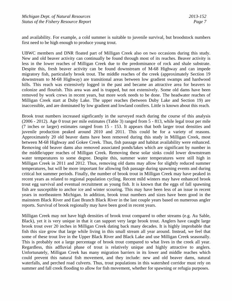
Environment Milligan Creek is one of the larger tributaries to the upper Black River in northeast Michigan (Figure 1). The Black River watershed is a popular trout fishing destination for many anglers, particularly in its upper reaches. Milligan Creek enters the Black River below Kleber Dam (a dam on the Black River) in its lower reaches. Milligan Creek is the only cold water stream downstream of Kleber Dam that provides good intermittent spawning and refuge habitat for brook trout. Black Lake supports a small population of brook trout which use various tributaries for spawning in the fall. Many of these tributaries (Black and Rainy rivers, Mud and Stony creeks) are too warm for trout during the summer months and some are even intermittent which highlights the importance of protecting and enhancing Milligan Creek. Milligan Creek is a designated Michigan trout stream and is managed with Type 1 trout regulations (bag limit of 5 brook trout, minimum size 7 inches) by the Michigan Department of Natural Resources (DNR). It was once known by locals and DNR officials as a high quality brook trout stream, with very large brook trout (20 inches and larger) periodically caught. These larger fish were presumed to have spent some time in Black Lake. However, anglers also mention that smaller brook trout could always be caught in Milligan Creek all year long. The stream was also known for illegal harvest of brook trout decades ago according to local reports. Other species such as walleye and lake sturgeon have been observed spawning in this creek during extremely high water conditions. By the end of the twentieth century, anglers began reporting reduced brook trout catches and an increase in the warm water fish community dominated by creek chubs and white suckers. Milligan Creek begins as an outflow from Duby Lake in the Pigeon River Country State Forest and flows north through aspen, oak, and conifer swamps surrounded by low ridges, crosses under the M-68 Highway, and continues northeast to the Black River (Figure 2). The headwaters are dominated by sand substrate, with high quality gravel and cobble increasing as M-68 Highway is approached. The lower reaches (by Brady/Waveland Road) are dominated by bedrock, boulders, and cobble and have two small natural waterfalls. A variety of cool water streams flow into Milligan Creek including Adair, Weed, Gokee, Spring, and Stony creeks. Gokee Creek is the largest tributary and can support brook trout all year long. Stony Creek is also a sizable tributary but is very warm during the summer months. Beaver dams have been fairly common along the length of Milligan Creek in recent decades. This is especially true for sections 13, 12, and 7 (T34N, R1W/E). Local trappers have historically removed small numbers of beavers from this remote stream corridor. A four-hour trapping-float in 2005 of a reach of Milligan Creek found many beaver dams, but in particular, six very large dams in previously mentioned sections. The Upper Black River Council (UBRC) members have removed some of the older dams, and will continue to do so in the future where they are accessible. While the dams cause much of the potentially good spawning areas to be covered with silt, some high quality spawning

Michigan Dept. of Natural Resources 2013-152 Status of the Fishery Resource Report Page 2 grounds exist between these dams. Old dams are removed in a careful, downstream to upstream manner. This initiative began in 2006. Three small brush/mud dams were removed along with one larger dam directly upstream of the Alexander Hole (deep, popular bend known by locals) in 2006 with the use of explosives. These were the first obstructions directly upstream of M-68 Highway. The explosives were paid for by Trout Unlimited. One local has continued to monitor (and sometimes remove) beaver dams in Milligan Creek, particularly downstream of the confluence of Gokee Creek. It was recommended that an aggressive beaver trapping program was needed beginning in the winter of 2006/07. Attempts were made to remove beavers in the winter of 2007-2008, but trapping effort was minimal. A nuisance trapping permit was obtained by a local trapper for late April of 2008 but the number of beaver taken under this permit was not considered to be significant. An overall trapping program has continued where the reaches of stream are accessible, but many old dams upstream of Gokee Creek will remain. According to models and casual observations, groundwater potential is greater near M-68 Highway and further downstream. Thus, the stream typically runs warmer in the upper reaches, and gains groundwater as it flows toward the highway and its confluence with the Black River. However, excessive ponding from upstream beaver dams was probably increasing water temperatures enough to inhibit the brook trout community, especially in warmer summers. The groundwater influx downstream is often not enough to effectively buffer increased upstream temperatures. DNR Fisheries Division and the Upper Black River Council began collecting summer temperature information for various reaches of this stream in the last decade (Table 1). Mean monthly summer temperatures are high for Milligan Creek at various locations and are often out of the suitable range for brook trout. Trout research in Michigan has demonstrated that monthly average stream temperatures above 66ºF often correlate with a declining or absent brook trout population. Summer monthly average temperatures can often be above this temperature for Milligan Creek, and maximum water temperature can peak above 80ºF (Table 1). The author believes that excessive upstream ponding of this creek is a significant contributor to stream warming.
History Little fisheries data existed for this stream prior to 2006. Stocking records date back to 1938 for Milligan Creek. Brook trout were stocked in Milligan Creek from 1938-1943. In 1966, a large brook trout die-off was noted when an estimated 400 fish died in a one-mile reach. It was believed that warm water triggered a bacterial infection. This is the extent of historical fisheries survey data for Milligan Creek. An action list and schedule was created in 2006 and lists the following management strategies for Milligan Creek for a period of twenty years: 1. Use discretionary surveys at various locations or a fixed sampling site to determine present fish communities and spatial dynamics. It was hypothesized that higher juvenile brook trout catches would be realized in summers when average summer temperatures were cooler. 2. Continue to monitor summer stream temperatures at various locations, or at the same location in multiple years.
Michigan Dept. of Natural Resources 2013-152 Status of the Fishery Resource Report Page 3 3. Continue to work with DNR Forest Resources Division in the Milligan Creek watershed to prevent forestry practices which would enhance beaver populations. 4. Work with local trappers to effectively control beaver populations at key locations in the creek through an aggressive trapping program. Remove dams on state land which warm the downstream reaches considerably and prevent fish passage of resident and Black Lake brook trout. Encourage local riparians and UBRC work crews to remove old dams when noted and to locate dams in the lower reaches of the creek and encourage landowners to allow access to trappers. Many of the above items have been accomplished to varying degrees in recent years and will continue into the future. For Action 1, DNR surveyed a 4,304 ft reach of Milligan Creek each year from 2006 through 2012. For Action 2, DNR and UBRC has monitored water temperature within this survey reach each year since 2006 (Table 1). For Action 3, Fisheries Division has continued to request minimal 300 foot buffers to cutting along the stream. This has been done in assistance with DNR Forest Resources Division. For Action 4, old beaver dams are monitored and removed where possible, and beaver trapping (mostly in-season) is highly encouraged and often monitored.
Current Status Fish Surveys by Year Brook trout surveys were completed by DNR at Milligan Creek annually from 2006 through 2012. Four experimental stations were surveyed in 2006 (Table 2). All stations were in the middle/lower reaches of Milligan Creek. Stations 1 and 2 were close in proximity and separated by a short reach of creek. Stations 1 and 2 represented a wide range of habitat encompassing shallow water, deep pools, and both grassy and forested corridors. Thus, stations 1 through 4 were surveyed in 2006, while only stations 1 and 2 were surveyed from 2007 through 2012. Stations: 1) Ross Nave cabin -beginning at the landowner cabin and proceeding upstream to the Alexander Hole (2,841 feet). This is just upstream of M-68 Highway. 2) M-68 Highway -beginning downstream of the Bandish Cabin walkbridge about 300 feet and proceeding upstream to 100 feet above the highway (1,463 feet). 3) Kisser Road -beginning upstream of the road at the house stairs and proceeding upstream to a present beaver dam. 4) Waveland Road -beginning below the lower falls and proceeding upstream to the upper falls plunge pool. 2006 The first assessment of the current brook trout population in Milligan Creek was made in August 2006. Backpack electrofishing unit(s) were used for approximately 6,040 feet of stream at all four sampling stations. These were one-pass electrofishing stations and were done at all four stations in order to gain a better understanding of the fish community (particularly brook trout) and to establish a future subset sampling station.

Michigan Dept. of Natural Resources 2013-152 Status of the Fishery Resource Report Page 4 Trout densities were very low or even absent at all four 2006 sampling stations (Table 3). No stable fishery could be provided from such low numbers. Densities for all four locations combined were found to be less than 16 brook trout per mile of stream. Juvenile brook trout were virtually absent from the survey. It was believed that age 1 and older trout seek thermal refuge in specific locations in this stream during the warmer summer months. Due to limited thermal refugia, mortality was believed to be extremely high, especially for juveniles. Young trout were virtually absent at all four sampling locations, despite an ample amount of spawning substrate. Young-of-year (age 0) brook trout may have colder water requirements for development and growth. They also may have limited ability to migrate to thermal refuge during critical summer periods, and even if they could, must compete for space with other trout in colder reaches of the creek. Thus, mortality of these young trout may be near 100% in given years. This could limit eventual broodstock populations. Fair numbers of age 2 brook trout were surveyed when compared to age 1 fish in 2006. The summer of 2004 was cool (Table 1), thus more young trout (age 0) may have survived to later ages as a result of the cold summer temperatures that year. Overall growth of brook trout from this sample was good (Table 4), a theme which would continue annually through the 2012 survey. The growth index was +1.3 inches, meaning that fish of a certain age grew more than an inch faster than the statewide average for this species. This is to be expected as a result of the warmer water which stimulates food production, as well as the limited competition among trout. Other species observed in the sampling reaches included: blacknose dace, creek chub, central mudminnow, blackside darter, Johnny darter, burbot, white sucker, sculpin species, and common shiner. Most of these species remained abundant at future survey sites on Milligan Creek. Also present at Site 4 (falls downstream) were yellow perch, rock bass, bullhead species, and smallmouth bass. The creek chub population is dominant, with many large individuals present. It was speculated that the brook trout are highly vulnerable to this burgeoning creek chub population as a result of: competition for space and forage, and predation of chubs on young trout. 2007 Two of the survey sites previously listed (Stations 1 and 2) were again surveyed on September 10, 2007. These two stations combined were 4,304 feet and were considered representative of the lower/middle reaches of Milligan Creek. The only difference between the years was that two backpack electrofishing units were used at Site 1 in 2007 (compared to 1 unit the previous year). Catches of all size brook trout increased at the pooled sites in 2007 and growth of trout remained excellent. Many more juvenile trout (age 0) were caught compared to 2006 and could have been correlated with slightly cooler (average) temperatures in 2007. 2008 The year 2008 was relatively cooler with colder summer temperatures for Milligan Creek (Table 1). The maximum temperatures were also less lethal as compared to previous years. Pooled stations 1 and 2 were again surveyed with two backpack shockers on September 10, 2008. Catches of brook trout were much higher than in previous years, especially for age 0 fish. Growth rates were still above statewide average (+0.6") but slightly below the previous years which could be explained by increased numbers (competition). The higher numbers of young trout were encouraging. Less than five beaver dams were again removed in Milligan Creek at the end of summer and trapping efforts (though
Michigan Dept. of Natural Resources 2013-152 Status of the Fishery Resource Report Page 5 minimal) continued. Thus far (based on 3 years), a higher catch of age 0 brook trout in the late-summer was achieved as average temperatures in July and August were lower. 2009 Stations 1 and 2 were again surveyed on September 1, 2009. The summer of 2009 was characterized as very cool with ample precipitation. In fact, the Milligan Creek watershed received near record rains prior to this survey, enough rain to allow unhindered fish passage through Brady Falls which may have enabled greater movement of larger brook trout from downstream, or even Black Lake. This upstream summer and fall trout movement is often blocked by not only the falls, but also by large perched culverts at Waveland Road. Due to the high water conditions, we changed gear from two backpack shocking units, to a stream shocker with two probes. It is reasonable to stipulate that this gear is more efficient than backpack shockers, however, the fast and high water probably balanced catches out, making years comparable. Catches of brook trout in 2009 were again higher than in previous warmer years, especially for age 0 fish (Table 3). The continued higher numbers of young trout were encouraging, but it could not be determined if it was a result of the colder summer weather (probable) or beaver dam removal efforts. A handful of beaver dams were again removed in Milligan Creek at the end of summer and trapping efforts (though minimal) continued. Hourly temperature was also collected at the Bandish Cabin (near M-68 Highway) as in previous years (Table 1). Milligan Creek ran considerably colder in 2009 as evident by average temperatures by month. It was becoming evident after four years that a higher catch of age 0 brook trout in the late-summer could be achieved when average temperatures in July and August were lower. 2010 Stations 1 and 2 were surveyed on September 13, 2010. The summer of 2010 was characterized as warm with fair amounts of precipitation. Once again, the water level was normal enough to use two backpack shockers for surveying trout. Catches of brook trout were again fairly high despite the warm summer weather. The catches of age 1 and 2 trout were high most likely due to the increase in age 0 brook trout in the previous two years, with sufficient survival to age 1 for both year classes. It is the author's belief that the production of brook trout in Milligan Creek was very high in 2010, but that summer temperatures did have an impact on survival of a proportion of juvenile brook trout. The highest number of legal trout per mile was attained during the 2010 survey compared to other surveys (Table 3). Growth of fish, as in previous years, remained good. Seven old beaver dams were removed in Milligan Creek in 2010 upstream of the survey reach. Hourly temperatures were also gathered at the Bandish Cabin site as in previous years (Table 1). Though the summer was warm, average July and August temperatures were still within a range of acceptability for a brook trout population. 2011 Stations 1 and 2 were surveyed on September 12, 2011. The summer of 2011 was characterized as very warm and rainy at times. Stream temperatures were very high that year (Table 1) with both high July and August averages and maximum temperatures. Water level during the survey was suitable to use two backpack shockers. The difference was that the upstream end (a particular deep hole) of the survey site was partially surveyable whereas in most years it was too deep to survey. We caught good
Michigan Dept. of Natural Resources 2013-152 Status of the Fishery Resource Report Page 6 numbers of large brook trout in this hole in 2011 and probably missed many more. Growth was comparable to other years. Large numbers of age 2 brook trout were collected ranging from 8-13 inches. The highest number of age 0 trout per mile (813) was collected this year (Table 3). A large (16 inch) brook trout was collected but not aged. The number of age 0 trout collected in 2011, despite the warm weather, were high again which was similar to 2010. Juvenile trout production in 2011 was very good since adult brood numbers were higher from the year before, but may have been even greater than observed. Varying forces of natural mortality for juveniles (warm temperatures and competition/predation from concentrated adults) probably culled large numbers of juveniles prior to this survey. Growth was average for age 0 and age 1 brook trout. Growth was excellent (when compared to other Michigan stream brook trout) for age 2 and older fish. No upstream beaver dams were removed from the creek this summer, although large numbers are known to exist. 2012 Stations 1 and 2 were surveyed on September 10, 2012 using two backpack shocking units in the final year of this examination. The summer of 2012 was very hot, with many record high temperatures established throughout Michigan. Locally, northern Michigan again experienced a mild winter (2011/2012) with lower snowfall levels. Stream levels were also considerably lower regionally. Fishing for brook trout was excellent in nearby streams (such as the Black River) in 2012, despite warmer ambient temperatures. Reports were fair in number of anglers catching "holed up" trout in Milligan Creek this summer as well. During the 2012 survey, the deep hole at the end of station 1 was again surveyed. As predicted, the catch of age 0 trout in this reach was significantly lower than from 2008 through 2011 (Table 3) It is also evident that fewer adults could be found in this reach. With warmer water temperatures, it was predictable that juvenile catches would be down. Average July water temperature was the highest recorded since 2006 (71F). This theoretically is well out of the brook trout's surviving range. Despite this, trout still survive here, but they have adapted to movement in the system and finding localized coolwater refugia. This may be less true for juveniles who do not possess the swim strength or knowledge of where these locations exist. Many of the age 1 trout observed in this survey were extremely skinny and unhealthy looking, and many had black parasites attached. We had seen this to a lesser extent in some previous surveys, especially in warm years. Young fish (age 0) and older fish (age 2+) appear to do well in this stream.
Analysis and Discussion Local anglers voiced concerns over poor brook trout catches in Milligan Creek in recent decades. There was also concern over stream and riparian corridor damage caused by unchecked beaver populations. We spent seven years examining various reaches of this creek with different tools. We measured hourly summer temperature at various Milligan Creek sites, and in particular, at one site near M-68 Highway. We also surveyed a 4,304 foot reach of the creek each year with one-pass electrofishing and were able to compare annual catches in unison with summer temperatures. Summer water temperatures influence brook trout abundance and survival. We hypothesized that juvenile brook trout (age 0) catches would be inversely proportional to summer stream temperature. Our catches of brook trout did increase during colder summers, but no direct relationship was particularly evident (Figure 3). There were other variables to consider such as broodstock levels and habitat accessibility
Michigan Dept. of Natural Resources 2013-152 Status of the Fishery Resource Report Page 7 and availability. For example, a cold summer is suitable to juvenile survival, but broodstock numbers first need to be high enough to produce young trout. UBWC members and DNR floated part of Milligan Creek also on two occasions during this study. New and old beaver activity can continually be found through most of its reaches. Beaver activity is less in the lower reaches of Milligan Creek due to the predominance of rock and shale substrate. Despite this, fresh beaver activity can be found downstream of M-68 Highway and can impede migratory fish, particularly brook trout. The middle reaches of the creek (approximately Section 19 downstream to M-68 Highway) are transitional areas between low gradient swamps and hardwood hills. This reach was extensively logged in the past and became an attractive area for beavers to colonize and flourish. This area was and is trapped, but not extensively. Some old dams have been removed by work crews in recent years, but more work needs to be done. The headwater reaches of Milligan Creek start at Duby Lake. The upper reaches (between Duby Lake and Section 19) are inaccessible, and are dominated by low gradient and lowland conifers. Little is known about this reach. Brook trout numbers increased signficantly in the surveyed reach during the course of this analysis (2006 - 2012). Age 0 trout per mile estimates (Table 3) ranged from 5 - 813, while legal trout per mile (7 inches or larger) estimates ranged from 15 - 153. It appears that both larger trout densities and juvenile production peaked around 2010 and 2011. This could be for a variety of reasons. Approximately 20 old beaver dams have been removed during this study in Milligan Creek, most between M-68 Highway and Gokee Creek. Thus, fish passage and habitat availability were enhanced. Removing old beaver dams also removed associated ponds/lakes which are significant by number in the middle/upper reaches of Milligan Creek. Removing these solar sinks could lower downstream water temperatures to some degree. Despite this, summer water temperatures were still high in Milligan Creek in 2011 and 2012. Thus, removing old dams may allow for slightly reduced summer temperatures, but will be more important for allowing fish passage during spawning events and during critical hot summer periods. Finally, the number of brook trout in Milligan Creek may have peaked in recent years as related to regional population cycling. Recent mild winters may have enhanced brook trout egg survival and eventual recruitment as young fish. It is known that the eggs of fall spawning fish are susceptible to anchor ice and winter scouring. This may have been less of an issue in recent years in northeastern Michigan. In addition, brook trout numbers and sizes have been good in the mainstem Black River and East Branch Black River in the last couple years based on numerous angler reports. Survival of brook regionally may have been good in recent years. Milligan Creek may not have high densities of brook trout compared to other streams (e.g. Au Sable, Black), yet it is very unique in that it can support very large brook trout. Anglers have caught large brook trout over 20 inches in Milligan Creek dating back many decades. It is highly improbable that fish this size grow that large while living in this small stream all year around. Instead, we feel that some of these trout live in the Upper Black River and Black Lake and use Milligan Creek seasonally. This is probably not a large percentage of brook trout compared to what lives in the creek all year. Regardless, this adfluvial phase of trout is relatively unique and highly attractive to anglers. Unfortunately, Milligan Creek has many migration barriers in its lower and middle reaches which could prevent this natural fish movement, and they include: new and old beaver dams, natural waterfalls, and perched road culverts. Thus, trout populations in this watershed corridor must rely on summer and fall creek flooding to allow for fish movement, whether for spawning or refugia purposes.

Michigan Dept. of Natural Resources 2013-152 Status of the Fishery Resource Report Page 8
Management Direction The purpose of this seven year study was to learn more about factors influencing the brook trout population of Milligan Creek. This included gathering and synthesizing biological data such as annual water temperatures and fisheries community data. In addition, we also gathered historical and recent angler accounts for this creek and watershed. We feel that Milligan Creek has and will always be a stream that is marginal for brook trout based on variable annual water temperature. Despite this, it has the potential for large trout and is able to provide a localized fishery. Knowing this, it is important to protect this stream in its current status and to prevent further erosion of water temperatures and riparian/in-stream habitat. It will be up to resource agencies and interested individuals to maintain the quality of Milligan Creek, and most importantly, to enhance it where possible. The creek has a Type 1 trout stream regulation status which remains appropriate. The following are management actions that should be carried out at Milligan Creek into the next twenty years by resource agencies, watershed councils, and even individuals. They are discussed in relative order of importance and need. 1. Remove the perched double culverts and Waveland Road and replace with a timber bridge or appropriately sized structure. These culverts are impassible except during flood stage and hinder movement of all species upstream to important spawning areas. Inspect the culverts at Brady Road for the same purpose. 2. Maintain directed trapping efforts in the entire creek, but especially from Section 19 downstream to its confluence with the Upper Black River. This effort needs to be organized by the Upper Black River Council and results of the trapping efforts need to be documented for future managers. 3. Inventory and remove beaver dams through a slow draw-down process from Section 19 downstream to the confluence with the Upper Black River. These efforts should also be coordinated among the Upper Black River Council, the DNR Fisheries Division and Forest Resources divisions. Proper Forest Treatment Proposals should be established by DNR for such efforts. 4. Continue to maintain a quality summer water temperature dataset for one location on Milligan Creek. This effort is coordinated between the Upper Black River Council and DNR Fisheries Division. This should be continued since stream temperature is believed to play a large role in shaping this trout population and those in the Black River watershed. 5. Encourage anglers to annually provide brook trout catch data for Milligan Creek to DNR Fisheries Division personnel. Such information is useful to managers in the absence of DNR survey data. 6. Re-survey the 4,304 foot reach of Milligan Creek approximately every five years to continue this dataset. 7. DNR Fisheries Division will continue to work with DNR Forest Resources Division to maintain healthy riparian corridors along Milligan Creek and ensure timber management activities do not promote beaver activity.

Michigan Dept. of Natural Resources 2013-152 Status of the Fishery Resource Report Page 9
References

Figure 1. Location of Milligan Creek in northern Michigan.
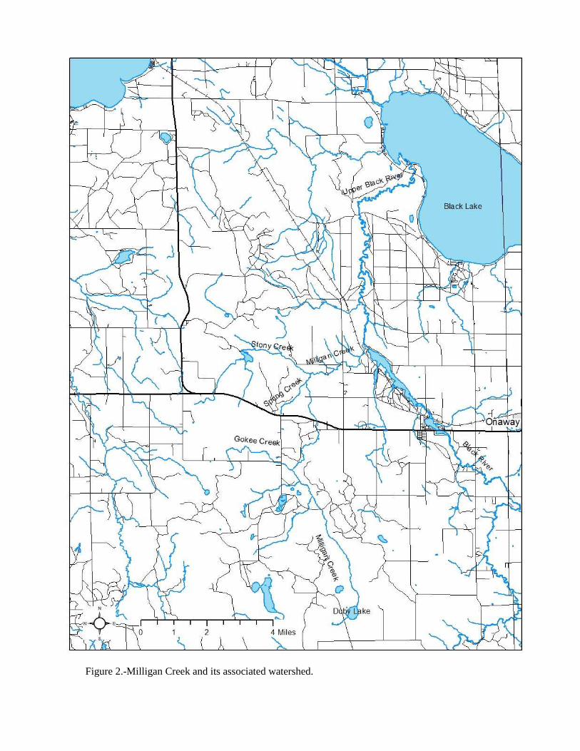
Figure 2.-Milligan Creek and its associated watershed.
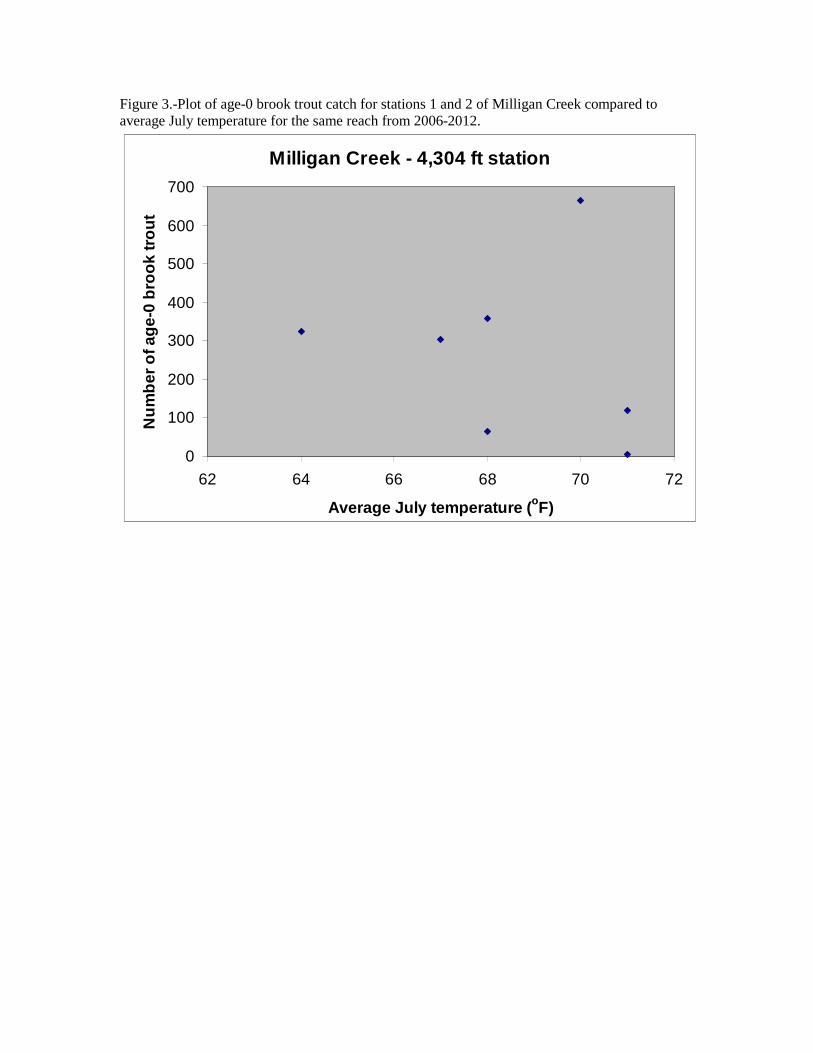
Figure 3.-Plot of age-0 brook trout catch for stations 1 and 2 of Milligan Creek compared to average July temperature for the same reach from 2006-2012.
Milligan Creek - 4,304 ft station
0
100
200
300
400
500
600
700
62 64 66 68 70 72
Average July temperature (oF)
Nu
mb
er o
f ag
e-0
bro
ok
tro
ut
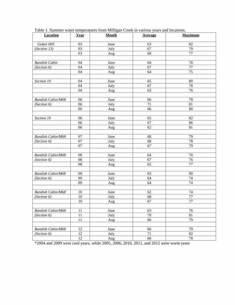
Table 1. Summer water temperatures from Milligan Creek in various years and locations. Location Year Month Average Maximum
Gokee Hill 03 June 63 82 (Section 13) 03 July 67 79 03 Aug 68 77 Bandish Cabin 04 June 64 78 (Section 6) 04 July 67 77 04 Aug 64 75 Section 19 04 June 65 80 04 July 67 78 04 Aug 63 76 Bandish Cabin/M68 06 June 66 78 (Section 6) 06 July 71 81 06 Aug 66 80 Section 19 06 June 65 82
06 July 67 86 06 Aug 62 81
Bandish Cabin/M68 07 June 68 79 (Section 6) 07 July 68 78
07 Aug 67 79
Bandish Cabin/M68 08 June 64 76 (Section 6) 08 July 67 76
08 Aug 65 77
Bandish Cabin/M68 09 June 63 80 (Section 6) 09 July 64 74
09 Aug 64 74
Bandish Cabin/M68 10 June 62 74 (Section 6) 10 July 68 77
10 Aug 67 77
Bandish Cabin/M68 11 June 63 76 (Section 6) 11 July 70 81
11 Aug 66 79
Bandish Cabin/M68 12 June 66 79 (Section 6) 12 July 71 82
12 Aug 66 78 *2004 and 2009 were cool years, while 2005, 2006, 2010, 2011, and 2012 were warm years

Table 2. Station description and catch data for Milligan Creek 2006. All four stations were surveyed in 2006, but only stations 1 and 2 were surveyed in other years. Station T, R,
S Backpack Shockers
Used
Station length
(ft)
Date Water Temp
(F)
Substrate No. Species
No. Brook Trout
Brook trout per mile
1 34N, 1E, 6/7
1 2,841 Aug 29
- Sand, gravel, cobble
7 5 10.6
2 34N, 1E, 6
2 1,463 Aug 10
- Gravel, cobble
7 16 58.1
3 34N, 1W,
1
2 740 Aug 29
61 Sand, gravel, cobble
7 1 5.3
4 35N, 1E,
29/32
1 1,000 Aug 29
65 bedrock 11 0 0.0
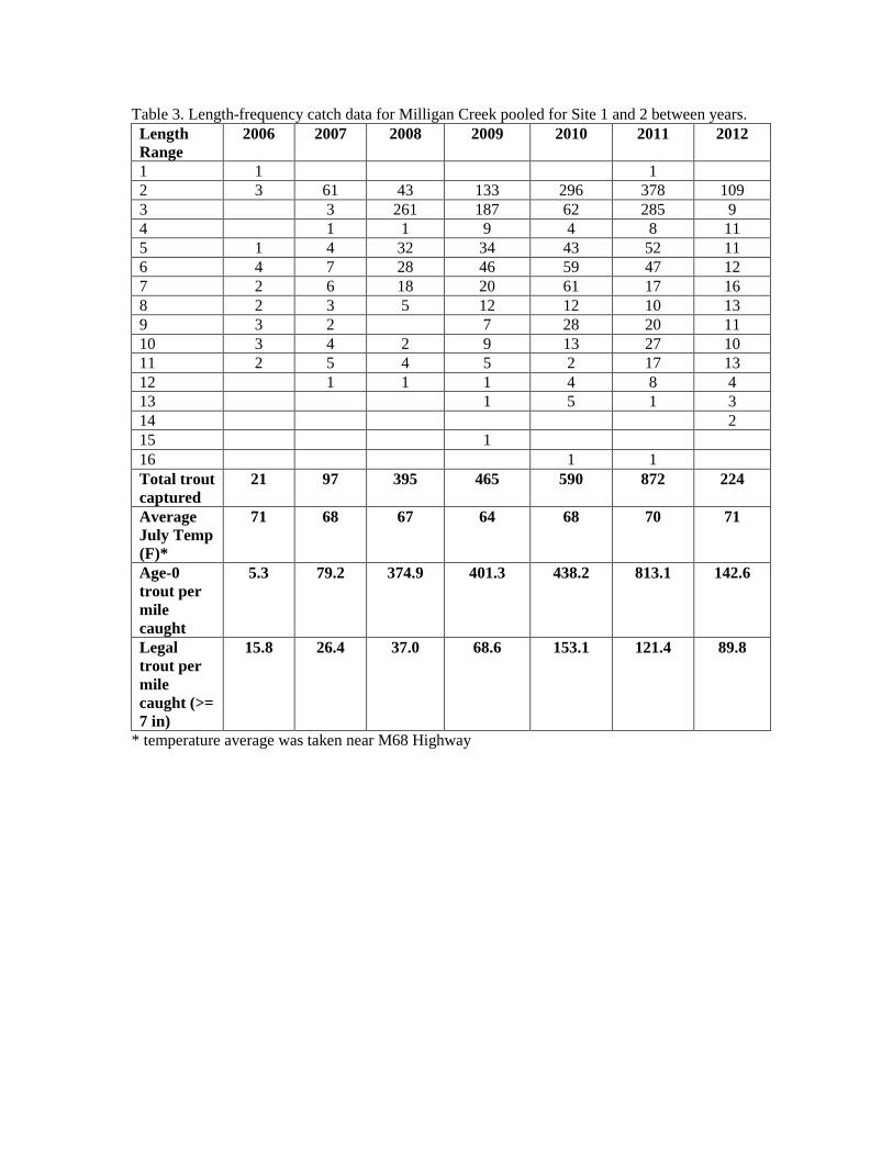
Table 3. Length-frequency catch data for Milligan Creek pooled for Site 1 and 2 between years. Length Range
2006 2007 2008 2009 2010 2011 2012
1 1 1 2 3 61 43 133 296 378 109 3 3 261 187 62 285 9 4 1 1 9 4 8 11 5 1 4 32 34 43 52 11 6 4 7 28 46 59 47 12 7 2 6 18 20 61 17 16 8 2 3 5 12 12 10 13 9 3 2 7 28 20 11 10 3 4 2 9 13 27 10 11 2 5 4 5 2 17 13 12 1 1 1 4 8 4 13 1 5 1 3 14 2 15 1 16 1 1 Total trout captured
21 97 395 465 590 872 224
Average July Temp (F)*
71 68 67 64 68 70 71
Age-0 trout per mile caught
5.3 79.2 374.9 401.3 438.2 813.1 142.6
Legal trout per mile caught (>= 7 in)
15.8 26.4 37.0 68.6 153.1 121.4 89.8
* temperature average was taken near M68 Highway
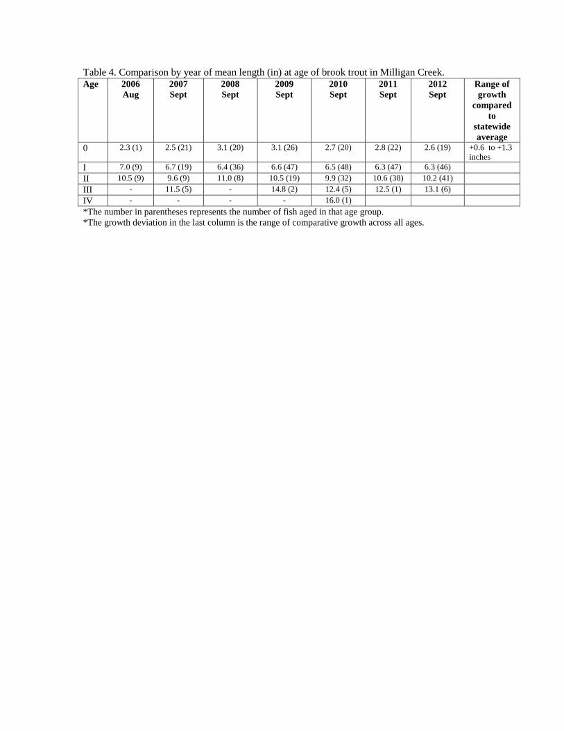
Table 4. Comparison by year of mean length (in) at age of brook trout in Milligan Creek. Age 2006
Aug 2007 Sept
2008 Sept
2009 Sept
2010 Sept
2011 Sept
2012 Sept
Range of growth
compared to
statewide average
0 2.3 (1) 2.5 (21) 3.1 (20) 3.1 (26) 2.7 (20) 2.8 (22) 2.6 (19) +0.6 to +1.3 inches
I 7.0 (9) 6.7 (19) 6.4 (36) 6.6 (47) 6.5 (48) 6.3 (47) 6.3 (46)
II 10.5 (9) 9.6 (9) 11.0 (8) 10.5 (19) 9.9 (32) 10.6 (38) 10.2 (41)
III - 11.5 (5) - 14.8 (2) 12.4 (5) 12.5 (1) 13.1 (6)
IV - - - - 16.0 (1)
*The number in parentheses represents the number of fish aged in that age group. *The growth deviation in the last column is the range of comparative growth across all ages.