lake templene status of the fishery resource report, 2014 … · michigan dept. of natural...
TRANSCRIPT
Michigan Dept. of Natural Resources 2014-182 Status of the Fishery Resource Report Page 1
Lake Templene St. Joseph County, T6S, R10W, S26-27, 32-34 and T7S, R10W, S3-5
St. Joseph River Watershed, 2013
Brian Gunderman - Senior Fishery Management Biologist
Environment
Lake Templene is an impoundment on the Prairie River located 2 miles southeast of the village of Centreville (Figure 1). The Lake Templene Dam was constructed in 1970, inundating existing wetlands and three natural lakes to create an impoundment with a surface area of approximately 870 acres. The lake has a maximum depth of 35 ft and a mean depth of 4.9 ft (Progressive AE 2000). Due to its irregular shape, the lake has a high shoreline length to surface area ratio. The legal summer maximum lake level for Lake Templene is 828.5 ft above sea level. At this elevation the perimeter of the lake is 18.8 miles. As an impoundment, Lake Templene has a relatively short hydraulic residence time. On average the entire volume of water in the lake is replaced by incoming water in only 26 days (Progressive AE 2000). This means that water quality in the lake is heavily influenced by the quality of the incoming water from the Prairie River. Water also enters Lake Templene from neighboring lakes through two small intermittent drains. Sand Lake is connected to Lake Templene via an underground pipe (Figure 2). A one-way valve in the pipe is designed to open when the water level in Sand Lake exceeds the water level in Lake Templene, thus allowing water to exit Sand Lake. Another human-made connection allows water to flow from Fish Lake into Lake Templene when the water surface elevation on Fish Lake exceeds the legal lake level. The Lake Templene watershed (i.e., the land area that drains into the lake) covers 118 square miles (Progressive AE 2000). Surficial materials in this area primarily consist of glacial outwash sand and gravel overlaid by loamy sands. These materials are porous and allow rapid infiltration of precipitation. Darcy maps indicate moderate potential for groundwater inputs along the southern edge of Lake Templene, and low potential for groundwater inflow along the north shore where the topography is relatively flat. Land cover data from the Michigan Department of Natural Resources (MDNR) Aquatic Habitat Viewer indicates that agriculture (67%) is the most common land use in the watershed, followed by wetlands (13%) and forests (11%). Most of the land immediately adjacent to Lake Templene has been modified for residential or vacation home development. The 2013 habitat survey revealed a dwelling density of 18.1 dwellings/mile, which is near the 25% percentile for lakes in southwest Michigan (K. Wehrly, MDNR - Fisheries Division, unpublished). Approximately 42% of the shoreline is armored with seawalls or riprap. Large woody cover is abundant upstream of Findley Road and along the undeveloped shoreline near Glen Oaks Community College. Throughout the remainder of the shoreline, large woody cover is scarce. A township boat launch on the west side of Nottawa Road provides public access to Lake Templene (Figure 2). Limnological sampling was conducted at the deepest point in Lake Templene on August 21, 2013. As expected, the lake was thermally stratified (Figure 3). The epilimnion extended from the surface to a

Michigan Dept. of Natural Resources 2014-182 Status of the Fishery Resource Report Page 2 depth of 6 ft. Water temperatures within the epilimnion were relatively uniform, ranging from 77.1 F to 77.4 F. The metalimnion (zone of thermal change) extended from 6 ft to 26 ft. Water temperatures declined from 77.1 F at the top to 49.3 F at the bottom of the metalimnion. The cold waters of the hypolimnion extended from 26 ft to the bottom of the lake. The dissolved oxygen distribution within Lake Templene followed a clinograde curve, with the highest oxygen concentrations occurring near the surface (Figure 3). The Michigan water quality standard for protecting warmwater fish and other aquatic life is 5 ppm (Public Act 451 of 1994). Dissolved oxygen concentrations in Lake Templene exceeded this standard to a depth of 14 ft. Total alkalinity was 186 mg/L, which is indicative of a hardwater lake with substantial buffering capacity (Shaw et al. 2004). The biological productivity of a lake is strongly dependent on its supply of two key nutrients: phosphorus and nitrogen. Nitrogen is the limiting nutrient when the ratio of total nitrogen to total phosphorus is <10:1, and phosphorus is the limiting nutrient when this ratio is >15:1 (Shaw et al. 2004). In Lake Templene, the ratio of total nitrogen to total phosphorus was 67:1. Thus, phosphorus is the limiting nutrient in this system. The total phosphorus concentration was 0.0102 mg/L. The chlorophyll a concentration, which provides an index of algal biomass, was 0.0031 mg/L. The Secchi disk depth (a measure of water transparency) was 11 ft. Based on these water quality parameters, Lake Templene is considered a mesotrophic or moderately productive lake (Carlson and Simpson 1996).
History
Water quality data for Lake Templene were collected during 1983-1984, 1999, and 2009-2011. The data from 1999 were collected by Progressive AE (2000), and the remainder of the data was collected by the Lake Templene Property Owners Association in conjunction with the Michigan Department of Environmental Quality's (MDEQ) Cooperative Lakes Monitoring Program. Water transparency (i.e., the Secchi disk depth) has varied from median values of 7.3 ft in 1983-1984 to 5.5 ft in 1999 and 11.5 ft in 2009-2011. Chlorophyll a concentrations have fluctuated between and within sampling years. Median chlorophyll a concentrations were 0.0025 mg/L in 1999 and 0.0013 mg/L in 2009-2011. Median total phosphorus concentrations near the surface declined from 0.021 mg/L in 1999 to 0.016 mg/L in 2009-2011. The median total phosphorus concentration at mid-depth (which is more comparable to the nutrient data collected by MDNR in 2013) was 0.025 mg/L in 1999 (Progressive AE 2000). In general, limnological sampling suggests that nutrient concentrations have been decreasing and water transparency has been increasing since 1999. Numerous factors affect water quality in this system including use of best management practices on riparian properties upstream and adjacent to Lake Templene, precipitation patterns, and uptake of nutrients by aquatic plants. Several winter drawdowns have been implemented on Lake Templene. The most recent drawdowns occurred during the winters of 2008-09, 2010-11, 2011-12, and 2013-14. Water surface elevations were reduced by 4 ft. Drawdowns commenced around October 1st and proceeded at a rate of approximately 3 inches per day. Refilling typically began around March 10 and was completed by March 31. The drawdowns were implemented to facilitate dam repairs and to control nearshore growth of aquatic vegetation. Approximately 1,000 fall fingerling walleyes were stocked in the lake each year during 2003-2005. These fish were purchased from a private hatchery by local anglers and stocked under permit from MDNR. The lake also has been a popular destination for bass anglers. For many years, anglers used a makeshift landing off Nottawa Road to access the lake. Disputes arose between riparian property

Michigan Dept. of Natural Resources 2014-182 Status of the Fishery Resource Report Page 3 owners and tournament anglers. In an effort to alleviate this tension and reduce safety concerns on Nottawa Road, Nottawa Township passed an ordinance in 2010. This ordinance restricted the number of fishing tournaments on Lake Templene to 25 per year and mandated the development of a public boat launch and parking area on Township property on the west side of Nottawa Road.
Current Status
The first fish community survey on Lake Templene was conducted by MDNR during April 29-May 2, 2013. Fish were captured using trap nets, fyke nets, gill nets, seines, and nighttime electrofishing gear (Table 1). Total lengths were recorded for all fish. For game fish species, spine or scale samples for age determination were collected from 10 fish per inch group. Weights for all species were calculated using the length-weight regression coefficients compiled by Schneider et al. (2000b). Twenty-eight fish species (plus hybrid sunfishes) were collected during the 2013 survey (Table 2). Bluegill (n = 3,504) was the most abundant species, composing 62% of the catch by number and 36% of the catch by weight. Forty-eight percent of the bluegills were 6 inches or larger. Size structures of bluegill populations can be challenging to interpret because each gear type exhibits some degree of size selectivity (Figure 4). In an effort to minimize the subjectivity associated with analyses of bluegill catch data, Schneider (1990) developed a standardized scoring system for interpreting length-frequency distributions of bluegills collected with various types of sampling gear. The size scores for the Lake Templene bluegill population were 5.6 (good-excellent) based on the trap net and large-mesh fyke net samples and 2.4 (poor-acceptable) based on the electrofishing sample. The mean growth index for bluegills was +1.0, which is indicative of above average growth (Figure 5). Eight year classes of bluegills were collected (Figure 6). Two year classes (ages 1 and 2) made up 72% of the bluegill catch. Total annual mortality for adult bluegills ages 3-7 was estimated to be 62% (Figure 7). Black crappies (n = 422) composed 19% of the total fish biomass in the catch. Ninety-eight percent of the black crappies were 7 inches or larger (Figure 8) and the average length was 10.0 inches. Three year classes (ages 2-4) made up 82% of the black crappie catch (Figure 9). Amongst the older year classes, the 2003 year class (age 10) was particularly strong. The mean growth index for black crappies was +1.4, which is indicative of above average growth (Figure 10). Pumpkinseeds (n = 115) and yellow perch (n = 73) composed 3% of the total fish biomass during the survey. Sixty-three percent of the pumpkinseeds were 6 inches or larger and 41% of the yellow perch were 7 inches or larger (Figure 11). Substantial variation in growth patterns was observed between and within cohorts of both species (Figures 12-13). Overall, growth was classified as average based on the mean growth indices of +0.7 for pumpkinseeds and +0.4 for yellow perch. Several year classes were captured for each species (Figure 14). Largemouth bass (n = 99) were the most abundant predators in the catch. Legal-sized fish (14 inches and larger) made up 6% of the sample (Figure 15), and the maximum observed age for largemouth bass was 8 years (Figure 16). Mean lengths at age were similar to statewide averages for fish ages 2-4 but were more than an inch below average for fish ages 6-7 (Figure 17).

Michigan Dept. of Natural Resources 2014-182 Status of the Fishery Resource Report Page 4 Northern pike (n = 5), channel catfish (n = 4), and walleyes (n = 2) made up 3% of the total fish biomass in the catch (Table 2). The available data suggest that growth was above average for northern pike. The 22-inch walleye was from the 2007 year class and the 26-inch walleye was from the 2004 year class.
Analysis and Discussion
Bluegills are the primary game fish in Lake Templene. Catch-per-effort (CPE) with specific gear types provides abundance indices that can be compared to values for lakes sampled throughout Michigan during 2002-2007 as part of the MDNR's Status and Trends Program (STP; K. Wehrly, MDNR - Fisheries Division, unpublished). In Lake Templene the bluegill CPEs for large-mesh fyke nets, trap nets, and electrofishing gear were in the top 5% of the values recorded for STP lakes. The electrofishing CPE was 25.7 bluegills/minute, which is higher than recorded for any STP lakes in southwest Michigan. Thus, it appears that bluegill abundance in Lake Templene is high relative to other lakes in the region and throughout the state. There was a large discrepancy between the bluegill size score based on the fyke net and trap net samples and the size score based on the electrofishing sample. The size score based on the netting effort (5.6 or good-excellent) probably is a more reliable indicator of the quality of the fishery. The nets were fished for three nights, whereas electrofishing was only conducted on a single night. Schneider (1990) noted similar concerns regarding the suitability of one-night electrofishing survey data for calculating size scores. Three factors determine the size structure of bluegill populations: recruitment, annual mortality, and growth. Because sampling only was conducted during a single year, data on year-to-year variation in recruitment in Lake Templene are not available. Based on the catch curve analysis (which assumes consistent recruitment across years), total annual mortality was estimated to be 62%. This estimate falls near the middle of the range reported by Schneider (2000) for Michigan bluegill populations. Bluegills in Lake Templene are growing rapidly. Optimal prey and habitat types change as bluegills increase in size. Juvenile bluegills typically consume macroinvertebrates (such as aquatic insects and snails) in vegetated areas, whereas larger bluegills often forage on Daphnia in open water (Spotte 2007). In Lake Templene above average growth, coupled with average annual mortality, has produced a bluegill population with a good-excellent size structure. Black crappies can provide seasonally important fisheries in Michigan lakes, especially immediately prior to and during the spring spawning period. In Lake Templene, the black crappie CPE with large-mesh fyke nets was higher than any CPE recorded during the 2002-2007 STP surveys (K. Wehrly, MDNR - Fisheries Division, unpublished). Several factors affect spawning and recruitment of black crappies. Guy and Willis (1995) found that black crappie recruitment was most consistent in lakes with high shoreline length:surface area ratios and high watershed area:lake area ratios. Lake Templene fits this description. Preferred crappie spawning habitat consists of embayments with little or no shoreline development, abundant cover (i.e., emergent vegetation or large woody structure), and minimal wave action (Guy and Willis 1995; Pope and Willis 1997; Reed and Pereira 2009). The highest CPE for black crappie in Lake Templene occurred in this type of habitat along the southwest corner of the lake. The timing of the 2013 survey also contributed to the high catch rate as black crappies are most vulnerable to sampling gear during the pre-spawn period and move offshore after spawning.

Michigan Dept. of Natural Resources 2014-182 Status of the Fishery Resource Report Page 5 Yellow perch occupy offshore areas during the period when most fish community surveys are conducted and perch typically compose a small percentage of the total fish biomass in the catch. Yellow perch populations exhibit wide annual variation in natural recruitment (Forney 1971). Thus, the scarcity of age 5 and older yellow perch in the sample could have been caused by sampling bias, high adult mortality (e.g., due to harvest), or poor recruitment of the 2008 and preceding year classes. Predators (largemouth bass, northern pike, channel catfish, walleye, gar, and bowfin) composed 14% of the total fish biomass during the survey. Schneider (2000) observed that predators typically make up 20-50% of the biomass in lakes with desirable fish communities. The 2013 catch data indicate that the predator-prey ratio in Lake Templene is below the desired range. Survey timing and gear selection can affect the species composition of the catch. For example, nearly all of the spotted gar were collected in one gill net, so the relative biomass of spotted gar in the sample probably would have been higher if more gill nets had been deployed. Nighttime electrofishing typically is the most effective method for capturing adult and sub-adult largemouth bass. The largemouth bass CPE for Lake Templene was 2.3 fish/minute, which is in the top 15% of values recorded statewide during the 2002-2007 STP surveys and between the 50th and 75th percentiles for lakes in southwest Michigan (K. Wehrly, MDNR - Fisheries Division, unpublished). Thus, largemouth bass abundance appears to be higher than the statewide average and within the normal range for lakes in southwest Michigan. Length-at-age data for Lake Templene suggest that growth rates are average until age 4 and decline below average for older fish. A possible explanation for the observed pattern is that fishing mortality is higher for fast-growing bass than for slow-growing bass. Fast growing individuals reach legal size earlier and likely have a shorter life span than slow-growing individuals. Northern pike are rare in Lake Templene. Summer habitat appears to be one of the factors limiting pike abundance in this system. Casselman (1978) found that the optimum temperature range for growth of juvenile and adult northern pike was 66-70 F and that pike generally avoided water temperatures > 73.4 F. Although northern pike are capable of tolerating low oxygen concentrations (Casselman 1978), Headrick and Carline (1993) reported that pike were rarely located in depth strata with dissolved oxygen concentrations below 3.0 ppm. During August 2013, the depth strata in Lake Templene with water temperatures 73.4 F or lower and dissolved oxygen concentrations > 3.0 ppm was from 12 ft to 15 ft (Figure 3). Thus, it appeared that the only areas in the impoundment with near optimal temperature and oxygen conditions for northern pike were narrow bands within the metalimnia of the historic lake basins. Northern pike could survive in other portions of the impoundment, but the high water temperatures would negatively affect the health and growth of the fish (Headrick and Carline 1993). As noted previously, permitted walleye stocking occurred during 2003-2005. The 26-inch walleye collected during the survey appeared to be from this stocking program. The 22-inch walleye was from the 2007 year class. This fish either was produced by natural reproduction upstream of Lake Templene or gained access to the lake through unauthorized stocking. Although some walleyes are able to survive in Lake Templene, the opportunities for establishing a walleye fishery appear to be limited. Walleyes prefer low-light conditions, with an optimal light intensity range of 8-68 lux (Lester et al. 2004). Light intensity was not measured during the 2013 survey. However, Lester et al. (2004) found that the upper end of suitable optical habitat for walleyes during daylight hours typically was two to
Michigan Dept. of Natural Resources 2014-182 Status of the Fishery Resource Report Page 6 three times the Secchi disk depth. At the time of the limnological sampling on Lake Templene, this means that light intensity would be above the optimal range for walleyes from the surface to a depth of approximately 22 ft. Walleyes also require dissolved oxygen concentrations of at least 3 ppm (McMahon et al. 1984). In Lake Templene, the dissolved oxygen concentration dropped below 3 ppm at a depth of 16 ft. Thus, there was no depth strata with suitable oxygen concentrations and preferred light conditions for walleyes. Water clarity and oxygen concentrations in the lake exhibit wide temporal variation, so there are periods that provide less stressful conditions for walleyes. However, it is clear that Lake Templene generally provides poor habitat for walleyes during the summer. Due to the shallow nature of this impoundment, aquatic vegetation control has been a long-standing concern for riparian property owners. The recent colonization of the lake by starry stonewort has increased interest in vegetation control. Starry stonewort is a macroalga that is native to Europe and is in the same family as our native chara (muskgrass). Starry stonewort forms dense mats or "pillows" that cover the bottom of the lake. These mats prevent the growth of many species of native plants and can destroy historic spawning sites for species such as largemouth bass and bluegill (Pullman and Crawford 2010). Algaecides can kill starry stonewort. However, the algaecides only reach the top layer of the mats and recolonization is rapid. Winter drawdowns conducted for dam maintenance have substantially reduced growth of starry stonewort, and riparian property owners have expressed interest in annual winter drawdowns for continued control of this species. Winter drawdowns affect aquatic ecosystems in a variety of ways. In this shallow impoundment, 4 ft drawdowns result in a considerable reduction in the amount of available fish habitat during the winter. Concentrating the same number of fish in a smaller volume could lead to overpredation (Hill 1996). Lake Templene currently has a low predator-prey ratio, so the risk of overtaxing the forage base appears to be minimal. In addition, the 2013 data did not reveal any clear relationships between past drawdowns and year class strength for the principal game fish species. Annual drawdowns also could reduce the abundance and species diversity of macroinvertebrates in Lake Templene. Aquatic macroinvertebrate density is greatest in nearshore areas, which would be dewatered under the proposed drawdown scenario. When the annual drawdown on Lake Francis Case (South Dakota) was reduced from 10-12 m to 6-7 m, the spring abundance of benthic macroinvertebrates increased by more than 300% (Benson and Hudson 1975). Aroviita and Hamalainen (2008) found that macroinvertebrate species diversity was lower in lakes with winter drawdowns than in lakes with natural water level fluctuations. As macroinvertebrates are an important food source for many fish species, changes to the macroinvertebrate community could negatively affect fish growth. The Glen Oaks Community College Department conducted sampling at 16 sites in September 2010 and September 2011 to assess the effects of the 2010 drawdown on macroinvertebrates in Lake Templene. Abundance of mayflies and isopods was lower in 2011 than in 2010, whereas abundance of other groups was similar in both years (J. Hucko, Glen Oaks Community College, unpublished). Drawdown timing influences the effects on amphibians and reptiles. Most species enter winter dormancy during early October-early November. Thus, a drawdown occurring after early October could expose hibernating amphibians and reptiles, making them susceptible to freezing or predation. An earlier drawdown would alleviate this risk, but it would still greatly reduce the quantity of suitable overwintering habitat for amphibians and reptiles. Heath (1992) found that "a strong relationship

Michigan Dept. of Natural Resources 2014-182 Status of the Fishery Resource Report Page 7 existed between depth of seasonal water drawdowns and total turtle sightings per person hour" for impoundments on the Peshtigo River in Wisconsin. Other aquatic plants also are affected by winter drawdowns. In general, winter drawdowns result in decreased abundance of milfoils (Eurasian and native), coontail, water lilies, waterweed, and bladderwort and increased abundance of bushy pondweed, thin-leaf pondweed, and cattails (Wandell and Wolfson 2000). In Lake Templene, the reduction in starry stonewort abundance may facilitate recolonization by native plants. Annual winter drawdowns appear to be a reasonable vegetation management strategy on Lake Templene for four reasons. (1) Previous drawdowns have not had any discernible negative effects on fish recruitment. (2) The percentage of the total fish biomass composed by predators currently is below the target range. (3) The proliferation of starry stonewort is degrading habitat for fish and native plants. (4) There are no other control methods that are likely to produce a significant reduction in starry stonewort abundance.
Management Direction
Three fisheries management goals have been developed for Lake Templene. Goal 1: Protect and rehabilitate habitat for fish and other aquatic organisms. Goal 2: Provide technical assistance regarding aquatic vegetation management. Goal 3: Establish and maintain a healthy predator-prey ratio within the fish community. Several different methods will be used to accomplish Goal 1. Fisheries Division personnel will continue to review MDEQ permit applications for potential effects on aquatic resources. If a proposed project is likely to degrade the aquatic habitat, Fisheries Division staff will object to the proposal and suggest feasible alternatives. Fisheries Division will work with the Lake Templene Property Owners Association (LTPOA) and other organizations to educate riparian landowners on the effects of various practices (e.g., chemical weed treatments, seawall construction, and removal of large woody cover) on aquatic ecosystems. The water quality in Lake Templene is strongly influenced by land use practices on the Prairie River. Fisheries Division will collaborate with MDEQ, Michigan Department of Agriculture and Rural Development, drain commissioners, Friends of the St. Joseph River, local Conservation District staff, and other partners to help riparian landowners restore wetlands and utilize best management practices for reducing inputs of sediment, nutrients, and other pollutants to the Prairie River. As previously noted, the LTPOA has expressed interest in conducting annual winter drawdowns to reduce the abundance of starry stonewort in Lake Templene. To minimize effects on recreational users, fish, amphibians, and reptiles, drawdowns should commence no earlier than October 1 and no later than October 5. The maximum drawdown rate should not exceed 3 inches per day. Re-impoundment should commence no later than March 10 and be completed by March 31. Re-impoundment dates may need to be modified to accommodate unusual weather patterns. As opportunities arise, Fisheries Division will continue to work with LTPOA and MDEQ to identify appropriate vegetation control strategies for Lake Templene. Anglers frequently express interest in walleye stocking. This activity is not recommended. Walleye stocking would result in one of two outcomes. Because Lake Templene has limited habitat for walleyes

Michigan Dept. of Natural Resources 2014-182 Status of the Fishery Resource Report Page 8 during the summer, stocked walleyes probably would not survive or would emigrate from the system in search of more suitable environmental conditions. Thus, walleye stocking would be a poor investment. If walleye survival happened to be greater than expected, the stocking program could create another problem. Even in the absence of stocking, the predator-prey ratio is expected to increase due to crowding of fish into a smaller volume during the winter. Stocking additional predators in this system could deplete the forage base and jeopardize the existing fisheries for bluegills, black crappies, and largemouth bass.
References
Aroviita, J., and H. Hamalainen. 2008. The impact of water-level regulation on littoral macroinvertebrate assemblages in boreal lakes. Hydrobiologia 613:45-56. Benson, N. G., and P. L. Hudson. 1975. Effects of a reduced fall drawdown on benthos abundance in Lake Francis Case. Transactions of the American Fisheries Society 104:526-528. Carlson, R. E. and J. Simpson. 1996. A coordinator's guide to volunteer lake monitoring methods. North American Lake Management Society, Madison, Wisconsin. Casselman, J. M. 1978. Effects of environmental factors on growth, survival, activity, and exploitation of northern pike. American Fisheries Society Special Publication 11:114-128. Forney, J. L. 1971. Development of dominant year classes in a yellow perch population. Transactions of the American Fisheries Society 100:739-749. Guy, C. S., and D. W. Willis. 1995. Population characteristics of black crappies in South Dakota waters: a case for ecosystem-specific management. North American Journal of Fisheries Management 15:754-765. Headrick, M. R., and R. F. Carline. 1993. Restricted summer habitat and growth of northern pike in two southern Ohio impoundments. Transactions of the American Fisheries Society 122:228-236. Heath, D. J. 1992. Preliminary survey for herptiles at six Peshtigo River Wisconsin hydroelectric impoundments. Wisconsin Department of Natural Resources, Endangered Resources Report 90, Madison. Hill, J. 1996. Environmental considerations in licensing hydropower projects: policies and practices at the Federal Energy Regulatory Commission. Pages 190-199 in Miranda, L. E., and D. R. DeVries, editors. 1996. Multidimensional approaches to reservoir fisheries management. American Fisheries Society, Symposium 16, Bethesda, Maryland. Lester, N. P., A. J. Dextrase, R. S. Kushneriuk, M. R. Rawson, and P. A. Ryan. 2004. Light and temperature: key factors affecting walleye abundance and production. Transactions of the American Fisheries Society 133:588-605. McMahon, T. E., J. W. Terrell, and P. C. Nelson. 1984. Habitat suitability information: walleye. United States Fish and Wildlife Service, Report FWS/OBS-82/10.56, Washington, D.C.

Michigan Dept. of Natural Resources 2014-182 Status of the Fishery Resource Report Page 9 Pope, K. L., and D. W. Willis. 1997. Environmental characteristics of black crappie (Pomoxis nigromaculatus) nesting sites in two South Dakota waters. Ecology of Freshwater Fish 6:183-189. Progressive AE. 2000. Lake Templene management plan report. Prepared for the Lake Templene Property Owners Association by Progressive AE, Grand Rapids, Michigan. Pullman, G. D., and G. Crawford. 2010. A decade of starry stonewort in Michigan. Lakeline 2010(summer):36-42. Reed, J. R., and D. L. Pereira. 2009. Relationships between shoreline development and nest site selection by black crappie and largemouth bass. North American Journal of Fisheries Management 29:943-948. Schneider, J. C. 1990. Classifying bluegill populations from lake survey data. Michigan Department of Natural Resources, Fisheries Technical Report 90-10, Ann Arbor. Schneider, J. C. 2000. Interpreting fish population and community indices. Chapter 21 in Schneider, J. C., editor. 2000. Manual of fisheries survey methods II: with periodic updates. Michigan Department of Natural Resources, Fisheries Special Report 25, Ann Arbor. Schneider, J. C., P. W. Laarman, and H. Gowing. 2000a. Age and growth methods and state averages. Chapter 9 in Schneider, J. C., editor. 2000. Manual of fisheries survey methods II: with periodic updates. Michigan Department of Natural Resources, Fisheries Special Report 25, Ann Arbor. Schneider, J. C., P. W. Laarman, and H. Gowing. 2000b. Length-weight relationships. Chapter 17 in Schneider, J. C., editor. 2000. Manual of fisheries survey methods II: with periodic updates. Michigan Department of Natural Resources, Fisheries Special Report 25, Ann Arbor. Shaw, B., C. Mechenich, and L. Klessig. 2004. Understanding lake data. University of Wisconsin-Extension, Publication G3582, Madison. Spotte, S. 2007. Bluegills: biology and behavior. American Fisheries Society, Bethesda, Maryland. Wandell, H. D., and L. Wolfson. 2000. A citizen's guide for the identification, mapping and management of the common rooted aquatic plants of Michigan lakes. Michigan State University-Extension, Water Quality Series Publication WQ-55, East Lansing.

Figure 1.–Location of Lake Templene relative to the Prairie River and regional population centers (gray polygons).

Figure 2.–Aerial view of Lake Templene and the surrounding area. Image from www.bing.com/maps.
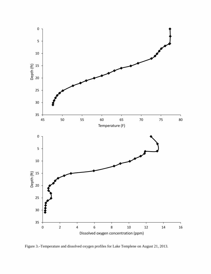
Figure 3.–Temperature and dissolved oxygen profiles for Lake Templene on August 21, 2013.
0
5
10
15
20
25
30
35
45 50 55 60 65 70 75 80
De
pth
(ft
)
Temperature (F)
0
5
10
15
20
25
30
35
0 2 4 6 8 10 12 14 16
De
pth
(ft
)
Dissolved oxygen concentration (ppm)

Figure 4.–Length frequency distributions for bluegills captured in Lake Templene using trap nets and large-mesh fyke nets, nighttime electrofishing gear, and all gear types during April 29-May 2, 2013.
0
200
400
600
800
1000
1 2 3 4 5 6 7 8
Nu
mb
er
of
fish
Total length (inches)
Trap Nets and Large-Mesh Fyke Nets
n = 1,852
0
50
100
150
200
250
1 2 3 4 5 6 7 8
Nu
mb
er
of
fish
Total length (inches)
Electrofishing
n = 772
0
200
400
600
800
1000
1 2 3 4 5 6 7 8
Nu
mb
er
of
fish
Total length (inches)
All Gear Types
n = 3,504

Figure 5.–Growth of bluegills in Lake Templene, as determined from scale and anal spine samples collected during April 29-May 2, 2013. State average lengths are from Schneider et al. (2000a).
0
1
2
3
4
5
6
7
8
9
0 1 2 3 4 5 6
Tota
l le
ng
th (
inch
es)
Age (years)
Lake Templene Mean Length-at-Age
State Average

Figure 6.–Age frequency distribution for bluegills captured in Lake Templene during April 29-May 2, 2013.
Figure 7.–Natural log of observed numbers of fish versus age for bluegills captured in Lake Templene during April 29-May 2, 2013.
0
5
10
15
20
25
30
35
40
45
1 2 3 4 5 6 7 8 9
Pe
rce
nt
of
catc
h
Age (years)
0
1
2
3
4
5
6
7
8
9
0 1 2 3 4 5 6 7 8
Ln(N
um
be
r)
Age (years)
Ln(Number) = 9.3851 - 0.9573 * Age
R² = 0.81, P = 0.039
Annual mortality = 62%

Figure 8.–Length frequency distribution for black crappies captured in Lake Templene during April 29-May 2, 2013.
Figure 9.–Age frequency distribution for black crappies captured in Lake Templene during April 29-May 2, 2013.
0
20
40
60
80
100
120
140
160
180
3 4 5 6 7 8 9 10 11 12
Nu
mb
er
of
fish
Total length (inches)
n = 422
0
5
10
15
20
25
30
35
40
1 2 3 4 5 6 7 8 9 10 11
Pe
rce
nt
of
catc
h
Age (years)

Figure 10.–Growth of black crappies in Lake Templene, as determined from scale and anal spine samples collected during April 29-May 2, 2013. State average lengths from Schneider et al. (2000a).
0
2
4
6
8
10
12
0 1 2 3 4 5 6 7
Tota
l le
ng
th (
inch
es)
Age (years)
Lake Templene Mean Length-at-Age
State Average

Figure 11.–Length frequency distributions for pumpkinseeds and yellow perch captured in Lake Templene during April 20-May 2, 2013.
0
5
10
15
20
25
30
35
40
45
50
1 2 3 4 5 6 7 8 9 10
Nu
mb
er
of
fish
Total length (inches)
Pumpkinseeds
n = 115
0
2
4
6
8
10
12
14
16
18
20
1 2 3 4 5 6 7 8 9 10
Nu
mb
er
of
fish
Total length (inches)
Yellow Perch
n = 73

Figure 12.–Growth of pumpkinseeds in Lake Templene, as determined from scale and anal spine samples collected during April 29-May 2, 2013. State average lengths from Schneider et al. (2000a).
0
1
2
3
4
5
6
7
8
9
0 1 2 3 4 5 6
Tota
l le
ng
th (
inch
es)
Age (years)
Lake Templene
State Average
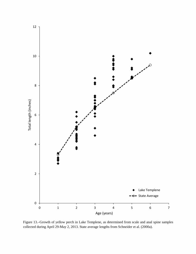
Figure 13.–Growth of yellow perch in Lake Templene, as determined from scale and anal spine samples collected during April 29-May 2, 2013. State average lengths from Schneider et al. (2000a).
0
2
4
6
8
10
12
0 1 2 3 4 5 6 7
Tota
l le
ng
th (
inch
es)
Age (years)
Lake Templene
State Average

Figure 14.–Age frequency distributions for pumpkinseeds and yellow perch captured in Lake Templene during April 29-May 2, 2013.
0
5
10
15
20
25
30
35
1 2 3 4 5 6
Pe
rce
nt
of
catc
h
Age (years)
Pumpkinseeds
0
5
10
15
20
25
30
35
40
1 2 3 4 5 6
Pe
rce
nt
of
catc
h
Age (years)
Yellow Perch

Figure 15.–Length frequency distribution for largemouth bass captured in Lake Templene during April 29-May 2, 2013.
Figure 16.–Age frequency distribution for largemouth bass captured in Lake Templene during April 29-May 2, 2013.
0
2
4
6
8
10
12
14
16
18
20
2 3 4 5 6 7 8 9 10 11 12 13 14 15 16
Nu
mb
er
of
fish
Total length (inches)
n = 99
0
5
10
15
20
25
30
35
1 2 3 4 5 6 7 8
Pe
rce
nt
of
catc
h
Age (years)

Figure 17.–Growth of largemouth bass in Lake Templene, as determined from scale and anal spine samples collected during April 29-May 2, 2013. State average lengths from Schneider et al. (2000a).
0
2
4
6
8
10
12
14
16
18
0 1 2 3 4 5 6 7 8
Tota
l le
ng
th (
inch
es)
Age (years)
Lake Templene Mean Length-at-Age
State Average
Minimum size limit
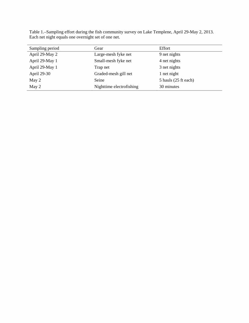
Table 1.–Sampling effort during the fish community survey on Lake Templene, April 29-May 2, 2013. Each net night equals one overnight set of one net. Sampling period Gear Effort April 29-May 2 Large-mesh fyke net 9 net nights
April 29-May 1 Small-mesh fyke net 4 net nights
April 29-May 1 Trap net 3 net nights
April 29-30 Graded-mesh gill net 1 net night
May 2 Seine 5 hauls (25 ft each)
May 2 Nighttime electrofishing 30 minutes
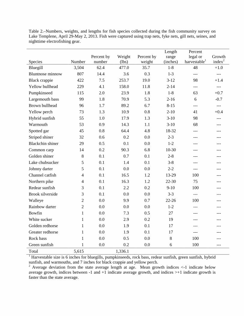
Table 2.–Numbers, weights, and lengths for fish species collected during the fish community survey on Lake Templene, April 29-May 2, 2013. Fish were captured using trap nets, fyke nets, gill nets, seines, and nighttime electrofishing gear.
Species Number Percent by
number Weight
(lbs) Percent by
weight
Length range
(inches)
Percent legal or
harvestable1 Growth index2
Bluegill 3,504 62.4 477.0 35.7 1-8 48 +1.0
Bluntnose minnow 807 14.4 3.6 0.3 1-3 --- ---
Black crappie 422 7.5 253.7 19.0 3-12 98 +1.4
Yellow bullhead 229 4.1 158.0 11.8 2-14 --- ---
Pumpkinseed 115 2.0 23.9 1.8 1-8 63 +0.7
Largemouth bass 99 1.8 70.9 5.3 2-16 6 -0.7
Brown bullhead 96 1.7 89.2 6.7 8-15 --- ---
Yellow perch 73 1.3 10.9 0.8 2-10 41 +0.4
Hybrid sunfish 55 1.0 17.9 1.3 3-10 98 ---
Warmouth 53 0.9 14.3 1.1 3-10 68 ---
Spotted gar 45 0.8 64.4 4.8 18-32 --- ---
Striped shiner 32 0.6 0.2 0.0 2-3 --- ---
Blackchin shiner 29 0.5 0.1 0.0 1-2 --- ---
Common carp 14 0.2 90.3 6.8 10-30 --- ---
Golden shiner 8 0.1 0.7 0.1 2-8 --- ---
Lake chubsucker 5 0.1 1.4 0.1 3-8 --- ---
Johnny darter 5 0.1 0.0 0.0 2-2 --- ---
Channel catfish 4 0.1 16.5 1.2 13-29 100 ---
Northern pike 4 0.1 16.3 1.2 22-30 75 ---
Redear sunfish 3 0.1 2.2 0.2 9-10 100 ---
Brook silverside 3 0.1 0.0 0.0 3-3 --- ---
Walleye 2 0.0 9.9 0.7 22-26 100 ---
Rainbow darter 2 0.0 0.0 0.0 1-2 --- ---
Bowfin 1 0.0 7.3 0.5 27 --- ---
White sucker 1 0.0 2.9 0.2 19 --- ---
Golden redhorse 1 0.0 1.9 0.1 17 --- ---
Greater redhorse 1 0.0 1.9 0.1 17 --- ---
Rock bass 1 0.0 0.5 0.0 8 100 ---
Green sunfish 1 0.0 0.2 0.0 6 100 ---
Total 5,615 1,336.1 1 Harvestable size is 6 inches for bluegills, pumpkinseeds, rock bass, redear sunfish, green sunfish, hybrid sunfish, and warmouths, and 7 inches for black crappie and yellow perch. 2 Average deviation from the state average length at age. Mean growth indices <-1 indicate below average growth, indices between -1 and +1 indicate average growth, and indices >+1 indicate growth is faster than the state average.