military road safety improvements
TRANSCRIPT

1
Military Road Safety Improvements
June 10, 2021
Dan NaborsAssistant Bureau Chief, TE&O
Jason WidstromProgram Manager, TPCPM
Nate GrahamPublic Engagement, DES
Gabriela KockProject Manager, TPCPM

2
Meeting Agenda• Introduction• Project Background and Goals• Project Update:
1. Marcey Road2. 36th Street N. / Gulf Branch Trail
• Project Update: Military Road and Nelly Custis Drive
• Safety Concerns• Existing Conditions• Past Engagement• Next Steps
• Question & Answer

Questions? Concerns?
Gabriela Kock, Capital Project [email protected]
Dan Nabors, Asst. TE&O Bureau [email protected]
Jason Widstrom, Capital Projects [email protected]
Nate Graham, Public Engagement [email protected]
How This Works:For questions during this presentation• Ask us questions anytime during the presentation
using the Live Event Q&A− The project team are ready to respond as
needed- We’ll let you know if your question will be
answered in the presentation or in the Q&A- We’ll respond directly to specific or clarifying
questions as possible.
How to ask questions during the presentation:

4
Project Location

5
Project Background• Military Road is a corridor included in the 2004
Arterial Transportation Management Study• The study covered 11 corridors in the County
that experienced high vehicle speeds, collisions, and limited pedestrian infrastructure
• Recommendations for the corridor included:– Eliminate one travel lane in each direction – Install bicycle lanes and parking boxes along the
corridor– Install medians at key crossings and provide
additional crossing points through the corridor.

6
Project Background
• Historical speed counts show average speeds through the corridor are 10 miles above the posted speed limit (30 mph).
• People use Military Road for walking and biking but have few opportunities to cross the road safely.
• The pandemic has pushed us all to spend more time outdoors.

7
• Improve conditions for safe pedestrian crossing at corridor intersections
• Improve existing bicycle and pedestrian facilities
• Reduce impervious surface when possible
Military Road Corridor Goals:

8
• Fall 2017 public meeting at Gulf Branch Nature Center
• Residents supported safety improvements at 36th Road N and Marcey Road but there were additional questions on Military Road.
• A 2017-2018 online survey asked residents to provide input on alternatives for Military and Nelly Custis:– Roundabout– Traffic signal– No change
Past Engagement

9
Military Road and Nelly Custis Drive: Intersection Alternatives
Roundabout Signalized Intersection

10
Completed Safety Improvements• In Fall 2020 Arlington County completed safety
improvements at two intersections:36th Rd N
Marcey Rd

11
Past Engagement – Survey Results
Total number of responses during 5-week period = 121

12
Project Location

13
Military Road and Nelly Custis Drive
Why is DES focusing on this intersection?
• The intersection covers a very large area with just one crosswalk
• Few vehicles yield to pedestrians on Nelly Custis Dr
• Increase the number of pedestrian crossing options at the intersection
• School walk zones have expanded significantly

14
Military and Nelly Custis: Existing conditions

15
Average Daily Traffic Volumes – 2019
Posted Speed Limit: 30 mph25 mph for school zones

16
Social distancing guidelines reduced bus service availability and expanded walk zones for Taylor Elementary School

17
As well as Dorothy Hamm Middle School. Both expanded walk zones cover the intersection of Military Road and Nelly Custis
18
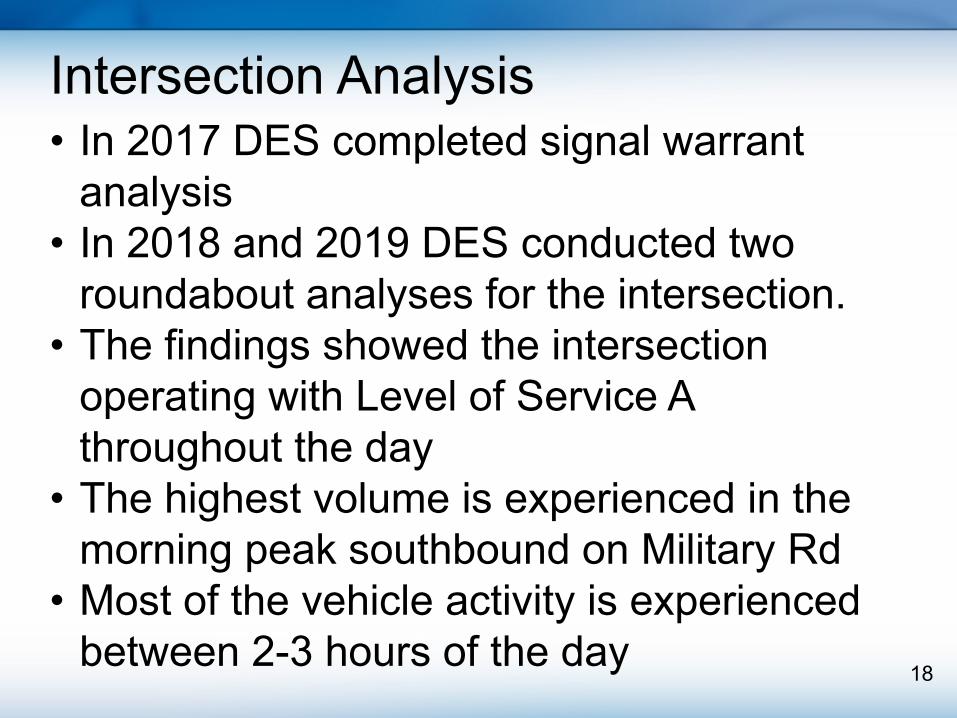
• In 2017 DES completed signal warrant analysis
• In 2018 and 2019 DES conducted two roundabout analyses for the intersection.
• The findings showed the intersection operating with Level of Service A throughout the day
• The highest volume is experienced in the morning peak southbound on Military Rd
• Most of the vehicle activity is experienced between 2-3 hours of the day
Intersection Analysis

19
• Increase driver yield rates• Shorten crossing distances for people
walking through intersection• Provide predictable vehicle turning
movements • Reduce vehicle speeding• The roundabout will increase safety for all
users!
Temporary Roundabout Pilot Project at Military Road and Nelly Custis Drive

20
• Why a pilot project?– Temporary materials, rapid installation– Data collection of real-world conditions– Ability to change, adjust as needed, remove if
it doesn’t work– Utilities make permanent change a long-term
process– Part of Vision Zero best practices
Temporary Roundabout Pilot Project at Military Road and Nelly Custis Drive

21
Conflicts at Intersection vs. Roundabout

22
Conflicts at Intersection vs. Roundabout
12 6

23
Pedestrian Movements at Roundabouts

24
Roundabouts are a Safer Option
• Intersections converted to a roundabout result in a 27% reduction of pedestrian crashes
• Conversion from stop-controlled intersection- 82% reduction in injury crashes

25

26
• Pilot Project Timeline–Install anticipated: Summer 2021–Analysis period: 1 year–Report back: 6 to 8 months
Temporary Roundabout Pilot Project at Military Road and Nelly Custis Drive

27
Q&A

28