mgm springfield tarp redevelopment llc (“mgm springfield”) 1414 main street, suite 1140...
TRANSCRIPT

ENVIRONMENTAL NOTIFICATION FORM
Submitted to:Executive Office of Energyand Environmental Affairs
MEPA Office100 Cambridge Street, Suite 900
Boston, MA 02114
Submitted by:Blue Tarp reDevelopment LLC (“MGM Springfield”)
1414 Main Street, Suite 1140Springfield, MA 0114
Prepared by:Epsilon Associates, Inc.3 Clock Tower Place, Suite 250Maynard, MA 01754
In association with:Davenport CompaniesTraffic Engineering Consultants, Inc.Sanborn, Head & Associates, Inc.Allen & Major Associates, Inc.Brown Rudnick, LLP
March 15, 2013
MGM Springfield

Environmental Notification Form

Commonwealth of Massachusetts Executive Office of Energy and Environmental Affairs
Massachusetts Environmental Policy Act (MEPA) Office
Effective January 2011
Environmental Notification Form
For Office Use Only
EEA#: MEPA Analyst:
The information requested on this form must be completed in order to submit a document electronically for review under the Massachusetts Environmental Policy Act, 301 CMR 11.00.
Project Name: MGM Springfield Street Address: Main Street Municipality: Springfield Watershed: Connecticut River Universal Transverse Mercator CoordinUTM Zone 18, 699569E, 4663629N
Latitude: 42° 5' 57.7854" Longitude: -72° 35' 11.6376"
Estimated commencement date: As determined by the application process with the Massachusetts Gaming Commission
Estimated completion date: Construction is expected to last 27 to 30 months once permits and approvals have been obtained.
Project Type: Multi-Use Status of project design: 10 %complete Proponent: Blue Tarp reDevelopment LLC (“MGM Springfield”) Street Address: 1414 Main Street, Suite 1140 Municipality: Springfield State: MA Zip Code: 01144 Name of Contact Person: Corinne Snowdon Firm/Agency: Epsilon Associates, Inc. Street Address: 3 Clock Tower Place, Suite 250 Municipality: Maynard State: MA Zip Code: 01754 Phone: (978) 897-7100 Fax: (978) 897-0099 E-mail:
[email protected] Does this project meet or exceed a mandatory EIR threshold (see 301 CMR 11.03)? Yes No If this is an Expanded Environmental Notification Form (ENF) (see 301 CMR 11.05(7)) or a Notice of Project Change (NPC), are you requesting: a Single EIR? (see 301 CMR 11.06(8)) Yes No a Special Review Procedure? (see 301CMR 11.09) Yes No a Waiver of mandatory EIR? (see 301 CMR 11.11) Yes No a Phase I Waiver? (see 301 CMR 11.11) Yes No (Note: Greenhouse Gas Emissions analysis must be included in the Expanded ENF.) Which MEPA review threshold(s) does the project meet or exceed (see 301 CMR 11.03)? 301 CMR 11.03(1)(b)3 – Conversion of land held for natural resources purposes in accordance with Article 97 of the Amendments to the Constitution of the Commonwealth to any purpose not in accordance with Article 97. 301 CMR 11.03(1)(b)6 – Approval in accordance with M.G.L. c. 121A of a New urban redevelopment project or a fundamental change in an approved urban redevelopment project, provided that the Project consists of 100 or more dwelling units or 50,000 or more square feet of non-residential use.

- 2 -
301 CMR 11.03(1)(b)7 – Approval in accordance with M.G.L. c. 121B of a New urban renewal plan or major modification of an existing urban renewal plan. 301 CMR 11.03(5)(b)4.a – New discharge or expansion of discharge to a sewer system of 100,000 or more gpd; 301 CMR 11.03(6)(a)6 – Generation of 3,000 or more New adt; 301 CMR 11.03(6)(a)7 – Construction of 1,000 or more New parking spaces at a single location; 301 CMR 11.03(6)(b)13 – New adt of 2,000 or more on roadways providing access to a single location; 301 CMR 11.03(6)(b)14 – Generation of 1,000 or more New adt on roadways providing access to a single location and construction of 150 or more New parking spaces at a single location; 301 CMR 11.03(6)(b)15 – Construction of 300 or more New parking spaces at a single location; 301 CMR 11.03(6)(b)2.b - Cut five or more living public shade trees of 14 or more inches in diameter at breast height; 301 CMR 11.03(10)(b)1 – Demolition of all or any exterior part of any Historic Structure listed in or located in any Historic District listed in the State Register of Historic Places or the Inventory of Historic and Archaeological Assets of the Commonwealth. Which State Agency Permits will the project require? The Project will or may require the following permits: Massachusetts Gaming Commission – Gaming License Massachusetts Department of Transportation – Highway Access Permit Department of Environmental Protection – Sewer Connection Permit Department of Environmental Protection – Construction Dewatering Permit Department of Environmental Protection – Chapter 91 License Department of Public Safety – Storage Permit Division of Fish and Game – Conservation and Management Permit Department of Housing & Community Development – Urban renewal plan or urban redevelopment project approval under M.G.L. c. 121A or M.G.L. c. 121B Identify any financial assistance or land transfer from an Agency of the Commonwealth, including the Agency name and the amount of funding or land area in acres: None
- 3 -
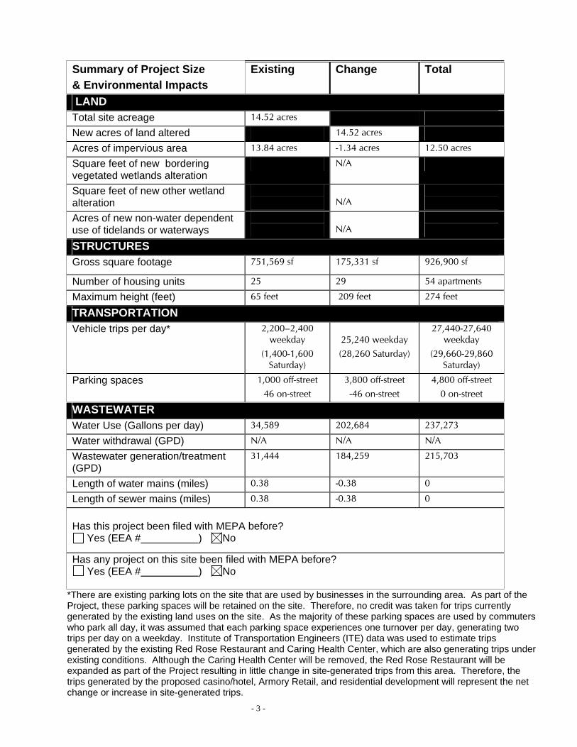
Summary of Project Size & Environmental Impacts
Existing Change Total
LAND Total site acreage 14.52 acres
New acres of land altered 14.52 acres
Acres of impervious area 13.84 acres -1.34 acres 12.50 acres
Square feet of new bordering vegetated wetlands alteration
N/A
Square feet of new other wetland alteration
N/A
Acres of new non-water dependent use of tidelands or waterways
N/A
STRUCTURES Gross square footage 751,569 sf 175,331 sf 926,900 sf
Number of housing units 25 29 54 apartments
Maximum height (feet) 65 feet 209 feet 274 feet
TRANSPORTATION Vehicle trips per day* 2,200–2,400
weekday (1,400-1,600
Saturday)
25,240 weekday (28,260 Saturday)
27,440-27,640 weekday
(29,660-29,860 Saturday)
Parking spaces 1,000 off-street 46 on-street
3,800 off-street -46 on-street
4,800 off-street 0 on-street
WASTEWATER Water Use (Gallons per day) 34,589 202,684 237,273
Water withdrawal (GPD) N/A N/A N/A
Wastewater generation/treatment (GPD)
31,444 184,259 215,703
Length of water mains (miles) 0.38 -0.38 0
Length of sewer mains (miles) 0.38 -0.38 0
Has this project been filed with MEPA before?
Yes (EEA # ) No
Has any project on this site been filed with MEPA before? Yes (EEA # ) No
*There are existing parking lots on the site that are used by businesses in the surrounding area. As part of the Project, these parking spaces will be retained on the site. Therefore, no credit was taken for trips currently generated by the existing land uses on the site. As the majority of these parking spaces are used by commuters who park all day, it was assumed that each parking space experiences one turnover per day, generating two trips per day on a weekday. Institute of Transportation Engineers (ITE) data was used to estimate trips generated by the existing Red Rose Restaurant and Caring Health Center, which are also generating trips under existing conditions. Although the Caring Health Center will be removed, the Red Rose Restaurant will be expanded as part of the Project resulting in little change in site-generated trips from this area. Therefore, the trips generated by the proposed casino/hotel, Armory Retail, and residential development will represent the net change or increase in site-generated trips.

- 4 -
GENERAL PROJECT INFORMATION – all proponents must fill out this section PROJECT DESCRIPTION: Describe the existing conditions and land uses on the project site: The Project site is bounded by Main Street to the north, Union Street to the east, East Columbus Avenue to the south, and State Street to the west. In addition, the Project site encompasses portions of Bliss Street and Howard Street within the site boundaries. The Project site consists of several buildings and a number of vacant lots, a majority of which are being used as surface parking lots. Typical of an urban area, the buildings on site offer a variety of uses including commercial, retail and residential space. Portions of the Project site suffered significant damage in the June 2011 tornado. Attachment 2 is a USGS map showing the location of the Project site, and Attachment 3 is an Existing Conditions Plan. Attachment 4 shows environmental constraints in the vicinity of the Project site. Describe the proposed project and its programmatic and physical elements: NOTE: The project description should summarize both the project’s direct and indirect impacts (including construction period impacts) in terms of their magnitude, geographic extent, duration and frequency, and reversibility, as applicable. It should also discuss the infrastructure requirements of the project and the capacity of the municipal and/or regional infrastructure to sustain these requirements into the future. The Project is a multi-use development anchored by a casino that will serve as a significant economic catalyst for the City of Springfield and the surrounding area. The Project will consist of two separate “blocks” of development, referred to as the “Casino Block” and the “Retail Block.” The Casino Block will house an approximately 201,820 sf hotel, 126,701 sf of casino gaming facilities, 7,682 sf of retail space, 48,131 sf of restaurant space, 55,584 of convention space, 9,437 sf of office space, and 54 residential apartments, as shown on Attachment 5. The Retail Block will consist of an approximately 139,888 sf multi-use facility that will include a bowling alley, retail/restaurant space, and cinema. The retail will open to the street in an effort to invigorate the surrounding streetscape and create a vibrant urban environment for the City and its residents. Not including parking, the Project’s gross total area is approximately 926,900. To meet the demand expected to be created by the Project, there will be approximately 4,800 parking spaces on-site located in an eight story parking structure. Given the Project’s location on a previously developed urban site, natural resource impacts are expected to be minimal. Describe the on-site project alternatives (and alternative off-site locations, if applicable), considered by the proponent, including at least one feasible alternative that is allowed under current zoning, and the reasons(s) that they were not selected as the preferred alternative: NOTE: The purpose of the alternatives analysis is to consider what effect changing the parameters and/or siting of a project, or components thereof, will have on the environment, keeping in mind that the objective of the MEPA review process is to avoid or minimize damage to the environment to the greatest extent feasible. Examples of alternative projects include alternative site locations, alternative site uses, and alternative site configurations. In addition to the Project site in Springfield currently being proposed, the Proponent also considered developing land in Brimfield, Massachusetts. However, after detailed evaluation of this

- 5 -
alternative site, the Proponent found that the Springfield site was a more appropriate location for the Project. The Brimfield site had a number of concerns as it consisted mostly of previously undeveloped land and would have involved significant impacts to wetland resource areas. , infrastructure, and developing in proximity to mapped Priority Habitat. The Proponent performed a thorough and systematic search for a suitable Project site resulting in the choice of the current proposed location in Springfield. Among the criteria considered in the search were: access to and from major roadways; adequate site size; local economic development goals; compatible land use; adequate water, sewer, and telecommunications infrastructure; and the ability to minimize natural resource impacts. Of the sites potentially available to the Proponent, the Project site was found to best meet the search criteria and to have the least environmental impact. Summarize the mitigation measures proposed to offset the impacts of the preferred alternative: As described below, the Project’s key mitigation measures will be in the areas of transportation and cultural resources. In consultation with the City of Springfield, the Proponent will determine whether mitigation for the Project’s potential impacts to water supply, wastewater or stormwater infrastructure will require mitigation. As the process progresses the Proponent will enter into a more detailed agreement with the local municipality centered on specific public benefits and how the Project can best contribute towards improving the local community. Transportation Infrastructure
TEC, Inc. conducted a preliminary traffic impact assessment to assess the potential traffic impacts of the Project on the intersections immediately surrounding the Project site as part of a Request for Proposal (RFP) process with the City of Springfield. A copy of this report is included as Attachment 8 to this ENF. Based on the preliminary findings of the report, TEC has identified roadway improvements that will be constructed by the Proponent to mitigate the impacts of the Project on the intersections included in the study area. These improvements include: I-91 Southbound Exit 6
o Modify the barrier at the end of the I-91 southbound off-ramp and replace with guardrail to improve motorist sight distance at the merge area.
o Install vehicle queue detectors on the I-91 southbound off-ramp that will be wired to the traffic signal controller at the intersection of West Columbus Avenue / Union Street. These will be used to monitor traffic conditions and provide an extended green interval, if necessary.
Union Street o Reconstruct the curb lines on Union Street under the I-91 overpass bridge to
accommodate five travel lanes where four exist today. The work can be completed between the existing bridge piers by implementing 10-foot wide left-turn lanes and 11-foot wide through lanes with 2-foot side shoulders (56 feet curb-to-curb). This may require adjustments to the bridge pier footings.
o Perform partial traffic signal reconstruction at the intersections of East Columbus Avenue/ Union Street and West Columbus Avenue/ Union Street and improve signal phasing. The exclusive pedestrian phasing to cross West Columbus Avenue will be converted to concurrent operations, whereby pedestrians will walk at the same time as the parallel traffic. The phasing will be modified to move, or clear, traffic through the two intersections with limited potential for blocking.
o Perform minor curb work and restripe the Union Street westbound approach to East Columbus Avenue to accommodate one through lane and one shared through-right lane.

- 6 -
The eastbound receiving area will be limited to one lane. Additional lane use signs will be installed to direct motorists to the appropriate lanes.
o Install raised reflectorized stanchions along the painted centerline on Union Street and install regulatory signs to limit access into the self-park garage to right-in and right-out. The self-park exit will be signed as a one-way exit.
East Columbus Avenue o Improve the corner radii between East Columbus Avenue and Bliss Street to more
efficiently process patron traffic entering and exiting the self-park garages. o Construct a 12-foot shoulder along East Columbus Avenue, between Howard Street and
Bliss Street, to allow for acceleration and deceleration maneuvers associated with garage access.
o Perform minor improvements to the alignment of the channelizing islands on East Columbus Avenue as it approaches the northerly Exit 7 on-ramp to I-91 northbound (just north of State Street).
State Street o Remove the existing on-street parking on State Street and resurface and restripe the
pavement to accommodate a 10-foot left-turn lane into the hotel drop-off/valet parking area.
o Restripe a right-turn lane on State Street eastbound approach to Main Street within the existing curb lines. This better utilizes the existing pavement area.
Modify signal phasing and implement new coordination timing plans for the intersections of East and West Columbus Avenues with State Street and Union Street to improve traffic flow between intersections.
Perform pedestrian facility improvements along the Main Street, State Street, and Union Street corridors and all roadways internal to the Project. This includes upgrades to the bus stops and shelters that lie in front of the site along Main Street.
Work with MassDOT to deploy variable message signs on I-91 and I-291 to notify motorists of traffic conditions in the downtown area. These would be used to inform the public of varying traffic conditions for all downtown events, including the casino.
Use on-site wayfinding signs to direct patrons to the access and egress points that are most efficient for the intended destination.
Coordinate the traffic signals and improve vehicle detection along Dwight Street, if necessary, to improve the flow of patron traffic from I-291.
Construct a pedestrian bridge between the Project site and the MassMutual Convention Center. This is dependent upon a pending architectural feasibility assessment.
The preliminary traffic study included an analysis of traffic impacts for a limited study area and did not include analysis of the merging and diverging movements exiting and entering the I-91 and I-291 ramps providing access to the site. For the Environmental Impact Report (EIR), the Proponent will conduct additional analysis for a broader study area of the Commonwealth’s facilities. The following provides a summary of the scope of work that is anticipated for preparation of the Transportation section of the Draft EIR.
Conduct capacity and queue analysis under Existing, No-Build, Build, and Build with
Mitigation conditions to determine the impacts of the Project on the following intersections: o Union Street / West Union Street / West Columbus Avenue o Union Street / East Columbus Avenue o Union Street / Southerly Parking Garage Exit Driveway (proposed) o Union Street / Charter Bus Driveway (proposed) o Union Street / Armory Square Westerly Driveway (proposed) o Union Street / Armory Square Easterly Driveway (proposed) o Union Street / Main Street

- 7 -
o Howard Street / East Columbus Avenue o Howard Street (future Armory Square Northerly Driveway) / Main Street o Bliss Street / East Columbus Avenue o Bliss Street / Main Street o State Street / West Columbus Avenue o State Street / East Columbus Avenue o State Street / Resort Northerly Driveway o State Street / Main Street o State Street / Dwight Street o State Street / Chestnut Street / Maple Street o Memorial Bridge / Boland Way / West Columbus Avenue o Boland Way / East Columbus Avenue o I-291 SB Exit 2 Off-Ramp / I-91 NB On-Ramp / Dwight Street
Conduct analysis under Existing, No-Build, Build, and Build with Mitigation conditions for the following merge and diverge locations: o I-91 NB Exit 5 Off-Ramp Diverge (south of York Street) o I-91 NB Exit 5 Off-Ramp Merge with East Columbus Avenue (south of York Street) o I-91 NB Exit 6 Off-Ramp Diverge (south of Margaret Street) o I-91 NB Exit 6 Off-Ramp Merge with East Columbus Avenue (south of Margaret Street) o I-91 NB Exit 6 On-Ramp Merge (north of Union Street) o I-91 NB Exit 7 On-Ramp Merge (north of State Street) o I-91 NB Exit 8 Diverge to I-291 NB o I-91 SB Exit 7 Diverge to West Columbus Avenue (north of Memorial Bridge) o I-91 SB Merge with I-291 SB (north of Memorial Bridge) o I-91 SB Exit 6 Off-Ramp Diverge (north of Union Street) o I-91 SB Exit 6 On-Ramp Merge (south of Union Street) o I-291 NB Exit 2B Off-Ramp Diverge to Dwight Street o I-291 NB Exit 2 Off-Ramp Diverge to Chestnut Street o I-291 NB Exit 2 On-Ramp Merge from Dwight Street o I-291 NB Exit 2 On-Ramp Merge from Chestnut Street o I-291 NB Merge from I-91 SB and I-91 NB o I-291 SB Exit 2/Exit 1A Diverge to Chestnut Street / I-91 SB o I-291 SB Exit 2A Diverge to Dwight Street o I-291 SB Exit 2 On-Ramp Merge from Dwight Street to I-91 NB
Conduct analysis under Existing, No-Build, Build, and Build with Mitigation conditions for the following weaving sections: o I-91 SB between I-291 SB On-Ramp and I-91 SB Exit 6 Off-Ramp o West Columbus Avenue between I-91 SB Exit 6 Off-Ramp and I-91 SB Exit 6 On-Ramp o East Columbus Avenue between I-91 NB Exit 6 Off-Ramp and I-91 NB Exit 6 On-Ramp
Transportation Demand Management
To reduce single-occupancy vehicle trips generated by the Project, MGM will implement a transportation demand management (TDM) program to maximize employee vehicle occupancy and thereby reduce the vehicular demand on the site. Many other services can allow for multi-modal options for patrons. The Proponent will evaluate rideshare programs, subsidized transit fares with the Pioneer Valley Transit Authority (PVTA), airport shuttle services, guest shuttle services to the Amtrak Station and area attractions, and zip car availability for hotel guests. A number of TDM measures are proposed to reduce vehicle trips and better manage traffic generated by the proposed Project, which include the following:

- 8 -
Transit Measures: o Locate development in close proximity to PVTA bus and Amtrak services, including
Union Station o Provide shuttle bus or trolley service between development, Union Station, and local
attractions o Offer transit subsidies for employees
Pedestrian and Bicycle Treatments: o Provide on-site bicycle racks o Provide bicycles and equipment for employees o Provide showers for employees that commute by walking or biking o Reconstruct sidewalks along study area roadways to improve pedestrian access
Parking Measures: o Provide a reduced valet rate for vehicles with three or more patrons o Provide preferential parking for rideshare and carpool o Provide charging stations for electric vehicles o Implement an IT System to direct drivers to open parking spaces
Other Measures: o Maintain major employee shift times that are outside the traditional downtown peak
hours of 7:00 a.m. to 9:00 a.m. and 4:00 p.m. to 6:00 p.m. o Provide a Transportation Coordinator on-site o Encourage vanpool and carpooling programs o Provide and update a monthly Commuter Bulletin o Facilitate events through coordination with MassRIDES and PVTA o Consider providing Zip Cars for employee, resident, and hotel guest use.
Parking
Based on recent field counts, there are exactly 1,000 existing off-street parking spaces and 46 on-street parking spaces that would be eliminated as part of the Project. These are currently used by employees and patrons of area businesses which will remain operational following redevelopment of the site. The Proponent is providing off-street parking in a structured parking lot for 4,850 parking spaces. The Project will experience its heaviest parking demand on a Friday or Saturday evening, and will experience significantly lower parking demand during a normal weekday. As such, the Proponent will allow the on-site parking spaces to be used by surrounding businesses during the day when casino parking demand is low. This will mitigate the displacement of parking to other garages and off-street parking facilities in the area.
Other Infrastructure Systems
The Proponent will consult with the City of Springfield on any necessary improvements to the water and wastewater infrastructure in the vicinity of the Project site.
If the project is proposed to be constructed in phases, please describe each phase: The Project is not proposed to be constructed in phases.

- 9 -
AREAS OF CRITICAL ENVIRONMENTAL CONCERN: Is the project within or adjacent to an Area of Critical Environmental Concern?
Yes (Specify__________________________________) No
if yes, does the ACEC have an approved Resource Management Plan? ___ Yes ___ No; If yes, describe how the project complies with this plan. _______________________________________________________ Will there be stormwater runoff or discharge to the designated ACEC? ___ Yes ___ No; If yes, describe and assess the potential impacts of such stormwater runoff/discharge to the designated ACEC. _________________________________________________
RARE SPECIES: Does the project site include Estimated and/or Priority Habitat of State-Listed Rare Species? (see http://www.mass.gov/dfwele/dfw/nhesp/regulatory_review/priority_habitat/priority_habitat_home.htm)
Yes (Specify__ _) No
Further analysis will occur during preparation of the Environmental Impact Report.
HISTORICAL /ARCHAEOLOGICAL RESOURCES: Does the project site include any structure, site or district listed in the State Register of Historic Place or the inventory of Historic and Archaeological Assets of the Commonwealth? Yes (Specify__________________________________ ) No
A review of the Massachusetts Historical Commission’s (MHC’s) files indicates the Project site encompasses four properties listed on the State and National Registers of Historic Places, three properties listed on the State Register of Historic Places with formal Determinations of Eligibility (DOE), and three properties included in the Inventory of Historic and Archaeological Assets of the Commonwealth, of which one has been demolished: WCA Boarding House, French Congregational Church, State Armory, United Electric Company, Young Women’s Christian Association, Massachusetts Mutual Life Insurance Company, Edsonia Theater Block, Howard Primary School, Union House/Chandler Hotel, Howard Street Apartment Building, and David Bush House (demolished).
If yes, does the project involve any demolition or destruction of any listed or inventoried historic or archaeological resources? Yes (Specify__________________________________) No
The Proponent anticipates using a variety of treatment approaches to the extant historic buildings within the Project site, including reuse in situ, relocation and reuse, reuse of portions of buildings, and demolition. An analysis is being undertaken of each of the historic buildings’ conditions, including structural integrity, and their feasibility for reuse within the anticipated programming and design. The results of the analysis will be used to guide decision-making regarding the disposition of each of the properties.
WATER RESOURCES: Is there an Outstanding Resource Water (ORW) on or within a half-mile radius of the project site? ___Yes X No; if yes, identify the ORW and its location. ___________________________________ (NOTE: Outstanding Resource Waters include Class A public water supplies, their tributaries, and bordering wetlands; active and inactive reservoirs approved by MassDEP; certain waters within Areas of CriticalEnvironmental Concern, and certified vernal pools. Outstanding resource waters are listed in the Surface Water Quality Standards, 314 CMR 4.00.)

- 10 -
Are there any impaired water bodies on or within a half-mile radius of the project site? X Yes ___No; if yes, identify the water body and pollutant(s) causing the impairment:___________________________.
According to the MassDEP 2010 Integrated List of Waters (305(b)/303(d)), the Connecticut River is a Category 5 impaired body of water and is impaired for one or more uses and requiring a TMDL (impairment due to pollutant(s) such as nutrients, metals, pesticides, solids and pathogens). The Connecticut River is located within a ½ mile of the Project site.
Is the project within a medium or high stress basin, as established by the Massachusetts Water Resources Commission? ___Yes X No STORMWATER MANAGEMENT: Generally describe the project's stormwater impacts and measures that the project will take to comply with the standards found in MassDEP's Stormwater Management Regulations: The following section outlines how the proposed stormwater management system will meet the standards in the Policy. The Project’s design will include the following best management practices:
Deep sump catch basins with hoods Hydro-dynamic (proprietary) Separators (Contech CDS®) Subsurface infiltration Bioretention areas Rainwater capture Specific maintenance schedule Restrictions on the use of pesticides, herbicides and fertilizers
Stormwater best management practices will be incorporated into the design of the Project to mitigate the anticipated pollutant loading. An Operations and Maintenance Plan has will be developed, which will address the long-term maintenance requirements of the proposed system. Temporary erosion and sedimentation controls will be incorporated into the construction phase of the Project. These temporary controls may include hay bale and/or silt fence barriers, inlet sediment traps, diversion channels, slope stabilization, and stabilized construction entrances. The Massachusetts Department of Environmental Protection has established ten Stormwater Management Standards. A project that meets or exceeds the standards is presumed to satisfy the regulatory requirements regarding stormwater management. The proposed stormwater management system will comply with the performance standards outlined in the MassDEP Stormwater Management Handbook. The Standards, and the Proponent’s approach to meeting the standards, are as follows:
STANDARD #1: No new stormwater conveyances (e.g. outfalls) may discharge untreated stormwater directly to or cause erosion in wetlands or waters of the Commonwealth.
The proposed redevelopment will not introduce any new outfalls with direct discharge to a wetland area or waters of the Commonwealth of Massachusetts. All discharges will be via existing outfall pipes and the rate and volumes will not be increased over existing conditions. STANDARD #2: Stormwater management systems shall be designed so that post-development peak discharge rates do not exceed pre-development peak discharge rates. This Standard may be waived for discharges to land subject to coastal storm flowage as defined in 310 CMR 10.04.

- 11 -
The Project will be designed so that the post-development peak discharge rates do not exceed the predevelopment peak discharge rates. STANDARD #3: Loss of annual recharge to groundwater shall be eliminated or minimized through the use of infiltration measures including environmentally sensitive site design, low impact development techniques, stormwater best management practices, and good operation and maintenance. At a minimum, the annual recharge from the post-development site shall approximate the annual recharge from pre-development conditions based on soil type. This Standard is met when the stormwater management system is designed to infiltrate the required recharge volume as determined in accordance with the Massachusetts Stormwater Handbook.
Subsurface infiltration systems will be proposed as part of the redevelopment. The proposed site improvements are classified as a “redevelopment” under the MassDEP Stormwater Management Standards. Consequently, compliance with Standard #3 must be to the maximum extent practicable. The site constraints, which include high groundwater and subsurface soil conditions may preclude the option of infiltration measures. However, the pre-development annual recharge for the site can be accomplished by the reduction of the impervious area within the Project site. STANDARD #4: Stormwater management systems shall be designed to remove 80% of the average annual post-construction load of Total Suspended Solids (TSS). This Standard is met when:
a. Suitable practices for source control and pollution prevention are identified in a long-term pollution prevention plan, and thereafter are implemented and maintained;
b. Structural stormwater best management practices are sized to capture the required water quality volume determined in accordance with the Massachusetts Stormwater Handbook; and
c. Pretreatment is provided in accordance with the Massachusetts Stormwater Handbook.
The proposed site improvements are classified as a “redevelopment” under the MassDEP Stormwater Management Standards. Consequently, compliance with Standard #4 must be to the maximum extent practicable. However, the proposed stormwater management system will be designed to meet the 80% TSS removal standard.
STANDARD #5: For land uses with higher potential pollutant loads, source control and pollution prevention shall be implemented in accordance with the Massachusetts Stormwater Handbook to eliminate or reduce the discharge of stormwater runoff from such land uses to the maximum extent practicable. If through source control and/or pollution prevention all land uses with higher potential pollutant loads cannot be completely protected from exposure to rain, snow, snow melt, and stormwater runoff, the proponent shall use the specific structural stormwater BMPs determined by the Department to be suitable for such uses as provided in the Massachusetts Stormwater Handbook. Stormwater discharges from land uses with higher potential pollutant loads shall also comply with the requirements of the Massachusetts Clean Waters Act, M.G.L. c. 21, §§ 26-53 and the regulations promulgated thereunder at 314 CMR 3.00, 314 CMR 4.00 and 314 CMR 5.00.
The site is considered a land use with higher potential pollutant loads. Source control and pollution prevention shall be implemented in accordance with the Massachusetts Stormwater Handbook to eliminate or reduce the discharge of stormwater runoff to the maximum extent practicable

- 12 -
STANDARD #6: Stormwater discharges within the Zone II or Interim Wellhead Protection Area of a public water supply, and stormwater discharges near or to any other critical area, require the use of the specific source control and pollution prevention measures and the specific structural stormwater best management practices determined by the Department to be suitable for managing discharges to such areas, as provided in the Massachusetts Stormwater Handbook. A discharge is near a critical area if there is a strong likelihood of a significant impact occurring to said area, taking into account site-specific factors. Stormwater discharges to Outstanding Resource Waters and Special Resource Waters shall be removed and set back from the receiving water or wetland and receive the highest and best practical method of treatment. A “storm water discharge” as defined in 314 CMR 3.04(2)(a)1 or (b) to an Outstanding Resource Water or Special Resource Water shall comply with 314 CMR 3.00 and 314 CMR 4.00. Stormwater discharges to a Zone I or Zone A are prohibited unless essential to the operation of a public water supply. The Project site will not discharge within a Zone II or Interim Wellhead Protection Area or near a critical area. Critical Areas are Outstanding Resource Waters as designated in 314 CMR 4.00, Special Resource Waters as designated in 314 CMR 4.00, recharge areas for public water supplies as defined in 310 CMR 22.02, bathing beaches as defined in 105 CMR 445.000, cold-water fisheries as defined in 314 CMR 9.02 and 310 CMR 10.04, and shellfish growing areas as defined in 314 CMR 9.02 and 310 CMR 10.04.
STANDARD #7: A redevelopment project is required to meet the following Stormwater Management Standards only to the maximum extent practicable: Standard 2, Standard 3, and the pretreatment and structural best management practice requirements of Standards 4, 5, and 6. Existing stormwater discharges shall comply with Standard 1 only to the maximum extent practicable. A redevelopment project shall also comply with all other requirements of the Stormwater Management Standards and improve existing conditions. The Project is considered a redevelopment project under the Stormwater Management Handbook guidelines as there is a decrease in the amount of total impervious area.
STANDARD #8: A plan to control construction-related impacts including erosion, sedimentation and other pollutant sources during construction and land disturbance activities (construction period erosion, sedimentation, and pollution prevention plan) shall be developed and implemented. A plan to control construction-related impacts, including erosion, sedimentation and other pollutant sources during construction and land disturbance activities will be developed. A detailed Erosion and Sedimentation Control Plan will be included in the Construction Drawings as well as a Pollution Prevention Plan. The Proponent will prepare and submit a Stormwater Pollution Prevention Plan (SWPPP) prior to commencement of construction activities that will result in the disturbance of one acre of land or more.
STANDARD #9: A long-term operation and maintenance plan shall be developed and implemented to ensure that stormwater management systems function as designed. A Long-Term Operation and Maintenance (O&M) Plan will be developed for the proposed stormwater management system.

- 13 -
STANDARD #10: All illicit discharges to the stormwater management system are prohibited. There are no expected illicit discharges to the stormwater management system. The applicant will submit the Illicit Discharge Compliance Statement prior to the discharge of stormwater runoff to the post-construction stormwater best management practices and prior to the issuance of a Certificate of Compliance.
MASSACHUSETTS CONTINGENCY PLAN: Has the project site been, or is it currently being, regulated under M.G.L.c.21E or the Massachusetts Contingency Plan? Yes X No ___ ; if yes, please describe the current status of the site (including Release Tracking Number (RTN), cleanup phase, and Response Action Outcome classification): Five MCP sites are located in the Project area. These sites have reached regulatory closure and are summarized below: RTN 1-11418, 29-33 State Street – Class B-1 RAO filed in June 1996 RTN 1-12379, 38 to 50 Howard Street – Class B-2 RAO filed in December 1998 RTN 1-13718, 1106 Main Street – Class A-2 RAO filed in October 2008 RTN 1-15696, 1201-1211 East Columbus Avenue – Class B-1 RAO filed in June 2005 RTN 1-17530, Howard Street – Class A-1 RAO filed September 2009
Is there an Activity and Use Limitation (AUL) on any portion of the project site? Yes X No ___; if yes, describe which portion of the site and how the project will be consistent with the AUL: A portion of the Project site located at 38-50 Howard Street has an AUL that restricts residential use without the installation of a vapor barrier beneath the building. The AUL is related to RTN 1-12379 and is located within the portion of the site that is slated for development as the casino’s main floor and basement offices. Therefore, the Project will be consistent with the AUL because the AUL area will not be used for residential purposes. There is a proposed residential component of the Project, but that use is located along Main Street outside of the AUL area. Are you aware of any Reportable Conditions at the property that have not yet been assigned an RTN? Yes ___ No X ; if yes, please describe:____________________________________ SOLID AND HAZARDOUS WASTE: If the project will generate solid waste during demolition or construction, describe alternatives considered for re-use, recycling, and disposal of, e.g., asphalt, brick, concrete, gypsum, metal, wood: As the Project’s design evolves the Proponent will explore the extent to which the Proponent will be able to re-use and recycle the Project’s construction and demolition related solid waste.
(NOTE: Asphalt pavement, brick, concrete and metal are banned from disposal at Massachusetts landfills and waste combustion facilities and wood is banned from disposal at Massachusetts landfills. See 310 CMR 19.017 for the complete list of banned materials.) Will your project disturb asbestos containing materials? Yes X No ___ ; if yes, please consult state asbestos requirements at http://mass.gov/MassDEP/air/asbhom01.htm
Describe anti-idling and other measures to limit emissions from construction equipment:

- 14 -
The Proponent will take the following steps to limit emissions during construction: Maintain an “idle free” work zone for fossil fuel trucks and equipment by providing
supplemental electrical hoisting and pumping equipment along with “just-in-time” delivery methods. On-site idling will be limited to five minutes;
The Proponent will encourage the contractor to use off-road diesel equipment (greater than 50hp) that has been diesel retrofitted with an EPA-approved diesel retrofit device, or have similar emissions control technology, to reduce particulate emissions; and
Using Low Sulfur Diesel for all trucks and construction machinery. DESIGNATED WILD AND SCENIC RIVER: Is this project site located wholly or partially within a defined river corridor of a federally designated Wild and Scenic River or a state designated Scenic River? Yes ___ No X ; if yes, specify name of river and designation: If yes, does the project have the potential to impact any of the “outstandingly remarkable” resources of a federally Wild and Scenic River or the stated purpose of a state designated Scenic River? Yes ___ No ___ ; if yes, specify name of river and designation: _____________; if yes, will the project will result in any impacts to any of the designated “outstandingly remarkable” resources of the Wild and Scenic River or the stated purposes of a Scenic River. Yes ___ No ___ ; if yes,describe the potential impacts to one or more of the “outstandingly remarkable” resources or stated purposes and mitigation measures proposed.
ATTACHMENTS:
1. List of all attachments to this document. 2. U.S.G.S. map (good quality color copy, 8-½ x 11 inches or larger, at a scale of 1:24,000)
indicating the project location and boundaries. 3.. Plan, at an appropriate scale, of existing conditions on the project site and its immediate environs,
showing all known structures, roadways and parking lots, railroad rights-of-way, wetlands and water bodies, wooded areas, farmland, steep slopes, public open spaces, and major utilities.
4 Plan, at an appropriate scale, depicting environmental constraints on or adjacent to the project site such as Priority and/or Estimated Habitat of state-listed rare species, Areas of Critical Environmental Concern, Chapter 91 jurisdictional areas, Article 97 lands, wetland resource area delineations, water supply protection areas, and historic resources and/or districts.
5. Plan, at an appropriate scale, of proposed conditions upon completion of project (if construction of the project is proposed to be phased, there should be a site plan showing conditions upon the completion of each phase).
6. List of all agencies and persons to whom the proponent circulated the ENF, in accordance with 301 CMR 11.16(2).
7. List of municipal and federal permits and reviews required by the project, as applicable.

- 15 -
LAND SECTION – all proponents must fill out this section
I. Thresholds / Permits
A. Does the project meet or exceed any review thresholds related to land (see 301 CMR 11.03(1) X Yes ___ No; if yes, specify each threshold: The Project may require approval of urban renewal development plans under M.G.L. c. 121A or M.G.L. c. 121B.
II. Impacts and Permits
A. Describe, in acres, the current and proposed character of the project site, as follows: Existing Change Total
Footprint of buildings 4.23 8.44 12.67 Internal roadways 2.10 1.78 0.32 Parking and other paved areas 7.51 5.98 1.53 Other altered areas 0.68 0.68 0.00 Undeveloped areas -- none ________ ________ ________ Total: Project Site Acreage 14.52 0 14.52
B. Has any part of the project site been in active agricultural use in the last five years? ___ Yes X No; if yes, how many acres of land in agricultural use (with prime state or locally important agricultural soils) will be converted to nonagricultural use?
C. Is any part of the project site currently or proposed to be in active forestry use? ___ Yes X No; if yes, please describe current and proposed forestry activities and indicate whether any part of the site is the subject of a forest management plan approved by the Department of Conservation and Recreation:
D. Does any part of the project involve conversion of land held for natural resources purposes in accordance with Article 97 of the Amendments to the Constitution of the Commonwealth to any purpose not in accordance with Article 97? X Yes ___ No; if yes, describe: A portion of the site that will be developed as part of the Project is currently used as parkland.
E. Is any part of the project site currently subject to a conservation restriction, preservation restriction, agricultural preservation restriction or watershed preservation restriction? ___ Yes X No; if yes, does the project involve the release or modification of such restriction? ___ Yes X No; if yes, describe:
F. Does the project require approval of a new urban redevelopment project or a fundamental change in an existing urban redevelopment project under M.G.L.c.121A? X Yes ___ No; if yes, describe: The Project may require approval under M.G.L. c. 121A.
G. Does the project require approval of a new urban renewal plan or a major modification of an existing urban renewal plan under M.G.L.c.121B? Yes X No ___; if yes, describe:
The Project may require approval under M.G.L. c. 121B.

- 16 -
III. Consistency A. Identify the current municipal comprehensive land use plan
Title: South End Urban Renewal Plan Date_ Amended 1986
B. Describe the project’s consistency with that plan with regard to:
1) economic development
The Plan proposed the demolition of substandard and dilapidated structures in the planning area. It described the Project area as deteriorated, a condition that continues and was exacerbated by the June 2011 tornado that inflicted significant damage in the City of Springfield, particularly in the Project area. The Project involves redevelopment of an area that includes a substantial amount of surface parking in addition to storm-damaged properties. Some businesses located on the Project site will continue to operate in parallel with the Project, providing continuity in the neighborhood.
2) adequacy of infrastructure
The Plan focused on removing substandard structures then existing on the site. It did not directly address infrastructure in the area. As part of Project development, the Proponent will coordinate with City of Springfield to address deficiencies in infrastructure affecting the Project. 3) open space impacts
The Plan anticipated that some portions of the planning area might be developed as open space. The Project will include new parkland, landscaping, lighting, and street furniture.
4) compatibility with adjacent land uses
The Project site is located in an area of mixed civic, commercial, and residential uses. A key element of the Plan was the development of new residential units; the Project includes construction of 54 new dwelling units.
C. Identify the current Regional Policy Plan of the applicable Regional Planning Agency (RPA)
RPA: The Pioneer Regional Planning Commission
Title: Pioneer Valley Plan for Progress Date___2004______
D. Describe the project’s consistency with that plan with regard to:
1) economic development
In 2003, the Pioneer Valley Planning Commission revised its previous economic development plan centered on thirteen strategies for achieving economic growth within the region. The Project will act as a major catalyst toward achieving the goal of long-term economic growth by providing significant investment, a large increase in employment opportunities, opportunities for visitors from around the northeast, and a renewed vibrancy to downtown Springfield.

- 17 -
2) adequacy of infrastructure
Since the Project site is located within a previously developed urban core, it has access to significant existing infrastructure. The Proponent will work with local and state agencies to ensure sufficient mitigation for transportation impacts and potential impacts on local water supply and wastewater infrastructure. 3) open space impacts
The Project is located on previously developed land. It was chosen in part over other alternatives in order to minimize impacts to wetlands and avoid construction on previously undeveloped land.
4) compatibility with adjacent land uses As a multi-use development with significant retail and entertainment components, the Project will complement the surrounding area and add significant vitality to the uses around it.

- 18 -
RARE SPECIES SECTION I. Thresholds / Permits
A. Will the project meet or exceed any review thresholds related to rare species or habitat (see 301 CMR 11.03(2))? ___ Yes X No; if yes, specify, in quantitative terms: The Project will include a dock for water dependent uses along the Connecticut River adjacent to the Project site. Details of the proposed dock are preliminary at this time. Analysis of any impacts will be conducted for the subsequent EIR. NHESP will be consulted once the design has progressed to a sufficient stage.
(NOTE: If you are uncertain, it is recommended that you consult with the Natural Heritage and
Endangered Species Program (NHESP) prior to submitting the ENF.)
B. Does the project require any state permits related to rare species or habitat?___Yes X No To be confirmed in consultation with NHESP. C. Does the project site fall within mapped rare species habitat (Priority or Estimated Habitat?) in the current Massachusetts Natural Heritage Atlas (attach relevant page)? X Yes ___No. The Connecticut River is mapped Priority Habitat and Estimated Habitat of rare species as shown in Figure 4-1 in Attachment 4. D. If you answered "No" to all questions A, B and C, proceed to the Wetlands, Waterways, and Tidelands Section. If you answered "Yes" to either question A or question B, fill out the remainder of the Rare Species section below.
II. Impacts and Permits
A. Does the project site fall within Priority or Estimated Habitat in the current Massachusetts Natural Heritage Atlas (attach relevant page)? X Yes ___ No. If yes,
1. Have you consulted with the Division of Fisheries and Wildlife Natural Heritage and Endangered Species Program (NHESP)? ___Yes X No; if yes, have you received a determination as to whether the project will result in the “take” of a rare species? ___ Yes X No; if yes, attach the letter of determination to this submission.
NHESP will be consulted for species listed within the estimated and priority habitat once more information regarding the proposed dock design is obtained.
2. Will the project "take" an endangered, threatened, and/or species of special concern in accordance with M.G.L. c.131A (see also 321 CMR 10.04)? ___ Yes X No; if yes, provide a summary of proposed measures to minimize and mitigate rare species impacts 3. Which rare species are known to occur within the Priority or Estimated Habitat? 4. Has the site been surveyed for rare species in accordance with the Massachusetts Endangered Species Act? ___ Yes X No 4. If your project is within Estimated Habitat, have you filed a Notice of Intent or received an Order of Conditions for this project? ___ Yes X No; if yes, did you send a copy of the Notice of Intent to the Natural Heritage and Endangered Species Program, in accordance with the Wetlands Protection Act regulations? ___ Yes ___ No

- 19 -
B. Will the project "take" an endangered, threatened, and/or species of special concern in accordance with M.G.L. c.131A (see also 321 CMR 10.04)? ___ Yes ___ No; if yes, provide a summary of proposed measures to minimize and mitigate impacts to significant habitat: It is likely that avoidance and minimization practices as well as adherence to construction timing sequences will avoid any impacts.

- 20 -
WETLANDS, WATERWAYS, AND TIDELANDS SECTION
I. Thresholds / Permits
A. Will the project meet or exceed any review thresholds related to wetlands, waterways, and tidelands (see 301 CMR 11.03(3))? ___ Yes X No; if yes, specify, in quantitative terms:
B. Does the project require any state permits (or a local Order of Conditions) related to wetlands, waterways, or tidelands? X Yes ___ No; if yes, specify which permit:
C. If you answered "No" to both questions A and B, proceed to the Water Supply Section. If you answered "Yes" to either question A or question B, fill out the remainder of the Wetlands, Waterways, and Tidelands Section below.
II. Wetlands Impacts and Permits
A. Does the project require a new or amended Order of Conditions under the Wetlands Protection Act (M.G.L. c.131A)? X Yes ___ No; if yes, has a Notice of Intent been filed? ___ Yes X No; if yes, list the date and MassDEP file number: ______; if yes, has a local Order of Conditions been issued? ___ Yes ___ No; Was the Order of Conditions appealed? ___ Yes ___ No. Will the project require a Variance from the Wetlands regulations? ___ Yes X No.
B. Describe any proposed permanent or temporary impacts to wetland resource areas located on the project site:
The Project will consist of a dock for water dependent uses. This dock will likely entail the placement of piles in a small portion of the Connecticut River adjacent to the Project site. C. Estimate the extent and type of impact that the project will have on wetland resources, and indicate whether the impacts are temporary or permanent:
Coastal Wetlands Area (square feet) or Temporary or Length (linear feet) Permanent Impact? Land Under the Ocean _________________ ___________________ Designated Port Areas _________________ ___________________ Coastal Beaches _________________ ____________________ Coastal Dunes _________________ ____________________ Barrier Beaches _________________ ____________________ Coastal Banks _________________ ____________________ Rocky Intertidal Shores _________________ ____________________ Salt Marshes _________________ ____________________ Land Under Salt Ponds _________________ ____________________ Land Containing Shellfish _________________ ___________________ Fish Runs _________________ ____________________ Land Subject to Coastal Storm Flowage _________________ ____________________ Inland Wetlands Bank (lf) To be determined* ____________________ Bordering Vegetated Wetlands _________________ ____________________ Isolated Vegetated Wetlands _________________ ____________________ Land under Water To be determined ____________________ Isolated Land Subject to Flooding _________________ ____________________ Bordering Land Subject to Flooding To be determined ____________________ Riverfront Area To be determined ____________________
* Details of the proposed dock design will be analyzed prior to the filing of the EIR.

- 21 -
D. Is any part of the project:
1. proposed as a limited project? X Yes ___ No; if yes, what is the area (in sf)? TBD 2. the construction or alteration of a dam? ___ Yes X No; if yes, describe: 3. fill or structure in a velocity zone or regulatory floodway? X Yes ___ No
4. dredging or disposal of dredged material? ___ Yes X No; if yes, describe the volume of dredged material and the proposed disposal site:
5. a discharge to an Outstanding Resource Water (ORW) or an Area of Critical Environmental Concern (ACEC)? ___ Yes X No
6. subject to a wetlands restriction order? ___ Yes X No; if yes, identify the area (in sf):
7. located in buffer zones? X Yes ___No; if yes, how much (in sf) TBD E. Will the project:
1. be subject to a local wetlands ordinance or bylaw? ___ Yes ___ No 2. alter any federally-protected wetlands not regulated under state law? ___ Yes ___ No; if yes, what is the area (sf)?
III. Waterways and Tidelands Impacts and Permits
A. Does the project site contain waterways or tidelands (including filled former tidelands) that are subject to the Waterways Act, M.G.L.c.91? X Yes ___ No; if yes, is there a current Chapter 91 License or Permit affecting the project site? ___ Yes X No; if yes, list the date and license or permit number and provide a copy of the historic map used to determine extent of filled tidelands:
B. Does the project require a new or modified license or permit under M.G.L.c.91? X Yes ___ No; if yes, how many acres of the project site subject to M.G.L.c.91 will be for non-water-dependent use? Current 0 Change 0 Total 0
If yes, how many square feet of solid fill or pile-supported structures (in sf)? Design to be determined C. For non-water-dependent use projects, indicate the following: N/A
Area of filled tidelands on the site:_____________________ Area of filled tidelands covered by buildings:____________ For portions of site on filled tidelands, list ground floor uses and area of each use: ______________ Does the project include new non-water-dependent uses located over flowed tidelands? Yes ___ No ___ Height of building on filled tidelands________________ Also show the following on a site plan: Mean High Water, Mean Low Water, Water- dependent Use Zone, location of uses within buildings on tidelands, and interior and exterior areas and facilities dedicated for public use, and historic high and historic low water marks.
D. Is the project located on landlocked tidelands? ___ Yes X No; if yes, describe the project’s impact on the public’s right to access, use and enjoy jurisdictional tidelands and describe measures the project will implement to avoid, minimize or mitigate any adverse impact: E. Is the project located in an area where low groundwater levels have been identified by a municipality or by a state or federal agency as a threat to building foundations? ___Yes X No; if yes, describe the project’s impact on groundwater levels and describe measures the project will implement to avoid, minimize or mitigate any adverse impact:

- 22 -
F. Is the project non-water-dependent and located on landlocked tidelands or waterways or tidelands subject to the Waterways Act and subject to a mandatory EIR? ___ Yes X No; (NOTE: If yes, then the project will be subject to Public Benefit Review and Determination.) G. Does the project include dredging? ___ Yes X No; if yes, answer the following questions: What type of dredging? Improvement ___ Maintenance ___ Both ____ What is the proposed dredge volume, in cubic yards (cys) _________ What is the proposed dredge footprint ____length (ft) ___width (ft)____depth (ft); Will dredging impact the following resource areas?
Intertidal Yes__ No__; if yes, ___ sq ft Outstanding Resource Waters Yes__ No__; if yes, ___ sq ft Other resource area (i.e. shellfish beds, eel grass beds) Yes__ No__; if yes __ sq ft
If yes to any of the above, have you evaluated appropriate and practicable steps to: 1) avoidance; 2) if avoidance is not possible, minimization; 3) if either avoidance or minimize is not possible, mitigation? If no to any of the above, what information or documentation was used to support this determination? Provide a comprehensive analysis of practicable alternatives for improvement dredging in accordance with 314 CMR 9.07(1)(b). Physical and chemical data of the sediment shall be included in the comprehensive analysis.
Sediment Characterization Existing gradation analysis results? __Yes ___No: if yes, provide results.
Existing chemical results for parameters listed in 314 CMR 9.07(2)(b)6? ___Yes ____No; if yes, provide results. Do you have sufficient information to evaluate feasibility of the following management options for dredged sediment? If yes, check the appropriate option.
Beach Nourishment ___ Unconfined Ocean Disposal ___ Confined Disposal: Confined Aquatic Disposal (CAD) ___ Confined Disposal Facility (CDF) ___ Landfill Reuse in accordance with COMM-97-001 ___ Shoreline Placement ___ Upland Material Reuse____ In-State landfill disposal____ Out-of-state landfill disposal ____ (NOTE: This information is required for a 401 Water Quality Certification.)
IV. Consistency:
A. Does the project have effects on the coastal resources or uses, and/or is the project located within the Coastal Zone? ___ Yes X No; if yes, describe these effects and the projects consistency with the policies of the Office of Coastal Zone Management:
B. Is the project located within an area subject to a Municipal Harbor Plan? ___ Yes X No; if yes, identify the Municipal Harbor Plan and describe the project's consistency with that plan:

- 23 -
WATER SUPPLY SECTION
I. Thresholds / Permits
A. Will the project meet or exceed any review thresholds related to water supply (see 301 CMR 11.03(4))? ___ Yes X No; if yes, specify, in quantitative terms:
B. Does the project require any state permits related to water supply? ___ Yes X No; if yes, specify which permit:
C. If you answered "No" to both questions A and B, proceed to the Wastewater Section. If you answered "Yes" to either question A or question B, fill out the remainder of the Water Supply Section below.
II. Impacts and Permits A. Describe, in gallons per day (gpd), the volume and source of water use for existing and proposed activities at the project site:
Existing Change Total Municipal or regional water supply ________ ________ ________
Withdrawal from groundwater ________ ________ ________ Withdrawal from surface water ________ ________ ________
Interbasin transfer ________ ________ ________
(NOTE: Interbasin Transfer approval will be required if the basin and community where the proposed water supply source is located is different from the basin and community where the wastewater from the source will be discharged.) B. If the source is a municipal or regional supply, has the municipality or region indicated that there is adequate capacity in the system to accommodate the project? ____ Yes ___ No
C. If the project involves a new or expanded withdrawal from a groundwater or surface water source, has a pumping test been conducted? ___ Yes ___ No; if yes, attach a map of the drilling sites and a summary of the alternatives considered and the results. ______________
D. What is the currently permitted withdrawal at the proposed water supply source (in gallons per day)? Will the project require an increase in that withdrawal? ___Yes ___No; if yes, then how much of an increase (gpd)? ____________________ E. Does the project site currently contain a water supply well, a drinking water treatment facility, water main, or other water supply facility, or will the project involve construction of a new facility? ___ Yes ___ _No. If yes, describe existing and proposed water supply facilities at the project site:
Permitted Existing Avg Project Flow Total Flow Daily Flow Capacity of water supply well(s) (gpd) _______ ________ ________ ________
Capacity of water treatment plant (gpd) _______ ________ ________ ________ F. If the project involves a new interbasin transfer of water, which basins are involved, what is the direction of the transfer, and is the interbasin transfer existing or proposed?
G. Does the project involve:
1. new water service by the Massachusetts Water Resources Authority or other agency of the Commonwealth to a municipality or water district? ___ Yes ___ No 2. a Watershed Protection Act variance? ___ Yes ___ No; if yes, how many acres of
alteration?

- 24 -
3. a non-bridged stream crossing 1,000 or less feet upstream of a public surface drinking water supply for purpose of forest harvesting activities? ___ Yes ___ No
III. Consistency Describe the project's consistency with water conservation plans or other plans to enhance water
resources, quality, facilities and services:

- 25 -
WASTEWATER SECTION I. Thresholds / Permits
A. Will the project meet or exceed any review thresholds related to wastewater (see 301 CMR 11.03(5))? X Yes _ __ No; if yes, specify, in quantitative terms: 301 CMR 11.03(5)(b)4.a – New discharge or expansion of discharge to a sewer system of 100,000 or more gpd;
B. Does the project require any state permits related to wastewater? X Yes ___ No; if yes, specify which permit: BRP WP 74 – for discharges of greater than 50,000 gpd of sewage.
C. If you answered "No" to both questions A and B, proceed to the Transportation -- Traffic
Generation Section. If you answered "Yes" to either question A or question B, fill out the remainder of the Wastewater Section below.
II. Impacts and Permits
A. Describe the volume (in gallons per day) and type of disposal of wastewater generation for existing and proposed activities at the project site (calculate according to 310 CMR 15.00 for septic systems or 314 CMR 7.00 for sewer systems):
Existing Change Total Discharge of sanitary wastewater 31,444 184,259 215,702 Discharge of industrial wastewater ________ ________ ________ TOTAL 31,444 184,259 215,702
Existing Change Total Discharge to groundwater ________ ________ ________ Discharge to outstanding resource water ________ ________ ________
Discharge to surface water ________ ________ ________ Discharge to municipal or regional wastewater facility 31,444 184,259 215,702
TOTAL 31,444 184,259_ 215,702 _
B. Is the existing collection system at or near its capacity? ___ Yes X No; if yes, then describe the measures to be undertaken to accommodate the project’s wastewater flows:
C. Is the existing wastewater disposal facility at or near its permitted capacity? ___ Yes X No;
if yes, then describe the measures to be undertaken to accommodate the project’s wastewater flows:
D. Does the project site currently contain a wastewater treatment facility, sewer main, or other wastewater disposal facility, or will the project involve construction of a new facility? X Yes ___ No; if yes, describe as follows:

- 26 -
Permitted Existing Avg Project Flow Total Daily Flow
Wastewater treatment plant capacity (in gallons per day) 67 MGD 47 MGD 0.21 MGD 47.21 MGD
E. If the project requires an interbasin transfer of wastewater, which basins are involved, what is the direction of the transfer, and is the interbasin transfer existing or new? (NOTE: Interbasin Transfer approval may be needed if the basin and community where wastewater will be discharged is different from the basin and community where the source of water supply is located.)
F. Does the project involve new sewer service by the Massachusetts Water Resources Authority (MWRA) or other Agency of the Commonwealth to a municipality or sewer district? ___ Yes X No
G. Is there an existing facility, or is a new facility proposed at the project site for the storage, treatment, processing, combustion or disposal of sewage sludge, sludge ash, grit, screenings, wastewater reuse (gray water) or other sewage residual materials? ___ Yes X No; if yes, what is the capacity (tons per day):
Existing Change Total Storage ________ ________ ________ Treatment ________ ________ ________ Processing ________ ________ ________ Combustion ________ ________ ________ Disposal ________ ________ ________
H. Describe the water conservation measures to be undertaken by the project, and other wastewater mitigation, such as infiltration and inflow removal. The Springfield Water and Sewer Commission is responsible for providing wastewater collection and treatment services to eight communities including the City of Springfield. The proposed Project will include conservation methods to reduce wastewater flows to the sewer collection system. The site design will incorporate low impact development strategies and sustainable design practices to reduce impacts to the combined sewer system.
These methods will include: Rainwater re-use Waterless and low flow urinals Dual flush water closets (1.1 gpm for liquids and 1.6 gpm for solids) . Metering faucets ( fitted with 0.5 gpm aerators with 15 seconds run time). Education and Training
The Springfield Water and Sewer Commission is in the process of updating its Long Term Combined Sewer Overflow (CSO) Control Plan under an Administrative Order from the EPA. The Proponent will work with the Commission to establish infiltration and inflow removal requirements for the proposed development.

- 27 -
III. Consistency A. Describe measures that the proponent will take to comply with applicable state, regional, and
local plans and policies related to wastewater management:
The proposed sewer and drainage system will be designed in accordance with the City of Springfield, TR-16 and MassDEP regulations. The Proponent is in discussions with the Springfield Water and Sewer Commission to establish guidelines on infiltration and inflow criteria as well as rate and volume of stormwater discharge in the proposed condition to be collected in the combined sewer system.
B. If the project requires a sewer extension permit, is that extension included in a
comprehensive wastewater management plan? ___ Yes X No; if yes, indicate the EEA number for the plan and whether the project site is within a sewer service area recommended or approved in that plan:

- 28 -
TRANSPORTATION SECTION (TRAFFIC GENERATION)
I. Thresholds / Permit
A. Will the project meet or exceed any review thresholds related to traffic generation (see 301 CMR 11.03(6))? X Yes ___ No; if yes, specify, in quantitative terms:
301 CMR 11.03(6)(a)6 – Generation of 3,000 or more New adt 301 CMR 11.03(6)(a)7 – Construction of 1,000 or more New parking spaces at a
single location 301 CMR 11.03(6)(b)13 – New adt of 2,000 or more on roadways providing
access to a single location 301 CMR 11.03(6)(b)14 – Generation of 1,000 or more New adt on roadways
providing access to a single location and construction of 150 or more New parking spaces at a single location
301 CMR 11.03(6)(b)15 – Construction of 300 or more New parking spaces at a single location
B. Does the project require any state permits related to state-controlled roadways? X Yes
___ No; if yes, specify which permit:
The Project will require a MassDOT Category III State Highway Access Permit
C. If you answered "No" to both questions A and B, proceed to the Roadways and Other Transportation Facilities Section. If you answered "Yes" to either question A or question B, fill out the remainder of the Traffic Generation Section below.
II. Traffic Impacts and Permits A. Describe existing and proposed vehicular traffic generated by activities at the project site:
Existing Change Total Number of parking space 1,000 off-street +3,850 off-street +4,850 off-street 46 on-street -46 on-street 0 on-street Number of vehicle trips per day 2,200-2,400** +25,240 vpd 27,440-27,640 vpd
ITE Land Use Code(s): 0 820, 310, 220* 820, 310, 220*
*Empirical trip generation data from Mohegan Sun and MGM were used to estimate trips generated by the casino **There are existing parking lots on the site which are utilized by businesses in the surrounding area. As part of the project, these parking spaces will be retained on the site. Therefore, no credit was taken for trips currently generated by the existing land uses on the site.
B. What is the estimated average daily traffic on roadways serving the site?
Roadway Existing Change Total 1. East Columbus Ave (s/o State St) 10,960 vpd 5,150 vpd 16,110 vpd 2. West Columbus Ave (s/o State St) 10,200 vpd 2,370 vpd 12,570 vpd 3. State Street (e/o East Columbus) 10,940 vpd 2,480 vpd 13,420 vpd 4. Union Street (e/o East Columbus) 10,760 vpd 5,730 vpd 16,490 vpd 5. Main Street (s/o State St) 13,460 vpd 1,770 vpd 15,230 vpd

- 29 -
C. If applicable, describe proposed mitigation measures on state-controlled roadways that the project proponent will implement:
The Proponent will modify the barrier at the end of the I-91 southbound off-ramp to West Columbus Avenue at Exit 6 and replace it with a guardrail to improve sight distance for motorists at the merge area for the off-ramp and West Columbus Avenue. In addition, the Proponent will install vehicle queue detectors on the I-91 southbound off-ramp, which will be wired to the traffic signal controller at the West Columbus Avenue / Union Street intersection to monitor traffic conditions on the off-ramp and provide an extended green interval if necessary. The Proponent will construct improvements along East Columbus Avenue and West Columbus Avenue at the I-91 ramp intersections to facilitate movements on and off the ramps. The Proponent will also implement signal phasing and timing improvements at the intersections of East and West Columbus Avenues with State Street and Union Street to improve traffic flow and ensure queues on the off-ramps do not interrupt traffic flow on I-91. The Proponent will work with MassDOT to deploy variable message signs on I-91 and I-291 to notify motorists of traffic conditions in the downtown area. These would be used to inform the public of varying traffic conditions for all downtown events, including the casino. Wayfinding signs will be installed to direct patrons to the access and egress points that are most efficient for the intended destination. The Proponent will coordinate the traffic signals and improve vehicle detection along Dwight Street, if necessary, to improve the flow of patron traffic from I-291.
D. How will the project implement and/or promote the use of transit, pedestrian and bicycle facilities and services to provide access to and from the project site?
The Project will be located in close proximity to the Pioneer Valley Transit Authority (PVTA) Union Station, which provides Amtrak and bus service throughout Springfield and surrounding municipalities. In addition, several PVTA bus routes operate throughout the study area. As part of the Project, bus shelters with schedules and route maps will be constructed or enhances along Main Street. The Proponent will coordinate with PVTA to identify the most appropriate locations for these bus shelters and any changes to bus routes that may be necessary. The Proponent will sponsor a downtown trolley to facilitate trips along the Main Street corridor. This will reduce the number of patron vehicle trips that may occur between the casino and nearby land uses. To increase transit use by casino/hotel and retail patrons and employees, transit passes will be sold on-site at various locations. In addition, bus and Amtrak schedules with transit maps will be provided on-site at all locations where transit passes are sold, as well as at other key locations in information kiosks. In addition, employees will be offered transit subsidies to their employees. Employers will distribute free or discounted transit passes to their employees, along with information regarding transit routes and schedules. An on-site Transportation Coordinator (TC) or Transportation Management Office (TMO), will assist employers in distributing this information and passes to employees.

- 30 -
The Proponent will provide bicycle racks in appropriate locations throughout the site to facilitate bicycle trips to/from the development. Most racks will be located in secure, covered areas located in close proximity to major entrances to provide additional convenience. In addition, the Proponent will provide bicycles that may be used by employees to travel to/from the site. These bicycles may be provided in specialized locking racks on-site. Employees can sign-out a key card, which will allow them to unlock these bicycles for use. The Proponent will also provide bicycle equipment such as helmets and bicycle locks to employees at free or discounted prices to further encourage bicycle travel to and from the site. The Proponent will provide shower and locker facilities for employees to further encourage bicycling to/from work. These facilities will be available for use by employees of the Armory Square Shopping Center. The TC or TMO will be responsible for coordinating with retailers to distribute bicycle and pedestrian route maps to patrons, employees, and residents. These maps will indicate to potential bicyclists and walkers the safest and most appropriate routes to travel. Sidewalks will be reconstructed along the study area roadways and crosswalks upgraded to meet ADA/AAB and MUTCD guidelines to improve walking to and from the site.
C. Is there a Transportation Management Association (TMA) that provides transportation demand management (TDM) services in the area of the project site? X Yes ____ No; if yes, describe if and how will the project will participate in the TMA:
The Pioneer Valley Transit Authority provides transit services in the area. See Section D above for discussion of how the Proponent will coordinate with PVTA.
D. Will the project use (or occur in the immediate vicinity of) water, rail, or air transportation
facilities? X Yes ____ No; if yes, generally describe: The PVTA Union Station is located in close proximity to the site, which provides commuter rail service between Springfield and Boston. It is anticipated that employees and patrons of the project will use this rail service. The Proponent will offer transit subsidies for employees wishing to utilize this service and will sell tickets and provide transit maps on-site for patrons and employees wishing to use transit services. E. If the project will penetrate approach airspace of a nearby airport, has the proponent filed a
Massachusetts Aeronautics Commission Airspace Review Form (780 CMR 111.7) and a Notice of Proposed Construction or Alteration with the Federal Aviation Administration (FAA) (CFR Title 14 Part 77.13, forms 7460-1 and 7460-2)?

- 31 -
III. Consistency Describe measures that the proponent will take to comply with municipal, regional, state, and federal plans and policies related to traffic, transit, pedestrian and bicycle transportation facilities and services:
The MGM proposal is a redevelopment of a portion of downtown Springfield, as a Gateway City within the Commonwealth. The transportation access is provided in an area that utilizes and enhances existing infrastructure and provides remarkable opportunities for multi-modal access via public transit, walking, biking, and efficient vehicular access. The peak hours for parking demand at the proposed casino are complementary to the existing downtown parking demand for adjacent businesses. This makes efficient use of the proposed parking supply for multiple users. The proposed Transportation Demand Management measures are consistent with other recent State initiatives to reduce single occupancy vehicle use.

- 32 -
TRANSPORTATION SECTION (ROADWAYS AND OTHER TRANSPORTATION FACILITIES)
I. Thresholds
A. Will the project meet or exceed any review thresholds related to roadways or other transportation facilities (see 301 CMR 11.03(6))? ___ Yes X No; if yes, specify, in quantitative terms:
B. Does the project require any state permits related to roadways or other transportation facilities? ___ Yes X No; if yes, specify which permit: C. If you answered "No" to both questions A and B, proceed to the Energy Section. If you answered "Yes" to either question A or question B, fill out the remainder of the Roadways Section below.
II. Transportation Facility Impacts A. Describe existing and proposed transportation facilities in the immediate vicinity of the project
site:
B. Will the project involve any
1. Alteration of bank or terrain (in linear feet)? ____________ 2. Cutting of living public shade trees (number)? ____________ 3. Elimination of stone wall (in linear feet)? ____________ III. Consistency -- Describe the project's consistency with other federal, state, regional, and local plans and policies related to traffic, transit, pedestrian and bicycle transportation facilities and services, including consistency with the applicable regional transportation plan and the Transportation Improvements Plan (TIP), the State Bicycle Plan, and the State Pedestrian Plan:

- 33 -
ENERGY SECTION
I. Thresholds / Permits
A. Will the project meet or exceed any review thresholds related to energy (see 301 CMR 11.03(7))? ___ Yes X No; if yes, specify, in quantitative terms:
B. Does the project require any state permits related to energy? ___ Yes X No; if yes, specify which permit:
C. If you answered "No" to both questions A and B, proceed to the Air Quality Section. If you answered "Yes" to either question A or question B, fill out the remainder of the Energy Section below.
II. Impacts and Permits
A. Describe existing and proposed energy generation and transmission facilities at the project site:
Existing Change Total Capacity of electric generating facility (megawatts) ______ ______ ______
Length of fuel line (in miles) ______ ______ ______ Length of transmission lines (in miles) ______ ______ ______
Capacity of transmission lines (in kilovolts) ______ ______ ______ B. If the project involves construction or expansion of an electric generating facility, what are: 1. the facility's current and proposed fuel source(s)? 2. the facility's current and proposed cooling source(s)?
C. If the project involves construction of an electrical transmission line, will it be located on a new, unused, or abandoned right of way? ___Yes ___No; if yes, please describe:
D. Describe the project's other impacts on energy facilities and services:
III. Consistency
Describe the project's consistency with state, municipal, regional, and federal plans and policies for enhancing energy facilities and services:

34
AIR QUALITY SECTION I. Thresholds
A. Will the project meet or exceed any review thresholds related to air quality (see 301 CMR 11.03(8))? ___ Yes X No; if yes, specify, in quantitative terms: B. Does the project require any state permits related to air quality? ___ Yes X No; if yes, specify which permit: C. If you answered "No" to both questions A and B, proceed to the Solid and Hazardous Waste Section. If you answered "Yes" to either question A or question B, fill out the remainder of the Air Quality Section below.
II. Impacts and Permits
A. Does the project involve construction or modification of a major stationary source (see 310 CMR 7.00, Appendix A)? ___ Yes ___ No; if yes, describe existing and proposed emissions (in tons per day) of:
Existing Change Total Particulate matter ________ ________ ________ Carbon monoxide ________ ________ ________ Sulfur dioxide ________ ________ ________ Volatile organic compounds ________ ________ ________ Oxides of nitrogen ________ ________ ________ Lead ________ ________ ________ Any hazardous air pollutant ________ ________ ________ Carbon dioxide ________ ________ ________
B. Describe the project's other impacts on air resources and air quality, including noise impacts:
III. Consistency A. Describe the project's consistency with the State Implementation Plan:
B. Describe measures that the proponent will take to comply with other federal, state, regional, and local plans and policies related to air resources and air quality:

35
SOLID AND HAZARDOUS WASTE SECTION
I. Thresholds / Permits
A. Will the project meet or exceed any review thresholds related to solid or hazardous waste (see 301 CMR 11.03(9))? ___ Yes X No; if yes, specify, in quantitative terms:
B. Does the project require any state permits related to solid and hazardous waste? ___ Yes X No; if yes, specify which permit:
C. If you answered "No" to both questions A and B, proceed to the Historical and Archaeological Resources Section. If you answered "Yes" to either question A or question B, fill out the remainder of the Solid and Hazardous Waste Section below.
II. Impacts and Permits
A. Is there any current or proposed facility at the project site for the storage, treatment, processing, combustion or disposal of solid waste? ___ Yes ___ No; if yes, what is the volume (in tons per day) of the capacity:
Existing Change Total Storage ________ ________ ________ Treatment, processing ________ ________ ________ Combustion ________ ________ ________ Disposal ________ ________ ________
B. Is there any current or proposed facility at the project site for the storage, recycling, treatment or disposal of hazardous waste? ___ Yes ___ No; if yes, what is the volume (in tons or gallons per day) of the capacity:
Existing Change Total Storage ________ ________ ________ Recycling ________ ________ ________ Treatment ________ ________ ________ Disposal ________ ________ ________
C. If the project will generate solid waste (for example, during demolition or construction), describe alternatives considered for re-use, recycling, and disposal:
D. If the project involves demolition, do any buildings to be demolished contain asbestos? ___ Yes ___ No
E. Describe the project's other solid and hazardous waste impacts (including indirect impacts):
III. Consistency
Describe measures that the proponent will take to comply with the State Solid Waste Master Plan:

36
HISTORICAL AND ARCHAEOLOGICAL RESOURCES SECTION
I. Thresholds / Impacts
A. Have you consulted with the Massachusetts Historical Commission? ___ Yes X No; if yes, attach correspondence. For project sites involving lands under water, have you consulted with the Massachusetts Board of Underwater Archaeological Resources? ____Yes ____ No; if yes, attach correspondence The Project is subject to MHC review in compliance with State Register Review procedures (M.G.L. Chapter 9, Sections 26-27C, as amended by Chapter 254 of the Acts of 1988 (950 CMR 71.00)) and MEPA. The submission of this ENF initiates consultation with the MHC under State Register Review regulations, which allow this process to be undertaken concurrently with the MEPA review process. B. Is any part of the project site a historic structure, or a structure within a historic district, in either case listed in the State Register of Historic Places or the Inventory of Historic and Archaeological Assets of the Commonwealth? X Yes ___ No; if yes, does the project involve the demolition of all or any exterior part of such historic structure? X Yes ___ No; if yes, please describe: A review of the MHC’s files indicates the Project site encompasses four properties listed on the State and National Registers of Historic Places, three properties listed on the State Register of Historic Places with formal Determinations of Eligibility (DOE), and three properties included in the Inventory of Historic and Archaeological Assets of the Commonwealth, of which one has been demolished, as follows: Name Address
Properties listed in the State and National Registers of Historic Places
WCA Boarding House 19 Bliss Street
French Congregational Church 33-37 Bliss Street
State Armory 29 Howard Street
United Electric Company Bldg. 73 State Street
Properties listed in the State Register of Historic Places (NR DOE)
Young Women’s Christian Assoc. 22-30 Howard Street
Massachusetts Mutual Life Ins. 1200 Main Street
Edisonia Theater Block 1156-1176 Main Street
Properties included in the Inventory of Historic and Archaeological Resources of the Commonwealth
Howard Street Primary School Howard Street
David Bush House (Demolished) 38-42 Howard Street

37
Name Address
Union House/Chandler Hotel 1132-1142 Main Street
Apartment Building 35 Howard Street
C. Is any part of the project site an archaeological site listed in the State Register of Historic Places or the Inventory of Historic and Archaeological Assets of the Commonwealth? ___ Yes X No; if yes, does the project involve the destruction of all or any part of such archaeological site? ___ Yes ___ No; if yes, please describe:
D. If you answered "No" to all parts of both questions A, B and C, proceed to the Attachments and Certifications Sections. If you answered "Yes" to any part of either question A or question B, fill out the remainder of the Historical and Archaeological Resources Section below.
II. Impacts
Describe and assess the project's impacts, direct and indirect, on listed or inventoried historical and archaeological resources:
The Proponent anticipates using a variety of treatment approaches to the historic buildings within the Project site, including reuse in situ, relocation and reuse, reuse of portions of buildings, and demolition. An analysis is being undertaken of each of the historic buildings’ conditions, including structural integrity, and their feasibility for reuse within the anticipated programming and design. The results of the analysis will be used to guide decision-making regarding the disposition of each of the properties. The proponent will consult with the MHC and interested parties, including the Springfield Historical Commission, to assess potential project impacts to significant historic resources. If impacts associated with the project are unavoidable, the proponent will work with the MHC and interested parties in developing appropriate measures to minimize or mitigate adverse project impacts to historic resources.
III. Consistency Describe measures that the proponent will take to comply with federal, state, regional, and local
plans and policies related to preserving historical and archaeological resources:
Consultation with the MHC and interested parties will be undertaken to address the project’s potential effects to significant historic resources, in compliance with State Register review procedures.

38
CERTIFICATIONS:
1. The Public Notice of Environmental Review has been/will be published in the following
newspapers in accordance with 301 CMR 11.15(1): The Springfield Republican March 19, 2013
2. This form has been circulated to Agencies and Persons in accordance with 301 CMR 11.16(2).
Signatures: Date Signature of Responsible Officer Date Signature of person preparing
or Proponent ENF (if different from above) Charles R. Irving Laura E. Rome Name (print or type) Name (print or type)
Davenport Companies Epsilon Associates, Inc. Firm/Agency Firm/Agency
100 Franklin Street, Suite 901 3 Clock Tower Place, Suite 250 Street Street
Boston, MA 02110 Maynard, MA 01754 Municipality/State/Zip Municipality/State/Zip
(617) 986-0000 (978) 897-7100 Phone Phone

Attachment 1
List of Attachments

1-1
ATTACHMENT 1 LIST OF ATTACHMENTS 1. List of Attachments 2. U.S.G.S. Map 3. Existing Conditions Map 4. Environmental Constraints 5. Proposed Conditions Site Plan – Preliminary Conceptual Site Plan 6. Circulation List 7. List of Municipal and Federal Permits 8. Transportation

Attachment 2
U.S.G.S. Map

Project Location
Attachment 2USGS Locus Map
MGM Springfield, Massachusetts
G:\Projects2\MA\Springfield\3530\ENF\usgs.mxd
Basemap: 1979 USGS Quadrangles, MassGIS
0 1,000 2,000500Feet1 inch = 2,000 feet
Scale 1:24,000

Attachment 3
Existing Conditions Plan

Project Location
MAIN STREET
INTERSTATE 91
STATE STREET
UNION STREET
EAST COLUMBUS AVENUE
WEST COLUMBUS AVENUE
WILLOW STREET
BLISS STREET
WILLIAM STREET
WILCOX STREET
DWIGHT STREET
PARK STREET
HOWARD STREET
COURT STREET
MAPLE STREET
MARGARET STREET
FREMONT STREET
EAST COURT STREET
MARKET STREET
STOCKBRIDGE STREET
ELM STREET
CROSS STREET
PEABODY LANE
CROSSETT LANE
PYNCHON STREET
CITY HALL PLACE
HOWARD PLACE
VERNON STREET
HUBBARD AVENUE
WEST UNION STREET
COURT SQUARE AVENUE
INTERSTATE 91
91
91
Attachment 3Aerial Locus Map
MGM Springfield, Massachusetts
G:\Projects2\MA\Springfield\3530\ENF\aerial.mxd
Basemap: 2009 Orthophotography, MassGIS
0 150 300Feet1 inch = 300 feet
Scale 1:3,600

Attachment 4
Environmental Constraints

MAIN STREET
INTERSTATE 91
STATE STREET
UNION STREET
EAST COLUMBUS AVENUE
WEST COLUMBUS AVENUE
WILLOW STREET
BLISS STREET
WILLIAM STREET
WILCOX STREET
DWIGHT STREET
PARK STREET
HOWARD STREET
COURT STREET
MAPLE STREET
MARGARET STREET
FREMONT STREET
EAST COURT STREET
MARKET STREET
STOCKBRIDGE STREET
ELM STREET
CROSS STREET
PEABODY LANE
TEMPLE STREET
CROSSETT LANE
PYNCHON STREET
CITY HALL PLACE
HOWARD PLACE
VERNON STREET
HUBBARD AVENUE
WEST UNION STREET
COURT SQUARE AVENUE
INTERSTATE 91
91
91
Attachment 4-1Natural Heritage & Endangered Species Program
MGM Springfield, Massachusetts
G:\Projects2\MA\Springfield\3530\ENF\ nhesp.mxd
Basemap: 2009 Orthophotography, MassGIS
0 150 300Feet1 inch = 300 feet
Scale 1:3,600
LEGEND
NHESP 2008 Estimated Habitats for Rare Wildlife: For Use with the MA Wetlands Protection Act Regulations (310 CMR 10)
NHESP 2008 Priority Habitats for State-Protected Rare Species
Approximate Project Site

Land Under Water
C o n n e c t i c u tR i v e r
MAIN STREET
INTERSTATE 91
STATE STREET
UNION STREET
EAST COLUMBUS AVENUE
WEST COLUMBUS AVENUE
WILLOW STREET
BLISS STREET
WILLIAM STREET
WILCOX STREET
DWIGHT STREET
PARK STREET
HOWARD STREET
COURT STREET
MAPLE STREET
MARGARET STREET
FREMONT STREET
EAST COURT STREET
MARKET STREET
STOCKBRIDGE STREET
ELM STREET
CROSS STREET
PEABODY LANE
TEMPLE STREET
CROSSETT LANE
PYNCHON STREET
CITY HALL PLACE
HOWARD PLACE
VERNON STREET
HUBBARD AVENUE
WEST UNION STREET
COURT SQUARE AVENUE
INTERSTATE 91
91
91
Attachment 4-2Wetlands
MGM Springfield, Massachusetts
G:\Projects2\MA\Springfield\3530\ENF\wetlands.mxd
Basemap: 2009 Orthophotography, MassGIS
0 150 300Feet1 inch = 300 feet
Scale 1:3,600
LEGENDApproximate Project Site
25-foot Riverfront Area (Connecticut River)FEMA Q3 Flood Zone AE
Inland Bank / Top of Bank100-foot Buffer Zone

Riverfront Park
Court Square Park
Court Square Park
Merrick Park
Leonardo Da Vinci Park
Court Square Park
MAIN STREET
INTERSTATE 91
STATE STREET
UNION STREET
EAST COLUMBUS AVENUE
WEST COLUMBUS AVENUE
WILLOW STREET
BLISS STREET
WILLIAM STREET
WILCOX STREET
DWIGHT STREET
PARK STREET
HOWARD STREET
COURT STREET
MAPLE STREET
MARGARET STREET
FREMONT STREET
EAST COURT STREET
MARKET STREET
STOCKBRIDGE STREET
CROSS STREET
PEABODY LANE
TEMPLE STREET
CROSSETT LANE
PYNCHON STREET
CITY HALL PLACE
HOWARD PLACE
VERNON STREET
HUBBARD AVENUE
WEST UNION STREET
INTERSTATE 91
91
91
Attachment 4-3Protected and Recreational Open Space
MGM Springfield, Massachusetts
G:\Projects2\MA\Springfield\3530\ENF\openspace.mxd
Basemap: 2009 Orthophotography, MassGIS
0 150 300Feet1 inch = 300 feet
Scale 1:3,600
LEGENDApproximate Project SiteProtected and Recreational Open Space

Attachment 5
Proposed Site Plan

Attachment 5
Proposed Site Plan
MGM Springfield, Massachusetts

Attachment 6
Circulation List

6-1
ATTACHMENT 6 CIRCULATION LIST Secretary Richard K. Sullivan, Jr. Executive Office of Energy and Environmental Affairs (EEA) Attn: MEPA Office 100 Cambridge Street, Suite 900 Boston, MA 02114 Massachusetts Gaming Commission John Ziemba, Ombudsman 84 State Street, 10th Floor Boston, MA 02109 Department of Environmental Protection Commissioner's Office One Winter Street Boston, MA 02108 Department of Environmental Protection Attn: Chapter 91 Program One Winter Street Boston, MA 02108 MassDEP Western Regional Office Attn: MEPA Coordinator State House West, 4th Floor Springfield, MA 01103 MassDEP Western Regional Office Attn: Wastewater Program State House West, 4th Floor Springfield, MA 01103 Massachusetts Department of Transportation Public/Private Development Unit 10 Park Plaza Boston, MA 02116 Massachusetts DOT District 2 Office Attn: MEPA Coordinator 811 North King Street Northampton, MA 01060 Massachusetts Historical Commission The MA Archives Building 220 Morrissey Boulevard Boston, MA 02125
Natural Heritage and Endangered Species Program Commonwealth of Massachusetts Route 135 Westborough MA 01581 Department of Conservation and Recreation Attn: MEPA Coordinator 251 Causeway St. Suite 600 Boston MA 02114 Department of Public Health (DPH) Director of Environmental Health 250 Washington Street Boston, MA 02115 Division of Energy Resources Attn: MEPA Coordinator 100 Cambridge Street, 10th floor Boston, MA 02114 Department of Fish & Game Attn: MEPA Coordinator 251 Causeway Street, #400 Boston, MA 02114 Department of Housing & Community Development Attn: MEPA Coordinator 100 Cambridge Street, Suite 300 Boston, MA 02114 Energy Facilities Siting Board Attn: MEPA Coordinator One South Station Boston, MA 02110 Pioneer Valley Transit Authority Attn: MEPA Coordinator 2808 Main Street Springfield, MA 01107

6-2
Pioneer Valley Planning Commission 60 Congress Street Springfield, MA 01104-3419 Springfield City Council 38 Court Street, Room 312 Springfield, MA 01103 The Office of Planning & Economic Development 70 Tapley Street Springfield, MA 01104 Conservation Commission 70 Tapley Street Springfield, MA 01104 Department of Health & Human Services 95 State Street, Suite 201 Springfield, MA 01103 City Council City Hall Annex, First Floor 274 Front Street Chicopee, MA. 01013 Department of Planning & Development City Hall Annex, Fourth Floor 274 Front Street Chicopee, MA. 01013 Chicopee Conservation Commission c/o Department of Planning & Development City Hall Annex, Fourth Floor 274 Front Street Chicopee, MA. 01013 Chicopee Health Department 15 Court Street Chicopee, MA. 01013 Town Council 26 Central Street West Springfield, MA 01089 Conservation Commission 26 Central Street, Suite 12 West Springfield, MA 01089-2783
Planning and Development Division J. Edward Christian Municipal Office Building 26 Central Street West Springfield, MA 01089 Health Department 26 Central Street, Suite 18 West Springfield, MA 01089-2754 City Council 36 Main Street Agawam, MA 01001 Office of Planning & Community Development Town Hall 36 Main Street Agawam, MA 01001 Health Department Town Hall 36 Main Street Agawam, MA 01001 Conservation Commission Agawam Town Hall 36 Main Street Agawam, MA 01001 Select Board 20 Williams Street Longmeadow, MA 01106 Planning and Community Development 20 Williams Street Longmeadow, MA 01106 Conservation Commission 20 Williams St. Longmeadow, MA 01106 Board of Health 20 Williams Street Longmeadow, MA 01106 Board of Selectmen Ludlow Town Hall, Third Floor 488 Chapin Street Ludlow, MA 01056
6-3
Ludlow Planning Board Ludlow Town Hall 488 Chapin Street Ludlow, MA 01056 Board of Health Ludlow Town Hall, First Floor 488 Chapin Street Ludlow, MA 01056 Conservation Commission Ludlow Town Hall, Third Floor 488 Chapin Street Ludlow, MA 01056 Board of Selectmen 60 Center Square East Longmeadow, MA 01028 Planning Board 60 Center Square East Longmeadow, MA 01028 Board of Health 60 Center Square East Longmeadow, MA 01028 Conservation Commission 60 Center Square East Longmeadow, MA 01028 Board of Selectmen Town Office Building 240 Springfield Street Wilbraham, MA 01095 Planning & Community Development Town Office Building 240 Springfield Street Wilbraham, MA 01095 Board of Health c/o Board of Selectmen Town Office Building 240 Springfield Street Wilbraham, MA 01095
Conservation Commission Town Office Building 240 Springfield Street Wilbraham, MA 01095

Attachment 7
List of Municipal and Federal Permits

7-1
ATTACHMENT 7 LIST OF MUNICIPAL AND FEDERAL PERMTS
Table 7-1 below presents a preliminary list of permits, reviews, and approvals required or potentially required for the Project under federal, state and local environmental laws, rules and regulations.
Table 7-1 Required and Potentially Required Permits, Reviews, and Approvals
Agency Permit, Review or Approval
Federal Agencies United States Army Corps of Engineers Section 10 Permit
Section 404 Permit
Environmental Protection Agency Coverage under the General National
Pollutant Discharge Elimination System
Permit City Agencies Springfield City Council Zoning Change
Special Permit
Fuel Oil Storage
Springfield Conservation Commission Order of Conditions
Springfield Department of Public Works Permit to Open a Public Way
Road/Curb Cut Permit
Springfield Office of Planning and Economic
Development
Overlay District Special Permit
Springfield License Commission Site Plan Review
Springfield Fire Department Flammable Fluid Permit

Attachment 8
Transportation

Traffic Impact and Access Study MGM Springfield
Prepared for: MGM Resorts International Global Gaming Development, LLC
Prepared by: TEC, Inc.
65 Glenn Street Lawrence, Massachusetts 01843
December 17, 2012

TEC, Inc. i
Table of Contents
Table of Contents ................................................................................................................................................................ i
List of Figures ....................................................................................................................................................................... ii
Executive Summary ............................................................................................................................................................. 1
I. Introduction ....................................................................................................................................................................... 3
II. Existing Conditions .......................................................................................................................................................... 4
Traffic Study Area ............................................................................................................................... 4
Roadway Geometry ............................................................................................................................ 4
Intersection Geometry ....................................................................................................................... 6
Existing Traffic Volumes ................................................................................................................... 10
Seasonal Adjustment ........................................................................................................................ 12
III. Future Conditions ........................................................................................................................................................ 13
Background Traffic Growth .............................................................................................................. 13
No‐Build Traffic Volumes .................................................................................................................. 15
Site Access Summary ........................................................................................................................ 15
Site Generated Traffic ....................................................................................................................... 16
Trip Distribution ................................................................................................................................ 20
Redistributed Traffic (Closure of Howard and Bliss Streets) ........................................................... 22
Build Traffic Volumes ........................................................................................................................ 22
IV. Traffic Operations Analysis ..................................................................................................................................... 23
Methodology..................................................................................................................................... 23
Unsignalized Intersections ............................................................................................................... 24
Signalized Intersections .................................................................................................................... 27
V. Intersection and Roadway Improvements .............................................................................................................. 33
Intersection Capacity and Safety Improvements ............................................................................ 33
Transportation Demand Management ............................................................................................ 34
VI. Parking Summary ....................................................................................................................................................... 39
Parking Supply .................................................................................................................................. 39
Parking Demand................................................................................................................................ 39
VI. Conclusion .................................................................................................................................................................... 42

TEC, Inc. ii
List of Figures No. Title
1 Project Location Map 2 2012 Existing Conditions – Weekday Evening and
Saturday Evening Peak Hour Traffic Volumes 3 2022 No-Build Conditions – Weekday Evening and
Saturday Evening Peak Hour Traffic Volumes 4 Site Circulation – Patron & Employee Car Traffic 5 Site Circulation – Bus & Delivery Truck Access 6 Site Circulation – Pedestrian & Shuttle Access 7 Trip Distribution – Casino & Hotel Employees 8 Trip Distribution – Casino & Hotel Patrons 9 Trip Distribution – Armory Square Retail Center 10 NET Site Generated Trips – Weekday Evening Peak Hour Traffic Volumes 11 NET Site Generated Trips – Saturday Evening Peak Hour Traffic Volumes 12 Total Trip Distribution – All Users – Entering Volumes 13 Total Trip Distribution – All Users – Exiting Volumes 14 NET Redistributed Trips – Weekday Evening and
Saturday Evening Peak Hour Traffic Volumes 15 2022 Build Conditions – Weekday Evening and
Saturday Midday Peak Hour Traffic Volumes 16 Route Options & Traffic Management for I-291 17 Route Options & Traffic Management for I-91 Northbound 18 Route Options & Traffic Management for I-91 Southbound

TEC, Inc. 1
Executive Summary MGM Resorts International Global Gaming Development, LLC (MGM) proposes to construct a dynamic mixed-use casino, entertainment, hotel, shopping center, and residential apartment complex in the downtown core. The project site is bordered by East Columbus Avenue, State Street, Main Street, and Union Street. It was selected because it has significant potential for redevelopment, situated in an area of prior extensive tornado damage, and able to be woven into the fabric of an increasingly vibrant downtown. It lies is close proximity to several interstate highway ramps yet it is intricately tied to the downtown pedestrian experience along Main Street. The proposed uses, supply of parking, and pedestrian access points are expected to complement and revitalize the adjacent businesses and uses in Springfield’s South End, such as the MassMutual Convention Center. The site is currently occupied by multiple commercial, municipal, retail establishments, and for-fee surface parking fields and structures. MGM proposes to raze a majority of the structures on the site and construct the following:
592,700 SF casino resort that includes space for back of the house (BOH), retail / restaurant uses, and banquet facilities in addition to the gaming space
294-room multi-story hotel 54 residential apartment units 140,000 SF retail and entertainment center known as Armory Square, which will include
multiple tenants, restaurants, event plaza, a multi-screen cinema and bowling alley 4,800-stall multi-story parking garage
This following study is based on current traffic data collected at key study area intersections in August and November 2012. The traffic projections for the proposed casino complex are based on historic studies and MGM-specific data from a comparable facility in Detroit. The trip characteristics for the proposed complex are compatible with the adjacent uses because their peaking events are different. Parking data was collected to understand the needs for the adjacent courthouse and the downtown businesses. The courthouse and office uses see their demand peak in the weekday morning and midday periods when the casino complex is less active. Conversely, those same uses generate a negligible number of trips when the casino is most active during the weekday evening and weekend periods. This symbiosis of land uses allows for a shared parking supply in the MGM parking structure that can be used without fee. The vehicular access configuration for the site was determined after a careful review of the capacity of the area street system. Fortunately, the streets and intersections have reserve capacity to handle additional traffic. The four Interstate 91 and 291 exits serving this area of downtown can accommodate regional traffic associated with the casino development. The multiple access points to the highway network and the downtown will create additional bypass traffic for downtown businesses while avoiding the residential neighborhoods. One key to the successful management of traffic is public information. TEC will be working with the City and State staff to identify measures, such as social media and intelligent transportation and information systems, to route traffic to the most appropriate route.

TEC, Inc. 2
This preliminary traffic impact study demonstrates that the surface intersections, with modest improvements, can accommodate the entire development program and still attain acceptable levels of service. All intersections are expected to operate at an overall level of service D or better when assessed in a 10-year horizon. This means that there is still reserve capacity following construction of the MGM facility to accommodate additional growth and renewal in the downtown. The Phase II RFP process allows for a dialogue of the proponent’s project presentation, identification of comments from City staff and the general public, and a framework for future permitting and host agreements regarding off-site transportation mitigation and other related improvements. This preliminary traffic study is a document that can be used as the foundation for future analysis as part of the City’s local permitting process and through the extensive State review process as part of the Massachusetts Environmental Policy Act (MEPA). With successful implementation of the improvements, the traffic from the casino complex can be safely and efficiently accommodated on the area roadways.

TEC, Inc. 3
I. Introduction TEC has been retained by MGM Resorts International Global Gaming Development, LLC (MGM) to prepare a preliminary traffic impact and access assessment for a proposed casino, hotel, retail, and entertainment center to be located on a series of parcels between East Columbus Avenue and Main Street and between State Street and Union Street, in Springfield, Massachusetts. The site is currently occupied by multiple commercial, municipal, retail establishments, and for-fee surface parking fields and structures. MGM proposes to raze a majority of the structures on the site and construct the following:
592,700 SF casino resort that includes space for back of the house (BOH), retail / restaurant uses, and banquet facilities in addition to the gaming space
294-room multi-story hotel 54 residential apartment units 140,000 SF retail and entertainment center known as Armory Square, which will include
multiple tenants, restaurants, event plaza, a multi-screen cinema and bowling alley 4,800-stall multi-story parking garage
Primary access to the site is currently proposed via a full access and egress driveway along East Columbus Avenue, to be located at the present locations of Bliss Street. An exiting driveway is proposed along East Columbus Avenue at the present location of Howard Street. Secondary access is proposed along State Street and Union Street. The service vehicles and buses will be accommodated at a separate driveway along Union Street. Additional access to the smaller Armory Square parking areas will be provided via three full access and egress driveways along Union Street and Main Street. However, the principal parking supply will be provided within a multi-story parking garage oriented near East Columbus Avenue. TEC evaluated the traffic operations for the intersections immediately surrounding the site under existing and future conditions. The future year planning horizon examines traffic operations under a 10-year design horizon (2022) for traffic volume projections in both the No-Build (without the proposed project) and Build Conditions (with the proposed project). These conditions were analyzed to determine what, if any, off-site mitigation is necessary to provide reasonable traffic operations in the area after the development is fully occupied and operational.

TEC, Inc. 4
II. Existing Conditions TRAFFIC STUDY AREA The study area was selected to contain the major surface-level intersections providing regional and local access bounded by West Columbus Avenue to the west, Main Street to the east, Union Street to the south, and State Street to the north. The following intersections were included in the study area:
1. Union Street / West Union Street @ West Columbus Avenue 2. Union Street @ East Columbus Avenue 3. Union Street @ Southerly Parking Garage Exit Driveway (proposed) 4. Union Street @ Charter Bus Driveway (proposed) 5. Union Street @ Armory Square Westerly Driveway (proposed) 6. Union Street @ Armory Square Easterly Driveway (proposed) 7. Union Street @ Main Street 8. Howard Street @ East Columbus Avenue 9. Howard Street (future Armory Square Northerly Driveway) @ Main Street 10. Bliss Street @ East Columbus Avenue 11. Bliss Street @ Main Street 12. State Street @ West Columbus Avenue 13. State Street @ East Columbus Avenue 14. State Street @ Resort Northerly Driveway 15. State Street @ Main Street
The locus of the project and study area intersections are shown graphically in Figure 1. TEC anticipates that the City of Springfield and the Massachusetts Department of Transportation (MassDOT) may require data collection and analysis at other downtown intersections as part of a future detailed traffic impact and access study (TIAS) as part of local permitting or the Massachusetts Environmental Policy Act (MEPA) review processes. ROADWAY GEOMETRY TEC staff conducted a comprehensive field inventory of existing traffic conditions along the study area roadway from August to November 2012 to obtain information related to roadway geometry and lane usage. The field investigation consisted of an inventory of existing roadway geometrics, operating characteristics, and safety characteristics. A description of the existing roadway inventory is provided below. Union Street Union Street is generally a two-lane southwest-northeast local roadway maintained by the City of Springfield. The roadway provides connection from the East and West Columbus Avenues to the west to Maple and Walnut Street to the east. Although there is no posted speed limit, the existing travel speeds along Union Street are approximately 30 miles per hour (mph). Sidewalks are present along both sides of Union Street with no on-street parking available along its length. Land uses along East Columbus Avenue include retail, commercial, educational, and residential uses.

TEC, Inc. 5
Howard Street Howard Street is a two-lane 30-foot wide southwest-northeast local roadway maintained by the City of Springfield which runs parallel and between Union Street and State Street, south of Bliss Street. Directional flow along Howard Street is unmarked. The roadway provides connection from the East Columbus Avenue to the west and Main Street to the east. There is no posted speed limit along Howard Street. Howard Street tends to operate as a cut-through street for vehicles attempting to circumvent both State Street and Union Street. Sidewalks are present along both sides of Howard Street with on-street parking available along its northerly edge. Three land uses along Howard Street account for a majority of the street traffic; including, the newly constructed Berkshire Bank development, multiple surface for-fee parking lots, the Red Rose Pizzeria (parking access on Howard Street), and the Western Massachusetts Correctional Facility. Bliss Street Bliss Street is a two-lane 30-foot wide southwest-northeast local roadway maintained by the City of Springfield which runs parallel and between Union Street and State Street, north of Howard Street. Directional flow along Bliss Street is unmarked. The roadway provides connection from the East Columbus Avenue to the west and Main Street to the east. There is no posted speed limit along Bliss Street. Sidewalks are present along both sides of Howard Street with on-street parking available along its southerly edge. The majority of the street traffic is generated by the several for-fee surface parking lots which service a majority of the courthouse and South End related trips. State Street State Street is a two- to four-lane southwest-northeast urban minor arterial roadway maintained by the City of Springfield. State Street condenses to two-lanes west of Main Street. The roadway provides connection from the East and West Columbus Avenue to the west and East Springfield to the east. Sidewalks are present along both sides of State Street with on-street parking available along both sides of the roadway. Land uses along State Street in the vicinity of the study area include retail, commercial, recreational (MassMutual Center), office, and residential uses. West Columbus Avenue West Columbus Avenue is a two- to four-lane northwest-southeast urban collector roadway (urban minor arterial roadway north of State Street) maintained by the City of Springfield. West Columbus Avenue operates as a one-way roadway southbound with East Columbus Avenue paralleling the roadway to the east to balance directional flow. The roadway provides connection from various bridge crossings to the east and the Brightwood neighborhood to the north to Downtown Springfield and Points South. Along its length, West Columbus operates as a surface frontage road to Interstate 91 which runs adjacent and elevated to the surface roadway. The posted speed limit along West Columbus Avenue is 35 miles per hour (mph). A sidewalk is present along the westerly edge of the roadway. Land uses along West Columbus Avenue include retail, recreational (including the Basketball Hall of Fame), commercial, and hotel uses with various access points to municipal surface and garaged parking facilities.

TEC, Inc. 6
East Columbus Avenue East Columbus Avenue is a two- to four-lane southeast-northwest urban collector roadway (urban minor arterial roadway north of State Street) maintained by the City of Springfield. East Columbus Avenue operates as a one-way roadway northbound with West Columbus Avenue paralleling the roadway to the west to balance directional flow. The roadway provides connection from the South End and Forest Park neighborhoods to the south to Downtown Springfield and Points North. Along its length, East Columbus operates as a surface frontage road to Interstate 91 which runs adjacent and elevated to the surface roadway. The posted speed limit along East Columbus Avenue is 35 miles per hour (mph). A sidewalk is present along the easterly edge of the roadway. Land uses along East Columbus Avenue include retail, commercial, office, and hotel uses with various access points to municipal surface and garaged parking facilities. Main Street Main Street is a two- to four-lane southeast-northwest urban minor arterial roadway maintained by the City of Springfield. Main Street condenses to two-lanes south of State Street. The roadway provides connection from the Downtown Springfield to the north to the South End to the south. Although there is no posted speed limit, the existing travel speeds along Union Street are approximately 25 to 30 miles per hour (mph). Sidewalks are present along both sides of Main Street with on-street parking available along both sides of Main Street for much of its length. Land uses along East Columbus Avenue include retail, commercial, office, and residential uses. INTERSECTION GEOMETRY TEC staff conducted a comprehensive field inventory of existing traffic conditions at the study area intersections from August to November 2012 to obtain information related to intersection geometry and lane usage. The field investigation consisted of an inventory of existing roadway geometrics, operating characteristics, and safety characteristics. A description of the existing intersection inventory is provided below. Union Street / West Union Street / West Columbus Avenue / I-91 Southbound Off-Ramp Union Street and West Union Street intersects West Columbus Avenue to provide a three-way (four-legs), fully-actuated signalized intersection operating in coordination with various intersections along both East and West Columbus Avenues. Both the intersection of West Columbus Avenue / Union Street / I-91 NB On-Ramp and East Columbus Avenue / Union Street / West Union Street operates under one signal controller. The Union Street eastbound approach consists of a shared through / right-turn lane. The Union Street westbound approach consists of an exclusive left-turn lane and a through lane. Directional flow along Union Street is separated by a marked centerline. The West Columbus Avenue southbound approach consists of an exclusive left-turn lane, a shared left-turn / through lane, a through lane, and a shared through / right-turn lane. West Columbus is one-way southbound. The off-ramp for motorists exiting I-91 southbound (Exit 6) intersects West Columbus Avenue just north of the intersection. The existing concrete barrier partially restricts visibility of the motorists on the off-ramp. A sidewalk is provided along the westerly side of West Columbus Avenue, along the southerly side of Union Street east of the intersection, and along the northerly side of West Union Street west of the

TEC, Inc. 7
intersection. Crosswalks are provided across the West Union Street eastbound approach and across West Columbus Avenue south of the intersection. The on-ramp to I-91 southbound (Exit 6) is located just south of the intersection. Union Street / East Columbus Avenue / I-91 Northbound On-Ramp Union Street and an I-91 Northbound On-Ramp intersect East Columbus Avenue to provide a three-way (five legs), fully-actuated signalized intersection operating in coordination with various intersections along both East and West Columbus Avenues. The intersections of East Columbus Avenue/ Union Street/ I-91 NB On-Ramp and West Columbus Avenue/ Union Street/ West Union Street operate under one traffic signal controller due to their close proximity. The Union Street eastbound approach (under the bridge) consists of a shared left-through lane and an exclusive through lane. The Union Street westbound approach consists of one shared through-right lane. Directional flow along Union Street is separated by a marked centerline. The East Columbus Avenue northbound approach consists of a shared left-turn/ through lane, two through lanes, and a shared through/ right-turn lane. East Columbus is one-way northbound. Access to the I-91 northbound on-ramp is provided along East Columbus Avenue, immediately north of this intersection. The two left-most lanes on East Columbus Avenue are used to access the on-ramp during peak hours. A sidewalk is provided along the easterly side of East Columbus Avenue, along the southerly side of Union Street west of the intersection, and along both sides of Union Street east of the intersection. Crosswalks are provided across the Union Street westbound approach and across the East Columbus Avenue northbound approach. Union Street / Main Street Union Street intersects Main Street to provide a four-way, fully-actuated signalized intersection. An exclusive pedestrian phase is included within the traffic signal timing plan. Both the eastbound and southbound approaches operate with lead protected left-turn phases allowing permitted left-turns during opposing green time. All four intersection approaches consist of single general-purpose travel lanes with directional flow separated by a marked centerline. There are “No Turn on Red” (NTOR) restrictions on all four approaches. Sidewalks are provided along both sides of all four approaches and crosswalks are provided across all four intersection legs. On-street parking is available along both sides of Main Street north and south of the intersection. Howard Street / East Columbus Avenue Howard Street intersects East Columbus Avenue to provide a two-way (three-legged) unsignalized intersection. East Columbus Avenue operates as one-way northbound. Howard Street operates under STOP control while East Columbus Avenue is free-flowing. The Howard Street westbound approach consists of a single general-purpose travel lane with directional flow unmarked. The East Columbus Avenue northbound approach consists of dual general-purpose travel lanes. A sidewalk is provided along the easterly side of East Columbus Avenue and along both side of Howard Street. A crosswalk is provided across the Howard Street westbound approach. On-street parking is permitted along the northerly edge of Howard Street.

TEC, Inc. 8
Howard Street / Main Street Howard Street intersects Main Street to provide a three-way unsignalized intersection. Howard Street operates under STOP control while Main Street is free-flowing. The Howard Street eastbound approach consists of a single general-purpose travel lane with directional flow unmarked. Both the Main Street northbound and southbound approaches consist of single general-purpose travel lanes with directional flow separated by a marked centerline. A sidewalk is provided along both sides of all three approaches. A crosswalk is provided across the Howard Street eastbound approach. On-street parking is available on both sides of Main Street and is permitted along the northerly side of Howard Street. Bliss Street / East Columbus Avenue Bliss Street intersects East Columbus Avenue to provide a two-way (three-legged) unsignalized intersection. East Columbus Avenue operates as one-way northbound. Bliss Street operates under STOP control while East Columbus Avenue is free-flowing. The Bliss Street westbound approach consists of a single general-purpose travel lane with directional flow unmarked. The East Columbus Avenue northbound approach consists of dual general-purpose travel lanes. A sidewalk is provided along the easterly side of East Columbus Avenue and along both side of Bliss Street. A crosswalk is provided across the Bliss Street westbound approach. On-street parking is available along the southerly edge of Bliss Street. Bliss Street / Main Street Bliss Street intersects Main Street to provide a three-way unsignalized intersection. Bliss Street operates under STOP control while Main Street is free-flowing. The Bliss Street eastbound approach consists of a single general-purpose travel lane with directional flow unmarked. Left-turns exiting Bliss Street are prohibited. Both the Main Street northbound and southbound approaches consist of single general-purpose travel lanes with directional flow separated by a marked centerline. A sidewalk is provided along both sides of all three approaches. A crosswalk is provided across the Bliss Street eastbound approach. On-street parking is available on both sides of Main Street and is permitted along the southerly side of Bliss Street. State Street / West Columbus Avenue State Street intersects West Columbus Avenue to provide a four-legged, fully-actuated signalized intersection operating in coordination with various intersections along both East and West Columbus Avenues. The intersections of West Columbus Avenue/ State Street and East Columbus Avenue/ State Street operate under one signal controller. The State Street eastbound approach consists of a shared through / right-turn lane. The State Street westbound approach consists of an exclusive left-turn lane and a through lane. The westbound through lane currently operates as a shared left-turn / through lane. Directional flow along State Street is separated by a marked centerline. West Columbus Avenue operates as one-way southbound. The West Columbus Avenue southbound approach to the intersection has an exclusive U-turn slip-lane that provides access under the I-91 overpass to the I-91 northbound on-ramp. It also accommodates an exclusive left-turn lane, a through lane, and a shared through / right-turn lane. West Columbus is one-way southbound. Access from I-91 southbound is provided to West Columbus Avenue just north of the

TEC, Inc. 9
intersection. A sidewalk is provided along the westerly side of West Columbus Avenue, along both side of State Street east of the intersection, and along the southerly side of State Street (parking lot) west of the intersection. Crosswalks are provided across West Columbus Avenue north and south of the intersection. There is a small parking area on the west side of the intersection for the Connecticut Riverwalk and Bikeway that creates the fourth leg to the intersection, but contributes very little traffic to the intersection. Pedestrians are afforded an exclusive signal phase, during which they do not encounter any vehicle conflicts. The prominent pedestrian movement at the intersection occurs between the municipal parking garage (under the highway on the north side of the intersection) and the buildings located along State Street. State Street / East Columbus Avenue State Street intersects East Columbus Avenue to provide a three-way (four-leg), fully-actuated signalized intersection operating in coordination with various intersections along both East and West Columbus Avenues. The intersections of East Columbus Avenue / State Street and West Columbus Avenue / State Street operate under one traffic signal controller. The State Street eastbound approach consists of an exclusive left-turn lane and an exclusive through lane. The State Street westbound approach consists of two through lanes and an exclusive right-turn lane. Directional flow along State Street is separated by a marked centerline. The East Columbus Avenue northbound approach consists of a shared left-turn / through lane, a through lane, and a shared through / right-turn lane. East Columbus is one-way northbound. The three approach lanes are used to distribute the flow of traffic onto State Street (in both directions), the I-91 northbound on-ramp, and East Columbus Avenue. Motorists currently use the two left-most lanes to access the I-91 northbound on-ramp, which is located just north of the intersection, depending on the volume of traffic turning left onto State Street under the bridge. A sidewalk is provided along the easterly side of East Columbus Avenue, and along both side of State Street both east and west of the intersection. Crosswalks are provided across the State Street westbound approach and across East Columbus Avenue north and south of the intersection. State Street / Main Street State Street intersects Main Street to provide a four-way, fully-actuated signalized intersection operating in coordination with various intersections along State Street east of the study area. An exclusive pedestrian phase is included within the traffic signal timing plan and camera detection was recently incorporated into the signal infrastructure. Left-turn restrictions are posted for both the State Street eastbound and the Main Street northbound approaches. The State Street eastbound approach consists of a single general-purpose travel lane with direction flow separated by a marked centerline. The State Street westbound approach consists of an exclusive left-turn lane, a through lane, and an exclusive right-turn lane with directional flow separated by a marked centerline. Both the northbound and southbound approaches of Main Street consist of dual general-purpose travel lanes. Directional flow along Main Street is separated by a marked centerline.

TEC, Inc. 10
Sidewalks are provided along both sides of all four approaches and crosswalks are provided across all four intersection legs. On-street parking is available along both sides of Main Street north and south of the intersection, along both sides of State Street west of the intersection, and along the southerly side of State Street east of the intersection. EXISTING TRAFFIC VOLUMES Turning Movement Counts In order to establish existing traffic volume conditions at the study area intersections, manual Turning Movement Counts (TMCs) were conducted during the weekday / Friday evening (4:00 PM – 6:00 PM) peak period at the study area intersections and adjacent on- and off-ramp locations on Thursday, August 2, 2012 and Friday, November 9, 2012 and during the Saturday midday (11:00 AM – 2:00 PM) and Saturday evening (3:00 PM – 6:00 PM) peak periods on Saturday, August 11, 2012 and Saturday, November 10, 2012. These counts were conducted to correspond with the downtown commuter peak periods where the traffic volumes on adjacent streets would be at a significantly higher level than that of off-peak downtown traffic. A detailed summary of the TMCs, partitioned into 15-minute intervals, is provided in Appendix A. Although Saturday midday traffic volumes were collected at the study area intersections, the TMCs indicated that traffic-volumes during the Saturday evening peak period are greater than those during the midday peak. Therefore, capacity and queue analyses were only conducted for both the Friday evening and Saturday evening peak hour which will reflect the peak of adjacent street traffic conditions with incorporated peak hour of generator site trips. Automatic Traffic Recorder Counts In addition, Automatic Traffic Recorder (ATR) counts were conducted along East Columbus Avenue and West Columbus Avenue on Thursday, August 15 to Saturday, August 17, 2012 to gather daily traffic-volume data during a continuous 72 hour time period. ATRs were also conducted along Main Street, State Street, and Union Street concurrently with the on Thursday, November 8 to Saturday, November 10, 2012 to gather daily traffic-volume data during a continuous 72 hour time period. A summary of the Friday evening, Saturday midday, and Saturday evening ATR data is presented in Tables 1 and 2, respectively, on the following page. A detailed summary of the ATR data, partitioned into 15-minute intervals, is provided with Appendix B.

TEC, Inc. 11
Table 1. Existing Friday Traffic Volume Summary
ATR Location Friday ADTa
Friday Evening Peak Hour Traffic
Volumeb K Factorc Directional
Distributiond
West Columbus Avenue, between Bliss and Howard
10,213 1,111 10.9% 100.0% SB
East Columbus Avenue, between Bliss and Howard
10,962 809 7.4% 100.0% NB
Main Street, north of Howard Street
13,456 1,031 7.7% 50.6% SB
State Street, between East Columbus and Main Street
10,937 895 8.2% 66.1% WB
Union Street, between East Columbus and Main Street
10,755 840 7.8% 57.9% EB
aDaily traffic expressed in vehicles per day. bExpressed in vehicles per hour. cPercent of daily traffic volumes which occurs during the peak hour. dPercent of peak-hour volume in the predominant direction of travel. NB = northbound, SB = southbound, EB = eastbound, WB = westbound
Table 2. Existing Saturday Traffic Volume Summary
ATR Location Saturday
ADTa
Saturday Midday Peak Hour Saturday Evening Peak Hour Traffic
Volumeb K
Factorc Directional
Distributiond Traffic
Volumeb K
Factorc Directional
Distributiond
West Columbus Avenue, between Bliss and Howard
5,197 487 9.4% 100.0% SB 491 9.4% 100.0% SB
East Columbus Avenue, between Bliss and Howard
5,890 501 8.5% 100.0% NB 377 6.4% 100.0% NB
Main Street, north of Howard Street
10,324 743 7.2% 51.0% NB 754 7.3% 50.7% NB
State Street, between East Columbus and Main Street
7,684 525 6.8% 63.8% WB 565 7.4% 65.7% WB
Union Street, between East Columbus and Main Street
6,857 482 7.0% 66.0% EB 494 7.2% 65.2% EB
aDaily traffic expressed in vehicles per day. bExpressed in vehicles per hour. cPercent of daily traffic volumes which occurs during the peak hour. dPercent of peak-hour volume in the predominant direction of travel. NB = northbound, SB = southbound, EB = eastbound, WB = westbound

TEC, Inc. 12
Regional Average Daily Traffic In order to supplement to the localized TMCs and ATR counts, TEC researched average daily traffic (ADT) data for locations along targeted major access roadways in the vicinity of Springfield to evaluate the potential increase in traffic volumes as a result of the proposed resort development. The review of historic traffic volume counts was conducted using the most recent published MassDOT temporary count station data for locations along Interstate 291 in Springfield, along Interstate 391 in Chicopee, along Route 57 in Agawam, and along Interstate 91 in West Springfield, Chicopee, Springfield, and Longmeadow. Table 3 presents a summary of ADT for these several locations. Table 3. Average Daily Traffic Volume Summary
Roadway Station Location City/Town 2006 2007 2008 2009 I-291 #2251 at Chicopee C.L. Springfield - 46,423 45,892 45,641 I-291 #2247 east of Chestnut St. Springfield 93,800 86,700 83,300 I-391 #0033 south of Mass Pike Chicopee 43,516 44,390 44,491 44,213 Rt 57 #2201 West of US Route 5 Agawam 37,300 39,000 38,600 36,800 I-91 #2258 Connecticut River W. Springfield 77,600 83,100 - 73,000 I-91 #2257 at Springfield C.L. Chicopee - - 103,700 - I-91 #2255 North of I-291 Springfield 92,800 - - 90,500 I-91 #0026 South of Springfield C.L. Longmeadow 72,100 - - 72,150
Table 3 shows that the average daily traffic along the major access roadways in the vicinity of Springfield have been slightly decreasing over the past few years. The data used to support the table above is provided within Appendix C SEASONAL ADJUSTMENT In accordance with MassDOT standards, traffic volumes are typically adjusted to average-month conditions. Based on a review of historic traffic volume counts collected by MassDOT at permanent count stations along Route 291 in Springfield1,2, and along Route 5 in West Springfield3, traffic volumes in August are 3.6 percent higher than average-month conditions while traffic volumes in November at 2.9 percent lower than average-month conditions. Therefore, the November 2012 traffic counts were increased by 2.9 percent and the August 2012 traffic counts were unadjusted to reflect a conservative (worse case) analysis scenario. The resulting 2012 Existing Friday evening and Saturday evening peak hour traffic volume networks are illustrated in Figure 2. The MassDOT seasonal adjustment data is provided in Appendix D.
1 MassDOT Permanent Count Station 31 – Springfield – Interstate 291 – south of Roosevelt Avenue 2 MassDOT Permanent Count Station 2251 – Springfield – Interstate 291– at Chicopee City Line 3 MassDOT Permanent Count Station 280 – West Springfield – Route 5 – at Holyoke City Line

TEC, Inc. 13
III. Future Conditions Traffic volumes in the study area were projected to the year 2022, which reflects a ten-year planning horizon in accordance with MassDOT guidelines for major projects. The traffic conditions for the year 2022, under No-Build conditions, were developed to document the operating conditions independent of the proposed project, including all existing traffic and new traffic resulting from background growth. Anticipated site-generated traffic volumes for the proposed casino resort and Armory Square were superimposed upon the No-Build traffic networks to reflect the Build conditions with the proposed project. BACKGROUND TRAFFIC GROWTH Traffic growth is a function of the expected land development in the immediate area and the surrounding region. Several methods can be used to estimate this growth. Traffic engineers frequently employ an annual ambient increase in traffic growth, which is applied to all traffic volumes under study. The drawback to such a procedure is that some turning volumes may actually grow at either a higher or a lower rate at particular intersections. An alternative procedure identifies the location and type of planned development, estimates the traffic to be generated, and assigns it to the area roadway network. This procedure produces a more realistic estimate of growth for local traffic. However, the drawback of this procedure is that the potential growth in population and development external to the study area would not be accounted for in the traffic projections. For the purposes of this due diligence effort, only general background was considered to assess future traffic volume projections. An analysis of traffic volume projections related to specific developments by others will be assessed in the subsequent traffic impact study. At this time, TEC is not aware of any other downtown projects, except for a potentially competing casino site, that are expected to contribute measureable amounts of traffic at the study area intersections. General Background Growth Traffic volume data compiled by MassDOT from several temporary count stations in Springfield were reviewed in order to determine traffic growth trends. Based on the MassDOT traffic volume data, traffic volumes in the area have been decreasing at a rate of 0.9 percent per year since 2000. In order to provide a conservative (worse case) analysis scenario, a 0.5 percent per year compounded annual background traffic growth rate was used to account for potential future traffic growth external to the study area and presently unforeseen development. As the project is located in downtown Springfield, a central business district, the use of a lower growth rate is appropriate. The data used to support the ambient traffic growth projections is provided in Appendix E. Other Background Infrastructure Projects The Massachusetts Department of Transportation (MassDOT) has jurisdiction over the major Interstate and State highways that traverse and provide access to the City of Springfield. Several new regional transportation projects are in the planning or design phases and should be considered as part of the

TEC, Inc. 14
future efficiency or safety of the highway network. The following major projects have been identified based on early coordination with MassDOT officials: I-91 Intelligent Transportation System (ITS) Improvements MassDOT is implementing various phases of ITS improvements that involve new variable message signs, data sampling, monitoring cameras, and traveler information. TEC will be coordinating with MassDOT over the coming months to understand the timing of the ITS improvements along I-91 and I-291 and investigate the opportunities to use them for traffic management activities for the casino complex. Various elements of this project will be constructed independent of any casino project in Springfield. Routes 5 / 57 Interchange Improvements TEC understands that MassDOT is currently working with a consultant team to design new ramp improvements between I-91 and the westerly side of the river. Under existing conditions, there are queues that develop due to the weave of traffic on the approach to the Route 5/57 rotary. The currently proposed design will significantly modify the existing rotary, reduce the number of traffic conflict points and weaving movements, and add signalization. These improvements, which are approaching the 25% level of design, are expected to improve flow on I-91 southbound by reducing the congestion that occurs during the weekday evening peak hour. This regional improvement to traffic flow is programmed as a long-term improvement that will be advanced independent of any proposed casino project. Interstate 91 (I-91) Corridor Study (Exits 1 to 5) Based on discussions with MassDOT staff, an older corridor study for the southerly portion of I-91 is being updated to assess future highway needs. This planning work will be coordinated with the final design for the Routes 5/57 interchange, and is being commissioned separately from the casino proposals. I-91 Viaduct MassDOT officials recently met with City of Springfield officials to outline the considerations for future improvements to the highway viaduct (raised highway structure) as it passes through downtown Springfield. The State has identified the need to rehabilitate the viaduct structure, but will soon be evaluating the opportunities for alternate horizontal and vertical alignments to make the connections to I-291 and the local street network. This regional-scale improvement to traffic flow is programmed as a long-term improvement that will be advanced independent of any proposed casino project. Occupancy of Berkshire Bank Property The Berkshire Bank Development located at 1259 East Columbus Avenue (between Union and Howard Streets) was recently developed and is currently occupied by Berkshire Bank. Additional office and retail space is un-occupied on the existing parcel. To account for vehicle trips that could be generated by the full-occupancy of the retail and office space, TEC estimated vehicle trips using standard trip generation rates published in the Institute of Transportation Engineers publication Trip Generation, 8th Edition for Land Use Code (LUC) 710 – General Office Space and LUC 826 – Specialty Retail Center.

TEC, Inc. 15
Trips associated with the full re-occupancy of the Berkshire Bank property are illustrated in Exhibit F.1, which is provided in Appendix F. NO-BUILD TRAFFIC VOLUMES The 2022 No-Build Friday evening and Saturday evening peak-hour traffic volume networks were developed by applying the 0.5 percent per year compounded annual background traffic growth rate to the 2012 Existing peak hour traffic volumes over the 10-year design and adding in traffic to be generated by the full-occupancy of the Berkshire Bank Development. The resulting 2022 No-Build Friday evening and Saturday midday peak-hour traffic volume networks are illustrated in Figure 3. SITE ACCESS SUMMARY The site has been designed to safely and efficiently process the patron, vendor, and employee traffic in a way that takes advantage of the redundant ramp access from I-91 and the important connections to downtown streets. The following is a brief list of the major elements of site access: Patron & Employee Car Traffic (See Figure 4 for a graphical depiction)
Patrons will access the casino, hotel, and retail parking facility from State Street and East Columbus Avenue.
o I-91 Southbound traffic will be directed to use the Exit 7 off-ramp, turn left onto State Street, and right into the site.
o I-91Northbound traffic will be directed to use the Exit 6 off-ramp to East Columbus Avenue, and turn right onto Bliss Street.
o I-291 Southbound traffic will be directed to use either Exit 2 to Dwight Street or the I-91 Exit 6 off-ramp to Union Street.
The primary access point for the self-park garage will be located along Bliss Street and will be served by both East Columbus Avenue and State Street.
The egress points are located along Union Street, Howard Street, State Street, and Bliss Street which distributes the impacts of the exiting traffic.
The secondary access and egress point for the valet parking area, the pick-up/drop-off zone, and the hotel will be located along Bliss Street, just beyond the self-park access point.
Patrons exiting the facility and destined for points to the south along I-91 have the option to use State Street to access West Columbus Avenue. They will also have the ability to exit the parking facility and turn right onto Union Street (westbound only), proceed under the I-91 bridge, and turn left onto the I-91 southbound on-ramp.
Two small surface lots are provided adjacent to the Armory Retail facility. Some of this parking will be used by existing landowners and as part of short-term visits or drop-off and pick-up activities associated with the retail and restaurant tenants. It is expected that access to these lots will be managed by facility staff. As this area has a very limited parking supply, TEC distributed a very low number of patron vehicle trips to Union Street.
Bus & Delivery Truck Access (See Figure 5) The delivery area for trucks and the bus parking will be accommodated in a new access
point along Union Street. An exclusive left-turn lane has been provided on Union Street to efficiently accommodate the heavy vehicles turning into the facility. The deliveries and bus traffic are expected to occur principally outside the traditional peak hours for the adjacent streets.

TEC, Inc. 16
Pedestrian, Shuttle, & Trolley Access (See Figure 6) A significant majority of the pedestrian trips are expected along the Main Street corridor
as patrons visit other establishments in the downtown. The traffic signals along Main Street have exclusive pedestrian phasing that allows pedestrians to enter the intersection while motor vehicle traffic is stopped.
Other pedestrian and bicycle connections will be made to the Connecticut Riverwalk and Bikeway, the Basketball Hall of Fame, and other parks along the Connecticut River.
Once the new parking garage is completed, the employees and visitors to the District Courthouse will be permitted to use the MGM parking facility and walk across State Street as they do today. The conceptual design of off-site improvements includes the creation of a median refuge island that will enable pedestrians to cross one lane of State Street at a time.
Site Generated Traffic The project consists of the following floor areas and uses:
±592,700 SF casino resort that includes space for back of the house (BOH), retail / restaurant uses, and banquet / function facilities in addition to the gaming space, of which 432,700 SF is active employee, patron, and guest space
294-room multi-story hotel 54 residential apartment units 4,800-stall multi-story parking garage ±140,000 SF retail and entertainment center known as Armory Square which will include
multiple retail tenants, restaurants, a small event plaza, a multi-screen cinema, and a bowling alley.
The methodology utilized to calculate the proposed trip generation is described below. Trip Generation Methodology In order to estimate the trips generated by the proposed casino and hotel and the adjacent Armory Square retail and entertainment center, TEC first estimated the trips that would be generated by each use separately and then assumed a shared-trip credit between each use. A detailed description of the methodology is provided below. Casino Trips TEC reviewed a number of sources to estimate the trip generation of the casino / retail / restaurant / banquet facilities contained within the proposed casino area. These sources included trip generation data from multiple other casinos, such as:
Mohegan Sun and Foxwoods, Connecticut Tulalip Tribal Casino, Muckleshoot Indian Tribe Casino, Emerald Queen Casino, Washington Spirit Mountain Casino and Chinook Winds Casino, Oregon Jamul Indian Village Casino and Enterprise Rancheria Casino-Hotel, California Harvey’s Casino, Ameristar Casino, and Bluffs Run Casino, Iowa Casino Queen, Illinois St. Charles Casino, Missouri

TEC, Inc. 17
The Mohegan Sun site was determined to be the most analogous to the proposed Springfield casino in terms on location, size, and other amenities provided such as retail, restaurants, hotel, and convention center. TEC obtained trip rates for the Mohegan Sun resort-casino utilizing the Project First Light Transportation Study prepared by Howard/Stein-Hudson in May 2012 for a proposed resort-casino by the Mashpee Wampanoag tribe in Taunton, Massachusetts. The background studies and data are
provided in Appendix G.
The trip rates were based on the number of patrons and the number of employees entering and exiting the resort-casino during each hour of the day. Trip rates per 1,000 SF of active floor area for both patrons and employees were tabulated within the May 2012 study. All of the trips generated by the casino were considered to be “new” trips. The retail and convention floor area that was included in these calculations consisted of only the retail, restaurant, and convention space that is enclosed within the proposed casino area. This did not include the retail and restaurant space proposed within “Armory Square” or trips associated with the proposed hotel. The trip rate is applied to the entire active floor area for the casino (432,700 SF) that is used by employees, patrons, and guests. Although the “back of the house” floor area is more closely associated with employee and vendor vehicle trips, TEC included this active square footage to present an analysis that is consistent with other current permitting documents for casinos in Massachusetts. The remaining 160,000 SF of basement storage and utility “plant” space was excluded from the calculations as these areas are not part of the active trip-generating portion of the floor area. Based on other record data from Mohegan Sun, the employee trips account for approximately 10 percent of the total trip generation for a casino use. Hotel Trips For the hotel portion of the site, TEC estimated the site-generated trips using standard trip rates published in the (ITE publication Trip Generation, 8th Edition for LUC 310 – Hotel based on 294 rooms within the hotel. TEC anticipates that the majority of the patrons staying at the hotel will also utilize the casino or other retail and restaurants on the site. As such, TEC assumed an 80 percent shared-trip credit between the hotel and the casino. This methodology is consistent with that used by Howard/Stein-Hudson in the May 2012 traffic study for Project First Light in Taunton, Massachusetts. Residential Trips The plans call for 54 units of residential apartment space. TEC estimated the site-generated trips using standard trip rates published in the ITE publication Trip Generation, 8th Edition for LUC 220 – Apartment. TEC anticipates that these non-casino based trips to/from residential uses will have access to the general parking garage structure. No shared-trip credit was taken between casino and residential trips. Armory Square Trips For the retail, restaurant, and entertainment space that is included within Armory Square, TEC estimated the site-generated trips using standard ITE trip generation rates for LUC 820 (Shopping Center) based on 165,000 SF of gross floor area. However, since the time of TEC’s detailed analysis, the development program for the Armory has been reduced to 140,000 SF. Therefore, the enclosed analysis presents a conservative assessment of the traffic impacts. TEC anticipates that some local
TEC, Inc. 18
residents will shop and dine at Armory Square as many of the shops and restaurants share Main Street and Union Street frontage, but a large portion of the trips will be shared with the casino and hotel. TEC assumed a 40 percent shared-trip credit between the casino and Armory Square. Pass-by Trips (for Armory Square only) Many of the retail and restaurant trips associated with the Armory Square shopping and entertainment center are already present in the existing traffic flow passing by the Project Area. For example, some vehicles that are already on the roadways may decide to visit a retail shop on their way to another destination. These vehicle trips are known as “pass-by” trips and are subtracted from the total trips to calculate the total primary (or “new”) trips that affect the volume of traffic within the study area away from the Project Area. Based on information contained in the ITE publication Trip Generation Handbook, 2nd Edition, approximately 26 to 34 percent of the traffic generated by retail uses typically represents pass-by traffic. The retail land uses proposed within Armory Square contain a cinema and bowling alley, which typically experience lower pass-by percentages. In order to provide a conservative (worst case) analysis scenario based on a lower expectation of pass-by trip usage, only 10 percent of the Project-generated traffic from retail uses was assumed to be pass-by trips. Trip Generation Estimate Table 4 on the following page provides a summary of the trips generated by the proposed development for the Full Build scenario. In order to provide a conservative analysis scenario, no credit was taken for trips generated by other existing land uses on the site. Due to the sites proximity to bus transit services, TEC applied a 5-percent transit trip credit for all land uses. As shown in Table 4, the proposed casino resort development and Armory Square retail is anticipated to generate approximately 1,677 new vehicle trips (891 entering and 786 exiting) during the Friday evening peak hour and approximately 1,718 vehicle trips (992 entering and 726 exiting) during the Saturday evening peak hour. Trip Generation Comparison MGM provided TEC with trip generation information from another MGM casino in Detroit, Michigan within a memorandum entitled MGM Springfield Visitation Analysis, Performed for use in Traffic Study dated November 2012. A copy of this memorandum is included an Appendix H. This document provides daily footfall (entering walk-in patron traffic) information collected at entry points into the facility for each hour of each day of the year. The information is compiled to provide average footfall information for each day of the week, which has been separated by number of patrons and number of employees. The footfall information is then converted to number of vehicle trips based on percentages of patrons and employees traveling by car, taxi, charter bus, public transportation, or walking. The MGM data includes only arrivals to the facility and does not account for trips leaving the facility. Based on the data and information provided by MGM, which indicated that the average employee shift is approximately 8 hours and the average patron stay in the casino is 3 to 4 hours, TEC estimated departing trips for employees based on arrivals 8 hours prior to the designated time period and estimated departing trips for patrons based on arrivals 3 hours prior to the designated time period. TEC’s detailed trip generation calculations using information from MGM’s Detroit casino are included in Appendix H.

TEC, Inc. 19
Table 4. Trip Generation Summary
Time Period Casino Trips
Hotel Trips
Armory Square Trips
Resident Trips
Total Trips
Multi-use Trips
5% Transit Trips
Pass-by Trips
New Primary
Trips
Friday Evening
Entering 902 92 436 30 1,460 495 49 25 891 Exiting 799 81 454 16 1,350 495 44 25 786 Total 1,701 173 890 46 2,810 990 93 50 1,677
Saturday Evening
Entering 967 116 617 21 1,721 641 54 34 992 Exiting 760 91 570 20 1,441 641 40 34 726 Total 1,727 207 1,187 41 3,162 1,282 94 68 1,718

TEC, Inc. 20
Table 5 shows a comparison of the trip generation estimate using the data provided from MGM’s Detroit casino versus the data included in TEC’s estimate of the trip generation using data from Mohegan Sun for the Springfield site. As shown in the table, the Friday and Saturday daily trip generation estimate using data from Mohegan Sun combined with ITE data is within 3 percent of the estimate using data provided by MGM for its Detroit casino. The Friday and Saturday evening peak hour trip generation estimate using Mohegan Sun data is 13 to 15 percent higher than the estimate using data provided by MGM for its Detroit casino. This provides another verification of the accuracy and applicability of the data used in TEC’s estimate, and suggests that TEC’s original estimate may be conservative. Table 5. Trip Estimate Comparison (MGM Detroit vs. Mohegan Sun Data
Time Period MGM Data
(from MGM Detroit Casino)a TEC Calculation
(Mohegan Sun Data)b Net Difference
Friday Daily 26,006 vpd 26,577 vpd +571 vpd Friday Evening Peak Hour 1,586 vph 1,820 vph +234 vphSaturday Daily 30,724 vpd 29,798 vpd -926 vpd Saturday Evening Peak Hour 2,164 vph 1,880 vph -284 vph
aBased on hourly footfall information from MGM’s Detroit Casino provided in memorandum dated November 2012. bTotal trips minus multi-use trips from Table 4. Trip Generation Summary. TRIP DISTRIBUTION Casino / Hotel Employees Directional distribution of employee trips to and from the proposed casino and hotel was based on US Census Journey-to-Work information for employees working in the City of Springfield. The detailed journey-to-work model is provided in Appendix I and the resulting trip distribution percentages are graphically depicted in Figure 7. Casino / Hotel Patrons Directional distribution of patron trips to and from the proposed casino and hotel was based on a gravity model using US Census 2010 population data for municipalities within a 2-hour driving radius of the proposed development. The detailed gravity model is provided in Appendix I and the resulting trip distribution percentages are graphically depicted in Figure 8. In addition, MGM Resorts prepared an economic gravity model, which estimated that approximately 55 percent of the regional casino and hotel traffic is expected to/from the north along I-91and I-291, and 45 percent is expected to/from the south along I-91. MGM’s economic gravity model was compared to the gravity model prepare using US Census population information to verify the validity of the model. As a comparison, TEC’s independent gravity model estimates that approximately 50 percent of casino and hotel traffic will be directed to/from the north along I-91 and I-291, approximately 40 percent will be directed to/from the south along I-91, and 10 percent will utilize local roadways. This model is consistent with the economic gravity model prepared by MGM.

TEC, Inc. 21
Armory Square Retail Trips Directional distribution of patron trips to and from the Armory Square retail was based on a gravity model using US Census 2010 population data for municipalities within a 20-mile driving radius of the proposed development. Adjustments were applied for travel time and presence of competing opportunities. The detailed gravity model is provided in Appendix I and the resulting trip distribution percentages are graphically depicted in Figure 9. As mentioned previously, the retail trips were conservatively prepared because the Armory Square portion of the development has been adjusted from 165,000 SF to 140,000 SF since the preparation of the detailed trip generation and capacity analyses. Residential Trips Based on US Census Journey-to-Work information, approximately 50 percent of City of Springfield’s work-force also resides in the City. Therefore, 50 percent of the residents living within the proposed development were assumed to work outside the City and 50 percent were assumed to work within the City. Due to ease of access to I-91 and I-291, it was assumed that the majority of residents working outside Springfield and approximately half of residents working within Springfield would utilize I-91 and I-291 to travel to/from work. Therefore, approximately 75 percent of residential trips were assumed to/from I-91 and I-291, while the remaining 25 percent of residential trips were assumed to utilize local roadways. The directional distribution of residential trips was based on existing travel patterns in the area, location of major office / commercial centers, and anticipated travel routes. Trip Distribution Summary The resulting trip distribution by land use for the proposed development is summarized in Table 6. The site-generated traffic volume networks for each land use are presented in Appendix I. The resulting site-generated traffic-volume networks for Friday evening and Saturday midday peak hours are shown in Figures 10 and 11, respectively. Table 6. Trip Distribution Summary
Origin/Destination Casino / Hotel
Employees Casino / Hotel
Patrons Armory Square
Retail Residential
Interstate 91 to/from North 15% 32% 10% 10%Interstate 291 to/from North 35% 20% 25% 31% Interstate 91 to/from South 15% 36% 30% 34% State Street to/from East 10% 2% 10% 1% Main Street to/from North 5% 2% 5% 10% Main St / Maple St to/from South 10% 3% 10% 14% E./W. Columbus Ave to/from South 5% 3% 5% ---E./W. Columbus Ave to/from North 5% 2% 5% ---TOTAL 100% 100% 100% 100%
The regional scale distribution of trips is depicted in Figures 12 and 13 for the entering and exiting trips, respectively.

TEC, Inc. 22
REDISTRIBUTED TRAFFIC (CLOSURE OF HOWARD AND BLISS STREETS) As part of the proposed resort development project, both Howard and Bliss Streets will be closed to through traffic. The west end of Howard will remain open with full excess/egress to the Berkshire Bank property and will serve as a primary exit to the resort’s multi-story parking structure. The eastern end of Howard Street will be converted to the Armory Square retail development’s northerly driveway and maintain access to the Red Rose Pizzeria parking. The western end of Bliss Street is proposed to be widened and converted to the primary entrance to the resort. It will provide access to the parking structure, valet parking, and the hotel pick-up / drop-off area and allow connection directly to State Street. The eastern end of Bliss Street will be eliminated. In order to provide a conservative (worst case) analysis scenario of the site driveway operations, TEC has assumed that all traffic currently parking in the for-fee surface parking lots and utilizing the Howard Street and Bliss Street on-street parking will utilize on-site parking spaces within the multi-story garage. Most of the existing trips accessing the for-fee parking lots are associated with the nearby courthouse. Therefore, trips accessing and egressing the site for this purpose were reassigned to enter the zone via Bliss Street along East Columbus Avenue and to exit via either Howard or Bliss Street along East Columbus Avenue or exit via the Northerly resort driveway via State Street. The redistribution of “Surface Parking” traffic volumes associated with the closing of for-fee surface parking lots is shown in Figure J-1 of Appendix J. As part of the proposed resort development project, the existing Red Rose Pizzeria, the Berkshire Bank property, and the smaller for-fee surface lots near the State Street and East Columbus Avenue intersection will be remaining. TEC estimated the trips that are currently being generated by these developments and re-assigned their trip routes to access the developments by their future access and egress points. The redistribution of “Existing to Remain” traffic volumes associated with the closing of Howard and Bliss Streets is shown in Figure J-2 and J-3 of Appendix J for the Berkshire Bank property and Red Rose Pizzeria, respectively. As Howard and Bliss Streets will no longer allow through movements from East Columbus Avenue to Main Street, cut-through traffic was removed from these surface roadways and redistributed to the most likely routes along State Street, Union Street and alternative cut-through streets between East Columbus Avenue and Main Street both north of State Street and south of Union Street. In addition, a small percentage of trips will divert from Union Street to State Street in conjunction with the addition of multiple resort driveways along Union Street. The redistribution of “Cut-Through Traffic” traffic volumes is shown in Figure J-4 of Appendix J. The Net Redistributed Trips traffic volume networks were obtained by combining the trips associated with the closing the for-fee surface parking lots, the redistribution of remaining trips for the Red Rose Pizzeria and Berkshire bank development, and the diversion of cut-through traffic. The resulting Net Redistributed Trips traffic-volume networks are shown in Figure 14. BUILD TRAFFIC VOLUMES The 2022 Build condition traffic volume networks consist of the 2022 No-Build traffic volumes with the addition of the redistributed traffic volumes resulting from the removal of Howard and Bliss Streets and the addition of the anticipated site-generated traffic. The resulting 2022 Build weekday evening and Saturday midday peak-hour traffic volume networks are presented in Figure 15.

TEC, Inc. 23
IV. Traffic Operations Analysis Measuring existing and future traffic volumes quantifies traffic flow within the study area. To assess quality of flow, roadway capacity and vehicle queue analyses were conducted under Existing, No-Build, and Build traffic volume conditions at the four study area intersections along West and East Columbus Avenue. Capacity analyses provide an indication of how well the roadway facilities serve the traffic demands placed upon them, with vehicle queue analyses providing a secondary measure of the operational characteristics of an intersection or section of roadway under study. METHODOLOGY Levels of Service The capacity analysis was performed using the Synchro 7.0 intersection capacity analysis software which is also based upon the methodology and procedures presented in the 2000 HCM. A primary result of capacity analyses is the assignment of level-of-service to traffic facilities under various traffic-flow conditions.4 The concept of level-of-service is defined as a qualitative measure describing operational conditions within a traffic stream and their perception by motorists and/or passengers. A level-of-service definition provides an index to quality of traffic flow in terms of such factors as speed, travel time, freedom to maneuver, traffic interruptions, comfort, convenience, and safety. Six levels of service are defined for each type of facility. They are given letter designations from A to F, with level-of-service (LOS) A representing the best operating conditions and LOS F representing the worst. Since the level of service of a traffic facility is a function of the traffic flows placed upon it, such a facility may operate at a wide range of levels of service, depending on the time of day, day of week, or period of year. Queue Length Analysis Vehicle queue analyses are a direct measurement of an intersections ability to process vehicles under various traffic control and volume scenarios and lane use arrangements. The signalized intersection vehicle queue analysis was performed using the Synchro 7.0 intersection capacity analysis software which is also based upon the methodology and procedures presented in the 2000 HCM. Synchro reports both the 50th (average) and 95th percentile vehicle queues, which are based on the number of vehicles that experience a delay of six seconds or more at an intersection and is a func-tion of the traffic signal timing; vehicle arrival patterns during the analysis period; and the saturation flow rate. The 50th percentile or average vehicle queue is the average number of vehicles that are projected to be delayed by six seconds or more at the intersection under study during the analysis period. The 95th percentile vehicle queue is the vehicle queue length that will be exceeded only 5 percent of the time; or approximately three minutes out of sixty minutes during the peak one hour of the day. During the remaining fifty-seven minutes, the vehicle queue length will be less than the 95th percentile queue length. 4The capacity analysis methodology is based on the concepts and procedures presented in the Highway Capacity Manual 2000; Transportation Research Board; Washington, DC; 2000.

TEC, Inc. 24
UNSIGNALIZED INTERSECTIONS The six levels of service for unsignalized intersections may be described as follows:
LOS A represents a condition with little or no control delay to minor street traffic. LOS B represents a condition with short control delays to minor street traffic. LOS C represents a condition with average control delays to minor street traffic. LOS D represents a condition with long control delays to minor street traffic. LOS E represents operating conditions at or near capacity level, with very long control delays
to minor street traffic. LOS F represents a condition where minor street demand volume exceeds capacity of an
approach lane, with excessive control delays resulting. The levels of service of unsignalized intersections are determined by application of a procedure described in the 2000 Highway Capacity Manual. Level of service is measured in terms of average control delay. Mathematically, control delay is a function of the capacity and degree of saturation of the lane group and/or approach under study and is a quantification of motorist delay associated with traffic control devices such as traffic signals and STOP signs. Control delay includes the effects of initial deceleration delay approaching a STOP sign, stopped delay, queue move-up time, and final acceleration delay from a stopped condition. Definitions for level of service at unsignalized intersections are also given in the 2000 Highway Capacity Manual 2000. Table 7 below summarizes the relationship between level of service and average control delay. Table 7. Level-of-Service Criteria for Unsignalized Intersectionsa
Level of Service Average Control Delay (seconds per vehicle)
A B C D E F
< 10.0
10.1 to 15.0 15.1 to 25.0 25.1 to 35.0 35.1 to 50.0
>50.0
aSource: Highway Capacity Manual 2000; Transportation Research Board; Washington, DC; 2000; page 17-2.
Unsignalized Intersection Capacity and Queue Analysis Results Level-of-service analyses were conducted for 2012 Existing, 2022 No-Build, and 2022 Build conditions for the unsignalized intersections within the study area. The results of the unsignalized intersection capacity analysis are summarized in Table 8. The capacity analysis worksheets are provided in Attachment K.

TEC, Inc. 25
Table 8. Unsignalized Intersection Capacity and Queue Analysis Summary
Overall Intersection Results
2012 Existing 2022 No-Build 2022 Build
No Improvements 2022 Build
With Improvements
V/Ca Delayb LOSc Queued V/Ca Delayb LOSc Queued V/Ca Delayb LOSc Queued V/Ca Delayb LOSc Queued
Union Street / Southerly Parking Garage Exit
Weekday Evening Garage Exit SB RT - - - - - - - - 0.34 15.3 C 37 0.24 11.4 B <25
Saturday Evening Garage Exit SB RT - - - - - - - - 0.23 12.3 B <25 0.23 12.3 B <25
Union Street / Armory Square Westerly Driveway
Weekday Evening Union Street EB approach - - - - - - - - 0.05 1.2 A <25 0.05 1.2 A <25 Armory Square SB approach - - - - - - - - 0.12 12.4 B <25 0.11 12.4 B <25
Saturday Evening Union Street EB approach - - - - - - - - 0.06 1.7 A <25 0.06 1.7 A <25 Armory Square SB approach - - - - - - - - 0.12 11.1 B <25 0.12 11.1 B <25
Union Street / Armory Square Easterly Driveway
Weekday Evening Union Street EB approach - - - - - - - - 0.04 1.2 A <25 0.04 1.2 A <25 Armory Square SB approach - - - - - - - - 0.10 11.4 B <25 0.10 11.4 B <25
Saturday Evening Union Street EB approach - - - - - - - - 0.05 1.8 A <25 0.05 1.8 A <25 Armory Square SB approach - - - - - - - - 0.10 10.3 B <25 0.10 10.2 B <25
East Columbus Avenue / Howard Street
Weekday Evening Howard Street WB RT 0.16 9.9 A <25 0.17 10.0 B <25 0.39 12.5 B 46 0.36 11.6 B 41
Saturday Evening Howard Street WB RT 0.11 9.4 A <25 0.11 9.4 A <25 0.32 11.4 B 34 0.30 11.1 B 32
Main Street / Howard Street
Weekday Evening Howard Street EB approach 0.17 15.6 C <25 0.21 16.7 C <25 0.39 22.7 C 45 0.39 22.6 C 45 Main Street NB approach 0.05 1.7 A <25 0.06 1.8 A <25 0.05 1.4 A <25 0.05 1.4 A <25
Saturday Evening Howard Street EB approach 0.38 18.3 C 44 0.43 19.7 C 52 0.52 31.8 D 70 0.79 53.0 F 153 Main Street NB approach 0.04 0.04 A <25 0.04 1.7 A <25 0.05 1.8 A <25 0.05 1.8 A <25
East Columbus Avenue / Bliss Street
Weekday Evening Bliss Street WB RT 0.30 12.1 B 32 0.32 12.3 B 34 0.65 25.0 C 115 0.63 23.6 C 109
Saturday Evening Bliss Street WB RT 0.04 10.1 B <25 0.04 10.1 B <25 0.32 17.2 C 34 0.22 12.3 B <25
a Volume-to-capacity ratio b Delay expressed in seconds per vehicle (average) c Level of service d 50th Percentile Queue Length (feet)

TEC, Inc. 26
Table 8 Continued. Unsignalized Intersection Capacity and Queue Analysis Summary
Overall Intersection Results
2012 Existing 2022 No-Build 2022 Build
No Improvements 2022 Build
With Improvements
V/Ca Delayb LOSc Queued V/Ca Delayb LOSc Queued V/Ca Delayb LOSc Queued V/Ca Delayb LOSc Queued
Main Street / Bliss Street
Weekday Evening Bliss Street EB approach 0.24 16.4 C <25 0.25 17.1 C 25 - - - - - - - - Main Street NB approach 0.05 1.4 A <25 0.05 1.5 A <25 - - - - - - - -
Saturday Evening Bliss Street EB approach 0.07 12.8 B <25 0.08 13.1 B <25 - - - - - - - - Main Street NB approach 0.02 0.7 A <25 0.02 0.7 A <25 - - - - - - - -
State Street / Northerly Resort Driveway
Weekday Evening State Street WB approach - - - - - - - - 0.14 3.5 A <25 0.14 9.4 A <25 Resort Driveway NB approach - - - - - - - - 0.76 52.7 F 138 0.78 56.8 F 145
Saturday Evening State Street WB approach - - - - - - - - 0.13 3.4 A <25 0.13 8.9 A <25 Resort Driveway NB approach - - - - - - - - 0.39 18.9 C 45 0.39 18.6 C 45
Union Street / Charter Bus Driveway
Weekday Evening Union Street EB approach - - - - - - - - 0.02 0.5 A <25 0.02 10.2 B <25 Bus Driveway SB approach - - - - - - - - 0.02 13.6 B <25 0.02 13.5 B <25
Saturday Evening Union Street EB approach - - - - - - - - 0.02 0.5 A <25 0.02 9.5 A <25 Bus Driveway SB approach - - - - - - - - 0.01 12.1 B <25 0.01 12.1 B <25
a Volume-to-capacity ratio b Delay expressed in seconds per vehicle (average) c Level of service d 50th Percentile Queue Length (feet)

TEC, Inc. 27
Summary of Unsignalized Intersection Capacity Analysis Results Main Street / Howard Street (Proposed Armory Square Northerly Driveway) Traffic on the Armory Square Northerly Driveway eastbound approach to this intersection is anticipated to experience long delays and queues under 2022 Build with Improvement conditions during the Saturday evening peak periods. However, the volume-to-capacity (V/C) ratio will be significantly below 1.00 indicating there will be adequate capacity to accommodate the anticipated traffic volume. As the approach is a site driveway and no significant delays or queues occur along Main Street at this location, no improvements to the site driveway are proposed. State Street / Northerly Resort Driveway Traffic on the Northerly Resort Driveway northbound approach to this intersection is anticipated to experience long delays and queues under 2022 Build and Build with Improvement conditions during the Friday evening peak periods. However, the (V/C) ratio will be significantly below 1.00 indicating there will be adequate capacity to accommodate the anticipated traffic volume. As the approach is a site driveway and no significant delays or queues occur along State Street at this location, no improvements to the site driveway are proposed. MGM will consider police details at this intersection during peak traffic and peak casino periods to alleviate potential traffic congestion. This intersection is not expected to warrant a traffic signal as traffic has the option to exit via Bliss Street. Other Intersections All movements at all other unsignalized study area intersections are anticipated to operate at acceptable levels of service (LOS C or better) under 2022 Build and Build with Improvement. In addition, volume-to-capacity (v/c) ratios will be below 1.00, indicating there will be adequate capacity to accommodate the anticipated traffic volumes. SIGNALIZED INTERSECTIONS The six Levels of Service (LOS) for signalized intersections may be described as follows:
LOS A describes operations with very low control delay; most vehicles do not stop at all. LOS B describes operations with relatively low control delay. However, more vehicles
stop than LOS A. LOS C describes operations with higher control delays. Individual cycle failures may
begin to appear. The number of vehicles stopping is significant at this level, although many still pass through the intersection without stopping.
LOS D describes operations with control delay in the range where the influence of con-gestion becomes more noticeable. Many vehicles stop and individual cycle failures are noticeable, whereby motorists are not able to get through the signal on one cycle.
LOS E describes operations with high control delay values. Individual cycle failures are frequent occurrences.
LOS F describes operations with high control delay values that often occur with over-saturation. Poor progression and long cycle lengths may also be major contributing causes to such delay levels.
LOS for signalized intersections is calculated using the operational analysis methodology of the 2000 Highway Capacity Manual. This method assesses the effects of signal type, timing, phasing, and

TEC, Inc. 28
progression; vehicle mix; and geometrics on delay. LOS designations are based on the criterion of control or signal delay per vehicle. Control or signal delay can be related to driver discomfort, frustration, and fuel consumption, and includes initial deceleration delay approaching the traffic signal, queue move-up time, stopped delay and final acceleration delay. Table 6 summarizes the relationship between LOS and control delay. The tabulated control delay criterion may be applied in assigning LOS designations to individual lane groups, to individual intersection approaches, or to entire intersections. Table 9. Level-of-Service Criteria for Signalized Intersectionsa
Level of Service Average Control (Signal) Delay
(Seconds per Vehicle)
A B C D E F
<10.0 10.1 to 20.0 20.1 to 35.0 35.1 to 55.0 55.1 to 80.0
>80.0 aSource: Highway Capacity Manual 2000; Transportation Research Board Washington, DC; 2000; page 16-2.
Signalized Intersection Capacity and Queue Analysis Results Table 10 on the following page show the intersection capacity analysis summary for the signalized intersections within the study area during each peak period. The analysis includes a summary under 2012 Existing conditions as well as the 2022 No-Build and 2022 Build scenarios, and the 2022 Build scenario with the proposed geometric and signalization improvements.

TEC, Inc. 29
Table 10. Signalized Intersection Capacity and Queue Analysis Summary
Overall Intersection Results
2012 Existing 2022 No-Build 2022 Build 2022 Build w/ Improvements
V/Ca Delayb LOSc Queued V/Ca Delayb LOSc Queued V/Ca Delayb LOSc Queued V/Ca Delayb LOSc Queued
Union Street / West Union Street / West Columbus Avenue Weekday Evening
West Union Street EB approach 0.33 43.5 D 35/50 0.32 43.2 D 35/50 0.27 41.6 D 34/50 0.23 39.8 D 34/44 Union Street WB LT 0.53 36.4 D 93/158 0.57 37.0 D 98/167 0.94 64.0 E 177/212 0.63 37.9 D 165/251 Union Street WB LT/TH 0.53 36.4 D 93/158 0.56 37.0 D 98/166 0.92 61.3 E 175/208 0.62 37.6 D 162/247 West Columbus Avenue SB LT 0.43 18.0 B 154/322 0.46 18.3 B 165/339 0.64 18.9 B 248/502 0.68 18.9 B 276/447 West Columbus Avenue SB LT/TH/RT 0.52 22.8 C 238/382 0.55 23.3 C 254/401 0.64 16.6 B 277/469 0.68 11.8 B 279/119 Overall Intersection 0.50 24.5 C - 0.53 24.9 C - 0.66 26.2 C - 0.60 18.6 B -
Saturday Evening West Union Street EB approach 0.15 44.8 D <25/28 0.14 44.7 D <25/28 0.12 43.1 D <25/28 0.08 40.3 D <25/25 Union Street WB LT 0.39 34.3 C 64/88 0.41 34.3 C 67/90 0.69 45.9 D 128/195 0.46 36.7 D 115/195 Union Street WB LT/TH 0.39 34.2 C 65/89 0.41 34.4 C 68/92 0.69 45.9 D 128/195 0.46 36.7 D 115/195 West Columbus Avenue SB LT 0.22 12.6 B 48/184 0.23 12.8 B 53/189 0.34 14.8 B 104/255 0.36 15.4 B 108/230 West Columbus Avenue SB LT/TH/RT 0.22 14.0 B 38/186 0.23 14.4 B 46/198 0.34 17.1 B 124/262 0.36 14.9 B 77/220 Overall Intersection 0.25 18.5 B - 0.26 18.8 B - 0.39 23.9 C - 0.36 20.5 C -
Union Street / East Columbus Avenue Weekday Evening
Union Street EB approach 0.60 18.9 B 43/199 0.65 20.2 C 44/222 <2.0 50.5 D 78/397 - - - - Union Street EB LT - - - - - - - - - - - - 0.54 14.8 B 28/55 Union Street EB TH - - - - - - - - - - - - 0.50 13.8 B 64/120 Union Street WB approach 0.62 32.2 C 184/397 0.66 33.5 C 197/427 1.11 104.7 F 412/804 - - - - Union Street WB TH - - - - - - - - - - - - 0.45 23.4 C 127/244 Union Street WB RT - - - - - - - - - - - - 0.45 23.7 C 98/208 East Columbus Avenue NB LT 0.57 21.5 C 178/209 0.60 21.8 C 190/226 0.57 20.5 C 177/224 0.52 16.8 B 186/227 East Columbus Avenue NB TH/RT 0.41 19.5 B 118/133 0.43 19.6 B 127/145 0.62 21.4 C 203/282 0.56 17.5 B 212/260 Overall Intersection 0.59 22.2 C - 0.62 22.9 C - 0.83 44.4 D - 0.55 17.9 B -
Saturday Evening Union Street EB approach 0.28 13.1 B 34/34 0.29 12.9 B 36/36 1.85 25.3 C 42/292 - - - - Union Street EB LT - - - - - - - - - - - - 0.36 12.0 B 26/27 Union Street EB TH - - - - - - - - - - - - 0.35 11.9 B 49/52 Union Street WB approach 0.29 25.3 C 69/158 0.31 25.2 C 74/167 0.75 36.6 D 242/542 - - - - Union Street WB TH - - - - - - - - - - - - 0.33 21.3 C 108/187 Union Street WB RT - - - - - - - - - - - - 0.29 20.9 C 71/142 East Columbus Avenue NB LT 0.43 19.6 B 137/137 0.46 20.2 C 146/146 0.44 20.3 C 131/139 0.39 16.0 B 137/158 East Columbus Avenue NB TH/RT 0.29 18.2 B 83/83 0.31 18.6 B 89/89 0.56 21.9 C 177/214 0.49 17.1 B 181/206 Overall Intersection 0.37 18.7 B - 0.39 19.0 B - 0.67 25.1 C - 0.43 16.5 B -
Union Street / Main Street Weekday Evening
Union Street EB approach 0.75 22.8 C 187/550 0.82 27.5 C 225/601 0.90 39.5 D 262/614 0.88 41.7 D 311/584 Union Street WB approach 0.49 16.8 B 105/300 0.54 18.5 B 123/319 0.54 21.6 C 128/284 0.53 22.7 C 153/273 Main Street NB approach 0.55 24.2 C 116/253 0.56 24.0 C 125/270 0.61 24.0 C 142/311 0.60 28.5 C 183/328 Main Street SB approach 0.81 33.9 C 186/392 0.82 33.7 C 200/420 0.82 32.2 C 229/527 0.80 30.4 C 349/569 Overall Intersection 0.77 24.8 C - 0.82 26.6 C - 0.86 30.8 C - 0.84 32.1 C -
a Volume-to-capacity ratio b Delay expressed in seconds per vehicle (average) c Level of service d 50th/95th Percentile Queue Length (feet)

TEC, Inc. 30
Table 10 Continued. Signalized Intersection Capacity and Queue Analysis Summary
Overall Intersection Results
2012 Existing 2022 No-Build 2022 Build 2022 Build w/ Improvements
V/Ca Delayb LOSc Queued V/Ca Delayb LOSc Queued V/Ca Delayb LOSc Queued V/Ca Delayb LOSc Queued
Union Street / Main Street (Continued) Saturday Evening
Union Street EB approach 0.58 15.1 B 45/188 0.60 15.6 B 50/204 0.57 15.5 B 49/222 0.81 42.5 D 175/247 Union Street WB approach 0.28 12.7 B 20/104 0.29 12.8 B <25/111 0.31 13.2 B 26/126 0.43 28.8 C 93/139 Main Street NB approach 0.43 14.5 B 35/163 0.45 15.0 B 39/178 0.52 16.0 B 46/206 0.30 13.0 B 68/202 Main Street SB approach 0.50 15.0 B 42/173 0.52 15.5 B 45/187 0.54 16.1 B 51/224 0.31 8.9 A 87/206 Overall Intersection 0.54 14.5 B - 0.56 15.0 B - 0.56 15.4 B - 0.47 23.0 C -
State Street / West Columbus Avenue Weekday Evening
State Street EB approach 0.15 45.4 D <25/<25 0.15 45.4 D <25/<25 0.13 44.8 D <25/<25 0.13 44.8 D <25/<25 State Street WB LT 0.46 34.2 C 93/93 0.47 33.8 C 98/98 0.50 28.3 C 103/103 0.50 29.5 C 117/117 State Street WB LT/TH 0.46 34.4 C 95/95 0.47 33.8 C 100/100 0.50 28.4 C 104/104 0.50 29.6 C 118/118 West Columbus Avenue SB LT 0.30 17.7 B 83/206 0.32 18.3 B 89/216 0.57 25.5 C 176/382 0.57 25.5 C 176/382 West Columbus Avenue SB TH/RT 0.53 20.3 C 178/387 0.57 21.2 C 192/420 0.70 27.5 C 244/463 0.70 27.5 C 244/463 Overall Intersection 0.48 23.7 C - 0.50 24.2 C - 0.58 27.6 C - 0.58 27.9 C -
Saturday Evening West Union Street EB approach 0.04 45.2 D <25/<25 0.04 45.2 D <25/<25 0.04 45.2 D <25/<25 0.04 45.2 D <25/<25 Union Street WB LT 0.40 37.3 D 63/63 0.40 34.7 C 55/55 0.35 24.2 C 56/58 0.35 24.2 C 56/58 Union Street WB LT/TH 0.40 37.3 D 63/63 0.40 34.7 C 55/55 0.35 24.3 C 56/60 0.35 24.3 C 57/58 West Columbus Avenue SB LT 0.13 12.7 B 29/96 0.14 13.1 B 32/102 0.33 17.2 B 91/231 0.33 17.2 B 91/231 West Columbus Avenue SB LT/TH/RT 0.19 13.2 B 49/126 0.21 13.7 B 54/135 0.26 16.4 B 73/165 0.26 16.4 B 73/165 Overall Intersection 0.23 20.9 C - 0.24 20.4 C - 0.31 18.9 B - 0.31 18.9 B -
State Street / East Columbus Avenue Weekday Evening
State Street EB LT 0.06 16.3 B <25/40 0.07 16.6 B <25/42 0.07 19.5 B <25/39 0.07 19.5 B <25/39 State Street EBTH 0.22 15.5 B 34/154 0.23 15.8 B 36/164 0.36 18.6 B 54/265 0.36 18.6 B 54/265 State Street WB TH 0.15 6.9 A <25/81 0.15 6.3 A <25/80 0.18 6.3 A <25/73 0.18 4.8 A <25/63 State Street WB RT 0.18 19.2 B <25/131 0.19 18.4 B <25/117 0.23 13.2 B <25/61 0.26 5.8 A <25/39 East Columbus Avenue NB approach 0.70 30.7 C 214/253 0.74 31.3 C 229/268 0.86 40.4 D 295/349 0.86 38.4 D 278/336 Overall Intersection 0.39 23.1 C - 0.41 23.3 C - 0.54 27.6 C - 0.54 25.0 C -
Saturday Evening State Street EB LT 0.00 6.0 A <25/<25 0.00 6.4 A <25/<25 0.00 18.4 B <25/<25 0.00 18.4 B <25/<25 State Street EBTH 0.10 6.4 A <25/27 0.11 6.7 A <25/30 0.25 15.9 B 37/190 0.25 15.9 B 37/190 State Street WB TH 0.09 9.9 A <25/49 0.09 10.2 B <25/52 0.09 10.6 B <25/61 0.09 10.6 B <25/61 State Street WB RT 0.12 10.1 B <25/<25 0.13 10.4 B <25/<25 0.13 10.9 B <25/45 0.13 10.9 B <25/45 East Columbus Avenue NB approach 0.33 25.9 C 82/123 0.34 25.6 C 87/129 0.57 31.1 C 160/211 0.57 27.5 C 120/161 Overall Intersection 0.18 17.3 B - 0.19 17.2 B - 0.35 22.9 C - 0.35 20.9 C -
a Volume-to-capacity ratio b Delay expressed in seconds per vehicle (average) c Level of service d 50th/95th Percentile Queue Length (feet)

TEC, Inc. 31
Table 10 Continued. Signalized Intersection Capacity and Queue Analysis Summary
Overall Intersection Results
2012 Existing 2022 No-Build 2022 Build 2022 Build w/ Improvements
V/Ca Delayb LOSc Queued V/Ca Delayb LOSc Queued V/Ca Delayb LOSc Queued V/Ca Delayb LOSc Queued
State Street / Main Street Weekday Evening
State Street EB approach 0.73 37.4 D 266/309 0.82 44.0 D 280/327 1.33 198.1 F 493/685 - - - - State Street EB TH - - - - - - - - - - - - 0.80 39.7 D 267/421 State Street EB RT - - - - - - - - - - - - 0.21 25.4 C 33/87 State Street WB LT 0.73 57.7 E 91/205 0.73 55.7 E 99/215 1.13 157.1 F 158/289 0.70 27.7 C 67/138 State Street WB TH 0.75 31.3 C 339/540 0.81 35.4 D 364/581 1.16 119.1 F 595/820 0.95 49.1 D 467/723 State Street WB RT 0.17 14.6 B <25/25 0.18 15.3 B <25/26 0.17 17.8 B <25/25 0.16 11.9 B <25/36 Main Street NB approach 0.53 37.7 D 97/155 0.54 37.0 D 106/182 0.58 34.6 C 147/268 0.84 39.7 D 170/261 Main Street SB approach 0.79 38.0 D 163/205 0.81 38.9 D 175/233 0.74 31.8 C 168/275 0.79 37.3 D 187/324 Overall Intersection 0.75 34.5 C - 0.80 36.8 D - 1.03 95.4 F - 0.87 37.5 D -
Saturday Evening State Street EB approach 0.32 25.8 C 72/174 0.36 27.2 C 79/182 0.87 51.6 D 200/459 - - - - State Street EB TH - - - - - - - - - - - - 0.48 25.9 C 114/280 State Street EB RT - - - - - - - - - - - - 0.12 20.7 C <25/56 State Street WB LT 0.68 46.0 D 71/126 0.70 47.1 D 75/136 0.80 53.6 D 102/227 0.45 14.2 B 46/125 State Street WB TH 0.41 17.1 B 90/224 0.44 18.2 B 99/237 0.60 22.8 C 151/339 0.53 17.8 B 138/332 State Street WB RT 0.14 10.5 B <25/<25 0.15 11.1 B <25/<25 0.14 12.1 B <25/25 0.13 9.3 A <25/34 Main Street NB approach 0.61 37.9 D 81/172 0.61 36.9 D 89/187 0.62 35.6 D 96/255 0.77 40.8 D 104/206 Main Street SB approach 0.56 29.3 C 85/133 0.58 29.0 C 89/145 0.57 27.3 C 83/178 0.60 30.1 C 87/142 Overall Intersection 0.48 26.7 C - 0.51 27.1 C - 0.71 33.6 C - 0.55 24.8 C -
a Volume-to-capacity ratio b Delay expressed in seconds per vehicle (average) c Level of service d 50th/95th Percentile Queue Length (feet)

TEC, Inc. 32
Summary of Capacity Analysis Results All movements at the signalized intersections surrounding the site will operate at acceptable levels-of-service (LOS D or better) during 2022 Build-with-Improvements conditions. In addition, V/C ratios will be below 1.00, indicating there will be adequate capacity to accommodate the anticipated traffic volumes generated by the casino resort development. A detailed summary of improvements to the study area intersections and these improvements effect on the capacity and queues on the surrounding roadways is included in Chapter V.

TEC, Inc. 33
V. Intersection and Roadway Improvements After evaluating the capacity and safety characteristics of the study area roadways and intersections, the next step is to identify measures to improve the roadways and intersections based on existing and future deficiencies. The frontage roads, East Columbus Avenue and West Columbus Avenue, have shared jurisdiction between the City of Springfield and MassDOT, both of whom may require physical mitigation. The following section provides a summary of measures that are recommended in order to improve the existing and future operations of the study area intersections. A conceptual improvement plan depicting the proposed mitigation measures is included in Appendix L. INTERSECTION CAPACITY AND SAFETY IMPROVEMENTS TEC recommends the following improvements to mitigate the impacts of the new vehicle trips and improve the safety characteristics of existing facilities as part of the project:
1. Modify the barrier at the end of the I-91 southbound off-ramp and replace with guardrail to improve motorist sight distance at the merge area
2. Install vehicle queue detectors on the I-91 southbound off-ramp that will be wired to the traffic signal controller at the intersection of West Columbus Avenue / Union Street. These will be used to monitor traffic conditions and provide an extended green interval, if necessary.
3. Reconstruct the curb lines on Union Street under the I-91 bridge to accommodate five travel lanes where four exist today. The work can be completed between the existing bridge piers by implementing 10-foot wide left-turn lanes and 11-foot wide through lanes with 2-foot side shoulders (56 feet curb-to-curb). This may require adjustments to the bridge pier footings.
4. Perform partial traffic signal reconstruction at the intersections of East Columbus Avenue/ Union Street and West Columbus Avenue/ Union Street and improve signal phasing. The exclusive pedestrian phasing to cross West Columbus Avenue will be converted to concurrent operations, whereby pedestrians will walk at the same time as the parallel traffic. The phasing has been modified to move, or clear, traffic through the two intersections with limited potential for blocking.
5. Perform minor curb work and restripe the Union Street westbound approach to East Columbus Avenue to accommodate one through lane and one shared through-right lane. The eastbound receiving area will be limited to one lane. Additional lane use signs will be installed to direct motorists to the appropriate lane(s).
6. Improve the corner radii between East Columbus Avenue and Bliss Street to more efficiently process patron traffic entering and exiting the self-park garages.
7. Construct a 12-foot shoulder along East Columbus Avenue, between Howard Street and Bliss Street, to allow for acceleration and deceleration maneuvers associated with garage access.
8. Perform minor improvements to the alignment of the channelizing islands on East Columbus Avenue as it approaches the northerly Exit 7 on-ramp to I-91 northbound (just north of State Street).
9. Remove the existing on-street parking on State Street and resurface and restripe the pavement to accommodate a 10-foot left-turn lane into the hotel drop-off / valet parking area
10. Restripe a right-turn lane on State Street eastbound approach to Main Street within the existing curb lines. This better utilizes the existing pavement area.
11. Perform pedestrian facility improvements along the Main Street, State Street, and Union Street corridors and all roadways internal to the project. This includes upgrades to the bus stops and shelters that lie in front of the site along Main Street.
12. Install raised reflectorized stanchions along the painted centerline on Union Street and install regulatory signs to limit access into the self-park garage to right-in and right-out. The self-park exit is signed as a one-way exit.

TEC, Inc. 34
13. Work with MassDOT to deploy variable message signs on I-91 and I-291 to notify motorists of traffic conditions in the downtown area. These would be used to inform the public of varying traffic conditions for all downtown events, including the casino.
14. Utilize on-site wayfinding signs to direct patrons to the access and egress points that are most efficient for the intended destination.
15. Coordinate the traffic signals and improve vehicle detection along Dwight Street, if necessary, to improve the flow of patron traffic from I-291.
16. Construct a pedestrian bridge between the project site and the MassMutual Convention Center.
TRANSPORTATION DEMAND MANAGEMENT To reduce single-occupancy vehicle trips generated by the project, MGM will implement a transportation demand management (TDM) program to maximize employee vehicle occupancy and thereby reduce the vehicular demand on the site. Many other services can allow for multi-modal options for patrons. The program should consider rideshare programs, subsidized transit fares with the Pioneer Valley Transit Authority (PVTA), airport shuttle services, guest shuttle services to the Amtrak Station and area attractions, and zip car availability for hotel guests. A number of transportation demand management (TDM) measures are recommended to reduce vehicle trips and better manage traffic generated by the proposed Project. These measures are summarized below and described in the following sections.
Transit Measures: o Locate development in close proximity to PVTA bus and Amtrak services, including
Union Station o Provide shuttle bus or trolley service between development, Union Station, and local
attractions o Offer transit subsidies for employees
Pedestrian and Bicycle Treatments: o Provide on-site bicycle racks o Provide bicycles and equipment for employees o Provide showers for employees that commute by walking or biking o Reconstruct sidewalks along study area roadways to improve pedestrian access
Parking Measures: o Provide a reduced valet rate for vehicles with three or more patrons o Provide preferential parking for rideshare and carpool o Provide charging stations for electric vehicles o Implement parking fees in parking lots to discourage vehicle trips o Implement an IT System to direct drivers to open parking spaces
Other Measures: o Maintain major employee shift times that are outside the traditional downtown peak
hours of 7:00 AM to 9:00 AM and 4:00 PM to 6:00 PM o Provide a Transportation Coordinator on-site o Encourage vanpool and carpooling programs o Provide and update a monthly Commuter Bulletin o Facilitate events through coordination with MassRIDES and PVTA o Consider providing Zip Cars for employee and resident use

TEC, Inc. 35
Public Transportation Services The Project will be located in close proximity to the PVTA Union Station, which provides Amtrak and bus service throughout Springfield and surrounding municipalities. In addition, several PVTA bus routes operate throughout the study area. As part of the project, bus shelters with schedules and route maps will be constructed or enhances along Main Street. The Proponents will coordinate with PVTA to identify the most appropriate locations for these bus shelters and any changes to bus routes that may be necessary. MGM will sponsor a downtown trolley to facilitate trips along the Main Street corridor. This will reduce the number of patron vehicle trips that may occur between the casino and nearby land uses. Transit Maps, Schedules, and Passes To increase transit use by casino / hotel and retail patrons and employees, transit passes will be sold on-site at various locations. In addition, bus and Amtrak schedules with transit maps will be provided on-site at all locations where transit passes are sold, as well as at other key locations in information kiosks. The information for public transportation options are provided in Appendix M. Transit Passes for Employees and Patrons As previously noted, transit passes will be sold on-site for Project patrons. In addition, employees will be offered transit subsidies to their employees. Employers will distribute free or discounted transit passes to their employees, along with information regarding transit routes and schedules. An on-site Transportation Coordinator (TC) or Transportation Management Office (TMO), which is discussed further in a following section, will assist employers in distributing this information and passes to employees.
Pedestrian and Bicycle Treatments Bicycle Racks The developer will provide bicycle racks in appropriate locations throughout the site to facilitate bicycle trips to/from the development. Most racks will be located in secure, covered areas located in close proximity to major entrances to provide additional convenience. Bicycles and Equipment for Employees and Residents MGM will provide bicycles that may be used by employees to travel to/from the site. These bicycles may be provided in specialized locking racks on site. Employees can sign-out a key card, which will allow them to unlock these bicycles for use. MGM will also provide bicycle equipment such as helmets and bicycle locks to employees at free or discounted prices to further encourage bicycle travel to/from the site.

TEC, Inc. 36
Bicycle and Pedestrian Route Maps The TC or TMO will be responsible for coordinating with retailers to distribute bicycle and pedestrian route maps to patrons, employees, and residents. These maps will indicate to potential bicyclists and walkers the safest and most appropriate routes to travel. Showers and Lockers for Employees MGM will provide shower and locker facilities for employees to further encourage bicycling to/from work. These facilities will be available for use by employees of the Armory Square Shopping Center. Sidewalk and Crosswalk Improvements Sidewalks will be reconstructed along the study area roadways and crosswalks upgraded to meet ADA/AAB and MUTCD guidelines to improve walking to/from the site.
Parking Measures Preferential Parking Preferential parking will be offered to employees participating in rideshare or carpool programs. The TC or TMO would distribute parking passes or tags to employees participating in recognized rideshare or carpool programs at no cost to the employees. These passes would allow employees to park in reserved spaces dedicated for rideshare and carpool participants that are strategically located in convenient locations. To encourage patrons to commute to the facility together, the Proponent will create a reduce valet parking rate for cars with three or more patrons. Electric Vehicle Charging Stations Charging stations for electric vehicles will be provided within the on-site parking garages. Directional signage will be implemented to direct drivers toward these electric vehicle charging stations. IT Systems for Parking Lots Although this technology will not reduce the number of vehicle trips traveling to/from the development from outside the study area, implementing Information Technology (IT) systems within parking lots to direct drivers to open spaces would reduce on-site congestion by minimizing recirculation of vehicles to look for open parking spaces. These systems would be integrated between parking areas to record the number of vehicles entering and exiting a parking lot and provide an indication to drivers of the availability of parking spaces within each parking area. When spaces are full, the dynamic messaging signs would direct drivers to other parking facilities with open spaces. Where spaces are open, the dynamic messaging signs would direct drivers to the open parking spaces within that parking area.

TEC, Inc. 37
Other TDM Measures Transportation Coordinator or Transportation Management Office In order to facilitate the TDM program, a Transportation Coordinator (TC) or Transportation Management Office (TMO) will be provided to manage the TDM program and reach out to residents, business owners, and employees. The TC or TMO will be responsible for:
Posting and distributing announcements Holding promotional events to encourage ridesharing, using public transit, bicycling, and
walking Monitoring the program and assisting in the evaluation Providing transit schedules and information about program services Coordinating on-site sales of transit passes Managing transit subsidy programs for employees Coordinating rideshare and carpool programs and coordinating with employees to offer
preferential parking for participants Coordinating with PVTA and MassRIDES to implement TDM programs and improve transit
mode share Zip Car MGM will consider providing Zip Car services on-site for use by employees and residents. The TMO or property manager would likely be responsible for purchasing and providing Zip Cars. These vehicles would be parked in designated spaces and would be available for use by residents and employees when available on an as-needed basis. The provision of Zip Car allows residents and employees without vehicles to rely mostly on public transit, but provides a few shared vehicles that residents and employees may use for infrequent trips that require the use of a personal vehicle. This service can be extended to the public as a transportation resource for the South End neighborhood. Rideshare or Carpool / Vanpool Programs MGM will implement rideshare, carpool or vanpool programs to encourage ridesharing and reduce vehicle trips. The TC or TMO will assist employees and residents in finding appropriate carpool matches and send out match lists. Guaranteed Ride Home Program The concern of many potential carpool participants is how they would get home if either they or the driver in their carpool has an emergency or must leave unexpectedly. The fear of being stranded without a ride home can discourage employees from participating in carpool programs. To reduce these fears and increase carpool participation, the Proponents will offer a guaranteed ride home program. This program would be managed by the TC or TMO, and would allow anyone participating in a rideshare or carpool program to receive a free taxi ride home for unexpected events. Where transit service is available to the employee’s home, the employee could be given a free transit pass to travel home should an unexpected

TEC, Inc. 38
event occur. This program could also be extended to those walking or biking to work or commuting to work via transit services, such as Amtrak, which does not provide regular and frequent service throughout the day. In the event that an employee who traveled to work via Amtrak or bus needs to leave for an unexpected event, this employee could be granted a free taxi ride home. Additionally, employees who bicycle to work on inclement weather days will be provided with a ride home via either taxi, transit, or a rideshare service such a multi-passenger van acting as a bus for employees bicycling to work. MITIGATING FOR CONSTRUCTION PERIOD TRAFFIC AND SIDEWALK IMPACTS The MGM design team will prepare Temporary Traffic Control Plans for use by the contractors during the construction of the transportation and utility improvements. These plans will comply with MUTCD Standards and depict the work zone; advance warning signs, barrel and barrier placement, temporary pavement markings, vehicular and pedestrian detours. Main Street, State Street, and Union Street will remain open to thru traffic with minimum 11-foot lanes at most times during construction. The roadways will maintain two-way traffic flow whenever feasible and require temporary lane closures as necessary. As a result, parking will be temporarily prohibited along the south side of State Street and west side of Main Street for periods of construction. Short-term road closure at off-peak times may be required for final paving, pavement marking application and major utility construction including trunk-line improvements and service connections. Detours will be mapped out on the Temporary Traffic Control Plans showing routes and signage and will be prepared during the design process. Access will be maintained to those portions of Howard Street and Bliss Street that service the abutting properties; the remainder of those two streets will be closed permanently to allow construction of the MGM facility. Pedestrian access, with ADA/AAB accessible ramps, will be maintained but limited to one side of the street opposite the work zone. Signs identifying sidewalk closures and crossing locations will be provided at the adjacent signalized intersections to direct pedestrians to the appropriate sidewalk route. Temporary mid-block crossings, if necessary, will maintain access to area businesses and will be installed with appropriate signs and pavement markings. Where travel on existing sidewalks must be maintained during building construction, the sidewalk will be shielded with scaffolding for debris protection.

TEC, Inc. 39
VI. Parking Summary PARKING SUPPLY Existing Parking Supply There are currently 859 for-fee surface parking spaces between State Street and Union Street within the boundaries of the redevelopment project. In addition, there are 46 on-street (metered and unmetered) parking spaces along Bliss and Howard Streets. Outside of the redevelopment project boundaries, there are 24 marked on-street spaces (metered and unmetered) along State Street between East Columbus Avenue and Main Street and 40 marked on-street parking spaces (metered and unmetered) along Main Street between State Street and Union Street. Currently, traffic accessing buildings in the immediate area also have the ability to access two structured parking facilities including the 687 space I-91 South Garage located under Interstate 91 between West and East Columbus Avenues just north of State Street. The second I-91 North Garage is also located north of Bridge Street under Interstate 91 and consists of 1,080 spaces. Proposed Parking Supply As part of the proposed MGM resort development, the existing parking facilities within the project boundaries will be eliminated (a total of 905 existing parking spaces) and a new multi-story parking facility will be constructed to accommodate the parking demands generated by the proposed casino and hotel developments. A total of 4,801 structured parking spaces are proposed within the parking garage. In addition, 169 surface lot parking spaces are proposed as part of the Armory Square Retail Development, which will provide a total of 4,970 parking spaces on the site for use by the proposed land uses. PARKING DEMAND Existing Parking Demand TEC, Inc. conducted a parking utilization survey for the existing on-street and off-street parking spaces within the area bounded by State Street, Main Street, Union Street, and East Columbus Avenue, as well as the nearby I-91 South Garage. This parking survey was conducted on Friday, November 16, 2012 in 30-minute intervals from 11:00 AM to 5:00 PM. As the majority of majority of the users of these parking lots are visitors of the adjacent courthouse or employees working in nearby businesses, utilization of these parking lots is extremely low on Saturdays and Sundays. Therefore, weekend parking utilization surveys were not conducted for these parking lots. The detailed parking survey information is provided in Appendix N and the results of the survey are summarized in Table 11.

TEC, Inc. 40
Table 11. Existing Parking Demand Summary
Time Existing Parking Demand
I-91 South Garage Off-Street Parking On-Street Parking Total Parking
Demand 11:00 AM 430 599 101 1,130 11:30 AM 400 564 100 1,064 12:00 PM 379 515 87 981 12:30 PM 343 469 91 903 1:00 PM 328 446 79 853 1:30 PM 345 443 80 868 2:00 PM 338 446 94 878 2:30 PM 329 456 90 875 3:00 PM 309 455 83 847 3:30 PM 297 393 75 765 4:00 PM 271 334 78 683 4:30 PM 216 215 66 497 Peak 430 599 101 1,130
Casino / Hotel Parking TEC utilized casino / hotel visitor information provided by MGM from another MGM casino in Detroit, Michigan (included in Appendix H) to estimate the parking demand generated by the proposed casino and hotel. This document provides hourly vehicle arrival information separated by patrons and employees, as well as by type of vehicle (passenger car, taxi, charter bus, etc.). Based on information provided by MGM, which indicated that the average employee shift is approximately 8 hours and the average patron stay in the casino is 3 to 4 hours, TEC estimated parking demand for employees based on total arrivals over an 8 hour period and estimated parking demand for patrons based on total arrivals over a 3 hour time period. The detailed parking demand generation calculations are included in Appendix N. This information indicates that the peak parking demand for the casino / hotel on a Friday is anticipated to be 3,926 passenger vehicles and 24 charter buses. The peak parking demand on a Saturday is anticipated to be 4,532 passenger vehicles and 28 charter buses. Armory Retail Parking TEC utilized parking demand generation rates contained in the ITE publication Parking Generation, 4th Edition for Land Use Codes (LUC) 820 (Shopping Center) and 445 (Multiplex Movie Theater) to estimate the parking demand generated by the Armory Retail Shopping Center. As discussed in the Trip Generation section of this report, approximately 40 percent of the Armory Retail traffic is estimated to be shared with the casino / hotel. Therefore, the parking demand generation rates were discounted by 40 percent to account for this sharing of trips / parking spaces. The detailed parking demand calculations are included in Appendix N. The peak parking demand for the Armory Retail that are not associated with a shared trip to the casino is anticipated to be 62 spaces on Friday and 54 spaces on Saturday.

TEC, Inc. 41
Residential Parking ITE parking demand generation rates for LUC 220 (Apartments) were used to estimate the parking demand generated by the proposed residential units. The peak parking demand for the residential units is anticipated to be 424 spaces on Friday and 450 spaces on Saturday. Total Parking Demand The parking demands for the casino / hotel, Armory Retail, and residential units for each hour of the day were calculated as discussed above and superimposed to estimate a total parking demand for the entire site. These calculations are included in Appendix N, and indicate that the peak parking demand for the entire site will be 4,292 spaces on a Friday and 4,910 spaces on a Saturday. A total of 4,970 parking spaces will be provided on the site. Therefore, the proposed parking supply will be adequate to accommodate the peak parking demand. Shared Parking The MGM parking facility will be free to the public. The demand for parking increases during the evening peak hours and the weekends when the courthouse is closed. There is sufficient parking supply to allow courthouse employees and visitors to use the MGM garage and still have a significant reserve supply during weekday daytime periods. Construction Period Parking Impacts The existing for-fee parking lots within the project limits will be closed during construction of the garage. Of the 700 parked vehicles, approximately 200 can be accommodated in the I-91 South Parking Garage. The remaining 500 motorists will be temporarily directed to the I-91 North parking facilities and shuttled to the courthouse and other adjacent businesses. Most of the contractors’ employees will be directed to park in these off-site parking facilities and will be shuttled to the site. This is expected to occur over a 12-month period and shuttles will be provided non-stop between the hours of 7:00 AM and 6:00 PM for the adjacent businesses. Upon completion of the new parking structure, users will be redirected back to the site for access to the new facility.

TEC, Inc. 42
VI. Conclusion The proposed MGM complex has superior access to the local streets and regional highway network with access to several I-91 and I-291 interchanges. The pedestrian access to the adjacent land uses and the entire Main Street corridor will complement an increasingly vibrant downtown. Parking data was collected to understand the needs for the adjacent courthouse and the downtown businesses. The courthouse and office uses see their demand peak in the weekday morning and midday periods when the casino complex is less active. Conversely, those same uses generate a negligible number of trips when the casino is most active during the weekday evening and weekend periods. This symbiosis of land uses allows for a shared parking supply in the MGM parking structure that can be used without fee. The parking analysis confirms that the proposed parking supply is adequate for both the casino complex and the surrounding land uses. The multiple access points to the highway network and the downtown will create additional bypass traffic for downtown businesses while avoiding the residential neighborhoods. One key to the successful management of traffic is public information. The Proponent’s traffic management plan includes a series of robust public information measures, such as social media and intelligent transportation and information systems to route traffic to the most appropriate route. These measures are complemented by a number of transportation demand management tools to reduce the number of site-generated automobile traffic, including shuttle and trolley services and public transportation options. This preliminary traffic impact study was prepared based on record data from prior successful casino developments by MGM and within New England and peak hour analysis. It demonstrates that the local and interstate ramp intersections, with modest improvements, can accommodate the entire development program and still attain acceptable levels of service. All intersections are expected to operate at an overall level of service D or better when assessed in a 10-year horizon. This means that there is still reserve capacity following construction of the MGM facility to accommodate additional growth and renewal in the downtown. The Phase II RFP process allows for a dialogue of the proponent’s project presentation, identification of comments from City staff and the general public, and a framework for future permitting and host agreements regarding off-site transportation mitigation and other related improvements. This preliminary traffic study is a document that can be used as the foundation for future analysis as part of the City’s local permitting process and through the extensive State review process as part of the Massachusetts Environmental Policy Act (MEPA). With successful implementation of the transportation and parking improvements, the traffic from the casino complex can be safely and efficiently accommodated on the area roadways.


MGM Resorts Development - Springfield, MassachusettsScale: 1"=200'
Figure 4
Site CirculationPatron & Employee Car Traffic
KEY
ENTERING
EXITING

MGM Resorts Development - Springfield, MassachusettsScale: 1"=200'
Figure 5
Site CirculationBus & Delivery Truck Access
KEY
ENTERING
EXITING

MGM Resorts Development - Springfield, MassachusettsScale: 1"=200'
TO/FROMUNION STATION
(AMTRAK/SHUTTLE/VAN)
Figure 6
Site CirculationPedestrian & Shuttle Access
KEY
SHUTTLE/VAN
PEDESTRIAN
BUILDING ENTRANCE BASKETBALL HALL
OF FAME
DISTRICTCOURTHOUSE
SOUTH ENDNEIGHBORHOOD
ACCESS
MASSMUTUALCONVENTION
CENTER
TO/FROMCONNECTICUT
RIVERWALK & BIKEWAY
RIVERFRONTACCESS
MAIN STREETBUSINESSES
SIGNALIZED PEDESTRIAN
ACCESS
SIGNALIZED PEDESTRIAN
ACCESS
SIGNALIZED PEDESTRIAN
ACCESS
PEDESTRIAN FLASHER
ASSEMBLY
PEDESTRIAN BRIDGE

MGM Resorts Development - Springfield, MassachusettsNorth
Not to Scale
Trip DistributionCasino/Hotel Employees
Figure 7
SITE
5%
5%
10%
5%
15%
5% 35%
10%
10%
Surface to/fromColumbus Ave.
Surface to/fromColumbus Ave.
25%
10%

MGM Resorts Development - Springfield, MassachusettsNorth
Not to Scale
Trip DistributionCasino/Hotel Patrons
Figure 8
SITE
3%
31%
32%
2% 20%
2%
3%2%
Surface to/fromColumbus Ave.
Surface to/fromColumbus Ave.
36%
5%
7%
13%
30%2%

MGM Resorts Development - Springfield, MassachusettsNorth
Not to Scale
Trip DistributionArmory Square Retail Center
Figure 9
5%
5%
25%
10%
5% 25%
10%
10%5%
Surface to/fromColumbus Ave.
Surface to/fromColumbus Ave.
20%
5%
SITE


MGM Resorts Development - Springfield, MassachusettsNorth
Not to Scale
Total Trip Distribution - All UsesEntering Volumes
Figure 12
SITE
30(35)
40(46)
245(279)
10(15)
170(185)
25(30) 240(270)
35(45)
45(50)
10(15)
Surface to E.Columbus Ave.
Surface to W.Columbus Ave.
131(148)
109(122)
158(172)12(13)

MGM Resorts Development - Springfield, MassachusettsNorth
Not to Scale
Total Trip Distribution - All UsesExiting Volumes
Figure 13
SITE
30(30)
38(33)
212(297)
15(15)
145(20)
25(25)220(195)
40(40)
45(45)
10(10)
Surface from E.Columbus Ave.
Surface from W.Columbus Ave.
53(41)
167(154)


MA
IN S
TRE
ET
UNION STREET
STATE STREET
MAPLE STREET
DWIG
HT STR
EET
STATE STREET
W. COLUMBUS STREET
MEMORIAL BRIDGE
E. COLUMBUS STREET
CONNECTICUT RIVER
CHESTNUT STREET
MGM Resorts Development - Springfield, MassachusettsScale: 1"=1000'
FROM I-291
Figure 16
Route Options &Traffic ManagementFor I-291
3
1
The following options will be implemented for major highway access from I-291 Southbound to the MGM Resort Complex through use of variable message boards, advertisements, and social media for major events at the facility:
Option 1 – Exit 6 is the closest exit to the MGM site and is the most logical access point via I-91 Southbound. The Exit 6 off-ramp accesses East Columbus Avenue northbound and provides direct access to the facility.
Option 2 – As an incident management option, visitor traffic will be directed to exit from I-291 Southbound and use Exit 2B to access Dwight Street southbound, and then turn onto State Street westbound. Dwight Street is also a likely option for routine patron and employee trips that may passby business opportunities in the downtown.
Option 3 – Should Exit 6 be unusable do to an unforeseen incident, traffic will be directed to use Exit 4 and use the slip ramp to access East Columbus Avenue further to the south. This provides additional local street access.
2
2

MA
IN S
TRE
ET
UNION STREET
STATE STREET
MAPLE STREET
DWIG
HT STR
EET
STATE STREET
W. COLUMBUS STREET
MEMORIAL BRIDGE
E. COLUMBUS STREET
CONNECTICUT RIVER
CHESTNUT STREET
MGM Resorts Development - Springfield, MassachusettsScale: 1"=1000'
I-91 NORTHBOUND
1
2
Figure 17
Route Options &Traffic ManagementFor I-91 Northbound
3
The following options will be implemented for major highway access from I-91 Northbound to the MGM Resort Complex through use of variable message boards, advertisements, and social media for major events at the facility:
Option 1 – Exit 6 is the closest exit to the MGM site and is the most logical access point. The off-ramp accesses East Columbus Avenue northbound and provides direct access to the facility.
Option 2 – Should Exit 6 be unusable do to an unforeseen incident, traffic will be directed to use Exit 5 and use the slip ramp to access East Columbus Avenue further to the south through a highway message board. This provides additional local street access.
Option 3 – As an incident management option, visitor traffic will be directed to continue on I-91 Northbound to I-291 Northbound and use Exit 2B (Dwight Street), travel on Dwight Street southbound, and then turn onto State
3

MA
IN S
TRE
ET
UNION STREET
STATE STREET
MAPLE STREET
DWIG
HT STR
EET
STATE STREET
W. COLUMBUS STREET
MEMORIAL BRIDGE
E. COLUMBUS STREET
CONNECTICUT RIVER
CHESTNUT STREET
MGM Resorts Development - Springfield, MassachusettsScale: 1"=1000'
I-91 SOUTHBOUND
Figure 18
Route Options &Traffic ManagementFor I-91 Southbound
4
3
2
1
4
The following options will be implemented for major highway access from I-91 Southbound to the MGM Resort Complex through use of variable message boards, advertisements, and social media for major events at the facility:
Option 1 – To reduce the amount of traffic using Exit 6 during peak times, I-91 South-bound traffic will be directed to use Exit 7, West Columbus Avenue southbound, and State Street to the northerly site driveway.
Option 2 – This option allows highway traffic to use Exit 6, which is closest to the MGM site and will be used for normal patron traffic levels. Exit 7 may also be used to access the I-91 south garage.
Option 3 – Should Exit 6 be unusable do to an unforeseen incident, traffic will be directed to use Exit 4 and use the slip ramp to access East Columbus Avenue. This provides additional queuing opportunity prior to entering the parking facility.
Option 4 – Visitor traffic will be directed to use I-291 northbound to Exit 2 (Chestnut Street), use Liberty Street to access Dwight Street southbound, and then turn onto State Street westbound.