metamorfosis del espacio portuario fluvial de bilbao
TRANSCRIPT

Iñaki Uriarte
Metamorfosis del espacioportuario fluvial de Bilbao
La configuración física del perfil de la costa vasca en elGolfo de Bizkaia frente al Océano Atlántico ofrece unaenorme apertura entre elevados acantilados desde la costaoccidental en Punta Lucero, Santurtzi, hasta la costaoriental en Punta Galea, Getxo, distantes , km.Asimismo, entre éste teórico frente dotado de una granprofundidad, hasta m, y el final de la corriente fluvial,inicio del estuario del Ibaizabal, hay una distancia de ,km. Este enorme espacio oceánico, en forma de embudo,constituye el Abra de la ría donde se crea una granensenada que por problemas de oleaje, vientos dominantes, y principalmente, no era un puerto natural derefugio con garantía. Un inmenso vacío repleto de mar.El río Ibaizabal que recibe, en Urbi (dos aguas) Basauri, elcaudal procedente del Nerbioi forma un sinuoso cauceque fusiona y enfrenta sus aguas, entorno a la antigua islade San Cristóbal, con las procedentes de la mar a través desu estuario en el paraje hasta donde llegaba el flujo yreflujo de las mareas, a dos leguas y media (unos km) dela mar. Aprovechando, según la historia, un lugar vadeablejunto al camino de Castilla se construirá “la puente” depiedra de San Antón anexo a una peña sobre la que seedificó un alcázar, posteriormente iglesia de San Antón,donde existía un fondeadero natural para los barcos. El puente unía las orillas que acogían a dos pueblasdiferentes. La de la izquierda, según la corriente del río,Bilbao Zaharra (la vieja) minera, ferrona e industrial; laderecha, un lugar constituido por una ermita dedicada alapóstol Santiago, vía marítima del camino de peregrinaje,con una casa solariega y algunas de pescadores, navegantes y

Metamorphosis of the River Port Areas of BilbaoIñaki Uriarte
RÍAThe physical configuration of theoutline of the Basque coast in theGulf of Biscay facing the AtlanticOcean is an enormous openingbetween high cliffs from the westcoast in Punta Lucero, Santurtzi,up to the east coast in PuntaGalea, Getxo, . km apart.Likewise, between this theoreticalfront with its very deep waters,(up to m), and the end of theriver current, where the Ibaizabalestuary begins, there is a distanceof . km. This enormous funnel-shaped ocean area makes up theInlet of the ría or tidal inlet,forming a giant cove, which wasnot a natural guaranteed safe port,because of the waves and thedominant and winds. It is agreat empty space full of sea. At Urbi (two waters) Basauri, theriver Ibaizabal receives the waterflowing down from the Nerbioi,which forms a sinuous flowmingling its waters and bringsthem face to face around theformer island of San Cristóbalwith the waters flowing from thesea through its estuary in theplace where the ebb and flow ofthe tides meet, two and a halfleagues (some km) from thesea. History says that a fordable
place in the river next to theCastille Road was used to buildthe San Antón stone “bridge” nextto a crag on which was built afortress, later turned into thechurch of San Antón, where therewas a natural anchorage for boats. The bridge joined the banks uponwhich two different towns werebuilt. On the left bank, going bythe river current, Bilbao Zaharra(old Bilbao), which was a mining,iron-producing and industrialtown; on the right bank, a placemade up of a hermitage dedicatedto the apostle St James, the seapath of the pilgrims’ route, withan ancestral home and somehouses for fishermen, sailors andmerchants. Here the centre ofBilbao was built, and in wasgranted its Charter, granting it thestatus of a City, which stated:“with the pleasure of theBiscayans I hereby make inBilbao, part of Begoña, a newsettlement and city, which iscalled the Port of Bilbao.” Thisname could be interpreted insemantic terms in a modernlanguage, and in this way it hasbeen known and passed on as thatwhich “was a port before it was atown.” The bridge, ría andchurch were to make up theemblem of the town. From thenon, the port and the town,sharing one origin, onedevelopment, and one history,have shared conflicts and benefitsessential for their population,economy, culture and urban
Vista aérea de la ríay del Puerto deBilbaoAerial view of theriver and port ofBilbao
comerciantes. Ahí se creará el núcleo de Bilbao, al que en se otorgará su Carta Puebla que le distingue comoVilla al decir: “con plazer de todos los vizcaynos ffago enBilvao de parte de Begoña nuevamente población é villa quedicen el puerto de Bilbao”. Que, semánticamente, en unlenguaje contemporáneo podríamos interpretarlo, y así se haconocido y transmitido, como que “fue antes puerto quevilla”. El puente, la ría y la iglesia constituirán el emblemadel burgo. Desde entonces el puerto y la villa participandode un origen, una evolución y una historia común hancompartido conflictos y beneficios esenciales para supoblación, economía, cultura y urbanismo. Abandonada yarecientemente la Ría, como puerto, otra vez,simultáneamente, asumirán un nuevo y diferente futuro.
En la reconversión de los antiguos espacios portuarioscomo trascendentales fachadas fluviales o marítimaspúblicas, es fundamental un riguroso análisis de su destinoal ser lugares que redimidos por el trabajo estánsuficientemente amortizados, incluso económicamente,para destinarlos a fines sociales sostenibles. El puertofluvial de Bilbao en toda su extensión ha sido hasta hacepoco un gran espacio lineal de múltiples actividadeslaborales para la minería, industriales como la siderurgia,calderería y astilleros, y comercial. Desde la intensa implantación de la industrialización, apartir de , se ha generado a lo largo de tantos años unurbanismo con muy variados componentesarquitectónicos, industriales y de obra pública que como

operations such as the wide rangeof cranes of all types that werelocated on their wharves and thevery few remaining architecturalwitnesses to all those built by theworks board at the time. The tworemaining old sheds of La Sendeja(of the original eleven), datingback to and theextraordinary Free Warehouse ofUribitarte, built between and, one of the most beautifulport architectures in Europe,currently being demolished tomake way for anincomprehensible and speculativeoperation backed by the BilbaoCity Council.
, RÍA An important part of the historyof Bilbao has been the challengeof how to cross the ría, whileallowing shipping to pass. Thebridges, those fundamentalelements in the functionality ofthe city, have had the duty ofjoining the topographicaldifferences from their banks tothe distinct configuration of theirrespective urban stretches, the lowlevel of their shores with respectto the water and, above all, thelegendary port function of theriverside. The condition of navigable rivergranted by the port and shipyardactivities historically led to thebuilding of bridges over the ría,from its outlet up to where thetide allows shipping. The first tobe built was the San AntónBridge. Each bridge has in its
important part of the memory ofthe City.Along the ría, the port requiredother auxiliary elements andnavigational mechanisms in orderto be fully functional. And,though these machines arenothing more than humdrumequipment, they are both simpleand beautiful. They make upsmall landmarks, which areunfortunately not recognised noreven listed and protected ascultural heritage.Worthy of note in this respect aremicro-structures such as theprefabricated concrete elementsthat make up the stairs of thenumerous passing points betweenbanks with the sheds of theirloading platforms and theconcrete structures of the oldwharves, which have eitherreplaced or hidden the originalwooden structures as a result ofsubsequent extensions; the wallsof stone ashlars which channelledthe banks in different works andtimes. Another interestingelement, because of its simplebeauty, is the characteristic railrunning along the edges of theriver and the corresponding castiron street lamps interspersedamong them. The luminous redand green beacons accompany thecourse of the ría up to La Salve.There are port tools such asbollards, the oldest cannons,which complement all the bankswhere there were berthing pointsand the mooring rings. We couldeven mention the mechanicaldevices for loading and unloading
planning. Having recently beenabandoned as a port, the Ría willnow enjoy a new, shared futurewith the port.
When restructuring old port areasinto dazzling public river ormaritime waterfronts, it is vital toanalyse rigorously what they areto be turned into, as these are siteswhose working lives are long over,and are therefore sufficientlyamortised, even in financialterms, to be able to be turnedover to sustainable socialpurposes. Throughout its entirelength, the river port of Bilbaohas until recently been a hugelinear venue for a multitude ofwork activities, such as mining,steel working, boiler making andship building, in addition tocommercial activity. Since theintense implantation of industrialactivities began in , over theyears there has been a type ofurban planning with very variedarchitectural, industrial andpublic works components. This inits turn has led to a varied andsubstantial port heritage andlandscape of great value inhistorical, documentary, technical,and symbolic terms. This neithercould nor should disappear. It isfundamental for the future ofBilbao, as for many other ports,to energetically and rigorouslymaintain all the fundamentalsigns of its glorious past, whichmake up its fundamentalidiosyncrasy as a port and an
time had to consider thepossibility of the two types oftraffic: the river, which always haspreference, and the carriages andpeople. One traditional solutionto this problem was to place theroadway or crossing at acompromise height somewherebetween an appropriate gauge forthe rigging of the ships and apoint allowing access of vehiclesand pedestrians. This involvedmechanical systems allowing thelevel to be raised and dropped:lifting swing bridges, rotatingbridges and ferries.The bridges were builtprogressively as the citydeveloped, following the flow ofthe river, with more bridges builtover the years. When urbandevelopment made it necessary tofix the mobile bridges, thewharves upstream of these fellinto disuse, as they were not soaccessible from the river. Eachnew bridge would close a stretchto shipping and would open up anew urban era of the town. This iswhat happened in when thelifting mechanisms of the Isabel bridge were removed, in ElArenal, reducing the activity ofthe Theatre wharf and again, in with the Euskalduna bridge,leaving the Abandoibarra wharfabandoned upstream, a portoutpost in the centre of town.Bilbao’s bridges are characteristicin their design, because even afterthey have crossed the river theycontinue until they connect withthe city, allowing the wharves andrailway lines to continueuninterrupted. The bridgesrepresent specific periods of portactivity, territorial expansion andthe history of the city.
The port and industrial ría inBilbao has ceased to exist in a veryshort time. The recentdismantling and closing down ofport activity on the left bank inthe centre of the town has been arelentless and irreversible processbecause of their interdependence.Production ceased in theEuskalduna shipyards, built in, which were subsequentlydemolished in . The beautifulfactory, built in , wasdemolished in , after beingabandoned by the Compañía deMaderas. The port came to anend with the last ship leaving theAbando wharves, then the Deustobridge was raised in to meetthe needs of maritime traffic. The
Muelle de MarzanaMarzana wharf

consecuencia crearon un variado e importantísimopatrimonio y paisaje portuario que posee enormes valoreshistóricos, documentales, técnicos, y simbólicos que nopueden ni deben desaparecer. Es fundamental en el futurode Bilbao, como en muchos otros puertos, elmantenimiento enérgico, riguroso de todos los signosfundamentales de su espléndido pasado que constituyensu fundamental idiosincrasia portuaria y una partetrascendental de la memoria de la Villa. El puerto,especialmente a lo largo de la ría, necesitó de otroselementos auxiliares y mecanismos complementarios de lanavegación para su total funcionalidad que, incluso,siendo rutinarios son, en su sencillez, de apreciable bellezay le otorgan una singular identidad constituyendomodestos hitos que, desafortunadamente, no estánreconocidos ni por supuesto catalogados y protegidoscomo bienes culturales.Así, destacan micro arquitecturas como los elementosprefabricados de hormigón que constituyen las escalerasde los numerosos puntos de pasaje entre orillas con loscobertizos de sus plataformas de embarque y losentramados de hormigón de los antiguos muelles, que porampliaciones posteriores sustituyen u ocultan a losprimitivos de madera; los lienzos de sillares de piedra quecanalizaron los márgenes en diferentes obras y épocas. Esinteresante, por su simplicidad y belleza la característicabarandilla que limita los bordes del cauce y lascorrespondientes farolas de fundición que se intercalanentre ellas; las balizas luminosas, en rojo y verde, que porambas orillas, acompañan el trazado de la ría hasta LaSalve; los utillajes portuario como los norays o bolardos,los más antiguos viejos cañones, que complementan todaslas orillas donde hubo puntos de atraque y las anillas deamarre; e incluso; los ingenios mecánicos para lasoperaciones de carga y descarga como el amplio repertoriode grúas de todo tipo que han tenido sus muelles y losescasísimos testimonios arquitectónicos existentes detodos los construidos por la Junta de Obras en su tiempo:los dos antiguos tinglados de la Sendeja, de (de losonce instalados) y el extraordinario Deposito Franco deUribitarte, edificado entre -, una de las más bellasarquitecturas portuarias de Europa, en período dedemolición por una incomprensible y especulativaoperación favorecida por el Ayuntamiento de Bilbao.
, Una parte importante de la historia de Bilbao ha sido eldesafío de cómo cruzar la ría, respetando la navegación.Los puentes, elementos fundamentales en la funcionalidadurbana, han tenido el compromiso de salvar la diferenciatopográfica de sus márgenes la distinta configuración desus respectivas tramas urbanas, el nivel bajo de sus orillasrespecto de la lámina de agua y, sobre todo, la legendaria
función portuaria de las riberas.La condición de cauce navegable por las actividadesportuarias y de astilleros condicionaron históricamente laconstrucción de puentes sobre la ría, desde sudesembocadura hasta donde la marea permitía lanavegación y se construyó el primero, el de San Antón.Cada puente ha debido considerar en su tiempo laposibilidad de los dos tránsitos: el fluvial, siemprepreferente y el de carruajes y personas. Su resolución,tradicionalmente, ha sido posible, además de situando elpaso o tablero a una altura de compromiso entre un galiboadecuado a la arboladura de los buques y a suaccesibilidad rodada y peatonal, mediante sistemasmecánicos que permitiesen una alternatividad: puenteslevadizos basculantes, giratorios, y transbordadores.Históricamente los puentes se han construidoprogresivamente en función del desarrollo de la urbe, en elsentido de la corriente fluvial, coincidiendo el ordencronológico con el secuencial. Cuando el desarrollo urbanoha obligado a hacer fijos los puentes móviles se inicia unproceso de abandono de los muelles que quedan aguasarriba del mismo, por su menor accesibilidad fluvial. Cadanuevo puente cerrará un tramo a la navegación y abrirápaso a una nueva era urbana de la villa. Así sucedió en al suprimir los mecanismos de elevación en el puente deIsabel , en El Arenal, reduciendo la actividad del muelledel Teatro y de nuevo, en , con el puente Euskalduna,abandonando, aguas arriba, el muelle de Abandoibarra,último reducto portuario en el centro de la villa. Lospuentes de Bilbao se caracterizan en su concepción porqueuna vez superado el cauce fluvial todavía se prolongan hastaconectar con la trama urbana permitiendo, bajo esosextremos, la continuidad de los muelles y el paso detrazados de ferrocarril. Los puentes representan períodosconcretos de la actividad portuaria, de la expansiónterritorial y de la historia de la urbe.
La ría portuaria e industrial en Bilbao ha dejado de existirdefinitivamente en muy poco tiempo. Los recientesdesmantelamientos fabriles y abandonos de la actividadportuaria en la orilla izquierda en el centro de la villa sehan ido sucediendo progresiva e irremediablemente por suinterdependencia. El cierre de la producción en losastilleros de Euskalduna, creados en , con sudemolición () y de la bellísima fábrica, construida en de La Compañía de Maderas derribada en . Elfin del puerto con la salida del último buque de los muellesde Abando y con el póstumo alzado del puente de Deustopor necesidades del tránsito marítimo (). La supresióndel histórico trazado ferroviario, abierto en , de la líneaBilbao-Santurzi (), por toda la orilla desde el Puentedel Arenal hasta Olabeaga. Y, el traslado como recinto de

almacenaje de contenedores de la campa de Abando() han permitido la recuperación de una gigantescaextensión horizontal de terreno de . m de enormevalor de posición, denominada Abandoibarra.Para gestionar esta área y otras zonas a regenerar se creó en la sociedad de capital público Bilbao Ría-participada en partes iguales por la administraciónespañola y las administraciones vascas. Esta granoportunidad urbana y social será objeto dereivindicaciones ciudadanas por el deseo de sureconversión pública para satisfacer y suplir deficiencias dedotaciones colectivas, lúdicas, culturales y espaciospúblicos. Es un lugar que después de más de un sigloproporcionando enormes rendimientos económicos yredimido a costa del esfuerzo y trabajo de una sociedadcon todas las servidumbres que originaron, merecía unaconsideración más socializante y no ser un espacio deespeculación para obtener descomunales plusvalíasEl urbanismo es el verdadero generador de la mejora de lacualidad de vida urbana. La arquitectura, incluso siendo debuena calidad, no garantiza en absoluto por sí sola lamejora de las ciudades y un edificio, aunque seaemblemático, mucho menos. Es por lo tanto un errorhabitual, fruto de la ligereza de los análisis, confundirespectacularidad arquitectónica, sensacionalismomediático, mercadotecnia y difusión con regeneraciónurbana. La recuperación de una ciudad debe empezar porsu sentido y compromiso con la naturaleza circundante. Ellugar será más armónico, bello y humano cuando lainserción de los elementos artificiales, de lo construido, seaequilibrada considerando el entorno, el medio ambiente,las preexistencias como condicionantes valiosos. Asimismo,será más social, sensato y justo cuando la ciudadaníaparticipe responsable y creativamente en su formalización.La inauguración del Guggenheim Bilbao Museo, en ,poco reivindicado como éxito político del GobiernoVasco, propietario material de la concesión de lafranquicia, es un afortunado acontecimientoexclusivamente arquitectónico, escasamente museístico yapenas cultural, de curiosidad colectiva, efectos lúdicos ysociales convulsivos cuya influencia durará todavía unospocos años más. El espíritu mercantil americano que lopreside ha conseguido una extraordinaria e impensabledifusión mundial que en otras circunstancias, incluso conla misma arquitectura, y mejor contenido artístico nohubiese alcanzado. Es, asimismo, evidente que habeneficiado económicamente, en el sector terciario, y hasituado a Bilbao en un escaparate propagandístico quesirve, entre otras razones, para justificar y amparar,erróneamente, demasiadas cosas.Pero la verdadera regeneración urbanística, inclusometropolitana, acontece en torno a la ría con tresproyectos trascendentales: el agua, el puerto y lamovilidad.

historic rail route of the Bilbao-Santurzi line, opened in andrunning along the whole shorefrom the Arenal bridge up toOlabeaga was closed in , andthe Campa de Abando was movedas a teco container storageenclosure in . All theseevents made it possible to recovera gigantic horizontal extension ofland called Abandoibarrameasuring , m with anenormous value due to itslocation.To manage this area, and otherareas to be regenerated, the publiccapital company Bilbao Ría-was set up in , with the equalparticipation of the Spanishadministration and the Basqueadministrations. This opportunityfor the city and the citizenshipwill be subject to claims by thecitizens who wish to see itconverted to meet public needsand make up for the lack ofpublic amenities, leisure, culturaland public areas. It is a site whichprovided enormous financialbenefits for more than a century.Now it has been redeemed at theexpense of the efforts and labor ofa society with all the servitudethat resulted from it, and deserveda more socially-mindedconsideration. It should notbecome a place of speculation,solely to bring in massive profits.Urban planning is the truegenerator of improvement in thequality of urban life. Architecture,even good quality architecture,does not guarantee per se animprovement in the cities and abuilding, however emblematic,less so. It is therefore a commonerror, resulting from too shallowan analysis, to confusearchitectural spectacularity, mediasensationalism, marketing andcelebrity with urban regeneration.The recovery of a city must beginwith its meaning and itscommitment to the surroundingenvironment. The place will bemore harmonious, beautiful andhuman when the artificial, built-up elements can be balanced withconsideration for thesurroundings, the environment,what was there beforehand, asvaluable conditioning factors.Likewise, it will be more social,more judicious and fairer whenthe citizens participate responsiblyand creatively in bringing aboutthis change.The opening of the GuggenheimBilbao Museum in , notoverly claimed as a politicalsuccess of the BasqueGovernment, which is the
material owner of theleaseholding, is a fortunate event.However, it is an exclusivelyarchitectural event, scarcelymuseum-like and hardly cultural,of collective curiosity, and playful,convulsive social effects, theinfluence of which will last for afew more years to come. TheAmerican mercantile spirit thatpresides over it has achieved anextraordinary, and unthinkable,world celebrity that it would nothave achieved in othercircumstances, even with the samearchitecture, and better artisticcontent. It is therefore evidentthat it has benefited economically,in the tertiary sector, and hasplaced Bilbao in a propagandashop-window that mistakenlyserves, among other things, tojustify and cover too many things.But the genuine urban, evenmetropolitan, regeneration istaking place around the ría withthree far-reaching projects: water,port and mobility.
WaterThe Overall Clean-up Plan of thería, which is close to finishing, isnot a dynamising leisure element,which would be covered by otheranalyses, but it is a momentousfactor in the quality of life of awhole city. It is promoted by theBilbao-Bizkaia water Consortium,created in to improve thesupply of drinking water andmainly for water treatment. Thería was a metropolitan sewer,which directly received domesticand industrial waste waters. Afortunate synergetic balancebetween the polluting elementscaused these to cancel each otherout, producing an unstablebalance that was supported formany years. It was one of themost polluted estuaries in Europe,in which there was no aquatic life,and from which gases and smellsemanated, producing anintolerable situation. After an international call forprojects a Master Plan was drawnup and approved in andaimed to do the following:guarantee aquatic life; recover thecoastline and beaches for bathingand leisure; achieve acceptableaesthetic conditions of the watersin terms of transparency, absenceof oils and flotsam; ensurebacteriological conditions inbathing areas, reduce the tippingof toxic elements as much aspossible. It was necessary togather and clean up all this waste.Work began in and isscheduled to end in . The
Vistas de losmuelles de Ripa yUribitarteDifferent views ofRipa and Urbitartebanks
La ría de nocheNight view of theriver
El aguaNo como elemento dinamizador lúdico, que sería objetode otro análisis, sino como factor trascendental en la cua-lidad de vida de toda una metrópoli es el objetivo delPlan Integral de Saneamiento de la ría a punto de finali-zar. Impulsado por el Consorcio de Aguas Bilbao-Bizkaia,creado en , para mejorar el suministro de agua pota-ble y principalmente el saneamiento. La ría era una cloacametropolitana que recibía directamente los vertidos deaguas domésticas e industriales donde un afortunadoequilibrio sinergético entre los elementos contaminantesse contrarrestaban produciendo un equilibrio inestablesoportado durante muchos años. Uno de los estuariosmás contaminados de Europa donde no existía vida acuática, se desprendían gases, olores etc. en una situaciónintolerable.Tras un concurso internacional de proyectos se redactó unPlan Director que aprobado en pretendía: garantizarla vida acuática; recuperar el litoral y las playas para bañosy recreo; lograr unas condiciones estéticas aceptables de lasaguas en cuanto a transparencia, ausencia de grasas yflotantes; asegurar las condiciones bacteriológicas en zonasde baños, reducir al máximo el vertido de elementostóxicos. Era necesario recoger y depurar tanto vertido.Iniciadas las obras en su terminación está previstapara . La Estación Depuradora de Aguas Residuales() de Galindo y las de Muskiz y Leioa completan elcomplejo y completo sistema de conducciones por ampliaszonas de ambas márgenes de la ría. Cuando concluya sehabrá servido a una población de . habitantes, unaobra colosal e imprescindible pero poco reconocida por susespeciales características y de altísima inversión económica.
El puertoEl cambio del tráfico marítimo, los modernos modos detransporte y manipulación de mercancías contenerizadas y

Avenida de lasUniversidadesAvenida de lasUniversidades
que “facilitará al Ayuntamiento de Bilbao su uso yaprovechamiento para equipamientos de interés público ysocial e infraestructuras...”.Este traspaso de titularidad se formalizó con la firma deun acuerdo el pasado de mayo de por el quedefinitivamente pasan a ser de titularidad municipal en laactualidad, unos . m distribuidos en casi kmlineales entorno a ambas orillas. Quedan pendientestodavía varios tramos, entre ellos el canal de Deustotodavía en actividad portuaria. Es la gran oportunidad dedisponer de largos tramos de ribera por ambas orillas,principalmente por la izquierda, para su conversión enespacios de uso público independientemente de laconveniencia, carácter y tratamiento que hayan hecho losreceptores de las mismas, básicamente el Ayuntamiento deBilbao. La Autoridad Portuaria de Bilbao ha sidohistóricamente el gran donante desinteresado fluvio-urbano a la ciudad y así en tal acto su presidente loexpresó: “Ceder a quien tenga interés todo lo que ya no esnecesario para la explotación comercial del Puerto”.
La movilidad. El Metro BilbaoLa capacidad de comunicabilidad, intercambio,desplazamiento rápido y seguro queda realizada con lainauguración en del ferrocarril metropolitano, MetroBilbao. Una costosísima obra en lo económico, deavanzada tecnología en lo constructivo y de gran valorarquitectónico. En un esquema que tomando la ría comosu directriz se desarrollará, con sucesivas ampliaciones, enforma de Y desde un próximo origen común en elmunicipio de Basauri, aguas arriba en el tramo de río,abriéndose en dos ramales. Con un tronco común de ,km se bifurca según la propia configuración de la ría y delos diez municipios asentados en su cauce, en dos líneasdiversas la , con , km más y la , que se prolongará, una vez finalizada hacia . Sus tres pasossubterráneos bajo la ría establecen la posibilidad de unatotal interconexión entre márgenes que tradicionalmentehabían estado separadas, incluso socialmente, y unidaslenta y progresivamente, por los diversos puentes que hanatravesado su cauce. El metro en realidad es un quebradoy ágil puente subterráneo metropolitano que sutura elterritorio y las orillas.
. Las intervenciones recientes en bordes fluviales portuariospara su conversión en espacios públicos, con una soluciónde continuidad entre ellas han sido realizadas con criteriosmuy distintos. De contraste y contemporaneidad en lamargen izquierda: Muelles de Marzana y La Merced, Ripay Uribitarte, y Abandoibarra. De condescendencia yambigüedad en la margen derecha: avenida de lasUniversidades y Botika Zaharra. A lo largo de todos ellos
sistemas roll-on-roll-off, el calado de los buques, lasservidumbres del tránsito de camiones... han acelerado elnatural y progresivo desplazamiento del puerto aguasabajo, como históricamente ha sucedido, hasta llegar alAbra exterior donde se ha consolidado la actividadcomercial y también un sector industrial. El puerto porfin llega al mar. En un convenio de colaboración mutua entre elAyuntamiento y el Puerto Autónomo de Bilbao firmadoen ésta entidad expone “que es consciente dedeterminados muelles e instalaciones... aconsejan demomento el no proseguir con las actividades que sederivan de la explotación comercial portuaria” y elAyuntamiento asume que “las instalaciones del PuertoAutónomo son un elemento fundamental de la estructurageneral del territorio, y consecuentemente, deben serintegradas en la ordenación urbanística correspondiente”.Exceptuaba en aquel momento cuatro zonas... al convenirque “reconoce la existencia actualmente de necesidades yusos comerciales portuarios... que quedarán ceñidos a losámbitos siguientes: Abando, Muelle de la Helguera,Muelle de Zorroza, y Canal de Deusto”, prosigue diciendo

Galindo Water Treatment Plantand those of Muskiz and Leioacomplete the complex and fullsystem of drains along broad areasof both banks of the ría. Whenfinished, it will be able to serve apopulation of ,inhabitants. This is an enormousand vital project, but scarcelyrecognised for its specialcharacteristics and vast financialinvestment.
The portThe change in maritime traffic,modern means of transport andhandling of containerised goodsand roll-on-roll-off systems, thedepth of ships, the rights of lorrytraffic, and so on, have sped upthe natural progressivedisplacement of the portdownstream, as has occurredthroughout history. It has beenpushed out to the outer Inlet,which has seen the consolidationof commercial activity and also anindustrial sector. The port finallygoes right down to the sea. In a mutual co-operationagreement between the CityCouncil and the AutonomousPort of Bilbao, signed in , thisentity stated “it is aware thatcertain wharves and facilities...would currently be advised not tocontinue with the activitiesderived from the port’scommercial operations” and theCity Council takes into accountthat “the facilities of TheAutonomous Port are afundamental element of thegeneral structure of the territory,and as a result must be integratedinto the corresponding urbanspatial planning.” At that time itdid not include four areas...agreeing that “it recognises thecurrent existence of commercialport needs and uses... that wouldbe limited to the following fields:Abando, Helguera wharf, Zorrozawharf, and Deusto Channel.” Itgoes on to state that “it willprovide the Bilbao City Councilwith the land to use for providingamenities of public and socialinterest and infrastructures...”This change of ownership wasformalised with the signing of anagreement on the th of May, which thenceforth becamethe property of the municipality.This involves some , m
distributed along almost linearkm. around both banks. There arestill various stretches pending,among which the Deusto channelis still involved in port activity.This is a great opportunity tohave long stretches of riverbank
on both shores, mainly on theleft, for conversion into public useareas regardless of theconvenience, character andtreatment that the bodiesreceiving this land, basically theBilbao City Council, may assignto it. The Bilbao Port Authorityhas historically been the partythat has handed over river-urbanland to the City in return fornothing and, in doing so, itsPresident stated the following:“To cede to anyone who isinterested all that is no longernecessary for the commercialoperation of the Port.”
Mobility. Metro BilbaoThe capacity forcommunicability, exchange, fastand safe transport was guaranteedwith the opening of theunderground system, MetroBilbao, in . This was anextremely costly project tofinance, very advancedtechnologically to build and ofgreat architectural value. Thestructure was built following theline of the ría, and was developed,with successive extensions, in a Yshape from a common point inthe municipality of Basauri,upstream in the stretch of river,subsequently opening up into twobranches. With a common stretchof . km, it branches followingthe configuration of the ría andthe ten municipalities situatedalong its course, into two differentlines. Line has . km. and line, which will stretch for . afterwork is complete in . Thethree underground passagesbeneath the ría provide thepossibility of full interconnectionbetween banks, which weretraditionally separate, even insocial terms, and were unitedslowly and progressively, by thedifferent bridges that have crossedits flow. The metro is really acrooked and agile undergroundmetropolitan bridge linking theterritory and the banks.
. The recent projects to convertriver port watersides into publicareas with a certain degree ofcontinuity between them, havebeen carried out following verydifferent criteria. Contrast andmodernity on the left bank:wharves of Marzana and LaMerced; Ripa and Uribitarte;Abandoibarra. Condescendenceand ambiguity on the right bank:Avenida de las Universidades and
previamente se han instalado colectores de saneamientopara evitar los vertidos directos a la ría.
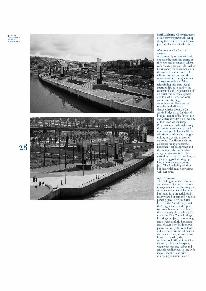
Muelles de Marzana y La MercedUna estrecha franja de la orilla izquierda, frente al centrohistórico de la villa y al mercado donde antiguamente sedescargaba bacalao, cacao, grano y sal para consumo de lapoblación cuya tipología arquitectónica expresa todavíaesta función y que mantenían su configuración de callecon calzada de tránsito. En su rehabilitación ha primadoel concepto de regeneración social de un barrio muydegradado por diversas circunstancias socio-urbanísticas.Se trata de dos tramos de diferentes características, desdeel puente de San Antón hasta el de la Merced, por suantiguo uso y diversa anchura a un lado y otro de lapasarela de la Ribera, vinculados peatonalmente como unacontinuidad con una urbanización realizada con diferentecriterio, fue inaugurada en , con una longitud de m y una superficie de m. El primer tramo estáresuelto con un acertado carácter de espacialidadhorizontal con el imprescindible mobiliario de concepciónminimalista. El segundo, en un lugar muy angosto, es unsendero en voladizo a modo de embarcadero de estructurametálica con revestimiento de madera. Atrevida solucióncuya duda es su buen mantenimiento con el paso deltiempo.
Ripa-UribitarteLa supresión del paso del tren eliminando suinfraestructura en permitió acceder a unos muellesque hacía muchos años no se usaban para actividadesportuarias pero si para aparcamiento público. Es unespacio entre el Puente del Arenal y el Guggenheim,constituido por dos tramos en diferente alineación unidosen el paso bajo el puente del Ayuntamiento, en unproyecto unitario, de m de longitud con unasuperficie de . m sensiblemente horizontal resueltoen dos niveles con escasa diferencia para absorber eldesfase con el frente urbano edificado preexistente.Proyectado por el Gabinete de Arquitectura delAyuntamiento es un espacio amplio, visualmente diáfanorealizado con sobriedad y sensatez, sin concesiones a lafrivolidad acorde a su identidad portuaria y coninteresantes aportaciones de mobiliario urbano específicode nueva creación. Construido entre y , poruna franja intermedia entre paseo y calzada, circula untranvía desde .
AbandoibarraSe trata del frente de una amplia operación urbanísticaque acapara, por su espectacularidad, la atención. Es laconjunción de dos sectores diferentes. Uno, el bordefluvial del Guggenheim vinculado como unaprolongación espacial del edificio mediante un estanque
Botika Zaharra. Water treatmentcollectors were previously set upalong these banks to avoid directpouring of waste into the ría.
Marzana and La MercedwharvesA narrow strip on the left bank,opposite the historical centre ofthe town and the market wherecod, cocoa, grain and salt used tobe unloaded for consumption inthe town. Its architecture stillreflects this function and thestreet retains its configuration asa busy thoroughfare. Whenrefurbishing this area, specialattention has been paid to theconcept of social regeneration ofa district that is very degradeddue to a whole series of socialand urban planningcircumstances. There are twostretches with differentcharacteristics, from the SanAntón bridge up to La Mercedbridge, because of its former useand different width on either sideof the Riverside walkway.Pedestrians can walk right alongthis continuous stretch, whichwas developed following differentcriteria, opened in , is m long and covers an area of, m. The first stretch wasdeveloped using a successfulhorizontal spatial approach andthe indispensable minimalistdesign urban furniture. Thesecond, in a very narrow place, isa projecting path making up akind of metal wood-coveredjetty. This is a daring solution,but one which may not weatherwell over time.
Ripa-Uribitarte The pulling up of the train lineand removal of its infrastructurein made it possible to get tocertain wharves which had notbeen used for port activities formany years, but rather for publicparking space. This is an areabetween the Arenal bridge andthe Guggenheim, made up oftwo stretches in different lines,that come together as they passunder the City Council bridge,in a single project, , m longand covering a fairly horizontalarea of , m, built on twoplanes on nearly the same level inorder to even out the differenceswith the existing built-up urbanfront. Designed by theArchitectural Office of the CityCouncil, this is a wide space,visually uncluttered, sober andsensible, unfrivolous, in line withits port identity, and withinteresting contributions of
Vistas deAbandoibarraViews ofAbandoibarra

sobre el que transcurre como borde una pasarelacurvilínea paralela al cauce. Secuencial y formalmente essemejante por su austeridad al colindante paseo deUribitarte. Sin grandes contrastes excepto la nuevabarandilla de acero inoxidable que es una acertadainterpretación del antiguo modelo tradicional defundición y sin concesiones banales al adorno urbano.El otro tramo a continuación, aguas abajo, inicia elllamado Parque de Ribera, en realidad un parterreadosado al paseo que se extiende entre las dos pasarelas-senderos, paralelos a la ría, sobre los respectivosestanques de borde: desde el del Guggenheim hasta eldel Euskalduna. Es el resultado de un Concurso deIdeas, abierto resuelto a principios de , convocadopor la sociedad de capital público Bilbao Ría-,responsable de la gestión de toda esta área. Ha sidoinaugurado en marzo de . Consiste en un trazadode m levemente curvilíneo y convexo respecto a laría y de anchura creciente desde los m de su centro,bajo el puente de Deusto, hasta los m de losextremos con una superficie total de . m resueltoen tres niveles. El de paseo del muelle, con anchura uniforme, peroescasa, continuación secuencial del frente delGuggenheim y de similar tratamiento; otro paralelosuperior excepto en los extremos en que confluyen almismo nivel tratado con adoquines rojos; y un jardín entalud de ancho variable, conectados entre sí por rampasy escaleras. Esta complejidad, en parte, es debida a lapresencia de la pasarela que atraviesa la ría a un nivelexcesivamente elevado y requiere complejas circulacionesde acceso. En esta franja se ha formalizado el denomina-do “paseo de la memoria” constituido por la implanta-ción, a intervalos, de diversas esculturas de reconocidosartistas vascos y otros internacionales, que con diferentesestilos y fortuna, le otorgan un indudable interés. En losextremos del jardín se sitúan dos espacios de formatriangular y carácter más público. Uno, cerca delGuggenheim como zona de juegos infantiles aisladomediante arbolado, y el otro, con dos planos inclinadosde hierba que convergen hacia una marquesina-escena-rio triangular a modo de recinto para posibles actuacio-nes al aire libre.En conjunto adquiere un pronunciado protagonismo laverticalidad de las exageradas linternas de acero corteny cristal de m de altura y unas extrañas, por laclimatología y la identidad arbórea de la ciudad,abundantes plantaciones de palmeras: algosorprendentemente inquietante. La parte final del paseo,en el borde, interrumpiendo su continuidad yuniformidad se transforma a modo de pantalán en unasuperficie de madera de bolondo de m de longitud y de anchura. Predomina como argumento un exceso deformalismo de aparatoso diseño para funciones tan
elementales como iluminar un paseo y el conjuntoadquiere el aspecto de los parques temáticos.La capacidad transformadora del área de Abandoibarratenía unas inmensas posibilidades por sus favorablescondiciones previas: por un lado el borde de unhomogéneo Ensanche, limitado parcialmente por unparque realizado en , recreación del bosque urbano,de . m; por el otro, la ría. Su centro atravesadopor el puente de Deusto, construido en , de enormeelegancia ordenando el conjunto, ha sido alterado,acaparado como elemento central dinamizador de lacomposición de un absurdo y agobiante centrocomercial. El resultado, ya perceptible, ha pervertido unaextraordinaria zona ansiada socialmente como un espaciode oportunidad, en todos los sentidos, urbanístico,paisajístico, y cultural, y se ha convertido en lainoportunidad de una de las más mercenarias ymiserables operaciones inmobiliarias que se puedaconcebir en una ciudad democrática europea.El parque, que tradicionalmente había sido el elementode mediación entre la ciudad y la industria junto a la ría,exigía, sin duda alguna, su ampliación hasta el borde dela lámina fluvial convirtiéndose en una gran plaza haciael agua. Esta es una habitual disposición en ciudades conrío y muy tradicional en las villas vascas con un espaciode parque o alameda junto a su núcleo urbano con unadotación para esparcimiento casi siempre presidida yamenizada por un kiosco: Portugalete, Plentzia, Bermeo,Lekeitio, Ondarroa, Deba, Zumaia, Orio, Errenteria... Así, además estaba ya previsto en el Avance del PlanGeneral de Ordenación Urbana de Bilbao aprobado en, cuando se muestra esta lógica vinculación. Todocambió radicalmente al realizarse la propuesta másconvincente de la Consulta Internacional de Ordenaciónde Abandoibarra resuelta en queincompresiblemente ignoraba estas cualidades ycondiciones del lugar.Es por tanto, rotundamente rechazable estamanipulación al ser interrumpida su lógica expansión yquedar cerrado como un espacio residual, apropiándosedel parque convertido en un gran jardín interior de unaagrupación de manzanas de una promocióninmobiliaria. Ha perdido radicalmente su indudablecualidad de espacialidad y apertura de visuales. Lo queen principio podía haber sido el encuentro entre doscomponentes de la naturaleza, el parque y el agua, se hatransformado en un incidente lamentable entre lageografía y la especulación, cuyas nefastas consecuenciasurbanas son, además de repudiables y palpables,irreversibles.La reciente inauguración, en noviembre de , delMuseo Marítimo de la Ría de Bilbao, ha permitidoprolongar, aguas abajo, más espacios públicos de riberacon la incorporación de las infraestructuras industriales
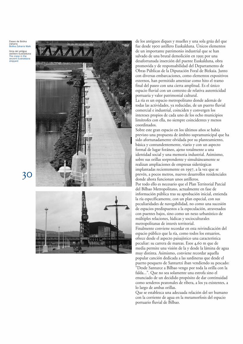
de los antiguos diques y muelles y una sola grúa del quefue desde astillero Euskalduna. Únicos elementosde un importante patrimonio industrial que se hansalvado de una brutal demolición en por unadesafortunada inserción del puente Euskalduna, obrapromovida y de responsabilidad del Departamento deObras Públicas de la Diputación Foral de Bizkaia. Juntocon diversas embarcaciones, como elementos expositivosexternos, han permitido amenizar como hito el tramofinal del paseo con una cierta amplitud. Es el únicoespacio fluvial con un contexto de relativa autenticidadportuaria y valor patrimonial cultural.La ría es un espacio metropolitano donde además detodas las actividades, ya reducidas, de un puerto fluvialcomercial e industrial, coinciden y convergen losintereses propios de cada uno de los ocho municipioslimítrofes con ella, no siempre coincidentes y menoscoordinados. Sobre este gran espacio en los últimos años se habíaprevisto una propuesta de ámbito supramunicipal que hasido afortunadamente olvidada por su planteamiento,básica y contundentemente, viario y con un aspectoformal de lugar foráneo, ajeno totalmente a unaidentidad social y una memoria industrial. Asimismo,sobre sus orillas sorprendente y simultáneamente serealizan ampliaciones de empresas siderúrgicasimplantadas recientemente en , a la vez que seprevén, a pocos metros, nuevos desarrollos residencialesdonde ahora funcionan unos astilleros.Por todo ello es necesario que el Plan Territorial Parcialdel Bilbao Metropolitano, actualmente en fase deinformación pública tras su aprobación inicial, entiendala ría específicamente, con un plan especial, con suspeculiaridades de navegabilidad, no como una sucesiónde espacios predispuestos a la especulación, atravesadoscon puentes bajos, sino como un nexo urbanístico demúltiples relaciones, lúdicas y socioculturalesmetropolitanas de interés territorial.Finalmente conviene recordar en esta reivindicación delespacio público que la ría, como todos los estuarios,ofrece desde el aspecto paisajístico una característicapeculiar: su carrera de mareas. Esos , m que demedia permite una visión de la y desde la lámina de aguamuy distinta. Asimismo, conviene recordar aquellapopular canción dedicada a las sardineras que desde elpuerto pesquero de Santurtzi iban vendiendo su pescado:“Desde Santurce a Bilbao vengo por toda la orilla con lafalda...”. Que no sea solamente una estrofa sino elenunciado de un decidido propósito de dar continuidadcomo senderos peatonales de ribera, a los ya existentes, alo largo de ambas orillas. Que se establezca una adecuada relación del ser humanocon la corriente de agua en la metamorfosis del espacioportuario fluvial de Bilbao.
Paseo de BotikaZaharraBotika Zaharra Walk
Grúa del antiguoastillero EuskaldunaThe crane in theancient Euskaldunashipyard

newly created specific urbanfurniture. It was built between and . A tram has runalong the strip between thewalkway and the road since .
AbandoibarraThis is the front of a wide-rangingurban operation, which draws thewatcher’s attention because of itsspectacularity. It is the joining oftwo different sectors. One, theriverside of the Guggenheim,linked as the spatial extension ofthe building using a pond overwhich there passes a curvedwalkway parallel to the river’sflow. Both sequentially andformally it is similar in itsausterity to the neighbouringUribitarte walkway. There are nogreat contrasts, except the newstainless steel railings, which are asuccessful interpretation of theold traditional model of cast iron,and no banal concessions made tourban adornment.The other stretch that continuesdownstream begins the so-calledParque de Ribera, or RiversidePark, which is in fact anornamental garden attached to thewalkway, and stretches betweenthe two walkways-paths parallel tothe ría on the respective ponds oneach side: from the Guggenheimpond to the Euskalduna pond.This is the result of aCompetition for Ideas, opened inearly , organised by thepublic-financed company BilbaoRía-, in charge of themanagement of this whole area. Itwas opened in March . Itcomprises a stretch of m,slightly curved and convex withrespect to the ría and with awidth that increases from m inthe centre, under the Deustobridge, up to m at the ends,with a total area of , m,resolved on three levels. Then there is the wharf walkway,with a continuous narrow width,the sequential continuation of thefront of the Guggenheim andtreated in a similar way; anotherparallel upper walkway, the end ofwhich joins the other at the samelevel which is finished with redcobblestones, and a slopinggarden of varying width, allconnected between each otherusing ramps and steps. Thiscomplexity is due in part to thepresence of the walkway thatcrosses the ría at too high a leveland requires complex manoeuvresto access it. It is along this stripthat the so-called “walk downmemory lane” has been built. Itfeatures different sculptures by
recognised Basque andinternational artists, spread out atintervals, which make it a veryinteresting site because of itsdifferent styles. At both ends ofthe garden are two triangular areasof a more public nature. One ofthese, close to the Guggenheim isa children’s play area closed offwith trees, and the other, withtwo sloping grass lawns thatconverge towards a bandstand – atriangular stage that acts as a kindof enclosure for possible open-airevents. On the whole, one inescapablefeature is the verticality of the extravagant m high steel andglass street lamps and someabundant palm tree plantations,which are most strange in thelight of the city’s climate and tree-lined identity, and are surprisinglydisturbing. The end of thewalkway, interrupting itscontinuity and uniformity on theriver edge, turns into a kind ofjetty in an area of Missanda wood m long and m wide. Thereis an excessive formalism in theflamboyant design for functionsso elemental as lighting a walkwayand the whole takes on theappearance of a theme park.The transforming capacity of theAbandoibarra area offeredimmense possibilities thanks to itsfavourable starting conditions.On the one hand, its location onthe edge of a homogeneous cityextension area, partly limited by apark built in , which is therecreation of the urban forest,covering , m. On theother, the ría. Its centre, crossedby the incredibly elegant Deusto bridge, which ordered theensemble, has been altered,captured as the centraldynamising element of thecomposition by an absurd andtiring Commercial Centre. Theresult, which was alreadyperceptible, has perverted anextraordinary area, so covetedsocially as an area of opportunity,in all senses: urban, landscape,and cultural. It has become theinappropriateness of one of themost mercenary and miserablereal estate operations imaginablein a democratic European city.The park, traditionally theelement of mediation betweencity and industry along with thería, certainly demanded to beextended up to the edge of theriver strip, turning into a greatsquare facing the water. This is ausual layout in river cities, andvery traditional in the Basquetowns with a park space or tree-
lined avenue next to its towncentre with a recreation areaalmost always presided over andlivened up with a newspaperstand: Portugalete, Plentzia,Bermeo, Lekeitio, Ondarroa,Deba, Zumaia, Orio, Errenteria...In fact, it had already beendecided in the Preview of theGeneral Urban Spatial Plan ofBilbao, approved in , whenthis logical link was seen.Everything changed radicallywhen the most convincingproposal was made at theInternational Consultation onSpatial Planning of Abandoibarraheld in , which for someunknown reason ignored thesequalities and conditions of theplace.This manipulation is therefore tobe rejected outright, as itinterrupted its logical expansionand closed it off as a residual area,appropriating the park which hadbeen turned into a great innergarden of a group of blocks in areal estate project. It has radicallylost its unquestionably special andfar-seeing quality. What could inprinciple have been a meetingbetween two components ofnature – park and water – hasbeen turned into a shamefulincident, between geography andspeculation, the disastrous urbanconsequences of which are notonly condemnable and palpable,but irreversible. The recent opening, in November, of the Maritime Museum ofthe ría of Bilbao, has made itpossible to extend more publicriverside areas downstream withthe incorporation of the industrialinfrastructures of the old seawallsand wharves and a single cranefrom what up until was theEuskalduna shipyard. These areunique elements of a considerableindustrial heritage which weresaved from brutal demolition in by the unfortunate insertionof the Euskalduna bridge, aproject promoted by, and also theresponsibility of the Departmentof Public Works of the BizkaiaProvincial Government. Alongwith different vessels, like externalelements of an exhibition, theyhave made it possible to liven upthe final stretch of the walkway bywidening it somewhat. It is theonly river area with a context ofrelative port authenticity andvalue as cultural heritage.The ría is a metropolitan space inwhich, in addition to the alreadyreduced activities of a commercialand industrial river port, there is acoincidence and convergence of
the own interests of each of theeight neighbouringmunicipalities, which do notalways coincide, nor are they co-ordinated. On this great spaceover the last few years there hadbeen a supramunicipal proposalwhich fortunately was forgottendue to its basic road-basedapproach and a formal appearancethat was totally divorced from anylocal social identity and industrialmemory. Also on its banks, asurprising coincidence of eventswas taking place: steel companiesset up in were expanding,whilst, a few metres further on,new residential developments areplanned where shipyards are stillworking.For all of these reasons it is fornecessary the Partial TerritorialPlan of Metropolitan Bilbao,which is currently in publicinformation phase after its initialapproval, to understand the ríaspecifically, with a special plan,with its particular shipping needs,not as a succession of areas opento speculation, crossed by lowbridges, but as an urban linkinvolving multiple metropolitanleisure and socio-cultural relationsof territorial interest.Finally it should be rememberedas we make this claim for a publicspace, that the ría, like allestuaries, offers as a uniquefeature from the landscape pointof view: its racing tides. One canget a very different view of thestrip of water over these . mon average. Likewise, we shouldnot forget a popular songdedicated to the sardine sellerswho brought their wares from thefishing port of Santurtzi to sell:“From Santurce to Bilbao I comeright along the shore with myskirts...” This should not just be achorus but the statement of adecided objective consisting ofproviding continuity to theexisting riverside walkways alongboth banks. People must establishan appropriate relationship withthe water current in themetamorphosis of the river portarea of Bilbao.