meigs county subdivision regulations€¦ · mcrpc – subdivision regulations 2-3 improvements,...
TRANSCRIPT
SUBDIVISION REGULATIONS
Meigs County, Tennessee
Prepared For The
Meigs County Regional Planning Commission
APRIL 1994
(Amended through October, 2007) (Amended through October 2011)
(Amended through December 2012)
i
TABLE OF CONTENTS
ARTICLE PAGE SUBDIVISION PROCESS TITLE ............................................................................................. 1 1 Short Title, Preamble, Enactment Clause ...................................... 1-1 2 Definition of Certain Terms Used Herein ....................................... 2-1 3 Platting Jurisdiction, Enforcement and Penalties for Violation ............................................................. 3-1 3.01 Platting Authority ...................................................... 3-1 3.02 Use of Plat ............................................................... 3-1 3.03 Enforcement ............................................................. 3-1 3.04 Opening and Improving Public Roads ...................... 3-1 3.05 Erection of Buildings ................................................ 3-1 3.06 Penalties .................................................................. 3-2 4 General Design Requirements ...................................................... 4-1 4.01 Suitability of the Land ............................................... 4-1 4.02 Name of Subdivision ................................................ 4-1 4.03 Access ..................................................................... 4-1 4.04 Public Use Areas ..................................................... 4-1 4.05 Large-Scale Development ........................................ 4-2 5 General Design Requirements for Roads and other Rights-of-Way ....................................................................... 5-1
5.01 Conformance to Adopted Major Thoroughfare Plan ................................................... 5-1 5.02 Continuation of Existing Roads ................................ 5-1 5.03 Road Connections ................................................... 5-1 5.04 Road Elevations ....................................................... 5-1 5.05 Road Names ............................................................ 5-1 5.06 Restriction of Access................................................ 5-1 5.07 Alleys ....................................................................... 5-1 5.08 Private Roads .......................................................... 5-2 5.09 Requirements for Private Roads .............................. 5-3 5.10 Reserve Strips ......................................................... 5-5 5.11 Easements ............................................................... 5-5 5.12 Road Grading Plan Required ................................... 5-5 6 Specific Design Requirements for Roads and other Rights-of Ways ..................................................................... 6-1 6.01 Road Right-of-Way Widths ....................................... 6-1 6.02 Additional Width on Existing Roads ......................... 6-2
ii
6.03 Road Pavement Widths ........................................... 6-2 6.04 Road Grades ............................................................ 6-3 6.05 Horizontal Curves .................................................... 6-3 6.06 Vertical Curves ......................................................... 6-3 6.07 Intersections ............................................................. 6-6 6.08 Tangents .................................................................. 6-6 6.09 Road Jogs ................................................................ 6-6 7 Design Standards for Blocks and Lots ........................................... 7-1 7.01 Block Lengths and Widths ........................................ 7-1 7.02 Flood-Free Building Site ........................................... 7-1 7.03 Lot Sizes .................................................................. 7-1 7.04 Lot Lines .................................................................. 7-2 7.05 Building Setback Lines ............................................. 7-2 7.06 Lots Abutting Public Roads ...................................... 7-2 7.07 Double and Reverse Frontage Lots ......................... 7-2 7.08 Flat Lots ................................................................... 7-2 8 Procedure for Preliminary Plat Approval of a Subdivision .................................................................................... 8-1 8.01 Pre-Application Review ............................................ 8-1 8.02 Application for Preliminary Plat Approval ................. 8-1 8.03 Review of Preliminary Plat ....................................... 8-2 8.04 Certificate of Tentative Approval .............................. 8-2 9 Preliminary Plat Specifications for Subdivisions ............................ 9-1 9.01 Scale ........................................................................ 9-1 9.02 Sheet Size ................................................................ 9-1 9.03 Ground Elevations ................................................... 9-1 9.04 Information to be Provided on Preliminary Plat ........................................................................... 9-1 10 Required Site Improvements Before Final Plat Approval ........................................................................................ 10-1 10.01 Monuments .............................................................. 10-1 10.02 Grading .................................................................... 10-1 10.03 Installation of Utilities ............................................... 10-3 10.04 Required Inspections During Road Construction ............................................................. 10-3 10.05 Street or Road Base................................................. 10-3 10.06 Surface Course ........................................................ 10-3 10.07 Storm Drainage ........................................................ 10-4 10.08 Water Supply System............................................... 10-5 10.09 Sanitary Sewers ....................................................... 10-5 10.10 Sidewalks ................................................................. 10-5 10.11 Curbs and Gutters, or Road Shoulders .................... 10-6 10.12 Road Signs .............................................................. 10-6

iii
10.13 Guarantee in Lieu of Completed Improvements .......................................................... 10-6 10.14 Road Acceptance ..................................................... 10-6 11 Procedure for Final Plat Approval of a Subdivision .................................................................................... 11-1 11.01 Application for Final Plat Approval ........................... 11-1 11.02 Review of Final Plat ................................................. 11-1
11.03 Procedure for Expeditious Certification of a Minor Subdivision ............................................................... 11-1
11.04 Requirements for Subdivisions in Previously Approved Subdivisions ........................... 11-2
11.05 Recording of Final Plat ............................................. 11-3 12 Final Plat Specifications ................................................................ 12-1 12.01 Final Plat Specifications ........................................... 12-1 12.02 Certifications Required ............................................. 12-3 13 Variances and Amendments ......................................................... 13-1 13.01 Variances ................................................................. 13-1 13.02 Amendments ............................................................ 13-1 14 Legal Status Provisions ................................................................. 14-1 14.01 Separability .............................................................. 14-1 14.02 Conflict with other Regulations ................................. 14-1 14.03 Adoption and Effective Date ..................................... 14-1 Appendix Suggested Steps for a Developer of a Subdivision When Preliminary Approval Has Been Granted Questions Often Asked About Subdivision Regulations Preliminary Subdivision Plat Checklist Final Subdivision Plat Checklist

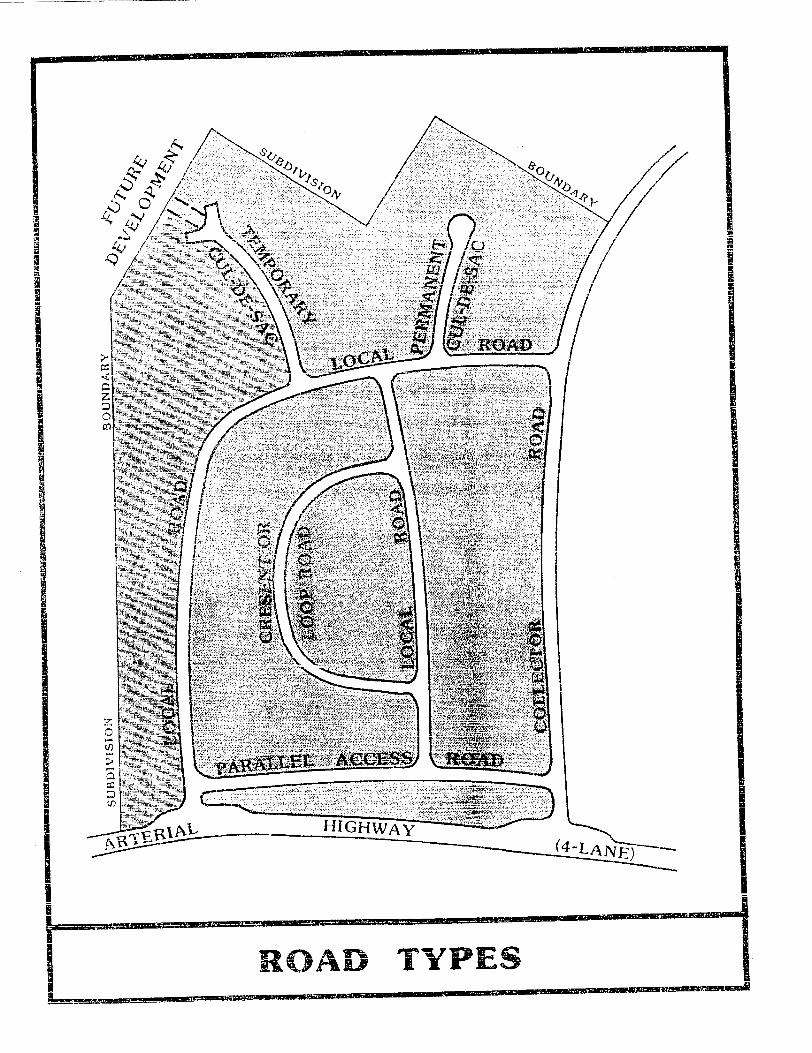
LIST OF ILLUSTRATIONS TITLE PAGE SUBDIVISION PROCESS 100-YEAR FLOOD PLAIN SCHEMATIC ............................................................ 2-4 ROAD TYPES ..................................................................................................... 2-8 WHAT IS A SUBDIVISION ? .............................................................................. 2-11 SETBACKS AND YARDS ................................................................................... 2-12 SLOPE CALCULATION ...................................................................................... 6-5 STREET JOGS/INTERSECTIONS ..................................................................... 6-7 HORIZONTAL CURVE/STREET PROFILE ........................................................ 6-8 TYPES OF LOTS ................................................................................................ 7-4 SUBDIVISION DESIGNS .................................................................................... 8-3 PRELIMINARY PLAT .......................................................................................... 9-3 CUT AND FILL CROSS SECTION ..................................................................... 10-2 TYPICAL TANGENT SECTION TYPE 1 ............................................................. 10-8 TYPICAL TANGENT SECTION TYPE 2 ............................................................. 10-9 FINAL PLAT ........................................................................................................ 12-2


MCRPC – Subdivision Regulations 1-1
MEIGS COUNTY SUBDIVISION REGULATIONS
TITLE
REGULATIONS CONTROLLING THE SUBDIVISION OF LAND IN MEIGS COUNTY, TENNESSEE: REQUIRING AND REGULATING THE PREPARATION AND PRESENTATION OF PRELIMINARY AND FINAL DESIGN STANDARDS; REQUIRING MINIMUM IMPROVEMENTS TO BE MADE OR GUARANTEED TO BE MADE BY THE SUBDIVIDER; SETTING FORTH THE PROCEDURE TO BE FOLLOWED BY THE PLANNING COMMISSION IN APPLYING THESE RULES, REGULATIONS AND STANDARDS: AND PRESCRIBING PENALTIES FOR THE VIOLATION OF ITS PROVISIONS.
ARTICLE 1
SHORT TITLE, PREAMBLE AND ENACTMENT CLAUSE
THIS DOCUMENT SHALL BE KNOWN AND MAY BE CITED AS THE "SUBDIVISION REGULATIONS OF MEIGS COUNTY." IN PURSUANCE OF AUTHORITY SET FORTH IN SECTION 13-3-401 THROUGH 13-3-411, TENNESSEE CODE ANNOTATED, AND FOR THE PURPOSES OF PROMOTING THE HEALTH, SAFETY, MORALS, CONVENIENCE, ORDER, PROSPERITY AND GENERAL WELFARE OF THE COUNTY; TO ENCOURAGE ECONOMICALLY SOUND AND STABLE LAND DEVELOPMENT; TO ASSURE THE PROVISION OF REQUIRED STREETS, UTILITIES AND OTHER FACILITIES AND SERVICES TO LAND DEVELOPMENTS; TO ASSURE THE ADEQUATE PROVISION OF SAFE AND CONVENIENT TRAFFIC ACCESS AND CIRCULATION, BOTH VEHICULAR AND PEDESTRIAN, IN LAND DEVELOPMENT; TO ASSURE THE PROVISION OF NEEDED PUBLIC OPEN SPACES AND BUILDING SITES IN LAND DEVELOPMENTS THROUGH THE DEDICATION OR RESERVATION OF LAND FOR RECREATIONAL, EDUCATIONAL AND OTHER PUBLIC PURPOSES; AND TO ASSURE THAT LAND IS DEVELOPED IN CONFORMITY WITH THE COMPREHENSIVE PLAN OF MEIGS COUNTY, THE PLANNING COMMISSION OF MEIGS COUNTY, TENNESSEE DOES ORDAIN AND ENACT THE FOLLOWING ARTICLES AND SECTIONS.

MCRPC – Subdivision Regulations 2-1
ARTICLE 2
DEFINITION OF CERTAIN TERMS USED HEREIN
Except as specifically defined herein, all words used in these regulations have their customary dictionary definitions where not inconsistent with the context. For the purposes of these regulations certain words or terms are defined as follows: The term "shall" is mandatory. when not inconsistent with the context, words used in the singular number include the plural and those used in the plural number include the singular. Words used in the present tense include the future. Bond. Any form of security (including a cash bond, surety bond, undated letter-of-credit, cashiers check, or certified check) in an amount and form satisfactory to the planning commission for the amount of the estimated construction cost guaranteeing the completion of physical improvements according to plans and specifications within the time prescribed by the subdivider's agreement with the MCRPC. Community Wastewater Treatment System. (Added 10/20/2011) A type of decentralized wastewater treatment system or “On-Site Sewage Facility (OSSF).” However, unlike an individual septic system, in which effluent from a septic tank is absorbed into the soil by means of an absorption field, a community wastewater treatment system routes effluent to a dispersal field, which may be a drip field or a spray field. The installation and maintenance of such a facility in Meigs County shall be regulated and permitted by the Tennessee Department of Environment and Conservation (TDEC) and the Tennessee Regulatory Authority (TRA). Deed Restrictions. A private covenant among the residents of a subdivision or development limiting uses or setting conditions within the subdivision or development. Developer. Any individual, subdivider, firm, association, syndicate, partnership, corporation, trust, or any other legal entity commencing proceedings under these regulations to effect a subdivision of land hereunder for himself or for another (see "Subdivider"). Easement. The right given by a property owner to another party (either public or private) for a specific limited use of a designated part of his property.
Easement, Drainage. A perpetual, unobstructed easement across property reserved to carry surface water drainage along specified routes to natural water courses. Drainage easements shall not be filled or built upon in any way that will impede the flow of surface water. Easement, Utility. An easement for the installation, operation, inspection, maintenance, repair, or replacement of public utility lines, cables, poles, ditches, pipes, manholes, etc. and the appurtenances belonging thereto.

MCRPC – Subdivision Regulations 2-2
Easement, Vehicular. The right granted by the owner of land to another party by deed or prescription, to allow vehicular access across one parcel of land to another.
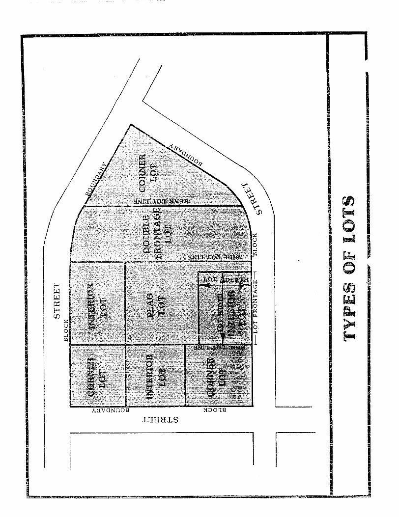
Flag Lot. An interior lot located to the rear of another lot but with a narrow portion of the lot extending to the road. The narrow portion of the lot that extends to the road shall be suitable for ingress and egress, and shall not be included in the calculation of the minimum lot area. Flood. A temporary rise or overflow of a body of water onto adjacent lands not normally covered by water. Other FLOOD-RELATED TERMS are defined as follows:
Channel. A natural or artificial watercourse with definite bed and banks to confine and conduct continuously or periodically flowing water. The top of the banks form the dividing lines between the channel and the floodplain.
Floodplain. The relatively flat area or lowlands adjoining a watercourse or other body of water which has been or may be covered by water.
Floodway. The channel of the watercourse and those portions of the adjoining flood plain which are reasonably required to provide for the passage of flow from the regulatory flood (the 100-year Flood). This area must be left unobstructed in order to preserve the flood-carrying capacity of the stream and its flood plain without appreciably increasing the height of the floodwaters.
Floodway Fringe. That part of the flood plain located between the floodway and the designated outline of the 100-year Flood which would be covered by flood waters of the 100-year Flood. Uses are permitted if they are protected by fill, flood-proofed, or otherwise protected.
Regulatory Flood. A large flood selected for regulatory purposes and a basis for floodplain management. In Meigs County, as in most places, the 100-year Flood is the regulatory flood or base flood and there are no flood restrictions outside its limit. The 100-year Flood statistically has a one-percent chance of occurring each year.
Grade (slope). The slope of a road, or the ground, specified by the percentage that the horizontal distance is to the vertical rise which occurs within the horizontal distance. Health Authority. The director of the county or district health department having jurisdiction over the county health, or his duly authorized representative, usually a county environmentalist who works for the Tennessee Department of Health and Environment.

MCRPC – Subdivision Regulations 2-3
Improvements, Subdivision. Road pavement or resurfacing, curbs, gutters, sidewalks, water lines, sewer lines, storm drains, street lights, flood control and drainage facilities, utility lines, landscaping, and other related facilities normally associated with the development of raw land into building sites and which may be required by subdivision regulations. Lot. A portion or parcel of land separated from other portions or parcels by description as on a subdivision plat or record of survey map or as described by metes and bounds, and intended for transfer of ownership or for building development. For the purpose of these regulations, the term does not include any portion of a dedicated right-of-way. Lot, Non-residential. A lot intended to be used for purposes other than residential structures and their accessory uses; such as for commercial or industrial development. Lot of Record. A designated tract of land as shown on a plat or other document recorded in the County Register's Office or the County Assessor of Property's Office.


MCRPC – Subdivision Regulations 2-5
LOT DIMENSIONS are defined as follows:
Lot Area. The total area of a lot calculated from surveyed boundaries or other
reliable means. The lot area of a flag lot shall not include its access strip.
Lot Width. The width of the lot measured along a straight line between side lot
lines (generally parallel to the road) and measured at the building setback line as
indicated on the plat.
Lot Depth. The average distance from the front lot line measured
perpendicularly to the rear lot line.
MCRPC-PLANNING COMMISSION. Meigs County Regional Planning Commission Mobile Home-Manufactured Home. A factory-manufactured structure or housing unit at least eight feet in width and 40 feet in length, which is not self-propelled, but which is built as a single unit and is transportable. It is built on a permanent single chassis and is designed to be used with or without a permanent foundation when connected to the required utilities. It does not include recreational vehicles or travel trailers. Monuments. Permanent concrete or iron markers used to establish definitely all lines on the plat of a subdivision, including all lot corners, boundary lines, corners, and points of change in road alignment. Offer of Dedication. The act of granting land or roads to an entity, such as the government, association, person, etc. The offer of dedication shall not constitute the acceptance of such land or roads by the local government, association or person. Owner. Any person, group of persons, firm or firms, corporation or corporations, or any other legal entity having legal title to or sufficient proprietary interest in the land sought to be subdivided under these regulations. Planning Region. The land within the Meigs County Planning Region. More specifically, all land in Meigs County which is outside of incorporated municipalities and their planning regions, if any. Planning Staff. The planner assigned to Meigs County from the Tennessee Department of Economic and Community Development, Local Planning Office. Plat. The scale drawing or map of a subdivision including plat, plan, plot, or replot.
Preliminary Plat. A subdivision plat showing the proposed lot arrangement and with the provisions contained in Article 9. It is generally submitted to the MCRPC for approval prior to the preparation of the final plat.

MCRPC – Subdivision Regulations 2-6
Final Plat. A subdivision plat prepared in accordance with the provisions contained in Article 12. The final plat is designed to be placed on record with the County Register after approval by the planning commission.
Public Wastewater Collection and Treatment Plant. (Added 10/20/2011) A facility, also known as a sewer treatment plant, where wastewater comprised of storm water runoff and / or household sewage is treated. The wastewater is transferred to the facility through a network of gravity and / or force mains. The treatment process involves a variety of physical, chemical, and biological processes to remove physical, chemical and biological contaminants. Ultimately, the facility’s objective is to procuce an environmentally-safe effluent suitable for disposal. The installation and maintenance of such a facility shall be regulated and permitted by the Tennessee Department of Environment and Conservation (TDEC) and the Tennessee Regulatory Authority (TRA). Regional Flood (or its equivalent). A flood used in the most recent flood study comparable to the largest floods known to have occurred on streams of similar physical characteristics in the same geographic region. Resubdivision. A change in a map of an approved or recorded subdivision plat if such change affects any road layout on such map, or area reserved thereon for public use, or any lot line; or if it affects any map or plan legally recorded prior to the adoption of any regulations controlling subdivisions. Right-Of-Way (R.O.W). A strip of land occupied or intended to be occupied by a road, crosswalk, railroad, road, electric transmission line, oil or gas pipeline, water main, sanitary or storm sewer main, or for another special use. The usage of the term "right-of-way" for land platting purposes shall mean that every right-of-way hereafter established and shown on a final plat is to be separate and distinct from the lots or parcels adjoining such right-of-way and not included within the dimensions or areas of such lots or parcels. Right-of-way intended for roads, crosswalks, water mains, sanitary sewers, storm sewers, storm drains, or any other use involving maintenance by a public agency shall be dedicated to public use by the maker of the plat on which such right-of-way is established. Such rights-of-way shall not become a governmental responsibility until accepted, however. Road. Any right-of-way designed for vehicular movement. "Road" includes the full width of the right-of-way between property lines as well as the traveled portion thereof. "Road" includes "street", "highway", or any other designation of a right-of-way designed for vehicular movement. For the purpose of these regulations, ROADS are divided into the following categories:
a. Interstate - the road designated as such in the Transportation Plan of Meigs County
b. Major and Minor Arterials - the roads designated as such in the
Transportation Plan of Meigs County.

MCRPC – Subdivision Regulations 2-7
c. Collectors - a road which primarily carries traffic from local roads to
arterials. Collector roads include those designated as such in the Transportation Plan of Meigs County.
d. Local Road - a neighborhood road used primarily for access to the
abutting properties. e. Marginal Access Road - a minor road parallel and adjacent to major
thoroughfares which offers access to abutting properties and is used to limit access points on an arterial.
f. Alley - a minor way used for service access to the back or side of
properties otherwise abutting on a road. g. Cul-de-sac - a local road with only one outlet, sometimes called a
"dead-end" road. A cul-de-sac is measured from its dead-end or vehicular turn around back to the first intersection.
h. Private Road - a privately-maintained road constructed on a
recorded permanent easement and built to the standards set forth in these regulations.

MCRPC – Subdivision Regulations 2-9
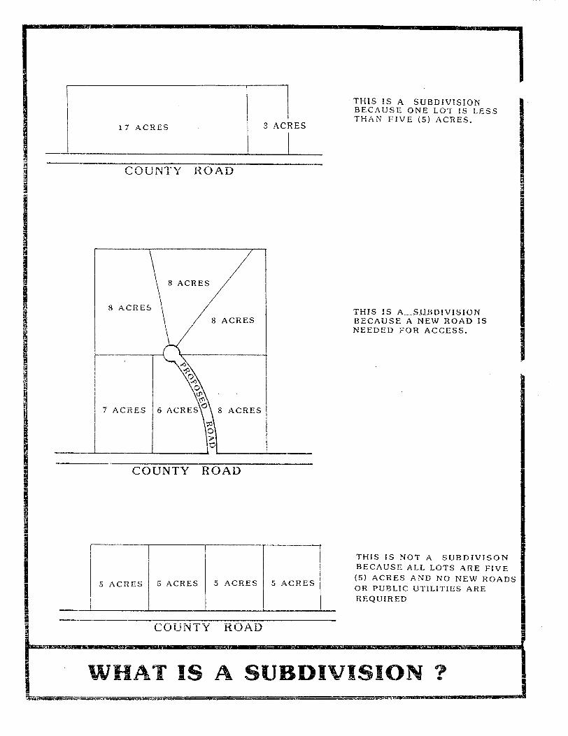
Roadway. The actual road surface which is utilized to transport motor vehicles including necessary road shoulders and drainage facilities including ditches, curbing and guttering. Road Paving Material Class. "Class" refers to the type and cleanliness of the paving material. Road Paving Material Grade. "Grade" refers to the size of the aggregate in the paving material. Sanitary Sewer System. A municipal or community sewage collection, treatment, and disposal system of a type approved by the Department of Health and Environment. Setback Line. A line established by the Subdivision Regulations, generally parallel with and measured from the lot lines, delineating the minimum allowable distance between the property line and a building on a lot within which no building or other structure shall be placed except as otherwise provided. Subdivider. The person, firm or corporation having such a proprietary interest in the land to be subdivided as will authorize the maintenance or proceedings to subdivide such land under this ordinance, or the authorized agent, person, firm or corporation for the purpose or proceeding under these regulations. Subdivision. The term "subdivision" means the division of a tract or parcel of land into two or more lots, sites, or other divisions for the purpose whether immediate or future, of sale or building development and includes resubdivision; and the definitions of such subdivision shall be restricted to the following:
a. All such divisions where one (1) or more of the resulting tracts is less than five (5) acres in size;
b. All such divisions where a new road or public utility installation
(water or sewer) is required, regardless of the size of any or all of the parcels.
The following are EXCLUDED from the definition of a "subdivision:" a. Testamentary division of property; b. Partnership division of property between two or more owners of an
undivided interest by court order or by deeds; c. Divisions where the resulting tracts are all over five (5) acres, all
have frontage on an existing publicly-maintained road, and where none require the extension of public water or sewer lines.
Subdivision Regulations. The "Meigs County, Tennessee, Subdivision Regulations" in its entirety and future amendments, thereto.

MCRPC – Subdivision Regulations 2-10
Variance. A variance is a modification of the strict terms of the relevant regulations where such modification will not be contrary to the public interest and where, owing to conditions peculiar to the property and not the result of the action of the applicant, a literal enforcement of the regulations would result in unnecessary and undue hardship.

MCRPC – Subdivision Regulations 2-13
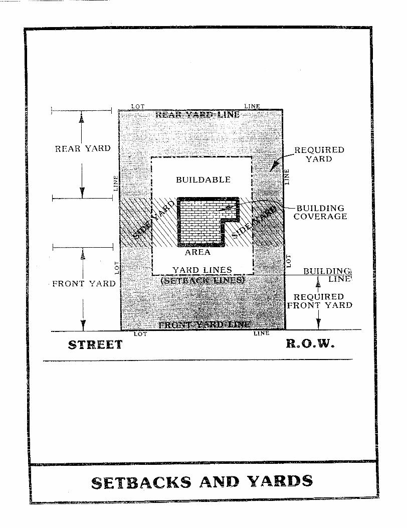
Yard, Front. The required open space, unoccupied by buildings, between the road or street right-of-way line and the principal building. Yard, Rear. The required space, unoccupied except by an allowed accessory use, extending from the rear of the principal building to the rear lot line the full width of the lot. Yard, Side. The space, unoccupied except as herein provided, measured between side lot line and the nearest point of the principal building and between the front yard and the rear yard.

MCRPC – Subdivision Regulations 3-1
ARTICLE 3
PLATTING JURISDICTION, ENFORCEMENT AND PENALTIES FOR VIOLATION
The enforcement of these regulations and penalties for the unapproved recording or transfer of land are provided by state law in the authority granted by public acts of the State of Tennessee. Section 3.01. Platting Authority. From and after the passage of these regulations, the Planning Commission shall be the official platting authority, and no plat of a land subdivision shall be entitled to record in the office of the Meigs County Register unless it shall have the approval of the Planning Commission inscribed thereon. The filing or recording of a plat of a subdivision without the approval of the Planning Commission, as required by these regulations, is declared to be a misdemeanor, punishable by law, with each day of noncompliance being a separate offense. Section 3.02. Use of Plat. The transfer of, sale of, agreement to sell, or negotiation to sell land by reference to or exhibition of, or other use of a subdivision plat that has not been given final approval by the Planning Commission and recorded in the office of the Meigs County Register is prohibited, and the description by metes and bounds in the instrument of transfer or other document shall not exempt the transaction from such penalties. Section 3.03. Enforcement. No plat or plan of a subdivision located within the area of planning jurisdiction shall be admitted to the land records of the county or received or recorded by the County Register of Deeds until said plat or plan has received final approval in writing by the Secretary of the Planning Commission as provided in Section 13-3-402, Tennessee Code Annotated. Section 3.04. Opening and Improving Public Roads. No public officer, authority or county governing body shall accept, layout, open, improve, grade, pave or light any road, lay or authorize the laying of water mains or sewers, or the construction of other facilities or utilities in any road located within the area of planning jurisdiction unless such road shall have been accepted, opened, or otherwise received the legal status of a public road prior to the adoption of these regulations, or unless such road corresponds in its location and lines to a road shown on a subdivision plat approved by the Planning Commission, or on a road plan made and adopted by the Commission as provided in Section 13-3-406, Tennessee Code Annotated. Section 3.05. Erection of Buildings. No building permit shall be issued and no building shall be erected on any lot in a subdivision within the area of jurisdiction of the Regional Planning Commission unless the road giving access thereto has been accepted as a public road in accordance with these regulations, or unless such road has been accepted as a public road prior to the effective date of these regulations. Any building or structure erected or to be erected in violation of this section shall be deemed an unlawful building or structure, and the building commissioner or
MCRPC – Subdivision Regulations 3-2
the county attorney or other official designated by the Meigs County Commission may bring action to enjoin such erection or cause it to be vacated or removed. Section 3.06. Penalties. (Amended 9/12/06) No county register shall receive, file, or record a plat of a subdivision within the planning region without the approval of the Planning Commission as required in Section 13-3-402, Tennessee Code Annotated. Tennessee Code Annotated, Section 13-3-410, provides that whoever being the owner or agent of the owner of any land, transfers or sells or agrees to sell or negotiates to sell such land by reference to or exhibition of or by other use of a plat of subdivision of such land without having submitted a plat of such subdivision to the Planning Commission and obtained its approval as required before such plat be recorded in the office of the appropriate county register, and the description of metes and bounds in the instrument of transfer or other document used in the process of selling or transferring shall not exempt the transaction. The county, through its county attorney or other official designated by its chief legislative body, may enjoin such transfer or sale or agreement by action or injunction.
MCRPC – Subdivision Regulations 4-1
ARTICLE 4
GENERAL DESIGN REQUIREMENTS Section 4.01. Suitability of the Land. The Planning Commission shall not approve the subdivision of land if, from adequate investigations conducted by all public agencies concerned, it has been determined that in the best interest of the public the site is not suitable for platting and development purposes of the kind proposed. Land within any designated floodway as shown on the Meigs County Flood Insurance Rate Map (FIRM), shall not be platted for residential occupancy or building sites. Fill may not be used to raise land within any designated floodway. In other areas subject to flood, fill may be used providing the proposed fill does not restrict the flow of water and unduly increase flood heights. Section 4.02. Name of Subdivision. The name of the subdivision must have the approval of the Planning Commission. The name shall not duplicate or closely approximate the name of an existing subdivision unless such subdivision is a resubdivision according to Section 11.04 of these regulations. Section 4.03. Access. Access to every subdivision shall be provided over a county-maintained road. Access may also be provided over a private road according to Section 5.08 and Section 5.09 of these regulations. Section 4.04. Public Use Areas. When features of other plans adopted by the Planning Commission, (such as schools or other public building sites, parks or other land for public uses) are located in whole or in part in a land subdivision, land for such features shall be either dedicated or reserved by the subdivider for acquisition within one (1) year by the appropriate public agency. Whenever a plat proposes the dedication of land to public uses that the Planning Commission finds not required or suitable for such use, the Planning Commission shall refuse to approve the plat, and shall notify the governing body of the reasons for such action. Note: One of the primary purposes and advantages of planning for the dedication and reservation of property for public use is to indicate areas which may be presently acquired at acreage prices rather than at greatly increased prices in the future, where future improvements would increase the expense to the taxpayer and create inconvenience for the individual property owner and for the neighborhood. Where public use is to be made of the property and where the residents of the subdivision will receive primary benefit, the dedication of the property should be encouraged. Where the public use is for the public as a whole, the community should pay proportionately for the acquisition of reserved areas within a reasonable time. A reasonable time is to be determined according to the circumstances, because the subdivider should not be required to hold his land idle for a lengthy indefinite period.

MCRPC – Subdivision Regulations 4-2
Section 4.05. Large-Scale Development. The requirements of these regulations may be modified in the case of large scale community or neighborhood units, such as housing project, mobile home park or shopping center which is not subdivided into customary lots, blocks and roads. Plans for all such developments shall be presented to the Planning Commission for review and approval prior to the commencement of construction. The requirements and regulations of the "Manufactured Homes and Recreational Vehicles" chapter of the Tennessee Code Annotated, Sections 68-36-101 through 68-36-411, and those of the Meigs County Regulations governing commercial mobile home parks and travel trailer parks, must be satisfied and the approval of the local health authority must be secured prior to approval by the Planning Commission.

MCRPC – Subdivision Regulations 5-1
ARTICLE 5
GENERAL REQUIREMENTS FOR ROADS AND OTHER RIGHTS-OF-WAY
Section 5.01. Conformance to Adopted Transportation Plan. All roads and other features of the Transportation Plan of Meigs County, Tennessee, shall be platted by the subdivider in the location and to the dimensions indicated on the Transportation Plan adopted by the Planning Commission. Section 5.02. Continuation of Existing Roads. Existing roads shall be continued at the same or greater width, but in no case less than the required width. Section 5.03. Road Connections. Where proposed roads are to adjoin existing roads, the developer must make the connection at his expense and meet all road design requirements set forth in these regulations. Section 5.04. Road Elevations. The Planning Commission may require, where necessary, profiles and elevations of roads in areas subject to flood, as defined in these regulations. Fill may be used for roads provided such fill does not unduly increase flood heights. Drainage openings shall be so designed as to not restrict the flow of water and unduly increase flood heights, the minimum size of pipe or tile shall be fifteen (15) inches. (Amended 12/10/02) Section 5.05. Road Names. The road names shall require the approval of the Planning Commission. Roads that are obviously in alignment with roads already existing and named shall be given the name of the existing road. Lot numbers shall be assigned to all parcels and shown on the final plat. Lots on the left side of the road while traveling north or west shall have odd numbers. Lots on the left side of the road while traveling south or east shall have even numbers. Roads that are obviously in alignment with roads already existing shall continue the existing numbering system. Before assigning any road or lot a number, the developer shall first contact the E-911 Director of Meigs County in order to locate the correct road number. Section 5.06. Restriction of Access. When a tract fronts on an arterial or highway, the Planning Commission may require such lots to be provided with frontage on a marginal access road or may require reverse frontage lots. Section 5.07. Alleys. Alleys may be required at the rear of all lots used for multi-family, commercial or industrial developments but shall not be provided in one-and-two family residential developments unless the subdivider provides evidence satisfactory to the Planning Commission of the need for alleys.

MCRPC – Subdivision Regulations 5-2
Section 5.08. Private Roads. (Amended 10-10-00) Permanent easements and private roads under this Resolution are defined as any non-exclusive permanent easement for vehicular access which: 1) serves one lot which does not front on a publicly maintained road and which will contain one, and only one residence, or 2) serving two or more owners or renters for the benefit the those being served by it. A permanent easement utilized by more than one lot or private road shall be owned by (a) the property owner(s) utilizing the easement/road or (b) a property owners association. Said permanent easement or private road may be vacated or closed only by all parties in interest, unless said easement/road is dedicated to public use by the owner(s) and accepted by the Meigs County Commission for maintenance. Private easements/roads serving two or more owners, renters or lots, shall meet the following standards:
a. The subdivision plat and individual deeds shall be noted that the permanent easement/private road is a “private road” and not maintained by Meigs County.
b. An additional certification shall be noted on the final subdivision plat
defining the ownership of said permanent easement/private road. c. The permanent easement/private road shall be open to emergency,
public safety.
d. The permanent easement/private road may not connect two (2) or more public roads.
e. The permanent easement/private road shall meet the specifications
set forth in Section 5.09 below. f. When two lots abut end of a permanent easement/private road as
shown in the drawing below, the private road shall extend into those two lots the same distance as the required width of the private road easement to provide a more adequate road frontage

MCRPC – Subdivision Regulations 5-3
g. All of the requirements for a permanent easement/private road
established by this resolution shall be completed prior to final approval of the subdivision plat by the Meigs County Regional Planning Commission.
Section 5.09. Requirements for Private Roads. (Amended 10-10-00) All permanent easements/private roads shall meet the following standards:
a. Easement/road width and length:
1) Single lot permanent easement not to exceed five hundred feet (500') in length unless granted a variance by the planning commission, a minimum of twenty-five feet (25') in width.
2) For a subdivision which has a permanent easement/private
road with six (6) or fewer lots, 1,000 feet or less in length, a 40-foot minimum easement or road right-of-way.
3) For subdivisions of seven lots or more, the pavement shall
be a minimum of twenty (20) feet with 2 foot gravel shoulders; provided that where the planning commission requires a 60 foot right-of-way, the pavement width shall be 26 feet with two foot shoulders. All private roads that provide access to a subdivision of seven lots or more shall meet this requirement. Any such private road(s) shall also

MCRPC – Subdivision Regulations 5-4
meet the requirements for roads in Article 6 and Article 10 of this resolution (Amended December 11, 2012).
4) For subdivisions with a permanent easement/private road
with seven (7) or more lots, a 50-foot right-of-way; provided that where 100 lots or more are served, the Meigs County Regional Planning Commission may require a 60-foot right-of-way.
b. Road pavement widths:
1) Single-lot permanent easement: no requirement 2) For subdivisions of six (6) lots or less, the road surface shall
be a minimum of two (2) inches of compacted crusher run gravel, sixteen (16) feet wide.
3) For subdivisions of seven lots or more, the pavement shall
be a minimum of twenty (20) feet with 2 foot gravel shoulders; provided that where the planning commission requires a 60 foot right-of-way, the pavement width shall be 26 feet with two foot shoulders.
c. Storm drainage. An adequate drainage system including
necessary open ditches, pipes, culverts, intersection drains, drop inlets, bridges, etc., shall be provided for the proper drainage of all surface water. A professional engineer or land surveyor shall determine the size of the culvert. Cross drains should be provided to accommodate all natural water flow and shall be of sufficient length to permit a full width roadway and the required slopes. The U.S. Soil and Water Conservation Service shall determine the size and location of cross drains, but in no case shall they be less than fifteen (15) inches in diameter. All storm drainage contained in pipes or culverts under the roadway shall have endwalls, headwalls, or riprap with a concrete apron wall where necessary to prevent erosion.
NOTE: Pipes shall be laid with the spigot end pointing in the direction of the flow and with the ends fitted and matched to provide tight joints and a smooth uniform invert. They shall be placed at a sufficient depth below the roadbed to avoid dangerous pressure of impact, and in no case shall the top of the pipe be less than one (1) foot below the roadbed.
d. Curbs and Gutters, or Road Shoulders. Within Meigs County, the
permanent easement/private road shall have concrete or asphalt curbs and gutters, or two (2) foot gravel shoulders on each side of the paved surface, of a type as shown in the Meigs County Subdivision Regulations, as amended.

MCRPC – Subdivision Regulations 5-5
e. Road Signs. 1) Street name blades shall be of 24 inch, 30 inch or
42 inch x 6 inch extruded aluminum, posted with “X” type or 90° brackets on 2" galvanized pipes, 10½' long, set 3 feet into the ground in a concrete base at the intersection of all roads within the subdivision and at the point existing roads are intersected by the roads of the subdivision. The blade shall be covered with brown 3M-engineer grade reflective sheeting with 4" standard capital letters in silver, 3M-engineer grade reflective sheeting, or approved equal.
2) All traffic control devices shall conform to the applicable
provisions of the current edition of the U.S. DOT, Federal Highway Administration Manual on Uniform Traffic Control Devices.
f. Width, pavements, and other specific design requirements shall
conform to the standards shown in Articles 6 and 10 of the Meigs County Subdivision Regulations.
Section 5.10. Reserve Strips. There shall be no reserve strips controlling access to roads, except where the control of such strips is definitely placed with the county under conditions approved by the planning commission. Section 5.11. Easements. Easements having a minimum width of ten (10) feet shall be provided where deemed necessary along each side or rear lot line for utility lines and underground mains and cables. Easements of the same or necessary greater width shall be required along the lines of, or across lots, where necessary for the extension of existing or planned utilities. Where a subdivision is traversed by a water course, drainage way, channel or stream, there shall be provided a storm-water or drainage right-of-way of adequate width. Parallel roads may be required by the Planning Commission in connection therewith. Section 5.12. Road Grading Plan Required. (Added 10-10-00) Every new road in a subdivision with five or more lots, or which shall in the future have five or more lots, and which is to be dedicated to the county for maintenance, shall have a grading plan bearing the stamp of a registered professional engineer licensed to practice in the State of Tennessee. Said plan shall accompany the preliminary plat of a subdivision.

MCRPC – Subdivision Regulations 6-1
ARTICLE 6
SPECIFIC DESIGN REQUIREMENTS FOR ROADS AND OTHER RIGHTS-OF-WAY
Section 6.01. Road Right-of-Way Widths. The right-of-way width shall be the distance across a road from property line to property line. Minimum road right-of-way widths shall be as follows:
a. Major Arterials ...................................................................... 140 feet (See Transportation Plan) or as may be required b. Minor Arterials ........................................................................ 80 feet (See Transportation Plan) c. Primary Collectors .................................................................. 60 feet (See Transportation Plan)
Secondary or collector roads are those which carry traffic from minor roads to the major system of arterial roads and highways and include the principal entrance roads of a residential development and roads for major circulation within such a development;
d. Minor Roads ........................................................................... 50 feet e. Marginal Access Roads .......................................................... 50 feet
Marginal access roads are minor roads which are parallel to and adjacent to arterial roads and highways; and which provides access to abutting properties and protection from through traffic;
f. Alleys ...................................................................................... 20 feet
Alleys are minor public ways used primarily for service access to the back or side of properties otherwise abutting on a road.
g. Cul-de-sacs ............................................................................ 50 feet
(Amended 10/9/07) Cul-de-sacs are permanent dead-end roads or courts designed so that they cannot be extended in the future. Except where topographic or other conditions make a greater length unavoidable, cul-de-sacs, or dead-end roads, shall not be greater in length than 2,500 feet. They shall be provided at the closed end with a turn-around having a

MCRPC – Subdivision Regulations 6-2
property line radius of at least fifty (50) feet with an outside pavement radius of at least forty (40) feet.
h. Temporary Cul-de-sacs .......................................................... 50 feet
Where, in the opinion of the Planning Commission, it is desirable to provide for road access to adjoining property, proposed roads shall be extended by dedication to the boundary of such property. Such dead-end roads shall be provided with a temporary turn-around having a property line radius of at least fifty (50) feet with an outside pavement radius of at least forty (40) feet. Where deemed necessary by the Planning Commission adequate rights-of-way shall be dedicated to connect with any temporary dead-end roads adjoining the subdivision.
Section 6.02. Additional Width on Existing Roads. Subdivisions that adjoin existing roads shall dedicate additional right-of-way to meet the minimum road width requirements.
a. The entire right of way shall be dedicated where any part of the subdivision is on both sides of the existing road, and
b. Where the subdivision is located on only one side of an existing
road, the amount of right-of-way to be dedicated is as follows:
1. If the land across the roadway from the proposed subdivision has not been subdivided or developed, the subdivider is only required to dedicate one-half of the required right-of-way, measured from the center line of the existing roadway.
2. If the land across the roadway has been subdivided or
developed, the subdivider is required to provide enough additional right-of-way on his side of the roadway to bring the total right-of-way to the required width. (In no case shall the right-of-way be less than fifty (50) feet.)
c. In cases where rights-of-way in excess of fifty (50)
feet are required, additional widths shall be reserved and when used just compensation therefore shall be paid by the condemning authority.
Section 6.03. Road Pavement Widths. Road pavement widths shall be as follows:
a. Major Arterials ......................................................... 30 feet or greater, or as may be required
b. Minor Arterials ......................................................... 30 feet or greater, or as may be required

MCRPC – Subdivision Regulations 6-3
c. Primary Collectors ................................................... 30 feet or greater, or as may be required
d. Secondary Collectors ............................................................. 30 feet e. Minor (Neighborhood) .............................................. 20 feet (with 2 foot gravel shoulders on each side of paved road)
f. Alleys ...................................................................................... 16 feet g. Cul-de-sacs ............................................................................ 40 foot radius or turnaround. h. Through proposed neighborhood or local business areas the
road widths shall be increased ten (10) feet on each side to provide for turning movements of vehicles into and out of necessary off-road parking areas without interference to traffic.
NOTE: The pavement widths are measured from inside of curb to
inside of curb. These widths are considered the minimum necessary to accommodate modern traffic. All Arterials and Collectors are designed to be high-volume, high-speed traffic movers. At no time should parking be allowed along Arterials or Collectors; however in the case of Local Roads, road parking must be considered in the pavement width. Where no road parking is permitted or none is anticipated, allowances may be made. A parallel parking lane normally requires eight (8) feet.
Section 6.04. Road Grades. Maximum and minimum road grades shall be fourteen (14) percent and five-tenths of one percent (0.5) respectively. NOTE: These road grade limits are considered to be the optimum requirements to provide adequate safety. Different topographical situations may necessitate adjustment. The minimum grade requirement is necessary for drainage purposes. In this regard, it should be considered that in addition to accommodating traffic, roads are the heart of the surface drainage system. Section 6.05. Horizontal Curves. Where a deflection angle of more than ten (10) degrees in the alignment of a road occurs, the road shall have a centerline radius of not less than the following:
a. Arterials ................................................................................ 300 feet b. Collectors ............................................................................. 200 feet c. Minor Roads ......................................................................... 100 feet
Section 6.06. Vertical Curves. Every change in grade shall be connected by a vertical curve constructed so as to afford a minimum sight distance of two

MCRPC – Subdivision Regulations 6-4
hundred (200) feet, said sight distance being measured from the driver's eyes, which are assumed to be three and one-half (3 1/2) feet above the pavement, to an object six (6) inches high on the pavement. Where, in the opinion of the Planning Commission, topography warrants it profiles of all roads showing natural and finished grades drawn to a scale of not less than one (1) inch equals one hundred (100) feet horizontally and one (1) inch equals twenty (20) feet vertically may be required.


MCRPC – Subdivision Regulations 6-6
Section 6.07. Intersections. Road intersections shall be as nearly at right angles as is possible, and no intersection shall be at an angle of less than sixty (60) degrees. Curb radii at road intersections shall not be less than twenty (20) feet, and where the angle of a road intersection is less than seventy-five (75) degrees, the Planning Commission may require a greater curb radius. Wherever necessary to permit the construction of a curb having a desirable radius without curtailing the sidewalk at a road corner to less than normal width, the property line at such road corner shall be rounded or otherwise setback sufficiently to permit such construction. Section 6.08. Tangents. Between reverse curves there shall be a tangent having a length not less than one hundred (100) feet. Section 6.09. Road Jogs. Road Jogs with centerline off-sets of less than one hundred fifty (150) feet shall not be allowed.


MCRPC – Subdivision Regulations 7-1
ARTICLE 7
DESIGN STANDARDS FOR BLOCKS AND LOTS
Section 7.01. Block Lengths and Widths. Block lengths and widths shall be as follows:
a. Blocks shall be no greater than one thousand two hundred (1,200) feet nor less than three hundred (300) feet in length, except in unusual circumstances; and
b. Blocks shall be wide enough to provide two (2) tiers of lots of
minimum depth, except where abutting upon major roads or where other situations make this requirement impracticable.
Section 7.02. Flood-Free Building Site. Each lot in a subdivision shall contain a flood-free building site outside of the limits of any existing easement or the building setback lines as required by these regulations. The finished floor elevation for a concrete slab on grade type of structure or the bottom of the floor joist for a crawl space type of structure shall have a minimum elevation above the elevation for a flood of 100-year frequency. The authority for establishing the 100-year frequency of occurrence flood elevation shall be the Tennessee Valley Authority's Flood Control Branch or the Corps of Engineers, Department of the Army. In the event the site is not in an area covered by one of these agencies or for which a study has not been done, a comprehensive study will be required by a professional engineer licensed to practice in Tennessee. Section 7.03. Lot Sizes. Residential lots shall meet the lot width and lot area requirements of the Zoning Resolution. In the absence of a Zoning Resolution, residential lots shall not be less than fifty (50) feet wide at the setback (building) line. Other lot size requirements follows:
a. Residential lots shall have a depth of not less than one hundred (100) feet and not greater than three (3) times the width of the lot at the building line, unless unusual circumstances make these limitations impractical.
b. Lots not served by public water and sanitary sewer systems shall
be at least twenty-five thousand (25,000) square feet in area or of a size specified by the County health Officer to adequately accommodate both a fresh-water well and septic tank on the same lot. Where individual septic tanks are used and public water provided, minimum lot size shall be twenty thousand (20,000) square feet. The Health Officer shall also prescribe minimum lot sizes to conform to health standards, which may be greater than the standards contained herein.
c. Residential corner lots shall have adequate width to meet building
setback requirements for both abutting roads. d. Commercial and industrial lots shall be adequate in size to provide
service areas and off-road parking suitable for the type of use and development contemplated. Platting of individual lots should be

MCRPC – Subdivision Regulations 7-2
avoided in favor of an overall design of the land to be used for such purposes.
e. Land shall not be platted for commercial or industrial purposes
unless the subdivider can demonstrate to the Planning Commission that each lot provides the following: 1. A site that does not unduly interfere with through traffic.
(Each industrial subdivision or area shall utilize a single collector for all heavy traffic between the area and the general system of roads. Minor industrial roads and individual industrial parcels shall be oriented at right angles with the collector and with adjacent railroads.)
2. An integrated parking area. 3. An insulation against any adverse effect on any present or
future adjacent residences. 4. A parcel size sufficient in area to allow future expansion.
Section 7.04. Lot Lines. All lot lines shall be perpendicular or radial to road lines, unless impractical because of topographic or other features. Section 7.05. Building Setback Lines. A building line (setback line) meeting the front yard setback requirements of the Zoning Resolution shall be established on all lots. In the absence of a Zoning Resolution, the front yard setback shall be a minimum of thirty-five (35) feet from the road right-of-way lines. Other minimum setback lines shall be as follows:
a. From the side property line ..................................................... 10 feet
b. From rear property line ........................................................... 15 feet
c. From side property line ........................................................... 35 feet which abuts a minor road (corner lots) or greater
Section 7.06. Lots Abutting Public Roads. Each lot shall abut upon a dedicated public road or private easement/road meeting Meigs County Private Road Standards, as amended. (Amended 12/10/02) Section 7.07. Double and Reverse Frontage Lots. Double frontage and reverse frontage lots shall be avoided, except where essential to provide separate residential development from traffic arteries or to overcome specific disadvantages of topography and orientation. Reverse frontage lots shall have a depth of not less than one hundred and fifty (150) feet. A planted evergreen screen easement of at least ten (10) feet wide, across which there shall be no right of access, shall be provided along the line of lots abutting a traffic artery or other incompatible use. Section 7.08. Flag Lots. A “Flag Lot” is a lot which, except for a narrow private access lane, does not front on or abut a publicly-maintained street or road. These lots are to provide a building site in the interior or a tract of land behind lots which have full frontage on a publicly maintained street or road.
a. Within the portion of the flag lot which excludes the access strip,
the building setbacks for front, side and rear yards shall still apply and be measured from the boundaries of the parcel excluding the access strip.
MCRPC – Subdivision Regulations 7-3
b. No more than two access strips shall be located side-by-side. c. Flag stems shall not exceed six hundred (600) feet. d. Width:
1. For flag lots of two (2) acres or less, the access strip shall be not less than twenty-five (25) feet in width.
2. For flag lots of more than two (2) acres, but not more than
five (5) acres, the access strip shall be not less then forty(40) feet in width.
3. For flag lots of over five (5) acres, the access strip shall be a
minimum of fifty (50) feet in width.

MCRPC – Subdivision Regulations 8-1
ARTICLE 8
PROCEDURE FOR PRELIMINARY PLAT APPROVAL OF A SUBDIVISION
Section 8.01. Pre-Application Review. Whenever a subdivision of a tract of land within Meigs County is proposed, the subdivider is urged to consult early and informally with the Secretary or a designated member of the Planning Commission. The subdivider may submit sketch plans and data showing existing conditions within the site and in its vicinity and the proposed layout and development of the subdivision. No fee shall be charged for the pre-application review and no formal application shall be required. NOTE: (1) The purpose of the pre-application review is to afford the subdivider
an opportunity to avail himself of the advice and assistance of the Planning Commission in order to facilitate the subsequent preparation and approval of plans.
At this stage, the subdivider should also consult with any lending
institution that will be participating in the financing of his proposed development and with the Federal Housing Administration of the Department of Housing and Urban Development that may be insuring mortgages on houses that may be built in this land subdivision.
(2) The various plat reviews required by these regulations may properly
be made by the Secretary or a designated member of the Planning Commission. It would be wasteful of time for the entire Planning Commission membership to review a proposed land subdivision, except in cases of conflict or unusual and difficult problems. Approval or disapproval in every case must be by action of the Commission. This note applies only to reviews.
Section 8.02. Application for Preliminary Plat Approval. Following the pre-application review of a proposed subdivision, the subdivider shall submit to the Chairman of the Planning Commission, at least fifteen (15) days prior to the next regular meeting of the Planning Commission for agenda inclusion, the following:
a. A letter requesting review and approval of a preliminary plat and giving the name and address of a person to whom the notice of the hearing by the Planning Commission on the preliminary plat shall be sent, and
b. Six (6) copies of the preliminary plat and other documents,
as specified in Article 9. NOTE: Six (6) copies of the preliminary plat and other documents are
suggested to provide a review and record copy for: 1. Planning Commission; 2. Subdivider; 3. Public Utility Department or Company (for record); 4. County Health Officer; 5. County Engineer; and 6. The County Road Superintendent.

MCRPC – Subdivision Regulations 8-2
Section 8.03. Review of Preliminary Plat. The Planning Commission shall check the plat for conformance to these regulations and shall afford a hearing on the preliminary plat. Thereafter, the Planning Commission shall give tentative approval or disapproval of the preliminary plat. A notation of the action shall be made in the minutes of the meeting. Two (2) copies of a list containing the reasons for disapproval, if the preliminary plat is disapproved, shall be issued. One (1) copy shall be returned to the subdivider or his agent and one (1) copy added to the records of the Planning Commission. Tentative approval of a preliminary plat does not constitute approval of a final plat. It indicates only approval of the layout as a guide to the preparation of the final plat. Tentative approval shall expire and be null and void after a period of one (1) year unless an extension of time is applied for by the subdivider or his representative and approved by the Planning Commission. If action on a preliminary plat is not taken by the Planning Commission within sixty (60) days of the date of submittal, the preliminary plat shall be considered approved and a certificate of approval shall be issued on demand. However, the applicant for approval may waive this requirement and consent to an extension of time. Section 8.04. Certificate of Tentative Approval. Two (2) Certificates of Tentative Approval of the Preliminary Plat by the Planning Commission shall be issued. One (1) copy for the subdivider or his agent and one (1) for the Planning Commission records. The certificate shall contain the following:
"Pursuant to the Subdivision Regulations of Meigs County, all the requirements of tentative approval have been fulfilled. Therefore, this "Preliminary Plat" has been approved by the Meigs County Planning Commission on _________________, 19____. This approval does not constitute approval of a Final Plat. This Certificate of Tentative Approval shall expire and be null and void on (date)_____________________" _______________ ____________________________________ Date Secretary, Meigs County Regional Planning Commission
NOTE: After the subdivider has received preliminary plat approval, he may begin work on the necessary improvements for final plat approval or may post a surety bond in the amount needed to install the required improvements.


MCRPC – Subdivision Regulations 9-1
ARTICLE 9
PRELIMINARY PLAT SPECIFICATIONS FOR SUBDIVISIONS
Section 9.01. Scale. The preliminary plat shall be clearly and legibly drawn at a scale not smaller than one hundred (100) feet to one (1) inch or at a scale satisfactory to the planning commission. Section 9.02. Sheet Size. Sheet size shall be one of the following sizes: 11 x 17 inches, 18 x 24 inches, 24 x 36 inches. If the complete plat cannot be shown on one (1) sheet of this size, it may be shown on more than one (1) sheet with an index map on a separate sheet of the same size. (Amended 12/10/02) Section 9.03. Ground Elevations. Contours shall be shown at vertical intervals of not more than five (5) feet except when specifically not required by the Planning Commission. The method for obtaining the contour lines shall be stated on the preliminary plat. Contours shall not be required on the final plat. Section 9.04. Information to be Provided on Preliminary Plat. (Amended 10-10-00) The preliminary plat shall contain the following information:
a. Name of subdivision; b. Name, address and phone number of owner of record,
subdivider (if different), and surveyor; c. North point, date of drawing, graphic scale and date; d. Vicinity map showing location and acreage of subdivision; e. Exact boundary lines of the tract by bearing and distances; f. Names of adjoining property owners and/or subdivisions; g. Existing roads, buildings, water courses, railroads, culverts,
utilities and easements on and adjacent to the tract; h. Proposed design including all roads and alleys with
proposed road names, lot lines with approximate dimension, easements, land to be reserved or dedicated for public uses and any land to be used for purposes other than single family dwellings;
i. Block numbers and lot numbers; j. Plans of proposed utility layouts (sewer, water, gas, and
electricity) showing feasible connections to the existing or any proposed utility systems and drainage. When connections to certain public utilities are not practical, any

MCRPC – Subdivision Regulations 9-2
proposed individual water supply and/or sewage disposal system must be approved by the county health department;
k. Minimum building front yard setback lines as provided in
Section 7.05 of these regulations. l. The present zoning classification, if any, on the land to be
subdivided and on the adjoining land; m. Road cross-section. n. Centerline profile when required by the planning
commission. o. A road grading plan, if required, as provided in sec. 5.12. o. If any portion of the land being subdivided is subject to flood,
as defined in these regulations, the limit of such flood shall be shown.

MCRPC – Subdivision Regulations 10-1
ARTICLE 10
REQUIRED SITE IMPROVEMENTS BEFORE FINAL PLAT APPROVAL
Prior to the approval of a final plat, an agreement shall be reached between the subdivider or his agent and the county government with regard to the installation of any road improvements or utility construction called for in the subdivision. The subdivider shall be required to have installed at his expense the following improvements.: NOTE: The subdivider at his expense, may contract with the county or a private firm to install the necessary improvements. Section 10.01. Monuments. (Amended 12-10-02)
a. All corners shall be established, and shall be metal, concrete, or a natural object. The type of corner (old or new) shall be indicated on the plat. A notation shall be made stating whether the corners were found or set and in addition, the statement shall indicate the material and size of the corner found or set.
b. Metal corners shall be no less than ½ inch in diameter; concrete
corners shall be no less than 4-inches in diameter; and both shall be no less than 18 inches in length unless some impregnable material is encountered.
c. All new corners place shall have a cap or tag of non-corrosive
material with surveyor's registration number or company name stamped. In the case of placement of concrete marker, the marker shall have a permanent mark for the survey point in addition to said cap or tag.
Ref. Section 0820-3-.07(1)(h) Rules of Tenn. State Board of
Examiners for Land Surveyors)
Section 10.02. Grading. All roads, streets and alleys shall be graded by the subdivider to the required cross section. Due to special topographical conditions, deviation from the above will be allowed only with special approval of the Planning Commission. Where roads are constructed under or adjacent to existing electric transmission lines, the nearest edge of the roadway surface shall be a minimum of fifteen (15) feet from any transmission line structure and all grading for the road shall be done in a manner which will not disturb the structure or result in erosion endangering the structure. In the case of electric transmission lines, the clearance from the road to the nearest conductor shall meet the requirements of the National Electrical Safety Code.
a. Preparation. Before grading is started the entire right-of-way area shall be first cleared of all stumps, roots, brush and


MCRPC – Subdivision Regulations 10-3
other objectionable materials and all trees not intended for
preservation. b. Cuts. All tree stumps, boulders and other obstructions shall
be removed to a depth of two (2) feet below the subgrade. Rock, when encountered, shall be sacrificed to a depth of
twelve (12) inches below the subgrade. This provision
applies to the roadway and not necessarily to the entire right-of-way width.
c. Fill. All suitable material from roadway cuts may be used in
the construction of fills, approaches or at other places as needed. Excess materials, including organic materials, soft clays etc., shall be removed from the development site. The fill shall be spread in layers not to exceed twelve (12) inches loose and compacted by a sheep's foot roller. The filling of utility trenches and other places not accessible to a roller shall be mechanically tamped.
Section 10.03. Installation of Utilities. After grading is completed and approved and before any base is applied, all of the required underground work -- water mains, sewer lines, gas mains, etc., and all service connections shall be installed completely and approved throughout the subdivision. If utility improvements are needed at any time after the roadway has been constructed, said improvements shall be installed under the roadway so as to not require disturbing (cutting) the existing constructed roadway. Section 10.04. Required Inspections During Road Construction. Before road construction begins the developer shall contact the Meigs County Road Superintendent as notification and to discuss pre-construction project specifics. While road construction is taking place, inspections shall be made by the Road Superintendent before, during and after each step or process and prior to the next course or procedure. The road superintendent shall check the width, depth and crown of the road among other things. Weight tickets showing the type, class, and weight of gravel and surfacing material shall be furnished to the road superintendent after the completion of each step. Section 10.05. Street or Road Base. (Amended 1/13/04) When Hot Mix is applied at the rate of 220 pounds per square yard, or two (2) inches, Mineral Aggregate 303-02 shall be compacted to a minimum of six (6) inches. When the base is completed, the developer must notify the Meigs County Road Superintendent and allow his office time to inspect the base before proceeding to the installation of the surface course. Section 10.06. Surface Course. If the proposed subdivision takes its access from an existing county road, which has a hot mix surface, then the subdivision roads shall have an asphaltic concrete (hot mix) surface course as further specified. If the proposed subdivision takes its access from an existing county road, which is not surfaced with hot mix, then the subdivision roads may be

MCRPC – Subdivision Regulations 10-4
constructed with either a hot mix surface or with a double bituminous surface as further specified.
a. The Asphaltic Concrete Surface Course (hot mix) shall be constructed with asphaltic concrete to a minimum compacted thickness of two (2) inches. In all cases it shall have not less than an average weight of two hundred twenty (220) pounds per square yard. Bituminous plant-mix base (hot mix) shall be in accordance to the Tennessee Department of Transportation's "Standard Specifications for Road and Bridge Construction" (or any subsequent revisions), March 1, 1981. Materials shall conform to Section 307 (Grading C). When the surface course is completed, the developer must notify the Road Superintendent and allow his office time to inspect the surface course in the third and final inspection needed for approval.
b. The Double Bituminous Surface, if used, shall be applied in
accordance with the following:
1. The first application shall be of AEP at a rate of .30 gallons per square yard. Aggregate shall be No. 8 chips at a rate of 35 pounds per square yard.
2. The second application shall be RS-2 at a rate of .35
gallons per square yard. Aggregate shall be No. 7 chips at a rate of 30 pounds per square yard.
3. The final application shall be RS-2 at a rate of .40
gallons per square yard. Aggregate shall be No. 8 chips at a rate of 35 pounds per square yard.
NOTE: Each new road proposed under these regulations shall be inspected by the Meigs County Road Superintendent or his/her duly qualified and appointed official at three stages during the construction process. The first inspection will occur after grading has been completed, the second after the road base has been constructed, and the third after the Asphaltic Concrete Surface Course has been completed. (Amended 1/13/04) Section 10.07. Storm Drainage. (Amended 1/13/04) An adequate drainage system including necessary open ditches, pipes, culverts, intersectional drains, drop inlets, bridges, etc., shall be provided for the proper drainage of all surface water. The size of the culvert shall be determined by the Meigs County Road Superintendent. Cross drains should be provided to accommodate all natural water flow and shall be of sufficient length to permit a full width roadway and the required slopes. The size and location of cross drains shall be determined by the U.S. Soil and Water Conservation Service, but in no case shall they be less than fifteen (15) inches in diameter. All storm drainage contained in pipes or culverts under the roadway shall have endwalls, headwalls, or rip-rap with a concrete apron wall where necessary to prevent erosion. NOTE: Pipes shall be laid with the spigot end pointing in the direction of the flow and with the ends fitted and matched to provide tight joints and a smooth uniform
MCRPC – Subdivision Regulations 10-5
invert. They shall be placed at a sufficient depth below the roadbed to avoid dangerous pressure of impact, and in no case shall the top of the pipe be less than one (1) foot below the roadbed. Section 10.08. Water Supply System. Water mains properly connected with the community water supply system or with an alternate supply approved by the County Health Officer shall be constructed in such a manner as to serve adequately for both domestic use and fire protection, all lots shown on the subdivision plat. The appropriate size of the water mains shall be determined by the Planning Commission. Depending on the number of housing units, residential subdivisions shall be connected to an existing public water supply system if service is available within the following distances: SIZE OF DEVELOPMENT DISTANCE 1 unit ..................................................... 200 feet 2 units ................................................... 400 feet 3 units ................................................... 600 feet 4 units ................................................... 800 feet 5 or more units ................................... 1,000 feet Plats determined by the County Health Department to be unsuitable for fresh water wells shall provide a public water system before the plat is approved by the planning commission. Fire hydrants shall be installed in all subdivisions whenever a six (6) inch waterline is available. Fire hydrants shall not be more than one thousand (1,000) feet apart in order to maintain a good fire insurance rating and safety level. Additional hydrants may be required by the local water district involved. Section 10.09. Sanitary Sewers. When the subdivision is located within the service area of a public sewerage system, sanitary sewers shall be installed in such a manner as to serve adequately all lots with connection to the public system. Where lots cannot be economically connected with a sewerage system, each lot shall be required to pass percolation tests, contain adequate area for the installation of approved septic tank and disposal fields, and be approved in writing by the County Health Officer. Section 10.10. Sidewalks. For the safety of pedestrians and of children at play or on approaches to community facilities (schools, parks, etc.) installation of sidewalks on both sides of the roads shall be required of the developer when considered to be necessary by the Planning Commission. When sidewalks are required the following specifications shall be met: Sidewalks shall be located not less than one (1) foot from the property line to prevent interference or encroachment by fencing, walls, hedges or other planting or structures placed on the property line at a later date. In single family residential areas concrete sidewalks shall be four (4) feet wide and four (4) inches thick. In multi-family or group housing development sidewalks shall be

MCRPC – Subdivision Regulations 10-6
five (5) feet wide and four (4) inches thick. In commercial areas, sidewalks shall be ten (10) feet wide and four (4) inches thick. Section 10.11. Curbs and Gutters, or Road Shoulders. Within Meigs County, the subdivider shall provide one of the illustrated types of concrete or asphalt curbs and gutters, or three (3) foot gravel shoulders on each side of the paved surface. Where curbs and gutters are installed, backfill shall slope as shown in "Typical Tangent Section, Type 2", and shall be higher than the curb to ensure drainage of surface water into the storm drainage system. Where gravel shoulders are installed, the shoulders shall be constructed as shown in "Typical Tangent Section, Type 1." Section 10.12. Road Signs. (Amended 1/13/04) Road signs of a type specified by the Meigs County Road Superintendent, shall be installed at the intersection of all roads within the subdivision and at the point existing roads are intersected by the roads of the subdivision. Section 10.13. Guarantee in Lieu of Completed Improvements. (Amended 10-10-00) No final subdivision plat shall be approved by the Planning Commission or accepted for record by the County Register of Deeds, until one of the following conditions have been met:
a. All required improvements have been constructed in a satisfactory manner and approved by the Planning Commission, or
b. The Planning Commission has accepted a surety bond or
certified check in an amount equal to one hundred fifty (150) percent of the estimated cost of installation of the required improvements, whereby improvements may be made and utilities installed without cost to the county in the event of default by the subdivider.
c. Surety bonds shall be for a period of not less than one (1)
year. A surety bond for a specific project or phase may be renewed one time. At the end of the renewal, unless mutually satisfactory arrangements have been made with the planning commission beforehand, the bond shall be subject to call. (Added 1/13/04)
NOTE: The Planning Commission should contact the appropriate official to determine cost estimates of the necessary improvements. Section 10.14 Road Acceptance. (Added 10-10-00) Acceptance of new roads in a subdivision for county maintenance and release of the construction bond, if any, will be as follows:
a. (Amended 9/12/06) Where the Road Superintendent has not been afforded the opportunity to inspect the construction of a road as provided in Section 10.04 or otherwise may not meet standards described in these regulations, the road superintendent may require that upon completion of the road, the developer shall employ, at his

MCRPC – Subdivision Regulations 10-7
own expense, either a registered professional engineer or independent testing laboratory to make core drillings on the road. Sample drillings shall be made at random spots but average 250 feet per sample.
b. (Amended 9/12/06) The developer will submit a petition to the
Meigs County Executive requesting the County Commission take the road into the county system for maintenance. The petition will be accompanied by
A letter of mortgage release on any claims for any dedicated road right-of-way from any lending institution which may hold any portion of this development as collateral or other such proof as may be deemed satisfactory by the county attorney.
c. A county commission committee composed of the two
commissioners from the district in which the road is located, the road superintendent and such other persons as they may deem appropriate, may inspect the road. The committee shall make a recommendation whether to accept or reject the road. If the committee recommends the road not be taken into the system, they shall furnish the owner/developer a written list of the deficiencies to be corrected so that the road may be accepted for county maintenance.
d. (Amended 9/12/06) In addition to the requirements listed above,
the subdivider shall be responsible for the maintenance of the road(s) and ditches for a period of one (1) year beginning with approval of the road by the county commission committee. Responsibility for maintenance shall include such activity as to assure that the road surface, shoulders, and ditches are in accordance with the Meigs County Subdivision Regulations and fully functional at the end of the one (1) year period. The developer shall then request a reinspection of the road. The committee shall make a recommendation whether to accept or reject the road. If the committee recommends the road not be taken into the system, they shall furnish the owner/developer a written list of the deficiencies to be corrected so that the road may be accepted for county maintenance. The developer is responsible for maintenance of the road until the Meigs County Commission has, by resolution, accepted the road for maintenance.


MCRPC – Subdivision Regulations 11-1
ARTICLE 11
PROCEDURE FOR FINAL PLAT APPROVAL OF A SUBDIVISION
Section 11.01. Application for Final Plat Approval. After the preliminary plat of a proposed subdivision has been given tentative approval by the Planning Commission, the subdivider may, within one (1) year from tentative approval, submit to the Planning Commission at least fifteen (15) days prior to the next regular meeting of the planning commission for agenda inclusion, the following:
a. Notification requesting review and approval of a final plat, giving the name and address of the person to whom the notice of the hearing by the Planning Commission on the final plat shall be sent; and
b. Five (5) copies of the final plat and other documents, as
specified in Article 12, plus the original which shall be drawn in permanent ink on permanent reproducible material, equal to the standards required by the County Register. Signatures and the required certifications shall not be placed on the reproducible copy, but on all five prints of the plat.
NOTE: The five (5) copies required here would provide: 1. one (1) original plat to be
recorded in the files of the County Register, 2. One (1) copy of the records of the Planning Commission; 3. One (1) copy for the governing body; 4. One (1) copy for the County Engineer; and 5. One(1) copy for return to the subdivider with inscriptions of the Planning Commission.
Section 11.02. Review of Final Plat. The Planning Commission shall check the final plat for conformance with the tentatively approved preliminary plat, and with the rules and regulations of this document, and shall afford a hearing on the final plat, notice of the time and place of which shall be sent by the Secretary of the Planning Commission by registered or certified mail to the person designated in the letter requesting final review and approval, not less than five (5) days prior to the date of the hearing. Thereafter, the Planning Commission shall approve or disapprove the final plat. A notation of the action of the Planning Commission shall be made on the original drawing and all copies of the final plat, including a statement of the reasons for disapproval if the plat is disapproved. If action on a final plat is not taken by the Planning Commission within sixty (60) days of the date of submittal, the final plat shall be considered approved and a certificate of approval shall be issued on demand. However, the applicant for approval may waive this requirement and consent to an extension of time. Section 11.03. Procedure for Expeditious Certifications of Minor Subdivisions.
a. A developer or property owner who wishes to divide a tract
or lot into four (4) or less lots, all of which will have the required access to a publicly-maintained road, and does not involve any new roads or extensions of public water or sewer, may prepare a combined preliminary and final plat which meets all of the platting requirements and submit it to
MCRPC – Subdivision Regulations 11-2
the Meigs County Regional Planning Commission. Provided there is no request for, or need for a variance of any type, and does not involve any new road construction or additional utility installations, both the preliminary and final plats can be approved at the same planning commission meeting provided all platting requirements, including soils test, are met.
b. A developer or property owner who wishes to divide a tract
or lot into two parcels, both of which will have the required access to a county-maintained road, and neither of which will require a road extension or the extension of additional utilities, may prepare a combined preliminary and final plat which meets all of the platting requirements and submit it to the Meigs County Codes Compliance Coordinator. Provided there is no request for, or need for a variance of any type, this minor type of subdivision may be approved by the Meigs County Codes Compliance Coordinator and signed by the secretary of the MCRPC, upon staff's recommendation. In no case, however, shall any tract of land be subdivided under this section more than once in any three (3) month period of time. That time period beginning from the date of recording of a minor subdivision plat involving said property. If disapproved by the Meigs County Codes Compliance Coordinator, the developer may request to be on the AGENDA of the next MCRPC meeting provided he meets the AGENDA deadline of fifteen (15) days.
Such two-lot plats shall contain, in addition to the other required appropriate certificates, a "Certificate of Approval of a Minor Subdivision." This certificate is found in Article 12 Final Plat Specification, Section 12.02 Certifications Required. Section 11.04. Requirements for Subdivisions in Previously Approved Subdivisions. If any one lot in a previously approved and/or recorded subdivision is being further resubdivided into two (2) or more lots, the following conditions shall be met.
a. It shall be the responsibility of the property owner or developer to research and obey any and all legal restrictions, public or private, controlling the use of said property.
b. A final plat shall be prepared that meets those minimum
standards required of such by these regulations. c. A vicinity map showing the location and acreage of the
property in relation to the existing subdivision shall be included on the plat.
d. The name of the existing subdivision shall be utilized and it
shall state this resubdivision is an "amended" version. e. There shall be a note on the plat citing the plat book and
page number(s) of the original subdivision plat as filed in the County Register of Deeds Office.

MCRPC – Subdivision Regulations 11-3
f. Any pre-existing restrictions, applying to the land or deed,
shall be noted on the plat and a copy of these restrictions shall accompany the plat.
Section 11.05. Recording of Final Plat. Upon approval of a final plat, the Chairman of the Planning Commission shall have the final plat recorded in the office of the Meigs County Register.
MCRPC – Subdivision Regulations 12-1
ARTICLE 12
FINAL PLAT SPECIFICATIONS
Section 12.01. Final Plat Specifications. The final plat shall conform to and meet the specifications of the preliminary plat (Article 9) with the following additions:
a. Bearings and distances to the nearest existing road lines, bench marks or other permanent monuments shall be accurately described on the plat;
b. Municipal, county and land-lot lines accurately tied to the
lines of the subdivision by distance and angles when such lines traverse or are reasonably close to the subdivision;
c. Exact boundary lines of the tract, determined by an
engineering survey, giving distances to the nearest minute, which shall be balanced and closed with an error closure not to exceed one (1) to five thousand (5,000);
d. Name of subdivision, exact location, widths and names of all
roads and alleys within the immediate adjoining tract; e. Road centerline showing angles of deflection, angles of
intersection, radii and lengths of tangents; f. Lot lines with dimensions to the nearest one-tenth (1/10) of a
foot and bearings; g. Lots numbered in numerical order and blocks lettered
alphabetically; h. Location, dimensions and purposes of any easements and
any areas to be reserved or dedicated for public use; i. Accurate location, material and description of existing and
proposed monuments and markers; j. A statement, either directly on the plat or in an identified
attached document, of any private covenants; and k. If any portion of the land being subdivided is subject to flood,
as defined in these regulations, the limit of such flood shall be shown.
l. County deed book and page numbers of property being
subdivided.


MCRPC – Subdivision Regulations 12-3
Section 12.02. Certifications Required.
Certification of Surveyor "It is hereby certified that this plat is true and correct and was prepared from an actual survey of the property by me or under my supervision; and that all monuments shown hereon actually exist or are marked as "future", and their location, size, type and material are correctly shown; and that all engineering requirements of the Subdivision Regulations of Meigs County, have been fully complied with." _______________ By: _____________________________ Date Seal:
Certification of Owner "The owner of the land shown on this plat and whose name is subscribed thereto, in person or through a duly authorized agent, certifies that this plat was made from an actual survey, that all state, city and county taxes or other assessments now due on this land have been paid." _______________ Owner: _____________________________ Date Address: _____________________________
Certificate of Dedication I (we) hereby certify that I am (we are) the owner(s) of the property shown and described hereon and that I (we) hereby adopt this plan of subdivision with my (our) free consent, establish the minimum subdivision requirements, and dedicate all roads, alleys, walks, parks and other open spaces to public or private use as noted. _______________ ______________________________________ Date Owner ______________________________________ Owner

MCRPC – Subdivision Regulations 12-4
Certification of Approval of Streets and Drainage System
"I hereby certify that the streets and drainage facilities shown on this plat have been installed in an acceptable manner in accordance to required specifications or that an adequate bond has been posted." _______________ ______________________________________ Date County Road Commissioner
Certification of Approval of Sewage Disposal System "I hereby certify that each lot shown on this subdivision plat is adequate for individual septic tanks, or is adjacent to a properly installed extension of an approved public sewage system, or that an adequate bond has been posted for such sewer extensions." _______________ ______________________________________ Date County Health Department _______________ ______________________________________ Date Public Sewer System Official
Certification of Approval of Water System "I hereby certify that each lot shown is served A. By a private water supply meeting applicable regulations. _______________ ______________________________________ Date County Health Department
OR B. By public water system extensions designed and installed in
accordance to applicable local and state regulations." _______________ ______________________________________ Date Local Water Utility

MCRPC – Subdivision Regulations 12-5
Certification of Road Status
"It is hereby certified that the road labeled on this plat is private and not dedicated to the government of Meigs County. The government of Meigs County will not be expected to accept any responsibility for the maintenance of this private road. _______________ ______________________________________ Date Developer
Certification of Approval of Final Plat By Planning Commission
"All the requirements of approval having been fulfilled pursuant to the Subdivision Regulations of Meigs County, Tennessee, this final plat was given final approval by the Meigs County Regional Planning Commission effective (date)_____________________. _______________ ______________________________________ Date Secretary, Meigs County Regional Planning Commission
Certificate of Approval of a Minor Subdivision I hereby certify that this minor subdivision plat meets the requirements of the Meigs County Subdivision Regulations as specified in Section 11.03.b. and elsewhere. ______________________________________ _______________ Codes Compliance Coordinator Date

MCRPC – Subdivision Regulations 12-6
Certificate of E-911 Approval (Added 1/13/04) I hereby certify that I have reviewed this plat and find that it conforms to Meigs County’s E-911 requirements. ______________________________ _________________________________ DATE MEIGS COUNTY E-911 REPRESENTATIVE
(Added 1/13/04) Where a plat includes an existing structure on a septic system for wastewater disposal, the following certificate shall be added:
Existing Septic System Certificate The existing septic system is located as shown on this plat (lot(s)_____). The location includes the septic tank and all field lines. To the best of my knowledge the septic system is in proper working order as of this date and the septic system(s) is/are contained within the boundary of the individual lot.
__________________ ________________________ Date Owner
Certification of Approval for Operating and Maintaining Community Wastewater Treatment System (Added 10/20/2011)
I hereby certify that _____________ [Utility] assumes full responsibility for the operation and maintenance of the community wastewater treatment system serving Lots _________ of the _____________ [Subdivision or Development]. It is further certified that _____________ [Utility] agrees to operate and maintain this system under the supervision and guidelines of the Tennessee Regulatory Authority and the Tennessee Department of Environment and Conservation. The Government of Meigs County will not be expected to accept any responsibility for the operation or maintenance of this system.
_______________________________ _____________ [Name of Public/Private Utility] Date

MCRPC – Subdivision Regulations 12-7
Certification of Approval for Community Wastewater Treatment System Design (Added
10/20/2011)
I hereby certify that a ________________ [Type of System] has been designed and installed in an acceptable manner under the supervision and guidelines of the Tennessee Regulatory Authority and the Tennessee Department of Environment and Conservation. I further certify that this system will adequately serve Lots __________ as the primary means of sewage disposal. All necessary permits have been obtained from the State of Tennessee, and the system will function correctly according to its intended design.
_______________________________ ___________ __________ [Licensed Engineer and License #] Affix Seal Here Date
Certification of Approval of Community Wastewater Treatment System (Added 10/20/2011)
I hereby certify that these lots are served by a sewer system designed to meet the requirements of the Tennessee Department of Environment and Conservation.
__________, 20___, _______________________________ Date Local Health Authority

MCRPC – Subdivision Regulations 13-1
ARTICLE 13
VARIANCES AND AMENDMENTS
Section 13.01. Variances. Variances may be granted where the Planning Commission decided that there are topographical or other conditions peculiar to the site, and a departure from these regulations will not destroy their intent. Any variance thus authorized shall be stated in writing in the minutes of the Planning Commission with the reasoning on which the departure is justified set forth. Section 13.02. Amendments. These regulations may be amended from time to time by the Planning Commission. However, before enacting an amendment, the Planning Commission shall hold a public hearing thereon, at least thirty (30) days notice of the time and place of which shall be published in a newspaper of general circulation in the county.

MCRPC – Subdivision Regulations 14-1
ARTICLE 14
LEGAL STATUS PROVISIONS
Section 14.01. Separability. Should any section or provision of these regulations be declared invalid or unconstitutional by any court of competent jurisdiction, such declaration shall not affect the validity of the regulations as a whole or part thereof which is not specifically declared to be invalid or unconstitutional. Section 14.02. Conflict with Other Regulations. No final plat of land within the force and effect of an existing Zoning Resolution shall be approved unless it conforms to such resolution. Whenever there is a discrepancy between minimum standards or dimensions noted herein and those contained in zoning regulations, building code, or other official regulations, the highest, or more restrictive standard shall apply. Section 14.03. Adoption and Effective Date. These regulations shall take effect and be in force from and after the _____ day of its adoption, the public welfare demanding it. Adopted by the Planning Commission on (date) ________________________________ __________________________________ Chairman, Meigs County Regional Planning Commission

APPENDIX
SUGGESTED STEPS FOR A DEVELOPER OF A SUBDIVISION Confer with the planning commission and its staff representative to become thoroughly familiar with the subdivision requirements, the transportation plan, and other public improvements which might affect the area to be subdivided. Have a preliminary sketch plat prepared by a reputable engineer or surveyor. Discuss the preliminary plat with staff representative. This pre-application review by a trained land planner may save the subdivider time and costly revisions, as well as possible savings through better design. WHEN PRELIMINARY APPROVAL HAS BEEN GRANTED: See county engineer or designated approving agent(s) for road and utility specifications; contact county health officials for septic tank specifications if public sewers are not available. Develop subdivision according to preliminary plat and required modifications, if any. Install improvements. Obtain certificates from road and health officials certifying that improvements have been made or that a performance bond has been posted. Prepare final plat. Submit final plat to the planning commission for approval. When approved, the planning commission secretary will sign the certificate of approval for recording. The subdivider now records the plat with the county register's office. The subdivider is now ready to sell his lots.

ANSWERS TO QUESTIONS OFTEN ASKED ABOUT SUBDIVISION REGULATIONS 1. Are subdivision regulations fair to everyone?
Yes, the written regulations provide the local planning commissions with uniform procedures and standards of design and construction by which to appraise equally and fairly all plats for land subdivision.
2. Who is affected by the regulation?
Every owner of land within the planning region who divides land into smaller parcels, or changes the size or shape of existing lots.
3. Am I affected if I resubdivide my tract into two parcels
Yes, in most cases. "Subdivision" means the division of a tract or parcel of land into two or more lots, sites or divisions for immediate or future sale or building development, and includes resubdivision. (See definition in Article 2.)
4. What's to prevent me from recording a subdivision plat without approval?
The county register of deeds is prevented by law from recording land subdivisions lying within planning regions without final planning commission approval in writing.
5. Can I sell by an unapproved plat and then record my lots by metes and bounds?
No. State law makes it a misdemeanor, punishable by law, to use an unapproved subdivision plat even if metes and bounds description is used in the instrument of transfer or sale.
6. What happens if I sell unapproved and unrecorded lots from my subdivision?
a. A state law has been broken (TCA 13-3-410). b. Some cloud would exist on the title to the lot. c. Most lending agencies will not approve or guarantee loans. d. State law requires that public bodies shall not extend sewers, water
mains, lighting or other utilities in unauthorized roads. e. Where building permits or zoning are in effect, a building permit to
construct any building will be withheld. f. Any building or structure erected in violation may be forced to be vacated
or removed. g. The legislative body of a county or municipality may stop sales by
injunction or other legal action.
7. What improvements will I need to install in my subdivision?
Most subdivision regulations require the developer to grade and improve roads, install curbs, monuments, sewers, and water mains in accordance with adopted specifications.
8. Why doesn't the lot buyer instead of the developer pay for improvements?
The lot buyer does - at the time he purchases his property. If lots are sold without regulations, often the community bears the expense of providing needed improvements that should have been originally planned for and installed by the developer.
9. Won't subdivision regulations cause expensive development and cost me a lot of money?
Quite the contrary! Properly planned subdivisions make the most of land with a minimum of construction and operating cost. Good design takes advantage of all capabilities of the site and results in a minimum amount of roads and utilities with a maximum number of well-arranged and easier- sold lots. Good land subdivision affects the value of the land and the immediate return to the investor, while saving the developer money.

10. How do I go about having a subdivision approved?
Your local planning commission's printed set of regulations include the procedure for having a plat approved. The planning commission meets at regular intervals and your preliminary plat is submitted in advance of the meeting at which it is to be considered. It is suggested that you consult your planning commission early so as to become familiar with the official plans that might affect your area.
11. What if I wish to lay out a commercial or industrial subdivision?
The provisions of subdivision regulations apply to all subdivision of land, including that for use of business and industry. Since space, parking and service requirements will vary greatly, it is impossible to establish standards for all types of uses. For that reason, specific requirements for lot sizes and area are set forth in detail only for residential areas.
l2. Where can I get technical site planning assistance?
Your planning commission will help by recommending several competent subdivision designers who can contribute much to the financial success of your subdivision. Although they will not prepare final plans for you, advice on layout and design is available from the staff of the Local Planning Office of the Tennessee Department of Economic and Community Development.
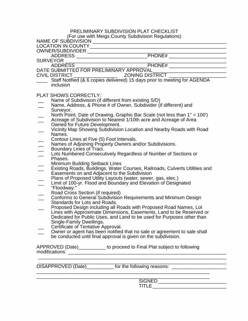
PRELIMINARY SUBDIVISION PLAT CHECKLIST (For use with Meigs County Subdivision Regulations)
NAME OF SUBDIVISION _________________________________________________ LOCATION IN COUNTY __________________________________________________ OWNER/SUBDIVIDER ___________________________________________________ ADDRESS __________________________ PHONE# _____________________ SURVEYOR ___________________________________________________________ ADDRESS __________________________ PHONE# _____________________ DATE SUBMITTED FOR PRELIMINARY APPROVAL ___________________________ CIVIL DISTRICT ________________ ZONING DISTRICT _____________________ ____ Staff Notified (& 6 copies delivered) 15 days prior to meeting for AGENDA
inclusion PLAT SHOWS CORRECTLY: __ Name of Subdivision (if different from existing S/D) __ Name, Address, & Phone # of Owner, Subdivider (if different) and
Surveyor. __ North Point, Date of Drawing, Graphic Bar Scale (not less than 1" = 100') __ Acreage of Subdivision to Nearest 1/10th acre and Acreage of Area
Owned for Future Development. __ Vicinity Map Showing Subdivision Location and Nearby Roads with Road
Names. __ Contour Lines at Five (5) Foot Intervals. __ Names of Adjoining Property Owners and/or Subdivisions. __ Boundary Lines of Tract. __ Lots Numbered Consecutively Regardless of Number of Sections or
Phases. __ Minimum Building Setback Lines __ Existing Roads, Buildings, Water Courses, Railroads, Culverts Utilities and
Easements on and Adjacent to the Subdivision __ Plans of Proposed Utility Layouts (water, sewer, gas, elec.) __ Limit of 100-yr. Flood and Boundary and Elevation of Designated
"Floodway." __ Road Cross Section (if required) __ Conforms to General Subdivision Requirements and Minimum Design
Standards for Lots and Roads. __ Proposed Design including all Roads with Proposed Road Names, Lot
Lines with Approximate Dimensions, Easements, Land to be Reserved or Dedicated for Public Uses, and Land to be used for Purposes other than Single-Family Dwellings.
__ Certificate of Tentative Approval. __ Owner or agent has been notified that no sale or agreement to sale shall
be conducted until final approval is given on the subdivision. APPROVED (Date)__________ to proceed to Final Plat subject to following modifications: __________________________________________________________ _____________________________________________________________________ _____________________________________________________________________ DISAPPROVED (Date)__________ for the following reasons: ____________________ ________________________________________________________________________________________________________________________________ SIGNED _________________________ TITLE ___________________________

FINAL SUBDIVISION PLAT CHECKLIST (For use with Meigs County Subdivision Regulations)
NAME OF SUBDIVISION _________________________________________________ LOCATION IN COUNTY _________________________________________________ OWNER/SUBDIVIDER ___________________________________________________ ADDRESS __________________________ PHONE# _____________________ SURVEYOR ___________________________________________________________ ADDRESS __________________________ PHONE# _____________________ DATE PRELIMINARY APPROVAL GRANTED BY MCRPC ______________________ CIVIL DISTRICT ________________ ZONING DISTRICT _____________________ DATE SUBMITTED TO STAFF FOR REVIEW AND AGENDA INCLUSION __________ PLAT SHOWS CORRECTLY: __ Name of Subdivison. __ Name, Address, & Phone # of Owner, Subdivider (if different) and Surveyor. __ North Point, Date of Drawing, Graphic Bar Scale (not less than 1" = 100'). __ Acreage of Subdivision to Nearest 1/10th acre. __ Vicinity Map Showing Subdivision Location and Nearby Roads with Road
Names. __ County Deed Book and Page Numbers for Property being subdivided. __ Lots Numbered Consecutively Regardless of Number of Sections or Phases. __ Minimum Building Setback Lines. __ Correct Sheet Size (20" x 20") __ Private covenants have been prepared for recording with plat. __ Limit of 100-yr. Flood and Boundary and Elevation of Designated "Floodway." __ Bearings and Distance to at least two of the following: Nearest Existing Road
Lines, Bench Marks or other permanent monuments. __ Boundary lines to 1/10th of a foot and Angles to the nearest minute (closure error
not over 1/5,000th). __ Monuments by type and location. __ Existing Roads, buildings, Water Courses, Railroads, Culverts, Utilities and
Easements on and adjacent to the subdivision. __ Names, locations of adjoining property owners. __ Location, Widths, and Names of all Roads within & Connecting to the Property. __ Sufficient Data Regrading Location, Bearing and Length of every Road Line,
whether Curved or Straight. __ Lot Line Dimensions to Nearest 1/10th foot and Bearings to Nearest Minute. __ Location of all Water Courses; Location & Size of Needed Drainage Structures. __ Owner's Certificate and Dedication. __ Surveyor's/Engineer's Certificate. __ Block with Signatures of: __ Health Department ___ County Road Department __ Road Status ___ Planning Commission __ Required Physical Improvements Have Been Made OR Bond Posted in Amount
of $____________ to Cover Cost of: ___________________________________ _______________________________________________________________ APPROVED (Date)__________ for recording: ________________________________ VARIANCES GRANTED: _________________________________________________ DISAPPROVED (Date)__________ for the following reasons: ____________________ _____________________________________________________________________ _____________________________________________________________________ SIGNED ________________________ TITLE______________________