may 1998 - amended 2013 · web viewthe white-faced storm-petrel, a colonially breeding small...
TRANSCRIPT

Mornington Peninsula National Park and Arthurs Seat State Park
May 1998 - Amended 2013
Management Plan

This Management Plan for Mornington Peninsula National Park and Arthurs Seat State Park is approved for implementation. Its purpose is to direct all aspects of management in the parks until the plan is reviewed. A Draft Management Plan was published in November 1996. A total of 36 submissions were received.
Copies of the Plan can be obtained from:
Parks Victoria378 Cotham RoadKEW VIC 3101
Parks Victoria Information Centre Vault 11Banana Alley Flinders StreetMELBOURNE VIC 3000
NRE Information Centre 8 Nicholson StreetEAST MELBOURNE VIC 3002
Parks Victoriac/- Dromana Information Centre Point Nepean RoadPO Box 192DROMANA VIC 3936
For further information on the Plan, please contact:
Bob BrinkmanChief Ranger - Mornington Westernport District, Parks Victoria Dromana Office,5987 2755

Amended 2013

2 Mornington Peninsula National Park and Arthurs Seat State Park
Published in May 1998 by Parks Victoria 378 Cotham Road, Kew, Victoria 3101.
National Library of Australia Cataloguing-in-Publication entry
Parks Victoria.Mornington Peninsula National Park and Arthurs Seat State Park management plan.
Bibliography.ISBN 0 7306 6743 X.
1. National parks and reserves - Victoria - Mornington Peninsula - Management. 2. National parks and reserves - Victoria - Arthurs Seat -. 3. Mornington Peninsula National Park (Vic.). 4. Arthurs Seat State Park (Vic.). I. Title.
333.783099452
Cover: Ocean, beach and bushland settings of the Parks (Photographs: Parks Victoria collection)
Printed on recycled paper to help save our natural environment

FOREWORD
Mornington Peninsula National Park and Arthurs Seat State Park
3
Mornington Peninsula National Park and Arthurs Seat State Park together contain the largest and most significant remaining vegetation on the Mornington Peninsula. The coastal sections in particular have spectacular scenic views and support important marine habitats as well as some of the highest densities of Aboriginal archaeological sites along the Victorian coast.
Mornington Peninsula National Park is a premiere attraction within Victoria’s highest visited tourist region and is the most visited national park in Victoria providing a diverse range of year-round activities close to Melbourne. The rugged coastline environments encompassing the historic forts at Point Nepean, Cape Schanck and expansive sandy beaches are among the many visitor attractions. Arthurs Seat State Park includes attractions such as the Seawinds Gardens and summit area and offers panoramic views across Port Phillip Bay and the southern Mornington Peninsula.
This Approved Plan provides for the protection of the Parks’ important natural and cultural features as well as ensuring a quality visitor experience.
I thank those individuals and organisations who made submissions on the Draft Plan and I look forward to the continuing community support in managing these Parks.
Marie Tehan MP Minister for Conservation and Land Management
4 Mornington Peninsula National Park and Arthurs Seat State Park
APPROVED MANAGEMENT PLAN
This approved Management Plan has been prepared under the provisions of section 17 of the National Parks Act 1975 (Vic.) and is approved for implementation.
The plan provides the basis for future management of Mornington Peninsula National Park and Arthurs Seat State Park. It was finalised following consideration of 36 submissions received on the Draft Plan.

SUMMARY
Mornington Peninsula National Park and Arthurs Seat State Park
5
Mornington Peninsula National Park (2686 ha) and Arthurs Seat State Park (572 ha) protect major natural and cultural heritage sites on the Mornington Peninsula and provide diverse recreation opportunities. Highlights include popular beaches, rugged coastal scenery and associated flora and fauna between Point Nepean and Flinders and diverse bushland in Greens Bush. Outstanding recreation opportunities include walking tracks along the coast, and in forested areas in Arthurs Seat State Park. Rich cultural heritage, including Aboriginal sites along the coast and historic fortifications at Point Nepean and South Channel Fort, is also of considerable significance.
These features and excellent access to the Parks have resulted in high visitor numbers, in fact Mornington Peninsula National Park is the most heavily visited national park in Victoria’s parks and reserves system. Sight-seeing, swimming, surfing, walking, picnicking and heritage appreciation are some of the most popular activities.
The Parks will be managed and protected as highly significant areas for conservation, recreation and education. They will be managed with particular attention paid to the protection of important species and communities from the impacts of pest plants and animals and inappropriate recreational activities.
High quality visitor experiences will be provided based on the outstanding opportunities provided by the Parks’ walking tracks, lookouts and other facilities. The Parks will become an increasingly important component of the high quality tourism experiences being developed on the Peninsula. This increased use will be largely outside the summer peak period and managed to ensure protection of heritage values.
Facilities and services available to visitors will be progressively upgraded to increase enjoyment and appreciation of the special values of the Parks.
Significant management directions for the Parks are summarised below.
· Significant flora and fauna, and other natural and cultural features will be protected.
· Weed and pest animal control and fire management will be undertaken to improve protection of significant remnant areas, and erosion works will be undertaken where appropriate.
· The Parks will be marketed as key attractions and conservation assets on the Mornington Peninsula, with outstanding natural and cultural values and diverse recreational opportunities.
· A comprehensive visitor facilities and tourism services strategy will be progressively implemented, particularly at major visitor destinations such as Cape Schanck, Point Nepean and Arthurs Seat, to enhance enjoyment of the Parks.
· The visual identity of the Parks will be upgraded, and orientation and information services improved, to assist visitors to locate and enjoy the diverse range of settings available consistent with codes of behaviour to promote low-impact use and safety.
· The walking track network will be enhanced to provide further outstanding opportunities to enjoy the best landscapes and bushland on the Peninsula.
· Monitoring of visitors will be improved to provide managers with better information on visitor numbers, satisfaction and needs.
· The tourism sector, local community, Mornington Peninsula Shire Council and other interested groups and individuals will be invited to participate more fully in management, interpretation and promotion of the Parks.

vi Mornington Peninsula National Park and Arthurs Seat State Park

CONTENTS
Mornington Peninsula National Park and Arthurs Seat State Park
7
FOREWORD iii
SUMMARY v
1 INTRODUCTION 3
1.1 Location and planning area 31.2 Regional context 31.3 Significance of the Parks 31.4 Creation of the Parks 41.5 Legislation and guidelines 51.6 Park management aims 5
2 STRATEGIC DIRECTIONS 7
2.1 Park vision 72.2 Management directions 72.3 Zoning 9
MORNINGTON PENINSULA NATIONAL PARK
3 RESOURCE CONSERVATION 15
3.1 Geological and landform features 153.2 Vegetation 153.3 Fauna 173.4 Landscape 183.5 Cultural heritage 19
4 PARK PROTECTION 22
4.1 Fire management 224.2 Pest plants and animals, and diseases 234.3 Soil conservation 25
5 THE PARK VISIT 26
5.1 The Park visitor 265.2 Marketing 285.3 Informing the visitor 30
5.3.1 Orientation 305.3.2 Interpretation and education 32
5.4 Visitor recreation 355.4.1 Day use areas 355.4.2 Major attractions 375.4.3 Vehicle access 395.4.4 Walking 405.4.5 Camping 445.4.6 Beach-going, surfing and fishing 45

5.4.7 Horse riding 465.4.8 Cycling 475.4.9 Hang gliding and paragliding 475.4.10 Fossicking 485.4.11 Dogs 48
8 Mornington Peninsula National Park and Arthurs Seat State Park
5.5 Commercial tourism operations 495.6 Public safety50
6 COMMUNITY AWARENESS AND INVOLVEMENT 52
6.1 Friends and volunteers 526.2 Community awareness and Park neighbours 526.3 Schools and other education 53
7 OTHER ISSUES 54
7.1 Authorised uses 547.2 Boundaries and adjacent land uses 55
8 IMPLEMENTATION 58
ARTHURS SEAT STATE PARK
9 RESOURCE CONSERVATION 63
9.1 Geological and landform features 639.2 Vegetation 639.3 Fauna 649.4 Landscape 649.5 Cultural heritage 65
10 PARK PROTECTION 67
10.1 Fire management 6710.2 Pest plants and animals, and diseases 6810.3 Soil conservation 69
11 THE PARK VISIT 70
11.1 The Park visitor 7011.2 Marketing 7111.3 Informing the visitor 73
11.3.1 Orientation 7311.3.2 Interpretation and education 74
11.4 Visitor recreation 7511.4.1 Day use areas 7511.4.2 Vehicle access 7611.4.3 Walking 7711.4.4 Camping 7911.4.5 Cycling 7911.4.6 Dogs 79
11.5 Commercial tourism operations 7911.6 Public safety 80

Mornington Peninsula National Park and Arthurs Seat State Park
9
12 COMMUNITY AWARENESS AND INVOLVEMENT 82
12.1 Friends and volunteers 8212.2 Community awareness and Park neighbours 8212.3 Schools education 83
13 OTHER ISSUES 84
13.1 Authorised uses 8413.2 Boundaries and adjacent land uses 84
14 IMPLEMENTATION 86
REFERENCES 87
TABLES
1 Mornington Peninsula National Park - Management zones and overlays 102 Arthurs Seat State Park - Management zones and overlays 11
Mornington Peninsula National Park3 Summary of recreation activities 294 Existing and proposed visitor orientation facilities 335 Existing and proposed interpretative facilities 346 Existing and proposed recreation facilities 367 Management of vehicle roads and tracks 418 Management of walking tracks 429 Authorised uses and occupations 5510 Priority management strategies 58
Arthurs Seat State Park11 Existing and proposed interpretation facilities 6612 Summary of recreation facilities 7213 Existing and proposed visitor orientation facilities 7514 Existing and proposed recreation facilities 7615 Management of vehicle roads and tracks 7816 Management of walking tracks 7817 Authorised uses and occupations 8518 Priority management strategies 86
APPENDICES
1 Significant geological and geomorphological features 892 Significant flora 913 Significant fauna 934 Significant historic sites 955 Major environmental weeds 96

10
Mornington Peninsula National Park and Arthurs Seat State Park
FIGURES
1 MPNP and ASSP Regional Locality Plan End of Plan2 MPNP Management Zones and Public Land Use "3 Access & Recreation Management "4 ASSP Management Zones and Public Land Use "5 Access & Recreation Management "
PLAN AMENDMENT
Attachment 1 and Maps 1, 2a, 2b, 3 and 4 End of Plan

MORNINGTON PENINSULA NATIONAL PARK AND
ARTHURS SEAT STATE PARK
INTRODUCTION AND
STRATEGIC DIRECTIONS

Introduction
Mornington Peninsula National Park and Arthurs Seat State Park
3
1 INTRODUCTION
This Plan covers both Mornington Peninsula National Park (MPNP) and Arthurs Seat State Park (ASSP). The Parks have been considered together in the planning process, particularly in relation to regional issues, but a range of management aims and actions are specific to each Park. This is reflected in the plan format: Sections 1 and 2 deal with both Parks together, after which the document is divided into separate sections dealing with each Park.
1.1 Location and planning areaSituated about 70 kilometres south of Melbourne, Mornington Peninsula National Park runs along the coast from Point Nepean, at the western tip of the Mornington Peninsula, to Bushrangers Bay, where it turns inland along the Main Creek valley, still as a narrow band, until it joins the more expansive Greens Bush section of the Park. A narrow coastal strip between Simmons Bay and Flinders also forms part of the Park, as does South Channel Fort in Port Phillip Bay (figure 1).
Arthurs Seat State Park embraces the western and northern escarpments of Arthurs Seat, a prominent landmark on the Mornington Peninsula. The Park is about 60 kilometres from Melbourne and three kilometres north of the Greens Bush section of Mornington Peninsula National Park (figure 1).
This management plan covers:
· Mornington Peninsula National Park (2686 ha);
· Arthurs Seat State Park (572 ha), including two areas which will be added to the Park: the McKellar Flora Reserve area (43 ha) upon transfer of the title to the Crown and part of the Tower Hill Road link(1.3 ha).
1.2 Regional contextThe Mornington Peninsula is the most popular informal recreation area in Victoria and has been described as ‘Melbourne’s Playground’.
Both Parks contribute significantly to the attraction of the Peninsula while being popular
in their own right. Mornington Peninsula National Park is the most visited park in the State.
Mornington Peninsula National Park provides the setting for most of the recreation activities on the south of the Peninsula, including year- round beach activities such as surfing, scuba diving, walking, horse riding, hang gliding and coastal viewing. The network of walking tracks offers much variety, and both Parks are popular for nature study and observation as well as heritage appreciation. Greens Bush in Mornington Peninsula National Park and areas of Arthur Seat State Park are the most natural settings for nature-based activities.
The Parks are bordered by a range of land uses including urban development, farms, townships and golf courses. Commonwealth land (the former Army Logistics Training Centre) is located between two sections of Park at Point Nepean. The Harold Holt Marine Reserve abuts the Point Nepean section of Mornington Peninsula National Park.
1.3 Significance of the ParksMornington Peninsula National Park and Arthurs Seat State Park make valuable contributions to Victoria’s parks system, which aims to protect viable, representative samples of the State’s natural environments. Parks also enable visitors to enjoy and appreciate natural and cultural values, and many make important contributions to tourism and present important opportunities for research.
Mornington Peninsula National Park is assigned Category II of the IUCN United Nations’ list under National Parks and Protected Areas. Category II areas are managed primarily for ecosystem conservation and appropriate recreation.
Arthurs Seat State Park is assigned Category III under the IUCN United Nations’ list of National Parks and Protected Areas. Category III areas are managed mainly for the conservation of specific natural features.

Introduction
4 Mornington Peninsula National Park and Arthurs Seat State Park
Both Parks are also listed on the Register of the National Estate, in recognition of their outstanding values and their importance as part of our heritage.
Significant features of the Parks are summarised below.
Natural values· Largest and most significant remaining
areas of native vegetation on the Mornington Peninsula.
· Numerous sites and features of geomorphic significance, particularly along the coast (cliffed calcarenite coast, sandy forelands and basalt shore platforms).
· Only representation in the Victorian conservation reserve system of four particular land systems formed within the Southern Victorian Coastal Plains and the Southern Victorian Uplands.
· Many significant native plants and vegetation communities, especially in Greens Bush and former McKellar Flora Reserve, and the most extensive remnant coastal grassy forest habitat on the Mornington Peninsula.
· Highly scenic landscape values along the ocean coast and at Port Phillip heads and the prominent landscape feature of Arthurs Seat.
· Many significant fauna species, including populations of the nationally significant Hooded Plover, over 30 species of State significance and many species of regional significance.
· High quality marine and intertidal habitats, with some pristine areas within Point Nepean.
Cultural values· Nationally significant and fascinating
historic sites at Point Nepean.
· Sites near Sorrento Ocean Beach associated with early recreational activities in the area dating back to the 19th century.
· The historic Seawinds Gardens in Arthurs Seat State Park.
· One of the highest recorded densities of Aboriginal archaeological sites along the Victorian Coast (MPNP).
· South Channel Fort is an important component of the historic fortification defence system of Port Phillip (and an important bird nesting and roosting site).
Tourism and recreation values· Spectacular scenery and popular surf
beaches associated with a wild and rugged coastline.
· The closest opportunities to Melbourne to experience Bass Strait coastal environments.
· A variety of year-round activities, which are part of the total recreational and tourism experience of the Mornington Peninsula.
· Local and regional economic benefits.
· Intensively used recreational nodes, e.g. at Portsea, Sorrento, Cape Schanck and Arthurs Seat.
· The most extensive system of walking tracks in coastal and bushland settings on the Mornington Peninsula, with panoramic views across the bay, ocean and southern Peninsula.
· Diverse opportunities for education and school visits.
1.4 Creation of the ParksThe former Cape Schanck Coastal Park, incorporating the then existing coastal reserve (which was managed by a committee of management) was declared on 1 December 1975 (900 ha) as a result of the National Parks Act 1975 (Vic.). On 16 May 1978, as a result of the National Parks (Amendment) Act 1978 (Vic.), Nepean State Park (which included the northern section of Greens Bush and most of what is now Arthurs Seat State Park) was created. Land in the Arthurs Seat area was first reserved for public purposes in 1863. The

Introduction
Mornington Peninsula National Park and Arthurs Seat State Park
5
Seawinds property was purchased by the government in 1975.
Between 1978 and 1987 several additions were made to both parks, and in 1988, following acquisition of additional land at Greens Bush and Commonwealth land at Point Nepean, the areas became the Point Nepean National Park (2200 ha) and Arthurs Seat State Park(350 ha).
Further areas were added to Point Nepean National Park, including South Channel Fort in 1995 when its name was changed to Mornington Peninsula National Park (2686 ha).
In its 1994 review, the former Land Conservation Council (LCC 1994) endorsed the existing status of Mornington Peninsula National Park because the Park has importance for the representation of land systems, contains the largest remaining area of remnant native vegetation on the Peninsula with associated significant flora and fauna and recreation values, and has nationally significant historical values at Point Nepean and South Channel Fort.
The LCC review in 1994 recommended a number of additions to Arthurs Seat State Park. Most of these areas (including the Arthurs Seat Public Park and Parkdale block) were proclaimed as part of the Park in June 1997. When the McKellar Flora Reserve area (currently owned by the Trust for Nature) and part of the Tower Hill Road link are transferred to the Crown, the total area of the Park will be 572 ha.
1.5 Legislation and guidelinesMornington Peninsula National Park and Arthurs Seat State Park are reserved and managed under the National Parks Act. The Act requires the Director to preserve and protect the natural environment of the Parks and their natural and other features and, subject to this, to provide for the use of the Parks by the public for enjoyment, recreation and education. The Act also provides for appropriate research.
The LCC (1994) recommendation that the chairlift operation within the former Arthurs Seat Public Park continue by arrangement
under the leasing provisions of the National Parks Act was included in the legislation which provide for the addition of this area to the Park.
The Environment Conservation Council (ECC) will finalise the Marine and Coastal Special Investigation commenced by the former LCC. This will give direction for the management and use of the marine areas abutting the Point Nepean section of the Mornington Peninsula National Park.
The Parks are managed in accordance with Parks Victoria guidelines for the management of parks and LCC recommendations and other plans and guidelines, including:
· (former) Dandenong Region Fire Protection Plan (CNR 1992);
· Point Nepean National Park, Point Nepean Section Management Plan (CFL 1989);
· Point Nepean and South Channel Fort Conservation Plans (Historic Buildings Branch 1990; Honman & Historic Buildings Branch 1990).
The management strategies within the Point Nepean Sector Management Plan remain in place unless amended in this plan.
1.6 Park management aimsSections 4 (Objects) and 17 of the National Parks Act provide the basis for management of the Parks. The following management aims are derived from those sections and as such broadly govern all aspects of park management.
Resource conservation· Preserve and protect the natural
environment.
· Allow natural environmental processes to continue with the minimum of interference.
· Maintain biodiversity.
· Conserve features of archaeological, historical and cultural significance.

Introduction
6 Mornington Peninsula National Park and Arthurs Seat State Park
Park protection· Protect water catchments and streams.
· Protect human life, the Parks and adjacent lands from injury by fire.
· Eradicate, or otherwise control, introduced plants, animals and diseases.
The Park visit· Provide opportunities for appropriate
recreation and tourism.
· Promote and encourage an appreciation, understanding and enjoyment of the Parks’ natural and cultural values and their recreational opportunities.
· Encourage appropriate park use and visitor behaviour, and foster a conservation ethic in visitors and an understanding of minimal impact behaviour.
· Take reasonable steps to ensure the safety of visitors.
Other· Provide for and encourage scientific
research, surveys and monitoring that will contribute to a better understanding and management of the Parks.
· Co-operate with local, State and Commonwealth government authorities, the community and other interested organisations to assist in the management of the Parks.

Strategic directions
Mornington Peninsula National Park and Arthurs Seat State Park
7
2 STRATEGIC DIRECTIONS
2.1 Park visionFuture visitors to Mornington Peninsula National Park and Arthurs Seat State Park perceive the Parks as an integral part of the total experience of the Mornington Peninsula and as important components of Victoria’s parks system. They are aware that the Parks have special natural and cultural values not found elsewhere on the Peninsula, and high value coastal characteristics and attractions not found elsewhere in Victoria. Through an emphasis on the Parks as a whole system, each Park is perceived as a unified and coherent experience rather than a series of unrelated destinations.
Mornington Peninsula National Park continues to be Victoria’s most visited national park, and both Parks combined provide a variety of activities and attractions linked through a ‘Peninsula parks drive’. The Parks draw a broad range of visitors which come from the local area (residents, holiday makers), the Port Phillip region, interstate and overseas, and the Parks offer opportunities targeted to each of these market segments. The Parks are enjoyed in all seasons, and, while the beaches remain popular summer destinations, the growth in visitor numbers has been largely in other parts of the Parks.
The summit at Arthurs Seat is a focal point for visitors following the improvement of the amenity of the precinct and the provision of high quality orientation, interpretation and education material about the Parks. This is reinforced by information about the Parks at all major visitor destinations.
At Cape Schanck there are improved visitor facilities and educational services integrated with the lighthouse area, while at Point Nepean and South Channel Fort there is improved access, and information and promotional programs. The major ocean beach areas have high quality facilities of sensitive design and consistent style and information that attracts beach-goers to enjoy the other opportunities in the Parks. There are appropriately located
commercial opportunities which offer a range of tourist support facilities and services.
The Parks are managed to maintain biodiversity and significant flora and fauna, particularly the important conservation areas of Greens Bush and Point Nepean.
The superb European cultural heritage sites at Point Nepean are a major attraction, and there is a greater awareness of the European cultural sites elsewhere in the Parks through improved interpretation. The rich Aboriginal cultural heritage of the coastal areas is appropriately protected and a focal point for some visitors, especially international visitors, and is interpreted at several sites.
There is a sense of ownership of the Parks by the local community that has been encouraged through Friends groups, volunteers, education and other initiatives.
2.2 Management directionsMajor management directions for the Parks are outlined below.
Mornington Peninsula National Park
Resource conservation· A greater emphasis will be given to
protecting and enhancing the Park’s biodiversity.
· Ongoing research will be encouraged and additional surveys undertaken to update Park resource information.
· A co-ordinated information base will be developed to incorporate and update all surveys, research and monitoring results.
· Significant flora species and communities will be given special protection.
· Weed control and fire management will be undertaken to manage significant remnant areas, especially in Greens Bush.
· Significant fauna species and habitats will be protected, especially the Hooded Plover and other threatened fauna.

Strategic directions
8 Mornington Peninsula National Park and Arthurs Seat State Park
· Landscape qualities along the coast will be maintained and enhanced.
· Aboriginal archaeological sites and non- Aboriginal historic sites and landscapes will be protected, particularly at Point Nepean.
Park protection· The Park and neighbouring assets will be
protected against wildfires. Fuel reduction burning will not be undertaken along the narrow section of the coast.
· The spread of Cinnamon Fungus into and within the Park will be minimised.
· Pest plant control will be undertaken in accordance with a strategy that will prioritise weeds, emphasise the protection of significant communities and encourage good neighbour practices.
· Pest animal control will continue; further programs will be established at Greens Bush and Point Nepean and other priority sites.
· Disturbed areas along the coast will be managed to protect significant natural, cultural and landscape features.
The Park visit· The Park will be promoted to Victorian,
interstate and international visitors as a major attraction and unique destination on the Peninsula. Distinctive imaging for the Park’s key strengths will be developed for future marketing.
· Facilities and services at major visitor precincts will be improved, including those at Cape Schanck, Point Nepean and other major ocean beach destinations, and at South Channel Fort.
· Ongoing monitoring of visitors will be undertaken to determine numbers, levels of recreational activity and impacts.
· Visitor enjoyment of the Park will be enhanced by improved pre-visit information and orientation and interpretative facilities and services linked with other tourist attractions on the
Peninsula, ultimately increasing the levels of net benefits to the region.
· Visitor numbers will be increased in off- peak periods; Point Nepean will be promoted to increase visitor numbers.
· A designated walking track network will be enhanced and maintained to a high standard.
· The commercial sector will be encouraged to provide quality tourist support facilities and services at key attractions.
Community awareness and involvement· Volunteers will be encouraged to be
involved in resource conservation and monitoring programs.
· Park neighbours will be encouraged to assist in park protection. Existing volunteer and Friends groups will be encouraged.
· School visits will be promoted to key sites such as Point Nepean and Cape Schanck.
Arthurs Seat State Park
Resource conservation· Biodiversity conservation programs will be
given a greater emphasis.
· Biological surveys to identify flora and fauna will be conducted.
· A co-ordinated information base will be developed to incorporate and update all surveys, research and monitoring results.
· Areas and sites of flora and fauna significance will be given special protection.
Park protection· Environmental weeds will be controlled
and a pest plant strategy developed.
· The Park and neighbouring assets will be protected against wildfires by continuing a role in emergency response, and focusing on slashing and firebreaks.
The Park visit

Strategic directions
Mornington Peninsula National Park and Arthurs Seat State Park
9
· The Park will be promoted in conjunction with the Mornington Peninsula National Park as a key regional attraction providing all-year round sightseeing and nature- based activities.
· Visitor enjoyment of the Park will be enhanced by improved tourist facilities and services, including a potential visitor centre and high quality information services about the Park and other park attractions.
· Arthurs Seat will be upgraded as a key tourist destination following preparation of a development plan for the visitor precinct.
· Ongoing monitoring of visitors will be undertaken to determine numbers, levels of recreational activity, and impacts.
· The walking tracks will be upgraded and consolidated to establish and improve links between park areas.
Community awareness and involvement· The volunteer resource will continue to
be encouraged.
· Extensive volunteer weed control programs will continue to be undertaken.
2.3 ZoningA park management zoning scheme has been developed for each Park to:
· provide a geographic framework in which to manage the Parks;
· indicate which management directions have priority in different parts of the Parks;
· indicate the types and levels of use appropriate throughout the Parks;
· assist in minimising existing and potential conflicts between uses and activities, or between those and the protection of park values;
· provide a basis for assessing the suitability of future activities and development proposals.
Three management zones apply to the Parks: Conservation, Conservation and Recreation, and Recreation Development. Overlays are also used to indicate management requirements additional to those of the underlying management zones.
The zones and overlays in Mornington Peninsula National Park are described in table 1 and figure 2.
The zones and overlays in Arthurs Seat State Park are described in table 2 and figure 4.

CONSERVATION CONSERVATION AND RECREATION
RECREATION DEVELOPMENT
SPECIAL PROTECTION AREA
SPECIAL MANAGEMENT
LAND USE DESIGNATION
AREA(PUBLIC UTILITY)
(FOSSICKING)
548.5 ha, 20.4% of 2070.5 ha, 77.1% of 67 ha, 2.5 % of the Sites near Main Various localities Stockyard to Doublethe Park. the Park. Park. Creek, Bushrangers
Bay Track and in Greens Bush.
(table 9) — notmapped.
Creeks.
Relatively broad areas Areas of sensitive All existing major Threatened flora Point Nepean Zeolite fossickingof sensitiveenvironments at Point Nepean and Lightwood Creek Catchment.
environments orless sensitive natural environments supporting a range of geological, cultural and recreation values.
facilities and sites,and visitor areas for upgrading.
populations. navigation facilities,Sorrento phone towers, Sorrento water tanks, Boag’s Rocks sewerage outfall.
zone.
Protect sensitive Protect less Provide primarily Protect specific Highlight areas or Provide for specificnatural environments sensitive natural for high use visitor natural or cultural sites where special legislativeand provide forminimal impact recreation activities and simple visitor facilities subject to ensuring minimal interference to natural processes.
environments andprovide for sustainable dispersed recreation activities and small- scale recreation facilities without significant impact on natural processes.
precincts with aconcentration of recreation and/or interpretation facilities.
values in specificareas and sites where a special management focus is required.
managementprovisions are needed to provide for a particular non- standard use or activity.
requirements.
Strategic directions
Strategic directions
TABLE 1 MORNINGTON PENINSULA NATIONAL PARK - MANAGEMENT ZONES AND OVERLAYS
ZONE OVERLAY
AREA/ LOCATION
VALUES
GENERAL MANAGEMENT AIM

52 ha, 8 % or the Park. 557 ha, 91 % of the Park.
8 ha, 1 % of the Park. Note: final zone boundaries for the Arthurs Seat visitor precinct will be determined in the development plan (section 11.4.1).
Sites near the Cook Street Spur and in the McKellar Flora Reserve.
Various localities(table 15) – not mapped.
Relatively broad areas of sensitive environments and significant vegetation communities.
Majority of the Park incorporating areas with conservation and recreation values.
Existing major facilities at Seawinds, and proposed upgrade of Arthurs Seat and base of the chairlift.
Threatened flora populations.
Protect sensitive natural environments and provide for minimal impact recreation activities and simple visitor facilities subject to ensuring minimal interference to natural processes.
Protect less sensitive natural environments and provide for sustainable dispersed recreation activities and small-scale recreation facilities without significant impact on natural processes.
Provide primarily for high use visitor precincts with a concentration of recreation and/or interpretation facilities.
Protect specific natural or cultural values in specific areas and sites where a special management focus is required.
Highlight areas or sites where special management provisions are needed to provide for a particular non-standard use or activity.
TABLE 2 ARTHURS SEAT STATE PARK - MANAGEMENT ZONES AND OVERLAYS
ZONE OVERLAY
Strategic directions
CONSERVATION CONSERVATION AND RECREATION
RECREATION DEVELOPMENT
SPECIAL PROTECTION AREA
SPECIAL MANAGEMENT AREA (PUBLIC UTILITY)
AREA/LOCATION
VALUES
GENERAL MANAGEMENT AIM

Strategic directions
Mornington Peninsula National Park and Arthurs Seat State Park
12
MORNINGTON PENINSULA
NATIONAL PARK

Strategic directions
13 Mornington Peninsula National Park and Arthurs Seat State Park

Mornington Peninsula National Park and Arthurs Seat State Park
14
Strategic directionsResource conservation
3 RESOURCE CONSERVATION
3.1 Geological and landform features
Mornington Peninsula National Park’s main landform feature is the extensive coastline dominated by sand dunes, cliffs, headlands, wide shore platforms and nearshore reefs.Point Nepean to Gunnamatta consists mainly of cliffs of Pleistocene dune limestone. Coastal outcrops of older volcanic basalts occur from Fingal and Cape Schanck to Flinders.
Most of the coastal section of the Park has been identified as having geological and geomorphological significance (appendix 1).
The Cape Schanck area from Fingal Beach to Bushrangers Bay is a relatively undisturbed area with many significant geological features. These include Angel Cave, which is of State significance, coastal cliffs, basalt shore platforms and the trace of Selwyn Fault. Despite isolated cases of vandalism, Angel Cave is under little threat from visitor impact because of the controlled access.
An internationally significant site for zeolite minerals is located at Cairns Bay (section 5.4.10).
Aims
· Minimise impacts from visitors on sensitive geological features.
· Protect significant dune systems.
· Provide opportunities for appropriate research, appreciation and education of geological and geomorphological sites and processes.
· Allow natural environmental processes to continue with minimum disturbance.
· Protect significant historical sites and structures from coastal erosion.
Management strategies
· Manage Angel Cave in accordance with the management recommendations of the Victorian Caves and Karst management report (Davey & White 1986).
· Monitor Angel Cave and discourage access to the shore between Cape Schanck and Fingal Beach.
· Provide interpretation material at significant sites such as Point Nepean and Cape Schanck (section 5.4.2).
· Manage zeolite areas in accordance with section 5.4.10.
· Manage coastal dune areas in accordance with section 4.3.
· Monitor cliff areas for disturbance and erosion and discourage visitor access, other than on designated walking tracks.
· Continue to undertake erosion control works at Point Nepean where the Park’s significant natural values and historical sites are threatened.
· Monitor changes to coastal areas and prioritise areas for erosion control works.
3.2 VegetationThe Mornington Peninsula has been largely cleared of native vegetation. Mornington Peninsula National Park and Arthurs Seat State Park contain the largest and most important areas of native vegetation remaining on the Peninsula.
Although some vegetation surveys have been undertaken, there has been no consistent and comprehensive flora survey of the Park.
The Park contains nine species considered rare or threatened in Victoria and over 40 species that are rare or uncommon on the Mornington Peninsula (appendix 2). Most sites where significant species are located are relatively isolated and will need to be managed on an ‘as need’ basis. A population of the endangered Purple Eyebright is located in Greens Bush and will require on-site management including monitoring. Active monitoring and weed control occurs in strategic areas for the

Resource conservation
Mornington Peninsula National Park 15
protection of Leafy Greenhood and Dainty Maidenhair.
The native vegetation communities found within the Park include (LCC 1991):
· Coastal dune scrub;· Coastal grassy forest;· Coast banksia woodland;· Sand heathland;· Coastal heathland;· Foothill forest;· Heathy woodland;· Riparian forest/thicket;· Swamp heathland;· Swamp sedgeland.
Non-indigenous pasture occurs in areas of Greens Bush and at Highfield. These provide grazing for kangaroos.
A number of vegetation communities, particularly coastal grassy forest, coast banksia woodland and sand heathland, have been greatly depleted since European settlement, and are of particular conservation significance. Parts of the Flinders coastal section of the Park have been depleted of native vegetation principally due to a long history of grazing. Management should aim at enhancing and retaining the diversity of vegetation communities by the use of fire, pest plant and animal control and visitor management.
Greens Bush has a varied land use history including grazing and cropping activities in some areas, but the Lightwood Creek catchment area is one of the least disturbed sites within the Park and includes significant heathlands.
Major threats to the vegetation in the Park are soil disturbance from recreation activities both inside and adjacent to the Park, inappropriate fire regimes, invasion by both native and exotic species, and dune destabilisation in coastal communities. Cinnamon Fungus is a significant problem in Greens Bush(section 4.2).
Vegetation linkages will be an important component in managing remnant communities on the Peninsula. The key corridor in the Park is Main Creek, connecting Greens Bush with Bushrangers Bay.
Fire is important for the maintenance of heathy vegetation types and the areas with more grassy understoreys in Greens Bush (section 4.1).
Aims
· Conserve native plant communities in their natural condition and maintain and enhance habitat diversity while allowing natural environmental processes to continue.
· Improve knowledge of flora in the Park and associated management requirements.
· Provide special protection for significant plant species and communities.
Management strategies
· Manage Flora and Fauna Guarantee listed species, communities and potentially threatening processes according to approved Action Statements.
· Undertake flora surveys and encourage flora research on significant species and communities. Establish (and continually update) a significant flora database in conjunction with volunteers, Friends groups and naturalists.
· Actively manage vegetation communities to retain habitat and community diversity by giving priority to the control of pest plants, appropriate fire regimes and encouragement of natural regeneration. Ensure that management protects and enhances threatened and significant species (appendix 2).
· Map and monitor vegetation communities, sites of significant vegetation and locations of significant species.
· Develop management guidelines and a monitoring program for Purple Eyebright and undertake surveys in Sand heathland communities in Greens Bush for its presence.
· Prepare and implement a revegetation program to enhance the Main Creek corridor and the Flinders coastal section.

17
Mornington Peninsula National Park
Resource conservation
· In implementing a revegetation program, retain strategic open areas at Highfield for kangaroo grazing (section 3.3).
· Ensure that monitoring and research on significant plant species assesses any impacts from kangaroos.
· Continue to liaise with landholders, the Mornington Peninsula Shire Council (Shire) and others as appropriate to encourage the maintenance, enhancement and addition of ecological corridors (including roadsides) that connect with the Park (sections 6.2 and 7.2).
3.3 FaunaThe Park plays a vital role in fauna conservation. Around 30 species listed as threatened in Victoria have been recorded in the Park and it supports significant populations of one nationally significant species, the Hooded Plover. A number of species are listed under the Flora and Fauna Guarantee Act 1988 (Vic.) (appendix 3).
The Park also supports a diverse fauna, particularly of birds, that is regionally important as a major contributor to the conservation of biodiversity on the Peninsula. The known native fauna of the Park comprises 32 mammals, 167 birds, 22 reptiles, 7 amphibians and 2 freshwater fish (NRE database 1997a).
Regionally important species include the White- footed Dunnart, Long-nosed Bandicoot, Black Wallaby, Singing Honeyeater, Spiny-cheeked Honeyeater and Blue-winged Parrot.
Over the past four years special management and monitoring of the Hooded Plover has been undertaken along the ocean beaches in partnership with volunteers.
The White-faced Storm-Petrel, a colonially breeding small seabird, breeds on South Channel Fort. This is the second largest colony in Victoria and one of only three breeding colonies in the State.
Other significant species require habitat protection and enhancement measures through
the use of fire, the control of pest plants and animals, and track rationalisation.
The key fauna habitat areas in the Park are:
· the relatively large and isolated coastal and hinterland areas at Point Nepean;
· the ocean beaches and dunes;
· the woodlands and heaths of Greens Bush;
· South Channel Fort (which is listed on the Register of the National Estate largely due to the presence of the White-faced Storm- Petrel colony).
The Point Nepean area supports a range of species that are not well represented in coastal parks elsewhere in the State, for example bandicoots and possibly the New Holland Mouse. Further survey work is required in this area. Because of its geographical location, Point Nepean is one of only a few sites in Victoria that may benefit from a predator exclusion zone. If implemented, such an exclosure could increase wildlife populations and enhance wildlife viewing opportunities.
The intertidal zone (within the Park boundary) is being significantly affected by the collection of shellfish and marine invertebrates, particularly the Fingal Beach — Cape Schanck area. Although shellfish species are protected under the Fisheries (Shell Fish Protection) Regulations 1993 (Vic.), intertidal species are being depleted.
Greens Bush supports the largest population of Eastern Grey Kangaroos on the Mornington Peninsula. This population moves freely in and out of the Park and pasture areas within the Park and surrounding properties provide grazing areas. An integrated approach to kangaroo management across public and private land is required and development of a management strategy is primarily the responsibility of Department of Natural Resources and Environment (NRE).
Numbers of kangaroos are not confirmed but there appears to have been an increase since the area was declared Park. This is supported by an increase in requests for control by Park neighbours in recent years. Current impacts on adjacent areas include damage to fences, loss of

Resource conservation
Mornington Peninsula National Park and Arthurs Seat State Park
18
forage and road safety issues. If the kangaroo population increases there is potential for ecological damage within the Park. However, if pasture areas within the Park are reduced this may affect the availability of forage areas and potential tourism opportunities (Highfield is an important area for kangaroo viewing).
The large Silver Gull population on South Channel Fort affects the visual appearance of the site, is in direct competition with White- faced Storm-Petrels and may impede recreation opportunities.
A small population of introduced Fallow Deer occurs in Greens Bush. Although deer are protected wildlife under the Wildlife Act 1985 (Vic.), there may be impacts on natural values. Some illegal hunting has occurred in the past.
Aims
· Conserve native fauna species and maintain the integrity of their habitats.
· Provide special protection for significant fauna.
· Protect genetic diversity of native populations and maintain habitat diversity.
Management strategies
· Manage Flora and Fauna Guarantee Act listed species and potentially threatening processes according to approved Action Statements.
· Conduct fauna surveys giving priority to mammals, reptiles and amphibians in key habitat areas.
· Maintain and enhance fauna habitat quality through the control of pest plants and diseases, and in the coastal section undertake appropriate weed control and track rationalisation.
· Continue to monitor the Hooded Plover population and introduce additional management measures for the population, including signage and fencing (particularly during nesting activity), closure of sections of the horse riding beach, increased ranger presence and fox control in appropriate
areas, to ensure that the Park continues to support a viable population of this species.
· Develop fauna habitat management plans for Point Nepean (in conjunction with the Department of Defence) and Greens Bush, and for the White-faced Storm-Petrel colony at South Channel Fort. Ensure that fauna management strategies focus on threatened and regionally significant species (appendix 3).
· Investigate the feasibility of a predator exclusion zone at Point Nepean, and implement if appropriate.
· Determine measures to minimise the impacts of Silver Gulls at Southern Channel Fort in the preparation of the fauna management plan for the site.
· Support NRE in implementing an integrated kangaroo management strategy incorporating measures determined necessary to manage impacts on natural values in the Park.
· Develop information signs for the protection of the intertidal zone including shellfish regulations, and formalise signage at key access points.
· Continue to participate in pre-park visit education programs about shellfish and marine habitat protection, e.g. providing newspaper articles.
· Seek additional protection mechanisms for the intertidal zone (e.g. protection under the Fisheries Act 1995 (Vic.) and under the National Parks Act).
· Monitor the deer population in Greens Bush, and consider controls as necessary to protect natural values.
3.4 LandscapeThe coastal landscapes are some of the best in Victoria and have been recognised in National Trust landscape classifications of Point Nepean, Diamond Bay, ‘The Cups’ (near Cape Schanck), Cape Schanck, Lower Main Creek,

Resource conservation
19
Mornington Peninsula National Park
most of Greens Bush and the Bass Strait Coastline (CNR 1996). These landscape values make a major contribution to the experience of many visitors.
Most of the Park is situated within the Coastal Landscape Character Type (Leonard & Hammond 1984) characterised by sandy beaches interspersed with calcarenite cliffs. At Cape Schanck the contrast between the dune calcarenite of the coast and the towering basaltic cliffs is striking (Leonard & Hammond 1984). Many of the natural transitions between adjacent landscape character types on the Mornington Peninsula have been lost because of development. However, the transition to the Southern Lowlands Character Type has been preserved at Greens Bush.
The coastal landscapes are particularly sensitive to visual intrusions because of the sparse vegetation, long distance visibility and proximity to residential and other development. The impact of non-indigenous vegetation is evident along some of the boundaries adjacent to housing, and in picnic areas where pine trees remain.
There are sites within the Park, such as some car parks or roads, that have been constructed without adequate design guidelines.
Much of the adjacent land in the coastal area between St Andrews and Portsea is subject to planning scheme provisions which emphasise protection of the special coastal landscape character and the need for development to have due regard to the adjacent Park.
Pressure to develop land close to the Park may increase in some areas with potential impact on the Park’s landscape values.
Aim
· Protect and preserve the landscape values of the Park in areas of scenic quality and viewer interest, especially along the coastal section.
Management strategies
· Continue to liaise with the Shire to minimise visual impacts of adjacent development on Park landscapes, and support initiatives to improve the landscape character in adjacent areas.
· Use landscape design expertise and follow Parks Victoria guidelines in facility design and construction, including redevelopment of intrusive facilities, e.g. car parks, roads and buildings.
· Progressively reinstate indigenous vegetation, including replacement of pines and revegetation of cleared areas where appropriate (sections 3.2 and 4.2).
3.5 Cultural heritageThe Bunurong clan Burinyung-Bulluk occupied the southern section of the Mornington Peninsula (belonging to Point Nepean and Cape Schanck) (Barwick 1984).
The Park contains a wide range and large number of Aboriginal archaeological sites. The density of sites in the coastal zone is among the highest recorded in Victoria.
All Aboriginal material and sites are protected under the Archaeological and Aboriginal Relics Preservation Act 1972 (Vic.) and the Aboriginal and Torres Strait Islanders Heritage Protection Act 1984 (Cwlth).
A comprehensive archaeological survey of the Mornington Peninsula was undertaken by Sullivan (1981). Over 200 Aboriginal archaeological sites have been recorded in the Park (Site Register, Aboriginal Affairs Victoria). These are predominantly shell middens, ranging from extensive and stratified shell deposits to small surface scatters. Stone artefacts occur at some sites, sometimes in large numbers. Cumulatively the sites have a high scientific, cultural and educational significance.
Management of these sites needs to address the impact of natural processes, park visitors (particularly the aggregation of walking tracks, the impact of horse riders and the collection of

Resource conservation
Mornington Peninsula National Park and Arthurs Seat State Park
20
artefacts), and adjacent urbanisation and revegetation works.
The Wurundjeri Tribe Land Compensation and Cultural Heritage Council is the relevant authority for cultural heritage in the Park.
The Mornington Peninsula has a varied history. Significant events include the first attempted European occupation in Victoria in 1803, followed by land settlement and a lime-burning industry, resort development and the operation of the defence installations and the quarantine station at Point Nepean.
Point Nepean is one of the key sites in Victoria’s defence history, it is the site where fortifications were developed in 1882 to protect Port Phillip Bay. Today South Channel Fort and Fort Nepean are of national historical significance, and many important fortifications and related structures can be seen (appendix 4). Fort Nepean is a popular visitor destination containing interesting displays and interpretation material. Pearce Barracks, the last remaining barracks on the Peninsula, is of considerable historic significance.
Twenty shipwrecks have been recorded in the Point Nepean area alone and a total of approximately 80 near the Park (CFL 1989; CNR 1996). The area is also notable as the location of the disappearance of Prime Minister Harold Holt (Cheviot Beach).
Occupation of the Peninsula during the mid- nineteenth century also led to a number of impacts on natural values. The coastal areas were disturbed by timber-cutters and lime- burners who removed many large trees and mined limestone (Calder 1986).
Prior to the purchase by the State Government, much of Greens Bush was grazed by cattle. The northern section was also cropped between 1975 and 1985 (Costello, Jenkins & Muller 1991).
The lighthouse complex at Cape Schanck, while not within the Park boundary, is highly significant.
The Sorrento Ocean Beach area was a popular destination for recreation at the turn of the century. Several sites relating to this period remain, e.g. parts of Coppins Track. In more
recent times, changing community attitudes to conservation and resource use have led to an increasing interest in the history and values of the Park.
Limited conservation works have been undertaken on non-Aboriginal historic sites. Some stabilisation has occurred at Point Nepean, but many high-cost tasks remain if recommendations in conservation plans for Point Nepean and South Channel Fort are to be implemented (Historic Buildings Branch 1990; Honman & Historic Buildings Branch 1990). Apart from these two major sites, little research appears to have been undertaken on non- Aboriginal historical sites.
Interpretation of historic sites is a major visitor theme. Interpretation of the sites at Point Nepean is of a high standard, but opportunities exist to improve interpretation at other sites, as provided for in section 5.3.2.
There is an opportunity to improve presentation and interpretation of the original gun barrels at Point Nepean.
Aims
· Protect all Aboriginal archaeological sites.
· Interpret the Aboriginal cultural heritage values of the Park.
· Conserve significant features and landscapes of historic and cultural significance.
· Interpret the cultural values of the Park, especially at Point Nepean, assisting visitors to gain an understanding and appreciation of past activities in the Park.
Management strategies
· Manage Aboriginal sites in accordance with Parks Victoria guidelines, ensuring that management works do not adversely affect sites.
· Continue to assess, manage and monitor Aboriginal archaeological sites at a local level with ongoing input from Aboriginal Affairs Victoria and the Wurundjeri Tribe Land Compensation and Cultural Heritage Council.

Resource conservation
21
Mornington Peninsula National Park
· Monitor and maintain an ongoing archive of the condition and management of Aboriginal archaeological sites.
· In conjunction with Aboriginal Affairs Victoria and the Wurundjeri Tribe Land Compensation and Cultural Heritage Council, develop and implement conservation and interpretation plans for significant Aboriginal sites. Consider developing guided walks and on-site interpretative signs where appropriate.
· Continue to provide interpretation of Aboriginal history at the Point Nepean visitor centre and at major visitor sites along the coast (section 5.3.2).
· Encourage further research on historic places to determine significance and priorities for conservation and interpretation.
· Monitor historic places and maintain an ongoing archive of their condition and management, incorporating those significant sites in appendix 4.
· Undertake assessments and conservation works on European historic places in accordance with Parks Victoria guidelines and in accordance with Burra Charter principles.
· Develop and implement conservation strategies for significant sites based generally on the principle of retarding deterioration, and in accordance with existing conservation plans (Historic Buildings Branch 1990; Honman & Historic Buildings Branch 1990) (appendix 4).
· Undertake an assessment of the future management of Pearce Barracks, including consideration of asbestos safety.
· Continue to provide high quality interpretation at Point Nepean, focusing on the key role of the area in Victoria’s defences.
· Investigate opportunities to improve the presentation and interpretation of gun barrels at Point Nepean.
· Upgrade interpretative facilities and services at sites of cultural and historic significance in accordance with an interpretation plan (section 5.3.2).
· Liaise with heritage authorities, the local historical society and Friends Group, and encourage continuing community participation in conservation and interpretation of sites.
· Link interpretation of sites in the Park with Aboriginal sites where appropriate, and with other cultural heritage sites on the Mornington Peninsula.

22 Mornington Peninsula National Park
Park protection
4 PARK PROTECTION
4.1 Fire managementThe National Parks Act requires the Director of National Parks to ensure that appropriate and sufficient measures are taken to protect parks and people from injury by fire. Current fire protection measures are in accordance with the Department of Natural Resources and Environment (NRE) Code of Practice for Fire Management on Public Land and with the (former) Dandenong Region Fire Protection Plan (CNR 1992). This plan includes provision for the maintenance of the Park’s system of fire protection tracks and liaison with private landholders for the common purpose of fire management within the Parks and on adjacent land.
Parks Victoria works closely with NRE and the Country Fire Authority (CFA) on the Mornington Peninsula in relation to fire management, and particularly in co-operative wildfire control planning and suppression.
Fire is now very uncommon in the coastal areas of the Park. The narrowness of much of the coastal section of the Park and the proximity of adjacent houses and farms means that there is generally no practical and safe way to use fire as an ecological management tool or for fuel reduction in such areas. The ecological effects of vegetation management without the use of fire require research.
In coastal areas with broader expanses of vegetation (e.g. the Fingal area), the use of fire for ecological purposes or fuel reduction is feasible. However, as the effects of burning in these Tea-tree dominated environments are not well understood any burning program should be carefully planned and carried out initially on a trial basis.
A low fire incidence at Point Nepean in recent history has resulted in the depletion of grassy woodland and replacement by dense Tea-tree and other woody shrubs. It would be practicable to implement ecological burning at Point Nepean.
Studies in Greens Bush show that fires over the last 120 years occurred at a frequency of
about one in every decade, but there have been no fires since the area became Park (Costello, Jenkins & Muller 1991). Significant vegetation communities where fire has not occurred for a long period include an extremely old Riparian thicket (Williams & Molnar 1996) and the Riparian Forest along wet gullies. Fire is important in the maintenance of both the heathy vegetation types and the areas with more grassy understoreys. The Regional Fire Protection Plan designates most of Greens Bush for ecological burning. Ecological burning at a frequency of 10 and 20 years could be accommodated within the prescriptions for this burning zone.
Aims
· Protect human life, property and park values from injury by fire.
· Improve knowledge of the ecological effects of lack of fire on coastal vegetation.
· Maintain fire regimes appropriate to the conservation of native flora and fauna.
· Minimise the adverse effects of all fires and fire suppression methods on park values.
Management strategies
· Undertake annual fire prevention measures in accordance with the Dandenong Region Fire Protection Plan.
· Ensure that Cinnamon Fungus control prescriptions are incorporated in fire management measures in Greens Bush (section 4.2).
· Encourage research on the ecological effects of the lack of fire on coastal vegetation.
· Investigate options for fuel and fire management in the narrow coastal sections of the Park.
· Do not burn for either fuel reduction or ecological management in the narrow

Park protection
23
Mornington Peninsula National Park
coastal sections of the Park until further research is undertaken.
· Consider a trial burning program in broader coastal areas dominated by Tea- tree (e.g. Fingal area).
· In consultation with the Department of Defence, develop an ecological burning program for Point Nepean to maintain and expand a mosaic of remnant grassland and woodland areas.
· Burn Priority 3 areas (as shown in the Dandenong Region Fire Protection Plan) in Greens Bush on a 10 year rotation (range 8–12) and burn Priority 4 areas on a rotation of 10–20 years, for both fire protection and ecological management.
· Develop local prescriptions for fuel reduction burning and weed control.
· Do not burn wet gullies in Greens Bush and seek to prevent fire in the extremely old Riparian thicket community unless there is a specifically identified ecological or management need.
· Monitor before and after wildfires and prescribed burns to enhance knowledge on fire ecology and impacts of suppression and improve fire management practices. Prepare and implement rehabilitation plans following fires as necessary, as specified in the Code of Practice for Fire Management (CNR 1995a).
· Continue to liaise with the Country Fire Authority in relation to fire management issues in and adjacent to the Park and co- operative wildfire control.
4.2 Pest plants and animals, and diseases
Over 150 non-indigenous plant species occur in the Park (CNR 1996) and many are serious environmental weeds (appendix 5).
Much of the narrow coastal area supports populations of environmental weeds that are widespread and very difficult to control. In some areas, adjacent garden plantings provide a constant source of weed propagules. Some plant nurseries sell a number of these ‘garden escapees’. Pine wildings are spreading in areas adjacent to the Pines Picnic Area and in other localised areas adjacent to boundaries.
Pest plants are also widespread in other areas of the Park, but the overall level of infestation is lower and there remain some substantial areas with few weeds. There is no pest plant strategy for the Park.
Ragwort is controlled in accordance with the Ragwort Management Plan (CFL 1988) and considerable resources are applied within the Park.
Cinnamon Fungus is widespread on the Mornington Peninsula and occurs in Greens Bush, particularly in the northern parts, and in Shire road reserves adjacent to and within Greens Bush. An interim control strategy has been developed for the Park and adjacent roads, however this needs to be reviewed in partnership with the Shire.
A range of pest animals occur in the Park. Wandering domestic dogs and cats are very common along the coast section and adjacent to the Park. Foxes are also widespread on the Mornington Peninsula. Recent fox control in the Point Nepean area appears to have had an impact on fox numbers.
Current planning to control rabbits should take into account the likelihood that rabbit calicivirus will reach the area in the near future.
Wandering cattle have an impact on the Park especially along Main Creek and Bushrangers Bay where there is inadequate fencing between the Park and adjacent properties.

Mornington Peninsula National Park and Arthurs Seat State Park
24
Park protection
Northern Sea Star and sabellid worms are threats in Port Phillip Bay but are currently not located in the intertidal areas of the Park.
Aims
· Control, and where possible eradicate, pest plants and animals in the Park.
· Protect the Park from other threats and diseases, in particular Cinnamon Fungus and new infestations of non-indigenous species.
· Minimise the impact of control programs on native flora and fauna.
Management strategies
· Develop and implement a comprehensive pest plant management strategy based on the ecology of target species and the vegetation communities in which they occur incorporating the following principles:
· identify priorities for protection of significant natural and cultural assets;
· prioritise weed species (appendix 5) for different areas of the Park;
· identify and control isolated infestations before they spread;
· identify those areas or species for which control will not be feasible;
· identify weed-free areas;· minimise the spread of weeds into
weed-free areas and reduce the risk of infestation;
· develop a weed mapping program;· incorporate good neighbour principles
and practices;· develop actions in accordance with
Parks Victoria guidelines.
· Until the pest plant management strategy is prepared, continue to control pest plants using the above principles, giving priority to Boneseed, Blackberry, Myrtle-leaf Milkwort, Sea Spurge, Bridal Creeper, and Sweet Pittosporum, Coast Wattle and English Ivy in Greens Bush.
· Liaise with the Catchment and Land Protection Board when developing priorities for pest plants and animals.
· Continue to manage Ragwort and invasive garden plants (particularly from adjacent residential areas) as part of the ‘Good Neighbour’ program.
· Review the Ragwort Management Plan and liaise with landholders and agriculture and catchment specialists.
· Develop and implement a Cinnamon Fungus control strategy for the Greens Bush area, based on a risk analysis of threats to communities and species, incorporating prescriptions for management (e.g. vehicle hygiene and use of road making materials) and visitor use, fire control and prevention, co-operative management with the Shire and landholders and community education.
· Encourage volunteers to assist with pest plant control in small areas with major weed problems.
· Liaise with and educate Park neighbours and local nurseries to reduce the sale and planting of weeds in adjacent gardens.
· Remove pine wildings from the Park, and progressively remove mature pines at the Pines Picnic Area and replace with indigenous vegetation (section 5.4.2).
· Monitor for encroachments of Northern Sea Star and sabellid worms, especially into the Point Nepean section of the Park.
· Maintain fox control programs and concentrate control where achievable in isolated or significant areas such as Greens Bush, Main Creek, Point Nepean and Cape Schanck to Fingal (section 3.3).
· Control feral cats, giving priority to areas where they are impacting on wildlife (section 3.3).
· Liaise with neighbours and the Shire to reduce the impacts of roaming domestic cats and dogs and wandering cattle (section 5.4.11, 6.2 and 7.2).

Park protection
25
Mornington Peninsula National Park
· Continue to control rabbits in the Park and, in accordance with any future policy, manage the impacts of the spread or introduction of rabbit calicivirus.
4.3 Soil conservationThe coastal dunes and cliffs are susceptible to erosion from a range of factors including natural processes and recreational pressures. Inappropriate access into the Park and off- track walking has led to the development of a network of undesirable tracks in many dune and cliff areas in the Park. Despite the ad-hoc track network, natural dune blow-outs appear to have decreased since stabilisation and revegetation works have occurred. Natural dune blow-outs are an integral part of coastal processes.
Marram Grass has been extensively used for stabilisation works during the 1970s and early 1980s. While dune areas have been successfully stabilised, the use of Marram Grass may have altered natural coastal processes and decreased habitat areas for the Hooded Plover.
The Point Nepean heads are exposed to considerable wave and wind forces. Seawalls and rock revetments are located along the headland to control erosion. Some of the walls are in disrepair, causing further coastal erosion which threatens historical structures. Repair works are currently being undertaken.
Aim
· Prevent and control soil erosion and dune destabilisation from visitor and management activities and adjoining activities.
Management strategies
· Revegetate coastal areas which have been disturbed by visitor activities, particularly walking tracks that are not part of the designated track network (section 5.4.4).
· Avoid using Marram Grass for dune revegetation wherever possible.
· Identify and monitor natural dune blow- outs and allow natural coastal processes to continue.

26 Mornington Peninsula National Park
The Park visit
5 THE PARK VISIT
Mornington Peninsula National Park is a premier attraction within Victoria’s highest visited tourism region. The Park attracts large numbers of visitors from Melbourne and Victoria and growing numbers of interstate and overseas tourists.
Point Nepean, the Bass Strait ocean beaches and the Cape Schanck headland are amongst the ‘jewels in the crown’ of the Mornington Peninsula and are outstanding attractions. Key strengths of the Park are the rugged coastal scenery, expansive surf beaches, coastal and bush walks and the Point Nepean heritage.
5.1 The Park visitorCurrent estimates of visitor numbers indicate that the Park is the most heavily visited national park in Victoria, with about 2.5 million visitors recorded in 1995/96. Visitor numbers vary seasonally, with the ocean beaches being very popular on hot days in summer.
The Park is a very popular day visit destination throughout the year. A survey conducted in summer 1997 showed that 60% of visitors surveyed were on a day visit from home and 40% were visiting the Park as part of a holiday. Additional research is required to determine the patterns of day visits throughout the year.
Repeat visits to the Park are high, particularly visits to the ocean beaches for swimming, surfing and other beach-related activities. The summer survey indicated that 80% of visitors had visited the Park before.
The duration of visits varies from site to site and seasonally. The summer survey indicated that overall 50% of visitors stay for more than 2 hours, with around 20% staying over 4-8 hours. A visit and tour through Point Nepean takes most visitors 3-4 hours.
The majority of visitors travel to the Park along the Mornington Peninsula freeway and Point Nepean Road. This is reflected by the high level of visitation to the ocean beaches, particularly in the Sorrento-Portsea area. Portsea and Sorrento Ocean beaches each receive more than half a million day visits each
year. Point Nepean, which provides non-beach activities such as sightseeing, walking and heritage appreciation receives about50 000 visitors per year.
The number of visitors to the Park travelling via Hastings and the Frankston-Flinders Road is unknown, however, there is likely to be increased visits with further improvement of arterial roads on the eastern side of the Peninsula and potential establishment of a vehicle ferry service linking the Peninsula with Phillip Island.
Numbers of visitors to the Park travelling via the Queenscliff-Sorrento ferry are unknown, but are expected to increase with further promotion of the Peninsula by the tourism industry as an ‘extension’ to the Great Ocean Road.
Park visits are concentrated at readily accessible sites dispersed along the coast, particularly at London Bridge, Portsea, Sorrento, Rye, Gunnamatta, Cape Schanck, Flinders and Point Nepean. During summer visits to the major ocean beaches sites exceeds capacity on hot days over the holidays and on weekends.
The Park’s diverse range of coastal and bushland settings offers visitors a broad range of opportunities in addition to beach-going, swimming and surfing in summer. The Park also provides for major opportunities for sight- seeing and walking, as well as nature observation and heritage appreciation, horse riding, hang gliding, diving and fishing throughout the year. The 1997 summer survey of visitors showed that the main reasons for visits were high energy recreation such as surfing and swimming (26%), walking and nature appreciation (21%), getting ‘away from it all’ (8%) and socialising with family or friends (8%). Further research is required on the reasons for visits and the levels of various activities throughout the year.
The Park has an outstanding network of walking tracks in coastal and bushland settings. Improved signs, interpretation and promotion are needed to increase use of the tracks by

The Park visit
27
Mornington Peninsula National Park
visitors and enhance appreciation of Park features. The track network also allows good access for the local community and nearby residents.
Orientation and interpretative information for visitors is currently provided at Point Nepean, London Bridge, Portsea and Sorrento Ocean beaches and Greens Bush and through visitor centres. A brochure is a key source of pre-visit information, however, previous visitor surveys have shown that there is poor knowledge of park features and recreation facilities among potential visitors.
Information services at Point Nepean are largely focused on activities and features of Point Nepean and could be broadened to cover the whole Park. The Dromana Information Centre provides a quality information service, but, because of its location and the extension of the Mornington Peninsula freeway to Rosebud, attracts relatively small numbers of potential visitors.
Providing for the visitorParks Victoria uses an integrated approach to park management to ensure the balance is maintained between protecting the natural and cultural assets of parks and enhancing visitor experience.
The planning of visitor facilities takes into account factors such as travel patterns and visitor needs relating to information required before and during visits, along with parking, toilets and transport.
Visitor support can be achieved at six key levels.
· Pre-visit information to encourage visits and assist with planning visits.
· Orientation and park-specific information on what experiences the Park offers and how to access them.
· Advisory information to ensure that visitors understand what activities may put themselves or the Park environment at risk.
· Interpretative information at attractions to enable visitors to understand, appreciate and enjoy what they are seeing.
· Basic visitor comfort facilities: toilets, car parking, shelter, food and water etc.
· Full tourist support facilities and services in key locations to encourage tourists to stay longer in the area: kiosks, retail outlets, tours etc.
Key tourism directions identified in the Mornington Peninsula Tourism Development Plan (Mornington Peninsula Tourism Forum 1995) are to promote all-year round visits to the Mornington Peninsula and particularly non- beach activities. Increased walking, sightseeing and other non-beach activities has the potential to place pressures on additional areas of the Park. A comprehensive visitor management strategy will be required to achieve the balance between Park protection and enhanced visitor experiences.
Future visitor management will address the following considerations.
· Future promotion of the Park’s range of opportunities through distinctive imaging of the Park’s different precincts including:
· the cultural heritage of Point Nepean and links to South Channel Fort and Queenscliff;
· the natural heritage, scenic walks and ‘nature rambles’ of the Cape Schanck and Greens Bush areas;
· the ‘wildcoast’ stretching from London Bridge to Gunnamatta.
· Opportunities for the establishment of orientation and information facilities in the medium term at ‘gateway locations’ such as Arthurs Seat, Sorrento, Point Nepean and Flinders.
· The need for quality orientation and visitor information at major park ‘entry points’ in recognition of the expansive linear nature of the Park and multiple points of entry.
· Further provision of in-Park interpretation related to the human experience of nature and site specific information (currently provided at Point Nepean, Sorrento, Portsea and London Bridge) at other key locations such as Rye, Gunnamatta, Flinders and Greens Bush to ensure visitors gain an

Mornington Peninsula National Park 28
The Park visit
appreciation and understanding of the diversity of the Park’s environment and attributes.
· An enhanced ‘Peninsula parks experience’ through linkages with other Parks Victoria attractions strategically located on tourist routes (e.g. Coolart, the Collins Settlement Historic Reserve and Seawinds Gardens).
· Partnerships with the private sector to enhance tourist services at key visitor precincts, including redevelopment of the visitor centre at Point Nepean and establishment of visitor centres at the Cape Schanck Lighthouse and potentially Arthurs Seat (sections 5.4.2 and 11)
· Continuation of the major program to improve basic visitor support facilities in the Park, particularly at key ocean beach destinations to provide for large numbers of visitors, to reach the standards expected by visitors to an ‘icon’ national park and to ensure that visitor impacts on the fragile coastal environment are minimised. Improvements are required at Cape Schanck, Rye Ocean Beach, Gunnamatta, Koonya and Flinders Ocean Beach.
· Building on the Park’s walking opportunities by linking sites and offering improved opportunities for visitors and neighbours.
Future planning for visitors will take into account research into visitor use patterns, visitor numbers, needs and satisfaction levels and monitoring to determine management needs to minimise visitor pressures on sensitive environments.
Aims
· Provide a wider choice of quality visitor opportunities and experiences.
· Develop a more detailed understanding of current and potential visitors.
· Provide for visitors in accordance with the above overview of future management for visitors.
· Provide a hierarchy of orientation, interpretation and visitor support facilities across the Park.
· Ensure that visitor use has minimal impact on the Park and park values.
· Increase awareness of the Park and experiences available to visitors, by creating distinctively imaged precincts and opportunities within the Park.
Management strategies
· Permit recreational activities in accordance with table 3.
· Provide and maintain facilities and services that cater for visitor needs and expectations within the capacity of sites and in keeping with the Park’s distinctive character and themes (sections 5.3 and 5.4).
· Progressively implement further improvements to orientation and interpretation services and visitor support facilities in partnership with the private sector where appropriate (sections 5.3, 5.4and 5.5).
· Encourage all visitors to adopt minimal impact techniques and to adhere to codes of conduct appropriate to their activity.
· Develop and implement programs to enhance the visual identity of the Park and its key precincts.
· Continue visitor monitoring (e.g. profiles, patterns of behaviour, expectations and satisfaction) as the basis for future research and planning for visitor facilities and minimal impact visitor use.
5.2 MarketingMarketing has considerable potential to enhance interest in the Park’s attractions and to influence visits by Victorian, interstate and international visitors and overnight stays on the Mornington Peninsula.

Mornington Peninsula National Park 29
The Park visit
TABLE 3 SUMMARY OF RECREATION ACTIVITIES
ACTIVITY MANAGEMENT ZONES 1 2 3
Picnicking N Y YWalking Y Y YSurfing, swimming* N/A Y YFishing* N/A Y YCamping N YC NBicycle riding YC YC YCHorse riding N YC NOrienteering/Rogaining N N NRock climbing/Abseiling N N NFossicking N N YCDriftwood collection N N NIntertidal collection N N NHang gliding/Paragliding N YC NFirewood collection N N NHunting N N NDog walking N N NNature observation/study Y Y Y
KEY:Zones: Y Yes1 Conservation Zone YC Conditional — refer to relevant section for2 Conservation and Recreation Zone details3 Recreation Development Zone N Not appropriate
N/A Not applicable* Not permitted in Point Nepean
The Tourism Development Plan for the Peninsula developed by the Mornington Peninsula Tourism Forum (1995) identifies the Park as a major attraction for visitors. There is, however, a low level of community awareness and appreciation of the heritage features of the Park and the Peninsula generally. The plan identified the need to ‘re- position’ the Peninsula, with the Park playing an important role.
The Regional Tourism Development plan for the Island, Bays and Peninsulas (currently in preparation by Tourism Victoria) builds on the Peninsula Tourism Development Plan and identifies the need to shift the image of the Mornington Peninsula as mostly a summer beach destination. A key action is to promote the Park to Victorian, interstate and international visitors as part of the regional
attractions and as one of Victoria’s essential destinations.
The regional plan identifies the need to focus future promotion on the Park’s competitive strengths, identified as cultural history, coastal landscapes and environmental values. Promotion of these strengths needs to be consistent with visitor management strategies and encourage use of areas with facilities that provide for enjoyment in keeping with the capacity of sites.
The Park is also well placed to support regional tourism objectives to encourage visitors to stay overnight on the Peninsula by emphasising that the range of park activities and opportunities available to visitors can take from one to several days to experience, particularly if the Park’s opportunities are linked with other related attractions. The Cape Schanck Lighthouse and Highfield are strategically

The Park visit
Mornington Peninsula National Park 30
located to provide support facilities for longer duration visits (sections 5.4.2 and 5.5).
Other complementary attractions on the Peninsula include the Port Philip Bay and beaches, the Arthurs Seat chairlift and Arthurs Seat State Park, golf courses, Sorrento township, Coolart, wineries, art and craft outlets and markets and events.
A marketing strategy for the Park needs to give an emphasis to:
· developing imaging of the Park’s key strengths (section 5.1);
· increasing the profile of the Park’s diverse natural and cultural attractions and strengths;
· highlighting related attractions in the area such as Point Nepean, the Cape Schanck Lighthouse, Arthurs Seat and Coolart;
· supporting park visitor management strategies to encourage visitors to key sites capable of controlling pressures (and minimise pressures on Park areas with minimal facilities).
To optimise the experience of Park visitors and enhance the regional and State economies it will be essential to integrate Parks Victoria marketing of the Park and related attractions with regional, State and National Tourism agency marketing programs.
Future marketing of the Park will need to consider trends in visitation and the results of further research into customer satisfaction from in-park surveys and the tourism industry.
Aims
· Ensure that the Park is marketed as one of Victoria’s icon parks.
· Market the Park as a ‘stand alone attraction’ and in conjunction with other related natural and cultural attractions.
· Target international, interstate and other appropriate market segments in marketing and promotion of the Park.
Management strategies
· Develop distinctive imaging for the Park’s key strengths (i.e. Point Nepean, Cape Schanck - Greens Bush and the ‘wildcoast’) for future marketing activities.
· Promote the Mornington Peninsula National Park as a tourism icon and an essential destination for visitors to Victoria in partnership with Tourism Victoria and the Peninsula tourism industry.
· Target international, interstate and other appropriate market segments in
· Promote the Park in conjunction with other related Parks Victoria attractions such as Arthurs Seat, Cape Schanck Lighthouse and Coolart and other complementary attractions.
· Provide the peak industry body, Tourism Victoria and key tourism operators on the Peninsula with up-to-date information and images to assist with targeting key markets and promotional activities for the Park and to focus on off-peak use and strengths other than beaches, e.g. bush and coastal walks, rugged scenery, and Point Nepean heritage.
· Support the distribution of effective promotional material including maps, brochures and guidebooks and other media featuring the Park and complementary attractions on the Peninsula.
· Incorporate visitor and customer satisfaction monitoring in the development of future marketing of the Park and related attractions.
5.3 Informing the visitor
5.3.1 Orientation
The provision of orientation services is important to facilitate enjoyment of the Park, particularly for independent car-based travellers. Orientation needs to enable visitors to readily locate where they are, identify what sites are available to visit and travel routes to

31 Mornington Peninsula National Park
The Park visit
sites and provide information on features at the sites.
The primary source of current pre-visit information and orientation for the Park is the Park brochure which is available at the Dromana, Sorrento and Mornington Tourist Information Centres, Point Nepean, the Outdoors Centre in Melbourne and the Parks Victoria information line (13 1963). Dromana also provides displays and information on walks and other activities. Some pre-visit information is provided in a range of tourism publications widely available on the Peninsula at tourism venues.
A local FM band tourist radio service in the Sorrento area provides some pre-visit information on the Park.
Touch screen information panels on the Queenscliff-Sorrento ferry and at the Melbourne Tourist office provide some information on Point Nepean and the attractions of both the Mornington Peninsula National Park and Arthurs Seat State Park. The provision of touch screen services at key Parks Victoria venues and through tourist information centres on the Mornington Peninsula is worth investigation.
The Park is highly accessible from a number of major access routes and the arterial road network on the Peninsula (figure 3). Most visitors access the Park in private cars via roads branching off from Point Nepean Road, Melbourne Road and Boneo Road. Significant numbers of buses visit Point Nepean, Sorrento, Cape Schanck and other accessible destinations. Many visitors appear to prefer access points with good views from their vehicle.
Overall, there are more than 50 vehicle access points to the Park, classified into two broad categories.
· Major visitor destinations that are easily accessible from main arterial roads and a number of other sites on popular scenic driving routes (e.g. The Pines Picnic Area, Main Creek, Highfield, The Blowhole, Ti- tree Creek and Baldry’s Crossing).
· Visitor sites that are accessible via minor roads and residential streets. These include Diamond Bay, St Pauls Road, St Andrews Beach, Number 16, Pearces Beach, Bridgewater Bay and Spray Point. Many of these roads, particularly in the western part of the Park, are poorly suited to use as major access routes.
Directional signs to key Park destinations are provided along the major access routes and arterial roads, although improvement is required at several locations.
It is important that visitors experience a sense of arrival and that orientation information is provided at key entry points to the Park.
Where feasible, orientation should be available along travel routes before the visit is undertaken. This will help optimise visitor use and enjoyment of the Park and inform visitors of an appropriate code of behaviour before their visit to minimise environmental impacts and to inform visitors on natural risks and safety.
This strategy has been implemented in recent years by providing prominent information nodes at popular visitor destinations including Point Nepean, London Bridge, Portsea Ocean Beach and Sorrento Ocean Beach. Display panels at these information nodes include maps, information on park features and attractions, information on how to enjoy the Park and interpretative information on natural and cultural history.
Orientation is needed at major sites in the eastern half of the Park and at Greens Bush. Additional FM band radio services may be a feasible alternative, or a support service, to established facilities along key travel routes(e.g. Flinders, Cape Schanck and Greens Bush).
Based on existing traffic circulation patterns and the increasing popularity of scenic driving on the Mornington Peninsula there is an opportunity to establish orientation and information services for the Park at other Parks Victoria venues at strategic locations along travel routes. This would facilitate development of a ‘parks tour’ linking the Mornington Peninsula National Park with Arthurs Seat State Park and cultural venues

The Park visit
Mornington Peninsula National Park 32
such as Coolart, the First Settlement Site and the Cape Schanck Lighthouse.
Aims
· Provide motivational and tour planning information to visitors before they undertake their visit to the Park.
· Orientate the independent car-based traveller to the Park in relation to Park features
· Inform visitors of appropriate codes of behaviour before and during their visit and provide key safety messages.
Management strategies
· Develop and distribute pre-visit information designed for key target groups. Include information on vehicle and pedestrian access, access for the disabled, popular sites, codes of behaviour, key regulations and safety issues.
· Implement an orientation strategy for the Park based on provision of facilities at key sites (table 4 and figure 3) and including:
· completion of the program to establish orientation information at key visitor sites including Rye Ocean Beach, Gunnamatta, Cape Schanck, Flinders and at Greens Bush on Baldry’s Road;
· investigation of establishment of orientation information on the Park at other Parks Victoria venues strategically located along major travel routes to the Park;
· Development of a ‘Peninsula Parks Drive’ linking key attractions in the Park with other related sites;
· Partnerships with Tourist Information Centres and tourism operators at existing and proposed Visitor Centres at Point Nepean, Cape Schanck and Arthurs Seat (sections 5.4.2 and 11);
· Potential establishment of orientation services in the township of Flinders to service car-based visitors travelling to the southern Peninsula via Hastings and at Sorrento foreshore to service visitors arriving by ferry.
· Develop, distribute and promote quality information materials related to the Park
· Investigate potential establishment of FM band radio services along key travel routes to the Park.
· Work with VicRoads and the Shire to further improve directional signage along access routes to key Park sites.
· Actively promote visitor use of the Parks Victoria Information Service (13 1963) as a key source of detailed pre-visit information.
5.3.2 Interpretation and educationThe Park’s diverse natural environment and cultural history provide excellent opportunities for interpretation to enhance visitor appreciation of the Park and knowledge of the need for appropriate use and behaviour.
With its very high visitation, proximity to Melbourne and potential to substantially increase its share of the day-visit market, the Park is well placed to enhance community understanding and appreciation of the Victorian parks network and Parks Victoria’s custodial role in conserving natural and cultural values and providing for visitor enjoyment.
Visitors must also be informed about:
· suitable access locations to minimise impacts and risks of injury;
· key regulations and safety issues, particularly issues of water safety;
· the role of Parks Victoria as the manager of the Park;
· recreational activity codes of conduct to minimise their impact on the environment;
· park management strategies, especially when strategies have a high visual impact.
A range of information and interpretation services is provided in the Park but these are unevenly distributed and of varying standards.

The Park visit
Mornington Peninsula National Park 33
TABLE 4 EXISTING AND PROPOSED VISITOR ORIENTATION FACILITIES
CATEGORY SITE
Major indoor display Point Nepean Visitor CentreProposed Arthurs Seat Visitor Centre* Proposed Cape Schanck Visitor Centre*
Indoor display Major Tourist Information Centres* Coolart Visitor Centre*Collins Settlement Site* Highfield*
Outdoor display (including Gunners Cottage London Bridge signage map) Portsea Ocean Beach Sorrento Ocean Beach
Rye Ocean Beach GunnamattaFlinders Ocean Beach and/or Flinders Township*
Baldry’s Crossing
Parks Victoria Office at Rosebud Sorrento foreshore*
Information Shelter/Signage Diamond Bay/St Pauls Koonya Ocean Beach Map Bridgewater Bay Number Sixteen
Boneo Road The Pines Picnic Area Greens Bush (Greens Road)
* Subject to investigation and future tourism development at Arthurs Seat, Cape Schanck and Highfield.
Point Nepean has high quality on-site interpretation and a visitor centre that provides a range of services including information, publications and an audio-visual program. Sorrento and Portsea Ocean Beaches and London Bridge have a series of high quality information and interpretation panels.
The remainder of the Park is serviced by leaflets, information shelters and interpretative signs at various locations, a nature trail at Bushrangers Bay and holiday activity programs.
Many ocean beach areas have virtually no information or interpretation services on-site despite their high levels of visitation. Improved services are proposed as these sites are upgraded.
There are major opportunities for the Park to play an important role in increasing community awareness of Victoria’s parks, particularly related to coastal and marine conservation and cultural heritage. The natural and cultural
heritage of the Park present a number of themes for the development of interpretative services in the Park (table 5). Interpreting conservation of the coast is a key element of the interpretation themes. The proposed expansion of the protected marine area around Point Nepean provides an opportunity for enhanced interpretation of the marine environment.
There are also opportunities to link interpretation of the Park’s natural and cultural heritage with interpretation of heritage sites in the area including the former Quarantine Station at Point Nepean, the First Settlement Site at Sorrento and the Cape Schanck Lighthouse. Important also is the opportunity to build on alliances with the tourism industry and volunteers, and their participation in providing in-park information and interpretation services.

· Diamond Bay · basic ecology· Koonya · site specific safety (cliffs and the sea)· Bridgewater Bay · flora and fauna· The Blowhole · coastal conservation & management· The Pines and Fingal area · key pests and disease (e.g. Cinnamon Fungus)· Greens Bush · site features· South Channel Fort
The Park visit
34
Mornington Peninsula National Park
TABLE 5 EXISTING AND PROPOSED INTERPRETATIVE FACILITIES
CATEGORY SITE FORM AND THEMES
Primary Existing Visitor Centre at Point Nepean
Proposed Visitor Centre at Cape Schanck*
Interpretation to be tailored to specific visitor experiences that highlight the diversity of the environment (especially marine and coastal) and rich cultural history of the area. Point Nepean will continue to provide a complete overview of military history and quarantine, Aboriginal culture and history and an increased focus on the marine environment. Cape Schanck to include interpretation of shipping, navigation, shipwrecks, coastal geology and geomorphology and links with Bushrangers Bay
Secondary Sites that attract high numbers of visitors including:
Interpretation to focus on the human experience of nature and site specific elements of natural and cultural history including:
· Sorrento Ocean Beach · military life (late 1800s to present)· Portsea Ocean Beach · settlement and urban pressures· Point Nepean · lime burning and early tree clearance· London Bridge · the fragile coast — cliffs, dunes and people· Rye Ocean Beach · coastal processes; natural and human forces· Gunnamatta · Aboriginal life along the coast· Highfield* · early recreation at Sorrento· Boneo Road · flora and fauna that visitors may see· Flinders Ocean Beach · seas and safety
· the custodial role of Parks Victoria
Tertiary Sites that are off the main tourist itinerary and attract fewer visitors including:
Interpretation to be site specific and focus on opportunities to educate visitors on:
* Subject to Master Plan for the Lighthouse (section 5.4.2) and future directions for Highfield (section 5.5) Note: At other sites interpretative material will be low key and specific to site features, management activities(e.g. fire and Hooded Plover habitat protection) and visitor safety (section 5.6).
Aims
· Enhance visitor understanding and enjoyment of the Park through the provision of interpretative information.
· Provide park educational information to meet a variety of visitor demands and to assist with park protection needs.

The Park visit
Management strategies
· Provide Park interpretation services based on the following:
· differing levels and styles of interpretation at primary, secondary and other visitor sites (table 5 and figure 3);
· a primary interpretative facility at the Point Nepean Visitor Centre and potentially at the Cape Schanck Lighthouse;
· interpretative material that is thematic, site-specific, imaginative and relevant to the overall park context;
· interpretative information on hazards to support advisory signage and safety warnings;
· information for key user and interest groups (e.g. disabled persons);
· publications aimed at targeted market segments to increase the profile of the Park profile and community awareness of its values and opportunities;
· provides linkages with other key natural and cultural sites on the Peninsula (section 5.3.1), including the former Quarantine Station;
· Park information at tourism visitor centres on the Mornington Peninsula.
· Encourage quality commercial and volunteer interpretative services and guiding programs. Maintain regular contact between staff and tourism operators.
· Provide interpretation and education material on the whole Park at the Point Nepean visitor centre.
· Establish monitoring and maintenance schedules for all interpretative facilities.
· Monitor and evaluate information and interpretation services provided in the Park.
5.4 Visitor recreation
5.4.1 Day use areas
The Park is primarily a day visit destination, and only offers low-key overnight camping for small numbers at one location in Greens Bush (section 5.4.5).
Existing and proposed recreation facilities for visitors are listed in table 6 and shown in figure 3.
While the major portion of visits are to the easily accessible sandy beaches at Portsea, Sorrento, Rye and Gunnamatta, other popular coastal sites are Point Nepean, London Bridge, Koonya, Cape Schanck and Flinders. Sites which attract moderate levels of use include Diamond Bay, Main Creek, which provides access to both Greens Bush and the coast, Baldry’s Crossing and the Blowhole.
Parking, toilets and walking tracks are provided at the major ocean beach destinations and most other popular sites to accommodate large numbers of visitors and minimise visitor impacts on the coastal environment.
Diamond Bay, which is a popular family beach area, has limited parking and no toilets and it is inappropriate to develop additional parking or associated facilities due to poor access. Major congestion sometimes occurs in adjacent residential streets. There is potential to improve access to this popular site and minimise impacts on residents in the area through rationalising car parking in the locality. It may be feasible to develop a new car park (with appropriate facilities and new walking track links) in the St Pauls Road area, and remove and rehabilitate the existing Diamond Bay and St Pauls Road car parks.
Barbecues and picnic tables are provided at Point Nepean, Sorrento and the Pines Picnic Area, and there are lookouts at numerous locations along the coast.
Access and facilities for persons with limited mobility are currently provided at key sites such as Point Nepean and Portsea and Sorrento Ocean Beaches. These sites provide access to the bay and ocean beaches via ramps.

Point Nepean E E E E E E E E E P
London Bridge E E N E E E E E N P
Portsea E E N E E E E E N E
Sorrento E E E E E E E E E E
St Pauls Road P N N P P E E E N
Koonya E N N E P E E E N
Rye E N N E P E N E N E
Gunnamatta E N N E P E E E N E
Cape Schanck E E N E P E E E N P**
Pines Picnic area
E E E E P E E E N
Boneo Road P E N P P E N E N
Main Creek N E N N N E N E N
The Blowhole N N N N E P E E N
Baldry’s Crossing#
P E E P E E N N
Flinders E N N E P P E E N P
Sth Channel Fort
P N N N P P E N
Ti-tree Ck P
The Park visit
36
Mornington Peninsula National Park
TABLE 6 EXISTING AND PROPOSED RECREATION FACILITIES
SITE TOILET PICNIC TABLES
GAS/EL BBQS
WATER SUPPLY
PARK INFO.
WALK TRACK
LOOK- OUT
CAR PARK
SHE LTER KIOSK
FOOD* JETTY
E+
KEY:
E = existing facility N = no facilityP = proposed facility* Food and refreshment concession** In Lighthouse Reserve or Park# Some facilities on Shire Road Reserve+ Replace existing facility
Excellent coastal viewing from cars is possible at Sorrento, Portsea, Rye and the Blowhole. Apart from Point Nepean, there are limited opportunities for the disabled to access walking tracks.
The new kiosk and tea rooms at Sorrento Ocean Beach offer a quality service to visitors and basic refreshment services are currently provided at Portsea, Gunnamatta, Rye and Cape Schanck in holiday periods.
South Channel Fort has few facilities. A new jetty for improved access and facilities, such as boardwalks, composting toilets and interpretation are required to ensure protection of conservation values.
In Greens Bush, basic facilities include walking tracks, signs and information shelters. Roadside car parking is available at Baldry’s Crossing, Greens Road and Long Point Road.

The Park visit
37
Mornington Peninsula National Park
Parks Victoria encourages visitors to take their rubbish home to minimise impacts of rubbish bins and wind-blown rubbish, reduce waste management costs and foster responsible use of the Park. Rubbish bins are provided by food and refreshment concessionaires to ensure that waste generated by their operation has minimal impact on park values.
Aims
· Upgrade and maintain day visitor facilities that enhance visitor enjoyment and are consistent with protecting park values.
· Provide and maintain facilities suitable for persons with limited mobility.
Management strategies
· Provide and maintain day visitor facilities in accordance with table 6.
· Concentrate day visitor facilities and support services in the specified Recreation Development Zones to minimise impacts on sensitive areas (figure 2).
· Permit quality food, recreation and education services in accordance with table 6.
· Encourage visitor services that provide educational and safety benefits.
· Continue the major program to upgrade visitor facilities at the main visitor destinations. High priority sites include Gunnamatta, Rye Ocean Beach, Flinders Ocean Beach, Cape Schanck and Koonya (see also section 5.1).
· Incorporate appropriate facilities and access for persons with limited mobility the disabled at key sites.
· Investigate the feasibility of a new day visitor site at St Pauls Road with walking track links to Diamond Bay, St Pauls Beach and Coppins Track, and implement if appropriate.
· Liaise with the Shire to improve facilities at the Baldry’s Road, Greens Road and Long Point parking areas (section 5.4.3).
· Replace the jetty and provide basic day use facilities at South Channel Fort.
· Monitor visitor satisfaction and regularly review the provision of facilities and services.
· Ensure that rubbish collection facilities are provided by food and refreshment licensees.
5.4.2 Major attractionsMajor precincts identified in the Park are Cape Schanck, Point Nepean and the heavily used beach sites at London Bridge, Portsea, Sorrento, Rye, Gunnamatta and Flinders.
No substantial changes in future direction are envisaged for the beach precincts although facilities and services will be progressively upgraded (section 5.4.1).
Cape Schanck and Point Nepean are complex sites requiring special attention, and are discussed further in this section.
Cape SchanckThe Cape Schanck precinct has outstanding coastal scenery, a spectacular boardwalk, one of the most accessible lighthouses in Victoria, a range of excellent walking opportunities and pleasant picnic facilities at The Pines picnic area.
Conservation work undertaken since 1975 has been very successful but is not interpreted to visitors. Facilities and services such as toilets and signs are of variable standard and could be improved to better meet the needs of visitors. Only basic refreshments are available, no shelter is provided and parking facilities are unsatisfactory with a high incidence of break- ins and theft.
The operation of the Lighthouse Reserve, which is permanently reserved Crown land, has been integrated with other facilities and services in the car parking area.

The Park visit
Mornington Peninsula National Park 38
There are significant opportunities to enhance the Cape Schanck precinct, facilitating a memorable experience for visitors and extending the length of stays in the area.
The car park at Cape Schanck which services the needs of Park visitors is on Shire land, managed informally by Parks Victoria (section 5.4.3).
Aim
· Develop the Cape Schanck precinct as a key destination providing quality facilities and services compatible with the area’s high natural and cultural values.
Management strategies
· Prepare and implement a master plan for the Cape Schanck precinct which incorporates the following:
· provision for the needs of international, interstate and other nature-based tourists;
· integration of the Lighthouse Reserve and tourism use with Park facilities and services in the precinct and potentially at Highfield;
· upgrading of facilities and services including parking, toilets, picnicking, signs, information, orientation and interpretation;
· improved walking track links with key sites (including Main Creek and Highfield);
· opportunities for a visitor centre linked with the lighthouse providing visitor information, retail sales, food and refreshments and orientation and interpretation services;
· targeted promotion of the precinct;· possible development of a ranger
station in the precinct.
· Prepare a landscape development plan for The Pines which includes strengthened links with the main Cape Schanck visitor area. Progressively remove mature pine trees and replace with indigenous species (section 4.2). Change the name of the area from The Pines to Fingal Picnic Area.
Point NepeanPoint Nepean is an outstanding site which features excellent coastal scenery, well interpreted cultural heritage and a sense of mystery. A shuttle transport service is provided within Point Nepean to transport visitors from parking areas to Fort Nepean at the tip of the Nepean Peninsula.
Limited promotion of the site and constraints on access, particularly limited transport services, have contributed to lower visitor numbers than were expected when the management plan for the precinct was completed in 1989.
To date, services at Point Nepean have not met the needs of some tourism markets. This has resulted in a low level of visits by international and interstate visitors on special tour itineraries with limited time.
Major facilities and services developed on the site provide opportunities to increase visitor numbers substantially without adversely affecting the fragile environments or visitor experiences.
A review of access in 1995 led to the development of a new visitor node at Gunner’s Cottage with additional facilities and parking closer to the Park’s features. This development will reduce delays experienced by visitors, increase numbers and enhance visitor opportunities.
Access for public vehicles is not feasible beyond Gunner’s Cottage because of environmental constraints in developing car parking facilities and upgrading the road to provide for frequent two-way traffic.
Use of a shuttle transport service will continue as an important part of the suite of visitor experiences and to meet the needs and preferences of some visitors. It will be important to provide transport services that enhance visitor experiences and do not impact on the ambience of the historic precinct.
Existing tracks are well-used and additional walking tracks and links between attractions will increase opportunities to capitalise on outstanding coastal viewing. The access review in 1995 also identified new walking

The Park visit
39
Mornington Peninsula National Park
opportunities to link Point Nepean with London Bridge and the coast and features within Point Nepean. A track between Cheviot Hill and Fort Nepean will offer excellent views, and overcome conflicts with vehicles and cyclists on Defence Road.
The visitor centre has been moderately successful as an interpretative centre but interpretative services could be substantially improved and a range of additional services provided (e.g. food and refreshments, souvenir sales and guided tours). A link track with London Bridge, which has more than 200 000 visitors per annum, has the potential to substantially increase visitation to the Visitor Centre.
The Commonwealth Department of Defence decision to move the Army Logistics Training Centre from Point Nepean provides an opportunity for tour linkages and integrated visitor services focused within the Norris Barracks complex and former Quarantine Station (see also section 7.2).
Aim
· Increase visitor use, appreciation and enjoyment of the Point Nepean area while protecting natural and cultural values.
Management strategies
· Improve shuttle transport services to meet the needs of visitors and tour operators.
· Improve Defence Road west of Gunner’s Cottage to provide safe access for cyclists (section 5.4.8).
· Enhance walking opportunities, including development of a new track between Cheviot Hill and Fort Nepean and, if feasible, a track between the visitor centre and London Bridge.
· Seek and develop partnerships with the tourism sector to provide a range of visitor services and participate in management at Point Nepean. Encourage services such as transport, tours, orientation and interpretation to meet the needs of all market segments.
· Subject to future use of the Norris Barracks area, develop strategies to integrate tourism use and visitor services in the area with the Park.
· Encourage commercial and volunteer guiding services.
· Provide on-going customer service training for staff.
· Work in partnership with the tourism industry and tour operators in promotion and marketing activities to target increased visits to Point Nepean, particularly in off- peak periods.
· Monitor impacts of increased numbers and ensure that a high quality experience is maintained and park values are protected
5.4.3 Vehicle accessMost key visitor destinations in the Park are accessed by a short section of road within the Park. Many other sites are accessed via roads that terminate at the Park boundary. Peak loads at popular beach sites during good weather in holiday periods or on weekends are extremely high and often beyond the capacity of roads and car parks. Local residents can also be adversely affected.
There is little or no scope for expansion at most of these sites to enhance access. Existing parking areas in the Park need to be clearly defined to limit damage to sites, minimise impacts on neighbours and maintain access for emergency vehicles.
Greens Bush is too sensitive to allow access by public vehicle, but access for walkers could be improved and car parking enhanced. Baldry’s Crossing access site is on Shire managed land.
Some access points into the Park are located on potentially dangerous stretches of road, e.g. Highfield, Main Creek and Ti-tree Creek.
The western section of the Park is reasonably well served by public transport with a regular bus service to the Sorrento and Portsea townships and Point Nepean. Tour operators could develop transport services to sites in the

Mornington Peninsula National Pak 40
The Park visit
Park, e.g. Cape Schanck, Sorrento and Portsea. Increasing numbers of visitors use ferry services arriving near the Park at Sorrento.
The car park at Cape Schanck is on Shire land, but has been effectively managed as part of the Park since 1975 under an informal agreement.
Access by emergency vehicles to the Park’s beaches and foreshore areas is restricted to Portsea Ocean Beach, Rye–St Andrews beaches, Gunnamatta and Flinders. Environmental constraints limit any additional access points. Emergency access to other areas is principally by helicopter and on foot.
Aims
· Provide and maintain an appropriate network of sign-posted roads, tracks and car parking facilities for visitor use and management purposes.
· Minimise the impacts of vehicles on the Park’s values.
Management strategies
· Permit use of and maintain roads and tracks in the Park in accordance with table 7 and figure 3.
· Continue to redevelop major visitor destinations to meet a range of visitor needs and encourage vehicle-based visits.
· Develop a program to redesign and upgrade other access points as appropriate. Determine maximum numbers of parking spaces in this process.
· Promote vehicle-based visits to the Park’s major destinations and other sites on arterial roads through improved directional signage and pre-visit information (section 5.3.1).
· Do not promote vehicle-based visits to coastal sites that are only accessible by minor roads and residential streets.
· Do not develop any new vehicle access sites.
· Liaise with the Shire and park neighbours with the aim of minimising access and parking problems in urban areas.
· Develop a small car park at Ti-tree Creek to improve traffic and parking safety.
· Liaise with the Shire to improve the Baldry’s Road, Greens Road and Long Point Road parking areas to enhance access to Greens Bush.
· Liaise with VicRoads and the Shire to ensure safe access at sites such as Highfield, Main Creek and Ti-tree Creek.
· Encourage tour operators to provide transport services to the Park.
· Arrange a formal agreement with the Shire for management of the car park at Cape Schanck.
· Regulate beach access by emergency and other approved vehicles to minimise environmental damage and visitor conflict.
5.4.4 WalkingThe Park provides outstanding walking opportunities close to Melbourne. These range from shorter walks along the coast and through bushland in Greens Bush and along Main Creek, to long distance coastal walking between Cape Schanck and London Bridge. There are over 50 kilometres of walking tracks, including some sections along beaches (table 8 and figure 3).
Walks to Cape Schanck, Bushrangers Bay and Fingal, along the coast between Sorrento and Number 16, and at Point Nepean, offer some of the best coastal views in Victoria. Walking and management tracks in Greens Bush give good access to some of the most intact bushland remaining on the Peninsula.
The track network is under-utilised because of a lack of awareness by visitors and inadequate signs and information.
Mornington Peninsula National Park 41
The Park visit
TABLE 7 MANAGEMENT OF VEHICLE ROADS AND TRACKS
ROAD OR TRACK NAME CURRENT COMMENTSCLASS STATUS
Defence Rd 1 O/MVO Public vehicle access only at times when the Park is open. Public vehicles not permitted past Gunners Cottage. Cyclist access past Gunners Cottage permitted subject to conditions (section 5.4.8).
* Wilsons Folly-Harrisons Bowl Tk
3 MVO
* Observatory Point Tk 3 MVO* Butlers Tk 3 MVO* Fort Nepean Tk MVO Vehicle track to engine house (upgrade
for walkers)London Bridge Rd 1 O BitumenBack Beach Rd (Portsea) 1 O Bitumen* Portsea Emergency Rd 1 MVO Sealed and timbered surfaced track and
main visitor access to beach.Ocean Beach Rd 1 O BitumenSt Pauls Rd 1 O BitumenHughes Rd 1 O BitumenSpray Pt Rd (section) 1 O GravelPearse Rd (section) 1 O Gravel* Number Sixteen Rd 1 O Unsurfaced (poor condition). Investigate
partial closure in conjunction with redesign of car parking.
* Boags Rocks Tk 1 MVO Gravel access road to outfall/short bitumen section. Section used for horse riding access to St Andrews Beach.
* Rye Ocean Beach Rd 1 O BitumenTruemans Rd (Gunnamatta) 1 O BitumenCape Schanck Rd (extension) 1 O GravelPines Picnic Area Rd 1 O GravelFlinders Access Rd (section) 1 O Access via Golf Links Rd* Greens Bush and Highfield Tks
3 MVO
Long Point Rd (extension) 3 MVOTracks to be maintained to their current class and status unless indicated.
Class: Status:1 = all weather 2WD road O = open to public vehicles2 = dry weather 2WD road MVO = management vehicles and walkers only3 = 4WD track W = walkers only
* = Unofficial name

The Park visit
Mornington Peninsula National Park
42
TABLE 8 MANAGEMENT OF WALKING TRACKS
TRACK NAME CURRENT CLASS
COMMENTS
# Pisterman Heritage Trail A1Coles Tk A2# Cheviot Hill Tk A2 Steep and stepped sections.# Eagles Nest – Fort Pearce Heritage Trail
A1/A2 Some stepped sections.
# Fort Nepean Walk A1/A2 Stepped sections. Some sections not suitable for people with limited mobility.
# Farnsworth Tk A2 Stepped sections. Some fully sealed sections.
London Bridge Tk A1/A2 Stepped section to beach. Suitable for wheelchair access to lookout.
* Franklin Road Tk C/D Sand surfaced track defined in sections by fencing.
# Coppins Track (from Sphinx Rock – Diamond Bay)
A2/B Track with varied surfacing (original limestone, gravel and sand) with some stepped sections. Preserve original limestone sections.
# Life-saving Track (from Diamond Bay –No. 16)
A2/B Generally natural surface (some gravel/limestone sections).
Bay of Islands Tk A2/B Side trackSpray Point Tk A2/B Side trackMontforts Beach Tk A2/B Side trackFowlers Beach Tk A2/B Side trackBridgewater Tk – Pirates Bay A2/B Side trackDimmicks Beach Tk A2/B Side trackNo. 16 Access Tk B/C Sand surface (defined by fencing).Heyfield Road Tk B/CAvon Road Tk B/C* Brewster Road Tk B/C* Alison Avenue Tk B/C* Miami/Ocean Drive Tk B/CSt Andrews Beach Access Tk B/C Various surfaces, fenced through dunes.# Coastal Walking Tk (Gunnamatta – Cape Schanck)
B/C/D Predominantly natural surfaces.
# Fingal Walking Tk A2/B/C Natural surfaces, steep and stepped section.
# Cape Schanck Tk (loop) A2 Gravel, timber surface-extensive steps, boardwalk.
# Bushrangers Bay Tk (Cape Schanck–Boneo Rd)
A2/B Predominantly gravel or natural surface (stepped sections to Bushrangers Bay beach).
The Park visit
43
Mornington Peninsula National Park
Table 8 (cont.)
TRACK NAME CURRENTCLASS
COMMENTS
Blowhole Tk A2/B Stepped, gravel track.King Street Tk B Stepped, gravel, natural surface.# Two Bays Tk (Greens Road – Boneo Road)
A2/B Predominantly natural surface with boardwalks over wet areas.
Long Point Circuit Walk A2/B Natural surface (section includes MVO extension of Long Point Road).
# Baldry’s Circuit Walk A2/B Natural surface with boardwalks over wet areas.
Ti-Tree Creek Tk D Upgrade to class A2/B.
Tracks to be maintained to their current class unless indicated.
KEY:
Walking Track Class:A1 = walking track suitable for disabled access, fully sealed surface, 1.5 – 2.0 m wide A2 = well defined walking track up to 1.5 m wide, well drained with a good surfaceB = well defined, benched and drained walking track up to 1.0 m wide, rougher than category A and may
have some steep sectionsC = walking track defined through use which may be benched, drained and cleared in sections D = a walking track or path defined through use but having no basic construction.* = unnamed# = popular walking tracks
Opportunities exist to provide more coastal lookouts and more short loop tracks. Additional tracks have also been proposed at Point Nepean (section 5.4.2).
Although most tracks are in good condition, regular maintenance is required, particularly on heavily used tracks and coastal sections prone to erosion.
An extensive network of informal tracks has been created by some visitors and neighbours in sections of the coast, with resultant damage to soils, vegetation and sites of significance (sections 3.5 and 4.3). Use of these tracks increases risks to visitors, particularly near fragile cliffs.
Walking along the coastal beaches and rock platforms is popular, however, visitors may become trapped by rising tides in cliffed areas and place themselves at risk (section 5.6).
Sections of the original Coppins Track, established in the early 1900s, remain near the
Sorrento Ocean Beach. There are opportunities to conserve the track’s original features and upgrade other sections to appropriate standards.
At Greens Bush, boardwalks have been constructed to minimise the spread of Cinnamon Fungus by walkers.
Various proposals have been made to link the Two Bays Track in Greens Bush with the section in Arthurs Seat State Park(section 11.4.3).
A long distance link between Cape Schanck and Flinders has also been suggested. Both proposals are components of potential long distance walks on the Southern Mornington Peninsula, and entail use of road reserves, land purchase or access through private land.

The Park visit
Mornington Peninsula National Park
44
Aims
· Maintain and improve the existing walking track system to provide a range of walking opportunities while protecting park values.
· Increase use and enjoyment of the track system.
Management strategies
· Maintain walking tracks to the standards in table 8.
· Prepare a walking track plan which encourages safe and minimal impact use, particularly along the coast. Incorporate actions to rationalise, relocate or close informal access tracks to protect sites of significance, and opportunities to create additional short loop tracks where land capability is adequate.
· Upgrade walking track maps, signs and information, and create start and end points where practicable.
· Establish additional viewing areas to enhance views along the coast.
· Work with the Shire, the tourism industry and community groups to improve awareness of the Park’s walks and to establish and promote long distance circuit walks featuring the Park and Arthurs Seat State Park (section 11). Give priority to initiatives to link the two sections of the Two Bays Track.
· Investigate the feasibility of creating a track linking Flinders and Ti-tree Creek and implement if appropriate. Investigate long-term opportunities for a track from Ti-tree Creek to Bushrangers Bay.
· Develop new walking tracks within Point Nepean (section 5.4.2).
· Protect the upper Lightwood Creek catchment by not providing further tracks.
5.4.5 CampingThe Park has provided for basic walk-in camping at Long Point in Greens Bush, and drive-in camping at Gwenmarlin Road, east of Main Creek. Toilets are not provided at either site and disposal of wastes is a problem. Some damage to vegetation and creek banks has occurred and campfires present a potential fire hazard. Falling tree limbs are a significant hazard to users.
Some camping has occurred on South Channel Fort. This is not appropriate because of the importance of the island for fauna, conflicts with day-use, and risks of fire.
Accommodation within the fort structure is restricted to management and authorised uses (including volunteer groups).
The Highfield area has potential to provide for walk-in camping and other accommodation (section 5.5). Outside the Park there are serviced car-based camping areas on Port Phillip Bay and Westernport in semi-natural settings. French Island also offers camping opportunities.
Demand for camping in the Park is low, but it is locally popular with small groups.
Aims
· Protect Park resources and ensure visitor safety.
· Provide for basic walk-in camping.
Management strategies
· Close and rehabilitate the camp site at Gwenmarlin Road.
· Provide for walk-in camping for overnight walkers at Long Point until an alternative site in the Park (such as Highfield) is established.
· Do not permit camping on South Channel Fort, unless under special permit (e.g. volunteer groups).

The Park visit
45
Mornington Peninsula National Park
5.4.6 Beach-going, surfing and fishing
The Park’s beaches are a key year-round attraction for many visitors. Popular activities include sight-seeing and relaxing, informal games, swimming, surfing, fishing and diving.
Beaches along the ocean coast are hazardous for swimming and a number of lives have been lost. Waves washing over rock platforms also present a hazard (section 5.6).
The Portsea and Gunnamatta Surf Life Saving Clubs conduct patrols during holiday periods and some weekends, providing a valuable rescue service for swimmers at these beaches.
The Park includes some of the most popular surfing beaches in the State, including Gunnamatta, Portsea and Rye. Surfing competitions held regularly at these beaches can put pressure on sensitive coastal environments and create conflict with other users. A permit system is used to regulate use and strike a balance between competition and casual use.
Beach and rock fishing are popular along the ocean coast and competitions are held regularly. Monitoring is undertaken by Rangers to encourage compliance with fishing regulations.
Access to the shoreline near Point Nepean is only permitted on the beach area between The Bend and Observatory Point on Port Phillip Bay.
Diving is popular at Cape Schanck, Flinders, the Blowhole, Number 16, South Channel Fort and elsewhere in the Park. Scuba divers often seek crayfish and abalone or take photographs. Skin divers use spear guns to catch fish. Few conflicts occur with other users.
The LCC draft final recommendations for coastal and marine areas (LCC 1996) recommend ‘no-take’ Sanctuary zones at Cheviot Beach and near Point Nepean.
Driftwood and seaweed collection by casual collectors may have had some impact on foraging for food by the Hooded Plover and other birds and beach ecology.
The Park provides opportunities for inland fishing along sections of Main Creek. Fishing in Lightwood Creek is not appropriate because of the presence of rare native fish, risks of Cinnamon Fungus spread and potential impact on significant flora.
Aims
· Provide for a range of beach-related and water-based activities while protecting park values.
· Ensure that visitors are aware of major hazards along the coast.
Management strategies
· Continue to provide access to coastal areas other than restricted areas in Point Nepean for appropriate recreation activities (table 3).
· Advise visitors of the hazards of the sea, cliffs and rock platforms through on-site interpretation and signs and pre-visit information . Encourage swimming and other water-based activities at Portsea and Gunnamatta during periods when patrolled by surf life saving services.
· Encourage commercial and volunteer organisations and clubs to offer programs on water safety which also promote minimal impact use and enhance awareness of conservation needs.
· Permit surfing contests to be held at Gunnamatta, Rye, Portsea and other appropriate sites in accordance with Parks Victoria guidelines. Regulate events to provide for ongoing casual use of these sites.
· Enforce the prohibition on seaweed and driftwood collection to protect beach habitat values.
· Provide for inland fishing in the Park only along Main Creek.
5.4.7 Horse riding

The Park visit
Mornington Peninsula National Park
46
Horse riding is currently permitted on a section of beach south-east of Portsea Surf Life Saving Clubhouse, and at St Andrews Beach between Boags Rocks and a point close to Rye Ocean Beach.
Two commercial horse trail operators have permits to use a section of the St Andrews Beach with up to three rides per day and 20 riders in each group.
Three trail-riding schools and individual riders regularly use Shire-managed road reserves, including the ‘triangle’ (Wallermerriyong, Limestone and Greens Roads), adjacent to Greens Bush. This trail is increasingly popular because it is a loop trail through a natural quiet setting.
Wallermerriyong Road traverses erodible soils and a wetland which is seasonally inundated. The road passes through a known habitat for the rare Swamp Skink and is known to be infected with Cinnamon Fungus.
Management of these roads as a horse trail needs formalising due to the current and potential impacts horse riding has on the Park and road reserves. These road reserves are important buffers which contribute to conservation and recreation values in the locality.
There is conflict with other users of the Park, including walkers and motorists along Greens Road, and impacts on natural values, in particular ground vegetation, soil erosion of dunes, and disturbance to seasonal wetlands.
Cinnamon Fungus is widespread in some areas in the northern part of Greens Bush. Horse riding can contribute to its spread, particularly along road reserves and tracks that become waterlogged in wet weather. Some of these road reserves, and the Main Ridge Pony Club, are located at the head of drainage lines for Greens Bush and Main Creek and are therefore a potential source of spread into significant vegetation communities.
The area set aside for horse riding near Portsea is not heavily used by horse riders, and both this site and part of the area south-east of Rye are important habitat for the Hooded Plover. Horses have been identified as one of the
factors disturbing plover habitat and breeding. These areas are also popular visitor destinations, and consequently potential for conflict is high.
Horse riding can be accommodated in the Park with restrictions to regulate use and protect natural values.
Aims
· Provide opportunities for both commercial and recreational horse riders without compromising other Park management objectives.
· Minimise any environmental impacts caused by horse riding.
Management strategies
· Allow horse riding only in the beach area between the St Andrews Beach access track at Paradise Drive and Boags Rocks (figure 3).
· Provide information signs on low-impact use and to clearly identify the horse riding area.
· Install signs to close the beach or sections of the beach to horse riders to assist with the protection of the Hooded Plover during the breeding season as required.
· Encourage a voluntary permit system for non-commercial horse riding in the Park to regulate use and provide riders with information on park values, safety and protection needs.
· Continue to liaise with the Shire to encourage minimal impact horse riding in areas adjacent to the Park.
· Negotiate with the Shire to seek closure of Wallermerriyong Road and a portion of Greens Road to limit the spread of Cinnamon Fungus and protect significant habitats.

The Park visit
47
Mornington Peninsula National Park
5.4.8 CyclingCycling access to the Park is by the road system — the main bike trail on the Peninsula runs around Port Phillip Bay, remote from most park destinations. Roads provide good cycling access to most coastal sites in the Park with only a short walk to beaches.
Cycling along the Point Nepean access road is currently permitted on ‘bike and hike days’ and has proved to be popular. Cycling in this spectacular coastal setting gives visitors unique and enjoyable experiences not offered by the shuttle transport service.
Cycling access to Point Nepean may be enhanced with a potential loop linking with the ‘Bay Trail’ via a route between London Bridge and the visitor centre (Edaw, 1997). It may be appropriate to utilise the proposed walking track link identified in section 5.4.2 for cycling.
Elsewhere in the park, walking tracks are not suitable for cycling because of their sandy erodible soils and conflicts with other users. Mountain bikes can cause considerable damage to tracks.
Cycling is not considered appropriate in Greens Bush because of conflicts with other users and the risk of erosion and spread of Cinnamon Fungus.
There have been proposals to allow cycling at all times on Defence Road to Fort Nepean, but the road past Cheviot Hill is currently unsuitable when other vehicles (e.g. shuttle transport) are using the road.
New, separate bicycle tracks are inappropriate because of the narrowness of the Park and its environmental sensitivity. However, improving Defence Road to facilitate cycling at the same time as shuttle transport may be achievable with minimal environmental impacts and due consideration for cyclist safety.
Aim
· Provide cycling access to the Park and improve opportunities for on-road cycling at Point Nepean.
Management strategies
· Improve Defence Road past Cheviot Hill to allow for cycling (subject to conditions) throughout the year. Include safety signs and measures to create separate cycling lanes at specified locations.
· In the interim, continue to permit cycling on Defence Road past Gunner’s Cottage under the current arrangements (i.e. on days when transport services are not provided).
· Permit cycling on Defence Road to Gunner’s Cottage when the road is open to public vehicles.
· Do not permit cycling on any walking tracks in the Park, or management tracks in Greens Bush.
· Liaise with the Shire to encourage improved cycle access to the Park at suitable locations.
· Provide bike facilities (e.g. bicycle racks) at appropriate locations in the Park.
· Support a bicycle trail link to Point Nepean via London Bridge subject to feasibility.
5.4.9 Hang gliding and paraglidingHang gliding and paragliding are conducted from a platform near Flinders and a launching area at London Bridge.
These activities are compatible with management objectives provided that natural values are protected, conflicts with other users are minimised and Parks Victoria’s liability risk is minimised. Some damage to soils and vegetation has occurred at London Bridge.
The Ti-tree Creek area along the Flinders coast has also been used informally for paragliding or hang gliding.
Aim
· Provide for hang gliding and paragliding consistent with management objectives.

The Park visit
Mornington Peninsula National Park
48
Management strategies
• Allow hang gliding and paragliding in accordance with Parks Victoria guidelines, with launching from areas at Flinders and London Bridge.
• License the Victorian Hang Gliding Association for use of the two launching sites.
• Investigate the suitability of the Ti-tree Creek area for paragliding and set aside an appropriate area if safety requirements are met and park values protected.
• Monitor use and ensure that natural values and Parks Victoria interests are protected.
5.4.10 FossickingFossicking is currently permitted as a special use of the Park under the provisions of the National Parks Act within the intertidal area between Stockyard and Double creeks (figure 2).
Permits to fossick for zeolite have been issued since reservation of the former Cape Schanck Coastal Park. Zeolite are crystalline minerals found in cavities in volcanic rock, and they occur in cliff faces east of Cape Schanck. The zeolite in this locality are recognised as being of international geological significance (appendix 1).
Aim
• Protect park values from damage by fossicking.
Management strategies
• Permit collection of zeolite for scientific research purposes and collection by mineralogical clubs subject to permit conditions that ensure damage to park values and risks to visitors are minimised.
• Monitor use and, if damage and risks are unacceptable, consider permitting collection for scientific purposes only.
5.4.11 DogsThe Park is adjacent to a number of urban areas, and dog walking is a traditional activity for some residents. Dog regulations in the Park have continued essentially unchanged since the coastal section of the present Park was proclaimed as Cape Schanck Coastal Park in 1975.
Dogs on a leash are currently permitted in the coastal area between London Bridge and Gunnamatta and the Flinders section of coastline. Restricted times apply over the November–April period in the area between London Bridge and Number 16.
Dogs are not permitted elsewhere in the Park,e.g. at Point Nepean, Bushrangers Bay, Greens Bush and the Cape Schanck area.
Most dog walking is undertaken by permanent and temporary residents in the early morning and late afternoon or evening.
Dogs are generally not permitted in national parks because of conflicts with nature conservation objectives and other park users. The community at large expects public areas and parks to be safe from dog attacks and free of dog excrement.
Many complaints and concerns have been expressed about threatening dogs and dog attacks on Park users (especially children, the elderly and families), annoying behaviour, interference with wildlife — particularly the Hooded Plover and other wading birds — and the fouling of tracks and beaches. It is common practice for the majority of dog owners to let their dogs off leads, making the problem worse.
The Shire has strict dog regulations, potentially leading to an increase in use of the Park for dog walking and exercise. There are, however, a wide range of alternative sites available for dog walking on the Mornington Peninsula, including beach walking.
The conflicts created by dogs in the Park require resolution in a manner which reflects the area’s national park status and its importance for fauna protection, protecting
Note: Section 5.4.11 is replaced by Attachment 1 at the end of the

The Park visit
49
Mornington Peninsula National Park
plan.

The Park visit
Mornington Peninsula National Park
50
other natural values, safeguarding visitor well- being and maximising enjoyment of the Park.
Aim
· Minimise the impacts of dogs on park values and visitor experiences.
Management strategies
· On a 12 month trial basis commencing 1 September 1998, permit dogs on leads during daylight up until 9.00 am only into those areas of the Park where dogs are currently permitted (i.e. between London Bridge and Gunnamatta and the Flinders section of coastline).
· Monitor dog walking in the Park over the 12-month trial period. Should monitoring during or post the trial period show that non-compliance with the regulations continues to be a major problem, with on- going impacts of dogs on park values and other visitors, seek additional restrictions or a total ban on dogs in the Park.
· Develop and implement an on-going education strategy on responsible dog ownership and use of the Park.
· Liaise with the Shire and Foreshore Committees of Management to encourage the provision of areas outside the Park for dog walking and exercise, including access to specified Port Phillip Bay and Westernport beaches.
5.5 Commercial tourism operations
The Park plays an important role in the provision of commercial tourism opportunities in the region. In particular, the Park is a major destination for many visitors staying in accommodation on the Peninsula, and forsight-seeing bus tours.
The Park’s rich natural and cultural heritage and recreation values present opportunities for commercial nature-based and cultural tourism opportunities.
Activities currently offered by commercial operators include horse riding, walking, cycling and driving tours. Fishing and surfing competitions are conducted regularly and organised diving activities are also undertaken. Refreshment services are provided at Sorrento and other sites (section 5.4.1).
There are opportunities to provide a range of additional tourism services that are compatible with park management objectives, enhance visitor enjoyment and experiences and protect park values. Well-organised tour groups can help interpret park values and minimise visitor impacts.
Current commercial tours in the Park include cycling at Point Nepean, horse riding at St Andrews Beach and boat tours to South Channel Fort. Sites such as Point Nepean, Cape Schanck, Highfield, Greens Bush and South Channel Fort present opportunities for tours to focus on interpretation of natural and cultural history (section 5.3.2). Other opportunities for Point Nepean are discussed in section 5.4.2.
Highfield has the potential to offer a range of facilities and services including accommodation, interpretation and education. Decisions about the future use and management of Highfield need to consider future development at Cape Schanck (section 5.4.2) and the potential for the private sector to provide complementary facilities, services and experiences in the locality. Cape Schanck and Highfield present opportunities to attract a broader range of market segments and year- round visits through linkages such as transport services, nature-based tours and walks.
The Park should be marketed in co-operation with external tourist organisations and service providers (section 5.2).
Aims
· Encourage commercial nature and culture- based tourism services consistent with park management objectives.
· Complement other tourism opportunities and activities on the Peninsula.
Management strategies

51
Mornington Peninsula National Park
The Park visit
· Encourage increased use of the Park by skilled commercial tour operators, particularly in off-peak times (section 5.2).
· Ensure all commercial tour operators are licensed under Parks Victoria guidelines and encourage operators to provide quality interpretation and assist with park protection.
· Investigate options for the involvement of the private sector in providing visitor facilities and services at Highfield. Encourage nature-based education and tourism (including accommodation and walk-in camping) and tourism linkages with Cape Schanck (section 5.4.2).
· Run in-Park information sessions to raise awareness of the Parks among tourism operators, tourist information staff, service clubs and other local organisations.
· Maintain close contact with Tourism Victoria and the key Mornington Peninsula tourism organisations and participate in strategic planning and marketing campaigns that encourage off-peak visits.
· Encourage the provision of quality food and refreshment services in accordance with table 6.
· Seek opportunities for sponsorship and partnerships to assist with conservation programs and visitor services.
5.6 Public safetyThe coastline of the Park presents inherent dangers and risks to visitors. Hazards include steep slopes and cliffs, loose and slippery surfaces and rocks, strong ocean currents and deep water. The calcarenite cliffs are inherently unstable and subject to periodic collapse through natural weathering. Recent deaths have resulted from visitors being washed off rocks, and rock falls.
Unexploded ordnance is a potential hazard at Point Nepean, but access is only permitted in specified areas where investigations have
determined safe access. Wildfire is a potential threat in bushland areas. Recreational activities such as hang gliding and horse riding, also entail an element of risk.
Parks Victoria guidelines set out procedures for assessing risks, developing strategies and implementing remedial actions. Typically, warning signs and fences are erected, walking tracks re-routed and provision made for emergency access. There are opportunities to reduce risks in the Park while also providing improved visitor experiences and enhanced Park protection.
Victoria Police is responsible for search and rescue operations within the Park. Such operations usually involve Parks Victoria, the State Emergency Service and other groups under Police supervision.
Parks Victoria has a responsibility to ensure visitors are aware of safety issues and risks.
Aims
· Warn visitors about the Park’s risks.
· Promote and encourage safe practices among staff and visitors to the Park.
· Minimise exposure of visitors to the Park’s coastal hazards.
· Comply with Parks Victoria guidelines on risk management.
Management strategies
· Manage the Park in accordance with Parks Victoria risk mitigation and emergency management guidelines.
· Prepare and implement a comprehensive coastal risk mitigation program in relation to visitor access, facilities and their proximity to hazards, including regular inspections of high risk cliffs by a geotechnical engineer.

The Park visit
Mornington Peninsula National Park 50
· Discourage access to dangerous sites, but accept some adventure and risk taking in accordance with Parks Victoria guidelines. Consider closing sites if risks become unacceptable.
· Ensure that visitor facilities in proximity to cliffs are inspected annually by appropriately qualified persons.
· Provide signs at appropriate locations to warn visitors of risks and promote safe use, particularly along the coast (section 5.3.2).
· Ensure that safety messages are included in pre-visit and in-Park information, and encourage visitors to seek information on potentially hazardous activities.
· Design and maintain new facilities with due consideration of risks, particularly set-backs from cliffs.
· Contribute to emergency management planning for search and rescue in the Park.
· Continue to liaise with surf life-saving clubs to enhance visitor safety (section 5.4.6).
· Liaise with emergency services and provide and maintain access for helicopter landing and vehicle access at specified locations.
· Ensure that staff are trained in appropriate emergency procedures.

Community awareness and involvement
52
Mornington Peninsula National Park
6 COMMUNITY AWARENESS AND INVOLVEMENT
6.1 Friends and volunteersThe Park has a large and important volunteer resource including approximately eight incorporated Friends groups which concentrate on particular sites in the Park, and on the Hooded Plover. These groups make a very important contribution to management and protection of the Park. Individuals with an active interest in the Park also provide Parks Victoria with valuable resource information.
Park staff guide volunteer activities and coordinate the activities of the groups.
Aim
· Encourage and maintain volunteer involvement in managing the Park.
Management strategies
· Maintain existing volunteer contributions to the Park and continue to encourage community involvement in volunteer groups.
· Develop, implement and evaluate a long- term volunteer strategy which incorporates the skills and interests of volunteer groups in Park management strategies, e.g. volunteer guide programs.
· Promote the unique work of volunteers and Friends groups as a significant aspect of the Park’s resources.
· Continue to provide a co-ordination, training and support role for the groups and ensure that programs enhance the long-term management of the Park.
· Develop a co-ordinated approach to monitoring and recording of resource information in the Park’s databases by volunteers(sections 3.2 and 3.3).
· Promote exchange of ideas and information between different programs (e.g. Coast Action) and groups on the Peninsula.
6.2 Community awareness and Park neighbours
Until recently the Park was not perceived by the local and regional community as having a strong identity. This was the result of historical associations, name changes, multiple entries with a focus on individual sites, and inconsistent signs and facilities. The Park’s identity is strengthening but many holiday makers and residents still see the Park as a series of unrelated destinations.
Residential development has occurred along parts of the Park boundary, particularly in the western half of the Park. Adjoining land uses include holiday and residential housing, golf courses, agriculture and horticulture.
Principal issues with Park neighbours include the development of informal access tracks from back gates into the Park, illegal dog walking, cattle incursions, and the visual impact of houses and other uses. Weed invasion from adjacent properties is a significant problem, made worse by the availability of environmental weeds from local nurseries and the general lack of public knowledge about their impact on park values.
Aims
· Increase community awareness of management activities undertaken in the Park.
· Create a positive image of the Park.
· Encourage conservation and sound land management and recreation practices on private land adjoining the Park.
Management strategies
· Liaise with local community groups and land owners and, as appropriate, involve them in relevant aspects of planning and managing the Park.
· Encourage the application of the ‘Good Neighbour’ policy to management issues on or near the boundary of the Park.

Community awareness and involvement
53
Mornington Peninsula National Park
· Encourage local nurseries to sell indigenous plants and discontinue selling environmental weeds.
· Liaise with the Shire to ensure that adjacent land use and activities do not have a detrimental effect on the Park.
6.3 Schools and other educationThe Park offers diverse opportunities for environmental education. Point Nepean and Cape Schanck, in particular, are excellent venues for investigations of coastal processes, unique and important cultural history, human impacts and interaction with nature and coastal conservation works.
Point Nepean is a popular education location and has increasing numbers of visits from local, city and country schools.
Education services and programs for schools are run on the Mornington Peninsula through a number of privately operated school and other group camps. These often incorporate a visit to the Park as part of the program. There is also potential for the private sector to contribute to education through visitor centres and tours at key sites such as Point Nepean, Cape Schanck and potentially Highfield (section 5.4.2 and 5.5).
Parks Victoria will be working closely with the Department of Education to develop a statewide schools curriculum program about the parks system to be delivered via the internet. It is expected that the Park will continue to be an important venue for school visits as part of the curriculum program given its close proximity to Melbourne and the metropolitan area.
Park staff will assist with the provision of support resource material to schools and other educators.
Aims
· Ensure that the Park’s unique attributes and opportunities for education are incorporated in the statewide schools curriculum program.
· Promote the Park as a venue for school visits.
· Provide appropriate resource materials to support the schools program and other educators.
Management strategies
· Assist with the development of the schools curriculum, particularly in relation to the unique history of Point Nepean and its role in the settlement of Victoria.
· Promote key areas in the Park as venues for learning experiences on cultural history and coastal management and processes.
· Support the private sector in the delivery of services to schools at Point Nepean, Cape Schanck and potentially at Highfield.
· Support other private education providers, particularly those based on the Mornington Peninsula.
· Assist in the development of educational resource materials to support educational programs and activities.
· Catalogue and conserve photographic and other educational resource materials for use in educational programs. Undertake on-going photographic monitoring to assist in future education and interpretation activities.

Other issues
54
Mornington Peninsula National Park
7 OTHER ISSUES
7.1 Authorised uses
7.1.1 Public utilities and occupanciesThe Park contains a number of utilities and other authorised occupancies as listed in table9. These include communication and navigational structures, surf life-saving facilities at Portsea and Gunnamatta, a kiosk and tearooms at Sorrento, Defence Road at Point Nepean and many telephone lines, cables and water mains. Some of the uses are currently subject to Section 27 consents.
There are two bathing boxes at Flinders Ocean Beach. These are not historically significant and the LCC (1994) recommended their phase out in accordance with its long-standing policy on the occupation of coastal public land by individuals.
A licence has been issued to the Barragunda property for water supply purposes.
The south-eastern sewerage outfall discharges at Boags Rocks outside the Park.
Powerlines currently traverse parts of Greens Bush. Maintenance of the powerlines and works to minimise fire risks may impact on conservation and landscape values and increase risks of Cinnamon Fungus spread.
Aims
· Provide for the appropriate continuing use of existing public utilities and occupancies in the Park.
· Minimise the impacts of the construction, maintenance and operation of utility installations on the Park.
Management strategies
· Liaise with utilities and service providers with existing facilities in the Park to ensure that maintenance and new works are consistent with maintaining park values.
· Initiate action to remove the bathing boxes at Flinders Ocean Beach.
· Seek to relocate the powerlines in Greens Bush to reduce impacts on park values.
· Ensure that all existing and proposed public utilities are covered by a Section 27 consent.
· Ensure that any new proposals for public utilities in the Park or on its boundaries are assessed for their landscape impacts (section 3.4).
· Encourage continued monitoring programs in the intertidal areas near Boags Rocks in co-operation with the sewerage authority.
· Review the licence for water supply to the Barragunda property.
7.1.2 ApicultureThe effect of introduced bee species on indigenous flora, fauna and natural processes is not fully understood.
Two apiculture sites were previously licensed in the Greens Bush area when the area was included in the former Nepean State Park in 1978. These sites have not been used for almost ten years. Use for apiculture is not appropriate given the area’s importance for conservation of flora and fauna and informal recreation. The LCC’s general recommendations (LCC 1994) do not make provision for apiculture in national parks except on traditionally licensed sites.
Aim
· Minimise the potential effect of apiculture on park values.
Management strategy
· Do not provide for apiculture in the Park.
7.1.3 Major eventsThe major surf beaches in the Park attract a number of major sporting events including the Iron Man competition at Portsea, surf life- saving carnivals, triathalons, fun runs and board riding competitions.

Mornington Peninsula National Park 55
Other issues
TABLE 9 AUTHORISED USES AND OCCUPATIONS
LOCATION AUTHORISED USE COMMENTS
Defence Road Access easement for use by Department of Defence
Land transfer agreement.
Point Nepean and South Channel Fort (SCF)
Victorian Channel Authority (VCA) Navigational Structures
Covered by Section 27 consent (except SCF)
Eagles Nest, Point Nepean VCA Pilot Radar Beacon Covered by Section 27 consent
Boags Rocks Effluent pipeline easement Lease
Portsea Ocean Beach Portsea SLSC clubhouse Lease
Gunnamatta Gunnamatta SLSC clubhouse Lease
Sorrento Ocean Beach Coppins Kiosk and Tearooms Lease
Sorrento Water storage tanks Section 27 consent required
Sorrento and Point Nepean Disused water storage reservoirs Remove and rehabilitate
Sorrento Communication carriers at Sorrento water supply tanks
Section 27 consents to be finalised
St Pauls Lookout Survey Trig Point Covered by Section 27 consent
Cape Schanck Water supply to Barragunda Licence (review)
Various localities Power, telephone and water services Section 27 consents required
These events can increase awareness, use and enjoyment of parks and provide income and sponsorship opportunities for Parks Victoria.
Events, however, can cause environmental damage, over-utilise the Park’s resources and interfere with other visitors and with significant fauna. Events can also draw large crowds and impact on neighbouring areas.
Aim
· Provide opportunities for special events consistent with Park management objectives.
Management strategies
· Manage major events in accordance with Parks Victoria guidelines.
· Require Parks Victoria naming rights (e.g.Park name) in promotion, televising rights etc. as a condition of permits, and
negotiate additional publicity as appropriate.
· Ensure that major events provide benefits to Parks Victoria.
· Work with the tourism industry and Shire to co-ordinate Park events with other major events on the Peninsula and minimise impacts on neighbouring areas.
7.2 Boundaries and adjacent land uses
The entire coastal boundary of the Park is the low water mark. The boundary of the existing Harold Holt Marine Reserve is the high water mark at Point Nepean.
The Environment Conservation Council Victoria (ECC) is currently completing a Marine and Coastal Special Investigation (commenced by the former Land Conservation

Mornington Peninsula National Park 56
Other issues
Council). This includes a review of the establishment of a marine park in the southern Port Phillip Bay, incorporating the existing Harold Holt Marine Reserve.
No substantial areas of public land adjoin the Park boundary. Because of the Park’s linear nature and its proximity to Melbourne, residential development occurs along the coastal portion of the Park in the area between Portsea and St Andrews, and at Flinders.
The Melbourne Water Corporation owns and manages 65 ha of land adjacent to the Park between St Andrews and Gunnamatta. This land has been identified as surplus to Melbourne Water’s needs and may be a valuable addition to the Park.
Other land uses adjoining the Park include four golf courses, the former Army Logistics Training Centre at Point Nepean, the Navy’s West Head Gunnery Range, the townships of Flinders, Portsea and Sorrento, farming land (mainly cattle grazing and vineyards) and the Cape Schanck Lighthouse Reserve.
A formal management agreement was entered into between the Commonwealth and the State at the time of transfer of land at Point Nepean to the State in 1988.
Major portions of the Commonwealth land at Point Nepean comprise significant vegetation communities and sites of natural and cultural significance. The Department of Defence decision to relocate the Army Logistics Training Centre and dispose of the land provides an opportunity for the transfer of additional land for incorporation into the Park. Additions to the Park would bring substantial community benefits and increase the attraction
of the Point as a major conservation and tourism asset.
Mornington Peninsula Shire Council administers the local planning scheme, which requires the Shire to seek comment from Parks Victoria on adjacent development.
Road reserves are important buffers which contribute to conservation and recreation values along many Park boundaries. Uses along these roads include walking, horse riding and cycling.
Some of the boundaries of the Park have poorly maintained fences and some areas are unfenced. Cattle can enter these boundaries and impact on vegetation and areas undergoing regeneration. They also contribute to the spread of weeds. This is a particular problem along Main Creek.
The Cape Schanck Lighthouse Reserve was transferred to the State Government from the Commonwealth in 1995. A separate process for the leasing and management of the lighthouse and grounds is currently in progress. The Cape Schanck car park, which services the lighthouse and the Park, is located on Shire land but managed by Parks Victoria (section 5.4.3).
Other potential impacts on the Park from adjacent areas include oil and cargo spills from ships along the ocean coast.
Aims
· Encourage co-operation with adjoining landholders in the protection of the Park.
· Minimise conflicts between park values and surrounding land use.
· Ensure that key identified areas are considered for addition to the Park as opportunities for acquisition or inclusion arise.
Management strategies
· Continue to liaise with adjacent landholders regarding access, boundary definition, fence maintenance, pest plants and animals, fire protection and other management issues.
· Identify areas of boundary uncertainty; survey and negotiate fencing where necessary.
· Continue to liaise with local planning authorities and private land owners regarding planning schemes, guidelines, covenants and legal agreements to minimise potential adverse effects of adjacent development on park values.

Other issues
57
Mornington Peninsula National Park
· Liaise with the Shire to encourage management of road reserves to minimise impacts on park values.
· Encourage adjacent landholders to maintain fences to prevent cattle incursions. If incursions continue, take action under relevant legislation.
· Consider the implications of the investigation by the ECC for marine and coastal areas, particularly adjacent to Point Nepean.
· Liaise with appropriate authorities to review local contingency plans for oil spills and other potential hazards.
· Subject to the outcomes of Commonwealth- State negotiations on the transfer of additional areas at Point Nepean for addition to the Park, prepare and implement visitor and environmental management programs for new additions to be integrated with existing Park areas.
· Continue to liaise with the Melbourne Water Corporation regarding the potential addition to the Park of land in the St Andrews–Gunnamatta locality.

58 Mornington Peninsula National Park
Implementation
8 IMPLEMENTATION
A three-year rolling implementation program will be prepared for the Park to ensure efficient implementation of this Plan. Priorities for management are identified below in table 10 as an initial step in this process.
TABLE 10 PRIORITY MANAGEMENT STRATEGIES
MANAGEMENT STRATEGY SECTION IN PLAN
Resource conservation
Prepare and implement a revegetation program for Main Creek corridor 3.2
Protect the Hooded Plover population along the coast 3.3, 5.4.7
Develop a fauna habitat management plan for Point Nepean and the White-faced Storm-Petrel on South Channel Fort 3.3
Develop a fauna habitat management plan for Greens Bush 3.3
Develop and implement conservation plans for significant Aboriginal sites 3.5
Upgrade interpretative facilities at historic sites (other than Point Nepean) 3.5
Undertake an assessment of the future of Pearce Barracks 3.5
Park protection
Develop and implement an ecological burning program at Point Nepean 4.1
Develop and implement a pest plant management strategy and a Greens Bush Cinnamon Fungus control strategy 4.2
Maintain fox control programs 4.2
Ensure existing public utilities are covered by a Section 27 consent 7.1.1
Undertake erosion control works at Point Nepean to protect sites of significance 4.3
The Park visit
Improve visitor orientation and interpretation facilities and services 5.1, 5.3.1
Promote the Park as a tourism icon and key attraction 5.2
Develop a ‘Peninsula Parks Drive’ 5.3.1
Upgrade the following visitor sites — Gunnamatta, Rye, Flinders, Cape Schanck, Koonya and Diamond Bay/St Pauls (if feasible).
5.4.1, 5.4.2
Provide safe access and basic facilities at South Channel Fort 5.4.1
Seek partnerships with the private sector at Point Nepean 5.4.2
Improve road access at Point Nepean for cycling and tours and improve shuttle transport services 5.4.2
Prepare and implement a master plan for the Cape Schanck precinct 5.4.2
Improve access to Greens Bush 5.4.3

Implementation
59
Mornington Peninsula National Park
Table 10 (cont)
MANAGEMENT STRATEGY SECTION IN PLAN
Arrange a formal agreement for the management of the Cape Schanck car park 5.4.3
Prepare a walking track plan and close informal tracks 5.4.4
Phase out camping in Greens Bush 5.4.5
Permit horse riding at St Andrews Beach only (to protect the Hooded Plover) 5.4.7
Introduce a permit system for all horse riding in the Park 5.4.7
Introduce 12-month trial to permit dogs on leads under special conditions. 5.4.11
Consider options for private sector involvement in providing visitor facilities 5.5and services at Highfield
Prepare and implement a coastal risk mitigation program 5.6
Monitoring and research
Undertake flora and fauna surveys and establish a monitoring database 3.2, 3.3
Monitor geological features such as cliffs and zeolite sites and dune blow-outs 4.3, 5.4.10
Monitor sites of flora significance 3.2
Monitor Hooded Plover populations and habitat areas 3.3
Monitor and maintain an ongoing archive of the condition and management of 3.5Aboriginal archaeological and historic sites
Undertake a weed mapping program 4.2
Monitor numbers and visitor use to ensure adequate provision of facilities 5.1


ARTHURS
SEAT STATE
PARK


Arthurs Seat State Park
63
Resource conservation
9 RESOURCE CONSERVATION
9.1 Geological and landform features
Arthurs Seat State Park comprises a ridge formed from Devonian granite in the Southern Victorian Uplands (LCC 1994) and overlain in places on the lower slopes by either Tertiary basalt or Quaternary aeolian siliceous and calcareous sands (Ferwerda 1979). Arthurs Seat ridge, the highest point on the Mornington Peninsula, slopes gently to the south-west with undulating valleys flanking both sides of the ridge.
Although no sites of geological significance have been recorded in the Park, Arthurs Seat has local significance as the only known association of the Dromana Granite and rhyodacite. This can be clearly seen on the Arthurs Seat Road (Geological Society of Australia Inc. 1980). The trace of Selwyn Fault is also clearly evident to the west.
Gravel has been extracted on the northern and north-western escarpments since the 1960s (Calder 1986). Some of these old gravel pits are located in the Park.
Geological and landform features of the Park are, in general, not subject to threatening processes.
Aims
· Protect areas of geological and geomorphological interest.
· Provide opportunities for appropriate research and appreciation of and education about geological and geomorphological sites and processes.
Management strategy
· Provide interpretative material on the geological features of the Park (section 11.3).
9.2 VegetationFour threatened flora species are located in the Park (appendix 2). There is significant interest in the area from field naturalists and staff, but
there is no consistent and comprehensive flora survey data for the Park. More than 25 species found in the Park may be considered rare or uncommon on the Mornington Peninsula (CNR 1996; Cook 1993).
The bushland area to the south of Seawinds Gardens (former McKellar Flora Reserve) supports a diverse range of vegetation communities. Six communities have been identified as regionally significant, and the heathy woodland-lower slopes community is of State significance (Cook 1993). Most of this area was burnt in a wildfire in January 1997 (section 10.1).
There are also areas that should be managed for particular species or communities, such as the Purple Eyebright sites and the grassy woodland areas (section 10.1).
Many nearby vegetated blocks and roadsides are isolated from the Park. Potential corridors should be considered to enhance the Park’s existing ecological and landscape values.
The biggest threat to vegetation is the invasion of environmental weeds, and inappropriate fire regimes which may encourage pest plants.
Aims
· Conserve native plant communities in their natural condition, and maintain and enhance habitat diversity.
· Provide special protection for significant plant species and communities.
· Improve knowledge of the Park’s flora and their management requirements.
Management strategies
· Manage Flora and Fauna Guarantee listed species, communities and potentially threatening processes according to approved Action Statements.
· Manage communities to retain habitat and species diversity and ranges of vegetation classes, with an emphasis on actively managing pest plants, appropriate fire

Arthurs Seat Park 64
Resource conservation
regimes, and undertaking revegetation programs.
· Develop a regional strategy to re-establish indigenous vegetation communities in disturbed areas by addressing natural regeneration processes, and by active planting.
· Investigate regeneration of Purple Eyebright following the recent fires.
· Map and monitor vegetation communities, particularly sites of significant vegetation and locations of significant species.
· Continue to liaise with landholders, the Shire and others as appropriate to encourage the maintenance and enhancement of ecological corridors (including roadsides) that connect to the Park (section 12.2 and 13.2).
9.3 FaunaAs one of the largest remaining areas of habitat on the Mornington Peninsula, the Park has a vital role in fauna conservation in the region. Several species of State significance are regularly recorded from the Park (Lewin’s Rail, Powerful Owl) and many species of regional significance (appendix 3). Species of particular regional importance include the Southern Brown Bandicoot, Koala, Tree Goanna, Southern Emu-wren and Wedge-tailed Eagle. As well as these significant species, the Park supports a diverse fauna, particularly of birds, that is regionally important as a major contributor to the conservation of biodiversity on the Peninsula.
Key habitat areas are the Park’s woodlands and forests, and the wet gully areas.
The key issue for the conservation of most fauna species in the Park is the maintenance or enhancement of habitat quality through the control of pest plants and diseases and through appropriate fire regimes. Control of pest animals is also important (section 10.2) for fauna conservation.
Aims
· Conserve native fauna and maintain the integrity of their habitats.
· Provide special protection for significant fauna.
· Protect genetic diversity of native populations and maintain habitat diversity.
Management strategies
· Encourage fauna surveys, giving priority to mammals, reptiles and amphibians and maintaining the Park’s databases.
· Manage fauna species, communities and potentially threatening processes listed under the Flora and Fauna Guarantee Act according to approved Action Statements.
· Maintain and enhance fauna habitat quality through the control of pest plants and diseases. Emphasise protection and enhancement measures for threatened and significant species (appendix 3).
9.4 LandscapeArthurs Seat is the highest point on the Mornington Peninsula (314 m) and is a prominent scenic landmark in an otherwise residential and agricultural landscape. The Park offers some of the best views available of Port Phillip Bay and the Peninsula and has many scenic outlooks from Seawinds Gardens, the summit area and elsewhere. The mix of pre- and post-European visual features give the Park its unique character. Parts of Arthurs Seat are listed on National Trust landscape classifications.
The Park lies within the Southern Lowlands Landscape Character Type (Leonard & Hammond 1984). Landscape features of the Park are of high scenic quality because of the rolling terrain with forested areas; most of the western portion of this landscape type has been cleared outside the Park.
Kings Falls and the steep Waterfall Creek gully are striking features in the south of the Park. A number of dams (e.g. the O.T. Dam) provide attractive settings within bushland environs.

65 Arthurs Seat State Park
Resource conservation
Landscape values are affected by adjacent land uses, including quarries and residential and tourist development. Landscape integrity is also compromised by the lack of contiguous land in the Park, especially across the north face. Large communication towers are located adjacent to Arthurs Seat summit.
Introduced pines, and particularly pine wildings that have invaded bushland areas, reduce the naturalness of the Park landscape.
Aim
· Protect and preserve the landscape values of the Park in areas of scenic quality and viewer interest, especially at Arthurs Seat and Seawinds Gardens.
Management strategies
· Continue to liaise with the Shire to minimise visual impacts on park landscapes and support initiatives to improve the landscape character of areas near the Park.
· Use landscape design expertise and follow Parks Victoria guidelines in facility design and construction in the Park.
· Progressively reinstate indigenous vegetation, including replacing pines and revegetating cleared areas where appropriate (section 9.2).
9.5 Cultural heritageThe Bunurong clan Burinyung-Bulluk occupied the southern section of the Mornington Peninsula (Barwick 1984). The Mornington Peninsula contains a wide range and large number of Aboriginal archaeological sites. However, most of these are along the coastal fringe; only one site is recorded in Arthurs Seat State Park (Site Register, Aboriginal Affairs Victoria). This may reflect the lack of archaeological survey and recording in the area.
The Wurundjeri Tribe Land Compensation and Cultural Heritage Council is the relevant authority for Aboriginal cultural heritage in the Park.
Matthew Flinders climbed Arthurs Seat in 1802 on his voyage around Australia in the Investigator. Land in the area was taken up from the 1840s.
The Park has been subject to a variety of uses since the Peninsula was settled, particularly timber harvesting in the early days and clearing of the surrounding range for grazing and orchards. Before Arthurs Seat was reserved for public purposes (the Government had bought back many blocks by the mid-1970s), the area was under threat from residential development and quarrying.
Historic places include Seawinds Gardens, Arthurs Seat and the O.T. Dam area (appendix 4). Seawinds was developed in the 1940s and features William Ricketts’ sculptures, sheltered lookouts and attractive trees, lawns and gardens.
Aims
· Conserve features of archaeological, historical and cultural significance.
· Interpret significant historical and significant sites.
Management strategies
· Encourage and facilitate research to locate and determine significance of Aboriginal cultural sites with assistance from Aboriginal Affairs Victoria and the Wurundjeri Tribe Land Compensation and Cultural Heritage Council.
· Determine the significance of historic places in the Park, and develop strategies to ensure appropriate protection.
· Liaise with local historical societies and Friends and encourage continuing community participation in conservation and interpretation of sites, especially at Seawinds Gardens.
· Interpret historic sites in accordance with the themes in table 11.

66 Arthurs Seat State Park
Resource conservation
TABLE 11 EXISTING AND PROPOSED INTERPRETATION FACILITIES
CATEGORY SITE FORM AND THEMES
Primary Proposed Visitor Centre Interpretation to be tailored to specific visitorexperiences that highlight the Park’s environment, history and community use. The proposed visitor centre to include a comprehensive overview of Arthurs Seat and Peninsula landforms; early exploration, settlement and changes in land use at Arthurs Seat; creation of the Park and community involvement in Park management
Secondary The summit, Seawinds Gardens and walking track link (via Matthew Flinders lookout)
Interpretation to focus on site specific elements of natural and cultural history and human experiences with nature including:
· urban pressures on natural remnants· Seawinds Gardens — history, Ricketts
sculptures, features, views· indigenous plants and revegetation· flora and fauna that visitors may see· fire and ecology (friend and foe)· geology and geomorphology — Arthurs Seat and
Port Phillip· Parks Victoria’s role and responsibilities
Tertiary Sites that attract fewer visitors in dispersed parts of the Park including:
Site specific interpretation that focuses on education of visitors on:
Kings Falls, O.T. Dam · basic ecologyarea, Lookout Hill, · flora species and fauna habitatTwo Bays Walk, · site featuresMcKellar Circuit Walk · early land use (e.g. stone extraction, horticulture
·and water supply)key weed species
· Link interpretation of sites in the Park with Aboriginal sites where appropriate, and with other heritage sites on the Peninsula, including Mornington Peninsula National Park and Collins Settlement Site at Sorrento.

Arthurs Seat State Park
67
Park protection
10 PARK PROTECTION
10.1 Fire managementThe National Parks Act requires the Director of National Parks to ensure that appropriate and sufficient measures are taken to protect parks and humans from injury by fire. Current fire protection measures are in accordance with the Code of Practice for Fire Management on Public Land (CNR 1995a) and with the (former) Dandenong Region Fire Protection Plan (CNR 1992). This plan includes provision for the maintenance of the Park’s system of fire protection tracks and firebreaks, and liaison with private landholders for the common purpose of fire management within the Park and on adjacent land.
Fire has significantly altered the vegetation in the Park in the last few decades. Before European settlement the vegetation consisted of Messmate forests with wet gullies lined with tree ferns. When utilisation of the area declined in the 1960s (including timber, quarrying, orchards and residential development) and the area was reserved, the vegetation generally consisted of open grassy woodlands. Large wildfires in the 1970s created dense understoreys of tea-tree and, more recently, the introduced Boneseed and Bluebell Creeper. Between these fires and the recent wildfires, only minor fuel reduction burns have occurred. Wildfires can threaten the Park in summer but are usually contained.
The wildfire in January 1997 severely burnt the northern slopes of Arthurs Seat, approximately 70 % of the former McKellar Reserve and parts of Seawinds Gardens and the summit area. Park staff have prepared a wildfire recovery plan incorporating strategies to re-establish boundary fencing, minimise soil erosion, control weeds, rehabilitate the Gardens and re-establish visitor facilities.
Steep slopes and the proximity of adjacent residential development and other land uses requires substantial fire management measures to protect life, property and assets from wildfire. The County Fire Authority
provides invaluable assistance with wildfire control planning and suppression in and adjacent to the Park, and education of adjacent residents.
There is a need to review fire protection on Arthurs Seat in relation to protection of both public and private assets. Access for fire suppression, co-ordinated fuel reduction burning in the Park and in private bushland areas and other protection measures need to be planned with the Shire and CFA.
The Regional Fire Protection Plan lists most of the Park as Priority 3 burning zone, with a few priority 4 (ecological burning zones) and priority 2 zones. There is scope for ensuring that fuel reduction burns also have positive ecological effects on habitats such as the Themeda grassy woodland areas on Concept Spur.
Fire can alter vegetation structure and diversity and can assist in the control of some weed species. However, particular fire regimes have been shown to encourage Bluebell Creeper and Boneseed, which are present in the western section of the Park. Due regard should be given to the effect of fuel reduction burning on different weed species, and in some cases burning should be avoided in order to protect the Park’s natural values.
Aims
· Protect human life, property and park values from injury by fire.
· Minimise the adverse effects of all fires and fire suppression methods on park values.
· Maintain fire regimes appropriate to the conservation of native flora and fauna.
Management strategies
· Implement annual fire prevention measures in accordance with the Dandenong Region Fire Protection Plan.
· Where possible, ensure that fuel reduction burns also have positive ecological effects by ensuring that fire frequencies are not

Arthurs Seat State Park
68
Park protection
less than eight years in Priority 3 zones, with the exception of some specified areas where fire is used for weed control and a shorter fire rotation is required.
· Do not burn wet gullies in the Park unless there is a specifically identified ecological or management need.
· Prepare and implement recovery and rehabilitation plans following wildfires as necessary.
· Develop a strategy for fire management incorporating the needs of particular species and communities (section 9.2), access requirements, prescriptions for fuel reduction burning and maintenance of firebreaks and prescriptions for erosion and weed control (e.g. Boneseed and Bluebell Creeper).
· Monitor the effects of fire on weed control strategies and structures of vegetation communities.
· Continue to liaise with NRE and the Country Fire Authority regarding fire management.
10.2 Pest plants and animals, and diseases
Pest plants are considered one of the major threats to the Park. Large numbers of dispersed plants as well as major infestations occur throughout the area. Major environmental weeds are listed in appendix 5.
A weed mapping program has been implemented to form a sound basis for pest plant management. There are several areas where weed control has been successfully undertaken by volunteers.
Some pest plant species (notably Bluebell Creeper and Boneseed) are able to spread very rapidly after fire (section 10.1).
Cinnamon Fungus is known to occur along drainage lines at Waterfall Gully and Reids Block, and is suspected on Concept Spur. The disease does not appear to threaten park values or adjacent property at this stage, and as a
result there is currently no strategy for Cinnamon Fungus in the Park.
Foxes are one of the biggest threats to the fauna of the Park. Roaming domestic dogs and cats are common in and around the Park.
Pest plant problems extend across Park boundaries. Strategies relating to the impact of environmental weeds in neighbouring areas are dealt with in section 12.2.
Aims
· Eradicate, or otherwise control, introduced plants, animals and diseases.
· Protect the Park from other threats and diseases, in particular Cinnamon Fungus.
· Minimise the impact of control programs on native flora and fauna.
Management strategies
· Develop and implement an ecologically- based pest plant management strategy incorporating the following principles:
· identify priorities for protection of significant natural and cultural assets;
· prioritise weed species (appendix 5);· identify and control isolated
infestations before they spread;· identify those areas or species for
which control will not be feasible;· identify weed-free areas;· minimise the spread of weeds into
weed-free areas and reduce the risk of infestation;
· maintain a weed mapping program;· develop strategies in accordance with
Parks Victoria guidelines.
· Until the pest plant management strategy is prepared, control pest plants using the above principles, and give priority to Boneseed, Bluebell Creeper, Pittosporum, pines and Furze.
· Liaise with the Catchment and Land Protection Board when developing priorities for pest plants and animals.
· Develop and implement a control strategy for Cinnamon Fungus incorporating:

Park protection
69
Arthurs Seat State Park
· management prescriptions;· visitor use;· fire control and prevention;· co-operative management approaches;· education of local communities.
· Encourage volunteers to assist in small areas with major weed problems.
· Remove mature pines and pine wildings from bushland areas of the Park and mature pines in Seawinds Gardens as they become unsafe.
· Liaise with Park neighbours and local nurseries to reduce the sale and planting of weeds.
· Use results of fauna surveys to target areas for fox control.
· Liaise with the Shire and encourage education on responsible pet ownership.
10.3 Soil conservationThe Park contains old gravel sites that require rehabilitation. Because of the hilly terrain and the nature of the soils, areas of the Park are susceptible to erosion, especially during wetter periods of the year and following
wildfire, particularly on the steep erosion- prone granitic soils. Often management tracks need to be closed to management vehicles during winter as they become impassable.
Aim
· Prevent and control soil erosion from visitor and management activities, and where possible from adjoining activities.
Management strategies
· Monitor and manage tracks and disturbed areas to control soil erosion.
· Rehabilitate and revegetate disturbed areas, particularly tracks that are not part of the designated track network and old gravel sites.
· Ensure erosion control is given priority in wildfire recovery plans (section 10.1).
· Upgrade and improve walking tracks and management vehicle tracks that are currently eroded or have the potential to erode during wetter weather (sections 11.4.2 and 11.4.3).

The Park visit7070
70
Arthurs Seat State Park
11 THE PARK VISIT
11.1 The Park visitorMost visitors to Arthurs Seat State Park are from Melbourne or the Mornington Peninsula. However, significant numbers of interstate and overseas tourists visit the Arthurs Seat summit area and chairlift.
Popular activities include sight-seeing, picnicking, bushwalking and heritage appreciation.
The Park attracts about 700 000 visitors annually. The summit area is one of the most popular attractions on the Mornington Peninsula and has about 600 000 visitors per year. Seawinds Gardens attracts 70 000 visitors and 80 000 take a ride on the chairlift each year. Numbers of visitors are expected to increase following redevelopment of the Park’s major recreation sites (section 11.4.1).
The majority of visitors to the Park travel via the Mornington Peninsula freeway and the Arthurs Seat Scenic Road. Other key access routes include Arthurs Seat and Purves Road, both of which link with the rural area of the Mornington Peninsula. Directional signs to the Park’s major attractions are provided on the arterial road network.
Park visits are concentrated at the summit, chairlift and Seawinds Gardens areas. Attractions such as Kings Falls, Lookout Hill, and the O.T. Dam receive a moderate number of visitors.
The addition of the summit and chairlift areas to the Park provides an opportunity to raise the profile of the whole Park, integrate Seawinds with the popular summit area more effectively and enhance use and knowledge of the Park’s other attractions and range of bush walking opportunities. The additions, which have joined isolated blocks, also provide an opportunity for walking tracks to be linked on both the northern and western escarpments of Arthurs Seat.
Providing for the visitorParks Victoria’s integrated approach to park management and planning for visitors
facilities outlined for the Mornington Peninsula National Park in section 5.1 equally apply to visitor management for Arthurs Seat State Park.
Future visitor management for the Park will address the following key considerations:
· The Park’s strategic location adjacent to the Mornington Peninsula freeway and potential for a ‘gateway’ orientation and information node to service visitors to the Park and potential visitors to other attractions such as Mornington Peninsula National Park (sections 5.1 and 5.3.1).
· Improvement of visitor facilities in the Park, especially within the popular ‘visitor precinct’ encompassing the chairlift, the summit, Seawinds Gardens and the scenic lookouts on Arthurs Seat Tourist Road.
· The Park’s lookout facilities, which offer panoramic views across Port Phillip and the southern Peninsula, provide opportunities for visitors to the Park to orientate themselves in relation to the City of Melbourne, Port Phillip Heads and other areas of interest.
· The feasibility of a major visitor centre should be investigated as part of the suite of tourist facilities and services provided in the precinct.
· Promotion of the Park should emphasise that the Park offers unique experiences not provided elsewhere on the Mornington Peninsula, and which together with other key attractions, offers visitors a diverse ‘Peninsula parks experience’.
· Enhancing excellent walking opportunities through development of link tracks and circuits emanating from the ‘visitor precinct’.
The Park contains a range of settings for outdoor recreation. Seawinds Gardens and the summit area offer formal and indigenous gardens, excellent views of Port Phillip Bay and the Peninsula, and pleasant picnicking and walking opportunities.

71
Arthurs Seat State Park
Park protection
Most of the remainder of the Park consists of bushland blocks of natural and near-natural habitat which offer opportunities for short and longer bushwalks, picnicking and nature appreciation. Seamist Drive (i.e. the Concept Spur area) provides excellent views of the southern Peninsula.
The number of international tourists is expected to increase as facilities and services are enhanced, particularly in the summit area. The summit has the potential to increase its role as a major focal point for tourism and become a major node to inform visitors about the Peninsula’s parks, attractions and opportunities.
Visitor facilities and services are currently concentrated at Seawinds Gardens, the summit and the base of the chairlift. The chairlift will continue to be an important facility.
Basic facilities will be provided in bushland areas compatible with sound management of natural values. Walking opportunities will be further developed and promoted to increase use and enjoyment of these areas.
The level of use of bushland areas is relatively low and is not expected to significantly affect park values in the foreseeable future. The summit and base of the chairlift are heavily used and active management will be needed to minimise impacts on the Park’s conservation and landscape values. A plan for the development of the Arthurs Seat visitor precinct will determine the final boundaries of the Recreation Development Zones between the summit and Seawinds Gardens (section 11.4.1).
Improved promotional activities and information services are required to raise the awareness of recreation opportunities in the Park and to help visitors discover sites of interest. There is also a need to create a sense of arrival through prominent signage and orientation and information services at key locations.
Existing and proposed market research within the tourism industry can assist with planning for future visitors. There are opportunities to find out more about visitors to the Park and to determine their needs and preferences.
Aims
· Provide for visitors in accordance with the above overview of future management for visitors.
· Develop a more detailed understanding of current and potential visitors.
· Enhance awareness and appreciation of the Park’s values and opportunities.
· Ensure that visitors have minimal impact on the Park.
Management strategies
· Permit recreation activities in accordance with table 12.
· Provide and maintain facilities and services which highlight, but are in keeping with, the area’s distinctive character (section 11.4).
· Establish a hierarchy of orientation and interpretation services (section 11.3).
· Encourage customer research through the tourism sector on visitor satisfaction, profiles, use patterns and expectations.
· Apply market research findings on visitor profiles, patterns of behaviour, expectations and preferences to assist in park management.
· Monitor visitor numbers and use to ensure adequate provision of facilities consistent with appropriate types and levels of use.
· Encourage all visitors to adopt minimal impact techniques and adhere to codes of conduct appropriate to their activity.
11.2 MarketingThe Tourism Development Plan for the Mornington Peninsula (Mornington Peninsula Tourism Forum 1995) identifies the importance of natural areas and bushwalking opportunities on the Peninsula, many of which are in the Park.

The Park visit
72
Arthurs Seat State Park
TABLE 12 SUMMARY OF RECREATION ACTIVITIES
ACTIVITY MANAGEMENT ZONES 1 2 3
Picnicking N Y YWalking Y Y YCamping N N NBicycle riding N YC YCHorse riding N N NOrienteering N N NRock climbing/Abseiling N N NFishing N/A Y N/AFossicking N N NHang gliding, paragliding N/A N NFirewood collection N N NHunting N N NDogs N N NNature observation/study Y Y Y
Zones:1 Conservation Zone Y Yes2 Conservation and Recreation Zone YC Conditional — refer to relevant section for details3 Recreation Development Zone N Not appropriate
N/A Not applicable
These are seen as complementing visits to other attractions in the rural areas of Main Ridge and Red Hill such as wineries, galleries, tearooms and mazes.
The Park can assist in achieving regional marketing aims of re-imaging the Peninsula away from the image as mostly a summer beach destination (section 5.2).
Marketing has the potential to raise community awareness of the Park as a key natural attraction with a diverse range of opportunities for year-round non-beach related activities. The competitive strengths of the Park are the spectacular scenic views available day and night and the chairlift, complemented by avariety of opportunities for outdoor leisure (e.g. picnicking and walking in bushland and garden settings).
Promotion of visits to the Mornington Peninsula should incorporate the Park as one of the ‘must see and experience’ venues as part of the regional attractions.
The inclusion of the chairlift and summit area into the Park will enable the chairlift to be promoted as an integral part of the Park and experiences offered in the visitor precinct.
The proximity of the ‘visitor precinct’ to natural areas and expansive views provides an opportunity for the Park to be promoted as a venue for visitors to appreciate and learn about the Peninsula’s natural heritage (section 11.3.2).
The Park is well placed to increase its appeal to key market segments such as Nature Made Easy, Social Relaxers, Out and About Seniors and Family Focused visitor segments.
A marketing strategy for the Park needs to give an emphasis to:
· imaging that not only emphasises the Parks strengths but also complements the strengths of other key park attractions on the Peninsula (e.g. Point Nepean and Cape Schanck);

The Park visit
73
Arthurs Seat State Park
· increasing the profile of the ‘visitor precinct’ and range of activities for visitors;
· highlighting that the Park is one of a range of attractions on the Mornington Peninsula for year-round visits;
· targeting key market segments.
Aim
· Market the Park as a key regional attraction and in conjunction with the Mornington Peninsula National Park and related attractions.
Management strategies
· Develop distinctive imaging for the Park’s strengths (i.e. non-beach, natural attraction) for future marketing activities.
· Work in partnership with the tourism industry and tour operators to target key markets and promote the Park and its opportunities for all-year sightseeing and nature-based activities. Ensure that the chairlift is promoted as a key Park attraction.
· Provide the tourism industry and key operators with information and materials to support their promotional activities.
· Promote the Park in conjunction with the Mornington Peninsula National Park and other related attractions.
11.3 Informing the visitor
11.3.1 OrientationThe major portion of visitors to the Park arrive as independent car-based travellers and participants on organised coach tours. Orientation information on arrival is an important service that enables visitors to readily locate where they are, identify sites of interest and how to get there and provide information on the Park features. This is important for Arthurs Seat due to the fragmented nature of the Park and the choice that visitors have on how they undertake their visit.
It is important that visitors travelling from Melbourne and further afield experience a sense of arrival at key entry points to the Park. This will help maximise their enjoyment of the Park, inform visitors about minimal impact use and enhance awareness of potential risks (e.g. wildfires on days of high fire danger).
Orientation nodes may be required at both the base of the chairlift and at the summit to capture visitors travelling via different routes. Low-key orientation information is also required at the Park’s dispersed features to service vehicle-based visitors and walkers using the track network or walking in from adjacent areas.
The primary source of pre-visit information is the Park brochure, primarily available at tourist information centres on the Peninsula, and the Parks Victoria Information Service (telephone 13 1963). Some additional pre-visit information is included in tourism publications widely available on the Mornington Peninsula.
A Peninsula Parks Drive is proposed to link the Park with Mornington Peninsula National Park and other attractions (section 5.3.1). Arthurs Seat strategic location in relation to the arterial road network provides an opportunity for the Park to act as a key node for provision of information on the Parks Drive and direct visitors through the rural areas to Greens Bush and Cape Schanck and to Point Nepean and the major ocean beaches.
Pre-visit information about Arthurs Seat can also be provided at other Parks Victoria venues on the Mornington Peninsula.
There is scope to improve roadside direction signs to enhance access to the Park’s dispersed attractions (e.g. Kings Falls and the O.T. Dam).
Aims
· Provide pre-visit motivational and tour planning information about the Park.
· Orientate vehicle-based travellers to the Park in relation to features and opportunities for visitors.
· Inform visitors on low impact and safe use.

Arthurs Seat State Park
74
The Park visit
Management strategies
· Develop and distribute pre-visit information about the Park. Include information on vehicle and pedestrian access, access for the disabled, features, codes of behaviour and safety.
· Incorporate the need for orientation services at key ‘entry nodes’ to the Park into the future planning for development of the visitor precinct (section 11.4.1).
· Implement an orientation strategy for the Park based on provision of orientation facilities in the Park in accordance with Table 13 and including potential orientation information at other Parks Victoria venues and Tourist Information Centres (Section 5.3.1).
· Include Arthurs Seat as a key node and source of orientation information within the proposed ‘Peninsula Parks Drive’ (section 5.3.1).
· Liaise with VicRoads and the Shire to improve direction signs on major roads to park features.
· Actively promote use of the Parks Victoria Information Service (13 1963) as a key source of pre-visit information.
11.3.2 Interpretation and education
Current information and interpretation services provided in the Park include a Park brochure, information shelters at Seawinds Gardens and interpretative signs at Kings Falls, the Two Bays Track and Seawinds Gardens. An interpretative trail and worksheet for children is currently provided through the chairlift operation.
The high number of visits to the Park’s main recreation sites presents an opportunity to substantially improve visitor awareness of the Park and knowledge of appropriate uses and behaviour through improved interpretation facilities and services.
There is potential to develop a visitor centre as a focal point where visitors can gain information on the whole Park (section 11.1) in partnership with the private tourism sector.
There is also potential to improve on-site interpretation within the main ‘visitor precinct’, particularly at lookouts and along the circuit walk connecting the summit with Seawinds and the Matthew Flinders cairn.
Aims
· Enhance visitor understanding and enjoyment of the Park.
· Encourage visitors to adopt minimum impact activities.
Management strategies
· Provide Park interpretation services in accordance with table 11.
· Ensure that interpretation incorporates information on visitor safety and low- impact use and information for specific user groups (e.g. disabled persons).
· Encourage quality commercial and volunteer interpretative programs. Maintain regular contact between staff and visitors and staff and tourism operators and encourage the provision of information on low-impact use.
· Support and provide input into interpretation and education products provided by the tourism industry and the private sector.
· Establish and implement monitoring and maintenance schedules for all interpretative facilities.
· Undertake regular evaluation of information and interpretation programs related to the Park.

Arthurs Seat State Park
75
The Park visit
TABLE 13 EXISTING AND PROPOSED VISITOR ORIENTATION FACILITIES
CATEGORY SITE
Major indoor display Proposed Arthurs Seat Visitor Centre*
Indoor display Other Parks Victoria venues* and major Tourist InformationCentres on the Mornington Peninsula (see section 5.3.1)
Outdoor/Sheltered display ·‘Gateway’ facility at the base of the Chairlift* (including signage map) ·Arthurs Seat summit area*
· Parks Victoria Office at Rosebud
Information Shelter Seawinds Gardens main picnic area* and indigenous garden
Signage/Map ·Seawinds and Arthurs Seat Scenic Road lookouts
· Two Bays Walking Track (Latrobe Parade)
· McLarens Dam ·O.T. Dam Car Park and walk
· Lookout Hill· Concept Spur
· Kings Falls Car Park and Circuit Walk
* Specific location of facilities subject to future tourism development at Arthurs Seat (section 11.4.1). Displays at other venues subject to investigation and future tourism development (e.g. Cape Schanck and Highfield).
11.4 Visitor recreation
11.4.1 Day use areasExisting recreation facilities for day visitors are shown in table 14 and figure 5. The majority of these are currently within the Park’s Recreation Development Zones at Seawinds Gardens, the summit and the base of the chairlift.
Seawinds Gardens facilities include car parks, picnic facilities, toilets, barbecues, walking tracks, lookouts, and information shelters. Weddings and a range of low-key events are frequently held in the gardens.
The summit and chairlift areas include tearooms and kiosks, toilets, picnic facilities, barbecues, lookouts and walking tracks. Elsewhere in the Park, basic facilities including car parking, walking tracks and signs are provided.
Facilities for persons with limited mobility are only currently provided at Seawinds Gardens and the summit area.
There is a major opportunity to improve the quality and range of visitor facilities and further improve integration of the summit area with other areas of the Park through improved design, enhanced information services and improved track linkages. The summit and chairlift have the potential to become a greater focal point for tourism on the Peninsula, although parking availability may be a constraint.
The chairlift, a significant attraction, has been in operation since 1960. There is potential to upgrade the chairlift and provide enhanced visitor experiences all year round.
Aims
· Provide and upgrade day visitor facilities which enhance visitor enjoyment and are consistent with protecting park values.
· Provide facilities and services for a variety of visitor experiences appropriate to the Park.

The Park visit
76
Arthurs Seat State Park
TABLE 14 EXISTING AND PROPOSED RECREATION FACILITIES
SITE TOILET PICNIC TABLES
GAS/EL BBQS
WATER SUPPLY
PARK INFO
WALK TRACK
LOOK- OUT
SHELTER KIOSK
Seawinds Gardens E E E E E E E P N
O.T. Dam N N N N P E P N N
Lookout Hill P P N P P E E N N
Concept Spur (Seamist Drive)
N N N N P E E N N
Arthurs Seat Summit
E E E E P E E P E
Base of chairlift E E P E P E N E E
Kings Falls N N N N P E N N N
E = existing facility N = no facilityP = proposed facility
· Develop Arthurs Seat as a key tourist destination.
Management strategies
· Concentrate day visitor facilities within the Arthurs Seat visitor precinct’s Recreation Development Zones to minimise impacts on sensitive areas.
· Provide recreation facilities in accordance with table 14.
· In partnership with the tourism sector, prepare and implement a plan for the future development of the Arthurs Seat visitor precinct which incorporates the following:
· enhanced facilities and services (table 14);
· improved access for persons with limited mobility to facilities and features;
· a visitor centre with information and other services that enhance enjoyment and experiences;
· upgraded walking links between major recreation sites and other features;
· appropriate commercial facilities;
· fire protection requirements to protect visitors and assets;
· enhanced bushland values in cleared and degraded areas;
· an upgraded chairlift and associated facilities;
· potential development of the base of the chairlift as a gateway to the Park.
11.4.2 Vehicle accessPublic vehicle access within the Park is restricted to the main Arthurs Seat Scenic Road, the Bunurong Track and the entry road into Seawinds Gardens.VicRoads is responsible for management of the section of Arthurs Seat Road within the former Public Park area and the Shire manages other roads giving access to various Park areas. A number of car parks providing for access to the Park are located on or adjacent to these roads. Improved signs are needed to enhance access to some sites such as Kings Falls, the O.T. Dam and Lookout Hill.Bunurong Track provides a local traffic link between Rosebud and the Arthurs Seat, Red Hill and Main Ridge areas. Unfortunately, the track has been the site where a number of fires have been deliberately lit, including the major

77 Mornington Peninsula National Park
The Park visit
wildfire in January 1997. Temporary closure during the fire danger period is desirable.
Management tracks in the Park are not suitable for public vehicles but offer good opportunities for walking.
Aims
· Provide and maintain appropriate roads and tracks for visitor use and management purposes.
· Increase awareness of the location of Park features and facilities.
Management strategies
· Permit use of and maintain roads and tracks in accordance with table 15, figure 5 and Parks Victoria guidelines.
· Continue to liaise with the Shire and VicRoads regarding the management of access roads and roadside parking areas adjacent to the Park.
· Enter into an agreement with the Shire on future management of Bunurong Track, including potential for closure during the fire danger period.
11.4.3 WalkingThe Park offers scenic short walks at Seawinds Gardens and adjacent areas, and pleasant longer bushwalks at several sites (table 16 and figure 5). The Two Bays Track, which commences near Dromana, traverses the Park below Seawinds Gardens and ends at Kings Falls. It has been proposed to link the track with Greens Bush (section 5.4.4).
There is potential to develop a northern escarpment walk subject to negotiation with theR.E. Ross Trust (section 13.2), as part of a proposed long distance walking track network on the Mornington Peninsula.
The addition of land on the north face of Arthurs Seat to the Park has provided the opportunity to link existing tracks and create several loop walks.
There are opportunities to improve use of the walking tracks and enhance enjoyment of the Park’s features, particularly through provision of orientation and interpretation information (section 11.3).
Most walking tracks are in good condition although regular maintenance is required, particularly in areas prone to erosion. Some tracks in the former Public Park area need re- alignment and upgrading to minimise erosion.
Aims
· Provide a walking track system for a range of walking opportunities while protecting park values.
· Increase use and enjoyment of the track system.
Management strategies
· Provide and maintain a network of walking tracks in accordance with table 16 and Parks Victoria guidelines.
· Prepare a walking track plan for the Park.Include a review of existing tracks and make provision for additional link and loop tracks where land capability is adequate, particularly on the north escarpment of Arthurs Seat.
· Monitor the condition of walking tracks and ensure maintenance to Parks Victoria standards.
· Enhance start and end points for tracks(e.g. at Lookout Hill) and upgrade maps and signs, giving time and distance information.
· Improve awareness of walking opportunities through publications and promotional activities in conjunction with the Shire and tourist industry,.
· Negotiate with the R. E. Ross Trust regarding a link track between the O.T. Dam and Lookout Hill.

The Park visit
78
Arthurs Seat State Park
TABLE 15 MANAGEMENT OF VEHICLE ROADS AND TRACKS
ROAD/TRACK NAME CURRENT COMMENTS CLASS STATUS
Arthurs Seat Rd 1 O/C Major scenic road (excluded from Park managed by VicRoads and the Shire).
Bunurong Tk 1 O/C Local through traffic.
Concept Spur Tk 3 MVO/C Upgrade erodible sections.
McLarens Dam Tk 3 MVO/C
Cook St Spur Tk 3 MVO Steep. Upgrade erodible sections.
Quarry Tk 3 MVO/C Steep. Upgrade erodible sections.
O.T. Dam Tk (from Arthurs Seat Rd - Hillview Community Reserve)
3 MVO/C Steep sections. Upgrade erodible sections.
Seawinds Entry Rd 1 O/C Vehicles and cyclists only during park openinghours.
Tracks to be maintained to their current class and status unless indicated. Class: Status:1 = all weather 2WD road O = open to public vehicles2 = dry weather 2WD road MVO = management vehicles and walkers only 3 = 4WD track W = walkers only
C = cycling
TABLE 16 MANAGEMENT OF WALKING TRACKS
NAME CURRENTCLASS
COMMENTS
Walking track
Two Bays Track A2/B Various surfaces, some steep and stepped sections. Upgrade erodible sections.
McKellar Circuit Walk A2/B Natural surface.
Kings Falls Circuit Walk A2/B Steep/stepped sections — gravel/natural surface
Lookout Hill Circuit Walk - Natural surface, to be A2/B class.
O.T. Dam Circuit Walk - Short circuit with steps/boardwalks — access viaO.T. Dam Tk, to be A2/B class.
Friends Track (Reids Block) B Natural surface.
Arthurs Seat Summit walk(s) A1/A2/B Link track to Seawinds. Upgrade sectionsclassed as B to class A2.
Seawinds walks A1/A2 Gravel and grassed surfaces.
Tracks to be maintained to their current class and status unless indicated. Class:A1 = walking track suitable for disabled access, fully sealed surface, 1.5–2.0 m wideA2 = well defined walking track up to 1.5 m wide, well drained with a good surfaceB = well defined, benched and drained walking track up to 1.0 m wide, rougher than category A and may have
some steep sectionsC = walking track defined through use which may be benched, drained and cleared in sections D = a walking track or path defined through use but having no basic construction

Arthurs Seat State Park
79
The Park visit
11.4.4 CampingCamping facilities have not been provided in the Park because of site constraints. Some undesirable camping has occurred in bushland areas, e.g. near the O.T. Dam, leading to problems with disposal of human wastes, inappropriate fire lighting, damage to vegetation, soil erosion and conflicts with other visitors. Demand appears to be low and provision for camping is inappropriate because of environmental impacts. Alternative semi- natural sites are available elsewhere on the Peninsula.
Aim
· Protect park values by not permitting camping.
Management strategies
· Do not provide for camping in the Park.
· Advise visitors of alternative sites outside the Park.
11.4.5 CyclingCycling, particularly mountain bike riding, is increasingly popular in the Park. Some management tracks are suitable for this use but none of the walking tracks are appropriate because of conflicts with walkers and possible damage to soils and vegetation.
Aim
· Provide for cycling where compatible with other management objectives.
Management strategies
· Provide for cycling only on specified roads and management tracks (table 15).
· Encourage use of the Mountain Bike Code.
11.4.6 DogsDogs have been allowed in some of the areas recently added to the Park (i.e. former Public Park area). Dogs are also permitted in vehicles in transit through the Park on public roads.
Dogs are not desirable in the Park because of threats to fauna and conflict with other visitors. There are many alternative areas available for dog walking outside the Park, including adjacent reserves, municipal parks and the Port Phillip Bay foreshore beaches.
Potential conflicts created by dogs should be resolved in a manner which protects natural values, safeguards visitor well-being and maximises enjoyment of the Park.
Aim
· Regulate dog use to protect park values, ensure public safety and enhance visitor experience.
Management strategies
· Do not permit dogs in the Park.
· Permit dogs in the former Public Park area only until 1 May 1998.
· Provide information through key community groups and the local media to inform residents and visitors on the reasons for prohibiting dogs in the Park. Provide visitors with information on alternative areas where dogs are permitted.
· Liaise with the Shire to encourage continuing provision of areas for dog walking outside the Park.
11.5 Commercial tourism operations
Significant commercial tourism operations in the Park include the chairlift and associated facilities. The summit area also includes a small craft cottage and the tower lookout.
Weddings and various events and activities at Seawinds Gardens are arranged by permit.
Future development on Arthurs Seat (section 11.4.1) may provide for existing and potential tourism facilities and services to be integrated with other areas of the Park (e.g. Seawinds Gardens).

Arthurs Seat State Park
80
The Park visit
There are opportunities for the commercial sector to provide a range of quality visitor facilities and services, particularly within the major recreation sites. Opportunities include packaged activities in the area as part of bus or self-drive tours, and guided tours of Seawinds Gardens and the natural areas of the Park.
Facilities that may be provided, and locations, will be considered in the proposed plan for the development of the visitor precinct as a major tourism destination (section 11.4.1).
Aims
· Provide opportunities for commercial tourism services consistent with park management aims.
· Complement other tourism opportunities and activities on the Peninsula.
Management strategies
· Develop partnerships with the tourism sector for the provision of compatible facilities and services and participation in management within the Recreation Development Zones.
· Encourage increased use of the Park by nature-based tour operators for activities compatible with conservation objectives.
· Ensure any new commercial developments or activities are consistent with the Park’s status as a State Park.
· Ensure positive benefits to Parks Victoria from commercial use and special events at Seawinds Gardens and other sites.
· Encourage and manage compatible events at Seawinds Gardens (e.g. non-intrusive music or theatre) in accordance with Parks Victoria guidelines.
· Support the production and distribution of targeted promotional material including maps, brochures and guidebooks and other media featuring the Park and complementary attractions on the Peninsula.
· Run in-Park functions and provide information to raise awareness by tourism operators, tourist information staff, service clubs and other local organisations.
· Maintain close contact with Tourism Victoria and the Mornington Peninsula Tourism organisations, and participate in strategic planning and marketing campaigns.
11.6 Public safetyParks Victoria has a responsibility to provide safe facilities and to ensure that visitors are aware of safety issues and risks.
Seawinds Gardens and the bushland areas have a low level of risk although potential wildfires may pose significant threats in dry weather. Open water bodies, e.g. the O.T. Dam, constitute a potential risk to visitors.
The chairlift operation involves issues of public safety relating to access and walking tracks on steep slopes.
Mature pine and other trees located in high visitor areas are a potential risk to the public when they become unsafe.
The Victoria Police is responsible for search and rescue operations within the Park. These activities usually involve Parks Victoria, the State Emergency Service and other groups under Police supervision. There is an emergency response plan for wildfire at Arthurs Seat.
Aims
· Warn visitors about the Park’s risks.
· Promote and encourage safe practices among staff and visitors to the Park.
· Comply with Parks Victoria guidelines on risk management.
Management strategies
· Ensure that staff are trained in appropriate emergency procedures.

The Park visit
81
Arthurs Seat State Park
· Manage the Park in accordance with Parks Victoria risk mitigation and emergency management guidelines.
· Upgrade signage and information to improve visitor awareness of safety issues and potential hazards in the Park (section 11.3).
· Include a review of access and walking tracks under the chairlift in the walking track plan for the Park (section 11.4.3).
· Monitor the condition of mature trees in visitor areas and take action where necessary (section 10.2).
· Continue to liaise with emergency services in relation to emergency response planning.
· Contribute to Emergency Management planning for search and rescue in the Park.

82
Arthurs Seat State Park
Community awareness and involvement
12 COMMUNITY AWARENESS AND INVOLVEMENT
12.1 Friends and volunteersThe Park has one of the largest and most important volunteer resources assisting Parks Victoria. These include the Seawinds Gardens nursery volunteers, the Friends of Arthurs Seat State Park, approximately 24 other volunteer groups and a number of individuals with an active interest in the Park. Most volunteers live near the Park.
Friends and volunteers have made major contributions to park management, including the propagation of all indigenous plants used in Park revegetation works and for sale to other agencies and the local community. Other activities undertaken include most of the tree and shrub planting, intensive weed control over more than 5% of the Park, establishing and maintaining indigenous gardens, assisting in the maintenance of Seawinds Gardens, and walking track construction. Valuable research and survey work has also been undertaken by many field naturalists.
Parks Victoria gives substantial support to the volunteer resource and promotes local publicity to encourage numbers. Volunteer work in the Park is an important theme in education and interpretation programs.
Aim
· Encourage and maintain volunteer involvement in managing the Park.
Management strategies
· Support and encourage existing volunteer groups and programs.
· Encourage growth of volunteer groups and recruitment of additional members.
· Continue to provide a co-ordination and support role for the groups, and ensure that the programs are consistent with, and enhance, the long-term management of the Park.
· Develop, implement and evaluate a long- term volunteer strategy which incorporates the skills and interests of volunteer groups in a broad range of park management activities, e.g. monitoring and research, conservation works and volunteer guide programs.
· Develop a co-ordinated approach to incorporate data and research results from volunteers, field naturalists and Friends groups into the Park’s databases (sections 9.2 and 9.3).
12.2 Community awareness and Park neighbours
Residential development has occurred along most of the southern and western Park boundaries. Other adjacent uses include farmland, quarries and public land.
Principal issues involving adjacent housing include boundary encroachment, invasion of pest plants, dog walking along boundaries and fire protection. The problem of invading pest plants is enhanced by the availability of environmental weeds from local nurseries and the general lack of public knowledge about their impacts on park values.
The recent consolidation of the Park (with the addition of the Public Park and other areas) provides the opportunity for the Park’s image to be enhanced by having a single land status.
Aims
· Increase public awareness of management activities undertaken in the Park.
· Create a positive image of the Park.
· Encourage conservation and sound land management and recreation practices on private land adjoining the Park.

Community awareness and involvement
83
Arthurs Seat State Park
Management strategies
· Liaise with local community groups and land owners, and as appropriate involve them in relevant aspects of planning and managing the Park.
· Apply the ‘Good Neighbour’ policy to management issues on or near the boundary of the Park, particularly relating to invasive garden plants.
· Continue regular liaison with adjoining land owners about park management issues.
12.3 Schools and other educationThe Park presents a range of opportunities for environmental education, particularly studies on the impacts of development on environmental values, urban and rural interfaces and environmental management.
With the development of a curriculum program about the Victorian parks system available to schools on the internet (section 6.3), local schools in particular are likely to continue visits to the Park.
The proposed visitor centre at Arthurs Seat (section 11.4.1) has potential to be a focal point for school and other education group visits to the Park and provide orientation and information services to enable groups to access nearby sites for educational activities.
Park staff can assist with school visits and curriculum-based studies through the provision of resource materials.
Aim
· Provide for use of the Park as an educational resource for schools and other groups.
Management strategies
· Encourage self-sufficient school and other educational group visits to the Park, focused in the visitor precinct and nearby sites of interest.
· Support school curriculum based activities and projects through the provision of educational resource materials.

Other issues
84
Arthurs Seat State Park
13 OTHER ISSUES
13.1 Authorised usesA number of public authorities maintain facilities within the Park (table 17). South-East Water maintain a pluviograph at Seawinds Gardens and an underground telecommunication line, located in the area adjacent to the O.T. Dam, is not currently covered under a Section 27 consent.
Other uses include a seismograph station at Lookout Hill which is utilised by RMIT and may require relocation and licensing. The Carrington Bowling Club maintains a water supply tank, pump station, water mains and power supply at McLarens Dam which are subject to licensing.
The Park attracts a number of major events including the annual Hill Climb on Arthurs Seat, and minor events such as weddings at Seawinds Gardens (section 11.5).
There are also a number of occupations in the former Public Park area including the chairlift lease and tower/kiosk lease. Legislation which provided for the addition of this area to the Park also provides for leases to continue by arrangement under the leasing provisions of the National Parks Act.
Aims
· Provide for the appropriate use and maintenance of existing public utilities in the Park.
· Minimise the impacts of the construction and maintenance of utility installations on the Park.
Management strategies
· Liaise with utilities and service providers with existing facilities in the Park to ensure that maintenance and new works are consistent with maintaining park values.
· Ensure that existing and new public utilities are covered by a Section 27 consent.
· Ensure that any new proposals for public utilities in or adjacent to the Park are assessed for their landscape impacts.
· Manage major events in accordance with Parks Victoria guidelines.
· Monitor uses for visual and environmental impact on park values.
13.2 Boundaries and adjacent land uses
The Park consists of a number of parcels of land and is largely surrounded by housing and semi-developed land, generating a long boundary and associated management issues.
Other adjoining uses include Hillview and Pioneer Quarries, Rosebud Park Golf Course and farmland.
The R. E. Ross Trust owns a number of bushland areas on the northern escarpment of Arthurs Seat. These areas are important for wildlife habitat and their contribution to natural landscape values. There may be an opportunity to establish future walking track links between separated parcels of Park in these areas through potential additions to the Park or negotiated agreement with the Ross Trust.
The recent addition of the former Arthurs Seat Public Park, McKellar Flora Reserve area, Tower Hill Road link and Parkdale Estate area have joined the major portions of public land parcels on Arthurs Seat to form a consolidated State Park. The former Public Park area adds a range of new uses and boundary issues.
The Shire-owned land in the Concept Spur area of the Park is currently managed on a day-to- day basis by Parks Victoria. There is no formal agreement between the Shire and Parks Victoria for management. The Two Bays Track passes through this area.

Other issues
Arthurs Seat State Park
85
TABLE 17 AUTHORISED USES AND OCCUPATIONS
LOCATION AUTHORISED USE COMMENTS
Lookout Hill RMIT seismograph Subject to possible relocationand licensing.
Seawinds Gardens South-East Water pluviograph Covered by Section 27consent.
McLarens Dam Carrington Bowling Club water supply tank, pump station, water mains and power supply
Licensing required.
O.T. Dam area Telstra underground cables Section 27 consent required.
Arthurs Seat summit and chairlift areas
Many occupations including Chairlift lease, tower/kiosk lease
Tower Hill Road Telstra underground cables Section 27 consent required.
Aims
· Co-operate with adjoining landholders in the protection of the Park from fire, pests, visual threats, erosion and other hazards.
· Minimise conflicts between park values and surrounding land uses.
Management strategies
· Seek a formal agreement with the Shire to manage the Shire-owned land adjacent to the Concept Spur area as part of Arthurs Seat State Park.
· Continue to monitor boundaries for encroachments, weed invasion and fire hazards and take appropriate action.
· Continue to liaise with landholders, the Shire and others as appropriate to encourage the maintenance and enhancement of ecological corridors (including roadsides) connecting with the Park.
· Liaise with the R. E. Ross Trust regarding potential additions to the Park to link separate areas on the northern escarpment.

Implementation
86
Arthurs Seat State Park
14 IMPLEMENTATION
A three-year rolling implementation program will be prepared for the Parks to ensure efficient implementation of this Plan. Priorities for management are identified below (table 18) as an initial step in this process.
TABLE 18 PRIORITY MANAGEMENT STRATEGIES
MANAGEMENT STRATEGY SECTION IN PLAN
Resource conservation9.3Encourage fauna surveys
Reinstate indigenous vegetation in cleared areas 9.2, 9.4Encourage surveys to locate significant Aboriginal archaeological sites 9.5Assess the significance of historic places 9.5
Park protectionDevelop a fire management strategy for the Park 10.1Prepare and implement wildfire recovery plans 10.1Develop a pest plant management strategy and Cinnamon Fungus 10.2control strategyContinue ‘Good Neighbour’ pest plant programs and volunteer 10.2, 12.2involvement in control worksRemove pine wildings and mature pines from bushland areas 10.2Prevent erosion of management vehicle tracks 10.3Ensure that existing public utilities are covered by a Section 27 consent 13.1
The Park visitPromote the Park in conjunction with the Mornington Peninsula 11.2National Park for all-year sightseeing and nature-based activitiesImplement an orientation and interpretation strategy for the Park 11.3Prepare and implement a development plan for the visitor precinct 11.4.1Prepare a walking track plan for the Park 11.4.3Develop partnerships with the commercial tourism sector for the 11.5provision of facilities and services in the visitor precinct
Monitoring and researchMaintain a weed mapping program 10.2Monitor sites of flora significance 9.2Monitor uses for visual and environmental impact 13.1Apply market survey findings and monitor visitor numbers 11.1Monitor visitor use to ensure adequate provision of facilities 11.1

References
Mornington Peninsula National Park and Arthurs Seat State Park
87
REFERENCES
Barwick, D. E. 1984, ‘Mapping the past: an atlas of Victorian clans 1835–1904’ in Aboriginal History, Vol 8 (1–2):100–131.
Brown, S. 1996, Mornington Peninsula National Parks: Management Plan: Cultural Heritage Component Progress Report No 1, Preliminary Draft Report by du Cros and Associates, Port Melbourne.
Calder, W. 1986, Peninsula Perspectives — Vegetation on the Mornington Peninsula, Victoria, Jimaringle Publications, Melbourne.
CFL 1988, Ragwort Management Plan, Department of Conservation, Forests and Lands, Victoria.
CFL 1989, Point Nepean National Park Management Plan — Point Nepean Section. Department of Conservation, Forests and Lands, Victoria.
Clarke, I. D. 1990, Aboriginal Languages and Clans: An Historical Atlas of Victoria, 1800 – 1900, Monash Publications in Geography No 37, Department of Geography and Environmental Science, Monash University, Clayton.
CNR 1992, Dandenong Region Fire Protection Plan, Department of Conservation and Natural Resources, Victoria.
CNR 1995a, Code of Practice for Fire Management on Public Land, Department of Conservation and Natural Resources, Victoria.
CNR 1995b, Threatened Fauna in Victoria — 1995, Department of Conservation and Natural Resources, Victoria.
CNR 1996, Mornington National Park Resources and Uses Inventory, Port Phillip Area, Dromana office, unpub.
Cook, D. 1993, Vegetation of T.S. McKellar Flora Reserve, Arthurs Seat State Park, unpub.
Costello, C., Jenkins, M. & Muller, G 1991, An integrated approach to the conservation of Greens Bush, Monash University, unpub.
Davey, A. & White, S. 1986, Victorian Caves and Karst Strategies for Management and Catalogue, A report to the Caves Classification Committee, Department of Conservation, Forests and Lands, Victoria.
Ferwerda, F. 1979, Revegetation Survey — Nepean State Park — Arthurs Seat, National Parks Service, Victoria.
Geological Society of Australia Inc. 1980, Geological Features of the National Estate in Victoria, Geological Society of Australia Victorian Division.
Historic Buildings Branch 1990, Point Nepean National Park Fortifications. Conservation Plan Prepared for Department of Conservation, Forests and Lands, Ministry of Housing and Construction, Victoria.
Honman, L. & Historic Buildings Branch 1990, South Channel Fort. Conservation Plan Prepared for Department of Conservation and Environment, Ministry of Housing and Construction, Victoria.
LCC 1991, Melbourne Area District 2 Review Descriptive Report, Land Conservation Council, Victoria.
LCC 1993, Marine and Coastal Special Investigation Descriptive Report, Land Conservation Council, Melbourne
LCC 1994, Melbourne Area District 2 Review, Final Recommendations, Land Conservation Council, Melbourne.
LCC 1996, Marine and Coastal Special Investigation, Draft Final Recommendations, Land Conservation Council, Melbourne.
Leonard, M. & Hammond, R.J. 1984, Landscape Character Types of Victoria, Forests Commission, Victoria.
MPW 1995, A Guide to Priorities for Melbourne’s Open Space Network, Melbourne Parks and Waterways, Kew.

Mornington Peninsula National Park and Arthurs Seat State Park
88
References
Mornington Peninsula Tourism Forum 1995, Tourism Development Plan, Mornington Peninsula Tourism Forum, Mornington.
NPS 1995, National Parks and Conservation Reserves Guidelines and Procedures Manual, National Parks Service, Department of Conservation and Natural Resources, Victoria.
NRE database 1997a, Atlas of Victorian Wildlife, Department of Natural Resources and Environment, Victoria.
NRE database 1997b, Flora Information System, Department of Natural Resources and Environment, Victoria.
Rosengren, N. 1988, Making the Most of the Bay, Technical Report Series — Sites of Geological and Geomorphological Significance on the Coast of Port Phillip Bay Victoria, Report prepared for Ministry for Planning and Environment, Victoria, unpub.
Rosengren, N. 1995, Geological and Geomorphological Values of Six Lightstation Reserves, Victoria. La Trobe University, Bendigo, Report to the Department of Conservation and Natural Resources, Victoria, unpub.
Sullivan, H. 1981, An Archaeological Survey of the Mornington Peninsula, Victoria, Victorian Archaeological Survey Occasional Reports Series No 6. Ministry for Conservation, Victoria.
Williams, N. & Molnar, C. 1996, Botanical Assessment of the Northern Section of Greens Bush, Mornington Peninsula National Park, Flora Research and Assessment, Natural Resources and Environment, Victoria
Personal communications
Eichler, J., Senior Town Planner, City of Frankston
Hill, W., Ranger, Arthurs Seat State Park
Meredith, C., Biosis Research Pty Ltd.
Rennick, S., Field Naturalist, Melbourne
Walker, G., Field Naturalist, MorningtonPeninsula

Appendices
89
Mornington Peninsula National Park and Arthurs Seat State Park
APPENDIX 1 SIGNIFICANT GEOLOGICAL AND GEOMORPHOLOGICAL FEATURES
LOCATION FEATURE SIGNIFICANCE (ref)
COMMENTS
MORNINGTON PENINSULA NATIONAL PARKCairns Bay world famous zeolite mineral
localityInternational(1,2,4,5)
Gemstone fossicking only permitted in an area between Stockyard and Double Creeks
Bird Rock, Cairns zeolite and associated minerals International (5) As above. Major sourceBay for zeolite collection.
Point Nepean - Rye cliffed calcarenite coast with shore State (2)
Ocean Beach platforms, stacks and arches
Cape Schanck - high coastal cliffs of basalt and State (2,5) Some illegal fossicking
Bushrangers Bay limestone for zeolite. Generalrecreation pressures.
Observatory Point one of few localities in Port Phillip State (3)
cuspate foreland, Bay to show sustained sandyPoint Nepean. accretion and least disturbed
sequence of sandy ridges andvegetation in the bay
Point Nepean geographical landmark of the State (3)
platforms Victorian coast (i.e. Port Phillipheads) and illustrates the truncationof the Nepean Bay bar.
Angel Cave (Cape Pleistocene dune calcarenite covers State (4,5) Limited access.
Schanck) a cleft in Tertiary basalt; carbonate Vandalism has includedprecipitation from ground water has theft and breakage offormed stalactites speleothems, ooliths and
pisoliths. Classifiedadventure cave (Davey& White 1986).
Diamond Bay lithified dunes eroded to form State (1,5) Some threats from
Sorrento rugged cliffs 60 m high, and informal tracks overextensive platforms. Soil horizons dunes.from Pleistocene and Holocene eras
Rowley Rocks and shows contrast between the dune State (1,5) Also significant
Cape Schanck calcarenites of the coast and the landscape feature.towering basaltic cliffs of Cape Relatively undisturbedSchanck. Exposure of the Selwyn area.fault. Outcrops of Older Volcanicbasalt show thick sequences ofseveral flows with fossil soils
London Bridge arched rock stack Regional/local(2)

Appendices
Mornington Peninsula National Park and Arthurs Seat State Park
90
Appendix 1 (cont.)
LOCATION FEATURE SIGNIFICANCE (ref)
COMMENTS
Bushrangers Bay — Double Creek
Flinders — marine cliffs and bluffs
Cape Schanck — Burrabong Creek
Flinders ocean foreshore
basalt shore platforms with stacks and boulder beaches
cliff-bluff sequence typical of hard rock coast lines
freshwater limestone overlies ligneous clay and basalt of the Older Volcanic sequence
low cliff of calcarenite containing bryozoans and foraminiferans, overlying an eroded surface of Lower Tertiary basalt
Regional/local(2)
Regional/local(2)
Regional/local(1)
Regional/local(1,5)
ARTHURS SEAT STATE PARKArthurs Seat Only known association of the
Dromana Granite and rhyodaciteRegional/local(1)
Source: 1 Geological Society of Australia Inc. (1980), 2 LCC (1993), 3 Rosengren (1988), 4 Rosengren(1995), 5 CNR (1996)

91
Mornington Peninsula National Park and Arthurs Seat State Park
Appendices
APPENDIX 2 SIGNIFICANT FLORA
SCIENTIFIC NAME COMMON NAME STATUS
MORNINGTON PENINSULA NATIONAL PARKRare or threatened floraAdiantum capillus-veneris Dainty Maidenhair * eAdriana quadripartita Rare Bitter-bush * eCorybas despectans Coast Helmet-orchid vEpilobium pallidiflorum Showy Willow-herb dEuphrasia collina ssp. muelleri Purple Eyebright EeGlycine latrobeana Clover Glycine * VvOlearia sp. aff. lanuginosa Peninsula Daisy-bush rPteris comans Netted Brake rPterostylis cucullata Leafy Greenhood * Vv
Regionally significant floraAcacia retinodes var. unicifolia WirildaAcrotriche affinis Ridged Ground-berryAjuga australis Austral BugleAllantodia australis Austral Lady-fernAmyema preissii Wire-leaf MistletoeApalochlamys spectabilis Showy Apalochlamys Asplenium bulbiferum ssp. gracillimum Mother Spleenwort Beyeria lechenaultii Pale Turpentine BushBlechnum cartilagineum Gristle FernBlechnum chambersii Lance Water-fernBlechnum patersonii Strap Water-fernCaladenia deformis Bluebeard CaladeniaCaladenia praecox Early CaladeniaCalystegia marginata Forest BindweedCyathea australis Rough Tree-fernDodonaea viscosa Sticky Hop-bushDoodia caudata var. caudata Small Rasp-fernGahnia clarkei Tall Saw-sedgeGnaphalium indutum Tiny CudweedHistiopteris incisa Bat’s Wing FernHymenolobus procumbens Oval PurseHymenophyllum cupressiforme Common Filmy FernLastreopsis acuminata Shiny Shield-fern Leucopogon lanceolatus var. lanceolatus Lance Beard-heath Lotus australis Austral TrefoilMicrosorum pustulatum Kangaroo FernNicotiana suaveolens Austral TobaccoPhyllanthus gunnii Shrubby SpurgePimelea serpyllifolia Thyme Rice-flowerPolyphlebium venosum Veined Bristle-fernPomaderris paniculosa ssp. paralia Shining Coast Pomaderris

Appendices
Appendix 2 (cont.)
Mornington Peninsula National Park and Arthurs Seat State Park
92
SCIENTIFIC NAME COMMON NAME STATUS
Prasophyllum australe Austral Leek-orchidPterostylis plumosa s.l. Bearded GreenhoodPultenaea canaliculata Coast Bush-peaPultenaea tenuifolia Slender Bush-peaRanunculus glabrifolius Shining ButtercupRapanea howittiana MuttonwoodScaevola albida var. pallida Coast Fan-flowerSchizaea fistulosa Narrow Comb-fernScutellaria humbles Dwarf SkullcapStackhousia spathulata Coast CandlesZygophyllum billardieri Coast Twin-leaf
ARTHURS SEAT STATE PARKRare or threatened floraEuphrasia collina ssp. muelleri Purple Eyebright EeGlycine latrobeana Clover Glycine * VvPrasophyllum lindleyanum Green Leek-orchid vRytidosperma procerum Tall Wallaby-grass k
Regionally significant floraAustrofestuca hookeriana Hooker FescueBrachyscome decipiens Field DaisyBrachyscome spathulata Spoon DaisyLobelia gibbosa Tall LobeliaPodolepis jaceoides Showy PodolepisPterostylis alpina Mountain Greenhood
Source:Threatened flora: NRE database (1997b), Cook (1993), J. Eichler pers. comm. 1996, CNR (1996), S Rennick pers. comm. 1996Regionally significant flora: CNR (1996), S. Rennick pers. comm. 1996, J. Eichler pers. comm. 1996, G. Walker pers. comm. 1997.
For regionally significant species, the ‘region’ refers to the Mornington Peninsula.
Status: NRE database (1997b)AustraliaE endangeredV vulnerable
Victoriae endangeredv vulnerabler rarek poorly knownd depleted* FFG listed

Arctocephalus pusillus Eubalaena australis Miniopterus schreibersii Pteropus policephalus
Australian Fur Seal Southern Right Whale Common Bent-wing Bat Grey-headed Flying-fox
R/C* End* R/C* R/C
G, P, C, F P, CG, C P
BirdsAnseranas semipalmata Magpie Goose Ins PArdea alba Great Egret *R/C PFalco subniger Black Falcon R PLarus dominicanus Kelp Gull R/C PLarus pacificus Pacific Gull R/C G, P, C, FLathamus discolor Swift Parrot * End G, CMorus serrator Australasian Gannet R/C G, P, CNeophema chrysogaster Orange-bellied Parrot * End GNinox strenua Powerful Owl * R GNycticorax caledonicus Nankeen Night Heron R/C PPachyptila turtur Fairy Prion R/C G, CPelagodroma marina White-faced Storm-Petrel R/C CPelecanoides urinatrix Common Diving-Petrel R/C P, CPelecanus conspicillatus Australian Pelican R/C CPhalacrocorax fuscescens Black-faced Cormorant R/C PPhalacrocorax varius Pied Cormorant R/C CPlegadis falcinellus Glossy Ibis R/C CPomatostomus temporalis Grey-crowned Babbler * End GPorzana pusilla Baillon’s Crake Ins PRallus pectoralis Lewin’s Rail R GSterna bergii Crested Tern R/C G, P, CThinornis rubricollis Hooded Plover * Vul P, C
ReptilesDermochelys coriacea Leathery Turtle Ins CEgernia coventryi Swamp Skink R GPseudemoia rawlinsoni Glossy Grass Skink Ins G
FishGalaxias truttaceus Spotted Galaxias R G
Regionally significant faunaAntechinus swainsonii Dusky AntechinusPerameles nasuta Long-nosed BandicootRattus lutreolus Swamp RatSminthopsis leucopus White-footed DunnartWallabia bicolor Black WallabyAcanthagenys rufogularis Spiny-cheeked HoneyeaterFalco peregrinus Peregrine Falcon
Appendices
93
Mornington Peninsula National Park and Arthurs Seat State Park
APPENDIX 3 SIGNIFICANT FAUNA
SCIENTIFIC NAME COMMON NAME STATUS LOCATION
MORNINGTON PENINSULA NATIONAL PARK
Rare or threatened fauna Mammals

Appendices
Mornington Peninsula National Park and Arthurs Seat State Park
94
Appendix 3 (cont.)
SCIENTIFIC NAME COMMON NAME STATUS LOCATION
Lichenostomus virescens Neophema chrysostama
Singing Honeyeater Blue-winged Parrot
Pachycephala olivacea Olive WhistlerZoothera dauma Bassian Thrush
Amphibolurus muricatus Tree Dragon
ARTHURS SEAT STATE PARK
Rare or threatened fauna
BirdsAccipiter nocaehollandiae Grey Goshawk RArdea alba Great Egret R/CCereopsis novaehollandiae Cape Barron Goose RLathamus discolor Swift Parrot * EndNinox connivens Barking Owl RNinox strenua Powerful Owl * RNycticorax caledonicus Nankeen Night Heron R/CRallus pectoralis Lewin’s Rail RStictonetta naevosa Freckled Duck * R
Regionally significant faunaAcrobates pygmaeus Feathertail GliderAntechinus swainsonii Dusky AntechinusIsoodon obesulus Southern Brown BandicootPhascolarctos cinereus KoalaWallabia bicolor Black Wallaby
Aquila audax Wedge-tailed EagleFalco peregrinus Peregrine FalconFalcunculus frontatus Crested Shrike-titPachycephala olivacea Olive WhistlerPhaps elegans Brush BronzewingStipiturus malachurus Southern Emu-wrenZoothera dauma Bassian Thrush
Amphibolurus muricatus Tree DragonEulamprus tympanum Southern Water-skinkVaranus varius Tree Goanna
Source: NRE database (1997a), CNR (1996), C. Meredith pers. comm. 1996For regionally significant species, the ‘region’ refers to the Mornington Peninsula. Status: CNR 1995bEnd Endangered Location:Vul Vulnerable G Greens Bush (Cape Schanck to northern boundary ofR Rare Greens Bush)R/C restricted colonial, breeding or roosting sites P Point Nepean sectionIns Insufficiently known, suspected of being C Coast (Point Nepean - Cape Schanck)
in one of the above categories F Flinders (Cairns Bay - Flinders)* FFG listed

Appendices
95
Mornington Peninsula National Park and Arthurs Seat State Park
APPENDIX 4 SIGNIFICANT HISTORIC SITES
LOCATION FEATURE SIGNIFICANCE COMMENTS
MORNINGTON PENINSULA NATIONAL PARKSouth Channel Fort
Unique constructed island for military structures, located in Port Phillip Bay
National significance
Listed on Register of National Estate & Victorian Heritage Register. Classified by National Trust.
Managed in accordance with the conservation plan (Honman & Historic Buildings Branch 1990)
Point Nepean ·Fort Nepean Fortifications National significance
Listed on the Victorian Heritage Register
· Point Nepean Cemetery n.a.
Managed in accordance with the conservation plan (Historic Buildings Branch 1990)
Sorrento Ocean Beach area
· Coppins Track. Intact evidence (limestone rubble pathway) of resort facilities late last century
n.a.
· Grave site of Mr Charles Woo n.a.
· Back beach tram terminus site n.a.
· Sullivans Kiosk site n.a.
Jubilee Point Jubilee Point. Site of rotunda. n.a.
Bridgewater Bay
· Memorial plaques n.a.
· Lime kiln, Carlisle Avenue n.a.
No. 16 Part of original life saving track n.a.
ARTHURS SEAT STATE PARKArthurs Seat ·Seawinds Gardens and works
by artist William Ricketts
Regional significance
· Lookout tower 1934 Local significance
Arthurs Seat Road
Cairns. A series of plaques and markers at lookout points
n.a.
OTHER SIGNIFICANT AREAS IN THE REGIONPoint Nepean Former Quarantine Station 1852 –
1978National Commonwealth
land
Cape Schanck Lighthouse station State significance Crown land
Source: Brown (1996), CNR (1996).n.a. = not assessed

Appendices
Mornington Peninsula National Park and Arthurs Seat State Park
96
APPENDIX 5 MAJOR ENVIRONMENTAL WEEDS
SCIENTIFIC NAME COMMON NAME
MORNINGTON PENINSULA NATIONAL PARK
Acacia longifolia Sallow WattleAloe saponaria AloeAsphodelus fistulosus Onion-weedChrysanthemoides monilifera BoneseedCirsium vulgare Spear ThistleCyperus eragrostis Drain Flat-sedgeDelairea odorata Cape IvyDipogon lignosus Common DipogonEchium plantagineum Patersons CurseEuphorbia paralias Sea SpurgeHedera helix English IvyLycium ferocissimum African Box-thornMyrsiphyllum asparagoides Bridal CreeperPittosporum undulatum Sweet PittosporumPolygala myrtifolia Myrtle-leaf MilkwortRhamnus alaternus Italian BuckthornRubus fruticosus spp. agg. BlackberrySenecio jacobaea RagwortSilybum marianum Variegated ThistleSolanum linnaeanum Apple of SodomTradescantia albiflora Wandering CreeperZantedeschia aethiopica White Arum Lily
ARTHURS SEAT STATE PARKAcacia longifolia Sallow WattleAllium triquetrum Angled OnionAsparagus officinalis AsparagusChrysanthemoides monilifera BoneseedCortaderia selloana Pampas GrassDipogon lignosus DipogonEchium spp. Patersons CurseErica baccans Berry-flower HeathErica lusitanica Spanish HeathMyrsiphyllum aethiopicus Asparagus FernOnopordum acanthium Scotch ThistlePinus radiata Radiata PinePittosporum undulatum Sweet PittosporumPolygala myrtifolia Myrtle-leaf MilkwortPsoralea pinnata Blue PsoraleaRubus fruticosus spp. agg BlackberrySollya heterophylla Bluebell CreeperUlex europaeus GorseWatsonia meriana Bulbil Watsonia
Source: CNR (1996), W. Hill pers. comm. 1996 (This list is not in priority order)

LERDERDERG STATE PARK
Sunbury
KINGLAKE NATIONAL PARK
Bacchus Marsh
ORGAN PIPES NATIONAL PARK
WOODLANDS HISTORIC
PARKWARRANDYTE STATE PARK
Healesville
YARRARANGES NATIONAL PARK
BRISBANE RANGES NATIONAL PARK MELBOURNE
DANDENONGRANGES NATIONAL PARK
Yarra Junction
STEIGLIT
Z H
ISTORIC PARK
YOUYANGS REGIONAL PARK
Point Cook
P O R T
CHURCHILL NATIONAL PARK
Dandenong
LYSTERFIELD LAKE PARK
BUNYIP STATE PARK
Geelong
P H I L L I
P B A Y Frankston
Cranbourne
LANGWARRIN
FLORA& FAUNA
RESERVE
Queenscliff Mornington
Ocean Grove Portsea
Mud Island
Dromana Devilbend ReservoirTorquay HAROLD HOLT Sorrento FRENCH ISLAND
MARINE RESERVE ARTHURS SEAT STATE PARK
NATIONAL PARK
MORNINGTON PENINSULA NATIONAL
PARKCAPE
SCHANCK LIGHTHOUSE
Flinders
PENGUIN RESERVE
PHILLIP ISLAND
Wonthaggi
FIGURE 1
MORNINGTON PENINSULA NATIONAL PARK & ARTHURS SEAT STATE PARK
REGIONAL LOCALITY PLAN
Parks and reserves (NP Act)
Other public land
Highway
Major road

Appendices
0 20 40 60 km
★G/6522.1
Cartography by Natural Resource Systems

▼
ROAD
JETTY
TRUE
MANS
B ON
EO
R OAD
HYSL
OP
S
RO
AD
Cr
Point Nepean
Harold Holt Marine Reserve
Gunners Cottage
Department of Defence Army Logistics Training Centre
Mud Island
MORNI NGTON PENI NSUL ANAT I ONAL
PARKSouth
Channel Fort
MORNINGTON PENINSULA NATIONAL PARK
Figure 2 MANAGEMENT ZONES AND PUBLIC LAND USE
1 0 1 2 3
Cheviot Beach
Point Nepean Visitor Centre
G/6522 2 K lometres
London Bridge
Portsea Ocean Beach
Portsea
HSorrento
Dromana
Sorrento Ocean Beach
MORNI NGTON PENI NSUL A
NAT I ONAL PARK
Diamond Bay
Koonya Ocean Beach
Coll ns Settlement Histor c Reserve
Blairgowrie
TootgarookRosebud
EASTBOURNE ROAD
McCrae
ART HURS SEAT STAT E PARK
ART HURS SEAT STAT E PARK
Red Hill
Major road
Minor road (local road network excluded)
Management vehicles & walkers only
Bridgewater Bay
Pearses Beach
Rye
Red Hill South
Walking track (minor walking tracks excluded)
Gate
Park boundary
ZONES
Conservation
Conservation and
Recreation Recreation
Development
OVERLAYS
Special Protection area
Land Use designation
PUBLIC LAND USE
Other Parks under National Parks
Act. Other Parks and Reserves
Shire Land
Commonwealth
Land
The D vide
Number S xteen Beach
Rye Ocean Beach
St Andrews Beach
ROAD
Boags Rocks
Gunnamatta Surf Beach
MORNI NGTON PENI NSUL A
LIMESTONE
ROAD
Boneo
BROWNS
MORNI NGTON PENI NSUL A
NAT I ONAL PARK
GREENS BUSH
Highfield
Baldry's Crossing
ROAD
Main Ridge
Main Ridge F ora Reserve
Shoreham
NAT I ONAL PARK
Fingal Beach
Pines Picnic Area
Cairns Bay
The Blowhole
F inders Ocean Beach
MORNI NGTON PENI NSUL A
Flinders
Cartography by Natural Resource
Systems 98 Cape Schanck Lighthouse

Bushrangers Bay
Cape Schanck
NAT I ONAL PARK
ROAD
JETTY
TRUE
MANS
B ON
EO
R OAD
HYSL
OP
S
RO
AD
Cr
FORT NEPEAN
Po nt Nepean
Harold Holt
CHEVIOT HILL
OBSERVATORY POINT
GUNNERS COTTAGE
Mud Island
MORNI NGTON PENI NSUL A
NAT I ONAL PARK
MORNINGTON PENINSULA NATIONAL
PARKFigure 3
ACCESS & RECREATION MANAGEMENT
Marine Reserve
Cheviot Beach
Gunners Cottage
Department of Defence Army Logistics Training Centre
Point Nepean
POINT NEPEAN VISITOR CENTRE
SOUTH
South Channe
l Fort
1 0 1 2 3
G/6522 3
V sitor Centre CHANNEL FORT
Ki ometres
LONDON BRIDGE
PORTSEA
London Bridge
Portsea Ocean Beach
Portsea
HSorrento
Dromana
SORRENTO
Sorrento Ocean Beach
MORNI NGTON PENI NSUL A
NAT I ONAL PARK
DIAMOND BAY/ ST PAULS
Diamond Bay
Koonya Ocean Beach
Collins Settlement Historic Reserve
Blairgowrie
Rye
TootgarookRosebud
EASTBOURNE ROAD
McCrae
ART HURS SEAT STAT E PARK
ART HURS SEAT STAT E PARK
Red Hill
Major road
Minor road (local road network excluded)
Management vehicles & walkers only
Bridgewater Bay
Pearses Beach
Red Hill South
Walking track (minor walking tracks excluded)
Gate
Park boundary
Proposed minor road
Proposed walking track
Proposed horse riding area
Mornington Peninsula National Park
VISITOR INFORMATION FACILITIES
Major Tourist Centre(Includes Major Indoor Display and Primary Interpretation Centre)
Orientation Interpretation
KOONYA
The Divide
Number Sixteen Beach
Rye Ocean Beach
RYE
St Andrews Beach
ROAD
Boags Rocks
LIMESTONE
GUNNAMATTA
ROAD
Boneo
BROWNS
MORNI NGTON PENI NSUL A
NAT I ONAL PARK
GREENS BUSH
Baldry's Crossing
ROAD
Main Ridge
Main Ridge Flora Reserve
BALDRY'S CROSSING Shoreham
Major indoor display Primary
Major outdoor sheltered display Secondary
Information shelter Tertiary
Signage map
Gunnamatta Surf Beach
MORNI NGTON PENI NSUL A Highfield
LONG POINT CAMPING AREA
EXISTING RECREATION SITES AND FACILITIES
Toilets Lookout
Kiosk Nature walk
Shelter Picnic table
Water Access for Disabled
PROPOSED RECREATION SITES AND FACILITIES
Toilet Picnic table
Kiosk Horse riding
Water
NAT I ONAL PARK
THE PINES PICNIC AREA
Fingal Beach
Pines Picni
c Area
Cairns Bay
The Blowhole
Fl nders Ocean Beach
MORNI NGTON PENI NSUL A
Flinders
BBQ Camping Cape Schanck L ghthouse Bushrangers
BayMAIN CREEK
NAT I ONAL PARK
Surf Life Saving Club house
Cartography by Natural Resource Systems 98
CAPE SCHANCK
BONEO

ROADCape Schanck
THE BLOWHOLE FLINDERS
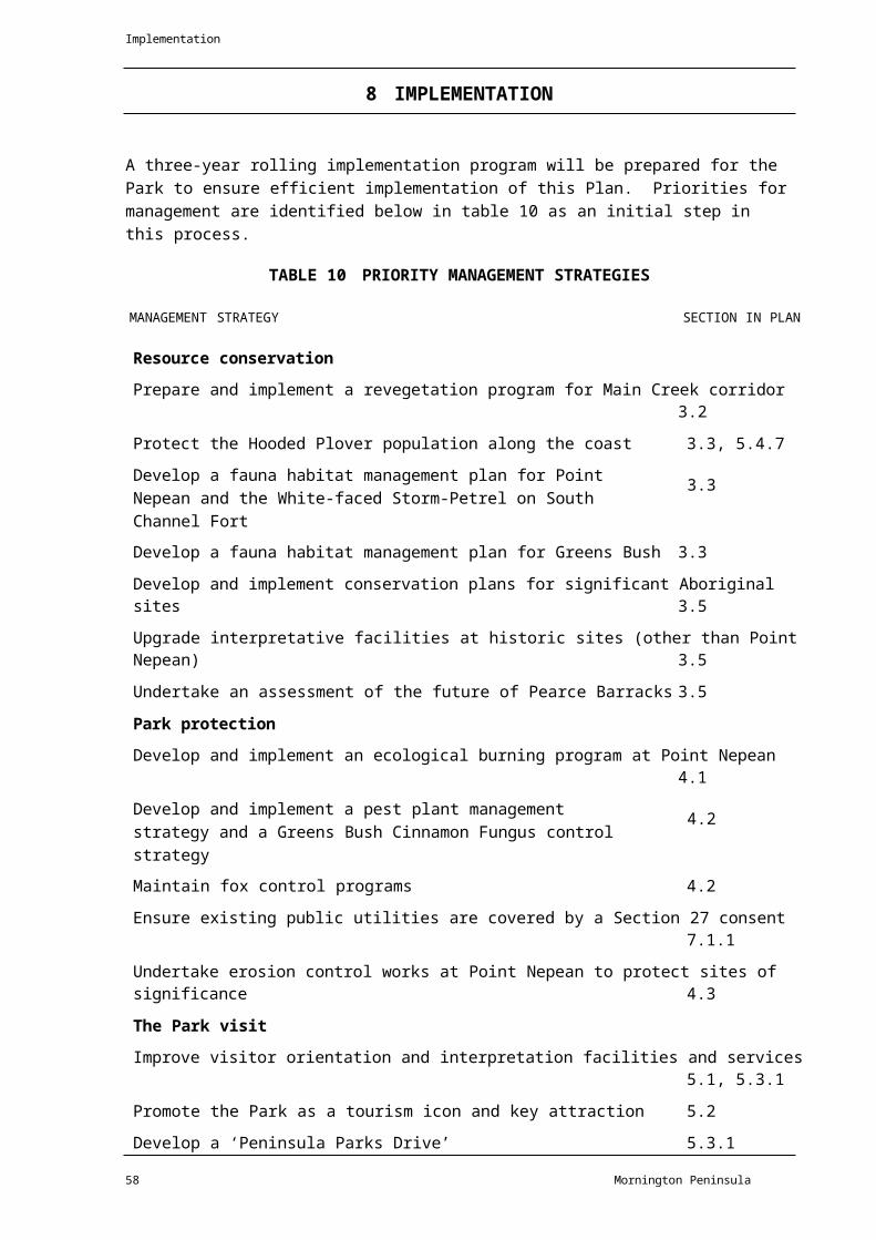
▼
D RIV
E
▼
O
P O R T P H I L L I P Dromana
B A YDromana Cemeter
y
HILLVIEW RESERVE
ROAD
McCrae ARTHURS SEAT
H llview
Quarry
P oneer
Quarry
Red Hill
O T Dam
Lookout Hill
T C McKELLAR CIRCUIT WALK
ROSEBUD PARK PUBLIC GOLF COURSE TRACK
Kings Falls
ELIZABETH
Mc Larens Dam
PUBLIC LAND USE
Other Reserves
Other Public Land
Shire Land
Major road
Minor road
Management vehicles and walkers only
ZONES
Conservation
Conservation and Recreation
Recreation Development
ARTHURS SEAT STATE PARK
Figure 4 MANAGEMENT ZONES AND PUBLIC LAND USE
Walking
track Gate
Park Boundary
OVERLAYS
Special Protection Area 250 0 250 500 750 1000
Cartography by Natural Resource Systems 98
Public Land Boundary
G/6524 4 Metres

▼
D RIV
E
▼
O
P O R T P H I L L I P Dromana
B A YDromana Cemetery
CHAIRLIFTHILLVIEW RESERVE
ROAD
McCrae
ARTHURS SEAT SUMMIT Hillview
Quarry
Pioneer Quarry
Red Hill
SEAWINDS GARDENS
O.T. DAM
O.T. Dam
Lookout Hi l
LOOKOUT HILL
T.C. McKELLAR
CIRCUIT WALK
CONCEPT SPUR
ROSEBUD PARK PUBLIC GOLF COURSE TRACK
Kings Falls
ELIZABETH
Mc Larens Dam
VISITOR INFORMATION FACILITIES
Major Tourist Centre(Includes Major Indoor Display and Primary Interpretation Centre Note : Location subject to a development plan)
Orientation Interpretation
Major outdoor sheltered display Primary
Information shelter Secondary
Signage map Tertiary
KINGS FALLS
Major road
Minor road
Management vehicles and walkers only
Walking track
Gate
EXISTING RECREATION SITES AND FACILITIES
Toilets Lookout
Kiosk Nature walk
Shelter Picnic table
Water Access for
Disabled BBQ
PROPOSED RECREATION SITES AND FACILITIES
Water Picnic table
Lookout BBQ
ARTHURS SEAT STATE PARK
Figure 5 ACCESS & RECREATION
MANAGEMENT
250 0 250 500 750 1000 Park Boundary Arthurs Seat State Park
Cartography by Natural Resource Systems 97Shelter Toilets

G/6524.5 Metres

Attachment 1
AMENDMENT TO THE MORNINGTON PENINSULA NATIONAL PARK AND ARTHURS SEAT STATE PARK MANAGEMENT PLAN 1998
AMENDMENT Section 5.4.11 Pages 48-49- replacement text for section:
Dogs
Many residents and visitors to the Park enjoy dog walking on the park's tracks and beaches
particularly in locations abutting residential areas. Dog walking is a traditional activity for some
residents and has occurred in the coastal areas of the Park for many years. Dog walking pre-dates
the area becoming a Park in 1975 under the provisions of the National Parks Act.
In 1998, on-leash dog walking was restricted to the early morning period from sunrise to 9.00 am in
designated sections of the coast in order to address impacts of dogs on park values and visitor
experiences. Dog walking continued to be prohibited in the Greens Bush, Highfield, Bushrangers Bay,
Cape Schanck and Fingal areas. Dog walking is not permitted in the abutting Point Nepean section,
now Point Nepean National Park or in the nearby Arthurs Seat State Park.
The Park is considered to be one of the highest priority habitats nationally for the Hooded Plover by
Birdlife Australia having the second highest adult population in Victoria but one of the lowest
breeding success rates across the state. The presence of dogs and particularly the problem of off
leash dogs are known to affect breeding success.
The dog regulations for the Park have remained essentially unchanged since 1998 other than
introduction of seasonal restrictions in 2009 on a section of Portsea Ocean Beach designated as a
shorebird protection zone.
Dog walking in the Park was reviewed with public consultation in 2012 to address a need to improve
the breeding success of shore birds particularly the threatened Hooded Plover, to enhance
protection of wildlife in general, to address the issue of non-compliance with the dog regulations
and to enhance the enjoyment of the Park by visitors other than dog owners.
Managing dogs to minimise impacts on the Hooded Plover may become more important if erosion
from natural coastal processes results in increased loss of breeding habitat. An adaptive approach to
managing dog walking needs to apply to ensure that the Park sustains its role as a key breeding
location for the Hooded Plover in Victoria.
There are extensive opportunities for dog walking on the Mornington Peninsula including local parks
and reserves and foreshore reserves on both Port Phillip and Western Port. The Mornington
Peninsula Shire provides designated off-leash areas where dogs can be exercised off-leash all year
round.
Assistance dogs for visitors with disabilities are allowed in parks where visitor access is allowed and
dog walking restrictions do not apply to assistance dogs.
Aim:
• Minimise the impact of dogs on park values and visitor experiences.
Page 1of 2

Management strategies:
• Permit on-leash dog walking during the sunrise to 9.00 am period in the designated visitor
sites and Park areas as shown in the table below and the attached map.
• Work with the local community to increase community understanding on the impacts that dogs can have and encourage involvement in managing dogs in the Park.
• Monitor the extent and suitability of Hooded Plover habitat annually. Should there be a
significant loss of key habitat as a consequence of coastal erosion develop and implement an
action plan to further restrict dogs in areas where dogs are permitted and Hooded Plover
nesting activity occurs.
• Monitor the impacts of dogs on natural, cultural and social values on an on-going basis and
undertake a further review of dog walking commencing in September 2015.
• Should monitoring show continued impacts on natural, cultural and social values or there
are on-going problems with non-compliance with the regulations, implement additional
restrictions or remove dog walking in the Park.
Designated Sunrise to 9.00 am on-leash Dog Walking Areas in Mornington Peninsula National Park
MAP REF. LOCATION CONDITIONSMap 1 Portsea Ocean Beach
Visitor SitePermitted in car parks, paths, beach access tracks and on asign-posted section of the beach
Map 2a&2b
Sorrento Ocean Beach to Orr Point, Rye (Brewster
Permitted in car parks, access roads, walking tracks and signposted beach and shoreline areas
Map 3 Rye Ocean Beach VisitorSite to St Andrews Beach
Permitted in car parks, paths, beach access tracks and a sign-posted section of the beach
Map4 Flinders Ocean Beach Permitted in car parks, beach access tracks and the shoreline between King Street and West Head. Not permitted in theMushroom Reef Marine Sanctuary.
AMENDMENT Page 29 Table 3 Summary of Recreation Activities
Table 3 is amended to provide for Dog Walking as YC (Conditional- refer to relevant section) in
management zones 2 and 3 (Conservation and Recreation Zone and the Recreation Development
Zone).
!Approved
Adam Fennessy
SECRETARYDEPARTMENT OF ENVIRONMENT AND PRIMARY INDUSTRIES
Date: 1.k I \ I 2013
Page 2 of2

WY
See
Map
2a
Map 1 – Portsea Ocean Beach Dog Walking AreaPoint Nepean National Park
Point NepeanQuarantine Station R
Mornington Peninsula National Park
P O R T S E A
London Bridge
London Bridge
Upper Car Park
B A S S S T R A I TPORTSEA OCEAN BEACH ACCESS LOWER RD
Dogs on leash only permitted from sunrise to 9.00am within hatched area on access roads, car parks, defined tracks and sign posted beach areas
Surf Life Saving Club
Lower Car Park
Portsea Ocean BeachMornington
Peninsula National Park
Sorrento Ocean Beach
0
50N
100Metres 200 Parking
Information Toilets
Picnic table
Lookout
Hang gliding ramp Gate

Main road Sealed road
Unsealed road
Walking track
Park/Reserve
P
a
rk
/
R
e
s
e
rv
e
b
o
u
n
d
a
ry
R
o
c
k
s/
R
e
ef
Beach
Dog
wal
kin
g
a
r
Dog
s
p
r
bite
d
www.parks.vic.
gov.au
e that this
all liability
may arise
r
informatio
Cartography by Parks Victoria May
2013For mobile App
search for Avenza PDF Maps

See
Map
2b
Map 2a – Sorrento Ocean Beach to Spray Point Dog Walking AreaPortsea
Mount Kerford50m
COPPINSTRK
Sphinx Rock
Sorrento Ocean Beach
Darby Rock
LIFESAVING TRK
S O R R E N T O
S u l l i v a n B a y
T h e S i s t e r s
P O R T
P H I L L I P
Mornington Peninsula National Park
Collins Settlement Historic Site
C a m e r o n B i g h t
St. Pauls BeachSt Pauls
Rock Jubilee
Point
D i a m o n d B a y
Diamond Bay
K o o n y a
Mt. St Paul
Dogs on leash only permitted from sunrise to 9.00am within hatched area on access roads, car parks, defined tracks and sign posted beach areas
Mornington Peninsula National Park
The Dogs Head
B L A I R G O W R I E
B A S S S T R A I T Koonya Ocean Beach
Spray Point
Pelly Point
Spray Point
Montforts BeachBridgewater Bay
0 125
N250
Me
tres
500
Parking
Information
Toilets
Picnic table
Electric
BBQ
Lookout
Lookout Gate
Main road Sealed road Unsealed road
Walking track

Park/Reserve Public land
Beach
Dog
walking
a
Dogs
p
r
d
www.parks.
vic.gov.au
Cartography by
Parks Victoria
May 2013
For mobile
App search
for Avenza
PDF Maps

See
Map
2a
Map 2b – Bridgewater Bay to Orr Point Dog Walking AreaSorrento
B L A I R G O W R I E
Koreen Point
B r i d g e w a t e r B a y
Bridgewater Bay
The Bridge
P i r a t e s B a y
Glenn Point
Pearces Beach
Dimmocks Beach
Dogs on leash only permitted from sunrise to 9.00am within hatched area on access roads, car parks, defined tracks and sign posted beach areas
Mornington Peninsula National Park
R Y E
B A S S S T R A I TThe Divide
Number Sixteen Beach
Orr PointRye
Parking Main road
Park/Reserve Dog walking area
www.parks.vic.gov.auDisclaimer: Parks Victoria does not guarantee that this data is without flaw of any kind and therefore
disclaims all liability which
0 150
N300
Metres
600
Lookout
Gate
Sealed road
Unsealed road
Walking track Beach

Dogs prohibited
may arise finformation.
Data
Cartography by Parks Victoria May 2013For mobile App seaPDF Maps

FOAM
ST
See
Map
2b
Map 3 – Rye Ocean Beach to St. Andrews Beach Dog Walking AreaOrr Point
R Y EMornington Peninsula National
Park
R y e O c e a n B e a c h
F I N G A L
Rye Ocean BeachMornington Peninsula National
Park
S T . A N D R E W S B E A C H
Dogs on leash only permitted from sunrise to 9.00am within hatched area on access roads, car parks, defined tracks and sign posted beach areas
S a i n t A n d r e w s B e a c h
St. Andrews Beach
B A S S S T R A I T
Mornington Peninsula National Park
Boag Rocks
C A P E S C H A N C K
Gunnamatta Surf BeachSurf Lifesaving Club
Cape Schanck
0 150
N300
Me
tres
600
Par
kin
g
Toilets
Picnic table Lookout Gate Main road
Sealed road
Unsealed
road
Walking track

Park/Reserve Beach Dog
walkin
g a
Dogs
p
r
ed
www.parks.vic.g
ov.au
Victoria does not guarantee
Data
Cartography by
Parks Victoria
May 2013
For mobile
App search
for Avenza
PDF Maps

N
Map 4 – Flinders Ocean Beach Dog Walking Area
F L I N D E R S Flinders Jetty
King Street
Mornington Peninsula National Park
Dogs on leash only permitted from sunrise to 9.00am within hatched area on access roads, car parks, defined tracks and sign posted beach areas
K e n n o n C o v e
Cape Schanck
Flinders Golf Course
Flinders Ocean Beach
The Blowhole
Mornington Peninsula National Park
Mornington Peninsula National Park
West HeadWest Head
Navy Gunnery
Mushroom Reef Marine Sanctuary
West Head
B A S S S T R A I T
0
100
N
200Metres
400
Parking Toilets
Picnic table
Lookout
Main road Sealed road Unsealed road
Walking track

Park/Reserve Public land
Beach
Marine
Park/San
ctuary
Rock/Ree
f
D
o
g
w
a
l
k
i
n
g
a
r
e
a
D
o
g
s
P
r
o
h
i
b
i
t
e
d
Note: Dogs not permit
tedin the Marine Sanctuary
www.parks.vic.
gov.auDisclaimer:
Parks
Victoria
does
not
guarantee
that
this
data
is
without
flaw
of
any
kind
and
therefore
disclaims
all
liability
which
may
arise
from
you
relying
on this information.
Data source acknowledg
ements: State
Digital Mapbase. The State
of Victoria and
Department of
Sustainability and
Environment.
Cartography by Parks Victoria May 2013
For mobile App search for Avenza PDF Maps