matamata-piako district heritage trail · 6 the gordon creamery was erected in 1897 and closed in...
TRANSCRIPT

HERITAGE TRAILMatamata-Piako District
Coulter Bridge, Te Aroha

Wairere FallsPhoto: Matamata-Piako District Council

The Matamata-Piako District Heritage Trail links the towns of Matamata, Te Aroha and Morrinsville and visits places of historical interest on the way. Separate brochures have
been prepared for trails in these three towns. A working party of a group of volunteers and Matamata-Piako District Council staff has prepared the trails over a period of years.
© Matamata-Piako District Council 2009Front cover photo: © Don Edwards, Photographer
Back cover photos: © Matamata-Piako District CouncilAll right reserved
Published by Matamata-Piako District CouncilPrinted by Tainui Press Design and Print, Matamata
ISBN 978-0-9597740-2-3
Compiled by Joan Stanley
HERITAGE TRAILMatamata-Piako District

This trail follows the Old Te Aroha Road under the Kaimai Range, which went from Te Aroha to Wairongomai in 1886, to service the gold miners and their families. Later the road extended to the Wairere Falls and the halfway house which catered for visitors to the area. The horse-drawn coach service carried on to Okauia, Te Poi, the Okoroire Hot Springs Hotel and Rotorua. This Heritage Trail circles around from Te Aroha to Okauia, then to Matamata
and Morrinsville and back to Te Aroha. There are several side trips on the route and places of historical interest are marked on the way. It can be accessed at any point along the trail.
Many sites are privately owned and the owner’s privacy should be respected.
This trail is 159.6km in length but as an alternative it can be followed for part of its length.
1
This 953m mountain, is the highest peak in the Kaimai range and a dominant feature of the town and the surrounding countryside. The major television transmitter on the summit is linked to the town by a winding road. There are bush tracks which give magnifi cent views of the countryside. These are accessed from the Te Aroha Domain.
According to one Maori legend, Te Mamoe, son of a Bay of Plenty Chief, climbed to the summit of the mountain,
and seeing landmarks of his tribal home said, “Aroha ki tai” “This mountain shall be called the Mountain of Aroha (Love)”. Later a stream of crystal water began to fl ow from the heart of the mountain and where it emerged hot springs with healing qualities appeared. A clear pool, known as the “Mirror of Te Mamoe”, became a wishing well for newly-married couples. Europeans sank a bore here and the resulting geyser of hot soda water, the only one of its kind in the world, was named the Mokena Geyser in honour of a Maori chief who once owned the land and was a generous and honoured friend of the pakeha.
Start of Matamata-Piako District Heritage Trail. Walk north a few metres along the footpath to the second site.
Mt Te Aroha
HERITAGE TRAILMatamata-Piako District

From Te Aroha follow the Old Te Aroha Road south along the foot of the Kaimai Range and turn left at Wairongomai Road. Continue to the end of road. (5.3km)
3
The Waiorongomai valley was mined for gold between 1880 and 1946. Throughout this period many different processes were tried to extract the ore but none proved successful.
In 1884, 3000 to 4000 people were living in Waiorongomai town which had a hall, 12 shops and three hotels. An old chimney standing in a paddock is all that remains today. A short distance upstream was the site of the fi rst main battery which Firth and Clark set up in 1882, but nothing remains of it today. The large concrete bins beside the car park were part of the Piako County Council metal crushing plant, which operated from 1920 to 1927, using some of the remaining mining equipment.
Along the stream and the bush-clad valley slopes, lies an extensive track network where the remains of tramlines, pack tracks, cart tracks, water races and other relics of gold mining days can still be seen. A series of interpretation panels on the track give a valuable insight into the natural and cultural history of this area. MPDC Heritage Site.
Site 3: Firth and Clarke Battery (centre) at Wairongomai, near the end of Loop Road. Fern Spar Incline at the left.Photo: Te Aroha Museum
Return to Old Te Aroha Road and turn left. Turn left again into Wairakau Road. (8.5km)
2in the Domain not built specifi cally for bathing purposes. Historic Places Trust Registration: Category II. Brochures available here for the Te Aroha Heritage Trail, the Matamata-Piako District Heritage Trail, the Te Aroha and District Museum, the Wairongomai Valley, Wairere Falls Scenic Reserve and the Arts Trail. Public toilets are located behind this building.
Sited on Whitaker Street, this building has information about all the events and places of interest in the Te Aroha district, it was originally the ticket offi ce for the Domain and later became doctors’ rooms. It was the fi rst building
Te Aroha i-SITE Visitor Centre
Waiorongomai Valley Mines

5
Thompson’s Track is an old formed county road which was once the main road linking the Katikati area with the Waikato. This old trail was developed as a road access across the ranges in 1885, to take local stock over the Kaimai Range to coastal sale yards before the Waihou sale yards, were developed. It is thought to have been named after Te Waharoa’s son, William Thompson (Wiremu Tamihana) the kingmaker and
Christian chief of the Ngati Haua. The road fell into disuse after the Kaimai Highway and Athenree Gorge roads were upgraded.
During the Second World War the Manawaru Home Guard dug trenches at the top of Thompson’s Track, ready to fi ght the Japanese had they invaded.
Today this 12km section of road through the Kaimai Mamaku Forest Park, is a narrow, muddy, unmetalled track, with frequent slips and washouts, but it is still frequently used by trail bikes, four wheel drive enthusiasts and horse riders.
Return to Old Te Aroha Road, turn left and continue along it to reach the site of the Gordon Creamery on the left. (9.3km)
Thompson’s Track
4
The Tuahu Track, like the Wairere and Te Tuhi Tracks, is an old Maori trail
crossing the Kaimai Range to the Katikati district. It was developed as a bridle and bullock track in the 1890s. It was used for tramping but is now maintained by the Department of Conservation and in 2007 was closed for logging.
Continue along Wairakau Road and turn right at the junction with Thompson’s Road. (1.5km)
Tuahu Track

6
The Gordon Creamery was erected in 1897 and closed in 1920. It was owned by the NZ Dairy Association and was worked by a four horsepower stationary steam engine. It was capable of treating
300 gallons of milk per hour. Every morning farmers brought their cans of milk in waggons to be processed. The cream was then sent in a waggon drawn by two horses along Wardville Road to Waharoa railway station, where it was consigned to the butter factory at Ngaruawahia in the Waikato and later to Frankton.
Site 6: Gordon Creamery. Photo: Morrinsville Historical Society
For a short side trip turn right into Armadale Road, then fi rst turn left into Tower Road. Stanley Landing site is on the left. (4.0km)
7
Josiah Firth’s Stanley Landing River Port, on the River Waihou, was opened in 1880. He cleared the river from Te Aroha up to his Matamata Estate. This allowed boats of shallow draft and barges to bring machinery, seeds and manure from Auckland and return with
wheat, chaff and other produce for the Auckland markets. It was in use until the railway came through from Morrinsville to Matamata in 1886. Stanley Landing was named to honour the famous African explorer H M Stanley.
Historic Place Trust: Category II; MPDC Heritage Site. (For further details see the Information Board).
Return along Tower Road, turn right into Armadale Road, then right into Old Te Aroha Road. The site of the school is on the right not far from the corner. (3.8km)
Gordon Creamery Site 1897-1920
Stanley Landing 1880-1886

9
A large plaque on a rock reads as follows:“Douglas DC-3 Skyliner ZK-AYZ ‘Hastings’ of New Zealand National Airways Corporation, crashed into the Kaimai Range 9km northeast from here on 3 July 1963, during a scheduled fl ight
from Auckland to Tauranga. This plaque placed here in memory of the three crew and twenty passengers who died on Flight 441.”
“At the time this was the worst aviation accident in New Zealand. Dedicated on 5 July 2003.”
The names of those who were killed are listed on the plaque.
Continue along Old Te Aroha Road to the rocks with a memorial plaque about the Kaimai Railway Tunnel collapse. The Memorial is in the layby on the left just before the railway overbridge. (1.4km )
Kaimai Air Crash Memorial
8
The Gordon School, originally named Armadale, was built in 1892 by Mr J Brooks. It is an interesting example of an early pre-fabricated design. It served not only as a school, but also as a centre for the Gordon district for social and church meetings. In 1946, after a new schoolroom was built, the original building was moved to the Selwyn
district near Te Poi. When this school closed in 1963, the old Gordon school was used as a hay barn until it was taken to the Firth Tower Museum, Matamata. The new school, left on this site when the school closed at the end of 1973, served as an offi ce for the New Zealand Forest Service (later the Department of Conservation) from 1979, until a year or two later when it moved to an adjacent section. The school building is now used as a Community Hall.
Continue along Old Te Aroha Road to the Kaimai Air Crash Memorial on the left. (0.5km)
Site 8: Gordon School. Photo: Matamata Historical Society
Gordon School

Site 10: Kaimai Tunnel. Photo: Matamata Historical Society
10
The two plaques on a rock read as follows:1. “On 24 February 1970 a collapse in
the Kaimai Tunnel claimed the lives of four men, Peter James Clarkson, Alfred Thomas Leighton, Donald Alexander McGregor, James Smart. This memorial is a tribute to them
and all those who worked to complete the tunnel.”
2. “The Kaimai Railway Tunnel, opened by the Prime Minister The Rt Hon R D Muldoon CH on 12 September 1978, constructed by the Ministry of Works and Development for the New Zealand Government Railway Department. Length: 8.856km Minimum diameter: 5.588m.”
A display about the Kaimai Tunnel is on show at the Firth Tower Museum.Continue along Old Te Aroha Road to see the site of the halfway house on the corner of Old Te Aroha Road and Goodwin Road. (3.7km)
11
In the late 1880s and 1890s, four-horse coaches travelling along the Old Te Aroha Road, would stop here at the Halfway House to have their horses changed on their way to Lichfi eld or Rotorua. Axel and Margaret Forsman lived here with their family of 13 children. They started farming in 1886 and also
operated the Halfway House. Margaret was an excellent cook and provided meals for travellers and sightseers. Two Forsman brothers were blacksmiths who attended to the horses. Members of the family acted as guides taking visitors to see the near-by Wairere Falls or to climb to the top of the Kaimai range. In 1982 the blacksmith’s forge and dairy, or cool store, were still standing, but later just the dairy remained.
For a short side trip drive to the end of Goodwin Road to the Wairere Falls carpark. (0.8km)
Kaimai Tunnel
Halfway House Site

13
Historic site 1843-1857
A Catholic Church was established by Father S M Seon near this site, once known as Waiapawa.”
In 1840 Bishop Pompalier travelled over the Wairere Track from Tauranga to visit
Matamata Pa. The next year the Bishop sent Father Seon to establish a Catholic mission station there. On 20 February 1843, a half acre of land at Okauia was purchased from the Maori owners for ₤1-5-0 (one pound fi ve shillings) and Father Seon transferred to a church built here. It was used by Catholic travellers as a stopping place between Tauranga and Te Awamutu.
Further along the Main Road on the left is the entrance to Te Tuhi Road. The Te Tuhi Track starts at the end of this road. (2.6km)
Catholic Mission Station Site
12
The Wairere Falls, with a 153m fall, are a distinctive feature of the Kaimai Range. The legend of Ngahue says that he came to New Zealand on the back of a fi sh and walked over the Wairere track from the other side. After travelling overland he brought back some greenstone and killed a moa at the foot of the falls before going back to his home in Rarotonga.
The Wairere Track links Matamata to the Bay of Plenty. It was a traditional route for Maori, used occasionally by
war parties and also to carry fl ax and pigs from the Waikato to Tauranga. Missionaries including Alfred Brown, William Williams and Thomas Chapman, and explorers and scientists such as Ferdinand Hochstetter (geologist), John Bidwill and William Colenso (botanists) also used the track. Lady Martin was carried on a litter and Celia Brown rode her pony over from Tauranga. Tarore, a young Maori girl, was murdered here in 1836. Today the track is used by sightseers and trampers. There is a spectacular view of the Waikato from the top of the falls.
Return along Godwin Road to the main Old Te Aroha Road and turn left. Look out for the small stone marker on the right hand side of the road, opposite Tills Road. (3.4km)
Wairere Falls
14
The Te Tuhi Track is an old Maori route across the Kaimai Range According to Maori tradition, the Te Tuhi Track was named after Te Tuhi (1823-1910), a prominent Maori chief of the Ngati Mahuta tribe of Waikato, a supporter of the Maori King movement in the 1850s. The Te Tuhi track was probably developed after the defeat of the Kingite forces in the Waikato in 1864, as a short
cut between the Piriakau at Whakamara and their Ngati Haua friends and family at Okauia and Tauranga.
After the establishment of a sawmill at Whakamaramara in 1912, the Te Tuhi Track was used frequently by the Okauia people who were working at the mill. In 1942, during the Second World War, the Army held jungle training exercises along the Te Tuhi Track. Trenches and fox holes made then, should not be mistaken for Maori fortifi cations.
Continue along the Old Te Aroha Road past the Okauia Springs Road turn-off to take a side trip to the Okauia Creamery site on the right. (1.5km)
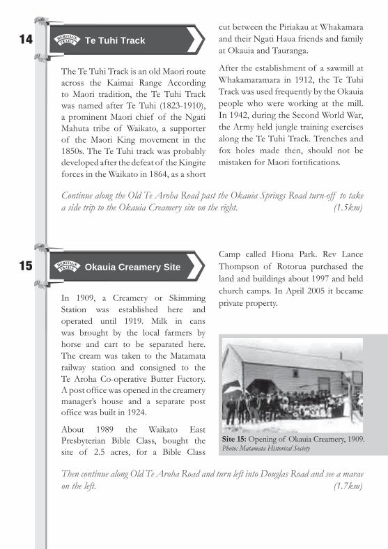
15
In 1909, a Creamery or Skimming Station was established here and operated until 1919. Milk in cans was brought by the local farmers by horse and cart to be separated here. The cream was taken to the Matamata railway station and consigned to the Te Aroha Co-operative Butter Factory. A post offi ce was opened in the creamery manager’s house and a separate post offi ce was built in 1924.
About 1989 the Waikato East Presbyterian Bible Class, bought the site of 2.5 acres, for a Bible Class
Then continue along Old Te Aroha Road and turn left into Douglas Road and see a marae on the left. (1.7km)
Camp called Hiona Park. Rev Lance Thompson of Rotorua purchased the land and buildings about 1997 and held church camps. In April 2005 it became private property.
Site 15: Opening of Okauia Creamery, 1909. Photo: Matamata Historical Society
Te Tuhi Track
Okauia Creamery Site

16
This marae is said to be the oldest marae in the Okauia area, but in 2006 it was unusable because of the state of the buildings. John Aoake, Chairperson of the Marae said, “The Ohaki Marae has
stood for more than a century and is a testimony to the tupuna who had the vision to establish, maintain and nurture the land, the buildings and the people.” Plans for the Marae include renovations to the whare tupuna, completing work already begun on the whare kai (kitchen), and the whare paku (toilets), and landscaping.
Continue along Douglas Road. The next marae is on the right. (0.2km)
17
The meeting house Hinerangi Tawhaki was built at Okauia by Tamatehura Rikihana for his family and opened in 1915. After his death, local elders wanted to move the meeting house to their own land, but needed the money to feed their families. In 1976 Russell Thomas, who owned the land, agreed that the Maori people could
move the meeting house, which had been used as a hay barn, back to their own land. Annie Marsh instigated the move and within a week the money had been raised.
The meeting house was moved down the road to Tawhaki Marae. More money was raised and by 1982 Hinerangi Tawhaki had been restored and renovated.
Drive to the end of Douglas Road. (1.1km)
Site 17: Hinerangi – Tawhaki Meeting House, 1976, with L-R Mrs Mary Douglas, Mr Walter Aoake and Mrs Annie Marsh. Photo: Ruth Cummins
Te Ohaki Marae
Hinerangi-Tawhaki Marae
Site 19: Okauia Primary School. Photo: Matamata Historical Society
18
The Douglas family farmed here after Korowhiti Tuataka Douglas claimed her ancestral lands in Okauia in 1894. Just before she died on 26 August 1920, she said,” “E ko ma hangaangia he whare mo koutou”. – “Don’t rely on other people, other building quarters. Build your own marae”.
A start was made under the leadership of Korowhiti’s two daughters Mary
Withers, (later Mrs Mack) and Sarah Jane Tanira. The menfolk began preparing the land for the marae, and money was put aside to pay for it.
In 1929, the carpenters started work and the completed meeting house was opened on 25 December 1930. First it was called the Douglas Marae and then, with the permission of Mrs Tanira, it was gazetted and called the Tangata Marae.
Return down Douglas Road and turn right into Old Te Aroha Road, going back to the Okauia Springs Road turnoff and turn left there. On the right is the Okauia Hall. (3.5km)
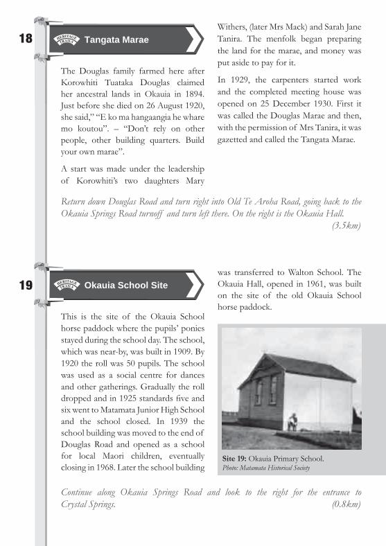
19
This is the site of the Okauia School horse paddock where the pupils’ ponies stayed during the school day. The school, which was near-by, was built in 1909. By 1920 the roll was 50 pupils. The school was used as a social centre for dances and other gatherings. Gradually the roll dropped and in 1925 standards fi ve and six went to Matamata Junior High School and the school closed. In 1939 the school building was moved to the end of Douglas Road and opened as a school for local Maori children, eventually closing in 1968. Later the school building
was transferred to Walton School. The Okauia Hall, opened in 1961, was built on the site of the old Okauia School horse paddock.
Continue along Okauia Springs Road and look to the right for the entrance to Crystal Springs. (0.8km)
Tangata Marae
Okauia School Site

Site 20: Crystal Springs. Photo: Matamata Historical Society
20
The Crystal Springs were opened by W Owen Garland about 1913. He developed swimming and bathing facilities in the hot pool as well as a bowling green and a camping ground. The Springs prospered with campers coming to stay for their holidays and it was popular for day visits to the attractive pool surrounded by native bush and ferns on the banks.
Disaster struck when amoebic meningitis affected several swimming patrons in 1969 and the swimming pool was closed. The owners then drilled for hot water and a new building was erected and opened in 1976 as the Moana-iti, a licensed restaurant, with an indoor
swimming pool. In 1979 the name was changed to Crystal Springs Park and Motor Inn. It is now privately owned by an organisation called YWAM (Youth With A Mission) Family Ministries NZ. See information Board at entrance.
Drive across the bridge over the Waihou River and look to the right half way up the hill. (0.5km)
21
According to Maori legend the private hot pool here was called Ramaroa, the name of the canoe that carried a Maori Chief and his wahine (wife) along the Waihou River. When they stopped to light a fi re at dusk, they turned to stone but the pool is always hot because of the perpetual fi re under the petrifi ed bow of their canoe.
About 1886, J C Firth put the land in his wife Anne’s name and the Springs
were developed as a place to visit for recreational purposes. It was purchased about 1900 by W J Aitken of Ngarua and his family, who owned the Opal Springs until 1975. The fi rst manager was Captain Henry Tizard, a well known fi gure, who built the fi rst of three concrete pools and developed a camping ground.
The Opal Springs have always been a popular place for day visits and for campers spending their holidays, many of them returning year after year.
Drive up the hill to see the Golf Course on the right. (0.4km)
Crystal Springs
Opal Springs

22
The Matamata Golf Course was owned by the Aitken family who obtained the site, together with the Opal Springs, from the Firth family about 1900. When the Matamata Golf Club took over the lease in 1935, it was covered with swamp and fern and infested with rabbits. Members cleaned it up and set up a nine-hole golf course on the right-hand side of the road with the assistance of Mr Redhead,
a Rotorua Golf Club architect. The fi rst clubhouse was built and the course was extended to 12 holes. By 1937 the full 18 holes were brought into play and the course expanded to an area on the other side of the road.
For many years sheep were grazed to keep the grass down on the fairways. The greens were fenced off and mowed and trees were planted. In 1955 the Club purchased the property from the Aitkens and in the 1960s the present clubhouse was built.
Continue to the T-junction, turn left into Tower Road and see the Tower on the left. (3.1km)
Matamata Golf Course
Site 21: Opal Springs. Photo: Matamata Historical Society

Site 23: Firth Homestead and Tower, 1884. Photo: Matamata Historical Society
23
The Firth Tower Museum was opened to the public in 1978. It was originally the site of the Matamata Estate homestead, with surrounding farm buildings. Firth Tower was built in 1881, and the present homestead was built in 1902 to replace the original house, which was destroyed by fi re. The Gordon School, mentioned earlier in this Trail, can be seen here as well as a display depicting the Kaimai Tunnel and many other interesting displays including examples of horse
drawn machinery. The Museum is set in pleasant grounds surrounded by shady trees.
Historic Places Trust: Firth Tower, Category I; McCaw Homestead, Church, Post Offi ce, School, Jail and Tamihana Monument, Category II. All these buildings plus the Settlers’ Cottage are on the Council List of Heritage Sites.
Public toilets here. For further details about the museum see the brochure available at the museum offi ce or at the Matamata i-SITE in the town of Matamata. (3.9km)
Continue down Tower Road to Matamata. Turn right at the roundabout and drive along Broadway to the Matamata i-SITE on the left just before the railway crossing. (3.7km)
Firth Tower Museum

24
This building was opened on 12 May 1988 as an information offi ce at the western end of Broadway. It has information about all the events and
places of interest in the Matamata district. Brochures are available about the Matamata-Piako District Heritage Trail, the Matamata Heritage Trail, the Firth Tower Museum, the Wairere Falls and the Arts Trail. Public toilets are located a short distance down Hetana Street.
Drive over the railway line, straight through the roundabout and along Peria Road, to the cemetery on the left. (2.0km)
25
The earliest burial record for this cemetery is 16 October 1910, six years
after the establishment of the Matamata township in 1904. Before that date burials were made at the Waharoa Cemetery or at Te Aroha. Burial records are available at Matamata District Council Area Offi ce, Tainui Street, Matamata.
Continue along Peria Road and turn left at the T-junction for a side visit. Look out for the small stone marker on the right hand side of the road at the top of the hill. (3.7km)
26
In 1846 Wiremu Tamihana moved his followers from Tapiri Village near the Matamata Pa on the Waitoa River, to this area in Peria. Here houses were
built, maize, wheat, potatoes, kumaras and peaches were grown, and a church, post offi ce and storage pits (rua) were built. Tamihana’s own homestead stood amongst the karaka trees which can still be seen to the right. Peria Pa is on the Council list of Heritage Sites.
Return down Peria Road and at the road junction keep straight on into Gunn Road and go up to the top of the hill to a carved stone on the right. (4.8km)
Matamata i-SITE Visitor Centre
Matamata Cemetery
Tamihana’s Peria Village site

27
In the 1850s and early 1860s the cultivated area of Tamihana’s Peria Village, extended from the hills down to the river Waitoa, where a boarding school was built. A fl our mill was also installed for which the
mill stones were brought up the River Waihou and carted to the Waitoa River to be used in the mill. Wheat was grown on the farms, ground at the mill and the fl our carted over a road to the Waihou River and sent to the Auckland markets. A large meeting house (Whare Runanga) was built here also. This site is also on the Council protected list.
Continue along Gunn Road and turn right into Landsdowne Road, right into Link Road, then left into State Highway 27. Cross the railway line. Turn right into Mowbray Road. The next site is on the right. (3.8km)
28
The Waharoa Hall was opened on 16 November 1916. It was built by W A Gordon of Matamata for ₤458 on a section donated by A J Tong.
The hall was used for regular picture shows, dances and private parties.
The picture theatre projectors from this hall are now housed at the Firth Tower Museum, although not as working exhibits.
Changes took place when use of the hall declined. The Trustees of the Public Hall could no longer meet the maintenance requirements so it was taken over by the Matamata County Council. The building is now in private hands.
Over the road on the corner of Mowbray Road and Ward Street, is the Waharoa Hall of Remembrance, which was offi cially opened on 23 January 1954. This hall has the Memorial Plaque of the First World War and the 1939-1945 Roll of Honour and is still used for meetings.
Continue along Mowbray Road to see the School House, now the Playcentre, on the left. (0.2km)
Site 27: Tamihana’s Meeting House. Photo: Auckland Museum
Tamihana’s School and Flour Mill Site
Waharoa Hall

Site 30: St David’s Church, Waharoa. Photo: David Stanley
30
Over 200 people witnessed the dedication of Waharoa Presbyterian Church on Sunday 18 October 1925. It was built on land given for that purpose by Mrs C Ross.
The church was built of hollow brick with a covering of plaster. It was built and furnished free of debt and was given the name of St David. Throughout the years Presbyterians, Anglicans and Methodists have worshipped there.
A bi-monthly service conducted by the Presbyterians is held now and the
Waharoa Friendship Centre meets there monthly. The 80th Jubilee of St David’s was held in October 2005. Annually at Christmas time the church is decorated and opened to the public.
Return back along Walker Street and turn into Ward Street. The school is on the left. (0.4km)
29
This fi rst school residence, provided for the head teacher of the Waharoa School in 1892, was built by builders Mitchell and Wratt. The design included an outbuilding with wash-house, toilet and
woodshed connected to the house with a covered way which was used as a tank stand. It was built next to the original school in Ward Street.
In 1974 this house was moved round the corner to Mowbray Road to serve as the Waharoa Playcentre. Matamata-Piako District Council Heritage site.
Turn left into Carroll Street and continue to the T-junction. Turn left into Walker Street and see the church on the right. (0.8km)
Waharoa Head Teacher’s Residence
St David’s Church

32
Across the railway line was the site of the original Waharoa cheese and butter factory built by J C Firth in 1886. It was the fi rst dairy factory in the district and was the forerunner of the successful dairy industry established here.
The railway had come through this district from Morrinsville in 1885/86 and a railway station was built and named Waharoa. Firth cut off a block of adjacent land and divided it into 50 acre sections suitable for dairying. He put aside land for a school, church, domain and shops as well as the dairy factory, which was the beginning of the township of Waharoa.
A creamery was built further west in 1901. Cream was separated from milk and sent by rail to Ngaruawahia.
In 1919 Firth’s original factory site came into the ownership of the New Zealand Co-operative Dairy Company. On 16 August 1920 the fi rst dried milk powder factory was opened by the Company. It was followed by a butter factory at the end of 1921. This was built further north. Cheese was manufactured in 1932 and again in 1942 when 2,005 tonnes was shipped to England in support of the war effort.
During the 1950s and 1960s the milk powder factory was said to be the largest in the southern hemisphere.
Although the butter factory was closed in 1991 the milk powder factory was not closed down until about four years later. The buildings were used for storage until they were demolished in 2005.
Open Country Cheese, a small, independent public company focused on producing premium quality cheese, was formed in 2001 and commenced
Waharoa
31
Waharoa School, consisting of one room, and originally called the Matamata School, was established in 1887 with a roll of 26 children. It was the fi rst school in the Matamata district and was attended by children from all over the district. The name was later changed to Waharoa School. Changes, additions and re-modelling have taken place
over the years, with trees being planted and removed. A school residence was built in 1892 and later moved around the corner into Mowbray Road. New classrooms were built in 1949, 1957 and 1965 and the original block was demolished when two more classrooms were opened in 1967.
The name has now been changed to Te Kura O Waharoa where lessons are taught in Maori.
Turn right into Mowbray Road again and right into Seddon Street (SH 27) to the rest area on the left. There are public toilets here. (0.5km)
Waharoa School

Site 33: Waharoa Butter Factory built 1921. Photo: Matamata Historical Society
33
In 2008 the Kaimai Cheese Company erected a building in the same style as the original Waharoa Butter Factory which was located directly across the railway line. The New Zealand Co-operative Dairy Company completed the original butter factory in December 1921. The next year it established a daily record of over 20 tons of butter which was a great feat in those days. At the time it was said to be the largest butter making factory in the world.
Over the years the machinery in the factory was modernised. Early wooden churns, which produced 5,712 tonnes of butter in 1948/49 season, were replaced by stainless steel churns, and in 1982 these were replaced with automatic continuous butter making machines producing 16 tonnes per hour or 50,000 tonnes per year. At the time it was the largest butter factory in the world.
In 1987 the Waharoa factory (including the milk powder department) employed 250 staff, produced 50,000 tonnes of butter, 30,000 tonnes of milk powder, and had an annual turnover of $150,000,000. However four years later in 1991 the butter factory was closed down.
Today at Kaimai Cheese visitors can view the cheese-making process through huge plate-glass windows in the café while sampling the variety of cheeses made there. These included camembert, creamy blue cheese and creamy brie as well as mature cheddar. For more details see the Information Board.
Cross the railway line and turn right into Dunlop Road. The cemetery is on the right hand side. (1.2km)
Waharoa Butter Factory
Site 32: Firth’s Butter and Cheese Factory at Waharoa built 1886. Photo: Matamata Historical Society
Drive north on Seddon Street and turn left into Hawes Street. The Kaimai Cheese building is on the left. (0.4km)
production in September 2004. Its Colby, Harvarti and Edam cheeses have scored some top prizes in the NZ Cheese Awards. They provide the home market and are exported overseas to Australia, Asia, Russia, the Middle East, the United Kingdom and Latin America. For more details see the Information Board.

34
The fi rst burial in this cemetery took place in 1879. It is now closed for burials. Records are kept at the Matamata offi ce of the Matamata-Piako District Council, Tainui Street, Matamata.
Almost directly opposite the cemetery is a stone marking the site of the Matamata Mission station. (0km)
35
In 1833 four Anglican missionaries from the Church Missionary Society, rowed up the Waihou River and walked through the swamps to the Matamata Pa to meet the Ngati Haua chief, Te Waharoa. They held the fi rst Christian service in the district outside their tents. Two years later Rev Alfred Brown,
followed by his wife Charlotte and their young son Marsh, came to Matamata to set up the fi rst mission station here. After 18 months the mission station had to be closed because of the escalating war situation with the Rotorua tribes. In 1838 Wiremu Tamihana established Tapiri, a Christian Village, near here. He built a large Raupo Church, 80 x 30ft for which Bishop Selwyn gave some glass windows in 1843.
A little further on the right. (0.1km)
36
This cemetery is still in use.
Continue along Dunlop Road until you reach another carved marker stone on the left. (0.9km)
Waharoa Cemetery
Matamata Mission Station Site
Waharoa Maori Cemetery
Site 37: Tarore’s Grave. Photo: Matamata Historical Society
Continue further along Dunlop Road and on the left is the next site.
38
The site of Kutia Pa is across the paddock between two totara trees. The local Hapu (sub-tribe) of Ngati Te Oro and Ngati Rangitawhake settled at Kutia Marae in the early 19th century. The Maori Parliament, “Te Kauhanganui”
or House of Assembly, was held here after it left Mangakawa, near Cambridge about 1898. The Parliament was later transferred to Rukumoana, near Kiwitahi, where it was opened in 1920. Because access to Kutia Marae was diffi cult, it was decided in 1924, to move to Raungaiti Marae, 1km to the east, where it was completed.
Return down Dunlop Road, turn left and then left again into State Highway 27. Continue north until a marae reached on the right. The Heritage Trail notice and numbers are on the left in a layby. (6.3km)
Kutia Marae Site
37
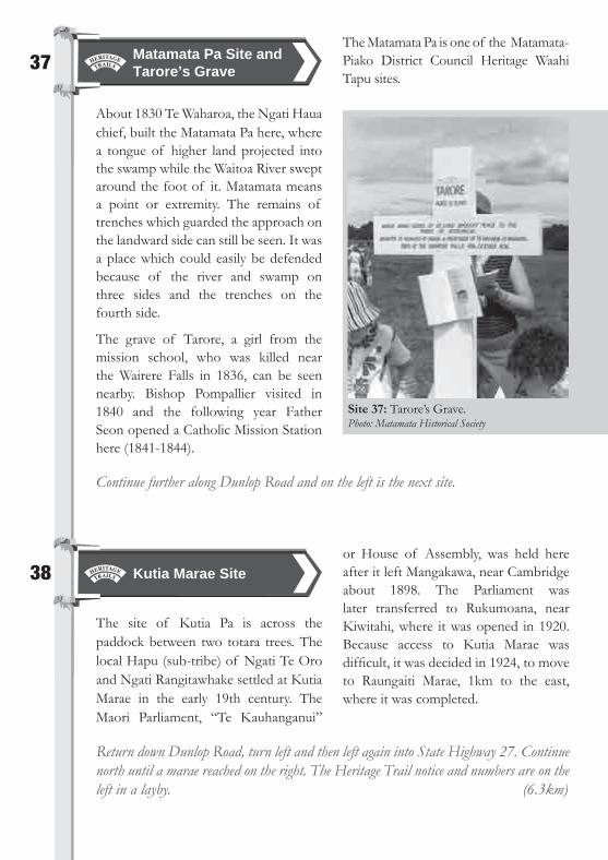
About 1830 Te Waharoa, the Ngati Haua chief, built the Matamata Pa here, where a tongue of higher land projected into the swamp while the Waitoa River swept around the foot of it. Matamata means a point or extremity. The remains of trenches which guarded the approach on the landward side can still be seen. It was a place which could easily be defended because of the river and swamp on three sides and the trenches on the fourth side.
The grave of Tarore, a girl from the mission school, who was killed near the Wairere Falls in 1836, can be seen nearby. Bishop Pompallier visited in 1840 and the following year Father Seon opened a Catholic Mission Station here (1841-1844).
The Matamata Pa is one of the Matamata-Piako District Council Heritage Waahi Tapu sites.
Matamata Pa Site and Tarore’s Grave
39
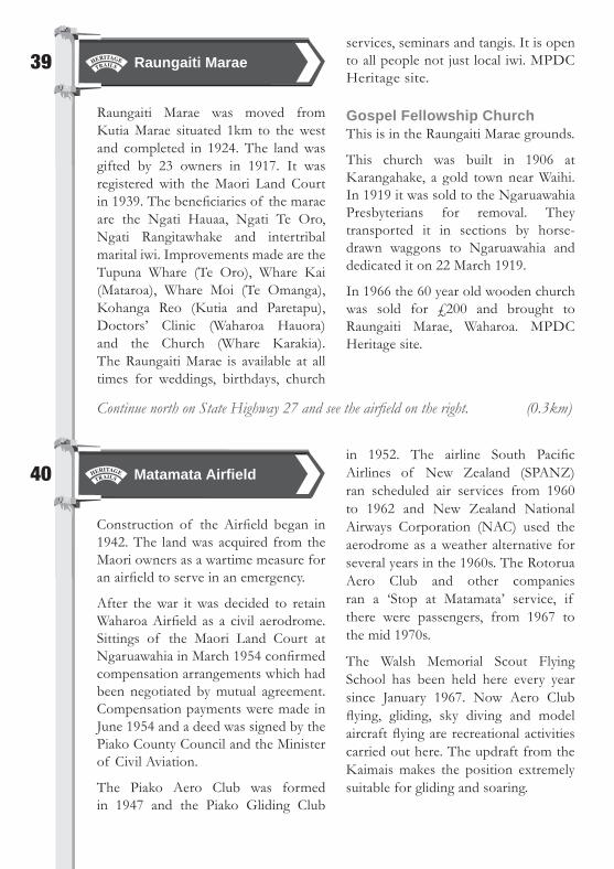
Raungaiti Marae was moved from Kutia Marae situated 1km to the west and completed in 1924. The land was gifted by 23 owners in 1917. It was registered with the Maori Land Court in 1939. The benefi ciaries of the marae are the Ngati Hauaa, Ngati Te Oro, Ngati Rangitawhake and intertribal marital iwi. Improvements made are the Tupuna Whare (Te Oro), Whare Kai (Mataroa), Whare Moi (Te Omanga), Kohanga Reo (Kutia and Paretapu), Doctors’ Clinic (Waharoa Hauora) and the Church (Whare Karakia). The Raungaiti Marae is available at all times for weddings, birthdays, church
services, seminars and tangis. It is open to all people not just local iwi. MPDC Heritage site.
Gospel Fellowship Church This is in the Raungaiti Marae grounds.
This church was built in 1906 at Karangahake, a gold town near Waihi. In 1919 it was sold to the Ngaruawahia Presbyterians for removal. They transported it in sections by horse-drawn waggons to Ngaruawahia and dedicated it on 22 March 1919.
In 1966 the 60 year old wooden church was sold for ₤200 and brought to Raungaiti Marae, Waharoa. MPDC Heritage site.
Continue north on State Highway 27 and see the airfi eld on the right. (0.3km)
Raungaiti Marae
40
Construction of the Airfi eld began in 1942. The land was acquired from the Maori owners as a wartime measure for an airfi eld to serve in an emergency.
After the war it was decided to retain Waharoa Airfi eld as a civil aerodrome. Sittings of the Maori Land Court at Ngaruawahia in March 1954 confi rmed compensation arrangements which had been negotiated by mutual agreement. Compensation payments were made in June 1954 and a deed was signed by the Piako County Council and the Minister of Civil Aviation.
The Piako Aero Club was formed in 1947 and the Piako Gliding Club
in 1952. The airline South Pacifi c Airlines of New Zealand (SPANZ) ran scheduled air services from 1960 to 1962 and New Zealand National Airways Corporation (NAC) used the aerodrome as a weather alternative for several years in the 1960s. The Rotorua Aero Club and other companies ran a ‘Stop at Matamata’ service, if there were passengers, from 1967 to the mid 1970s.
The Walsh Memorial Scout Flying School has been held here every year since January 1967. Now Aero Club fl ying, gliding, sky diving and model aircraft fl ying are recreational activities carried out here. The updraft from the Kaimais makes the position extremely suitable for gliding and soaring.
Matamata Airfi eld
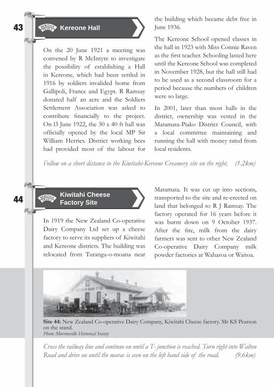
Site 42: The old Walton School. Photo: Walton School Board of Trustees
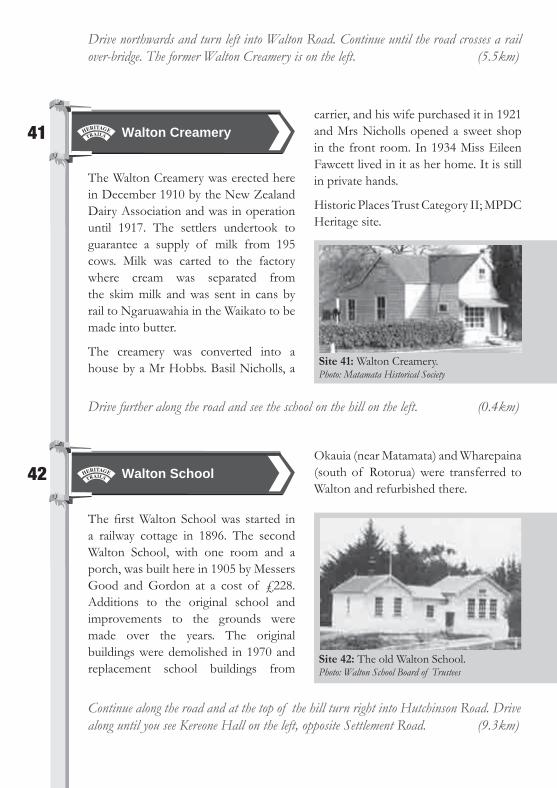
Site 41: Walton Creamery. Photo: Matamata Historical Society
Drive northwards and turn left into Walton Road. Continue until the road crosses a rail over-bridge. The former Walton Creamery is on the left. (5.5km)
41
The Walton Creamery was erected here in December 1910 by the New Zealand Dairy Association and was in operation until 1917. The settlers undertook to guarantee a supply of milk from 195 cows. Milk was carted to the factory where cream was separated from the skim milk and was sent in cans by rail to Ngaruawahia in the Waikato to be made into butter.
The creamery was converted into a house by a Mr Hobbs. Basil Nicholls, a
carrier, and his wife purchased it in 1921 and Mrs Nicholls opened a sweet shop in the front room. In 1934 Miss Eileen Fawcett lived in it as her home. It is still in private hands.
Historic Places Trust Category II; MPDC Heritage site.
Drive further along the road and see the school on the hill on the left. (0.4km)
Walton Creamery
42
The fi rst Walton School was started in a railway cottage in 1896. The second Walton School, with one room and a porch, was built here in 1905 by Messers Good and Gordon at a cost of ₤228. Additions to the original school and improvements to the grounds were made over the years. The original buildings were demolished in 1970 and replacement school buildings from
Okauia (near Matamata) and Wharepaina (south of Rotorua) were transferred to Walton and refurbished there.
Continue along the road and at the top of the hill turn right into Hutchinson Road. Drive along until you see Kereone Hall on the left, opposite Settlement Road. (9.3km)
Walton School
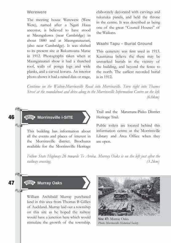
Site 44: New Zealand Co-operative Dairy Company, Kiwitahi Cheese factory. Mr KS Pearson on the stand.Photo: Morrinsville Historical Society
43
On the 20 June 1921 a meeting was convened by R McIntyre to investigate the possibility of establishing a Hall in Kereone, which had been settled in 1916 by soldiers invalided home from Gallipoli, France and Egypt. R Ramsay donated half an acre and the Soldiers Settlement Association was asked to contribute fi nancially to the project. On l3 June 1922, the 30 x 40 ft hall was offi cially opened by the local MP Sir William Herries. District working bees had provided most of the labour for
the building which became debt free in June 1936.
The Kereone School opened classes in the hall in 1923 with Miss Connie Raven as the fi rst teacher. Schooling lasted here until the Kereone School was completed in November 1928, but the hall still had to be used as a second classroom for a period because the numbers of children were so large.
In 2001, later than most halls in the district, ownership was vested in the Matamata-Piako District Council, with a local committee maintaining and running the hall with money rated from local residents.
Follow on a short distance to the Kiwitahi-Kereone Creamery site on the right. (1.2km)
Kereone Hall
44
In 1919 the New Zealand Co-operative Dairy Company Ltd set up a cheese factory to serve its suppliers of Kiwitahi and Kereone districts. The building was relocated from Turanga-o-moana near
Matamata. It was cut up into sections, transported to the site and re-erected on land that belonged to R J Ramsay. The factory operated for 16 years before it was burnt down on 9 October 1937. After the fi re, milk from the dairy farmers was sent to other New Zealand Co-operative Dairy Company milk powder factories at Waharoa or Waitoa.
Cross the railway line and continue on until a T- junction is reached. Turn right into Walton Road and drive on until the marae is seen on the left hand side of the road. (9.6km)
Kiwitahi Cheese Factory Site

45
In earlier times Maori homes were built as near as possible to the Topehahae Stream, but as the land surrounding these homes was low-lying and subject to fl ooding, it was often necessary to wade through a lake to reach the access tracks. The name Rukumoana meant “swimming or wading through a lake”. The fi rst marae site is believed to have been on high ground near Tahuroa Road traffi c bridge, but because of these diffi culties of access during fl oods it was moved to its present site.
Te Kauhanganui, Parliament Building
This building was erected in 1917. It was recently renovated at a cost of $400,000 and offi cially re-opened in 2006.
Tawhiao, the second Maori King, established the fi rst Te Kauhanganui, a House of Assembly, at Maungakawa, near Cambridge in 1891. By the early 1900s another was built at Kutia, near Waharoa on present day Dunlop Rd.
The present building at Rukumoana Marae was offi cially opened on 14 September 1917. It was used for the meetings of the Maori parliament from then until the 1940s. The minute books of proceedings are held in the archives inside the building. It is hoped that eventually the archives will be open to the public. Ngati Haua Iwi are the guardians of Te Kauhanganui
Historic Places Trust Category I; MPDC Heritage site.
King Mahuta Monument
This statue was unveiled on the afternoon of Wednesday 12 September 1917. There was a large assemblage of 2000 Maori and Europeans present, including many dignitaries.
The monument is on a pedestal 10ft high on a concrete base with a solid block of granite at the bottom. The inscription reads “He kohatu whakamaharatanga tenei mo Kiingi Mahuta, Tawhiao, Potatau, Te Wherowhero”. Mahuta’s whakapapa to the seven main canoes is depicted on the sides of the base. J Bouskill was the stonemason.
Major restoration work was undertaken under the supervision of Ian Grant of the Ministry of Works in 1984. The statue was removed for repairs and then reinstated.
Historic Places Trust Category 1; MPDC Heritage Sites.
For photo of Te Kauhanganui see back cover.
Te Paki 0 Matariki
The house Te Paki o Matariki was opened on 22 April 1945 and was in use in 1955 by a religious group, the Brethren, for services. A P Godber of Silverstream carved the fi gure at the base of the poutokomanawa, proposed the stencils for the rafter patterns and had a great deal to do with the general design of the building The name is that of the newspaper printed during the 1890s on the press at Maungakawa, and the name of the Kingitanga coat of arms – (Te Paki o Matariki – The Girdle of the Pleiades).
Rukumoana Marae
Werewere
The meeting house Werewere (Were Were), named after a Ngati Haua ancestor, is believed to have stood at Maungakawa (near Cambridge) in about 1880 and at Maungatatautari, (also near Cambridge). It was shifted to its present site at Rukumoana Marae in 1912. Photographs taken when at Maungatautari show it had a thatched roof, walls of ponga logs and wide planks, and a carved koruru. An interior photo shows it had a raised dais or stage,
elaborately decorated with carvings and tukutuku panels, and held the throne in the centre. It was described as being one of the great “Council Houses” of the Waikato.
Waahi Tapu – Burial Ground
This cemetery was fi rst used in 1913. Kaumatua believe the there may be unmarked burials in the vicinity of the building, and beyond the fence to the north. The earliest recorded burial is in 1912.
Continue on the Walton-Morrinsville Road into Morrinsville. Turn right into Thames Street at the roundabout and drive along to the Morrinsville Information Centre on the left. (6.0km)
46
This building has information about all the events and places of interest in the Morrinsville district. Brochures available for the Morrinsville Heritage
Trail and the Matamata-Piako District Heritage Trail.
Public toilets are located behind this information centre at the Morrinsville Library and Area Offi ce when they are open.
Follow State Highway 26 towards Te Aroha. Murray Oaks is on the left just after the railway crossing. (3.2km)
Morrinsville i-SITE
47
William Archibald Murray purchased land in this area from Thomas B Gillies of Auckland. Murray laid out a township on this site as he hoped the railway would have a junction here which would stimulate the growth of the township.
Murray Oaks
Site 47: Murray Oaks. Photo: Morrinsville Historical Society

Continue towards Te Aroha until you see Tatua Dairy Co Factory on the right. (3.5kms)
It was not to be, the main reason being that the junction was sited at Morrinsville and not Murray Oaks, and Thomas Morrin was a Director of the Railway Company while William Murray was not.
With the opening of the Morrinsville to Te Aroha rail line on 8 March 1886, a passenger platform was established at Murray Oaks. A shelter shed was erected in 1887 and in May 1890 W S Allen was
allowed to build sheep pens and a loading race here. Eight years later stockyards were built with Allen and the Railway Department sharing costs. December 1912 saw a change of name to Piako Station. By 1948 the station ceased to be a stopping place for passenger traffi c. The station building was removed in December 1961 and Piako Station was closed to all traffi c. The stock yards were removed in 1968.
48
Under the guidance of William Milliken, who was to become the fi rst Chairman of Directors, a group of settlers met to form the Tatua Dairy Company and build a cheese factory. A tender was called and the factory was built and equipped, and opened on 21 October 1914. There were ten suppliers when the factory opened. Tatua did not join with others to form the New Zealand Co-operative Dairy Company in 1919 but remained independent. In 1924 the factory was extended to cater for the increased milk supply from the 88 shareholders and extended again in 1929. Plans to rebuild were delayed until after the Second World War. The old building remained to manufacture casein for 20 years.
Late in 1946 the last cheese was made and a new concrete building was used as a milk powder plant. In 1953 tanker collection changed the way milk was collected. A new casein factory was built in 1964 and the concrete building housed the milk powder driers. Research was done and in 1975 the company started experimenting with putting cream into an aerosol can and producing Dairy Whip.
A rebuilding programme was begun in 1983 and by 1992 they had a modern factory building which included another spray drying plant.
In 2008 the Tatua Co-operative Dairy Company specialises in the development and marketing of innovative dairy products. It is one of the few remaining independent dairy companies in New Zealand that has not been part of an amalgamation or take-over.
Continue towards Te Aroha until the Waitoa Dairy Co can be seen on the left and you reach a layby on the same side. (4.7km)
Tatua Dairy Factory
49
This Information Board has many interesting details about the history of Waitoa, its Dairy Factory and School.
Waitoa District Historical Board
50
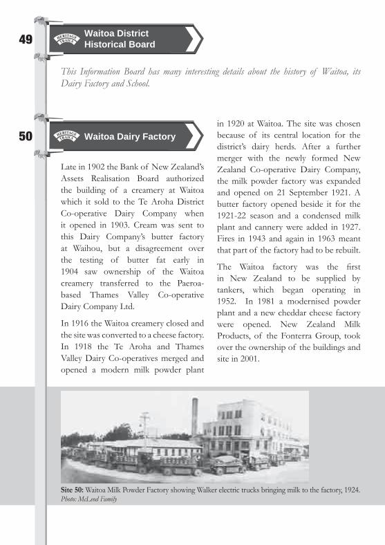
Late in 1902 the Bank of New Zealand’s Assets Realisation Board authorized the building of a creamery at Waitoa which it sold to the Te Aroha District Co-operative Dairy Company when it opened in 1903. Cream was sent to this Dairy Company’s butter factory at Waihou, but a disagreement over the testing of butter fat early in 1904 saw ownership of the Waitoa creamery transferred to the Paeroa-based Thames Valley Co-operative Dairy Company Ltd.
In 1916 the Waitoa creamery closed and the site was converted to a cheese factory. In 1918 the Te Aroha and Thames Valley Dairy Co-operatives merged and opened a modern milk powder plant
in 1920 at Waitoa. The site was chosen because of its central location for the district’s dairy herds. After a further merger with the newly formed New Zealand Co-operative Dairy Company, the milk powder factory was expanded and opened on 21 September 1921. A butter factory opened beside it for the 1921-22 season and a condensed milk plant and cannery were added in 1927. Fires in 1943 and again in 1963 meant that part of the factory had to be rebuilt.
The Waitoa factory was the fi rst in New Zealand to be supplied by tankers, which began operating in 1952. In 1981 a modernised powder plant and a new cheddar cheese factory were opened. New Zealand Milk Products, of the Fonterra Group, took over the ownership of the buildings and site in 2001.
Waitoa Dairy Factory
Site 50: Waitoa Milk Powder Factory showing Walker electric trucks bringing milk to the factory, 1924. Photo: McLeod Family

Site 51: Waitoa School offi cial opening, 1904. Photo: Te Aroha Museum
51
The Waitoa Valley School opened on 1 July 1904 on a site on the main road opposite the dairy factory. In 1923 the fi rst classes were held in the new school
rooms on this site in Ngarua Road. In 1968 a fi re destroyed the old block and new buildings were erected. In 1997 the Waitoa School Historical Society moved the original 1904 school building on to the present site and restored it for use as a community museum.
Continue along State Highway 26. For a side trip turn left into Thomas Road. Follow this until it becomes Eastport Road and continue along it. A plaque on the left, in front of the Eastport Playcentre marks the site of the former church. (9.0km)
Waitoa School
52
The Eastport Road Methodist Church was opened on 21 August 1910, partly funded by community donations. Rev A J Reed opened the church, which seated 60. This church was the only social centre of the surrounding farming
community and concerts were held here. The vestry was added in 1917 and the Sunday School Hall in 1941. Regular use of the church declined except for the annual Christmas evening service. In 2005 it became the property of the Elstow Playschool. In 2007 the church building was transported to Te Poi and a plaque was erected to commemorate its history.
Eastport Road Church Site
Return to the main road, turn left and see the Red Star Service Station building on the right. (8.5km)
Drive out of the layby and continue left towards Te Aroha until you reach Ngarua Road on the right. Just past this turn-off the Waitoa School can be seen on the right. (0.9km)

Site 53: Red Star Service Station (Russell’s Garage). Photo: Russell Family Collection
53
In 1893 James Buchan and his son George purchased a blacksmith’s business from John Jones. In 1906 he sold this to Leonard Roberts and based a coach building fi rm beside the smithy in partnership with Cyril Booker. They sold out to Hamilton coach building fi rm Pomeroys in 1918. Pomeroys made the transition to servicing the emerging motor trade until the company sold up at Waihou in 1928. Their automotive business was continued in 1930 when Charlie Russell opened a garage in one part of the building, which became
the Red Star Service Station. Other businesses said to have been based here for a time were Blacksmith James Dixon, Mr Pearson who started a business repairing and building radios and Nancy Gibson who had a sewing business here as well as a shoe repairer.
Three generations of the Russell and Borrie families served the community at Russell’s Red Star Service Station until 2001 when the garage closed. The building briefl y reopened as Red Star Relics and Antiques, owned by Craig Thompson. It later became a business selling car parts.
Historic Places Trust Category II; MPDC Heritage site
Turn left into Ngutumunga Road and drive along until you reach the former Waihou School buildings. (0.4km)
Red Star Service Station (Russell’s Garage)
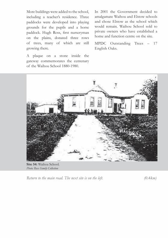
54
The Waihou School was fi rst opened in 1880 in the fi rst Public Hall built on a site in 2nd Avenue. In April 1895 the
pupils and teachers moved to the new school on this site of eight acres. This was purchased by the community from Esther Swney and the Education Board fi nanced the school. It consisted of one room and a porch and was built by William Stoup at a cost of ₤289.
Waihou School
Site 54: Waihoa School. Photo: Ross Family Collection
Return to the main road. The next site is on the left. (0.4km)
More buildings were added to the school, including a teacher’s residence. Three paddocks were developed into playing grounds for the pupils and a horse paddock. Hugh Ross, fi rst nurseryman on the plains, donated three rows of trees, many of which are still growing there.
A plaque on a stone inside the gateway commemorates the centenary of the Waihou School 1880-1980.
In 2001 the Government decided to amalgamate Waihou and Elstow schools and chose Elstow as the school which would remain. Waihou School sold to private owners who have established a home and function centre on the site.
MPDC Outstanding Trees – 17 English Oaks.
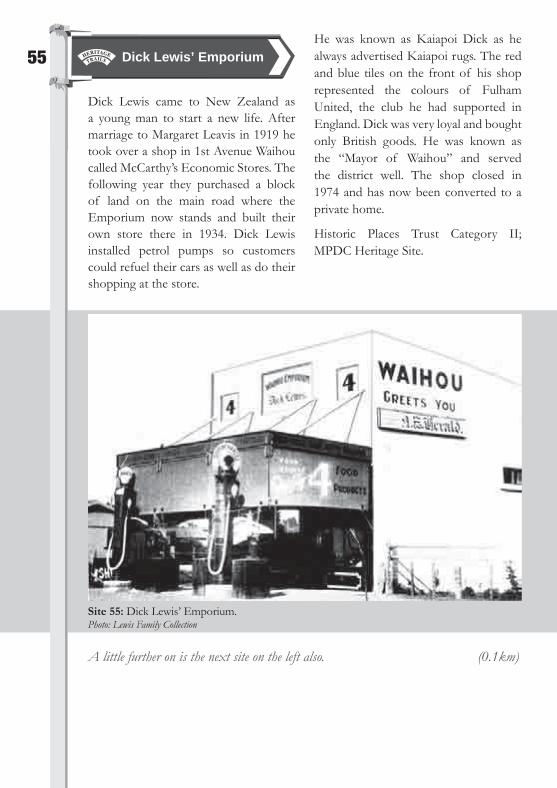
Site 55: Dick Lewis’ Emporium. Photo: Lewis Family Collection
55
Dick Lewis came to New Zealand as a young man to start a new life. After marriage to Margaret Leavis in 1919 he took over a shop in 1st Avenue Waihou called McCarthy’s Economic Stores. The following year they purchased a block of land on the main road where the Emporium now stands and built their own store there in 1934. Dick Lewis installed petrol pumps so customers could refuel their cars as well as do their shopping at the store.
He was known as Kaiapoi Dick as he always advertised Kaiapoi rugs. The red and blue tiles on the front of his shop represented the colours of Fulham United, the club he had supported in England. Dick was very loyal and bought only British goods. He was known as the “Mayor of Waihou” and served the district well. The shop closed in 1974 and has now been converted to a private home.
Historic Places Trust Category II; MPDC Heritage Site.
A little further on is the next site on the left also. (0.1km)
Dick Lewis’ Emporium

Site 56: Waihou Post Offi ce.Photo: Ross Family Collection
56
The Waihou Post Offi ce was gazetted on 1 April 1880, with Thomas Rowe as the fi rst postmaster in his store and butchery. The post and telegraph business was transferred to a store run by Edwin Graham and John Bealby Smith in 1884.
The fi rst post offi ce was opened in this building on 16 November 1912, built at
a cost of ₤971. It used only three date stamps over its 108 years. In 1912 the Postmistress was Mrs C F Black, followed by Mrs E Mackenzie, Mrs E E Adams, Mrs A P Warner, Mr Kay, Mr Excell, Miss Natalie Excell, Mrs Sanna Donelly and Waihou’s last Postmistress Mrs Gwen Stewart. Following Government restructuring of postal services in the 1980s, Waihou’s old Post Offi ce closed on 5 February 1988 and has now been converted to a private home.
Turn right into 2nd Avenue. The church is on the left. (0.1km)
Waihou Post Offi ce

Follow the main road to Te Aroha until the bridge is reached.
Site 57: Waihou Historical Pioneer Church. The opening by Sir Charles Ferguson.Photo: Ross Family Collection
57
In 1879 this was the site of a locally funded public hall and used as a school, a church and a community building, erected on land donated by Hugh and James Palmer Campbell. In 1895 the pupils and teachers moved to a school erected on a new site.
With the building of a new Public Hall in 1914 on another site, the old hall became redundant. When the Te Aroha Anglicans completed their new enlarged church in the 1920s, Hugh Ross, Waihou’s nurseryman, purchased the original St Mark’s Anglican Church at Te Aroha.
The solid kauri building was transported to Waihou in sections and re-erected on the old hall site in 1926. Elizabeth Allen Ross donated a bell for the church in memory of her son Hugh, who had been killed in World War I. Memorial plaques honour the fallen in both world wars as well as the founding trustees of the church. In its early years at Waihou the church served the Anglican, Presbyterian, Seventh Day Adventist and Associated Churches of Christ denominations.
In 1999 restoration commenced under the Historic Places supervision and it now is used for many weddings.
Historic Places Trust Category II; MPDC Heritage Site. See information board inside the church gates for full details.
Waihou Historic Pioneer Church

58
On a fi ne day this bridge, which makes a dramatic entry to Te Aroha, has a lovely view of Mount Te Aroha. It was constructed in 1928 and is known as Coulter Bridge, in honour of Robert Coulter, Mayor of Te Aroha, 1921-1941. It was made of reinforced concrete.
The fenced footpath on the northern side is an original feature and is matched by one on the other side, constructed at a later date. The tall lights are a modern addition while the shorter ones are original.
The Te Aroha Clock Tower can be seen at the end of the street and the television transmitting tower can be seen on the top of Mount Te Aroha.
Continue over the bridge and turn left just before the town clock. Drive along and turn right into Russell Avenue, left into East Avenue and right into Hamilton Street, going right to the end where the site is on the right.
Coulter Bridge
Site 58: Coulter’s Bridge.Photo: Te Aroha Museum
59
This historic Generator was built here in 1906 to provide the Te Aroha Borough with electricity. Te Aroha Borough was the fi rst local body in the Thames Valley to have electricity. This fi rst electricity
scheme, which relied on water power, became known as the No 1 generator. It provided electricity between sunset and midnight. The wheel has been restored and is placed at its original location in Hamilton Street.
For full details see Information Board at the site.
Te Aroha Power Station Site
Return to the Te Aroha i-SITE via East Avenue and Russell Avenue. Then turn left into Whitaker Street. Follow this road until you arrive at the Te Aroha Domain and i-SITE, where the trail begins.

References for further information
Allen, S S. Early MorrinsvilleDavison, G. Waharoa School – Celebrating 100 Years 1887-1987Duxfi eld, S et al. Historic Matamata, 1983Gordon, Mona. Golden Age of Josiah Clifton Firth, 1963Harris, C T. Diamond Jubilee of the Piako CountySettlement and development of the Upper Thames Valley, 1877-1937Kellaway, L and W. Kauhanganui Parliament Building.Conservation and MaintenancePlan for Rukumoana Marae February 2004 draftKingsley-Smith, C. This is Te Aroha – 1880-1980McDonald, C. Gordon District 85th and School 75th Jubilee, 1969McDonald, C. Waharoa School and Township 75th Jubilee – 1887-1962 McLoughlin, T and G Davison. Gordon Centenary – 1884-1984 Murray, J. Walton School 100 – 1896-1996 Rickard, L S. Tamihana, The Kingmaker, 1963Sing, C K. Tatanui – A History of the District and School – 1908-1994Stanley, J et al. Matamata Looking Back, 1994 Stone, R C J. Makers of Fortune, 1973Stott, Bob. Kaimai – The story of the Kaimai Tunnel, 1978 Tatua Co-operative Dairy Company Ltd75 Years of Independent Progress 1914-1989Vennell, C W and D More. Land of the Three Rivers, 1976Vennell, C W et al. History of the Matamata Plains – 1771-1950, 1951Waihou School Jubilee, 1955Waihou School Centenary 1880-1980Waitoa School Centennial 1904-2004 – Celebrating 100 Years of School and DistrictWaitoa School. Photos collected for the 100th Jubilee March 2004Waitoa School Centennial 1904-2004 – Celebrating 100 Years of School and District, 2004Walton School 1896-1971 – History of the Walton School and DistrictWaugh, R J. Kaimai Crash New Zealand’s Worst Internal Air Disaster, 2003Wells K. The Noble Aroha. Te Aroha MountainCelebrating Te Aroha 125 years (1880-2005)Wild, F W. Te Aroha and The Fortunate ValleyPioneering in the Thames Valley 1867-1930, 1930

MATAMATA-PIAKO DISTRICT COUNCIL35 Kenrick Street, Te ArohaPO Box 266, Te Aroha 3342P 07 884 0060 or freephone 0800 746 467F 07 884 8865E [email protected]
MATAMATA i-SITE45 Broadway, Matamata 3400P 07 888 7260F 07 888 5653E [email protected]
MORRINSVILLE i-SITE251 Thames Street, Morrinsville PO Box 40, Morrinsville 3340P/F 07 889 5575E [email protected]
TE AROHA i-SITE102 Whitaker Street, Te Aroha 3320P 07 884 8052F 07 884 8259E [email protected]
MPDC acknowledges fi nancial assistance from the Lottery Grants Board and Trust Waikato and photographs and information from Morrinsville Historical Society, Matamata Historical Society Inc and the Te Aroha and Districts Museum. Information in this brochure is presented in good faith. The researcher /author was Joan Stanley. While every care has been taken in its preparation, MPDC accepts no responsibility for its accuracy.

Matamata plains and Kaimai RangePhoto: David Stanley

ISBN 978-0-9597740-2-3
Te Kaungahanui, RukumoanaFirth Tower, Matamata