mapping complex decision making in critical geographies – identifying approaches and establishing...
TRANSCRIPT

Mapping complex decision making in critical geographies – Identifying approaches and
establishing partnerships in the Indus Basin
Kathmandu Workshop 16th February 2016
ICIMOD HQ

I. Background
• SAWGP supporting work on Indus Basin– Informing Change in the Indus Basin
• Six components: Knowledge (1), Analysis (2) and Dialogue (3)– Purpose of this meeting is to support development of
component 2a on ‘Mapping Complex Decision Making in Critical Geographies’• Your input to the process, engagement in a partnership of
individuals and institutions to help design and deliver• Addressing a key question: How to strengthen decision
making and build a more inclusive decision support environment using GIS in the Upper Indus Basin?
II. Upper Indus Decision-Making Environments: What are the
fragilities and what options are there to tackle them?
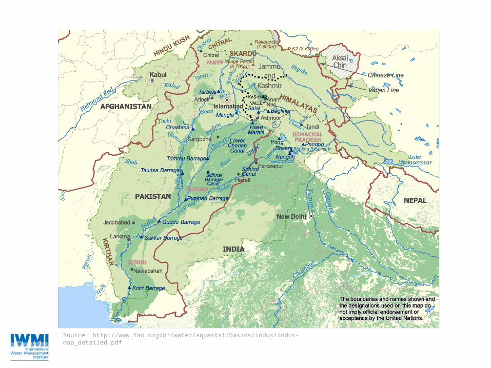
Source: http://www.fao.org/nr/water/aquastat/basins/indus/indus-map_detailed.pdf

Key challenges driving ‘fragilities’• Natural-systemic
– Relationship between ‘reservoirs’ (upstream/downstream)– Nature of variability and uncertainty – including changing land use and
climate change shifting seasonal timing/shuffling geographical distribution of supplies• Complex change to glaciers as natural storage reservoirs, providing
perennial supplies• Human-systemic
– Demand on resources for hydropower development– ‘Dependence’ on water (c.300 million…but key differences between)
Knowledge gaps and lack of consolidation – sub-optimal decisions– Challenge of becoming a ‘closed’ basin (implications for ecosystems)– Need for better connection between upstream assessments (supply) and
downstream demand, including ag production (93% of withdrawals)– Fragmented institutions and decision making, contested geographies– No basin-wide institution

Uncertainty Certainty
Upstream
Downstream
Rising demand in agriculture
Future flow regime control
structures
Changing glacier /
snowmelt
Knowledge Gaps
Knowledge Gaps
Population growth
Water quality issues
Institutional fragment.

Critical questions to pose• What is the significance of climate change as a cause of variability and uncertainty in
basin flow dynamics and what are future changes likely to being in 5, 10, 20, 50 years?
• How far are future changes likely to be outside recent extremes? What is the order of magnitude of populations at risk? How will the frequency and magnitude of extreme events such as floods and droughts in the Indus Basin change in the future?
• How will future water demand and availability and access scenarios in the Indus Basin change as a result of climatic and socioeconomic shifts?
• What information related to glaciers/snowmelt (that we don’t already have) is critical for the improvement of understanding of water resource dynamics in the Indus Basin?
• How can we make future responses to challenges more sensitive to local needs and be more equitable (including aspects of gender equality)?
• What low/no regrets options are there for adaptation to future scenarios in the Indus Basin?
III. The objectives of this meeting
• To build an analytical model that overlays multiple data sets and provides a useful decision support function at different scales
• To establish a partnership with ICIMOD and other institutions to take forward its development
• (This meeting)– A design protocol (what is it that we are trying to do and
how)– Partners and timeline (at least until end 2017…)– Outputs and working arrangements (key milestones)

Tentative timeline
• Jan-Mar: Start up preparation of preliminary data and mapping package
• Apr-Sep: Develop prototype tool• Oct-Dec: Engage with important stakeholders• 2017: – (early) pilot tool within decision making
environments at different scales– Build feedback loops for refining and adjusting
What kind of decision support?
• Enabling shared understanding with transparency of design that enables stakeholder engagement
• Seeking optimal solutions to management,• What level of sophistication:– ‘…a framework linking a database and processing
environment, knowledge and information system, modeling and analysis framework, socio-economic framework and a communication framework’ (GWP, 2013)

Challenges
• Data availability, quality and consistency• Volume of data now potentially available (how
to manage in a cost-effective manner / vfm)• Building a robust user interface (who are
they?)• Scale and breadth versus granularity and
depth (balance)• Data permissions and sharing

Examples of DSS• RIBASIM http://www.wldelft.nl/soft/ribasim/int/index.html • WEAP http://www.weap21.org/ • MIKE BASIN http://www.dhisoftware.com/mikebasin/Description/• MODSIM http://modsim.engr.colostate.edu/ • WBalMo http://www.wasy.de/english/produkte/wbalmo/index.html • Decision Support Framework (DSF) for the Lower Mekong Basin• Nile Basin DSS• DSS including hydro-economic modeling for the Euphrates-Tigris region• Zambezi River Basin • Multi-Sector Investment Opportunities Analysis (MSIOA), a DSS
including hydro-economic modeling in the Rio Grande basin• Okavango River Basin Decision Support System

The Nile DSS

The Mekong


IV. Working Group Questions
Breakouts:• Four working groups (‘1,2,3,4’) each tackle four core
questions (need to ensure group balance)1. What are the ‘hotspot challenges’ the GIS tool should
respond to (define 4-5 critical issues in the UIB)2. Who would be the potential user groups?3. What functionality would make the tool practical and useful?4. What should be key next steps in development?
• Report back with short PowerPoint slides (one per question/set of answers)