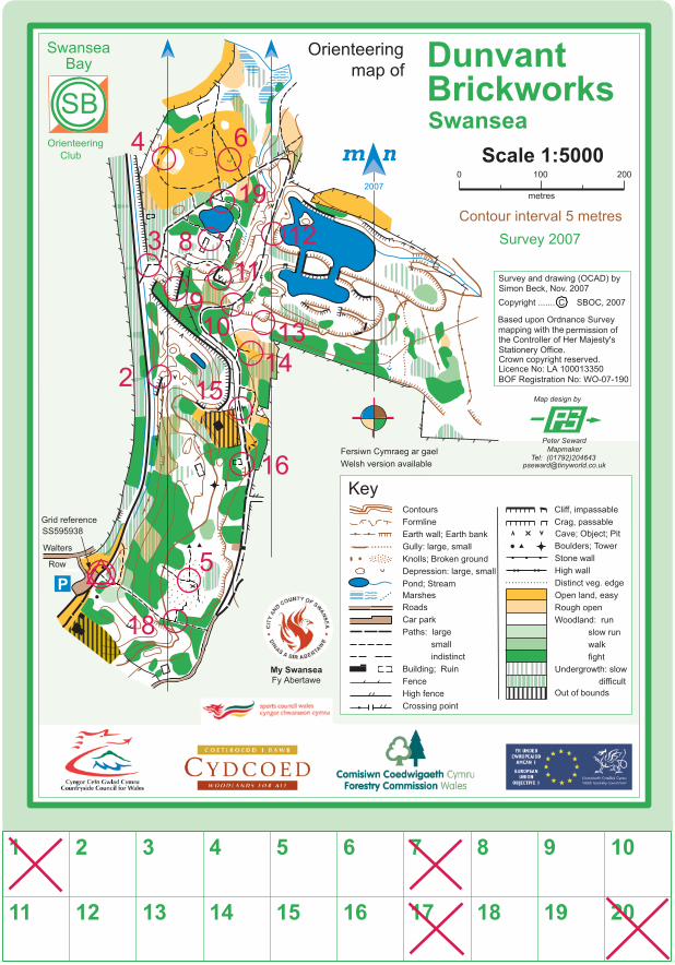
map of dunvant brickworks orienteering course
DESCRIPTION
Detailed map and instructions for Dunvant Brickworks orienteering courseTRANSCRIPT
Orienteering at Dunvant Brickworks
AIM. The aim in orienteering is to get around a course, made up of a series of control points, by working out a route between them from the map and then map-reading your way along the
route and finding the controls.
THE MAP. This is a standard orienteering map; the symbols and colours are explained in the legend. The scale is 1:5,000 which means that 1cm on the map represents 50m on the ground, as
shown by the scale line.
DISTANCES. The distance from one point to another can be worked out using the scale line on the map. When measuring on the ground, a metre is roughly one man-sized stride.
DIRECTIONS. Whichever direction you are going or facing, keep the map the same way round as the ground, i.e. orientated. When you go forward, features to one side on the map will be on
the same side on the ground.
THE COMPASS. If you have one you can use it to orientate the map. The needle points to magnetic north. Use this to keep the north arrows on the map pointing north too. Also, the compass
is especially useful for finding accurate directions across areas without paths, and to sort out which way to go at path junctions, etc.
How to use a baseplate compass for directions:
1. Place the edge of the compass's baseplate along the direction you want to go on the map. 2. Turn the capsule so that the parallel lines in it are in line with the north lines on the map. 3. Take the compass off the map and hold it in front of you, pointing forward. TURN YOURSELF with the compass until the needle is in line with the lines in the capsule. 4. Travel forward in the direction the front of the compass is now pointing.
CONTROLS and MARKERS. The locations of the controls are shown on the map by numbered circles in red, and a description of each is given below. The controls are marked on the ground
by a post on top of which is a plaque with a red and white orienteering symbol. There is a number, which corresponds to the same control on the map, and a letter which you note down in the appropriate square on the control card at the side of your map to confirm your visit.
CONTROL DESCRIPTIONS:
Start 2. 3. 4.
Crag, NE end, foot Bridge Vegetation boundary
5. 6. 8. 9.
Path junction Pit Ruin, NE corner Crag foot
10. 11. 12. 13. 14.
Path junction Cave entrance Earthbank, top Earthbank, top Path end
15. 16. 18. 19.
Gate Ruin, SE corner Path junction Path junction
SUGGESTED COURSES. Starting and finishing from the car park and recycling centre off Walter Row in Dunvant, and is shown on the map with a red triangle on top of a double circle:
White 1.7Km short and easy for young novices: Start - 3 - 8 - 19 - 12 - 10 - 15 - 18 - Finish
Yellow 1.7Km easy for older beginners and progressing from White: Start - 18 - 16 - 14 - 12 - 19 - 11 - 3 - Finish
Orange 2.1Km harder for progression from Yellow: Start - 2 - 9 - 11 - 8 - 4 - 6 - 12 - 13 - 16 - 5 - Finish
OR see how many controls you can visit in a set time, say 30 or 45 minutes (a ‘Score’ event).
FURTHER ORIENTEERING OPPORTUNITIES. If you would like to do more orienteering contact the local club, SWANSEA BAY ORIENTEERING CLUB, by visiting the club's website at www.sboc.org.uk
ACKNOWLEDGEMENTS. This permanent orienteering course was set up with the help of grants channelled through City and County of Swansea from ‘Climbing Higher’ (Sports Council for Wales), Cydcoed (Forestry Commission), Countryside Council for Wales and European Union Objective 1. The map was made by, and the courses planned by, Swansea Bay Orienteering Club.