mangrove distribution in northwestern australia in relationship to regional and local freshwater...
TRANSCRIPT

Mangrove distribution in Northwestern Australia in relationship to regional and local freshwater seepage
V. Semeniuk* 21 Glenmere Road, Warwick W.A. 6024, Australia
Keywords : B iogeograph ic region, F re shwa te r seepage, G r o u n d w a t e r salinity, Manga l , Mangrove , T ida l flat
hyd ro logy
Abstract
The reg iona l d i s t r ibu t ion of mangrove species a long the t rop ica l N W coast of Aus t r a l i a is closely re la ted to c l imate . In s u b h u m i d regions with ra infa l l >1 000 m m / y r manga l s have 12 species which are recur r ing and c o m m o n . The c l imate becomes more ar id sou thwards and species r ichness decreases: 8 species are c o m m o n in manga l s in semia r id regions and 5 species are c o m m o n in ar id regions. Ra in fa l l inf luences the d i s t r i bu t ion of species across t ida l flats because of direct recharge to g r o u n d w a t e r systems and also because of subsurface seepage a long the h in te r l and edge. M u c h of the increase in species divers i ty is loca ted a long high par t s of t idal flats and a long the edge of the h in ter land.
At the local level s t r a t i g r aphy forms an i m p o r t a n t pa r t of the h y d r o l o g y by de t e rmin ing the d i s t r ibu t ion of aqui fe rs and aquac ludes . F re sh wa te r seeps in to the t ida l lands via bur ied , d iscrete aquifers and di lutes the h ighly hypersa l ine g roundwa te r . M a n g r o v e s inhab i t these local a reas above the less saline g roundwate r . The inf luence of ra infa l l and f reshwater seepage on mangals is presented as a unifying theme which helps to expla in d i s t r ibu t ion and divers i ty of mangroves at bo th a regional and local level.
Introduct ion
On a wor ldwide basis the d i s t r ibu t ion , d ivers i ty and zona t ion of mangroves (mangals ) has been des- c r ibed by numerous au thors ( M a c N a e , 1968; Walsh , 1974; C h a p m a n , 1976) and it is well k n o w n tha t the
* Acknowledgements: Sections of the data for this study were collected during research funded by Amax Exploration Pty. Ltd. (Port Warrender and Mitchell River estuary) and Wood- side Petroleum Pty. Ltd. (Dampier Archipelago, 1978). Prelimi- nary data from Fitzroy River estuary were collected while the author held a Queen's Post-doctoral Fellowship in Marine Science at the University of Western Australia. Data from all other study sites were collected by the author at various times between 1973 and 1981. G. Marston assisted with field work. T. Farrell collected water samples from Port Warrender in May, 1981. Dampier Salt Ltd. provided access to portions of the Maitland River delta through their leased area. The manuscript was reviewed by P. N. Chalmer, R. G. Brown, and P. G. Wilson.
Vegetatio 53, 11-31 (1983). © Dr W. Junk Publishers, The Hague. Printed in The Netherlands.
mos t diverse manga l s o c c u r in the humid t rooics with ra infa l l > 2 000 r a m / y e a r . In ar id regions salt f lats and salt marshes deve lop at l a n d w a r d edges of manga l s and replace mangroves . There is also a progress ive decrease in species divers i ty as a r id i ty increases.
Sal t f iats are highly hypersa l ine env i ronments and the excessive sa l in i ty is toxic to mangroves ( M a c N a e , 1968; C la rke & H a n n o n , 1970; Chap- man, 1976; C in t r6n et al., 1978). In fact, as this p a p e r shows, the ex t reme l a n d w a r d po r t i on of salt f iats may develop g roundwa te r and soi lwater salini- ty in excess of 240%0. Pa t chy or local ised mangals in such env i ronments provide sites of na tu ra l exper- iments and thus p rov ide useful da t a on what con- t ro is mangrove deve lopmen t in high t idal habi ta ts . A d i lu t ion in hypersa l in i ty a l lows g rowth of man- groves on these flats, and in ex t reme l andward par ts of t ida l flats, fresh water is the cause of this di lut ion.

12
MacNae (1968) noted rainfall as an important factor controlling variation of the idealised mangal zonation. He considered zonation was complete only where freshwater input f rom rain or rivers was greater than loss through evaporation and transpi- ration. Walsh (1974) also identified surface fresh water f rom uplands and rainfall as important fac- tors in producing a balance between the salinity and nutrient concentrations, both of which affect man- gals.
To date emphasis has been placed on recharge of surface fresh water in mangrove environments. However, an important factor in mangal develop- ment is the subsurface seepage whereby saline groundwater is diluted under tidal flats. Direct re- charge by rainfall and surface fresh water flowing onto tidal lands obviously also is important and should not be discounted. Such recharge however may be only a short-term event. Subterranean seepage on the other hand may be a eontinuous
event which occurs throughout the wet and dry seasons of a given region as a consequence of the local stratigraphy; it is potentially a major pheno- menon.
It is instructive to view such seepage regionally, and NW Australia offers an appropriate setting as mangrove coastlines span 3 climatic zones and mangals can be viewed from one extreme where freshwater seepage is large and widespread, to the other where it is regionally insignificant but locally important because of sparse seepage points.
Various factors play a role in developing seepage points on tidal flats; these include: 1) type of hinter- land (rocky terrain, sand plain or alluvial deposits), 2) physiographic relief of hinterland, 3) type of hinterland/tidal flat contact (flat, steep, or with cliffs), and 4) aquifer characteristics of the hinter- land/t idal flat. However, the main theme explored in this paper is the effect of freshwater seepage on mangals, regardless of the mechanism of how it has
.... I1" INSET B
INSET D
) .... "lll~ !1 D~B~ j I ""°°"E INSET C
RONSARD ISLAND
KERAUDREN HEDLAND
DAMPER
ROEBUCK BAY
WESTERN A U S T R A L I A
D .s,3o.
[~2"
~TH
DAMPIER ARCHIPELAGO " ~ o
0
D A M P I ~ % ~ v _..% G ' ~ C~"SSAC K
KARRATHA
RIVER DELTA ~ . ~ ,,6~, \ \ .7.
Fig. 1. Map showing study area between Exmouth Gulf and Port Warrender and location of study sites. Solid circles on inset maps shows location of tidal flat transects at the study sites.

13
invaded tidal environments. The first part of the paper examines distribution
and diversity of mangrove species and modification of mangals relative to regional climate. Later, se- lected areas are examined where there is variation of mangal in response to variation in local strati- graphy and fresh water. The conclusions of this paper rest on integrating 1) data on mangrove di- versity across the climate gradient, 2) published climatic data, 3) distribution of species on tidal flats, 4) stratigraphic profiles across.hinterland and tidal flats and 5) groundwater and soilwater ana- lyses.
Methods
A wide variety of mangals was studied at numer-
ous sites in NW Australia (Fig. 1). At each site mangals, tidal zones and adjoining physiographic units were mapped using aerial photographs. Tran- sects (generally 2-4 per study area) were established to sample vegetation, groundwater, soils and strati- graphy. Zonation and diversity of vegetation were documented by 1) belt transects perpendicular to the shore through the mangal, 2) lengthy (>10 km) traverses along the hinterland edge, 3) aerial photo- graphs, and 4) reconnaissance checks at all sites of various habitats and phototones as deduced from aerial photographs. Species abundance was esti- mated using the following categories: a b u n d a n t (or, at least common); present ; u n c o m m o n ; and rare.
Groundwater and soilwater samples were col- lected in specific tidal flat and floral zones (Fig. 2). Groundwater (from the phreatic zone; Todd, 1959)
L~ .J
2 , . > , ~ J O - I
w ~
WUjz~
z=:j~ wo~
o ~- u u )
MANGAL FLAT SALT FLAT
M.S.L. M.H.W.N.
SEAWARD ASSEMBL- ZONE OF AGES OF RhizophorG 4vicennio • ;onnerotlo
M.H.W.S.
LANDWARD SALT FLAT ZONE (BARE OFMANGROVES)
IHINTERLAND ; MAY BE ROCKY
\TERRAIN, DUNES H / LAklf~SANDPLAIN OF MAR'~'I'I~ '~IMESTONE
L I -SUPRATI DA L
E.HWS.
Z uJ ABSENCE OF
.J Z MANGROVES
Rh.Z. L .Z . SALT FLAT H/LAND OR
H.E HINTERLAND
ID k.Z. SEAWARD LANDWARD MID h.Z PORTION OF PORTION OF
SALT FLAT SALT FLAT 'BOUNDARY"BOUNDARY' 'MID SALT FLAT' MID H.E
Fig. 2. Schematic profile of tidal flat in NW Austral ia showing: 1) relationship of the wedge of muddy tidal flat sediment to the hinterland, 2) geomorphic and mangrove zone terms used in this paper, 3) their relationship to tidal levels, and 4) collecting sites for groundwater and soilwater in relationship to geomorphic and mangrove zones. Asterisk indicates that a particular zone may be absent.

14
was collected f rom auger holes and pits. Surface soil samples for pellicular and interstitial soilwater were hermetically sealed and frozen for storage; soilwater was later extracted for salinity analysis. To ensure the salinity was at a max imum value prior to dilution by spring tide, samples were col- lected during the later part of the neap period. Samples were collected during the latest part of the dry season for most localities so that salinity was unaffected by any recent rainfall. In some areas
samples were also collected during the wet season and spring tides to document rainfall and tidal re- charge. All water samples were analysed for total dissolved solids by conductivity and /or evapora- tion after filtering to remove all solids ~0.45/~m.
Soils and stratigraphy were described in terms of structure (layering, burrows, roots, peds, desicca- tion cracks and vesicular gas bubbles), texture (grain size and sorting), grain composition, colour and induration.
A eononnuo,
350
C Mean maximum temperature in summer (January,*C)
E o g o Mean annual rainfall from f~c.,p~% tropical cyclones (mm) ~.;oo
~ 100
B Mean annual evaporation (mm) ~ _ /
D Mean minimum temperature _~.r~. in winter ( duly, C ) ~ \ " "]~--
F I ~ A ~ , o ,v, on0,ove b,oo.oro0.,c
regions I- liT ~ ~ ' : ~
llI ~ .~.......'..!'.......:~-...,:.....'.<,:!.:.....:. i !: ! i i ! ? i i l ~~..".."-."..".."..".."..".':i"..." o,
Fig. 3. A-E show contoured maps of climate elements viz. rainfall, pan evaporation and temperature; maps A D after Bureau of Meteorology (1973-76); map E is after Milton (1978). F) Distribution of climate zones referred to in this paper, and distribution along the coast of mangrove biogeographic regions I, 11 and III, after Semeniuk et al., 1978.

Regional climatic effects
Climate
Northwestern Australia has a tropical climate N of Exmouth Gulf (Gentilli, 1972). Rainfall, evapo- ration, temperature and the occurrence of the wet season progressively change from north to south (Bureau of Meteorology (1973a, 1975, 1976, Fig. 3)), with annual rainfall showing the most marked variation. Rainfall is seasonal with a short wet summer season (3-4 months), often accompanied by cyclonic depressions (Milton, 1978), and a dry winter season.
The study area spans 3 broad climatic zones with- in the tropical region (Fig. 3F; Trewartha, 1968): 1) Tropical subhumid (Awg of KSppen, 1936), 2) Tropical semiarid (Bswg), 3) Tropical arid (Bwh and Bssh). Climatic data for each study site show that the climate zones have characteristic rainfall and evaporation parameters. Subhumid areas have large rainfall (>1000 mm/yr), an evaporation/ rainfall ratio of 1.8-2.5, and a large number of raindays per year (>90). Semiarid areas have 469-621 mm/yr rainfall, an evaporation/rainfall ratio of 5.4-6.8, and some 32 to 47 raindays. Arid areas have 267-360 mm/yr rainfall, and evapora- tion/rainfall ratio in excess of 10, and 16-33 rain- days.
Table 1. Mangrove species occurring in Western Australia.
*Acanthus ebracteatus Vahl, Acanthaceae Aegialitis annulata R.Br., Plumbaginaceae Aegiceras corniculatum (L.) Blanco, Mysinaceae Avicennia marina (Forsk.) Vierh., Verbenaceae
*Avicennia eucalyptifolia Zipp. ex Mig., Verbenaceae Bruguiera exaristata Ding Hou, Rhizophoraceae Bruguiera parviflora (Roxb.) Wight & Arn. ex Griff Rhizo-
phoraceae Camptostemon schultzii Mast., Bombacaceae Ceriops tagal (Perr.) C.B. Rob., Rhizophoraceae Excoecaria agallocha L., Euphorbiaceae Lumnitzera racemosa Willd., Combretaceae Osbornia octodonta F. Muell., Myrtaceae Pemphis acidula J.R. & G. Forst., Lythraceae Rhizophora stylosa Griff., Rhizophoraceae Scyphiphora hydrophylacea Gaertn., Rubiaceae Sonneratia alba Sm., Sonneratiaceae Xylocarpus australasicus Ridley, Meliaceae
* These species occur in Cambridge Gulf, outside the study area defined in Figure 1, and are excluded from this paper
15
Regional dis tr ibut ion o f mangroves in relationship to cl imate
Reg iona l dis tr ibut ion and zonat ion o f mangrove species
Seventeen species of mangrove have been re- corded in W Australia (Table 1, and Semeniuk et al., 1978) however, only 15 species occur in the study area and are directly relevant to this paper. A further 2 species (Scyphiphora hydrophylacea and P e m ph i s acidula) are rare in the study area and were not encountered at the 21 study sites.
The most diverse mangals occur in subhumid biogeographic region 1 (Fig. 3F). Here 12 (rarely 15) species occur on tidal fiats (Figs. 4 & 5); the mangals are backed to landward by relatively nar- row salt flats. There also is a narrow but pers is ten t
mangrove belt fringing the hinterland. In the semi- arid biogeographic region II, mangals are less di- verse with only 8 (rarely 14) species; to landward of the mangal there is typically a broad salt flat (Fig. 6) which is separated from the hinterland by a sam- phire zone or paperbark trees - there are poorly developed patchy mangals fringing llhe hinterland or, more usually, no mangals at this junction. In the arid zone (biogeographic region ili) mangal diver- sity is reduced to 5 (rarely 7) species. The mangal is backed to landward by salt flats and patchy sam- phire zones which adjoin a dry hinterland (Fig. 7). Mangals fringe the hinterland only 'where there is marked, local freshwater seepage.
In W Australia mangals are usually zoned as outlined by MacNae (1968). Zonation is most dis- tinct and fully developed in the subhumid tropics; in semiarid and arid climates it is modified. The types of zonation in W Australia mangals are sum- marised in Table 2 and species occurrence relative to tidal flat zones is summarised in Table 3.
Species richness and abundance in relat ionship to cl imate
The effect of rainfall and evaporation on species richness of mangroves across the climatic zones is best shown using 1) the number of mangrove species that inhabit high tidal habitats, and 2) the overall abundance of each species.
Species richness. Mangroves that are inundated dai- ly by seawater are unlikely to be strongly influenced either by fresh water or by lengthy periods of evap-
16
:~'~,~x:, ~ : x~ : ~ : : : : : ~, : : : : : : : : : : : : , ~ : : x : : : ~ : : : ,
x x x x x x x x x x x ~ x x × x x x x x x x x × x >
~ ~ t - s ffOWN:I-
! ' ~ HINTERLANDTERRAIN )( ROCKY ~ SALT MARSH
~ SALTFLAT I ' ~ MID TO LOW-TIDAL FLATS
~ HIGH TIDAL MANGAL ~ MIXED LANDWARD ZONE ON ALLUVIAL FANS Avicennia, Aegiceras AND
Aegiol/t[s MANGAL FLANKtNG THE [ ~ ZONE OF Rhizophoro
~IANGAL ~ H INTERLAND ~ ( PURE STANDS ) T Y P E S - ~ MIXED MANGAI.S ALONG
I; o**I THE HEADWATifRS OF ~ SEAWARD ZONE OF Sonne- L..,,-3 TIDAL CREEKS ~5~I ratio, FOLLOWED BY Avic-
ZONE OF Ceriops {PURE ~ ennio THEN Camptostemon - - ~ STANDS )
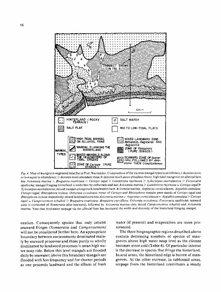
Fig. 4. Map of mangrove-vegetated tidal flat in Port Warrender. Composi t ion of the various mangal types is as follows (= denotes more or less equal in abundance; > denotes more abundan t than; ~ denotes much more abundan t than): high tidal mangrove on alluvial fans has Avicennia marina ~ Bruguiera exaristata = Ceriops tagal > Lumnitzera racemosa > Xylocarpus australasicus > Excoecaria agallocha; mangal fringing hinterland is underlain by colluvium and has A vicennia marina > Lumnitzera racemosa = Ceriops tagal >> Xylocarpus australasicus; mixed mangals along creek headwaters have A vicennia marina, A egiceras corniculatum, Aegialitis annulata, Ceriops tagal, Rhizophora stylosa, Osbornia octodonta; zones of Ceriops and Rhizophora contain pure stands of Ceriops tagal and Rhizophora stylosa respectively; mixed landward zone has A vicennia marina = A egiceras eorniculatum = A egialitis annulata > Ceriops tagal = Camptos temon schuhzii > Bruguiera exaristata, Bruguiera parviflora, Osbornia oetodonta, Excoecaria agallocha; seaward zone is composed of Sonneratia alba (seaward), followed by Avicennia marina then mixed Camptostemon schultzii and Avicennia marina. Note that freshwater seepage via the alluvial fans has increased the width and diversity of the hinterland fringing mangal.
oration. Consequently species that only inhabit seaward fringes (Sonneratia and Camptostemon) will not be considered further here. An appropriate boundary between environments dominated main- ly by seaward processes and those partly to wholly dominated by landward processes is mean high wa- ter neap tide. Below this level mangals are flooded daily by seawater; above this boundary mangals are flooded with less frequency and for shorter periods as one proceeds landward and the effects of fresh
water (if present) and evaporat ion are more pro- nounced.
The three biogeographic regions described above contain decreasing numbers of species of man- groves above high water neap level as the climate becomes more arid (Table 4). Of particular interest is the decrease in species that fringe the hinterland. In arid areas, the hinterland edge is barren of man- groves. At the other extreme, in subhumid areas, seepage from the hinterland contributes a steady
17
HINTERLAND : ROCKY ~ MUDDY SEDIMENTS OF TERRAIN AND COLLUVIUM ~!.~.~i<~1 THE TIDAL FLAT
SEAWARD ZONE OF LANDWARD ,p MANOAL MANGAL Rhizophora MANGAL FRINGING THE ZONES ZONE HINTERLAND
GROUNDWATER 3 180 • SALINITY
SEPT 1978 / / 160. ---0-- M ~ NN~
140.
i20.
00-
80-
60-
40-
20- ~
°
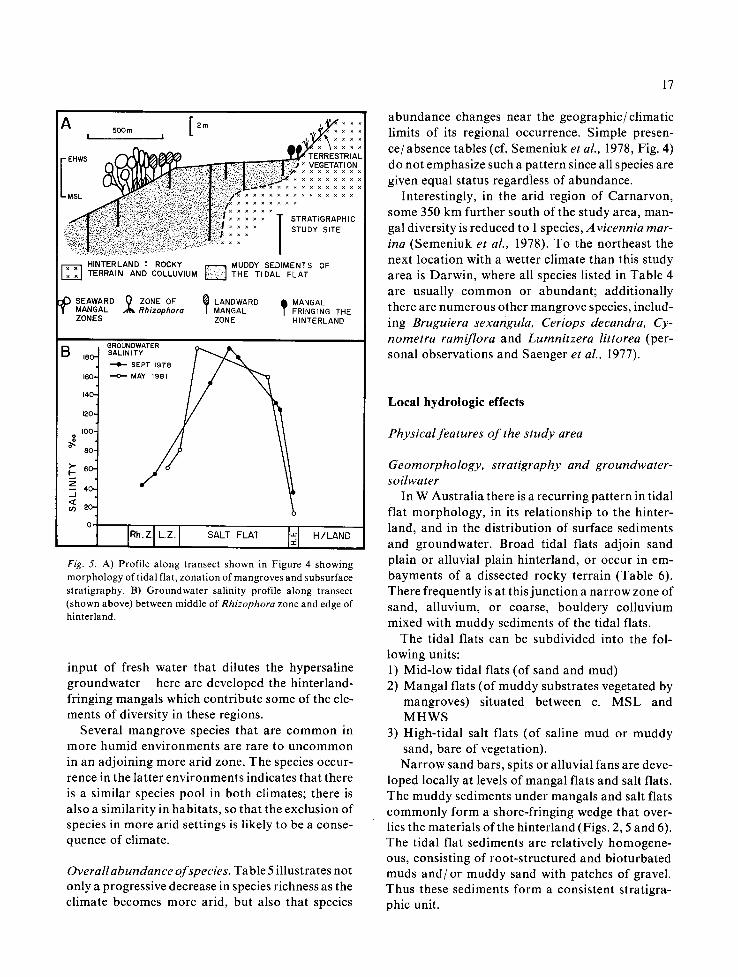
Fig. 5. A) Profile along transect shown in Figure 4 showing morphology of tidal flat, zonation of mangroves and subsurface stratigraphy. B) Groundwater salinity profile along transect (shown above) between middle of Rhizophora zone and edge of hinterland.
input of fresh water that dilutes the hypersaline groundwater - here are developed the hinterland- fringing mangals which contribute some of the ele- ments of diversity in these regions.
Several mangrove species that are common in more humid environments are rare to uncommon in an adjoining more arid zone. The species occur- rence in the latter environments indicates that there is a similar species pool in both climates; there is also a similarity in habitats, so that the exclusion of species in more arid settings is likely to be a conse- quence of climate.
Overallabundance of species. Table 5 illustrates not only a progressive decrease in species richness as the climate becomes more arid, but also that species
abundance changes near the geographic/climatic limits of its regional occurrence. Simple presen- ce/absence tables (of. Semeniuk et al., 1978, Fig. 4) do not emphasize such a pattern since all species are given equal status regardless of abundance.
Interestingly, in the arid region of Carnarvon, some 350 km further south of the study area, man- gal diversity is reduced to 1 species, Avicennia mar- ina (Semeniuk et al., 1978). To the northeast the next location with a wetter climate than this study area is Darwin, where all species listed in Table 4 are usually common or abundant; additionally there are numerous other mangrove species, includ- ing Bruguiera sexangula, Ceriops decandra, Cy- nometra ramiflora and Lumnitzera littorea (per- sonal observations and Saenger et al., 1977).
Local hydrologic effects
Physical features of the study area
Geomorphology, stratigraphy and groundwater- soilwater
In W Australia there is a recurring pattern in tidal flat morphology, in its relationship to the hinter- land, and in the distribution of surface sediments and groundwater. Broad tidal flats adjoin sand plain or alluvial plain hinterland, or occur in em- bayments of a dissected rocky terrain (Table 6). There frequently is at this junction a narrow zone of sand, alluvium, or coarse, bouldery colluvium mixed with muddy sediments of the tidal flats.
The tidal flats can be subdivided into the fol- lowing units: 1) Mid-low tidal flats (of sand and mud) 2) Mangal flats (of muddy substrates vegetated by
mangroves) situated between c. MSL and MHWS
3) High-tidal salt flats (of saline mud or muddy sand, bare of vegetation). Narrow sand bars, spits or alluvial fans are deve-
loped locally at levels of mangal flats and salt flats. The muddy sediments under mangals and salt flats commonly form a shore-fringing wedge that over- lies the materials of the hinterland (Figs. 2, 5 and 6). The tidal flat sediments are relatively homogene- ous, consisting of root-structured and bioturbated muds and /or muddy sand with patches of gravel. Thus these sediments form a consistent stratigra- phic unit.

18
E-----...--~ ~=~:--~
B TRANSECT I
Ikm
2m I I MUDDY TIDAL FLAT SEDIMENTS
g ,~ tl/ TERRESTRIAL FLORA ~ DUNE SAND
C
180 -
140-
o
ioo
TIDAL CREEK OR CHANNEL
MAIN MANGAL DEVELOPED BETWEEN MS.L AND M.H.W,S
SALT FLAT
MANGAL DEVELOPED ALONG HINTERLAND EDGE
HINTERLAND OF SAND DUNES
TRANSECT 2 FRESHWATER INFLUX
/ - S T U DYASIDT EGSR FOR D~TRTAET/G RAPH Y
- 7 7 - - . - - . . . . . . . . . . %°o'
'WATER'TABLE ~::!:~ : ) ~ z ::°::~°:: o :°gO:°::°~%~o:f ..... {~::,=:7:;;.: ~ f,'::';;; s ~ . ::::::::::::::::::::::::::::::::
I MANGROVES
Rhizophoro Avicennio Avicennio, AND Cer~ps Cer~ps AND
Excoecaria
TRANSECT ] TRANSECT 2
, I km j / / l l . . / ~ 180" I I km i ~ * 1 ~ 1
/
lOC '
R, I SA,T FLATH,LAN¢I SALT FLAT fl '.0 Fig. 6. A) Map of tidal flat along shore of Stokes Bay. The main mangal (between MSL and M HWS) is internally zoned and consists of ffeaward A vicennia and Camptostemon, followed by a zone of Rhizophora; to landward there is A vicennia and discrete grove s and bands of Ceriops. The mangal along the edge of the hinterland is located at sites of freshwater seepage and consists ofAvicennia, Cerops and Excoecaria. B) Profiles along transects 1 and 2 showing stratigraphy and sampling sites. C) Groundwater salinity profile along transects 1 and 2. Note the effect of freshwater on the normally highly hypersaline groundwater at landward portions of the salt flat.
The g roundwate r regime is an impor t an t and pervasive system at shallow depths under t idal flats: it is <30 cm deep on mid t idal parts of t idal flats, and occurs at progressively deeper levels toward l andward parts (0.5 m deep increasing up to 2 m or 3 m). The salinity of g roundwate r progressively in- creases to l andward (Table 7, Figs. 5, 6 and 7) with
mean values of 35-40%0 at the seaward edge oI mangals , 48%0 in the interior ( R h i z o p h o r a zones) of mangals and 69-90%o at the landward edge of man- gals; thereafter depending on the size of the flats, the salinity increases up to 283%o across salt flats. It appears that 90%o salinity is the threshold of man- grove tolerance.

19
x × x ~ . . . . . . . . . . . x x x . . . . ~ x x x × × × . . . . . U N I T T IDAL L E V E L
~ e L ' ~ ' ~ i r T R A N S E C T 4 . . . . . . . . . . . ~ . . . . . . . . . . . . I I MUD ~ SAND FLATS LOW ~ - : ~ _ _ ~ " . . . . . . . . . . . . . . ~ . . . . . . . . . . . . "t.', x x TO
~ = ~ ! ~ ~ . x / ~ x X 4 ~ [--+-] ROCKY SHORE REEFS M I D .
I x x ~ x x x x x ~ - ~ ZONE OF . , X E O _ ~ l Avicennio ~ Rhizophora z I MID
. . . . . . . . . " -:--" - . . . . . . . . . ~-:---- I ~ r ' ~ZONE OF Rh lzophora - ' ~ I , r o , x x x x x x , ~ - - - - - - : - S ~ ~------_----E. t . -~4 0 I m n
x x " --~'---------------"---:=~ "-=~----------- ~ i l z o N E OF Brugu ie ro - ~1 • - . ~ , ~ F,.~.,.:._.,,~_-j..~ . . . . "--~ _-[------ 1 ~-- - - -~ ~ A v i c e n n i o ( & CeHops) - I
" " ~ : .... ~ ' ~ '° ~--------------------- [ ] SANDY BEACH HIGH ¢>,, "~ ':;~" ~ - - - - C - - - _ - - _ - - _ - - _ - - - _ - -
I ~ - - - ~ [ ] SALT ~LA'r
x . . o , , .,,~° ~ C O A S T A L DUNE OR -,"=De, ce,"r ,d':~:- ~-_--~-~-~- . . . . . ~ BEACH RIDGE ~I~A'2,C,~"2Nb -
~ ~ ~-'~"xl PRE-CAMBRIAN ROCK 3UPRA - ~ ~ . . . . . . . . . . ' ' ~ O R ~ , N SO,L ON ROC~ T,DAL
1 6 0 "
I I 0 0
o~ 120"
" T R A N S E C T . 1_ GROUNDWATER S A L I N I T Y
z 8o-
_ , ~ I F / + AUG 1980 i APRIL 1981
40- -----A--- MAY 1981
B R ~ , SALT FLAT ] H / LAND
Fig. 7. A) Map of King Bay, Dampier Archipelago showing zonation of tidal flat in terms of geomorphic units, zonation of mangal and location of transects. B) Groundwater salinity profiles along transect 1.
Soilwater salinity exhibits a similar pattern to groundwater salinity. Values increase to landward, reaching a mean of 500/00 in mid R h i z o p h o r a zones, 840/00 in landward zones, 1560/00 in seaward parts of salt flats and progressing up to 267%0 in landward parts of salt fiats (Table 7). Soilwater salinity values are slightly to moderately higher than groundwater salinity for the same location. Replicate sampling shows that soilwater salinity however is more vari- able than groundwater salinity because of 1) micro- topographic differences (5-30 cm relief) in mangal soil environments, 2) crab excavations recycling subsurface soils of various salinities, 3) burrow and root conduits for recharge into the soil, and 4) textural differences of sand vs mud vs gravel in
small-scale mosaics on the surface. Recharge of groundwater and soilwater and modification of sa- linity takes place during tidal flooding when soil- water is flushed of excessive salinity. Evaporat ion and transpiration particularly during the ensuing neap period re-establishes high values of salinity.
Groundwater and soilwater salinity develop pa- rallel trends across tidal fiats and either one could be used as an overall salinity index. However, em- phasis is placed on groundwater salinity henceforth in this paper because: 1) it is less variable than soilwater salinity (Table 7), 2) most mangrove roots are lodged in the permanently saturated phreatic zone rather than the surface soil zone, 3) soilwater salinity is a max imum value only at the surface;

2O
Table 2. Zonation of mangals from selected areas.
Area Mangal/Tidal fiat zones
Seaward zone Central zone Landward zone Salt flat Fringe of mangal along hinterland
Port Warrender seaward Sonneratia Zone of Rhizophora mixed Avieennia Narrow Avicennia, followed by Avicennia (generally pure stands) Aegialitis, Aegiceras, Ceriops, and then Camptosternon some Camptostemon, Lumnitzera,
Bruguiera and Ceriops; Xylocarpus locally developed Ceriops pure stands
Fitzroy River seaward Avicennia zone of Rhizophora mixed Avicennia, Broad rare Avicennia Estuary; followed by Avicennia/ locally mixed with Aegialitis, Aegiceras or Ceriops Stokes Bay Camptostemon Avieennia and some Camptostemon or Excoecaria
Camptostemon Ceriops; Ceriops locally forms pure stands; Excoecaria
Willie Creek; seaward Avicennia zone of Rhizophora mixed Avicennia, Broad rare Avicennia Dampier Creek followed by Avicennia/ locally mixed with Aegialitis, Ceriops Ceriops or
Camptostemon Avicennia and Excoecaria Excoeearia or Carnptostemon Lumnitzera
Port Hedland seaward Avicennia zone of Rhizophora mixed Avicennia, Broad None Aegialitis and Ceriops
Pt. Samson/ seaward Avicennia zone of Rhizophora mainly Avicennia locally Broad None Cossack and Aegialitis and Ceriops Dampier Archipelago
ini t ia l ly it decreases with dep th in the vadose zone bu t increases at g rea te r dep th unt i l it merges with g r o u n d w a t e r sal ini ty, 4) it is the g r o u n d w a t e r sys- tem tha t is affected by subsurface seepage,
Local variation o f stratigraphy, hydrology and groundwater salinity
Cores , t renches and pits show tha t there may be local va r i a t i on in the s impl i f ied t idal f lat s t rat i - g raphy descr ibed above. Mos t of the va r ia t ion oc- curs where the salt f la t jo ins the h in t e r l and and is due to the type of mater ia l s deve loped a long the con tac t and the geomet r i c con f igu ra t ion of the junc t ion . A local va r i a t ion in s t r a t ig raphy also af- fects the hydro log ic sys tem (and sal ini ty) of an a rea since aqui fers and aquae ludes are l inked to the s t ra t ig raph ic f ramework .
S ix va r ia t ions to the s t r a t ig raph ic re la t ionsh ip of the h i n t e r l a n d / t i d a l flat j unc t ion were encounte red in this s tudy (Fig. 8). These va r ia t ions essent ial ly are e i ther d is t inc t sed iment units or interfaces ( im-
bedded in an otherwise relat ively homogeneous ti- da l mud accumula t ion ) which then func t ion as aquifers or aquac lude interfaces. Where these stra- t i g r a p h i c / a q u i f e r units ex tend f rom the h in te r land into the t idal f lat subsurface the g roundwa te r has a lower sa l in i ty wi th in the aquifers as c o m p a r e d to tha t under m u d d y salt f lats (see next section), indi- ca t ing tha t fresh water has invaded the hypersa l ine system.
Distr ibut ion o f rnangal in relationship to local hy- drology
With in any given area of mangal , there is a recur- r ing pa t t e rn of mangrove species d i s t r ibu t ion (Ta- bles 2 and 3). However there are var ia t ions on the bas ic pa t t e rn in that 1) mangals f r inging the hinter-
l a n d may be local ly wider or conta in add i t iona l species; 2) manga l s may be deve loped as i sola ted pocke t s on salt flats; 3) manga l s may be deve loped a long the edge of a sand bar , or spit . These a typ ica l

Table 3. Occurrence of mangrove species with respect to tidal flat zones.
Biogeographic region/ Mangrove species Climate
Main mangrove belt Salt flat Hinterland fringe Hinterland fringe with marked freshwater seepage
REGION I/Tropical Aegialitis annulata NONE Aegialitis annulata Aegialitis annulata subhumid Aegiceras corniculatum Aegiceras corniculatum Aegiceras corniculatum
Avicennia marina Avicennia marina Avicennia marina Bruguiera exaristata Excoecaria agallocha Bruguiera exaristata Bruguiera parviflora (Pemphis acidula) Bruguiera parviflora Camptostemon schultzii Lumnitzera racemosa Ceriops tagal Ceriops tagal (Scyphiphora hydrophylacea) Excoecaria agallocha Excoecaria agallocha Xylocarpus australasicus (Pemphis acidula) Osbornia octodonta Lumnitzera racemosa Rhizophora stylosa (Scyphiphora hydrophylacea) Sonnerartia alba Xylocarpus australasicus (Xylocarpus australasicus)
21
REGION II/Tropical Aegialitis annulata NONE semiarid Aegiceras corniculatum
Avicennia marina Bruguiera exaristata Bruguiera parviflora Camptostemon schultzii Ceriops tagal E×coecaria agallocha Osbornia octodonta Rhizophora stylosa (Sonneratia alba) (Xylocarpus australasicus)
rare Avicennia marina rare Excoecaria agallocha
Avicennia marina Ceriops tagal Excoecaria agallocha Lumnitzera racemosa (Xylocarpus australasicus)
REGION Ill/Tropical Aegialitis annulata NONE arid Aegiceras corniculatum
Avicennia marina Bruguiera exaristata Ceriops tagal Osbornia octodonta Rhizophora stylosa
NONE Avicennia marina Ceriops tagal
Brackets 0 denote this occurrence is not common
incurs ions or extensions of mangals are located above a localized less saline g roundwate r which occurs in discrete patches directly related to strati- g raph ic /aqu i fe r units. Field studies i l lustrat ing the effect of sub te r ranean fresh water on mangrove d is t r ibut ion are f rom the fol lowing areas: 1) Por t War render (tropical, subhumid) to illus-
trate freshwater seepage via alluvial fans and colluvial sheets (Figs. 4 and 9).
2) Stokes Bay (tropical, semiarid) to il lustrate seepage from a cliffed dune h in ter land (Fig. 6).
3) Por t Hedland (tropical , arid) to i l lustrate seep- age from a l imestone terrain (Fig. 10).
4) Dampie r Archipelago (tropical, arid) to illus-
trate the effect of local seepage via alluvial fans (Fig. 11).
In each case fresh water is f lowing into the tidal g roundwate r for most of the year dur ing both dry and wet seasons, and is ma in t a in ing a salinity such that mangroves can inhabi t the surface.
Mechanism o f f reshwater seepage
Ident i fy ing the mechanism of freshwater seep- age rests on in tegra t ing s t ra t igraphy with ground- water sal inity data, as well as observat ions on water flow at the surface and points of seepage (springs). Observat ions dur ing wet seasons at Mitchell River

22
Table 4. Occurrence of mangrove species with respect to tidal levels.
Tropical subhumid Annual rainfall >1000 mm
Tropical semiarid Annual rainfall ca. 500-600 mm
Tropical arid Annual rainfall ca. 300 mm
All species above HWN Aegialitis annulata Aegiceras corniculatum Avicennia marina Bruguiera exaristata Bruguiera parviflora Camptostemon schultzii Ceriops tagal Excoecaria agallocha Lumnitzera racemosa Osbornia octodonta Pemphis acidula Scyphiphora hydrophylacea Xylocarpus australasicus
Aegialitis annulata Aegiceras corniculatum Avicennia marina Bruguiera exaristata Bruguiera parvifiora Camptostemon schultzii Ceriops tagal Excoecaria agallocha Lumnitzera racemosa Osbornia nctodonta Xylocarpus australasicus
Aegialitis annulata Aegiceras corniculatum Avicennia marina Bruguiera exaristata Ceriops tagal Osbornia octodonta
Species occurring exclusively only above HWN
Bruguiera exaristata Bruguiera parviflora Ceriops tagal Excoecaria agallocha Lumnitzera racemosa Osbornia octodonta Pemphis acidula Scyphiphora hydrophylacea Xylocarpus australasicus
Bruguiera exaristata Bruguiera parviflora Ceriops tagal Excoecaria agallocha Lumnitzera racemosa Xylocarpus australasicus
Bruguiera exaristata Ceriops tagal Osbornia octodonta
All species along hinterland edge
Aegialitis annulata Avicennia marina Bruguiera exaristata Bruguiera parviflora Ceriops tagaI Excoecaria agallocha Lumnitzera racemosa Pemphis acidula Scyphiphora hydrophylacea Xylocarpus australasicus
Avicennia marina Ceriops tagal Excoecaria agallocha gumnitzera racemosa Xylocarpus australasicus
Avicennia marina Ceriops tagal
Species occurring exclusively along hinterland edge
Excoecaria agallocha Lumnitzera racemosa Scyphiphora hydrophylacea Pemphis acidula
Excoecaria agallocha Lumnitzera racemosa Xylocarpus australasicus
NONE
estuary, Por t Warrender , Fi tzroy River estuary, Mai t l and River delta and Dampier Archipelago indicate that ra in fall ing on salt flats may not infil- trate directly into substrates. Par t icular ly if salt flats are muddy, ra inwater flows in the same way as an ebbing tide. Excavat ions show intensive water- logging confined to the upper 10 cm. In the man- grove zone and on the seaward marg in of the salt fiat, some rain water flowed off the surface (as does the ebb tide) and some also infi l trated down nu- merous an imal burrows, old (decayed) roots, sand
pipes and ped boundar ies , indicat ing the impor- tance of these structures in t ransferr ing rainwater directly to the saline groundwater .
The salinity of tidal flat groundwater , however, was not lowered significantly immediately after heavy ra in dur ing the wet season. Al though there is a small d i lut ion response due to gravitat ing rainfall, at least in the upper parts of the soil profile, the g roundwate r salinity field (or structure) is main- tained. Fur the rmore the d i lu t ion effect by infiltrat- ed or surface fresh water can be eradicated within

Table 5. Occurrence and relative abundance ° of mangrove species in tropical Northwestern Australia.
23
Species
Biogeo- Biogeographic Biogeographic graphic region lI region III region I
.>. ~ m o
.~ "~
.#
Avicennia marina Rhizophora stylosa Ceriops tagal Aegialitis annulata Aegiceras corniculatum Bruguiera exaristata Osbornia octodonta Camptos temon schultzii Excoecaria agallocha Xylocarpus australasicus Sonneratia alba Lumnitzera racemosa Bruguiera parviflora Pemphis acidula + Scyphiphora hydrophylacea +
a a a a a a a a a a a a a a a a a a a a a p p a a a a a a a a a a p a p
P P P P P P P P P P P P P P P P P P P P P P P p p p u p / u p / u u u u u p /u p p p p p p p p u u u u a a a a / p a / p p a /p a /p a /p u a /p p p p p p p p p p / u u p p p u p / u .
P P P P p p p r u r u u p / u r
a a a a a a a a a
a a a a p a a p p
a /p a /p p p u p p p /u u p p p p u p p r p u p p u u p /u p / u r p /u p /u u p / u u U u u
o = gross estimates of abundances of mangrove species: a = conspicuously abundant or at least common (/> one tree in a stand of 10) a / p = abundant , common, varying to present p = present (~> one tree in a stand of 100) p / u = present to uncommon u = uncommon (/> one tree in a stand of 1 000) r = rare (< one tree in a stand of 10 000, a number usually covering 0.01 0.1 km 2)
= absent * = data from aerial photographs; George & Kenneally, in Miles & Burbridge (1975); and Kenneally (pers. comm.) + = not found in any of the study sites; though these species are known to occur in tropical subhumid areas along the Kimberley coast
(Semeniuk et al., 1978), occurrence is rare
t h e f o l l o w i n g s p r i n g t i d e - n e a p t i d e p e r i o d w h e n t h e
n o r m a l s a l i n i t y o f t h e g r o u n d w a t e r is r e - e s t a b -
l i s h e d . T h e r e is f r e q u e n t l y a m o r e p r o n o u n c e d d i l u -
t i o n o f s a l i n i t y b y s p r i n g t i d e r e c h a r g e ( S e m e n i u k ,
i n p r e p . ) .
T h u s i t w o u l d a p p e a r t h a t a c o n s i s t e n t r a t h e r
t h a n a n i n t e r m i t t e n t s u p p l y o f f r e s h w a t e r is r e -
q u i r e d i f l o w s a l i n i t y f i e l d s f o r h i n t e r l a n d f r i n g i n g
m a n g a l s a r e t o b e m a i n t a i n e d f o r a l l s e a s o n s .
A q u i f e r s o n t h e h i n t e r l a n d p r o v i d e t h i s y e a r - r o u n d
s o u r c e o f f r e s h w a t e r ( F i g . 12). D u r i n g t h e w e t
s e a s o n t h e , f r e s h g r o u n d w a t e r m o u n d o f a c o a s t a l
h i n t e r l a n d is r e c h a r g e d ( T o d d , 1959) . T h e e x c e s s
g r o u n d w a t e r o f t h e m o u n d f l o w s s e a w a r d t o a c h i e v e
h y d r o s t a t i c e q u i l i b r i u m . T h e r e is c o n t i n u a l s e e p a g e
t o w a r d t h e s e a ( T o d d , 1959 ) , e v e n i n t o t h e d r y
s e a s o n . I n a w e t t e r c l i m a t e t h i s c o u l d i n v o l v e l a r g e r
a m o u n t s o f w a t e r a s w e l l a s a l o n g e r d u r a t i o n o f
s e e p a g e .
F r e s h w a t e r s e e p a g e a l l o w s a v a r i e t y o t m a n g a l
t y p e s t o f r i n g e t h e h i n t e r l a n d ( F i g . 13). T h e f r e s h
w a t e r f i n d s p r e f e r e n t i a l p a t h w a y s t h r o u g h a p p r o -
p r i a t e a q u i f e r s a n d i n v a d e s a g r o u n d w a t e r s y s t e m
t h a t w o u l d o t h e r w i s e b e h i g h l y h y p e r s a l i n e ; m a n -
g r o v e s i n h a b i t t h e f l a t s i m m e d i a t e l y a b o v e t h e l o c a -
l i s e d a r e a o f l o w e r s a l i n i t y . T h e p l a n s h a p e o f t h e
24
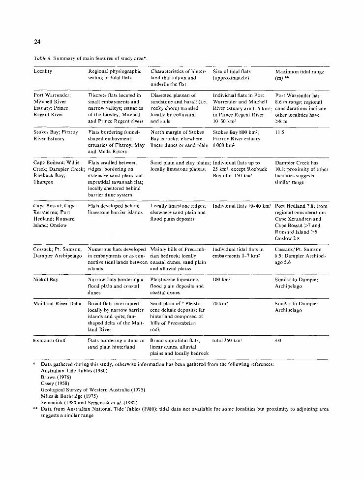
Table 6. Summary of main features of study area*.
Locality Regional physiographic setting of tidal flats
Characteristics of hinter- land that adjoin and underlie the flat
Size of tidal flats (approximately)
Max imum tidal range (m) **
Port Warrender; Mitchell River Estuary; Prince Regent River
Discrete flats located in small embayments and narrow valleys; estuaries of the Lawley, Mitchell and Prince Regent rivers
Dissected plateau of sandstone and basalt (i.e. rocky shore) mantled locally by colluvium and soils
Individual flats in Port Warrender and Mitchell River estuary are 1 5 kin2; in Prince Regent River 10 30 km 2
Port Warrender has 8.6 m range; regional considerations indicate other localities have >8 m
Stokes Bay; Fitzroy River Estuary
Flats bordering funnel- shaped embayment; estuaries of Fitzroy, May and Meda Rivers
North margin of Stokes Bay is rocky; elsewhere linear dunes or sand plain
Stokes Bay 800 km2; Fitzroy River estuary 1 000 km 2
11.5
Cape Boileau; Willie Creek; Dampier Creek; Roebuck Bay; Thangoo
Flats cradled between ridges; bordering on extensive sand plain and supratidal savannah flat; locally sheltered behind barrier dune system
Sand plain and clay plains; locally limestone plateau
Individual flats up to 25 km2, except Roebuck Bay ofc . 150 km 2
Dampier Creek has 10.1; proximity of other localities suggests similar range
Cape Bossut; Cape Keraudren; Port Hedland; Ronsard Island; Onslow
Flats developed behind limestone barrier islands
Locally limestone ridges; elsewhere sand plain and flood plain deposits
Individual fiats 10-40 km 2 Port Hedland 7.8; from regional considerations Cape Keraudren and Cape Bossut >7 and Ronsard Island >6; Onslow 2.8
Cossack; Pt. Samson; Dampier Archipelago
Numerous flats developed in embayments or as con- nective tidal lands between islands
Mainly hills of Precamb- rian bedrock; locally coastal dunes, sand plain and alluvial plains
Individual tidal flats in embayments 1-7 km 2
Cossack/Pt . Samson 6.5; Dampier Archipel- ago 5.6
Nickol Bay Narrow flats bordering a Pleistocene limestone, 100 km 2 flood plain and coastal flood plain deposits and dunes coastal dunes
Similar to Dampier Archipelago
Maitland River Delta Broad flats interrupted Sand plain of ? Pleisto- 70 km 2 locally by narrow barrier cene deltaic deposits; far islands and spits; fan- hinterland composed of shaped delta of the Malt- hills of Precambrian land River rock
Similar to Dampier Archipelago
Exmouth Gulf Flats bordering a dune or Broad supratidal flats, total 350 km 2 3.0 sand plain hinterland linear dunes, alluvial
plains and locally bedrock
* Data gathered during this study, otherwise information has been gathered from the following references: Australian Tide Tables (1980) Brown (1976) Casey (1958) Geological Survey of Western Australia (1975) Miles & Burbridge (1975) Semeniuk (1980 and Semeniuk et al. (1982)
** Data from Australian National Tide Tables (1980); tidal data not available for some localities but proximity to adjoining area suggests a similar range

Table 7. Groundwater/soil salinities.
25
Location of sample site Groundwater salinity as %0 Soilwater salinity as %0
Mangrove zone/ Tidal No. of Mean Range SD No. of Mean Range Geomorphic unit h e i g h t s samples samples
SD
Seaward edge of slightly 36 41.7 37 48 3.2 - - - Rhizophora zone above MSL
Mid Rhizophora 48 47.4 40 54 3.5 21 50.8 36-68 8.0 zone
Junction between slightly 38 55.3 48-66 4.3 14 54.4 37 92 18.5 zones of Rhizophora abo')e HWN and landward zone
Mid landward zone 63 69.0 53 88 10.1 31 84.1 40 168 37.6
Junction between 81 90.6 65 124 11.8 26 131.1 43 259 61.5 landward zone and the salt flat
Seaward portions of Approx. 82 116.9 89 166 18.3 25 156.3 80-262 44.8 salt fiat MHWS
Central portion of 56 163.3 121 199 26.2 6 247.7 178 301 43.9 extensive salt fiats
Junction of extensive EHWS 33 186.4 127-283 34.5 10 267.5 131-300 52.7 salt flats with the hinterland
Mangal along EHWS 72 69.1 14-106 21.1 9 85.0 50 163 38.8 hinterland margin
manga l is related to the conf igura t ion of the aquifer (Fig. 13). The width of the manga l is largely a func t ion of the a m o u n t of freshwater seepage which is related to phys iographic / s t ra t ig raphic set- t ing and to avai lable fresh water, i.e. rainfall (Fig. 14). In s u b h u m i d to humid regions where rainfal l is large, marked seepage a long the h in te r land edge may result in a progressive increase in width of h in te r l and fr inging manga l such that it merges with the ma in mangal belt with a resul tant loss of the salt fiat.
Discussion and conclusions
There are two main features of hydrology which influence fresh water / sa l ine water exchange and hence d i s t r ibu t ion of high tidal mangals ; these are - I) regional rainfall 2) local hydrologic (= stratigraphic) system
Regional rainfall largely determines the a m o u n t
and dura t ion of freshwater input into any envi- r o n m e n t (Fig. 14). It also regulates the a m o u n t and du ra t ion of seepage f rom the h in te r land into tidal lands after the wet season is over and hence can determine the width and diversity of h in ter land fr inging mangals.
The hydrologic system, which reflects the strati- graphy under t idal lands, is less obvious in that, it f requent ly is subsurface and can only be investigat- ed by t renching and coring. Surface physiography (such as dra inage channels) may point to obvious subsurface hydrologic systems but a featureless salt flat or mangrove-colonised tidal flat may cover a complex s trat igraphy in which various sediment types and interfaces act as aquifers and aquacludes (Fig. 8). Here the hydrology becomes an essential part of the mangrove ecosystem in that there can be recharge, or exclusion, or re tent ion of various groundwaters . C in t r6n et al. (1978) provide an ex- ample of the impor tance of such groundwate r / mangrove in teract ions with a descr ipt ion of the

26
K / S O I L RFACE
COLLUVIUM
BURIEI ( DEVE ~IK
LIME CE
D
Fig. 8. Schematic block diagram showing the various types of relationships between the wedge of tidal fiat sediments and the hinterland, and the pathways by which freshwater may invade the tidal lands. Location of paths of freshwater seepage is shown by arrows. A plan map of each of these blocks is presented in Figure 13. The examples and the areas they are drawn from are as follows: A) a tongue or fan of alluvium (delta) extends from the hinterland into the subsurface under the salt flats (e.g. Port Warrender area; Dampier Archipelago). B) a buried valley or channel cut into bedrock materials extends under the salt flats; this valley may also be filled with alluvium (e.g. Port Warrender; Dampier Archipelago). C) a sheet of colluvium underlain by a relatively impermeable rock interface extends under the salt flat (e.g. Port Warrender; Dampier Archipelago; Cossack). D) a platform of porous or cavernous limestone extends at shallow depths under the salt flats (e.g. Cape Boileau; Willie Creek; Port Hedland; Dampier Archipelago). E) sand sheets of the hinterland extend under the salt flats (e.g. Willie Creek; Dampier Creek; Port Hedland; Ronsard Island; Nickol Bay; Maitland River delta). F) a finger or bar of sand extends from a linear dune field into the subsurface of the salt flat (e.g. Stokes Bay; Fitzroy River estuary).
su rv iva l o f m a n g r o v e s b e h i n d a ba r r i e r d u n e in an
ar id e n v i r o n m e n t on M o n a I s l a n d ( n e a r P u e r t o
R i c o ) due to p o n d i n g of a l ow-sa l i n i t y g r o u n d w a -
ter. T h e f ie ld s tudies d e s c r i b e d in this p a p e r i l lus t ra te
the r e l a t i o n s h i p b e t w e e n m a n g r o v e d i s t r i b u t i o n
a n d a v a r i e t y o f p h y s i c o - c h e m i c a l f ac to r s such as
t ida l f ia t g r o u n d w a t e r , f r e s h w a t e r input , and s t ra- t i g raphy . T h e t ida l f la t s t r a t i g r a p h y is i m p o r t a n t in
its r e l a t i o n s h i p to the h i n t e r l a n d g r o u n d w a t e r sys- t e m a n d to h i n t e r l a n d d r a i n a g e pa t t e rns , be they
sur face- o r i n t e rna l types. I t is this h i n t e r l a n d / t i d a l - f la t s t r a t i g r a p h y t h a t in f luences f r e s h w a t e r dis-
c h a r g e in to t ida l l ands a n d so has a m a r k e d effect
on m a n g r o v e species d i s t r ibu t ion . C l i m a t e ( ra infa l l ,
t e m p e r a t u r e and evapora t ion ) p e r se is i m p o r t a n t in
t h a t f i rs t ly it m a y p r o v i d e a shor t , in tense , d i rec t
f r e s h w a t e r i n p u t a n d s e c o n d l y it m a y r egu la t e e v a p o r a t i o n on the h igh t idal flats. In tu i t ive ly ,
h o w e v e r , it m a y be in fe r red tha t l o n g - t e r m f resh-
w a t e r i n p u t f l o w i n g fo r m o s t o f the d ry season will
be a far m o r e e f fec t ive and in f luen t i a l c o n t r o l on
m a n g r o v e d i s t r i bu t i on . A f r e s h w a t e r r e se rvo i r lies
w i th in the h i n t e r l a n d , bu t the f resh w a t e r requ i res p a t h w a y s t h r o u g h wh ich it c an i n v a d e hype r sa l ine
g r o u n d w a t e r f ie lds i f it is to in f luence m a n g r o v e
d i s t r ibu t ion . Ana lys i s o f the s t r a t i g r a p h i c / h y d r o - log ic f r a m e w o r k is t h e r e f o r e essen t ia l to u n d e r -
s t a n d i n g m a n g r o v e d e v e l o p m e n t and z o n a t i o n , p a r t i c u l a r l y a l o n g the l a n d w a r d f r inge, because it
p r o v i d e s the key to u n d e r s t a n d i n g m e c h a n i s m s of
these s u b t e r r a n e a n f r e s h w a t e r incurs ions .

Ax. .... 9iiiii::!iiii ii::iii::::iiiiiiiii!
i:: ii!ii 'i' iiiiii- :i!i ii: :::::iiiiiii ::::::::::::::::::::::
~ . & , : . g o ~ ° o°. r~TNE .,NT.RLAHD L~ ~TO~O~ .*.E.SAL,NE ;" GA.%.O*~;~g HIGH TIDAL ~ SALT FLAT ~ FRESHWATER ~ HIGHLY HYPERSALINE SITE
~,'~A~,%LFO" . ~ • GRouNL~AC~',%MPL,NO~E F'ELo t ~O'*~"*~'~T&
C A ~ . . - - - E..W.S.
°
Im
F - ~ ~ LsOT~AT/ON TOEF
SURFACE UNITS
~ ROCKY TERRAIN OF HINTERLAND
MANGAL
~ SALT MARSH
[ ~ ] SALT FLAT
STRATIGRAPHIC UNITS
ROOTISTRUCTURED GREY CLAY
ROOT-STRUCTURED TO STRUCTURELESS BROWN CLAY AND SANDY MUD SAND WITH SCATTERED/ ABUNDANT PEBBLES
PEBBLE DEPOSIT
27
Fig. 9. A) Map of western port ion of Port Warrender tidal flat (see Figure 4) showing distribution of mangal types and location of s t ra t igraphic/groundwater salinity study sites. B) Inferred distribution of groundwater salinity fields, based on the sampling sites and distr ibution of soil units and vegetation units. Samples were collected near the end of the dry season one month before the first rains. C) Stratigraphic profile (sites A-D) illustrating the fan of alluvial sand and gravel forming the aquifer that allows fresh water to invade the highly hypersaline salt flat groundwater system.
45 I0 115 120
| 2Om ilrn] Rh.Z. ]L.Z. I SALT FLAT ] H/LAND
~ MUDDY SEDIMENTS OF NARROW _ _ THE TIDAL FLAT SALT FLAT
TERRESTRIAL SAND - - ~ X " l = ~ l ~ ' I I I I " ' I I '
[ ~ LIMESTONE WITH CAVES MHWS . . : . . . . - i J i
AND SOLUTION HOLES !
~ TERRESTR,A. FLORA .................. ~ ......... ~"~ f f 43 49 6Z lOT 105 40
(n r ~ AvicenMa ( LESSER Ceriops ) / Rh. z. IL.z. I SALT I:~1 H/LAND
~L# MIXED Avicenni. ,Ceriops,Aegiolitis
~' LOCATION OF STUDY SITES FOR STRATIGRAPHY AND GROUNDWATER
Fig. 10. Profiles across tidal flat at Port Hedland showing i) mangrove, salt flat and hinterland relationships; 2) tidal flat stratigraphy adjoining a hinterland of sand plain and limestone, and 3) groundwater salinity values at various sampling sites. The upper profile where the tidal flat adjoins a low-relief sand plain shows no pronounced freshwater seepage. The lower profile where the tidal flat adjoins a cliffed and terraced limestone terrain shows that freshwater has diluted the normally highly saline groundwater.
L 300 m i
• x x x x x x x x x x x x x x x
. * x x ~< x x x x x x x x x x x
, = x x x x x x x x x x .~
x x x x x I
~ MANGALFLANKING SAND DUNES
(Avicennio,Cer~ps Aegiafitis)
~ MANGAL ON GRAVEL FAN
(Awcennio , Ceriops )
2 8
wi th sho l low so i l )
COASTAL DUNE OR BEACH RIDGE
ALLUVIUM 8, GRAVEL
O~ooO 0= =o x SALT FLAT
~ 1 MID TO LOW-TIDAL FLAT
~ Rhizophoro FOREST~-~AvJcennia FOREST~ ¢ & SHRUBLANDS
WITH Ceriops TO LANDWARD
] S A N D DUNES
] H I G H TIDAL SANDY BEACH
- - " ~ S A L T M A R S H
[] S A L T F L A T
~ vicennio & Rhizophora FORESTS 81 SHRUBS
[] Avicennia SHRUBS 8L HEATH
~ Avicennia & Ceriops SHRUBLANDS
2 B SAMPLING SITE FOR GROUNDWATER & STRATIGRAPHY
~ M I D TO LOW TIDAL-FLAT
. % . . % . - % . ° % . • - . / ° . . • . - - . . ° - H . % . - - . / . . . . % . . - . ° . % - % / % . . % . ° % ° . % ° - % . . ° ° • ° . . - . . . % . • % / - . . . % ° . % . . % ° . % . • . % / % . ° % / . ° . ° ° . ° ° ° • H H ' % ° % ° ' % . ' ' . / % °• . °" . H ° . ' % / % / % . ' % ° % / " . ° % ° ' % • • ° ° ° ' H ' % . • O • . • • H ° ' ° . ' ' . . ° ' ° . ' ' % ° H • . ' ' • . °% . ' ' ° " ' . . • ° . . ' • . . ° ' . ° ' ' H ° ° • ° ° ' . . ' ' ° " ' . . • ° . . ' ' • . " . ° ' H ' % ° % . ' ' ° . H . / ' * . ' ' . . " " ' . . ' ° ° ° ' ' . ° ° • . . 0 " ° °°•° . '
,.. ,• . . . - .. , " . . . • . . - . . . • .. • - . . , •.. ," ,°. - •. . - . . . • . . • . . . " . , . - . . . - . . • . , . • • .- •. , " . . . " . . . ' , . . - • . . ' o 2 6 . . ' •, . " , , ," , . . - • . . . •. ."
: : : : : : : : : : : : : : : : : : : : : : : : : : : : : : : : : : : : : : : : : : : : : : : : : : . . . . o
: : : i : - " " " " " " !
° o e ~ - , - . ". ~ ~ , ~ ~ ; , - - . - . :.
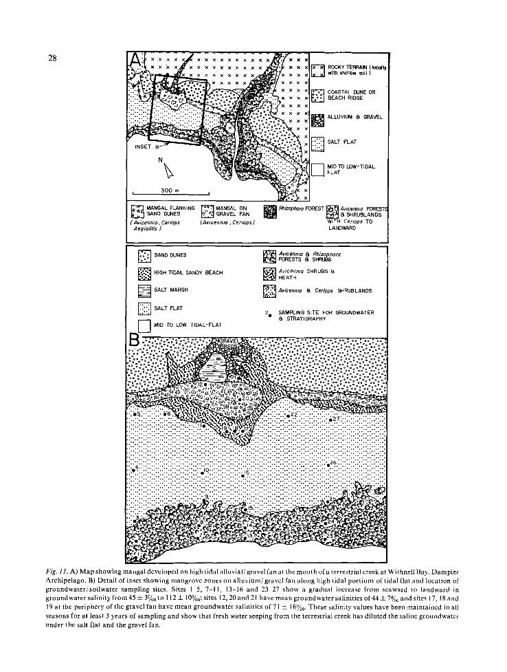
Fi E. ] I. A) IV] ap showing mangal developed on high t idal a l luv ia] /gravel fan at the mouth of a terrestrial creek at Withnell Bay, Dampier Archipelago. B) Detai l o f inset showing mangrove zones on a l luv ium/grave] fan along high t idal port ions o f t idal f iat and locat ion of groundwater /so i lwater sampling sites. Sites I 5, 7 I ] , 13-16 and 23 27 show a gradual increase f rom seaward to landward in groundwater sal ini ty f rom 45 4- 3%0 to l 12 4- 10%0; sites 12, 20 and 21 have mean groundwater sa]inities o f 44 4- 7%0 and sites l 7, l 8 and 19 at the periphery o f the gravel tan have mean groundwater salinities o f 71 4- i 8%0. These sal inity values have been maintained in all seasons for at ]east 3 years o f sampling and show that fresh water seeping f rom the terrestrial creek has di|uted the saline groundwater u n d e r t h e s a l t f l a t a n d t h e g r a v e l f a n .

ABSENCE OF ..~.-'.. z '", MANGROVE ALONG THIS / * . ° :
~-Z C kC/,~.'~c-, HINTERLAND MARGIN /~?;°,
g
E hizop ..... o Oo°°::::°::~{°:::?:::~°-~oO':,L°T-~=oT<:°~o:~::~::o[o~
t t t t t t t °2°0 I (.9 if') o
DISTANCE ALONG SURFACE
B FRINGE OF MANGROVE ALONG THIS HINTERLAND MARGIN
t t t t t t t
I ¢'~ I-- too z ~
o
DISTANCE ALONG SURFACE
29
Fig. 12. Generalised summary profile of tidal flat showing zonation of mangals, geomorphic zones and groundwater salinity (based on Table 7). A) Profile of groundwater salinity without freshwater seepage. B) Profile of groundwater salinity where there is pronounced freshwater seepage which influences salinity at the landward edge of the tidal flat and allows mangals to develop.
References
Austral ian Tide Tables, 1980. Austral ian Hydrographic Publ. II; Australian Government Publ. Serv., Canberra.
Brown, R. G., 1976. Exmouth Gulf. In: Logan, B. W., Brown, R. G. and Quilty, P. G. (eds), Carbonate Sediments of the West Coast of West. Australia. 25th Intern. Geological Con- gress, Sydney, 1976, pp. 55-75.
Bureau of Meteorology, 1973a. The Climate and Meteorology of West. Australia. In: West. Australia Year Book 12, Mel- bourne, pp. 36 54.
Bureau of Meteorology, 1973b. Atlas of Australian Resources: Temperatures. Commonweal th of Australia, Melbourne, 21 pp.
Bureau of Meteorology, 1973c. Atlas of Australian Resources: Rainfall. Commonweal th of Australia, Melbourne.
Bureau of Meteorology, 1975. Climatic Averages, West. Austra- lia. Australian Government Publ. Serv., Canberra, 82 pp.
Bureau of Meteorology, 1976. Climate of Australia. In: Official Year Book of Australia, 61. Commonweal th of Australia, Melbourne, pp. 25-76.
Casey, J. N., 1958. Derby-4 mile Geological series sheet E/51-7, Austral ian National Grid. Bureau Mineral Resources Aus- tralia explanatory notes Ser. 8.
Chapman , V. J,, 1976. Mangrove Vegetation. J. Cramer, Lehre, 447 pp.
Cintr6n, G., Lugo, A. E., Pool, D. J. & Morris, G., 1978. Man- groves of Arid Environments in Puerto Rico and Adjacent Islands. Biotropica, 10: 110-121.

30
~ x x x x x × x × x x x × x [3
. . . . . . . . . . . . . . . . . . . . . . . . .
C . . ~ : • ..:. r..::(I:..~:~:~':~.i..~ .~. •
i " " "
. . . . . . . . . . . . . . . . . . . . . . . . . .
- - z z z z z z z z z z z z z z z z z z z z z z z z _ . . . . . . . . . . . . . . . . . . . . . . . . . .
. . . . . . . . . . . . . . . . . . . . . . . . .
D
q
E F
~ Z - - - - Z~_--_--Z----
BEDROCK/TERRAIN ROCKY ~ SLOPEsCOLLUVIUM/SOl L ~ SALT FLAT ~ MAIN MANGROVE BELT BETWEEN M.S.L 8t M.H.W.S.
[ ~ LIMESTONE TERRAIN ~ DUNE SAND / ~ MID TO LOW-TIDAL ~ MANGROVES FRINGING
SAND PLAIN I I FLATS ~ THE HINTERLAND
F i g . 1 3 . Distribution of mangals along the hinterland margin in response to the freshwater seepage that is shown in the physiographic diagrams of Figure 8. The shape of the mangal is related to the shape of the freshwater aquifer and type of seepage. Point discharge from buried deltas and suberranean channels (e.g. A & B) results in a locally wide, diverse mangal, deltoid or rhomboid in plan shape. Seepage along a broad interface associated with colluvium sheets or a buried rock interface results in a continuous fringe of mangals along the hinterland edge (e.g. C & D). Seepage through buried fingers or hummocks of sand results in patchy distribution of mangal (e.g. E & F).
Clarke, L. D. & H a n n o n , N. J., 1970. The Mangrove Swamp and Salt-marsh Communities of the Sydney District. II]. Plant growth in relation to salinity and waterlogging. J. Ecol. 58: 351-369.
Gentilli, J., 1972. Australian Climate Patterns. Nelson Academ- ic Press, Melbourne, 285 pp.
Geological Survey of Western Australia, 1975. The Geology of Western Australia. Geological Survey of West. Aust., Mere. 2:541 pp.
K~ppen, W., 1936. Das Geographische System der Klimate, 1, C. In: KSppen, W. & Geiger, R. (eds), Handbuch der Klima- tologie, Berlin.
MacNae, W., 1968. A general account of the fauna and flora of mangrove swamps and forests in the Indo-West Pacific re- gion. Advances in Marine Biology 6:73 270.
Miles, J. M. & Burbridge, A. A., 1975. A Biological Survey of
the Prince Regent River Reserve North-west Kimberley, West. Australia. Wildlife Res. Bull. West. Australia, 3: 116 pp.
Milton, D., 1978. The rainfall from tropical cyclones in West. Australia. Geowest, Working Papers of the Dep. of Geo- graphy, University of West. Australia, 13- 61 pp.
Saenger, P., Specht, M. M., Specht, R. L. & Chapman, V.J. , 1977. Mangal and coastal salt-marsh communities in Austra- lia. In: Chapman, V. J. (ed.), Ecosystems of the world. I. Wet Coastal Ecosystems. Elsevier, Amsterdam, Vol. 1, pp. 293-345.
Semeniuk, V., 1980. Quaternary Stratigraphy of the tidal flats, King Sound, West. Australia. J. Royal Soc. of West. Austra- lia, 63: pp. 65 78.
Semeniuk, V. (in prep.). Tidal flat hydrology in tropical Northwestern Australia.

31
DELTA OR ALLUVIAL FAN
PHYSIOGRAPHIC FRAMEWORK
MID TO LOW-TIDAL FLATS
MA N MANGROV B L,.T ~ , ~.~_. _%.':, ZZZZZZZZZZZZZZZZZZ-Z
~---_--_----_~ C R EE K -----~- ~ - COLLUVlUM
x x "::[
RAINFALL (= INCREASED FRESHWATER SEEPAGE ) .~1 INCREASING
SUBHUMID CLIMATES
,...~..~. ~ ~;.~.,~..~,~,~ .... H NTERLAND
~ ~ " "~" " -. ,~ ~,J'o".~ .'- .., NGALS
SEMIARID CLIMATES ARID CLIMATES
~ - - - _ - 5 - " I-- OF FRESHWATER SEEPAGE-'----
-x-x x x x x x x x "~a'
i x × , I t × × × × × x ×
;g. 14. Schematic diagrams summarising the relationship between 1) tidal flat/hinterland physiography; 2) sites of frehswater input; 3) creasing regional rainfall, and 4) development of mangal along the hinterland margin in response to freshwater seepage. Size of arrow dicates relative importance of freshwater seepage sites.
emeniuk, V., Chalmer, P. N. & LeProvost, I., 1982. The marine environments of the Dampier Archipelago. J. Royal Soc. of West. Australia 65:97-114.
emeniuk, V., Kenneally, K. F. & Wilson, P. G., 1978. Man- groves of West. Australia. West. Australian Naturalists Club Handbook, 12, Perth.
odd, 13. K., 1959. Groundwater hydrology. John Wiley & Sons, Inc., New York, 336 pp.
Trewartha, G. T., 1968. An introduction to climate (4th ed.). McGraw-Hill Book Co., New York, 408 pp.
Walsh, G. E., 1974. Mangroves: a review. In: Reimold, R. J. & Queen, W.H. (eds), Ecology of Halophytes. Academic Press, New York, pp. 51-174.
Accepted 23.10.1982.