management plan 2006 - 2010...royal society for protection of nature 1 forest legislation and...
TRANSCRIPT

PPHHOOBBJJIIKKHHAA LLAANNDDSSCCAAPPEE CCOONNSSEERRVVAATTIIOONN AARREEAA Management Plan
2006 - 2010
TThhee RRooyyaall SSoocciieettyy ffoorr PPrrootteeccttiioonn ooff NNaattuurree

The Royal Society for Protection of Nature Post Box 325 Thimphu, BHUTAN All Rights Reserved © 2005

EXECUTIVE SUMMARY
The Royal Society for Protection of Nature (RSPN), the only non-governmental conservation organization in Bhutan, has been a key player in the conservation of the endangered Black-necked Cranes in Phobjikha valley. The survival of the Black –necked Cranes in Phobjikha, is linked with the humans. As residents of Phobjikha move down to the lower elevations of Ada to escape severe winter, their migration has safeguarded wintering cranes and their habitat in Phobjikha. Therefore, contributions to crane conservation from Ada as winter homes for several hundred households and their wetland farms, are of enormous values. To know more about Phobjikha valley, RSPN had completed two studies with vital information on how human experiences have shaped their natural surroundings including the survival of the Black-necked Cranes. Based on the occurrence of endangered species such as the Black-necked Cranes, White-bellied Heron, red panda and tigers, the preliminary boundary of the Phobjikha Landscape Conservation Area (PLCA) was delineated to include both Phobjikha and Ada. The boundary falls within 890 57’ 54” - 900 17’ 30” North and 270 13’ 50” - 270
31’ 27 East, with an area of 402.9 km2. Within the PLCA boundary, the Phobjikha valley (rim) was considered the crane area (161.9 km2 ; 900 5’ 55” – 900 17’ 30” North and 270 22’ 16” – 270 31’ 27” East). Seven major land-use were identified: agriculture, forest, scrub, marsh, water-bodies, pastures and settlements. Of these, ffoorreesstt were impressive as they covered almost 84.5% of the land, natural pasture was 8.4% and agriculture made nearly 4% of the land. Wetland farms in the lower valleys were small and much fragmented. In contrast, dry land farms at higher elevations, particularly Phobjikha valley, were large. There are seven vegetation types: broadleaf forest, mixed broadleaf forest, juniper forest, blue pine forest, mixed conifer forest, marsh, and open fields. A total of 55 tree species occur belonging to 19 families. A total of 73 shrub species are known to occur. Fern, fungi, moss and herbs make over 254 species from 43 families. Over 15 species of large mammals occur and some 88 bird species were seen in the winter season. Therefore, the checklist appears not to be comprehensive. In Phobjikha valley, there are 49 villages that support a population of 4,716 people in 498 households. Subsistence economy of Phobjikha valley is attributed to large family size and less productive population including children. As farms produce approximately 30% of total potato production in Bhutan, Phobjikha valley has cash crop economics (Food Corporation of Bhutan, Phuntsholing, 2003). Yak, cows, horses, sheep, goat, pigs and poultry constitute livestock, with a total of over 3,800 animals. Average fuel wood consumption is 31,158 kg (1,260 – 12,600 kg) and required annual fuel wood for all household was estimated to be 15,516.83 ton. Phobjikha may not represent a truly far-flung rural Bhutan, yet it faces many development issues including transport, electricity, communication and many others. In this regard, all households have a strong community interest in economic development. For the next five years, the village development priorities identified by
the 464 households were: 1) Building asphalt road from the national highway to Phobjikha; 2) Electricity in the Phobjikha valley; and 3) Building schools. For the purpose of safeguarding existing biodiversity and to maintain integrity of the ecosystems, PLCA is grouped into: 1) Critical wetland zone, 2) Critical forest and watershed zone, 3) Forest utility zone, and 4) Farms and settlement zone. Eight annual activities are prescribed under the zonation of PLCA. Under the nature conservation program, activities are: ecology of cranes, habitat register, wetland permanent monitoring sites, monitoring protocol on the tiger population, permanent vegetation plots in all forest types, ecological study and survey of White-bellied Heron, afforestation of degraded sites and development of options to inhibit crop raiding by wildlife. In Bhutan, DYT (Dzongkhag Yargye Tshogchung), and GYT (Geog Yargye Tshogchung) are the two fundamental steps for livelihood and development. To expedite the planning process of PLCA, an inter-active management role for RSPN is required along with DYT and GYT. To realize village priorities through the PLCA management plan, the Ninth Plan (2002 – 2007) of all four geogs, have been considered. Therefore, the PLCA management plan complements well with the royal government’s Five Year plans. The PLCA will be governed by the four geog committee chairperson, executive director of RSPN, manager of PLCA and representatives from the Department of Forest, and Dzongkhag Administration. For implementation of the management plan, the PLCA shall have the management capacity for one conservation manager, four assistant managers, two public-relation experts and three caretaker, totaling 10 staff in the central office in Phobjikha and a field station in Ada. For the effective protection of biodiversity and overall management, a field station will be located at Ada. Besides the protection-related responsibilities under their jurisdiction, the staff will look after allied activities as well. PLCA lacks infrastructure. To accomplish and facilitate the management plan, needed infrastructure will have to be built. The estimated budget for all planned activities comes under six subheadings. Of these, administration, nature conservation and human resource development hold major share of the estimated budget. The budget plan for the period 2006 – 2010 is estimated at NU 45.5 million.

ACKNOWLEDGEMENTS The management plan preparation team wishes to pay its respect and gratitude to His Royal Highness, The Trongsa Penlop, as the Patron of RSPN. The team is much thankful to Hon’ble Lyonpo Sangay Ngedup, Hon’ble Lyonpo Nado Rinchhen, and the RSPN Board of Directors for their valuable suggestions and kindness. Our thanks also goes to Dasho Sangay Thinley, Chairman of RSPN and Secretary of the Ministry of Agriculture. The team was much encouraged by the input of the task force constituted for the establishment of the Phobjikha Landscape Conservation Area. Technical assistance which was vital for science-based information, from Resources Himalaya Foundation, is also appreciated. We are also thankful to Mr. Gyaltshen, District Forest Officer, Territorial, Wangdue Dzongkhag Administration, Mr. Dophu, Gantey Gup, Mr. Wangchuk, Phobji Gup, Mr. Karma, Tshogpa of Bjena, Mr. Ugyen Dukpa from Health sector of Phobjikha, Mr. Yeshi Wangdi of Animal Husbandry and Mr. Sonam Rinchen, from Jigme Singye Wangchuck National Park.

THE MANAGEMENT PLAN PREPARATION TEAM 1. Dago Tshering Field Coordinator and Participatory Rural Appraisal 2. Lam Dorji, Ph. D. Economics, Agriculture, Natural Resources and Policy 3. Mincha Wangdi Review 4. Pralad Yonzon Ph. D Team Leader 5. Rebecca Pradhan Vegetation Ecology and Wildlife Conservation 6. Rinchen Wangmo Conservation Education and Coordination 7. Tshering Lham Information and Networking 8. Tshewang Norbu Field Biology

ACRONYM DBH Diameter (tree) at breast height DoF Department of Forest DYT Dzongkhag Yargye Tshogchung FMU Forest Management Unit GIS Geographic Information System GPS Global Positioning System GYT Geog Yargye Tshogchung MoA Ministry of Agriculture NEC National Environment Commission NCD Nature Conservation Division PLCA Phobjikha Landscape Conservation Area RSPN Royal Society for Protection of Nature

CONTENTS
EXECUTIVE SUMMARY ACKNOWLEDGEMENTS THE MANAGEMENT PLAN PREPARATION TEAM ACRONYM Chapter One INTRODUCTION BACKGROUND 1 ROYAL SOCIETY FOR PROTECTION OF NATURE 1 FOREST LEGISLATION AND CONSERVATION POLICIES 2 Chapter Two PHOBJIKHA VALLEY PHOBJIKHA VALLEY 3 PHOBJIKHA CONSERVATION AREA 3 ISSUES OF CONCERN 5 Chapter Three PHOBJIKHA LANDSCAPECONSERVATION AREA WHY LANDSCAPE LEVEL CONSERVATION? 7 LANDSCAPE-LEVEL KEY PARAMETERS 7 BOUNDARY DESCRIPTION 8 Chapter Four PHYSICAL GEOGRAPHY ELEVATION RANGE 10 LANDUSE PATTERN 11 CLIMATE 11 GEOLOGY 11 Chapter Five ECOLOGY BACKGROUND 12 VEGETATION 12 SPECIES RICHNESS AND SPECIES DIVERSITY 14 FOREST TYPES AND TREE DBH 15 SHRUB 16 HERBS 17 FAUNAL CHARACTERISTICS 17 Chapter Six SPECIES OF CONCERN BLACK-NECKED CRANE 19 TIGER 21 WHITE-BELLIED HERON 21 Chapter Seven VILLAGES AND HOUSEHOLD ECONOMY HUMAN POPULATION 22 LANDHOLDINGS 22 FARM ECONOMICS 24 LIVESTOCK 25 FOREST RESOURCES AND WILDLIFE DEPREDATION 26

VILLAGE PRIORITIES 26 Chapter Eight PLCA ZONATION AND REGULATORY FRAMEWORK BACKGROUND 28 CRITICAL WETLAND ZONE 28 CRITICAL FOREST AND WATERSHED ZONE 28 FOREST UTILITY ZONE 29 FARMS AND SETTLEMENTS ZONE 29 MANAGEMENT GUIDELINES 29 REGULATORY FRAMEWORK 31 ANNUAL ACTIVITIES 31 Chapter Nine NATURE CONSERVATION PROGRAM ACTIVITIES 32 BLACK-NECKED CRANES AND CRITICAL WETLANDS 32 TIGERS AND CRITICAL HABITATS 32 WHITE-BELLIED HERON 33 ECOSYSTEM INFORMATION AND MONITORING 33 FUELWOOD AND FOREST UTILITY ZONE 33 ANNUAL ACTIVITIES 34 Chapter Ten ENABLING COMMUNITIES VILLAGES AND GEOG PLANNING 35 MANAGEMENT STRUCTURE 36 GOVERNANCE 36 PROGRAM ACTIVITIES 36 ANNUAL ACTIVITIES 37 Chapter Eleven
ADMINISTRATION
STAFF STRUCTURE 38 FIELD STATION 38 STAFF RECRUITMENT 38 INFRASTRUCTUE DEVELOPMENT 38 Chapter Twelve BUDGET DETAILS 39 REFERENCES 42 ANNEX 43

- 1 -
Chapter One
IINNTTRROODDUUCCTTIIOONN BACKGROUND Bhutan has 72.5% of its 38,394 km2, under forest and its network of protected areas (PAs) with four national parks, one strict nature reserve and four wildlife sanctuaries cover approximately 26% of the total land area with an additional 9% forest biological corridors. Supplementing the PAs, four other ecologically significant areas have been enlisted for conservation for which the Royal Society for Protection of Nature (RSPN) has been recommended to manage. Of these, Phobjikha valley and Ada are globally significant because Phobjikha valley has one of the largest population of the Black-necked Cranes (Grus nigricollis) that arrives each winter from Tibet while Ada has nesting sites of the White-bellied Heron (Ardea insigniss), one of the 50 rarest bird species in the world. ROYAL SOCIETY FOR PROTECTION OF NATURE Since its inception in 1987, RSPN, the only non-governmental, conservation organization in Bhutan, has been a key player in conservation of the endangered Black-necked Cranes in the Phobjikha valley. Based on three guiding principles: 1) Respect Tsa-Wa-Sum; 2) Maintain transparency; and 3) Establish accountability, the mission of RSPN is to inspire personal responsibility and actively involve the people of Bhutan to protect its environment through education, applied research and information dissemination, and in collaboration with concerned agencies and indigenous institutions. Likewise, the RSPN 2005 – 2009 strategic plan includes: 1) Conservation of endangered species outside the protected area system; 2) Development of ecosystem - based approaches to manage critical areas; 3) Support and management of emerging urban environmental issues; and 4) Enhancing institutional capacity for environmental education, ecological research, and community-based natural resource management in Bhutan. With His Royal Highness, The Trongsa Penlop, the Crown Prince of Bhutan, as its Patron, RSPN is governed by a nine member Board of Directors, and supported by its executive office. With support of over 2,450 members across the country, RSPN nature clubs, support groups and individuals primarily consist of students, community youth leaders, and professionals who work together to bridge the gap between communities, institutions and government in their collaborative conservation efforts. For the continuity

- 2 -
of its vital role in conservation, RSPN has received several institutional support and capacity development funds from the Bhutan Trust Fund for Environmental Conservation, MacArthur Foundation, Sustainable Development Secretariat, Global Environment Facility’s Small Grant Program, World Wildlife Fund and several others including JICA (Japan), Kushiro International Wetland Centre (KIWC), SPIEC (Japan), SNV (Netherlands), Embassy of Finland (New Delhi), UNESCO and UNEP. FOREST LEGISLATION AND CONSERVATION POLICIES Policies and laws in Bhutan pertaining to conservation have progressed from forest based management to sustainable resource utilization and protection. While the 1969 Forest Act focused largely on traditional forest protection and introduced a utility system for forest resources through user permits, the 1974 National Forest Policy stated that 60% of the land area of Bhutan should be under forest cover and recognized protected area system as a long-term strategy to protect the flora and fauna. The need to manage forest resources systematically under different management tenures such as conservation areas, watershed protection forest, production forest and the local communities whose roles are crucial for sustaining forest resource is well recognized in Bhutan. The 1995 Forest and Nature Conservation Act mandates that conservation of biodiversity should be guided by their conservation value. Also, natural resources must be used on sustainable basis. The significance of this Act is that it ushered community forestry, critical watershed, protected areas and social forestry. Therefore, the Act recognizes that local communities can and shall contribute to biodiversity conservation. To address needs and forest utility issues in the context of legal and cultural settings of Bhutan, a system of local-level regulations with specific reference to localized conditions, traditional rules such as determining grazing rights (tsamdrog) and the communal use of forest resources, was much needed to equate sustainable use of renewable resources. The recent Forest and Nature Conservation Rules of Bhutan, 2000, has provided an appropriate legal framework for implementing the management plan with a significant degree of decentralization and land-use planning. The Revised Forest and Nature Conservation Rules, 2003 has further recognized Dzongkhag parks and sanctuaries on creation and designation of local recreational areas around villages. These newer sets of protection of areas require identification, feasibility studies (supported by the Department), declaration/ dissolution, approval of Management Plans and Monitoring & Evaluation by Dzongkhag Yargye Tshogchung (DYT) and Geog Yargye Tshogchung (GYT). Development is now enshrined with the resident communities, which is complimented by the objectives of the revised policy on decentralization, suggesting both conservation and development have a direct bearing on the local people.

- 3 -
Chapter Two
PPHHOOBBJJIIKKHHAA VVAALLLLEEYY PHOBJIKHA VALLEY Phobjikha valley is about 161.9 km2 with a mean elevation of 3,500 m. The highest ground is Lapchekha (4,200 m) and the valley floor is about 2,000 m. The Gangtey Goenpa in Phobjikha, is an important seat of Nyingmapa sect of Buddhism in Bhutan and it is one of the oldest monasteries. Although the valley spreads between Gangtey and Phobji Geogs of Wangdue Phodrang Dzonkhag, several households are settled from four additional geogs (Bjena, Ada, Nyesho, and Sephu) largely because of its vast summer pastures. The early settlers in Phobjikha were much influenced by the Gangtey Goenpa and extensive potato farming. After the construction of Gangtey Goenpa in the 16th Century, people from Punakha and Sha Valley moved and settled in the area. Kumbu households came from Sephu and settlements sprawled in Damchoe, Taphu, Khewang, Pisding and Gedechen. With the introduction of potato cultivation in Phobjikha in the early 1980s, people from other dzongkhags also migrated as potato farming became prosperous. Farms in the slope and valley floor now produce potato, radish and turnip as main crops. As initiatives began in the early 1990s to protect the habitats for the largest population of wintering cranes in Bhutan, allied development activities connected with tourism also attracted many families with small-scale businesses. Lately, tourism has shown potentials for economic prosperity but it must be equated with conservation and proven equity of the accrued benefits that tourism brings. PHOBJIKHA CONSERVATION AREA Phobjikha communities may represent a true rural setting in Bhutan as they constitute several development aspirations which may challenge or threat biodiversity conservation. Therefore, people are the key element of biodiversity conservation. To strengthen crane conservation through research and monitoring, wetland habitat management, and community development and organization, a two-year project entitled “Strengthening Protection and Management of Phobjikha Conservation Area” was initiated in 2003 with assistance from the MacArthur Foundation. As participation was deemed necessary for the larger benefit of the communities, program components included crane monitoring and research, wetland conservation, community development, social mobilization, conservation education, capacity development and human resource development, alternative energy and ecotourism. These programs are in general designed with the following goals and objectives in mind:

- 4 -
Goal To strengthen the conservation status of Phobjikha by encouraging community participation for biodiversity conservation Objectives Protect and maintain Phobjikha’s alpine, temperate and wetland ecosystems with specific protection to endemic and endangered flora and fauna using locally appropriate management strategies. Support environmentally viable economic benefit programs through participatory mechanism. Enhance participation and involvement of local communities, institutions, and relevant stakeholders in conservation, through capacity development, education or awareness programs. Develop Phobjikha as an integrated conservation model in Bhutan, from which lessons can be drawn and replicated in other parts of the country. For the larger benefit of the communities, geog representatives (villages) and sectoral representatives (development) constituted Phobjikha Conservation Area Program Committee (PCAP Committee). The committee effectively addressed local needs and issues, and drafted acceptable local decisions by which both communities and biodiversity would benefit. The committee had helped in securing community participation to implement program activities accordingly. For example, the Committee had played a major role in mobilizing people in many conservation programs including development of nature trails, organizing the Black-necked Crane festival, construction of the crane information center and several others. In future, participatory monitoring will be done to ensure timely implementation of project activities and to identify gaps and make necessary corrective actions. Also, research study will be undertaken on the threats, trans-boundary conservation, habitat identification and migratory routes of the Black-necked Cranes. To develop community-based ecotourism in the Phobjikha valley, RSPN’s intervention was based on UNESCO’s Project Framework on “Developing Cultural and Eco-tourism in the Mountainous Region of Central Asia and the Himalayas.” As of now, ecotourism in Phobjikha is geared towards development of nature based tourism packages/services that can bring tangible benefits to the resident communities who in turn will be motivated to conserve the natural environment. RSPN is working with the staff of the primary school and the five non-formal education centers at Phobjikha in assessing the education curriculum to develop materials that can complement the existing curriculum in conservation education. In alternative energy sector, solar photovoltaic electrification being the cheapest and most efficient, has been introduced since 2003. Till date a total of 205 households have been

- 5 -
fitted with SPV with financial assistance from United Nations Environment Program and Solar Electric Light Fund of USA. SPV light systems ranging from four-bulb system to a six-bulb system have been distributed to the households and local institutions including monasteries. Also, locals are being trained to repair and maintain the system. To promote land-based information on flora and fauna of the valley, household energy and water conservation initiatives, integration of women in decision making and building local leadership, RSPN has collaborated with several regional research organizations like International Center for Integrated Mountain Development, Resources Himalaya Foundation, International Crane Foundation and many others.
ISSUES OF CONCERN For decades, the communities in Phobjikha have coexisted in harmony with Black-necked Cranes, but influx of modern development have brought changes that are inevitably threatening the existence of the cranes and the only intact wetland in the country. The habitat of cranes in Phobjikha is shared with human land use and development activities. Any change in the land use pattern can therefore deter the stability of the crane habitat. As in other parts of the country, environmental problems/challenges in Phobjikha are associated with increase in anthropogenic activities and parallel change in the mindset and needs of the people. Present population of the valley is already about 5000, which will invariably increase with time. Associated changes like land fragmentation and smaller farm size and unplanned development activities is becoming evident in the valley, increasingly depriving the cranes of their original habitats. Some of the major changes will perhaps come with introduction of grid electricity in the valley during the next five to six years. This will inevitably accelerate the flow of modern facilities and allied development activities in the valley. The question is whether the valley will continue to be the favoured home for the cranes. While RSPN understands the genuine need of electricity for the people in the valley, it is also a responsibility for the organization to ensure that the electrification is done in an environmentally friendly way and that appropriate measures are in place to tackle the likely problems. RSPN is working with the Department of Energy to start preparing for this change. There is already immense pressure from outside to convert the valley particularly the wetland for commercial purpose. Interest from outside to invest for commercial purpose is becoming more evident each year. Many new commercial hotels and expensive resorts are sprouting, dominating local business in the valley. If the trend continues, the ecological carrying capacity of the valley will be affected inevitably. The wetland may eventually be drained out threatening the survival of the cranes. It is a sad fact that such outside dominated business usually have little regard to the natural environment and local needs. With increase in the number of resorts/hotels in the valley, flow of tourists/visitors in the valley is increasing simultaneously. In 2005 alone, 2,098 tourists visited the valley (source, RSPN Black-necked Crane Information centre, local hotels). Despite that, the local people ironically have little or no benefit from tourism. A proper management approach that monitor tourism and channels benefit to the local community is therefore a

- 6 -
necessity. One of the many side affects that can come with increasing visitors and commercial investments is the increase in waste. We do not have to wait too long, already waste is becoming a problem in the commercial areas of the valley. At the community level, the current agricultural practice, mainly potato cultivation, is leading to increasing use of chemical fertilizers and pesticides in the valley. Study done by RSPN in 2003 indicates that potato producing households use as high as 106.43 tons of sulphate and 54.5 tons of urea. Though there is no immediate threat seen, long term use is likely to pose significant effect on the quality of soil, wetland water and vegetation. Artificial nutrient inputs and use of wetland and surrounding catchment areas will eventually disturb the ecological balance of the wetland. This is compounded by increase in use of tractors that leave behind unplanned and irregular tracks/trails in the wetland. This has been particularly damaging to the wetland, resulting in soil erosion or runoff during the monsoon. Continuity of such practice may lead to drainage of the wetland affecting the roosting area of the Black-necked Cranes. Similarly, the age old tradition of cattle grazing in the wetland needs to be scientifically studied. While grazing is considered important to maintain height of bamboos, continued increase of cattle population in future may not be ecologically viable. Easy accessibility to forest and extreme climatic condition in the valley has encouraged people of Phobjikha to use substantial amount of wood for heating their homes, and various other purposes like cooking, construction and even for fencing. Most of the households use metal bukhari throughout the year for heating house and cooking. According to the recent study done by RSPN the average annual fuel wood consumption in the valley is about 31,158 kg and annual required fuel wood for all household was estimated to be 15,516.83 ton (RSPN, 2004). To aggravate the situation further, Phobjikha is increasingly seen as source of wood by other areas outside which is adding pressure to already existing concern. Tackling the problem now is extremely important for sustaining the wood-source and maintaining the water-shed in the valley. Addressing the conservation issues in the valley would entail time, careful planning and designing appropriate interventions. This plan seeks to establish the urgently needed area boundary and regulatory mechanism that will form a basis for dealing with the issues described.

- 7 -
Chapter Three
PPHHOOBBJJIIKKHHAA LLAANNDDSSCCAAPPEE CCOONNSSEERRVVAATTIIOONN AARREEAA
WHY LANDSCAPE LEVEL CONSERVATION? Landscape level management is considered optimal because it guarantees long-term protection of ecosystems and their species. Conservation perspectives from patch dynamics and species–area scenarios suggest that large areas are ecologically more stable and diverse than smaller areas. Therefore, large landscapes or areas often function more like a source rather than a sink. In this regard, the survival of the Black – necked Cranes in Phobjikha, along with the humans must be looked at the landscape-level scale. Annually, the residents of Phobjikha move down to lower elevations of Ada because of severe winter and such seasonal migration has safeguarded wintering cranes and their habitat in Phobjikha. Therefore, contributions to crane conservation from Ada as winter homes for several hundred households and their wetland farms are of enormous value. To know more about Phobjikha valley, RSPN had completed two studies in 2004: 1) Socioeconomic status of households; and 2) Ecology of the Phobjikha valley. These studies provided vital information on experiences of how humans have shaped their natural surroundings including the Black-necked Cranes and the resilience of nature to their subsistence living. LANDSCAPE-LEVEL KEY PARAMETERS For the landscape-level management of the Phobjikha and Ada, surveys, interviews, culture and traditions, vegetation, and faunal elements, were analyzed. Following eight key parameters were identified for its management at the landscape-level:
1. The resident communities of Phobjikha use both Phobjikha valley and Ada as their summer and winter homes, suggesting they are one contiguous land for households.
2. Several households own dryland farms in Phobjikha and wetland farms in Ada.
Vacated dryland farms in winter are extremely important feeding sites for the cranes. Families who maintain their summer and winter migration are important for the survival of wintering cranes.
3. Dryland farm sizes in Phobjikha are near to normal distribution but wetland farms
in Ada are of exponential distribution. If wetland farms are skewed further in

- 8 -
future because of existing farm size fragmentation, severe economic crunch or population growth, dryland farms would experience more anthropogenic pressure which means less feeding areas for the cranes. Therefore, both wetland and dry land farms are two ends of one agro-ecosystem.
4. Conifers of Phobjikha yield to broadleaf of Ada as one contiguous forest area.
Twelve wildlife habitats were identified from these two key forest types.
5. Tigers, a flagship species were found above 3,000 m. They use both mixed conifers of Phobjikha and broadleaf of Ada.
6. Phobjikha receives Black-necked Cranes while Ada supports White-bellied
Heron. Both are endangered species.
7. Phobjikha and its adjoining areas share their entire southern boundary with Jigme Singye Wangchuck National Park. Having such set-up guarantees large intact habitats in and around protected areas.
8. Phobjikha and its adjoining areas are forest (biological) corridors between Jigme
Singye Wangchuck National Park and Jigme Dorji National Park. Based on the eight key parameters described above, the preliminary boundary of the Phobjikha Landscape Conservation Area (PLCA) was delineated. BOUNDARY DESCRIPTION Administratively, the boundary considered all areas of the Gangtey and Phobji Geogs, a large part of Athang and a small section of Bjena Geog (Fig. 1). The northern boundary is bounded by Gangtey and Phobji Geog, east by Phobji and Gangtey Geogs till they meet the northwestern boundary of Jigme Singye Wangchuck National Park, and thereafter, the boundary follow Ma Chhu along the boundary of Jigme Singye Wangchuck National Park west ward till the confluence of Ma Chhu and Kangkha Chhu, and then up stream along the boundary of Athang Geog and a section of Bjena Geog which falls within the valley rim of Phobjikha. Based on the preliminary investigation, the boundary falls within 890 57’ 54” - 900 17’ 30” North and 270 13’ 50” - 270 31’ 27 East. The Phobjikha Landscape Conservation Area (PLCA) was estimated with an area of 402.9 km2. Within the PLCA boundary, the Phobjikha valley (rim) was considered the crane area which lies within 900 5’ 55” – 900 17’ 30” North and 270 22’ 16” – 270 31’ 27” East; with an area of 161.9 km2.

- 9 -
Figure 1. a. Location of PLCA (shaded) in relation to other PAs in Bhutan; b. PLCA with Study Area (crane area, shaded); and c. Crane area (Phobjikha valley).
A. Phobjikha Landscape Conservation Area (shaded) and other PAs in Bhutan.
B. Geogs, Crane area (shaded) in PLCA C. Crane area (Phobjikha valley)
There are four forest patches (4.47, 7.22, 9.23, and 83.56 Km2) amounting to 104.48 km2 of the two biological corridors, that lie in the PLCA boundary. Therefore, protection of four sections of two biological corridors are further strengthened by PLCA.

- 10 -
Chapter Four
PPHHYYSSIICCAALL GGEEOOGGRRAAPPHHYY
ELEVATION RANGE Elevation is the key feature for mountain protected areas. The Phobjikha Landscape Conservation Area has elevation range of <600 – 4,200 m. Areas between 2,400 – 3,600 make the bulk with 57% (228 km2; Fig. 2)) of the total land. The highest area belongs to the range between 3,000 – 3,600 m with 148 Km2. As the Phobjikha valley predominantly occupies this range with vast land in the valley (Fig. 3), constituting Phobjikha as the crane area, appears to be justified. Ada, the warm valley of Athang geog, below 1,200 m, covers some 28 km2 of land area which is nearly 8% of the total land. In contrast, the upper valley (Phobjikha) has 162 Km2 of area which is 40% of the area. However, both valleys are equally vital for farming families, cranes and White-bellied Herons.
Figure 2. Distribution of area under different elevation range.
0.020.040.060.080.0
100.0120.0140.0160.0
< 6
00
600
-12
00
1200
-18
00
1800
-24
00
2400
-30
00
3000
-36
00
3600
-42
00
Elevation (m)
Are
a (k
m2 )
0510152025303540
Per
cent
are
a
Area Percent Area
Figure 3. Area and elevation distribution in the Phobjikha valley (PLC crane area).
21.0 17.4
61.6
0.0020.0040.0060.0080.00
100.00120.00
2400 - 3000 3000 - 3600 3600 - 4200
Elevation (m) in Core Area
Are
a (k
m2)
0
20
40
60
80
Per
cen
t A
rea
AREA PERCENT AREA

- 11 -
LANDUSE PATTERN Seven major land-use were identified: agriculture, forest, scrub, marsh, water-bodies, pastures and settlements. Of these, fforest are impressive as they covered almost 84.5% of the land, natural pasture is 8.4% and agriculture make nearly 4% of the land (Table 1). Wetland farms in the lower valleys, are small and much fragmented. In contrast, dryland farms at higher elevation, particularly the Phobjikha valley, are large. Table 1. Landuse of the Phobjikha Landscape Conservation LANDUSE AREA (km2)
Agriculture Dry Land 13.63 Agriculture Wet Land 1.28 Forest Broadleaf 112.44 Forest Conifer 227.93 Scrub 11.24 Marshes 1.52 Waterspread 0.27 Pastures 33.9 Settlements 0.78
CLIMATE As the PLCA lies between < 600 - 4,200 m, the climate especially ambient temperature and rainfall tend to vary widely. The lowest mean temperature in Phobjikha is –4.8 C0 in December and maximum mean temperature is 19.9 C0 in August. Because of complex topography of inner-lying valleys, precipitation is much influenced by elevation, aspect and topography. Average monthly rainfall rises from March till October with June, July, and August having most of the annual precipitation under the influence of monsoon. Annual rainfall in Phobjikha ranges from 1,472 – 2,189 mm annually. In the lower valleys of Athang, mean minimum temperature is 4.9 C0 in January and mean maximum temperature is 27.7 C0 in August with most rainfall between April and September, averaging over 1,000 mm of annual rain.
GEOLOGY Although geological details of the entire area of PLCA, are not fully explored, the upper valley has lateral moraines and terminal moraines at lower slopes. Literature review and a short survey commissioned by the RSPN through the National Soil Services Centre, Phobjikha and its adjoining areas such as Gogona, suggest conglomerate boulders on the valley slopes and layers of sand, stones and gravel at the bottom. All these are evidences of glaciations in the past. The common rock outcrops are mainly of schistose gneiss and quartz. The soil has drift parent material of colluviums and solifluction and the top soil varies from sandy loam, humic loam to silty clay.

- 12 -
Chapter Five
EECCOOLLOOGGYY BACKGROUND Although comprehensive ecological study of the PLCA was lacking in the past, a systematic ecological study was completed in and around the Phobjikha valley (crane area). The study findings are briefly discussed below. VEGETATION There are seven vegetation types: broadleaf forest, mixed broadleaf forest, juniper forest, blue pine forest, mixed conifer forest, marsh, and open fields.
1. Most broadleaf (cool broadleaved) are mature forest with less undergrowth. As these patches are away from villages, they are less degraded than others. Mostly, matured trees and several are dead and down. Forest are dominated by Rhododendron arboreum, R.hodgsonii, R. kesangiae, Acer, Tusga, Abies, Betula, Eriobotryia, Prunus and Symplocos lucida. Thick bamboo is the bulk of the undergrowth, particularly Thamnocalamus and Yushania. Others are ferns, Elatostema (small), Lonicera, Viola, blue fungus, Poa, Daphne and Rubus nepalensis. South facing steep slopes have R. arboreum, R. campylocapum, Enkianthus, R. kesangaie, Betula, Prunus, Gamblea, and hemlock with undergrowth of Vaccinium, Daphne, Berberis, Smilax, Senocio, Lepisous, Cyperus and some ground orchids like Androcorys and Zeuxine. The lower edge of the forest has Abies densa with Tsuga dumosa up above.
North facing slope has canopy of Sorbus, Betula, Lindera, Tsuga, Rhododendron, Magnolia and Juniper. The herbs and shrubs are mainly of Daphne, Lindera, Juniperus, Rhododendron, Smilax, Berberis, Rubus, Ophiopogon, Cotoneaster, Fragaria nubicola, Cyprepidium and Elatostema. The forest is heavily grazed. As a result, cattle grazing and knife carving practices which is common amongst herders, have damaged saplings and trees.
2. Broadleaf mixed with conifer, is a transition zone where succession of broadleaf over conifer and vice versa, occur. These areas may bear ecological importance to know more about succession for habitat management. The ground has dense bamboo (Arundinaria racemosa and Yushania microphylla) and the forest is composed of Abies densa, Juniperus sp., Rhododendron kesangiae, Rhododendron hodgsonii, Acer caudatum, Sorbus microphylla, S. wallichii and Corylus ferox. Undergrowth has few Rubus calicinus and colonizing polygonacea. Forest floor is covered with thick humus, lichens and mosses. Abies trees are over-matured and broken down by wind or by rolling boulders. Other tree species

- 13 -
are Juniper, Gamblea, Acer, Viburnum and Betula. The undergrowth has thick bushes of Ilex crenata and Vaccinium on boulders. Seedlings of Abies, Betula, Tsuga, Acer, and Sorbus abound. The forest appeared to be Abies dominated once but presently broadleaf species are in progression.
3. Mixed conifer appears to be a transition zone between Tsuga dumosa and Picea spinulosa to Abies densa forest. Areas with gentle slope had mixed conifers like Abies, Tsuga, Juniperus, Betula and Acer. The forest had been heavily grazed and the Yushania bamboo was reduced down to 10 cm. The shrubs were very few with Daphne, Berberis, Lonicera, Vaccinium, Osmanthus and Crawfordia. Yushania was dominating the herb but other prominent herbs were Rubus calicinus and Cyperus.
4. Pinus wallichiana in pure stand occurred in and around the valley. Forest were
degraded because communities grazed their cattle, and collected firewood and timber. Forest patches were equally affected by several marshy lands as they accumulate water throughout the year. The northwest facing slopes had dense growth of Yushania microphylla.Top canopy species were mainly of Pinus wallichiana. Out of 38 pine trees, 28 were cut stumps.
5. Juniper forest was above 3,000 m. Their growth pattern was similar to that of pine. The juniper berries require open exposure as a cold-treatment for germination. In contrast, no other conifers have berries. In some west facing flat areas, junipers had reclaimed open meadows. The plot was a pure stand of Juniperus pseudo-sabina with dominant undergrowth of Daphne bholua. All the trees were laden with Usnea longiflora. The different age group of juniper patches were evident all along the meadows.
In juniper forest between Lamchuna and Phobjikha, there were about five to six species of Juniper. Three species such as J. recurva, J. pseudo-sabina and J. squamata were identified but the other three species had confusing characteristics. Possible reasons could be cross-breeding and/or inbreeding.
6. Marshland was the main feeding ground for the cranes. Effects of cattle grazing
suppressed vegetative growth and maintained feeding ground for the cranes. For example, one sampled area was dominated by dwarf Yushania microphylla and sphagnum moss. The bamboo was only 10 - 30 cm tall due to grazing by cattle, sheep and horses. In summer, all domestic cattle grazed and such had controlled the bamboo growth.
A marsh area with south facing slope, used to be roosting place for the cranes with 60% surface water and 40 % plant but now the place is almost completely covered by plants. The dominant plant species are Carex, Urticularia, Xyris and Allium. Several marshes appeared to have invasive plants. As a result, in the last two years, cranes did not roost. Cranes prefer roosting areas where water is

- 14 -
shallow but abundant and flowing. Therefore, crane roosting areas may need intervention and habitat management.
7. Open fields are dry farm lands where potato is a major crop. These dry farmlands
are also feeding grounds for the wintering cranes. SPECIES RICHNESS AND SPECIES DIVERSITY A total of 55 tree species occur belonging to 19 families (Annex 1). Only five families have more than 5 tree species in them: Ericaceae (10), Rosaceae (7), Fagaceae (5), Cupressaceae (5) and Aceraceae (5) (Fig. 4). Figure 4. Families and number of species in them
As much as forest types are important, their species richness and diversity are equally vital. In PLCA, broadleaf and mixed conifers have high species richness. However, Simpson’s index of diversity (1-D) suggests that broadleaf, mixed broadleaf and mixed conifer forest have similar values (Table 2). Table 2. Species diversity in five forest types.
FOREST TYPE SPECIES RICHNESS SIMPSON’S INDEX OF DIVERSITY (1- D) Broadleaf 44 0.858 Mixed Broadleaf 11 0.814
Blue Pine 1 --
Juniper 1 -- Mixed Conifer 20 0.866
0
2
4
6
8
10
12
Aqu
ifolia
ceae
Cap
rifol
iace
ae
Dap
hnip
hylla
ceae
Hyd
rang
eace
ae
Mag
nolia
ceae
Myr
sina
ceae
Ole
acea
e
Tax
acea
e
Bet
ulac
eae
Ara
liace
ae
Laur
acea
e
Pin
acea
e
Sym
ploc
acea
e
Ace
race
ae
Cup
ress
acea
e
Fag
acea
e
Ros
acea
e
Eric
acea
e
Fam ily
Nu
mb
er o
f S
pec
ies
0.00
2.00
4.00
6.00
8.00
10.00
12.00
14.00
16.00
18.00
20.00
Per
cen
t S
pec
ies

- 15 -
FOREST TYPES AND TREE DBH Considering DBH values in all forest types, the inverse J curve pattern is prevalent. The pattern is more pronounced in broadleaf forest suggesting they are less disturbed than mixed broadleaf and mixed conifer (Fig. 5, 6, 7). In broadleaf, gaps are indicative of dead trees (Table 3). Also, the mixed conifer forest have tree gaps from both human intrusions and tree top decay resulting in dead trees (Table 3). Seedlings with higher occurrence frequency and seedlings with a height over 1.4 m are much common. However, tree seedlings with larger DBH are few and less common. Figure 6. DBH size class of all tree species in broadleaf sampled area.
100
200
300
400
FR
EQ
UE
NC
Y
0 10 20 30 40 50 60 70 80 90 100 110 120 130 140 150 160 170 180
ALL TREE SPECIES (DBH) Figure 7. DBH size class of all tree species in mixed broadleaf sampled area.
20
40
60
FR
EQ
UE
NC
Y
0 50 100 150 200
ALL TREE SPECIES (DBH)

- 16 -
Figure 8. DBH size class of all tree species in mixed conifer sampled area.
25
50
75
FR
EQ
UE
NC
Y
0 10 20 30 40 50 60 70 80 90 100 110 120 130
ALL TREE SPECIES (DBH)
Table 3. Dead trees and tree stumps.
FOREST STATUS NUMBER MEAN (cm) RANGE (cm) Std. Deviation Std. Error MEAN
Broadleaf Dead 12 32.0250 20 – 147.5 40.1789 11.599 Stump 1 18.6000 18.6 - -
Mixed Broadleaf
Dead 3 31.5333 - 9.0362 5.217 Stump - - - - -
Mixed Conifer
Dead 20 33.2650 10 – 41.5 27.8810 6.234 Stump 43 23.5605 20 – 147.5 10.2732 1.5667
SHRUB A total of 73 shrub species are known to occur (Annex 2 & 3). The major shrub components are Rhododendron lepidotum, Vaccinium nummularia, Strobilanthus sp., Rhododendron thomsonii, Skimia laureola, Berberis aristata and Daphne bholua. In broadleaf, 239 shrub species occur, mixed broadleaf has 17 species, mixed conifer 39 species, juniper 7 species and pine has one species. Species diversity in mixed broadleaf forest is high (Table 4). Table 4. Shrub species diversity in five forest types.
FOREST TYPE SHRUB SPECIES SIMPSON’S INDEX OF DIVERSITY (1- D) Broadleaf 239 0.986 Mixed Broadleaf 17 0.993
Blue Pine 1 --
Juniper 7 -- Mixed Conifer 39 0.940

- 17 -
HERBS Fern, fungi, moss and herbs make over 254 species from 43 families (Annex 4) in PLCA. Dominant herbs are several species of Yushania, Ophiopogon, Cyperus, Fragaria, Geranium and Rubus. FAUNAL CHARACTERISTICS Over 15 species of large mammals occur. The list is not comprehensive. All reports suggest that cattle dominated wildlife species (Fig. 9). All free-ranging mammals predominantly occur between 2,500 – 3,500 m elevations. In the northeast slope of Gangkha, tiger scats (droppings) and remains of a wild pig kill by tiger, were reported. Additional tiger scats were reported from Lamchuna at 3,091 m, suggesting movement of a viable population of tigers around 3,000 m. Both sites contain broadleaf vegetation. Perhaps, the tigers are transient from the Ada valley. Also, evidences of red pandas at 3,800 m are reported. Within five forest vegetation types, 14 habitats are present (Table 5). Four habitat types occur in mixed broadleaf, followed by three types in both broadleaf and mixed conifer. When habitat types are subjected to five levels of human-induced disturbances, only 21.5% of all observed habitat sites were found undisturbed and over 37% of total habitat was reported as degraded (Table 6). Figure 9. Mammals observed in the study area.
0
5
10
15
20
25
30
35
40
45
Gia
nt fl
ying
Squ
irrel
Pig
s
Red
Fox
Red
Pan
da
She
ep
Str
ay d
ogs
Tig
er
YT
Mar
ten
Bla
ck b
ear
HB
Squ
irrel
Jung
le c
at
Wild
dog
s
Ho
rse
s
Rod
ents
Leop
ard
Gre
y La
ngur
Wild
Pig
s
Mun
tjac
Sam
ber
Cat
tle
Mammals
Oc
cu
rre
nc
e F
req
ue
nc
y
0
5
10
15
20
25
30
35
40
Per
ce
nt
Fre
qu
en
cy
Frequency Percent Frequency
- 18 -
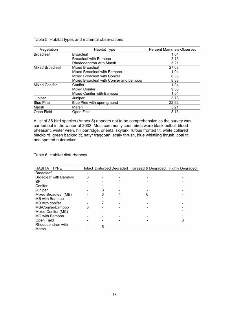
Table 5. Habitat types and mammal observations.
Vegetation Habitat Type Percent Mammals Observed Broadleaf Broadleaf 1.04 Broadleaf with Bamboo 3.13 Rhododendron with Marsh 5.21 Mixed Broadleaf Mixed Broadleaf 27.08 Mixed Broadleaf with Bamboo 1.04 Mixed Broadleaf with Conifer 8.33 Mixed Broadleaf with Conifer and bamboo 8.33 Mixed Conifer Conifer 1.04 Mixed Conifer 9.38 Mixed Conifer with Bamboo 1.04 Juniper Juniper 3.13 Blue Pine Blue Pine with open ground 22.92 Marsh Marsh 5.21 Open Field Open Field 3.13 A list of 88 bird species (Annex 5) appears not to be comprehensive as the survey was carried out in the winter of 2003. Most commonly seen birds were black bulbul, blood pheasant, winter wren, hill partridge, oriental skylark, rufous fronted tit, white collared blackbird, green backed tit, satyr tragopan, scaly thrush, blue whistling thrush, coal tit, and spotted nutcracker. Table 6. Habitat disturbances. HABITAT TYPE Intact Disturbed Degraded Grazed & Degraded Highly Degraded Broadleaf - 1 - - - Broadleaf with Bamboo 3 - - - - BP - - 4 - - Conifer - 1 - - - Juniper - 3 - - - Mixed Broadleaf (MB) - 3 4 6 - MB with Bamboo - 1 - - - MB with conifer - 7 - - - MB/Conifer/bamboo 8 - - - - Mixed Conifer (MC) - - - - 1 MC with Bamboo - - - - 1 Open Field - - - - 3 Rhododendron with Marsh
- 5 - - -

- 19 -
Chapter Six
SSPPEECCIIEESS OOFF CCOONNCCEERRNN
BLACK-NECKED CRANE The largest winter population of the Black-necked Crane (Grus nigricollis) in Bhutan, resides in the Phobjikha valley. Every winter, they arrive from the Tibet region of China. The cranes and humans are critically linked in Phobjikha. The crane population data from Phobjikha collected by RSPN since 1987, suggests that the winter population has gradually increased. In 1987, the population was 120 birds and in 2003, some 269 birds were reported (Fig. 10). Crane arrivals increased rapidly from 1992 – 95 and gradually from 2001 –2003. A 12 year time-series forecast model suggests that the wintering population of the Black-necked Cranes in Phobjikha is promising (Table 7). This model is perhaps more reliable than others because crane population data between 1987 – 2003 are not randomly scattered across the trend line. Figure 10. Wintering population of Black-necked Cranes in Phobjikha (1987 – 2003). The
horizontal line indicates a mean value of 186.47 with standard error 58.91.
100
125
150
175
200
225
250
CR
AN
ES
IN P
HO
BJI
KH
A V
ALL
EY
1986 1988 1990 1992 1994 1996 1998 2000 2002 2004
TIME (Year) Table 7. Time-series analysis of the wintering cranes in the Phobjikha valley (Pradhan et
al., 2004).
YEAR (TIME) PREDICTED POPULATION STD. ERROR UPPER CL LOWER CL
2006 258 37.09432 330.6926 185.2856 2008 252 45.64743 341.0053 162.0707 2010 246 51.57284 346.7986 144.6368 2012 240 55.9346 350.0963 130.8367

- 20 -
In Tibet, shallow wetland areas used by the cranes, often occur along lakes or in alpine meadow valleys fed by spring run offs. Similar situation prevails in the Phobjikha valley. However, crane habitats in the Phobjikha valley, are outcome of years of intensive farming as well as extensive cattle grazing. These crane habitats are further enhanced because of less human disturbance to the wintering cranes, when village households predominantly migrate to the warmer valley of Ada during winter. Farms are foraging areas for the wintering cranes, therefore, they are extremely important. Some 396 households from 46 villages reported that their farms get visited by the cranes during their foraging bouts. Their diet items while foraging in farms are of extremely important and a topical issue from conservation biology standpoint. They feed on the crop residues in the harvested fields where potato, wheat, barley and buckwheat had been planted earlier. They are also known to feed on insects and soft shoots and dwarf bamboo roots. Marsh areas have been classified into six sub-types because they are complex and contain five - succession stages.
1. Dry grassland. Dry land in marshy areas are raised where Agrostis inaequiglumis, Arundinella hookeri, Eragrostis nigra, Eragostis feruginea, several species of Festuca, Erigeron, Gnaphalium, Primula and Gentiana occur.
2. Marsh with vegetative Succession Type I. Marsh areas have 60% surface water
where cranes roost. The water level is more than 50 cm deep with the plants floating in it. The main species are Carex nigra, Juncus rara, Potamageton diticuts, Potamogeton berchtoldii and Utricularia.
3. Marsh with vegetative Succession Type II. Marsh areas have 50% surface
water. With spring water flowing freely, plant species composition includes Epilobium, Carex rara, Carex nigra, Ranunclus. Potentilla, Persicaria hydropiper, Lazula multiflora, and Eleocharis mitracarpa.
4. Marsh with vegetative Succession Type III. Marsh areas look like green pastures
with thick slush. The most common plant are Carex rara, Carex nigra, Primula denticulata, Ligularia, Juncus thomsonii, Tofieldia himalacia, Ophiopogon bodinieri, and Aletris grabra.
5. Marsh with Vegetative Succession Type IV. Two species of bamboos, Yushania
microphylla and Aurundinaria racemosa are dominant. Because of dense roots and bamboo culms, other plants are sparse.
6. Marsh with vegetative Succession Type V. Marshes have two species of
rhododendron: R. thomsoni, and R. virgatum. Other associates are bamboo (Yushania and Arundinaria), Rosa sericia, Cotoneaster microphylla, Salix, and Berberis.

- 21 -
TIGER Evidence of tigers at 3,331 m near the northeast slope of Gangkha including tiger scats (droppings) and remains of a wild pig kill, with abundant wildlife such as sambar, barking deer, jungle cat and wild pigs, are reported. Additional tiger scats are reported from Lamchuna at 3,091 m. Therefore, it is important to include all tiger habitats and ecological sensitive sites as critical forest of PLCA, where tigers from adjoining Jigme Dorji NP and Jigme Singye Wangchuck NP may overlap their home-range. Information from PRA, suggest that in many areas of PLCA, from where tigers were reported several years back, do not have any tigers in them or no reporting has occurred. As wild animals are outweighed by the cattle in both numbers and density in any given forest areas, probability of encountering more cattle than any prey species by large predators, is high. Given this fact, cattle depredation is natural. In recent past, perhaps tigers were deliberately eliminated as retribution because of enormous economic loss through cattle-lifting. Therefore, non-lethal control measures such as compensation schemes constitute a good strategy for information collection about tiger distribution and to avoid retribution. Such well-perceived arrangement may complement the zoning of PLCA. For example, any cattle killed by the tiger in the zone where cattle grazing is prohibited, may not be compensated. WHITE-BELLIED HERON The White-bellied Heron (Ardea insigniss) is one of the 50 rarest bird species in the world, which historically occurred in Nepal, India, Bangladesh, Myanmar and Bhutan. Its
population in the world is still unknown, although some 20 - 200 birds may exists globally. There is no information on its life history. A preliminary RSPN survey suggests three herons along the Pho chhu and Mo chhu. A nest was also found on a chirpine tree at 980 m elevation near a cliff along the river. This nest is the second record in the history of heron study in the world. Bhutan appears to have some 12 White-bellied Heron with over two adult birds from Ada of the PLCA. A full-length study is required on its life history and ecology to develop a management prescription for its long-term conservation in the PLCA.

- 22 -
Chapter Seven
VVIILLLLAAGGEESS AANNDD HHOOUUSSEEHHOOLLDD EECCOONNOOMMYY
HUMAN POPULATION In Phobjikha valley, there are 49 villages that support a population of 4,716 people in 498 households. Of which, 2,312 are male and 2,404 are female (Table 1,Source - Basic Health Unit, Phobjikha). Subsistence economy of the Phobjikha valley is attributed to large family size and less productive population including children. The active population of 15 – 49 year age group is 43.6% and children below the age group of 15, make 38.4% of the population. All these suggest that the population is both emergent and growing. Average family size is large with 7.5 persons and a range of 1 – 14 people (Fig. 11). Figure 11. Family size class and population.
0
20
40
60
80
100
1 2 3 4 5 6 7 8 9 10 11 12 13 14
Family Size Class
No
. o
f F
amil
y
0
100
200
300
400
500
600
Po
pu
lati
on
in
eac
h S
ize
Cla
ss
no. of family in each size class family size class population in each size class
LANDHOLDINGS Village communities in the valley are agrarian as all households rely on farming and livestock-rearing. Household possessions of landuse types include dry land (52.6%), wetland (24.9%), and sokshing (21.1%). Others are pasture (0.7%), and combination of dry land, wetland and sokshing (0.7%). Farmers primarily depend on dry land and supplement with wetland cultivation. Only three households do not have any farmland. Dry land holdings ranges from 0.12 – 6 acre per household with a mean of 1.8 acre, totaling 833.94 acre. When a normal distribution is considered, dry land farms amongst 462 households appear comparatively better than those of wetland farms (Fig. 12 and 13).

- 23 -
Figure 12. Distribution of dry land farm size and its normal distribution
Wetland farms lie in the lower warm valley, in Ada. Households from Gangtey and Bjena migrate to their wetland farms in lower valleys where ambient temperature is warm. They farm rice in summer, wheat and vegetable during winter. The range of wetland farm size was 0.06 – 10 acre with a mean value of 0.433 acre, totaling 200.83 acre. A few households are engaged in fuelwood collection and herd their cattle. As households from Phobji do not have access to wetland in lower valleys, they do not migrate. Distribution of wetland farms is skewed and 324 households do not have wetland farms. As subsistence farmers, having nothing to farm in the winter is difficult and their numbers are increasing. Figure 13. Wetland farm size and its exponential distribution.

- 24 -
FARM ECONOMICS Over 97% of the households are involved in farms and allied activities. Both agriculture and livestock are two main sources for household income (Table 8). In farms, potato, radish and wheat top all crops. Table 8. Sources of income.
SOURCES OF INCOME GEOG
ADA BJENA GANGTEY PHOBJI TOTAL Livestock 3 2 1 1 7 Agriculture 0 11 14 24 49 Agriculture./ Livestock 4 35 40 75 154 Small shop 0 0 0 1 1 Shop / Agriculture 0 0 0 3 3 Labor 2 1 3 0 6 Agriculture/Labor 7 6 24 26 63 Agriculture/ Livestock/Labor 0 16 52 108 176 Agriculture/ Govt. Service 0 0 0 1 1 NA 1 0 1 2 4
Total 17 71 135 240 464 As farms produce approximately 30% of the total potato production in Bhutan (Food Corporation of Bhutan, Phuntsholing, 2003), the Phobjikha valley has cash crop economics (Fig. 14). Given this, use of chemical fertilizer is significant. Potato-producing households use 106.43 tons of sulphate and 54.5 tons of urea (Fig. 15). Along with fertilizers, each household use 1.193 kg of pesticide (242 households) and 1.5 kg of herbicide (318 households), totaling 289 kg of pesticide and 470.5 kg of herbicide contributing to a higher yield . Incidence of usage of these chemicals may also increase in future. Conversely, 99 households use organic manure with a range of 180 –12,600 kg, along with fertilizers.

- 25 -
Figure 14. Farm size and potato yield.
R2 = 0.175
0
5000
10000
15000
20000
25000
30000
0 1 2 3 4 5 6
Dryland Farms (acre)
Po
tato
Yie
ld (
kg
)
The stability of existing pattern of distribution of both dry land and wetland farms will depend on the cash economy, rate of farmland fragmentation (as family members break away) and other forms of development. Resulting fragmentation of farms may bear habitat-related implications on endangered wildlife species especially the Black-necked Cranes because they feed predominantly in already harvested potato farmlands. Figure 15. Potato-yield and use of chemical fertilizer (Dorji et al., 2004).
R2 = 0.7494
0
5000
10000
15000
20000
25000
30000
1 19
37
55
73
91
10
9
12
7
14
5
16
3
18
1
19
9
21
7
23
5
25
3
27
1
28
9
30
7
32
5
34
3
36
1
37
9
39
7
41
5
43
3
45
1
Fertilizer (sulphala) (kg)
Po
tato
Pro
du
cti
on
(k
g)
LIVESTOCK Only four household do not have livestock. Yak, cows, horses, sheep, goat, pigs and poultry constitute livestock, with a total of over 3,800 animals. Cows number highest (1,830 animals) followed by sheep (1,200 animals) and horses (125 animals). Of 3,363 livestock, Gangphey, Gangtey, Moel and Tabding together constitute 52% of the

- 26 -
population. Livestock are stall fed, grazed in open areas (pastures) and wetland. Sources of fodder primarily come through farms (97%) and forest. FOREST RESOURCES AND WILDLIFE DEPREDATION Like anywhere else in the Himalayas, development costs are borne by forest resources. In Phobjikha, about 900 m3 of firewood was extracted in 1999 and 12,000 m3 in 2000 for the commercial purpose. All households use fuelwood to cook and heat their homes. Average fuelwood consumption is 31,158 kg (1,260 – 12,600 kg) and required annual fuelwood for all household is estimated to be 15,516.83 ton. Other non-timber forest resources used by 191 households include fodder for cattle, leaf manure, household utilities and as medicaments for many ailments (Table 9). Crop-raiding by wildlife was topped by deer and wild pigs with 97% reported. The Himalayan black bear is occasionally reported for crop-raiding activity. Livestock depredation was reported by 426 households. Top predators include leopard, wolf, fox and wild dog. Reporting of depredation by bears and tigers are minimal. When depredation occurs, loss of livestock is substantive for any given household. Table 9. Non-timber forest products. NON TIMBER FOREST PRODUCTS FREQUENCY PERCENT Ferns for cattle bedding 1 .2 Bamboo/cane 10 2.2 Dry leaves 13 2.8 Fern & dry leaves 141 30.4 Fern, dry leaves & bamboo 19 4.1 Mushrooms 23 5.0 Fern, dry leaves & mushroom 47 10.1 Fern, dry leaves, mushroom & bamboo 42 9.1 Fern, dry leaves, tsey, mushroom & bamboo 18 3.9 Bamboo/cane & Mushroom 11 2.4 Cordycep, Fern, dry leaves, mushroom & bamboo 1 .2 NA 273 58.8
Total 464 100.0 VILLAGE PRIORITIES Health, education and infrastructures are three exceptionally good indicators of rural development for mountain societies in Bhutan. There is one primary school, one community school, five non-formal education centers and one basic health unit. Equal proportions of boys and girls go for primary education. However, students make only 9.56% of the population. Health indicators like rate of neonatal death, infant mortality and maternal death have come down because of sanitation and health facility like BHU

- 27 -
with over 12 village health workers. All households have separate animal sheds, and outhouses (toilets). Some 291 households have rural water supply scheme. Nearly all households have radios and nearly 16% of households have power-operated tiller and tractor. In terms of infrastructure, motorable road link exists, technical support for farm produce from RNR Dzongkhag sector is available, and two telephone public booths exist. Some 28% of household received loan money and the three money-lending sources were ranked as BDFC, individuals and Bank of Bhutan, suggesting the valley population have already engaged in large scale potato production, driven by cash economy. Phobjikha may not represent a truly far-flung rural Bhutan, yet it faces many development issues including transport, electricity, communication and many others. In this regard, all households have a strong community interest in economic development than in any other societal issues. To realize conservation efforts in the valley, all development needs to be met on a step-wise basis as it is a delicate balance. For the next five year, the village development priorities identified by the 464 households were: 1) Building asphalt road from the national highway to Phobjikha; 2) Electricity in the Phobjikha valley; and 3) Building schools.

- 28 -
Chapter Eight
PPLLCCAA ZZOONNAATTIIOONN AANNDD RREEGGUULLAATTOORRYY FFRRAAMMEEWWOORRKK
BACKGROUND The legal framework as per the Nature Conservation Act 1995 and the Revised Forest and Nature Conservation Rules of Bhutan, 2003, is applicable for the protection of wildlife species in PLCA. Some variations in describing different zones are evident as most of the crane area is infused with human settlements and all pastures are extensively grazed which are beneficial to the cranes. Regulatory framework described here are in addition or supplementary to national Acts, Rules and Regulations. For the purpose of safeguarding existing biodiversity and to maintain integrity of the ecosystems, defining different management zones has become a priority to address a broad range of human-related activities including agriculture and activities connected with exploitation of wildlife, forest-related products and degradation of wetland. The objectives of developing the management zones are to develop ecologically and economically viable landuse whereby wildlife and their habitats are secured against any or all threats, and the needs of the resident communities are planned and executed in ways that they do not adversely affect the ecosystems of the PLCA. Therefore, zoning is prerequisite and PLCA is grouped into: 1) Critical wetland zone, 2) Critical forest and watershed zone, 3) Forest utility zone, and 4) Farms and settlement zone. CRITICAL WETLAND ZONE Wetlands in Phobjikha are critical not only for the cranes but also for the sustenance of the communities. All six habitat types of marsh will be mapped through ground survey and secured against any human-related disturbance or intrusion. Regulatory framework will include prohibition of following activities: a) any construction, including motor roads, buildings, fences, or any physical structures; b) settlement and cultivation; c) any research or excursion, except those contemplated by the Management Plan; d) taking wildlife of any kind and e) fishing. These are very similar to those regulations prescribed for the core zone of PAs. CRITICAL FOREST AND WATERSHED ZONE Mature forests are small and isolated because of human influence. They also safeguard critical watershed zone. The watershed is the source of constant water supply to the wetlands and farms throughout the year. Therefore, they will be identified and mapped

- 29 -
for conservation as they provide habitat to many rare and endangered species such as tiger, red panda and White-bellied Heron. Cattle grazing will not be allowed. No wildlife may be taken from this zone and taking of wildlife within any other zone may be permitted only in compliance with the conservation management plan. No person shall be in possession of any plant listed in the Schedule I of the Act, or any wild animal including live specimens, dead specimens, or any parts. In addition to the full protection of wildlife species listed in Schedule I of the Forest and Nature Conservation Act 1995, all other wild animals may not be killed, injured, destroyed, captured, collected, or otherwise taken, except in accordance with special authorization issued under the Forest and Nature Conservation Rules of Bhutan, 2003. Any person found indulging in the above mentioned prohibitory activities, shall be considered a felony. FOREST UTILITY ZONE Degraded forest patches, nearby settlements, open bamboo/grasslands and barren land provide an opportunity to improve the land with plantation and silvi-culture practices for sustained-yield fuelwood extraction and timber for house building. Also, these are potential areas for improved pasture management and grazing mechanisms. Regulations will include allowance to resident communities to collect dead wood, medicinal plants and non-woody plant products on a sustained – yield basis. Residents may graze domestic stock, and cut timber trees for construction with special permits from the management. No forest covers will be opened for agriculture, but existing fallow fields may be reopened for afforestation. Participatory forestry practices will be allowed and encouraged. FARMS AND SETTLEMENTS ZONE This zone constitutes the area between the critical wetland zone and the forest and critical watershed zone that is occupied by local farm houses and agricultural fields or unutilized government land. This is a zone of concentrated human activity and serves as a focus area for executing livelihood alternative programmes. MANAGEMENTGUIDELINES FOR UTILIZATION OF THE LAND
1. Land holding in the Phobjikha valley also relates Kidu, a traditional land-grant system whereby villagers for their hardship and family grievances are granted land that belongs to the state. Active management to preserve the integrity of the land and ecosystems entails that Kidu will have a serious and long-term impact as there are already 22 households with Kidu.
2. In the critical wetland zone, apart from existing houses and farms:

- 30 -
1) No additional land conversions to be allowed. In the event of private
registered land currently unutilized but deemed necessary for the crane habitat, can be taken over with compensation for the land either through a) payment or b) replacement from government land from unutilized government land in farming and settlements zone.
2) No clearance to be provided by DoF/ NEC/ Dzongkhag to Households/ Individuals seeking land under ‘Kidu’ from this zone.
3) No clearance to be provided by DoF/ NEC/ Dzongkhag to private firms/ government agencies for land from this zone except for the purpose of biodiversity conservation.
4) Grazing of livestock belonging to local community to be allowed as per traditional rights.
5) Public facilities such as roads/ trails that inevitably pass through this zone, should incorporate adequate planning to allow continuity in the wetland drainage.
6) No recreational facilities such as campsites and lodges may be placed inside this zone.
3. In the critical forest and watershed zone, little or no human influence is
prescribed. Therefore, year-round grazing is prohibited along with other activities that may threaten ecological intactness of the forest ecosystems.
4. In the forest utility zone, Territorial Forest Division of the Department of Forest
shall prescribe code of best practice in allocation of timber for rural households requirements including: 1) Households/ entities outside the conservation area are not eligible for timber
allocation from this zone. 2) No timber to be allocated from this zone to households for the purpose of
moving the same timber outside with exception of those registered households who have winter homes in areas outside PLCA.
3) FMU (forest management unit) without any logging purpose, in this zone shall demonstrate code of best practices for forest management such that the regeneration capacity of the zone is not undermined.
4) No extraction of timber to be permitted within 50 meters of all streams and rivers.
5. In farms and settlement zone, three parameters are of concern:
1) Use of chemical fertilizers/ pesticides that have maximum seepage into the
wetlands and those that are detrimental to the long term condition of soil will be monitored and controlled.
2) Effluents from existing and potential cottage industries/ hotels are subject to environmental monitoring and restriction under the EIA Act.

- 31 -
3) Households/ business entities are required to follow proper solid waste garbage management practices.
REGULATORY FRAMEWORK In accordance with the Nature Conservation Act 1995 and the Revised Forest and Nature Conservation Rules of Bhutan, 2003, RSPN will develop regulatory framework under the guidance of the Department of Forest of the Ministry of Agriculture, with an aim to achieve the practicals of managing the land under PLCA. Of many pertinent conservation-related objectives that will be included in the regulatory framework, extraction of timber and other NTFPs to meet household needs, require standard practice of silviculture in Bhutan. Such shall also address outbreak of diseases in forest ecosystems including trees and wildlife. Therefore, a science-based silviculture protocol will be developed in consultation with the territorial forest division. No commercial logging will be encouraged in the event FMUs occur in PLCA as it complements the biodiversity conservation function of two adjoining national parks and biological corridors. In the event that household fuel wood needs can not be met from the forest utility zone of PLCA, territorial forest may provide such from outside such as Gogona and Kothaka areas, until the time when plantations in the forest utility zone, are economically mature and viable. Likewise, forest-related revenue and law enforcement within PLCA will remain with the territorial forest division. ANNUAL ACTIVITIES
PROGRAM ACTIVITIES Y 1 Y 2 Y 3 Y 4 Y 5
1. Ground-truthing and demarcation of PLCA boundary 2. Consult with Geogs and other stakeholders on zone
demarcation
3. Demarcate Critical wetland Zone 4. Demarcate the Critical forest and watershed zone 5. Mapping of soksing,Tsmadrog and Tseree cultivation, if
any.
6. Consult with TFD and geogs on the demarcation of the Forest utility zone
7. Implementation of the management zone regulations 8. Familiarize with the biological corridors within PLCA 9. Publication of Management Plan in Dzongkha

- 32 -
Chapter Nine
NNaattuurree CCoonnsseerrvvaattiioonn
PROGRAM ACTIVITIES The objectives of nature conservation are to protect and maintain species and ecosystems with a focus to provide specific protection to endemic and endangered flora and fauna. The endangered species are tigers, Black-necked Cranes and White-bellied Heron. Therefore, conservation will be based on landuse approaches to protect a variety of ecosystems from wetlands to warm broadleaved forest and conifers. To maintain existing biodiversity, nature conservation program will encompass the following activities. CRITICAL WETLANDS
1. A detailed ecology of cranes will be conducted including their roosting and feeding sites. In the past, crane counts have been considered adequate but as the crane population is gradually increasing over the years, there is a need to know more about the governing factors that determines their winter population at temporal scale.
2. All six habitat types within critical wetlands will be developed as a register
including physical details (GPS location, origin, size and ecological characteristics). Furthermore, GIS based habitat maps will be prepared with analysis to delineate the critical wetland zone
3. In wetland zones, several permanent monitoring sites for both vegetation and
water quality will be established to determine vegetation succession and effect of pesticide and herbicide along with chemical fertilizer that are leached from farm soil.
TIGERS AND CRITICAL HABITATS
1. Monitoring protocol on the tiger population will be designed and developed with the help of the Tiger Program Unit of the NCD. Information on tiger population in the PLCA will assists the tiger conservation strategy, for which the management will collect all tiger-related data and information gathered through kill reports.
2. Adequate numbers of permanent vegetation plots in all forest types will be
established to monitor tiger movement, prey density, vegetation succession, dominance, regeneration and relevant ecological studies.

- 33 -
WHITE-BELLIED HERON
1. A full-length ecological study and survey will be conducted to acquire information for their protection and required management intervention. All ecological characteristics of their habitat will be evaluated to extrapolate potential habitats in PLCA.
2. A population monitoring protocol will be designed, developed and yearly
activities will be implemented.
ECOSYSTEM INFORMATION AND MONITORING
1. A rapid ecological survey will be completed in the entire area of PLCA to substantiate on how to address threats to biodiversity and monitor any changes in landuse pattern. This survey will use the methods prescribed earlier for the Phobjikha valley.
2. A GIS lab will be established and existing RSPN staff in Thimphu will be trained
in remote sensing and GIS. Database on vegetation, mammals and birds will be developed for the entire area, which can be updated or compared for the preparation of a new management plan, every five year after, beginning 20011.
3. Village forest guards (Resoops), the age-old tradition of Bhutan, has been
emphasized in several management plans. As the management involves both natural resources and resident communities, some aspects of the management and research are cross-sectoral because they are complex by nature and their utility. Therefore, they can create awareness through interaction with resident communities, and inform the management about livestock depredation and trends in crop damage incurred through wildlife.
4. Development of options to inhibit crop raiding by the edge-dwelling species,
especially the wild pigs, will be studied and recommendations will be implemented with information and support from NCD.
FUELWOOD AND FOREST UTILITY ZONE Fuelwood consumption for each village will be completed along with the source locations of fuelwood. Accordingly, biomass yield and fuelwood consumption will be matched through afforestation of degraded sites. All plans will be identified and prioritised based on the severity of fuel wood needs by village user groups. Nurseries will be established and technical know-how will be sought .

- 34 -
ANNUAL ACTIVITIES
PROGRAM ACTIVITIES Y 1 Y 2 Y 3 Y 4 Y 5 Black-necked Cranes and Critical Wetlands
1. Ecology of cranes 2. Habitat register 3. Wetland permanent monitoring sites
Tigers and Critical Habitats 1. Monitoring protocol on the tiger population 2. Permanent vegetation plots in all forest types
White-bellied Heron 1. Ecological study and survey 2. Population monitoring protocol
Ecosystem Information and Monitoring 1. Rapid ecological survey 2. GIS lab 3. Resoops 4. Development of options to inhibit crop raiding by wildlife
Fuelwood and Forest Utility Zone 1. Biomass yield and fuelwood Survey 2. Afforestation of degraded sites

- 35 -
Chapter Ten
EENNAABBLLIINNGG CCOOMMMMUUNNIITTIIEESS VILLAGES AND GEOG PLANNING In Bhutan, DYT (Dzongkhag Yargye Tshogchung), and GYT (Geog Yargye Tshogchung) are the two keys for livelihood and development. To expedite the planning process of PLCA, an inter-active management role for RSPN is required along with DYT and GYT. Therefore, village priorities can be realized through the PLCA management plan. The government’s five year plan of all four geogs, are considered as one of the guidelines for planning (Table 10). Table 10. Geog Ninth Plan. GEOG Geog Ninth Plan (2002 – 2007; SECTORAL PROGRMAS) Agriculture Livestock Health Education Road Forestry Athang Food Security Feed and
Fodder Outreach Clinics
Community School
Mule tracks ---
Rural Livelihood Backyard Farms
Rural Water
--- Suspension Bridge
---
Breed Outreach Clinics
Community Schools
Mule tracks ---
Bjena Horticulture Fodder Rural
Water --- Suspension
Bridges
Rural Livelihood Backyard Farms
--- --- --- ---
Breed --- --- --- --- Gangtey Food Security Breed Outreach
Clinics Community School
Suspension Bridges
Community Forestry
Income Generation Pasture Improvement
Rural Water
--- --- ---
Rural Livelihood --- --- --- --- --- Institutional/Capacity --- --- --- --- --- Rural Livelihood --- --- --- --- --- Phobji Food Security Income
Generation Outreach Clinics
Community School
--- Community Forestry
Income Generation Rural Livelihood
Rural Water
--- --- ---
Rural Livelihood --- --- --- --- --- Institutional/Capacity --- --- --- --- ---

- 36 -
MANAGEMENT STRUCTURE To expedite the planning process of PLCA, an inter-active, pro-management role for RSPN is required along with DYT (Dzongkhag Yargye Tshogchung), GYT (Geog Yargye Tshogchung), sectoral representative and local communities. Past experiences with the Phobjikha Conservation area Program Committee (PCAP Committee) suggest that coordinating group of people or securing community participation to implement program activities are inherently difficult. For example, project activities mobilized people in many conservation programs including making of nature trails, organizing the Black-neckedCrane festival, construction of the Crane Information Center and several others. PLCA will have its office in Phobjikha managed by seven-member staff and a field station in Ada managed by three – member staff. As PLCA spreads out in four geogs, each geog will constitute PLCA Geog Committee. Led by a nominated/elected chairman, the Geog Committee will have a representative from each village, three sectoral representatives and two representatives from PLCA Management. The committee’s primary function is to develop a five year plan to protect biodiversity and sustain the use of natural resources, minimizing any or all environmental degradations. GOVERNANCE From each PCA Geog Committees (four), the chairperson will represent the governing board of PLCA headed by the Executive Director of RSPN and member Secretary will be the manager of PLCA. Other ex-officious will be nominated from the Department of Forest, National Environment Commission and Dzongkhag Administration, totaling nine governing members. The member secretary will remain as non-voting member of the PLCA Governing Board. Dzongkhag planning and its implementation at the geog level are the two key steps for geog development. Therefore, if village priorities are to be realized through the PLCA management plan, then the Ninth Plan (2002 – 2007) of all four geogs, are to be considered thoroughly to complement them (Table 10). Such charting of priorities will lead to successful implementation of the management plan by RSPN because its principles are inherent to grass-root planning. PROGRAM ACTIVITIES
1. All PLCA Geog Committees require stakeholder consultation meeting on management rules and policies Institutional support, material development, extraction of environmental concepts from Buddhist text and their translation into Dzongkha, information dissemination program, observation tour and awareness program for their members. Also, training

- 37 -
for PLCA geog committee members are required in the areas of record and book keeping.
2. Community awareness on wetland – crane, and forest conservation
particularly relates to plantation, educational activities, field visits, development of audio-video materials, and meetings on environmental issues of Phobjikha.
3. Regarding ecotourism, RSPN efforts emphasize on the development of
specific ecotourism package that Phobjikha can offer to visitors. Once it is established, activities such as cook training, campsite management, and other can be organized to benefit local small entrepreneurs through tourism cooperatives that will function under the PLCA geog committee.
4. RSPN is presently working with the staff of the Primary School and the
three non-formal education centers at Phobjikha in assessing the education curriculum. In this regard, PLCA will develop materials that can complement the existing curriculum in conservation education.
5. In alternative energy sector, solar photovoltaic (SPV) electrification will
continue. However, Villagers’ need for rural electrification is justified and the Royal Government has a vision of “Electricity for all by 2020.” Given this scenario, PLCA will look for mitigative measures that will reduce the risk of harm to cranes and advise accordingly to benefit the community and their aspiration for development.
Annual activities
PROGRAM ACTIVITIES Y 1 Y 2 Y 3 Y 4 Y 5 PLCA Geog Committees Community activities and awareness Development of c ecotourism package & community activities Conservation education curriculum with emphasis on PLCA Crane Fly-way routes and mitigative measures on electric lines

- 38 -
Chapter Eleven
AADDMMIINNIISSTTRRAATTIIOONN STAFF STRUCTURE For implementation of the management plan, the PLCA will have the capacity for one conservation manager, four assistant managers, two public-relation experts and three caretaker, totaling 10 staff in the central office in Phobjikha and a field station in Ada. Considering human resource development, the conservation manager need a degree course education and four assistant managers need short 3 -6 month training in biodiversity and protected area management. FIELD STATION For the effective protection of biodiversity and overall management, a field station will be located at Ada. Besides the protection-related responsibilities under their jurisdiction, the staff will look after allied activities as well. They will be also responsible for the protection of the White-bellied Heron. At least, two resoops also will be appointed. STAFF RECRUITMENT
STAFF NUMBER Conservation Manager 1 Assistant Manager 4 Public-relation Expert 2 Care takers 3 Resoop* 2 Accountant* 1 Note: Provisional staff are indicated with * INFRASTRUCTUE DEVELOPMENT PLCA lacks infrastructure. To accomplish and facilitate the management plan, needed infrastructure will have to be built.
INFRASTRUCTURE Y1 Y2 Y 3 Y 4 Y5 Construction of central office Construction of field station in Ada Construction of staff quarters in Phobjikha Guest house at Phobjikha

- 39 -
Chapter Twelve
BBUUDDGGEETT DETAILS The budget plan for the period 2005 – 2007 is estimated at NU 45.5 million. The estimated budget for all planned activities comes under six subheadings. Of these, administration, nature conservation and human resource development hold major share of the estimated budget. Among the scheduled activities, construction and strengthening of the management of staff will gather momentum. Budget Abstract for Phobjikha Landscape Conservation
Particulars Year I
Year II Year III Year IV Year V Total
Management Cost 0.9 1.3 2.2
Nature Conservation 0.7 1.25 1.64 1.59 1.19 6.37
Enabling Communities 1.81 1.39 1.23 1.79 1.75 7.97
Infrastructure/furniture/vehicle 1.6 0.62 4.165 1.565 2.72 10.67 Administration Cost 2.572 2.895 3.28 3.3 3.32 14.49 Human Resource development 0.4 0.5 1.6 1 0.3 3.8 Total 8.12 7.87 11.605 8.935 8.97 45.5
Details of Management Cost (in Nu. Million)
Particulars Year I Year II Year III Year IV Year V Total
Ground-truthing/Boundary demarcation 0.2 0 0 0 0 0.2 Consultation meeting with local/other stakeholders 0.1 0.1 0 0 0 0.2 Critical wetland zone demarcation 0.1 0.2 0 0 0 0.3 Critical forest and watershed zone demarcation 0.1 0.2 0 0 0 0.3 Mapping 0.1 0.2 0 0 0 0.3 Consultation meeting on Forest Utility Zone with TDF/Geogs 0.1 0.2 0 0 0 0.3 Implementation of management zone regulations 0.1 0.2 0 0 0.3 Biolocical corridor familiarization within PLCA 0.1 0.2 0 0 0 0.3 Total 0.9 1.3 0 0 0 2.2

- 40 -
Details of Nature Conservation Cost (in Nu. Million) Particulars Year I Year II Year III Year IV Year V Total Black-necked Cranes and Critical Wetlands
Ecology of cranes 0.3 0.3 0.1 0.7
Habitat mapping 0.25 0.25 0.25 0.75
Permanent monitoring sites in the wetland 0.1 0.05 0.05 0.2
Tiger and Critical Habitats
Monitoring protocol on the tiger population 0.3 0.3 0.1 0.7 Permanent vegetation plots in all forest types 0.2 0.1 0.05 0.35 White-bellied Heron
Ecological study and survey 0.3 0.3 0.1 0.7
Population monitoring protocol 0.1 0.1 0.1 0.3
Ecosystem Information and Monitoring
Rapid ecological survey 0.1 0.1 0.1 0.3
Establishment of GIS lab 0.5 0.1 0.6
Recruitment of Resoops 0.09 0.09 0.09 0.27
Development of options to inhibit crop raiding by wildlife
0.1 0.2 0.3 0.6
Fuelwood and Forest Utility Zone Biomass yield and fuelwood survey 0.2 0.2 0 0.4
Afforestation of degraded sites 0 0 0.5 0.5
Total 0.7 1.25 1.64 1.59 1.19 6.37
Details of Annual Program Activity Cost (in Nu. Millions) Particulars Year I Year II Year III Year IV Year V Total
PLCA geog Committee meeting 0.4 0.3 0.3 0.2 0.2 1.4
Community activities and awareness 0.45 0.3 0.25 0.23 0.2 1.43 Development of ecotourism package & related community activities
0.5 0.3 0.2 0.1 0.1 1.2
Conservation education curriculum School Nature Clubs 0.1 0.1 0.1 0.3
Non-Formal Education Centers 0.06 0.06 0.06 0.04 0.03 0.25
Religious Institute 0.03 0.02 0.02 0.02 0.09
Local Community 0.3 0.3 0.3 0.2 0.2 1.3
Crane Fly-way routes and mitigative measures
1 1 2
Total 1.81 1.39 1.23 1.79 1.75 7.97

- 41 -
Details of Infrastructure Development Cost (in Nu. Million)
Particulars Year I Year II Year III Year IV Year V Total Infrastructure Construction of Central office 0 3.5 3.5 Construction of Field office in Ada 0 0 0.8 0.8 Construction of staff quarters in Phobjikha 0 0 2 2 Guest house at Phobjikha 0 0 0.6 0.6 Furniture 0 0.5 0.5 1 Telecommunications for Ada office 0.6 0.6 4WD Toyota Hilux 1.5 0 1.5 Purchase of two motor bikes 0.045 0.045 0.09 Maintenance of vehicles 0.1 0.12 0.12 0.12 0.12 0.58 Total 1.6 0.62 4.165 1.565 2.72 10.67
Details of Administration Cost (in Nu. Million) Particulars Year I Year II Year III Year IV Year V Total
Pay and allowances 1.60 1.62 1.64 1.66 1.68 8.2 Travel allowances 0.85 0.9 1 1 1 4.75 Utilities 0.08 0.09 0.1 0.1 0.1 0.47 Supplies and materials 0.1 0.12 0.15 0.15 0.15 0.67 Operational expenses 0.08 0.08 0.08 0.08 0.08 0.4 Total 2.71 2.81 2.97 2.99 3.01 14.49
Details of Human Resource Development Cost (in Nu. Million) Particulars Year I Year II Year III Year IV Year V Total
Degree level course for Conservation Manager 1.6 0 1.6 Short term course for Assistant Manager (4-6 months) 0.9 0.9 1.8 Refresher course for PLCA committee 0.3 0.2 0.2 0.7 Regional tour 0.4 0.4 0.8 Nature Club Environment Awareness 0.1 0.1 0.1 0.1 0.1 0.5 Total 0.4 0.5 1.6 1 0.3 5.4

- 42 -
REFERENCES
Dorji, L. 2004. Phobjikha Conservation Area: Preliminary Guidelines for Land
Management. RSPN Report. Thimphu, Bhutan. Dorji, L., Yonzon, P. and Tshering, D. 2004. Socioeconomic status of the Phobjikha
Landscape Conservation. RSPN. Thimphu. MoA. 2002. Biodiversity Action Plan for Bhutan 2002. Ministry of Agriculture. Royal
Government of Bhutan. Thimphu. National Statistical Bureau. 2004. Statistical Yearbook of Bhutan 2003. Royal
Government of Bhutan. Thimphu. NCD (Nature Conservation Division). 2004. Bhutan Biological Conservation Complex.
Department of Forestry Services. Ministry of Agriculture. Royal Government of Bhutan. Thimphu.
Penjor, U. 2001 Socioeconomic Survey of Phobjikha valley. Department of Geography
and Planning. Sherubtse College, Kanglung, Bhutan. Pradhan, R. , Yonzon, P., and Tshering, D. 2004. Ecology of the Phobjikha valley.
RSPN. Thimphu RGoB. 2002. Athang Geog Ninth Plan. Wangdue Phodrang Dzongkhag. Wangdue,
Bhutan. RGoB. 2002. Bjena Geog Ninth Plan. Wangdue Phodrang Dzongkhag. Wangdue,
Bhutan. RGoB. 2002. Gangtey Geog Ninth Plan. Wangdue Phodrang Dzongkhag. Wangdue,
Bhutan. RGoB. 2002. Phobji Geog Ninth Plan. Wangdue Phodrang Dzongkhag. Wangdue,
Bhutan. Tshering, D. 2004. Village and community appraisals in Phobjikha Landscape
Conservation. Draft Report. RSPN, Thimphu.

- 43 -
Annex One: Tree Species
FAMILY SPECIES Aceraceae Acer campbellii Acer caudatum Acer pectinatum Acer sikkimensis Acer sterculiaceum Aquifoliaceae Ilex dipyrena Araliaceae Gamblea ciliata Araliaceae Pantapanax sp. (unid) Pentapanax fragrans Betulaceae Betula utilis Corylus ferox Caprifoliaceae Vibernum mullaha Cupressaceae Juniperus recurva Juniperusus pseudosabina Juniperusus recurva Juniperusus sp. (unid 2) Juniperusus sp.(unid 1) Daphniphyllaceae Daphniphyllum himalensis Ericaceae Enkianthus deflexus Lyonia ovolifolia Rhododendron arboreum Rhododendron barbatum Rhododendron campylocarpum Rhododendron cinnabarinum Rhododendron griffithianum Rhododendron hodgsonii Rhododendron kesangiae Rhododendron keysii Fagaceae Quercus griffithii Quercus oxyodon Quercus semicarpifolia Fagaceae Quercus thomsoniana Hydrangeaceae Hydrangea heteromalla Lauraceae Lindera heterophylla Lindera neesiana Persea fructifera Magnoliaceae Magnolia campbellii Myrsinaceae Rapanea capitellata Oleaceae Osmanthus suavis Pinaceae Abies densa Picea spinulosa Pinus wallichiana Tsuga dumosa Rosaceae Prunus cornuta

- 44 -
Prunus nepalensis Prunus rufa Sorbus arachnoidea Sorbus microphylla Sorbus sp. (unid) Sorbus thibetica Symplocaceae Symplocos dryophila Symplocos glomerata Symplocos lucida Symplocos paniculata Taxaceae Taxus baccata

- 45 -
Annex Two: Shrub Species FAMILY SPECIES Actinidaceae Actinidia calosa Araliaceae Pentapanax racemosus Araliaceae Pentapanax fragrans Araliaceae Pentapanax fragrans Berberidaceae Berberis aristata Berberidaceae Berberis cooperi Berberidaceae Berberis insignis Berberidaceae Berberis aristata Buxacaceae Sarcococa hookeriana Caprifoliaceae Leycesteria formosa Caprifoliaceae Lonicera acuminata Caprifoliaceae Lonicera lanceolata Caprifoliaceae Lonicera myrtillus Caprifoliaceae Viburnium mullaha Celastraceae Euonymus elongatus Celastraceae Euonymus frigidus var.elongatus Celastraceae Euonymus grandiflorus Euonymus longiflora Toricellia tiliifolia Elaeagnaceae Elaeagnus parvifolia Ericaceae Agapetes hookeri Enkianthus deflexus Gaultheria nummularioides Gautheria semi-infera Vaccinium retusum Vaccinium sikkimense Gentianaceae Crowfordia speciosa
Grossulariaceae Ribes acuminatum Hydrangeaceae Hydrangea heteromalla Hypericaceae Hypericum choisianum Hypericaceae Hypericum elodeoides Lardizabalaceae Holboellia latifolia Leguminosae Piptanthus nepalensis
Loranthaceae Taxillus kaempferi Myrsinaceae Rapanea capitellata Oleaceae Jasminum humile Ranunculaceae Clematis montana Rosaceae Rosa sericea Neillia thyrsiflora Cotoneaster bacillaris Cotoneaster microphylla Rosa sericea Rubus alexeterius Rubus fockeanus

- 46 -
Rubus splendidissimus Rubus treutleri Rubus wardii Rubus thomsonii Spirea arcuata Spirea bella Rutaceae Skkimia laureola Toddalia asiatica Shisandraceae Schisandra grandiflora Smilacaceae Smilax elegans Smilax menispermoidea
Smilax ferox Smilax minutiflora Smilax myrtillus Thymelaeaceae Daphne bholua

- 47 -
Annex Three: Seedlings
F AMILY SPECIES
Aceraceae Acer campbellii Acer cappadocicum Acer pectinatum Acer caudatum Aquifoliaceae Ilex crenata Ilex dipyrena Ilex macropoda Ilex crenata Araliaceae Aralia cachemirica Gamblea ciliata Hedera nepaulensis Betulaceae Betula utilis Cupressaceae Juniperus squamata Juniperus recurva Ericaceae Lyonia ovaliferia Rhododendron arboreum Rhododendron barbatum Rhododendron campylocarpum Rhododendron cilliatum Rhododendron cinnabarium Rhododendron griffithii Rhododendron hodgsonii Rhododendron kesangiae Rhododendron keysii Rhododendron lanatum Rhododendron lepidotum Rhododendron thomsonii Rhododendron wightii Vaccinium nummularia Fagaceae Quercus glauca Quercus semicarpifolia Fagaceae Quercus thomsonii Lauraceae Lindera heterophylla Lindera neesiana Lindera pulcherrima Persea fructifera Magnoliaceae Magnolia campbellii Moraceae Ficus pubigera Oleaceae Ligustrum confusum Osmanthus suavis Pinacae Pinus wallichaina Abies densa Piceae spinolosa

- 48 -
Pinus wallichaina Tsuga dumosa Rosaceae Prunus nepalensis
Prunus rufa Prunus cornuta Sorbus arachnoidea Sorbus microphylla Sorbus thibetica Symplocaceae Symplocos lucida Theaceae Eurya cavinervis

- 49 -
Annex Four: Herb Species
FAMILY SPECIES Acanthaceae Strobilanthes oligocephala Strobilanthus oligocephala Acanthaceae Stobilanthus sp Acanthaceae Strobilanthus (G983) Strobilanthes sp. Balsaminaceae Impatiens dipyrena Impatiens discolor Impatiens stenantha Caprifoliaceae Sambucus adnata Caryophyllaceae Spergula arvensis Commelinaceae Cyanotis vaga Compositae Ainsliaea aptera Ainsliaea latifolia Anaphalis busua Anaphalis contorta Anaphalis cooperi Anaphalis sp Anaphalis triplinervis Artemesia vulgaris Artemisia moorcroftiana Aster albescens Carpesium nepalense Cirsium falconeri Euparorium mairei Picris hieracioides Senecio diversifolia Senecio raphanifolius Senecio scandense Senecio wallichii Synotis acuminata Synotis wallichii Convallariaceae Ophiopogon bodinieri Ophiopogon clarckii Convallariaceae Maianthemum fuscum Ophiopogon wallichianus Cruciferae Thlaspi andersonii Cyperaceae Carex nubigena Carex nubigena Carex rara Cyperus cyperoides Cyperus myoserus Cyperus squarrossus Frimbristylis complanata Isolepis setaceae

- 50 -
Kyllinga brevifolia Droceraceae Drocera peltata Ericaceae Chimaphila japonica Gaultheria semi-infera Vaccinium glauco-album Fumariaceae Corydalis latfolia Gentianaceae Gentiana capitata Helenia elliptica Swertia bimaculata Geraniaceae Geranium nepalense Geranium polyanthes Geranium procurrens Gesneriaceae Corallodiscus cooperi Gramineae Agrostis micrantha Agrostis nervosa Agrostis petelotii Arundinaria racemosa Arundinella bengalensis Arundinella hookeri Blymus compressus Borinda grossa Gramineae Brachypodium sylvaticum Calamagrostis emodensis Calamagrostis lahulensis Calamagrostis scabrescens Deschampesia cespitosa Elymus sikkimensis Eragrostis ferruginea Eragrostis nigra Eragrostis nubigena Eragrostis nigra Eulalia quadrinervis Festuca leptopogon Festuca polycolea Festuca rubra Festuca stapfii Muhlenbergia himalayensis Poa annua Poa rajbhandarii Sataria palmifolia Sporobolus fertilis Thamnocalamus spathiflorus Yushania microphylla Guttiferae Hypericum choisianum Juncaceae Juncus brachystigma Juncus grisebachii Pycreus flavidus

- 51 -
Labiatae Ajuga lobata Ajuga vulgaris Elsholtzia ciliata Elsholtzia densa Labiatae sp nov. Origanum vulgaris Stachys scaberula Gramineae Parochetus communis Gramineae Trifolium repens Liliceae Northolirion bulbuliferum Melanthiaceae Aletris pauciflora Orchidaceae Bulbophyllum rolfei Cephalanthera longifolia Chusua nana Gymnadeia orchidis Hebenaria intermidia Hebenaria sp Ione bicolor Zeuxine goodyeroides Orobanchaceae Orobanche solmsii Oxalidaceae Oxalis corniculata Papavaraceae Cathcartia villosa Piperaceae Piper suipigua Plantaginaceae Plantago erosa Polygonaceae Aconogonum molle Bistorta miacrophylla Polygonatum hookeri Polygonatum kansuense Polygonatum verticillatum Polygonium nepalensis Primulaceae Bryocarpum himalaica Lysimachia prolifera Primula denticulata Rannunculaceae Aconitum laciniatum Clematis buchananiana Clematis montana Thalictrum chelidonii Thalictrum foetidum Rosaceae Fragania nubicola Potentilla arbuscula Potentilla sp Rubus alexeterius Rosaceae Rubus calycinus Rubus wardii Rubiaceae Galium aparine Galium elegans Galium hoffmeisteri

- 52 -
Galium sikkimense Rubia manjit Saxifragaceae Saxifraga brunonis Saxifraga filicaulis Scrophulariaceae Hemifragma heterophyllum Pedicularis sp1 Pedicularis sp2 Rhynchoglossum obliquum Veronica himalensis Smilacaceae Smilax ferox Trilliaceae Paris polyphylla Umbelliferae Acrinema bellum Centella asiatica Cortia depressa Oenanthe hookeri Sanicula elata Urticaceae Elatostema grandidentatum Elatostema pusillum Elatostema sessile Laportea terminalis Pilea symmeria Violaceae Viola biflora Viola bulbosa Viola pilosa Zingiberaceae Roscoea alpina Pteridophytes Aspidiaceae Polystichium nepalense Aspidiaceae Polystichium spA Aspidiaceae Polystichium spB Polystichium spC Polystichum spD Polystichum spE Aspleniaceae Anisocampium (G962) Aspleniaceae Asplenium frimbriatum Dennstaediaceae Dennstaedtia scarba Pteridium aquilinum Pteridium spa Pteridium spb Sphenomeris chinensis Dryopteridaceae Cyrtomium sp2 Dryopteris cochleata Dryopteris palacecea Dryopteris sp1 Fern Fern sp28 Fern (G925) Fern OOO

- 53 -
Fern sp 1 Fern sp10 Fern sp11 Fern sp12 Fern sp13 Fern sp14 Fern sp15 Fern sp16 Fern sp17 Fern sp18 Fern sp19 Fern sp20 Fern sp21 Fern sp22 Fern sp23 Fern sp24 Fern Fern sp25 Fern sp26 Fern sp3 Fern sp4 Fern sp5 Fern sp6 Fern sp7 Fern sp8 Fern sp9 Fern sp27 Hymenophyllaceae Crepidomanes insigne Hymenophyllum dilatatum Lycopodiaceae Lycopodium clavatum Lycopodium complanatum Oleandraceae Oleandra wallichii Ophioglossaceae Botrychium lunaria Botrychium sp1 Osmundaceae Osmunda japonica Osmunda regalis Plagiogyriaceae Plagiogyra pycnophylla Polypodiaceae Drynaria G658 Drynaria propinqua Dryopteris pulvinulifera Lepisorus loriformis Loxogramme involuta Microgramma lycopodioides Microgramma lycopodioides Polypodium lachnopus Polypodium sp 1 Polypodium sp2 Pteridaceae Pteris biaurita

- 54 -
Pteris cretica Selaginaceae Selaginella involvens Thelypteridaceae Thelypteris erubescens Vittariaceae Vittaria elongata Bryophytes Moss (G940) Moss sp1 Moss sp10 Moss sp11 Moss sp12 Moss sp13 Moss sp2 Moss sp3 Moss sp4 Moss sp5 Moss sp6 Moss sp7 Moss sp8 Moss sp9 Spagnum sp14 Spagnum sp15 Spagnum moss sp16 Spagnum moss sp17 Spagnum moss sp18 Fungi Blue fungus Fungus mushroom sp Lichens Usnea langoflea Lichen Lichen

- 55 -
Annex Five: A Preliminary Checklist of Birds. SCIENTIFIC NAME COMMON NAME Prunella collaris Alpine Accenter Paradoxornis nipalensis Black throated parrotbill Phoenicurus frontalis Blue fronted redstart Cinclidium frontale Blue fronted Robin Bradypterus luteoventris Brown Bush Warbler Paradoxornis unicolor Brown parrotbill Tesia castaneocoronata Chestnut headed Tesia Glacucidium brodiei Collared owlet Carpodacus nipalensis Dark breastd rosefinch Turdus ruficollis Dark throated thrush Falco subbuteo Eurasian hobby Scolopax rusticola Eurasian Woodcock Dicaeum ignipectus Fire-breasted flowerpecker Parus dichrous Grey creasted tit Seicercus xanthoschstos Grey hooded Warbler Turdus boulboul Grey-winged Blackbird Actinodura nipalensis Hoary-throated Barwing Phoenicurus hodgsoni Hodgson's Redstart Upupa epops Hoopoe Lophura leucomelanos Kalij Pheasant Phylloscopus reguloides Large billed Leaf Warbler Emberiza pusilla Little bunting Zoothera dixoni Long tailed thrush Pericrocotus brevirostris Long-tailed minivet Spizaetus nipalensis Mountain hawk eagle Anthus hodgsoni Olive-backed pipit Streptopelia orientalis Oriental turtle Dove Falco peregrinus Peregrine falcon Muscicapella hodgsoni Pigmy Blue Flycatcher Leucosticte nemoricola Plain Mountain Finch Pyrrhocorax pyrrhocorax Red billed chough Leiothrix lutea Red billed leiothrix Aegithalos iouschistos Roufous fronted tit Niltava sundara Rufous bellied niltava Tarsiger hyperythrus Rufous brasted bush Robin Heterophasia capistrata Rufous Sibia Certhia nipalensis Rusty flanked treecreeper Pericrocotus brevirostris Short billed Minivet Columba leuconota Snow pigeon Coulmba hodgsonii Speckled wood pigeon Bradypterus thoracicus Spotted bush warbler Enicurcus maculatus Spotted forktail Garrulax ocellatus Spotted Laughingthrush Aquila nipalensis Steppe Eagle Yuhina gularis Stripe throated yuhina Yuhina flavicollis Whiskered Yuhina

- 56 -
Sitta himalayensis White tailed Nuthatch
Garrulax albogularis White throated
Laughingthrush Mycerobas carnipes White winged grosbeak Gallinago nemoricola Wood snipe
Rhipidura hypoxantha Yellow bellied Fantailed
Flycatcher Urocissa flavirostris Yellow billed blue magpie Sylviparus modestus Yellow-browed tit Ictinaetus malayensis Black Eagle Grus nigricollis Black -necked Crane Anthus godlewskii Blyth's pipit Alcippe ludlowi Brown throated fulvetta Anas crecca Common Teal Lanius tephronotus Grey backed shrike Circus cyaneus Hen Harrier Gyps himalayensis Himalayan Griffon Streptopelia orientalis Oriental Turtle Dove Cyornis poliogenys Pale chinened Flycatcher Tadorna ferruginea Ruddy Shelduck Dendrocopos hyperythrus Rufous bellied woodpecker Prunella strophiata Rufous breasted Accenter Prunella strophiata Rufous breasted accenter Phylloscopus affinis Tickell's leaf warbler Strix aluco Twany owl Garrulax affinis Black faced Laughing ThrushMycerobas affinis Collared grosbeak Yuhina occipitalis Rufous vented yuhina Alcippe vinipectus White browed fulvetta Chaimarrornis leucocephalus White capped redstart Hypsipetes leucocephalus Black bulbul Ithaginis creuentus Blood Pheasant Troglodytes troglodytes Winter wren Arborophila torqueola Hill partridge Alauda gulgula Oriental Skylark Aegithalos iouschistos Rufous fronted tit Turdus albocinctus White colored Blackbird Parus monticolus Green backed tit Tragopan satyra Satyr tragopan Zoothera dauma Scaly thrush Myophonus caeruleus Blue Whistling Thrush Parus ater Coal tit Nucifraga caryocatactes Spotted Nutcracker

- 57 -