magnasoft application development servicesapplication development … deve… · ·...
TRANSCRIPT

Seamless
System
Integration
System
Design
Data
capture and
Loading
System
Development
System
Testing
System
study
Seamless
System
Integration
System
Design
Data
capture and
Loading
System
Development
System
Testing
System
study
US Office Magnasoft Spatial Services Inc.
Suite 580, 2696 S. Colorado
Blvd, Denver, CO 80222.
Ph: +1 303 300 4840. Fax: +1
303 484 2043
Corporate Office Magnasoft Consulting India (P) Ltd
33/1 Lalbagh Road, Bangalore 560 027
Ph: +91 80 2222 7581-84. Fax: +91 80
22227580
UK Office Magnasoft Europe Ltd.
Second Floor, 8 Elder Street,
London E1 6BT
Ph: +44 207 377 9322. Fax:
+44 2073779272
MagnasoftMagnasoftMagnasoftMagnasoft
Application Development ServicesApplication Development ServicesApplication Development ServicesApplication Development Services

2
INDEX
1. MAGNASOFT BACKGROUND & QUALIFICATION................................................ 3
2. OUR BUSINESS PHILOSOPHY........................................................................... 4
3. MANAGEMENT TEAM AND QUALITY.................................................................. 4
4. MAGNASOFT’S QUALIFICATIONS AND EXPERIENCE......................................... 5
4.1 SERVICES................................................................................................... 5
4.2 DOMAIN & TECHNOLOGY EXPERTISE .............................................................. 7
4.3 STAFFING AND PROFILES .............................................................................. 8
5. INFRASTRUCTURE........................................................................................... 10
6. SELECT PROJECT CASE STUDIES ................................................................. 11

3
1. Magnasoft Background & Qualification
About Magnasoft
Magnasoft is a focused GIS software solutions company with innovative offerings having
strategic partnerships with industry leaders in the global space. Innovation is the guiding
force for all our services.
Magnasoft offers services ranging from application development to enterprise integration
and consulting to data conversion and capture. We even undertake field survey and
enterprise system integration projects, with our strategic partners. Our vertical focus is in
the following industries.
• Utility
• Oil & Gas
• Land Administration
• Geological Mapping
• Transportation
• Location Based services
• Engineering Services
Magnasoft has successfully implemented large projects for Fortune 500 companies and
government organizations. We use standardized business practices, coupled with
software engineering processes, in all our ventures.
A few of our reputed clientele include
4PSOMAS4Tadpole4OGI4City of Baltimore4ATS4Jacksonville Electric Authority
4CenterPoint Energy4OneGIS4Pixxures 4S&B Infrastructure4 Speed Up
Mobile4Groupe FIT4SCE4Bangalore Development Authority 4Chambre-de-
Commerce-et-D’Industrie-de-Lille Métropole4Karnataka Housing Board and many
similar companies.

4
Software
Partner
Business Partner
Long term
Projects
Joint Venture equity
participation
Strategic
Outsourcing
Tactical Outsourcing
Pilot
Projects
Premier Outsourcing
Partner
2. Our Business Philosophy
We project our commitment as follows:
• A premier “Low-Risk High Value Provider”
• We partner with industry leaders to deliver quality services to our esteemed clients
• We invest time and resources to consistently improve our project delivery
• We follow ISO guidelines in enterprise wide business processes
3. Management Team and Quality
Management Team Magnasoft’s Board of Directors bring together a team of technology, business, and
social visionaries who provide direction to the company’s executive management in a
dynamic economic and business environment. Magnasoft is mentored by Global
Technology Ventures, a premier venture capital company promoted by Bank of
America’s investment arm Nomura and Sivan Securities.
Quality
Quality Policy - “Convergence of minds, processes and efforts resulting in
benchmarked quality products and services ensuring customer delight”
Our commitment to the services offered is based on Quality, right from Strategy to
Implementation. Magnasoft is an ISO 9001:2000 certified company and is currently
pursuing SEI-CMM Level certification for all departments including Business
Management, System Development & Integration, Human Resource, Finance,
Administration and Process Management.
5
4. Magnasoft’s Qualifications and Experience
4.1 Services
Magnasoft offers a gamut of value added services in the field of GIS which includes GIS
Application development project lifecycle.
CONSULTING
• Requirement Analysis (Organization, Hardware, Software, Data and
Applications)
• Cost-Benefit Analysis
• Strategic Planning
• Feasibility Study
• Database and Application Evaluation
• Preparation of Implementation Plan
• Beta Testing
• Design and Conceptualization of solutions.
Prototype development
As a proof of concept developed from Consultancy studies or requirements provided by
the client, Magnasoft can take up the development of a prototype at a rapid pace.
DATABASE AND APPLICATION DESIGN
• Existing System Evaluation (Hardware, Software, Data and Applications)
• Database, Application, Hardware, Software, and Communication Network
• GIS/GPS Integration
APPLICATION DEVELOPMENT & MIGRATION SERVICES
Magnasoft builds custom applications based on specific needs and complexity of
requirements. We invest time in understanding client requirements, and then develop
tailor complete solutions that deliver tangible value to the enterprise. We consider every
aspect of the problem - from the underlying business processes to the importance of
change management and merits of various technologies. We then develop unique

6
spatial information systems that move client businesses forward and yield a measurable
return on investment.
GIS SYSTEM INTEGRATION
Magnasoft is capable of integrating GIS services starting from preparing needs
assessment to develop the GIS applications and training the users. Magnasoft offers the
following integration services.
• GIS Integration with workflow and messaging systems
• GIS Integration with back-end databases and legacy systems
• Internet and Intranet solutions
• Integration with imaging and document management systems
• Integration with visualization and modeling systems
• Integration with GPS systems
• SCADA
WEB GIS
Magnasoft has developed user specific Intranet/Internet GIS applications on ArcGIS
Server, ArcIMS and MapGuide, for transportation & mobile asset management, utilities
and network planning and land administration.
IMPLEMENTATION SERVICES
• Application testing
• System installation and testing
• Hosting Web Services and maintenance

7
4.2 Domain & Technology Expertise
Magnasoft Technology Expertise
GIS Technology Domains
Photogrammetry Leica Photogrammetry Suite, ORIMA, TE & ATE
Orthophoto ERDAS Imagine, Leica MosaicPro, Adobe Photoshop
LiDAR TerraScan, TerraModeler
ESRI ArcGIS Desktop & Server, ArcIMS, ArcSDE, ArcFM, ArcPad, MapObjects, OriginGIS,
AutoDesk AutoDesk Map, AutoDesk Mapguide, AutoDesk Civil/Survey, AutoDesk Land Desktop
Bentley Microstation J, Microstation Geographics
MapInfo MapInfo Extreme, MapInfo Professional
Database
Microsoft SQL Server, Access
Oracle Oracle 9, Oracle Spatial 10g
Utility
Transportation
Land administration
Geological mapping
Location Based Services
Development Environment
.NET, ArcObjects, VB, VC++, J2EE, Map X, MapBasic, VB Script, PHP, Cold fusion, Avenue Etc.
8
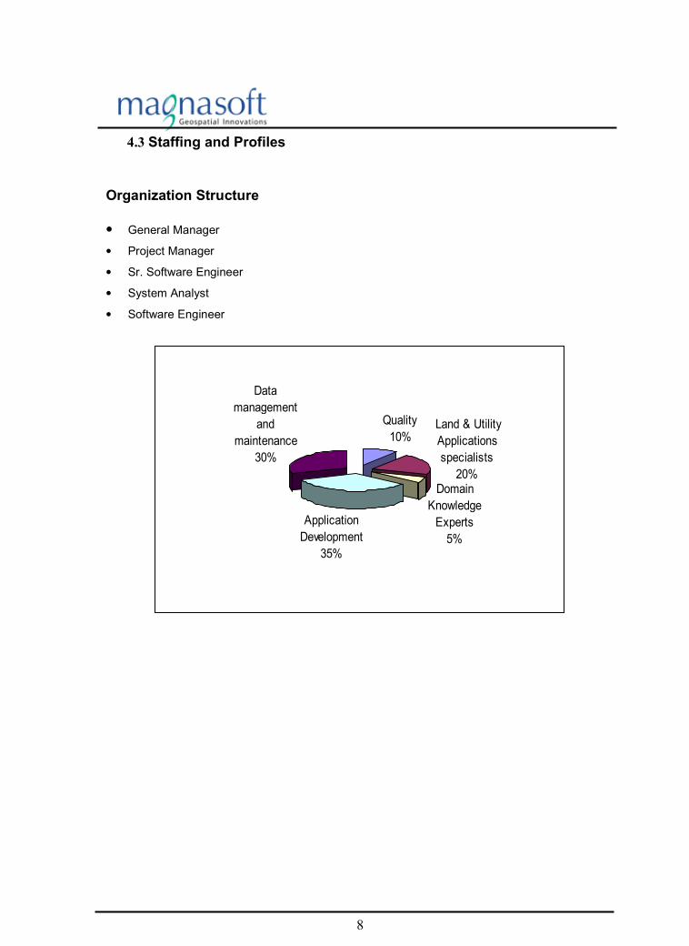
4.3 Staffing and Profiles
Organization Structure
• General Manager
• Project Manager
• Sr. Software Engineer
• System Analyst
• Software Engineer
Quality
10% Land & Utility
Applications
specialists
20%Domain
Knowledge
Experts
5%
Application
Development
35%
Data
management
and
maintenance
30%

9
Experience summary of Key personnel
•
MS - 0004 is working with Magnasoft as a Senior Consultant. He has commanding experience
in GIS and IT industry supporting Healthcare Management and Office Automation with
exposure to complete Software Development Life Cycle (SDLC). He has developed and
maintained GIS based applications in domains like Utility and Landbase Information Systems.
Also, he worked on satellite imagery interpretation, Aerial photo interpretation, image
processing, 3D modeling and GIS mapping using IDRISI and AutoCAD.
CAPABILITIES
• RDBMS - Oracle 9.x, Informix Dynamic Server 9.x, Microsoft
SQL Server 2005, Access 2003 (Including VBA
Customization), PL/SQL Scripting and ArcXML.
• GIS Applications - ArcObjects, ArcGIS 9.1, ArcGIS Server, ArcGIS
Engine, MapObjects, ArcIMS 4.0 and ArcSDE
• Development Environment - .NET framework, InstallShield 10.0 and Visual
Studio 6.0
• Programming Languages - Visual C# .Net, Visual Basic, Visual Basic .Net,
Java (JSP, Servlets, JDBC, Applets and AWT),
Avenue, VC++ Active Template Library and
Interface Definition Language.
• Support/Design Tools - Crystal Reports 9 Report Designer Component API
using VC++ and JNI, Microsoft Visio 2000 and
System Architect
• Scripting Tools - JavaScript and InstallShield scripting
• Source Control Tools - Visual Source Safe, Code Co-op and Perforce
• Operating Systems - Windows XP, 2000, NT, 95/98
MS - 0147 is working with Magnasoft as a Senior Consultant. His key strengths are in
managing large GIS, GPS based IT projects for cross country pipeline, electric distribution
network, parcel mapping in public sector enterprises and government agencies. His key
functions include managing, development and implementation of GIS client-server software
applications using ESRI and Microsoft Technologies, to use data models like ArcGIS Pipeline
Data Model (APDM), Pipeline Open Data Standard (PODS), ArcGIS Electrical Distribution,
MultiSpeak, ArcGIS Water Utilities, for database development and provide customized
functionalities to analyze, query and update data.
CAPABILITIES
• RDBMS - Oracle 9i, SQL Server, MS Access
• GIS Applications - ArcGIS, ArcGIS 3D Analyst, ArcObjects, ArcSDE,
Map Objects Window Edition, ArcPad, MapInfo,
Mapbasic and Autodesk Map 2004
• Development Environment - .NET framework, Visual Studio
• Programming Languages - ASP, C#, Visual Basic 6.0 and XML/XSL
• Support/Design Tools - Crystal Reports, IIS, Visio and UML
• Data Models - APDM, PODS (Cross Country Pipeline)
• Operating Systems - Windows XP, 2000, NT, 95/98

10
5. Infrastructure
Magnasoft’s operations are housed in a stand-alone 20,000 square feet multi-storey
building in the heart of Bangalore City, India. The world-class facility houses Magnasoft
Corporate headquarters and along with its employees, with the latest computing and
communication equipment. This facility has a capacity to house approx. 200 persons.
• State-of-the-art HP Rack Servers with Backup activities taken care by Hitachi
SAN solution of 5 TB Storage capacity and Ultrium drive as secondary storage,
which archives critical data to take care of any eventualities.
• High-speed data-communication links (2MB Leased line) providing Internet
connectivity and multiple Backup 512 Kb lines 30+30+10 KVA online double
conversion UPS system split accordingly for maximum availability with 250 KVA
Diesel Generator back up ensuring 24 hours uninterrupted power supply
• Dedicated firewalls to provide highest possible security for our internal network.
• Efficient Disaster Recovery and Management system.
We can equip our facility with specialized hardware and software based on our clients’
requirements. These can be made available on a ‘loan’ basis if required for short period
of time like in 2 labs we have created for two leading US based customers

11
6. Select Project Case Studies
INDEX
1. Hydrometric Gauging Station Network.....................................................................12
2. ArcFM customization .................................................................................................14
3. Report Writer (Component).......................................................................................19
4. Field Survey Data Uploading Tool............................................................................24
5. Migration of MapObjects/Avenue based Application to ArcGIS.............................28
6. Property Management Information System .............................................................31
7. Real Estate Information System ...............................................................................33
8. Overlay Analysis System...........................................................................................36
9. Gas Distribution Network System.............................................................................38
12
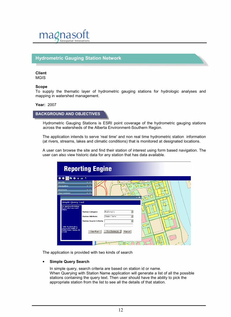
Hydrometric Gauging Station Network
Client
MGIS
Scope
To supply the thematic layer of hydrometric gauging stations for hydrologic analyses and mapping in watershed management. Year: 2007
BACKGROUND AND OBJECTIVES
Hydrometric Gauging Stations is ESRI point coverage of the hydrometric gauging stations across the watersheds of the Alberta Environment-Southern Region. The application intends to serve ‘real time' and non real time hydrometric station information (at rivers, streams, lakes and climatic conditions) that is monitored at designated locations. A user can browse the site and find their station of interest using form based navigation. The user can also view historic data for any station that has data available.
The application is provided with two kinds of search
• Simple Query Search
In simple query, search criteria are based on station id or name. When Querying with Station Name application will generate a list of all the possible stations containing the query text. Then user should have the ability to pick the appropriate station from the list to see all the details of that station.

13
• Generic Interactive Search
In Generic interactive query, user will be able to customize the query by picking the appropriate items from the criteria. Criteria’s are
o Category of Station o Station type o Measured parameters o Spatial Search Location o Search by Monitoring Agency Approximate Man Days of Work o Search by Drainage Area
The application is also provided with features as
� Export the report into a PDF, XLS, and word document. � Email the report.
METHODOLOGY
• System study
• System design
• Application software development
• Testing
• Deployment
TOOLS USED
• ASP 2.0
• . NET with C#
• ArcGIS Server 9.2
• Oracle, MS-Sql server, MS-Access
STAFFING
Project lead and 3 software engineers are working on this project at Bangalore office

14
ArcFM customization
Client
CenterPoint Energy Scope
Customizing ArcFM solution to seamlessly integrate it to our client’s asset management system by developing automated customized components. Year: 2003 BACKGROUND AND OBJECTIVES The client is one of the oldest natural gas delivery service companies in US. They are the nation's third largest combined electricity and natural gas delivery companies with approximately 5 million metered natural gas and electric customers. Arc Facilities Manager (ArcFM™) is a complete GIS utility solution for modeling, editing,
maintaining, and managing facility asset data in an enterprise system. ArcFM comes with complete data architecture for defining feature behaviour through one common, customizable methodology for the data model, data control, and interface. Magnasoft is working towards customizing ArcFM solution to seamlessly integrate it to our client’s asset management system. KEY ASPECTS OF THE PROJECT
• Implement and extend ArcFM objects for client’s application.
• Component based technology for developing custom objects and features.
• Developing Applications, which supports ArcFM Data Model and ArcFM Application framework.
• Store and manage spatial data using ArcSDE.
SERVICES RENDERED AND METHODOLOGY
1. ArcFM customization 2. Designer customization

15
1. Magnasoft Expertise in ArcFM Customization includes,
1. Understanding the Electrical & Gas Data Model for Distribution network and hence
identifying the needs of ArcFM Data management and automation tools. 2. Developing Applications, which supports ArcFM Data Model and ArcFM Application
Framework. 3. Developing ArcFM Auto updaters and Validation Rules based on the client's business
requirements. 4. Developing Connectivity & Non-Connectivity Validation Rules for Gas & Electric networks
based on the client's business process. 5. Developing custom ArcFM Context Menu functionalities for ArcFM Attribute Editor
selection set. 6. Developing custom ArcFM Auto Text Elements to be used within ArcFM Page Templates
and documents based on the client's business needs. Sample Custom ArcFM Applications
1. Electric Connectivity Tools These tools are used for connectivity between electric network features in an electric environment. The tools allow interactive or automatic connecting and disconnecting of two point features – transformers and fuses, to linear electric network features. 2. Reassign Repairs: This tool is used to detach the selected mains that need repair. This also provides a facility to re-attach the selected gas objects and attaching orphan repairs to any gas objects. Point feature repairs and the line feature (gas main and gas service line) relationships are maintained and verified for the repair correction, before re-assigning to the gas objects in the Gas Distribution Network.

16
3. Pipe in Polygon This tool is used for clipping and measuring of the length and diameter of the pipes against any select polygon. Pipe in Polygon involves the application with specific set of rules:
• Gas Mains should be clipped at the polygon edges
• Length and Diameter of the Gas Mains inside the polygon must be measured

17
Designer provides an integrated environment for preparing construction work sketches, work flow
management, structural and network analysis, automated layouts, and job cost estimates. It improves the ability of a utility to design and track distribution projects and maintains GIS data. Designer's open architecture and full integration support with Work Management or Enterprise Resource Planning systems allows for easy implementation to support the life cycle of a job. Designer also provides an automated means to update the baseline corporate GIS database, based on changes to the electrical, gas, and water distribution facilities shown in the work sketch. 2. Magnasoft’s Expertise in Designer Customization includes,
1. Understanding the Electrical & Gas Data Model for creating distribution Designs and
hence identifying the needs of Designer Data management and automation tools. 2. Developing Applications, which supports Designer Data Model and Designer Application
Framework. 3. Developing ArcFM Auto updaters and Validation Rules within Designer Framework based
on the client's business requirements. 4. Developing custom ArcFM Auto Text Elements within Designer Framework to be used
within Design Page Templates and Design Documents. 5. Customizing the Workflow Manager Processes to remove the unwanted steps based on
client's Business process. 6. Developing custom Design Process Tasks, Sub Tasks & Filters for customizing the
Workflow based on the client's Business process. Sample Custom Designer Applications
1. Designer Auto Text Elements These AutoText Elements are used with Gas Main, IC Services Designs. These AutoText elements retrieve dynamic Design Data and populate into the Design documents based on the values stored in the current working design.

18
2. Design Post This is a custom tool, which overrides the out-of-the-box M&M post tool. This is used to avoid conflicts while doing design revisions. Out-of-the-box M&M post tool creates workflow status conflicts while doing design revisions. Also the custom tool will automatically delete the design version after posting. 3. Custom Design Login
This tool is used to login to ArcFM & Designer at the same time. This avoids separate logins to ArcFM & Designer. The tool preserves the ArcFM login information to be used for Designer login if the same account has access to the Designer. METHODOLOGY
• System study
• System design
• Application software development
• Testing
• Deployment
TOOLS USED
• ArcGIS 8.3
• ArcObjects
• Microsoft VB 6.0
• ArcFM 8.3.1
• ArcSDE 8.3 (with Oracle)
• Existing Application Framework STAFFING
1 Project Lead and 2 Software Engineers are working on this project

19
Report Writer (Component)
Client
CentrePoint Energy Scope
Development of a report writer component that serves as a web based business intelligence with mapping features. Year: Since 2004
BACKGROUND AND OBJECTIVES
The client is one of the oldest Natural Gas delivery service companies in US. They are the nation's third largest combined electricity and natural gas delivery companies with approximately 5 million natural gas and electric customers. The key objective of this project was to develop a Report generation component, which serves as a Web-based business intelligence with mapping features. This component would provide simplified end-user reporting in a controlled, business-oriented environment. KEY ASPECTS OF THE PROJECT
• System study
• Develop a map-enabled web based application with query shell integrated with the existing system.
• Creation of a critical component to facilitate Ad hoc reporting.
• Exporting the reports in multiple formats i.e. PDF, XLS, and DOC.
• Database compatibility for Oracle, SQL Server, DB 2.
• Facilitating Map based query analysis.

20
PRODUCT DESCRIPTION
1. Product Perspective:
2. Product Features:
• Standard Reports – Commonly run reports that may optionally include parameters for content and format flexibility.
• Report Domains – Reporting environments appropriate to business users’ affiliations or interests set up and maintained by the administrator. Each domain contains all the data sources needed for the types of reports and graphs users will want to run or create.
• Personal reports – These are reports that are generated using query shell and a provision is given to save such reports as “My Reports”.
• E-Mail – Every user having access to reports can receive timely information via e-mails in printable format.
• User Groups and Security – Identifies individual users and the security associated with them; administrators can combine multiple users into groups to allow for group- level report association.
• Upload and download Reports – User can download and upload the reports in any formats.
• Export – Users can view the information in the format that best suits their needs and export to multiple format support – including, Excel, Doc and PDF
• MAP Navigation – User can zoom In, Zoom Out, Pan, and FullExtent etc in the report with map.
• Identify – User can click on any feature of map and view related information.
• Rendering the selected features.
• Zoom to the selected features.
• Query Analysis– Buffering and Spatial analysis.
Report Writer Component
Data Access Administration and Security
Enterprise Reports Query and Analysis GIS and Mapping
Data Source

21
2.1. User Classes and Characteristics
� Data Access
� Provides comprehensive, native access to Oracle, SQL Server and access data sources, optimized for reporting and GIS mapping.
� Administration and Security
� Securely manages and administers broad deployment of information to unlimited numbers of users. � It provides a complete environment for management and administration facilities, enabling organizations to build and deploy standard reports. � Provide ad hoc and online analytical processing capabilities to specified users. � Assign user groups, define access rights and ensure security. � Allow administrator to define alias name for table and related table fields.
� Enterprise Reports
� Supplies all advanced Web-based features; people need to use reports effectively, such as simple and ad-hoc reports. � Supported all output formats as PDF, EXCEL, and DOC. � User can customize report. � The user can save the results as a new report generated in a preferred format. � Reports can then be viewed, printed, or taken offline for even further analysis. � This component also facilitates the management and sharing of reports. � Users have the capability to access and analyze data in a way that is best suited to get exact results and then share and collaborate on that information in the most effective way possible.
� Query and Analysis
� Combines all the functionality of query tools and reporting tools into a single powerful solution with one common interface. � Allowing users to generate ad hoc queries, in-depth analysis in the most collaborative and efficient manner. � End-to-end reporting solution that makes even a single piece of information.
Export

22
� Enhanced GIS analysis Report
� Provides a more intuitive way for processing and comprehending certain information, enhancing your ability to analyze and discern critical trends and patterns.
� Users can aggregate real-time information from different databases, build individual ad hoc queries and formatted reports, and then instantly transform their results onto geographic maps.

23
2.2. Operating Environment
Products ASP. Net with VB .net, ArcIMS 4.0
Platform PC-Intel
Operating System Windows 2000 – Server and Windows XP
Service Packs/Patches SP 2 or SP 3
Web Server Internet Information Server
Web Server Version Five (5)
Report Tool Crystal report
Crystal Report Version Nine (9)
Data Base Oracle, MS-Sql Server, Access
Supported Web Browsers Internet Explorer 5.0 and above
METHODOLOGY
• System study
• System design
• Application software development
• Testing
• Deployment TOOLS USED
• ASP 2.0
• . NET with VB.net
• ArcIMS 4.0
• Oracle, MS-Sql server, MS-Access STAFFING
1 Project Lead and 3 Software Engineers are working on this project at Bangalore office

24
Field Survey Data Uploading Tool
Client
Under NDA Scope
Integration of Survey Data with GIS system and customization. Year: Since 2004 BACKGROUND AND OBJECTIVES
The client is a leading provider of enterprise infrastructure software solutions to support the management, replication and distribution of geographic data within and between organizations. These solutions contribute in improving the Geospatial data, improve customer service, and increase the productivity and efficiency of GIS. Our client’s operations are spread across 5 continents and include government bodies, utility companies, mapping agencies among others.
The key deliverables of this project were integrating survey data into GIS format database after segregating feature classes under different datasets and development of toolbar with functionality for creating new menu, submenus and commands. KEY ASPECTS OF THE PROJECT
• Functional specification documentation
• High level Design documentation
• Implementation
• Unit testing
• Test specification documentation
• System testing and bug fixing. SERVICES RENDERED AND METHODOLOGY SERVICES RENDERED
1. Transfer of survey data to GIS format and segregate feature classes under different datasets. (Geodatabase format)
2. Development of New Editor Toolbar for creating new menu, submenus and commands with following functionalities.
• Survey related functionality (Includes services works like bilateration, trilateration, chain and offsets.)
• Editing related functionality
• Management related functionality
• Topology related functionalities

25
• Validation related functionalities
• Display related functionalities METHODOLOGY 1. Snapping
Snapping Configuration Dialog- a dockable Window designed& developed containing data pertaining to the Snap Profile Item, namely Option Profile Item & layer Profile Item. ArcObjects Interfaces pertaining to Snapping used for development. The following Classes were created for the Snapping to be performed on the Various Survey & Editor Tools
• Snap Profile The snap profile is a specification for snapping that can be loaded into the snap environment. The concept of a snap profile is designed to enable simple restoration of snapping properties when custom snapping settings are loaded and unloaded by tools. Snap profile can be defined by:
i. An ordered list of snapping options (e.g. intersection, vertex, line, survey point),
ii. An ordered list of feature layers
• Snap Manager: The SnapManager class is responsible for loading a SnapProfile into the Editor’s snapping environment. The SnapManager class will isolate the rest of the system from both the snapping configuration window, and making changes to the Editor’s snapping environment The SnapManager broadcasts an event that the snap environment has been changed

26
2. Selection
A module was developed in the similar lines of existing Selection in ArcGIS along with a set of Additional Functionalities. Menu were added in the created Editor Tool bar. Tools were developed. Feature selection and generating the statistics based on the tools.
o Select By Attributes
o High Light By Date
o Clear Selection
o Select By Sketch
o Edit Tool
Selection Core Class created and developed for taking care of all the activities with respect to Selection of features for editing and other purposes
3. Attribute Editing
o Target Layer DropDown Designed &developed and placed in the created Editor Toolbar. The layers are filtered based on various conditions and parameters and stored in the Target Layer DropDown. This is essential as when the users who have editing permissions, can perform editing on the various feature classes and choose the Target Layer from the dropdown. o Edit Events Controller: Class was created to monitor and maintain all the editor events taking place with the Phoenix System- what actions takes place on Open Document, New Document Events, Item Added, Deleted Events etc.

27
o Attribute Updates: Responsible for updating attributes according to OS rules when a feature is created, edited or deleted. When features are split or merged Attribute Update transfers some attributes from one feature to another. Attribute Update may also handle more specialized attribution functionality such as transferring names and text between features. TOOLS USED
• .Net C#
• ArcGIS
• Arc Objects
• ArcSDE
• Oracle 9
• Rational Rose/Visio
STAFFING
4 Software Engineers are working on this project at client’s office in UK

28
Migration of MapObjects/Avenue based Application to ArcGIS
Client
Criterion Engineers Inc Scope
Migration of VB/Map Objects and Avenue based application to Arc GIS environment. Year: 2003 BACKGROUND AND OBJECTIVES
The client company is a recognized leader in urban planning domain with expertise ranging from land use and transportation planning to waste water recycling. Criterion’s flagship product for planning support – INDEX, helps stake holders/decision makers to create and implement plans and further provides indicators to achieve and update set goals.
The first version of INDEX was developed on Avenue and VB/Map Objects. The main objective of the project was to migrate INDEX to Arc GIS as the existing environment lacked scalability and flexibility. ArcObjects, the script used for Arc GIS is built using Microsoft’s Component Object Model (COM) technology. Hence, a well-documented COM based system using Visual Basic and Arc Objects object model was developed. This offers even more possibilities of customization for
users.
The migration was done mainly because most of Criterion’s existing and potential future clients had already adopted the Arc GIS system.
KEY ASPECTS OF THE PROJECT
• Developing VB executable A VB executable containing a class (classes) that calculates transit proximity using the source data objects was developed.
• Operations Research based project in transportation domain using statistical tools
• Migration of Map Objects/Avenue based product to ArcGIS environment using COM technology

29
SERVICES RENDERED AND METHODOLOGY
Some of the Indicator tools that were migrated to the ArcGIS environment include:
• Amenities Adjacency This tool calculates the percentage of residents in the study area within walk able distance of amenities. This is determined by first creating buffers (walk able distance – user specified) around each amenity and calculating the total number of residents falling within this buffer and comparing with the total population in the study area.
• Amenities Proximity This tool performs three statistical operations on the total study area, which is
classified into different land use patterns. The first operation involves calculating the shortest network distance from each of the dwelling units (origins) to the nearest amenity. This value is populated into the Geodatabase.
The next operation involves determining for each landuse a ratio between the sum of the product of the network shortest distance of each dwelling unit and the population for that dwelling unit (available as attribute information) and the sum of the total population of all the dwelling units. In the final operation, the second operation is performed over the entire study area instead of each landuse.
• Bus Transit Adjacency to Housing This tool calculates the percentage of residents in the study area within walk able distance of bus transit stops. This is determined by first creating buffers (walk able distance – user specified) around each bus transit stops and calculating the total number of residents falling within this buffer and comparing with the total population in the study area.
• Bus Transit Proximity to Housing This tool performs three statistical operations on the total study area, which is classified into different land use patterns. The first operation involves calculating the shortest network distance from each of the dwelling units (origins) to the nearest bus transit stop. This value is populated into the Geo-database.
The next operation involves determining for each landuse a ratio between the sum of the product of the network shortest distance of each dwelling unit and the population for that dwelling unit (available as attribute information) and the sum of the total population of all the dwelling units. In the final operation, the second operation is performed over the entire study area instead of each land use.
• Bus Transit Adjacency to Employment Calculates the percentage of employees in the study area within walk able distance of bus transit stops.
• Bus Transit Proximity to Employment The first operation performed by this tool calculates the shortest network path from business point to bus transit stop.

30
The next operation involves determining for each landuse a ratio between the sum of the product of the network shortest distance of each business point and the number of employees for that business point (available as attribute information) and the sum total of all the employees of all the business points.
• Park Adjacency Calculates the percent of residents within user-defined linear distance of parks or school yards
• Park Proximity The first operation performed by this tool calculates the shortest network path from dwelling units to parks or schoolyard. The next operation involves determining for each landuse a ratio between the sum of the product of the network shortest distance of each dwelling unit and the number of residents for that dwelling unit (available as attribute information) and the sum total of all the residents of all the dwelling units.
• Internal Street Connectivity Calculates the ratio of the intersections to sum of intersections and cul – de – sacs
• Street Route Directness This tool performs an operation to calculate the average ratio of shortest drive able route distance versus straight-line distance, from residents and employees of developed parcels to central node destination.
• Pedestrian Intersection Safety Calculates the percent of intersections equipped with traffic control devices
• Pedestrian Accessibilities Percent of user-defined destinations within 15-minute walk time from user- designated origin point, weighted by pedestrian trip generation and attraction capacity of origins and destinations TOOLS USED
• Arc GIS 8.2
• Visual Basic
• MS Access
STAFFING
4 personnel and 1 Project Lead was involved in this project

31
Property Management Information System
Client
Karnataka Housing Board (KHB) Scope
Development of Management Information System for KHB enabling viewing of project specific information on maps using a GIS mapping tool Year: 2002
BACKGROUND AND OBJECTIVES
Karnataka Housing Board (KHB) is a statutory State Government of Karnataka undertaking, established in 1962. KHB has its presence in the State through a wide network of Project Offices. It has developed and implemented many prestigious housing projects throughout the State, providing housing accommodations to many. The objective of the project was to develop a Management Information System for KHB, which caters to the various needs of the Site Users. The KHB MIS provides a solution that has facility to view Project specific information on maps using GIS mapping tools. The Property related data is maintained by KHB, whereas the Applicant data is maintained by CCSL (Canbank Computer Services Ltd., IT solutions and banking services providers for housing projects undertaken by KHB). Synchronization between both the databases takes place to reflect changes made in Property and Applicant data. KEY ASPECTS OF THE PROJECT
• The system provides the facility to view property related information on maps
• The entire property related part for each project handled by KHB is maintained by the new system
• The system communicates with CCSL database to get applicant related information which is updated by CCSL application for property status and registration number.
• The system with a new user interface provides a new look and feel
• Provides the facility to manage users and user groups
• Provides the facility to view deviations in the plans in textual format and on the map
• The system provides the facility to generate reports

32
SERVICES RENDERED AND METHODOLOGY
• Digitisation
• Phase I - Web Application Development Functionalities o Viewing of project information on maps –
state map, district map, location/key plan, layout/site plan, floor plan
o Basic map functionalities – pan, zoom, display etc.
o Application status o Account information o Property status updation
• Upgrade existing KHB web site
• Phase II - Web Application Development (for KHB administration and operator) o User management o Uploading o Deviation information o Reporting o Auction information
TOOLS USED
• AutoCAD Map 2000
• Autodesk MapGuide Server 6.0
• MS SQL Server 2000
• PHP 4.0
• Internet Information Server 5.0
STAFFING
One Project manager, and a Sr. CAD engineer for the project duration

33
Real Estate Information System
Client
A.M.B.S Real Estate Co. Scope
To develop a property and real estate information management system interface for property purchasers and sellers to bring about effective transactions. Year: 2001
BACKGROUND AND OBJECTIVES
AMBS is a leading property and real estate company situated in Riyadh.
The objective of the project was to develop a spatially enabled decision support system for property and real estate management.
KEY ASPECTS OF THE PROJECT
• Creation of base map:
o The creation of base map showing street level data for Riyadh using satellite imagery and ground truthing
• Development of a map-enabled Decision Support System for real estate business
o Dynamic map display of properties satisfying customer defined criteria o Enables buyers to select properties available for purchase, dynamically on the
map and allows processing of the same for report generation and sale-deals o Enables buffering whereby queries can be made to select properties available for
sale located at a certain distance from the reference site o Overlay of buffering results on database query output and vice-versa
• As part of future enhancements, the entire application developed will be ported to the Web using ArcIMS because of the scalable architecture and ease of creating map services. This web-enabled application helps the customer narrow down on properties, which suit his requirements. The system would facilitate online payments and online negotiations between customers and clients.

34
SERVICES RENDERED AND METHODOLOGY
• Mapping o Digital map creation of Riyadh city consisting of administrative divisions (such as
districts, blocks, divisions, etc.), and parcel information along with major land marks and other spatial features which influence the real estate market
o Orthorectification of satellite imagery and georeferencing using image processing technology for base map creation
o Normalisation of AutoCAD drawings and conversion to DXF format o Creation of ArcInfo coverages through transformation of DXF by topology
cleaning and building of coverages o Export of coverages as shapefile and georeferencing to city road network o Shapefile data included parcels/ properties, district & city boundaries, landmarks,
roads
• Data-base design and development o The performance of Maps & SQL server database is dynamic, allowing the user
to perform both spatial and non-spatial queries. o Involves system design and database design (integration of map & SQL
database) o Llinking of Map & SQL database; queries [except buffering] made on SQL
database on the server side and results displayed on the map
• Application Development - Functions o Uploading of new maps. o Querying [spatial/buffering & attribute/on database] o Printing of map o Loading of maps o Purchase of property o Integration of map & SQL database o Zoom In/Out and Pan.

35
TOOLS USED
• Mapping - Arc Info 8.2, Arc View, and AutoCAD Map
• Application - VB 6.0 [Map Objects + Vflex](Language & OCX controls)
• SQL Server 2000 (Database), Crystal reports
STAFFING
5 personnel were on this project full time comprising of Project manager, developer, database specialist and CAD engineers.

36
Overlay Analysis System
Client
Under NDA Scope
Development of tax calculation tool Year: 2001
BACKGROUND AND OBJECTIVES
Company is a large US based Parcel Conversion Company.
The main objective of the application is to help US Government in calculating the tax on land used by US citizens. The application involves calculation of area of land use resulting from
overlay process of polygon layers done by the operator over a section.
KEY ASPECT OFTHE PROJECT
• Perform point/ polygon overlay of layers over sections or areas by selecting the layers.
• Perform the shading of the overlaid layers based on Linear Debasement or Soil Type or Land Use Type.

37
• Provide user with acreage of linear debasement area with respect to land use, soil type, and parcels for Tax calculation.
SERVICES RENDERED AND METHODOLOGY
• System Analysis o Collect requirements of the client o Analyse the requirements o Design the Application
• Data-base Design o Area Information o Section Information o File List Information o Land Use Information
• Application Development
• Testing and Quality Control
TOOLS USED
• Visual Basic 6.0
• ArcObjects 8.1
• Microsoft Access 2000
STAFFING
1 Project Lead and 4 Engineers were involved in this project.

38
Gas Distribution Network System
Client
Northern Indiana Gas Public Co. (NIPSCO) Subcontract from Computerised Facilities Inc., USA. Scope
Data capture and conversion of existing gas distribution facility information stored in paper maps and records to digital format and development of a GIS-based gas distribution network system for effective management Year: 1997-1998
BACKGROUND AND OBJECTIVES
Magnasoft, as a subcontract from CFI, developed a gas distribution network system for the end-customer, NIPSCO. NIPSCO is one of the largest public service companies in the State of
Indiana responsible for gas distribution.
KEY ASPECTS OF THE PROJECT
• Graphical legacy data conversion of gas network
• Automated tool development

39
SERVICES RENDERED AND METHODOLOGY
• Production planning and source data compilation o Production schedules were defined and the placement rules and guidelines for data
capture and conversion were complied as per specific requirements o Source documents included paper maps, reports and guidelines for feature
placement and annotation/dimensioning requirements
• Data conversion o Generation of geographically referenced grids using lat-long from hard copy maps o Conforming source data with grid by warping and rubber-sheeting o Conversion of graphical legacy data to digital format. This included the gas pipelines,
pipe accessories such as valves, regulators and Corrosion Control Stations o Features were placed in relation to land base and other gas features as per
NIPSCO’s requirements and all network relationships were maintained
• Attribution o Design of gas network database and attribution of network elements with pipe
attribute data such as size, location, pressure, installation details, suppliers, durability, life period, consumers etc.
• Development of conversion tools o Development of conversion tools was
a major component whereby the conversion process was automated. This included graphical data generation, pipe accessories and other fabricated parts with the help of spcially designed tools
o Maps produced were used to analyse the pipe layout design problems, modification called for in the process, fuel distribution etc
• Network Connectivity o Classifications for data retrieval – size
of pipe, material, pressure, location and corrosion control station
o Classification for data analysis – pipes in the vicinity of fire hazardous areas, network connected to specified corrosion control station
o Location of other suppliers

40
TOOLS USED
• AutoCAD Map
STAFFING
There were around 40 resources on this project for full time comprising of Project manager, CAD engineers, developers and database specialists.