machadodorp to nelspruit via...
TRANSCRIPT

81
Machadodorp to Nelspruit via Schoemanskloof60 kilometres4
Machadodorp
Waterval Boven Ngodwana
Lydenburgturn-offR36
Montrose Nelspruit
BarbertonR40
White RiverR40
60 km 90 km15 km0 km
Schoemanskloof
Waterval-Onder

4 Machadodorp to Nelspruit via Schoemanskloof 60 kilometres
82
The BaKoni, by tradition, were agriculturalists who were taken unawares by the upheaval that struck southern Africa in the early 19th century. Displaced from Dalmanutha and other settlements, they attempted to hold out here at Blouboskraal, their stone struc-tures affording some measure of fortification. They also supposedly collected rocks, which they rolled down on to their attackers.
Helvetia (the names means ‘Switzerland’) was a tiny settlement in the 19th century that persisted into the first half of the 20th century, with a small school here. Helvetia had a post office and, in the 1880s, was a staging post for coaches travelling between Bergendal and Lydenburg.
In December 1900 a sharp battle occurred at Helvetia when a force of almost 600 Boers under General Ben Viljoen attacked a number of British forts here. The British set up forts every ten miles (sixteen kilometres) along the road to Lydenburg, that at Helvetia being the closest to Machadodorp. In addition to a garrison of 250 men, the English had a base, under the command of Major SL Cotton, nearby with 270 men.
The British manned a series of low koppies, most just east of the N4 (they’re today obscured by the plantations that Sappi began planting in 1964). Their fortifications, however, were badly prepared and, in the middle of the festive season, the officers and men were in no mood for military preparations. In fact, as it later emerged, many of them were in no fit state at all for fighting, one observer noting that the British had ‘more rum than ammunition’.
Climbing the hill just after the Schoemanskloof split, west of the road is a dirt turnoff to the Sappi plantation at Camelot North. This is one of the most easily accessible examples of Mpuma-langa’s quite astonishing archaeological heritage; the thousands of intricate stone structures that cover much of the province.
According to Delius and Hay in Mpumalanga, an illustrated history, ‘some of these settlements were very extensive, and stretched for several kilometres; they really amounted to large towns built out of stone. Their walls were so strong and well built that many of them still stand today, intact and overgrown and hid-den from the eyes of all but the most attentive passing motorists.
‘The communities that built these settlements varied in size, but were larger than many would believe possible for that time. In the 18th century, archaeologists estimate that as many as 40 000 people lived on the escarpment between latter-day Machadodorp and Lydenburg. People moved in and out of the area, interacted and exchanged elements of culture.’
Delius and Hay write that the stone settlements typically consisted of ‘three inter-related elements: homesteads, compris-ing an inner core of cattle kraals or enclosures, surrounded by enclosures for human habitation; paths or roadways edged in stone, designed to channel the movement of cattle to and from their daily pastures, and stone terraces, aimed at creating level areas for cultivation.’ Mpumalanga’s stone ruins, according to Professor Delius, are an ‘underappreciated, under-recognised and under-researched’ resource.
2 E 75 W
10 E 50 W

83
After Viljoen’s men attacked in dense mist at 3.30 on the morn-ing of December 29, the British were quickly overwhelmed, sixty of them dead or wounded and 230 captured, some of the British officers being woken up so that they could be taken prisoner.
The Boers suffered five dead and seven wounded but had achieved a stunning victory. (The South African War was a remark-ably cosmoplitan conflict; among the wounded on the Boer side at Helvetia was an American named Wild (shot in the neck) and an unnamed Philippino (shot in the knee).
The newly-appointed British commander-in-chief, Lord Kitchener, was furious, especially over the loss of a 4.7-inch naval gun named the Lady Roberts, after the wife of his predecessor as supreme commander.
With their prisoners and their booty, the Boers moved off towards Dullstroom. But before getting there they were forced to let many of the British go because they were simply too drunk to walk. Writing disapprovingly of their conduct afterwards, Viljoen said: ‘The Tommy is such a helpless individual when he has nobody to give him orders.’
The irate Kitchener made a scapegoat of Major Cotton, having him courtmartialled despite evidence that he had recently suffered malaria, and was concussed during the battle, having been wounded in the head and stomach.
Eventually, after lobbying by some powerful friends, Cotton’s reputation was partially, but never completely, restored.
Author Bridget Hilton-Barber wrote of this section of road: ‘One of my all-time favourite [roads] is down the Schoemanskloof Pass from the N4 to Nelspruit. At the first glimpse of the Bambi Motel (a symbol to my generation of nights of passion, wasted youth and heady adventure), my heart skips a beat and my pulse races. The grasslands and pine forests start giving way to valley and bush; the air changes from crisp to sultry. The Crocodile River cuts its way through mountain and farmlands, plunges over the Montrose Falls and joins the Elands River, its principal tributary. And the road unwinds from a tight corkscrew into an undulating pass, from a gentle riverside meander into a double-lane highway, and the broad fertile Crocodile River valley opens like a movie. . .
The Bambi Motel c. 1970

4 Machadodorp to Nelspruit via Schoemanskloof 60 kilometres
84
The heads have been dated to about 500AD. Similar pottery has since been discovered in KwaZulu-Natal. This, historians believe, shows that these early people were moving around present-day South Africa without confining themselves to one small region.
The pieced-together heads are on display in Cape Town but exact replicas can be seen at the Lydenburg Museum.
Bambi’s current owner says the lodge, which opened in the late 1950s or early 1960s, takes its name from the European roe deer that were, at some stage, introduced on what used to be a 6 000 hectare farm (when Disney released the famous film version of Bambi in 1942 they changed the title character’s species from roe deer to the North American whitetail deer.)
Some of the deer still exist at Bambi. The farm on which the motel was built used to belong to farmer Japie de Beer, after whom De Beersnek is named.
Here is the turnoff to Lydenburg. Lydenburg was a particularly important town in the early days of the ZAR and the area has a rich and diverse history. One of the most fascinating parts of that history is represented by the mysterious Lydenburg Heads.
In the 1950s, young Ludwig von Bezing came across strange pot-tery fragments while playing on his father’s farm near Lydenburg. As a teenager, Von Bezing excavated the fragments but it was only later, when he went to the University of Cape Town to study medi-cine, that he realised the significance of his find. Von Bezing gave the fragments to the university’s archaeology department, where they were pieced together, studied and carbon-dated.
According to the Lydenburg Museum, ‘two of the clay masks are large enough to probably fit over the head of a child, the other five are approximately half that size. The masks have both human and animal features, a characteristic that may explain that they had symbolic use during initiation and other religious ceremonies.’
15 E 61 W
Exact replicas of the Lydenburg Heads

85
Former Machadodorp resident Hannes Bezuidenhout, who was born in 1930, remembers how, in the 1940s, only big, mostly American cars such as Chevrolets, Dodges, Buicks and Packards used the dirt road through Schoemanskloof. Until the 1970s, when the Waterval Boven tunnel was built, this was the only practical route to Nelspruit. In those days, he recalls, the speed limit was just 50 km/h.
In 1848 Watervalshoek (now Sondagskraal), was allotted to Johan Schoeman. In the same year the farm Somerset was given to JJH Viljoen. The kloof is a narrow valley barely 1.5 km across at its widest. In this valley there were soon so many Schoemans (and the family so attached to a few first names) that almost all the men were given nicknames to differentiate them, for instance, Deaf Fanie and Fanie Colony (the latter coming from the Cape). Descendants of the original Schoemans continue to live in the kloof.
From the mid-19th century Schoemanskloof was usually, informally, divided into two. The part above Patatanek was known as ‘Bo-Schoemanskloof (Upper Schoemanskloof ) and that below as Schoemanksloof Onder.
The long trek up to Patatasnek was known as ‘Langasem’ (‘deep breath’) because of the time and effort it took to get to the top. The name Patatasnek dates from the days when there used to be an outspan area (where oxen would be unyoked and allowed to graze while the wagon riders rested) and where it was the custom to roast sweet potatoes on the camp fire. Just as you crest
Patatanek it is still possible to make out on the side of the hill (on your right) a copse of trees, which marks the spring where wagon riders would draw water more than a century ago.
Schoemanskloof used to be well known for its sweet potatoes. Decades ago locals used to bake sweet potatoes in the oven, then grate them and add sugar and hot water to make a drink that they called ‘Fango Coco’ although no-one now recalls where the name came from.
The first proper road through Schoemanskloof was built in the 1920s under the auspices of a Hollander, Joe Barbas. Most of that road was superseded by a new alignment begun in the 1940s – essentially today’s road. For decades, long-time residents of Schoemanskloof chuckled about an incident that occurred when the road was being tarred in the late 1940s. The driver of the tarring truck forgot to switch off the gas heaters that kept the tar liquid. As the tar was being sprayed onto the road it burst into flames. Unable to put out the fire, the driver kept driving and his truck kept tarring – until all the tar had been sprayed on to the surface. The result was that 3km of road, at Mooiplaas, was on fire, a thick cloud of black smoke hovering over the area.
Joe Barbas, or at least a likeness of him, is still to be seen here on the side of the road. Born in Hilversum in the Netherlands in 1883, Barbas came to South Africa at the age of nineteen. Local
31 E 28 W

4 Machadodorp to Nelspruit via Schoemanskloof 60 kilometres
86
farmer, educationalist and part-time historian Dr Faan Coetzee has counted the following occupations pursued by this energetic man: bookkeeper, teacher, farmer, army paymaster, road builder, insurance agent, shopkeeper, butcher and tax collector.
Whatever he did, it appears that Barbas was a likeable man. When, in 1927, the men working for him discovered a rock near Patatasnek that they reckoned looked like him, they hauled it up to the road, painted it white and labelled it ‘Joe’.
The pot-bellied rock soon became an institution with motorists who stopped to have their photos taken with Joe, especially after a group of schoolboys from Hilton College in KwaZulu-Natal started a tradition of occasionally painting Joe (they chose their college colours). When the new road was built in 1947/48 Joe was moved to a new alignment. In 1971, Joe was moved some 10m to make way for the widening of the road and, finally, in 2001, when the road was upgraded again, Joe was moved to his present location, about 500m from the previous spot, to make it easier for motorists to stop. The real Joe died in 1974.
On the side of the hills north of the road you can perhaps spot what appear to be some rockfalls. Dr Faan Coetzee explains that this isn’t actually a natural rockslide but was the result of actions by the South African Army during the Second World War. He recalls that, during the war, the local Home Guard was reinforcing the border with Mozambique, in the event of an Axis invasion through that country. (Madagascar was in the hands of
36 E 23 W

87
the Vichy French and German submarines and even Japanese warships were active in the southern Indian Ocean.) Residents of Schoemanskloof became used to the sight of seemingly endless convoys of men and arms being driven to what it was believed might become a new front.
So it came to pass that the military decided one day to give the people of Schoemanskloof a demonstration of what firepower the Union Defence Force possessed. The target for the military’s display of firepower was the side of the krantz. Dr Coetzee recalled many years later.:‘The thunderclaps against the krantz and the falling rocks were breathtaking, even terrifying. As a young boy of almost seven, the scene had a profound effect on me. It made such an impression that even today I can still see it in my mind’s eye. If anyone is brave enough to go look at the side of the mountain where the rocks crashed down, I am sure they will find shrapnel.’
The Junglespruit is home to a special fish called Kneria auriculata or Southern kneria. In South Africa this little fish (adults grow up to about 5cm in length) occurs only in streams feeding the Crocodile River. The only other places you will find kneria are streams feeding the Zambezi and its tributaries; at some stage, thousands or hundreds of thousands of years ago, the population in Mpumalanga became cut off from those further north and this very fact of its isolation means that the Southern kneria is an extremely endangered fish.
The kneria avoid big rivers such as the Crocodile because of

4 Machadodorp to Nelspruit via Schoemanskloof 60 kilometres
88
Schoemanskloofers would line up to watch the rally drivers roar past.
A decade after the first rally, in 1962 Total doubled the prize money and included the incentive of an all-expenses-paid entry to the Monte Carlo Rally. At the time the ‘International’ was reckoned to be the biggest rally sponsorship in the world. In 1968, Prince Rainier of Monaco entered a team in the rally, and from 1969 until the last running of the International in 1977, there were always at least fifteen to twenty overseas drivers and co-drivers taking part.
Old Joe’s Kaia has been a popular stopover on the Schoemans-kloof road since the 1950s, when Johannes Boers bought a patch of land here, primarily so that he and his wife could get some respite from the winter cold of Belfast where they lived. In 1954, because so many travellers stopped, asking for accommodation, the Boers built the first of two rondavels on their property.
Boers’ wife was known as ‘Joe’ or ‘Jo’. She managed the establish-ment until 1960 when she and her husband moved back to Belfast. Old Joe’s Kaia got its name in 1984 when the owners named it after the Old Joe rock (‘kaia’ means ‘home’). Today Old Joe’s Kaia – which has one of the best kitchens in these parts – is co-owned by Marian Cottle, a granddaughter of the Boers. Old Joe’s takes its name from the roadbuilder, not from the previous owner.
If you’re travelling this way in spring the scene is one of bright
the predators lurking there and so restrict themselves to small streams like the Jungle and Sterk spruits, which are no more than 1km to 2km in length.
According to environmental consultant Etienne van der Lith, when, in the late 1990s, a bridge over the Junglespruit was being planned it was realised that the supporting structures would inhibit the fishes’ ability to swim upstream to near the spruits’ sources, where they breed.
Engineers built special fish ladders to enable the kneria to pass unhindered. However, because of their diminutive size the fish have a limited ability to accelerate upwards, against the flow of the water, so special blocks were cast on top of the concrete under the bridges, essentially little resting places where the kneria could regain their strength before making their next sprint.
(According to a report by the Department of Water Affairs and Forestry, published in 2002, ‘These fish have been reported to breathe air and to climb over damp rocks and up the sides of wa-terfalls during migrations.’) Studies undertaken after the fish ladders were installed confirm that the kneria have succeeded in crossing the area of the bridge and reaching their spawning grounds.
In the 1950s and 1960s the biggest event on the South African racing calendar was the Total Pretoria-to-Lourenco Marques International Rally.
Begun in 1952 by the Pretoria Motor Club, the event drew a hundred or more teams each year. In the middle of the night,
40 E 22 W
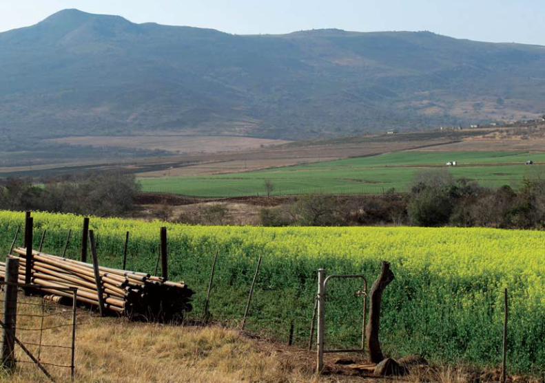
Yellow canola contrast against fields of young wheat in early Spring. In the background rises Spy Hill
89
4 Machadodorp to Nelspruit via Schoemanskloof 60 kilometres
90
into northern Namibia and southern Angola. Kiaat is a popular tree for many reasons; in spring it has clusters of bright yellow flowers that give way to round, flat seed pods. The red sapwood is also easily worked into particularly attractive furniture, which is resistant to wood borers and termites, and the bark and leaves are used in a variety of traditional medicines. Although Schoemansk-loof has an unusually high concentration of kiaat it was decided to relocate the trees that would be uprooted here.
(At more or less the same time, widening of the Elands Valley section of the N4 necessitated uprooting a long section of indig-enous flora. This included a number of protected aloe species whose disposal attracted collectors from as far away as Namibia.
green young wheatfields set strikingly against the yellow flowers of canola plants, grown for the oils that are made out of their seeds. The hill that dominates in front of you as you drive east is Spionkop (‘Spy Hill’). During the South African War, first the Boers and then the British maintained an observation post on its summit because, from there, anyone moving through the kloof could be observed.
At La’bri Estates, road widening in 1999 threatened a small forest of kiaat (Pterocarpus angolensis). These slow-growing trees, which reach a height of about 15m or more, are found in a band that stretches through Mpumalanga and Limpopo to central Mozambique, northern Zimbabwe, across the Caprivi Strip and
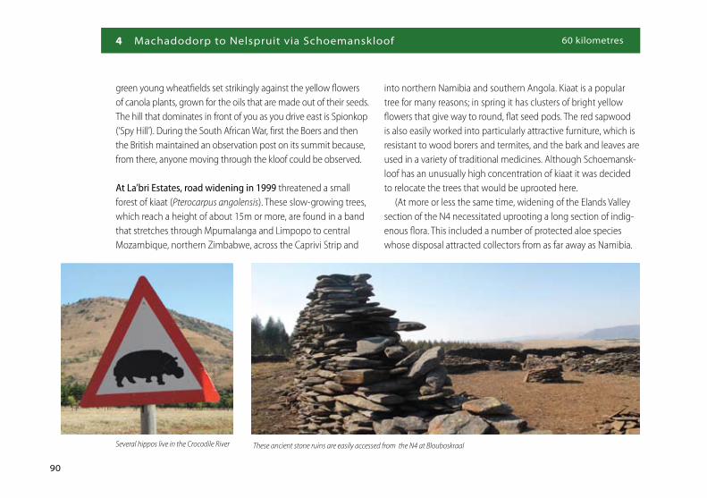
These ancient stone ruins are easily accessed from the N4 at BlouboskraalSeveral hippos live in the Crocodile River

91
First, however, local sangomas were invited to collect whatever affected medicinal plants they wanted.
The river here is, as the sign says, Devil’s Creek, believed to be so named because it gave ox-wagon drivers a devil of a time to get across. In fact, the current sign is misplaced. The real Devil’s Creek is some distance to the east.
The signs warning you of hippos in the vicinity are not merely pandering to tourist fancy. The river just north of the road had, in 2009, a resident population of some eight or nine hippos, which could regularly be seen by turning off the road signposted St Paul’s Chalets.
Joubert and Sons is one of the larger citrus farming enterprises in Mpumalanga. The farm has 350 000 trees on 2 500ha and can deliver a million cartons of citrus a year.
According to Kobus Joubert, when his father started the busi-ness almost half a century ago, Schoemanskloof was mostly given over to the growing of naartjies (tangerines). Then, in the early 1960s a root disease virtually wiped out naartjie production in these parts and farmers began to diversify.
In 2008 the area was again in the media after a freak hailstorm, with hailstones as big as golf balls battering Schoemanskloof. One newspaper quoted Joubert as wondering whether the storm, which blanketed parts of the valley and killed cattle, sheep and other animals, had been caused by climate change.
Farmers in the area were not insured against hail damage for the simple reason that in the Lowveld hail was almost unheard of. At that time of year orange trees were either still budding or young oranges had just started forming; some 200 000 of Joubert and Sons’ trees were stripped during the 15-minute hailstorm.
Just here, on the northern side of the road, you should spot the remains of a small bridge. This bridge was built, from about 1915, for a narrow-gauge (24-inch) railway, one of only a few forestry railways that have existed in South Africa. The railway was built by Messrs Mark Wilson Ltd Colonial Timber Merchants of Johannes-burg to transport indigenous timber from a sawmill at Koedoes-hoek in the Schoemanskloof to the Elandshoek station on the Pretoria-Komatipoort main line.
The railway was 25km long and crossed the Elands and Crocodile rivers five times. The trains were hauled by a seven- and a five-ton engine between the sawmill and Elandshoek.
By 1920, the indigenous trees, including many towering yellowwoods, had been worked out and so the railway was put up for sale. The line and rolling stock – but not the engines – were bought by the company, Transvaal Citrus Farms, which started exporting citrus in 1923. Because there were no locomotives the company used gangs of labourers to push the wagons the 17km from the packhouse (still visible) to Elandshoek station!
In 1925, South African Railways took over the line, instituting a twice-weekly freight and passenger service (with locomotives)
55 E 8 W
50 E 12 W

4 Machadodorp to Nelspruit via Schoemanskloof 60 kilometres
92
that highway was divided into sections nine to sixteen.)
The establishment on your left just as you approach the junction with the N4 via Waterval Boven looks like a typical Lowveld game lodge. In fact, in 2009 it was the headquarters of funeral entrepreneur Martin Piek. This former furniture salesman started his funeral business in the mining town of Randfontein on the West Rand in 1989. Two decades later Martin’s Funeral Services had 165 franchises countrywide, burying some 20 000 people a year and generating turnover of over R200-million. The business’s main offices remained in Randfontein and Pretoria but Piek chose to base himself here because, as he explained simply, ‘it’s paradise’.
which stopped at five places along its then 20 km length. Finally, shortly after 1930, the line was abandoned.
The N4 between Hans Strijdom Drive in Pretoria and Komati-poort is divided into eight sections. You will have noticed the small blue route marker boards located alongside the road every 200m. These route marker boards help maintenance engineers with their planning and, should a motorist need roadside assist-ance, they are extremely useful in helping those coming to their aid to know exactly where the affected motorist is. Because, at this stage, there are ‘two’ N4s, the road through Schoemans-kloof is designated ‘Y’ and that through Elandskloof is ‘X’. (When the new highway east of Pretoria to the Botswana border was built,
Just below the point where the two sections of the N4 meet are the Montrose Falls, at the confluence of the Elands and Crocodile rivers, completely hidden from the motorway