macedon ranges landscape assessment landscape values · assessment of landscape significance so...
TRANSCRIPT
Macedon Ranges Landscape Assessment
Landscape Values & Significance
Fin
al R
ep
ort fo
r Co
un
cil A
do
ptio
n: M
arc
h 20
19
PE.2 ATTACHMENT 2

Macedon Ranges Landscape Values & Significance 2
Acknowledgements
The Macedon Ranges Shire has an anc i ent and proud
Abor ig ina l h i s tory . Complex ownersh ip and land s t ewardship
sys t ems s t r e t ch back many thousands o f y ears . We acknowledge
the Tradi t ional Owners o f the land des cr ibed in th i s r epor t ,
and o f f e r our r e spec t to the pas t and present Elders , and
through them to a l l Abor ig ina l and Torres Stra i t I s lander
Peop le .
The methodology and definitions used in this report are based on
those that were developed by the author and her colleagues at
Planisphere Pty Ltd and the DELWP (formerly DSE and DPCD),
between 2004 and 2013. This landscape assessment method (or
derivatives of it) has been used in numerous award-winning studies,
and has been tested in multiple panel hearings.
Thank you to Isobel Maginn (BAppSci Planning BDes Landscape
Architecture) for her assistance with fieldwork and GIS mapping.
© Claire Scott Planning 2019
This publication is copyright. No part may be reproduced by any
process except in accordance with the provisions of the Copyright
Act 1968.
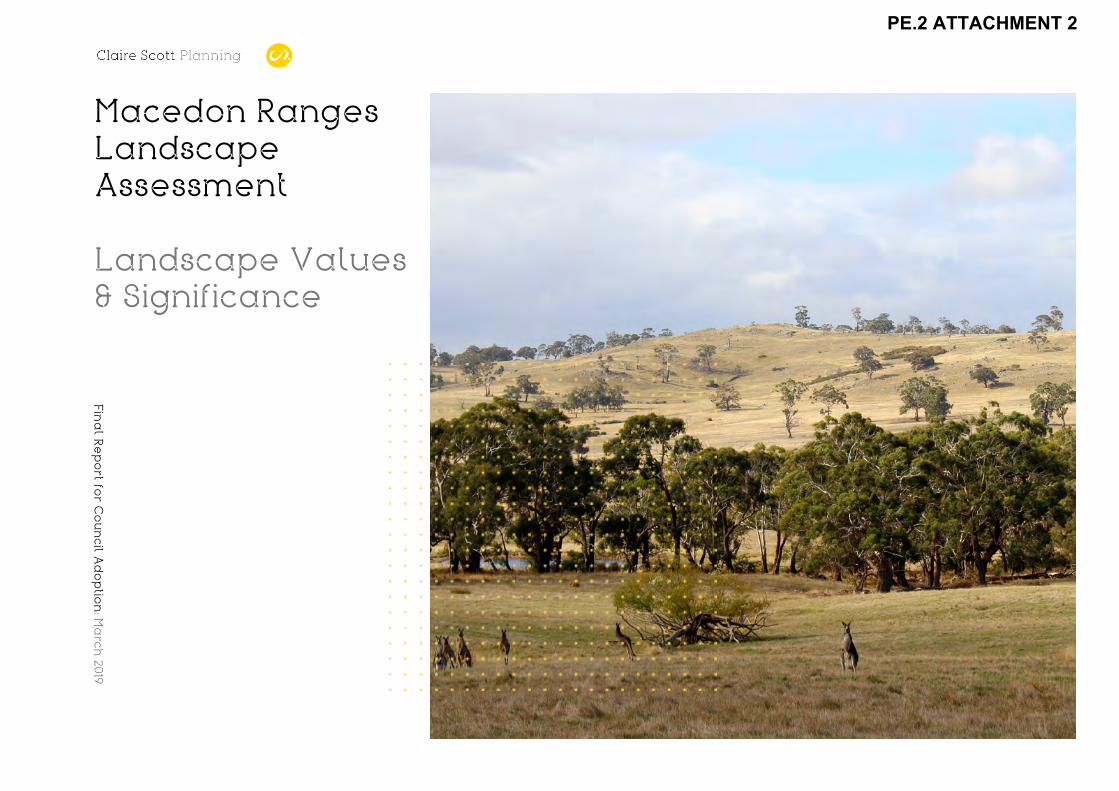
Cover image: Western edge of the McHarg Ranges from Blackhill Road, near Fordes Lane.

Contents Introduction 5
Part 1 : Existing Significant Landscape Overlays 6 SLO1 Mountain Ranges and Features 8 SLO2 Ridges and Escarpments 14 Part 2: Landscapes of Significance 20 Determining Landscape Significance 21 Levels of significance 23 Landscapes of significance for assessment 24
1. Macedon Ranges and Hanging Rock 25
2. Wombat and Lerderderg Forests 30
3. Cobaw Ranges 33
4. McHarg Ranges and granitic uplands 36
5. Mt William Ridge and Deep Creek gully 39
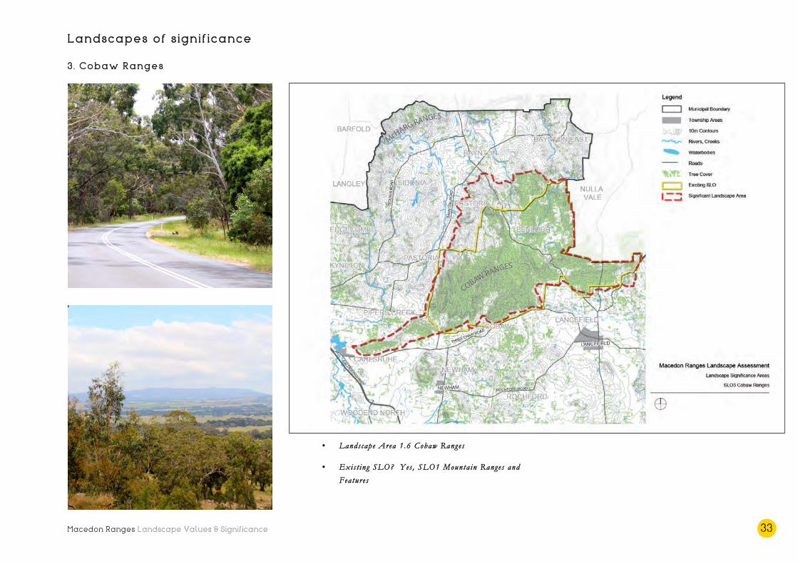
6. Volcanic cones and rises 42
Part 3: Views of Significance 55 Defining significant views 56 View significance criteria 57 Levels of significance 58 Views of significance for assessment 59
1. View from Camels Hump 60
2. View from the Major Mitchell Lookout 62
3. View from the Mt Macedon Memorial Cross 64
4. View from Mt Towrong (pending full assessment) 66
5. View from Hanging Rock 68
6. View from Gisborne Marshland Reserve 70
7. View from Mt Gisborne 72

Macedon Ranges Landscape Values & Significance 4
8. View from Golf Course Hill 74
9. View from Mt Aitken 76
Other notable views 79
Community Values Report 81
Macedon Ranges Landscape Values & Significance 5
Introduction
The landscapes of the Macedon Ranges Shire reveal a multi-layered
and diverse narrative – reflective of the area’s unique geological
morphology, land use, ecology and cultural history. They include
the statuesque Macedon Ranges - the defining landscape feature of
the Shire; the iconic Hanging Rock with its arresting vertical
pinnacles; the majestic forests of the Wombat, Lerderderg and
Cobaw Ranges; the McHarg aureole and stunning granitic uplands,
and Mt William, with its rich Wurundjeri history.
Landscapes are significant to different people for different reasons.
These reasons may include their scenic beauty, cultural heritage
value, environmental qualities, or less tangible values associated
with the place, such as memories or associations.
The visual values of landscape often provoke an emotional
response, and this ‘sense of the beautiful’ that exists in the
subjective territory of human perception is what makes the
assessment of landscape significance so challenging and often
contentious.
For the purposes of this study, landscape significance is defined as
follows:
Landscape s ign i f i cance i s the des ignat ion o f a par t i cu lar
landscape as spec ia l or impor tant ar i s ing f rom i t s cu l tura l
landscape va lues , inc luding v i sua l , cu l tura l her i tage ,
env ironmenta l , s c i en t i f i c , so c ia l and o ther va lues .
In this study, three sources of information have been used to
provide a holistic understanding of the values and significance of
the landscapes of the Macedon Ranges Shire:
1. Detailed field surveys (undertaken in April and May)
focussing on the visual values of the landscapes of the
study area.
2. Community consultation, undertaken in order to
understand the number of different ways that the
community appreciates and values their landscapes.
3. A review of secondary sources (existing information as
opposed to new research), including cultural heritage,
environmental, scientific, social and other data and
documentation.
Project Stages
The assessment and determination of significance represents Stage
4 of the project, as highlighted below. This report is the key output
from Stage 4 and forms part of a suite of reports that comprise the
overall Macedon Ranges Landscape Assessment.
Stage 1 : Inception
Stage 2: Landscape Character Assessment
Output: Landscape Character Types and Areas report
Stage 3: Identification of Community Values
Output: Community Values report (appended to Stage 4 report)
Stage 4: Landscape Significance Assessment
Output: Landscape Values & Significance report
Stage 5: Implementation Recommendations
Output: Implementation Recommendations report
This Report
As described, this report is the culmination of work undertaken
during Stage 4 of the project – the Landscape Significance
Assessment.
It includes a visual assessment of the most significant landscapes
and views in the Shire, using best practice methodology.
Part 1: Existing Significant Landscape Overlays includes a
description and analysis of the landscapes that are currently
covered by the Significant Landscape Overlay (SLO) in the
Macedon Ranges Planning Scheme. It is understood that these
overlay areas have been in place since the old planning scheme was
translated into the Victoria Planning Provisions (VPP) format,
approximately 20 years ago. Recommendations relating to each
SLO area have been made.
Part 2: Landscapes of Significance outlines the methodology for
determining landscape significance, and levels of significance. A
set of definitions and criteria are provided and explained. A
detailed assessment and rating of the landscapes of significance
follows.
Part 3: Views of Significance outlines the methodology for
determining the significance of views, and the level of significance
for those views. A list of selection considerations is provided for
deciding on viewing locations, together with a set of definitions and
assessment criteria. A detailed assessment and rating of views of
significance follows. Notable views (that are available from
viewing locations that did not meet the selection considerations)
are also listed and briefly described.
A Community Values Report, which documents work undertaken
during Stage 3 of the project is also appended.

Macedon Ranges Landscape Values & Significance 6
Part 1: Existing Significant Landscape Overlays

Macedon Ranges Landscape Values & Significance 7
Existing Significant Landscape Overlays
The Significant Landscape Overlay is currently in place in 16
locations across the Macedon Ranges Shire. There are two
Schedules - SLO1 Mountain Ranges and Features and SLO2 Ridges and
Escarpments - applying to the significant landscape areas.
The landscapes and landscape features currently covered by the
overlay are significant (to varying degrees) and the SLO should be
retained. In all cases:
• The SLO boundaries require review and justification.
The locations of the current SLO areas are based on
roads, cadastral boundaries and zoning rather than on
the extents of the significant landscape or the landscape
feature itself. In relation to determining suitable
boundaries for the SLO, recent Panel findings have
concluded that the overlay curtilage should be informed
by features of landscape significance and visibility, rather
than a cadastral base.
• A full assessment of landscape values and significance is
required for all existing SLO areas (refer to the following
section of this report). In order to prepare
comprehensive and instructive schedules for the SLO
areas, a significance assessment using best practice
methodology is required to be undertaken for each
landscape, or landscape feature. This will confirm what
is significant, how it is significant and will attribute, and
provide justification for, a level of significance for each
landscape area.
• New and additional schedules to the SLO are required.
The current two schedules attempt to cover a broad
range of landscape types, of varying levels of
significance. Many landscapes that are covered by the
SLO are not referenced or described in the
corresponding schedule, and in one case a landscape is
noted and described in detail (Mt Bullengarook) but not
covered by the overlay. The content of the schedules
requires a complete re-draft, which is possible only after
a full assessment of significance and detailed fieldwork.
The two current SLO schedules and the landscapes they cover are
described and illustrated on the following pages.
Macedon Ranges Landscape Values & Significance 8
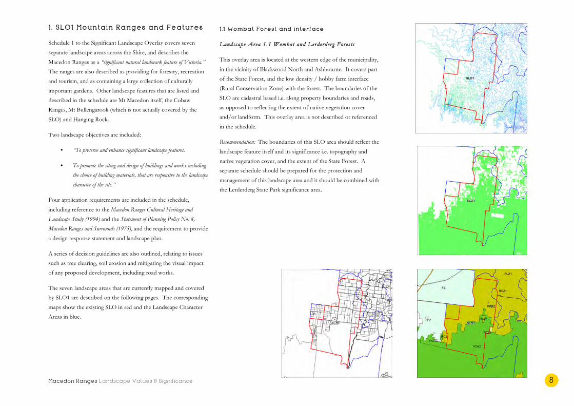
1 . SLO1 Mountain Ranges and Features
Schedule 1 to the Significant Landscape Overlay covers seven
separate landscape areas across the Shire, and describes the
Macedon Ranges as a “significant natural landmark feature of Victoria.”
The ranges are also described as providing for forestry, recreation
and tourism, and as containing a large collection of culturally
important gardens. Other landscape features that are listed and
described in the schedule are Mt Macedon itself, the Cobaw
Ranges, Mt Bullengarook (which is not actually covered by the
SLO) and Hanging Rock.
Two landscape objectives are included:
• “To preserve and enhance significant landscape features.
• To promote the siting and design of buildings and works including
the choice of building materials, that are responsive to the landscape
character of the site.”
Four application requirements are included in the schedule,
including reference to the Macedon Ranges Cultural Heritage and
Landscape Study (1994) and the Statement of Planning Policy No. 8,
Macedon Ranges and Surrounds (1975), and the requirement to provide
a design response statement and landscape plan.
A series of decision guidelines are also outlined, relating to issues
such as tree clearing, soil erosion and mitigating the visual impact
of any proposed development, including road works.
The seven landscape areas that are currently mapped and covered
by SLO1 are described on the following pages. The corresponding
maps show the existing SLO in red and the Landscape Character
Areas in blue.
1 . 1 Wombat Forest and interface
Landscape Area 1.1 Wombat and Lerderderg Fores t s
This overlay area is located at the western edge of the municipality,
in the vicinity of Blackwood North and Ashbourne. It covers part
of the State Forest, and the low density / hobby farm interface
(Rural Conservation Zone) with the forest. The boundaries of the
SLO are cadastral based i.e. along property boundaries and roads,
as opposed to reflecting the extent of native vegetation cover
and/or landform. This overlay area is not described or referenced
in the schedule.
Recommendation: The boundaries of this SLO area should reflect the
landscape feature itself and its significance i.e. topography and
native vegetation cover, and the extent of the State Forest. A
separate schedule should be prepared for the protection and
management of this landscape area and it should be combined with
the Lerderderg State Park significance area.

Macedon Ranges Landscape Values & Significance 9
1 .2 Lerderderg State Park
Landscape Area 1.1 Wombat and Lerderderg Fores t s
This overlay area covers part of the Lerderderg State Park located
between the Bullengarook plateau and Gisborne South. It does not
in fact cover Mt Bullengarook or Little Bullengarook, despite their
specific mention and description in the overlay schedule.
Recommendation: The boundaries of the SLO are cadastral based but
should reflect the full extent of the significant and heavily forested
Lerderderg State Park. An assessment of Mt Bullengarook and
Little Bullengarook is also required, and a separate SLO should be
applied to these landscape features. The Lerderderg State Park
landscape area should be covered by the same schedule as for the
Wombat Forest and interface.

Macedon Ranges Landscape Values & Significance 10
1 .3 Macedon Ranges and Hanging Rock
Landscape Areas 1 .4 Macedon Ranges and 1.5 Newham Rises
The overlay covering the Macedon Ranges is extensive, and as well
as Mt Macedon, encompasses Mt Charlie, Mt Towrong, Mt Eliza,
Mt Kerrie, Mt Teneriffe, Mt Robertson, the Black Range, Brock
Monument and Hanging Rock. Again, the overlay boundaries
follow zones, roads and property boundaries, rather than the
elements that define the significant landscape i.e. topography, break
of slope and vegetation cover. Mt Macedon and Hanging Rock are
specifically mentioned and described in the schedule, but the other
features are not referenced. Brock Monument has been described
as a ‘landscape feature’ (together with Mt Macedon, Hanging Rock
and Camels Hump) in the Macedon Ranges Localised Planning Statement
Consultation Draft (December 2017).
Recommendation: Again, the boundaries of this SLO area should be
based on the extent of the significant landscape features
themselves, rather than being dictated by a cadastral base, or
arbitrary lines on a map. A new schedule should be prepared for
this highly significant landscape, and due to the relationship
between the Macedon Ranges (and surrounding features) and
Hanging Rock, and the views of/from the features to each other
(and therefore the importance of the landscape in between), they
should remain in one SLO area.

Macedon Ranges Landscape Values & Significance 11
1 .4 Cobaw Ranges
Landscape Area 1.6 Cobaw Ranges
This overlay area applies to the majority of the heavily vegetated
Cobaw Ranges, covering public land and the adjacent Rural
Conservation zoned areas. While the steepest parts of the ranges
are covered, its full extent and foothills are not. As with other SLO
areas in the Shire, the overlay boundaries follow roads and property
boundaries, rather than taking in the full extent of the significant
landscape.
Recommendation: The overlay area should be reviewed and extended
to encompass the entire significant landscape area, and the full
extent of the mountain range to the north, east and west. The
location of native vegetation cover should also inform the overlay
boundaries. A separate schedule should be prepared for this
significant mountain range.

Macedon Ranges Landscape Values & Significance 12
1 .5 Black Hill Reserve and surrounds
Landscape Area 1.7 Grani t i c Uplands
Black Hill Reserve (also known as Langley Bushland Reserve) is
located to the north east of Kyneton and is included in this SLO
area, together with surrounding parcels of farmland. This hill and
reserve is significant as part of the metamorphic aureole of the
McHarg Ranges and includes sculptural granitic boulders, formed
by erosion. This unique landscape is not referenced in the
schedule, and the SLO area is again based on cadastral lines.
Recommendation: Black Hill forms part of the broader McHarg
Ranges and granitic uplands landscape, known for its unique
geology and clusters of spherical weathered granite. It should
therefore form part of a new, larger significant landscape area
based on the geographical and topographical extents of the
McHarg Ranges. A new schedule is required for this overlay area,
which should also encompass the cluster of hills adjacent to
Baynton Road, to the south (described next).
1 .6 Baynton Road hills
Landscape Area 1.7 Grani t i c Uplands
This SLO area covers a collection of hills either side Baynton Road,
to the east of Kyneton. The hills form the southernmost part of
the McHarg aureole and the landscape is characteristic of the
broader granitic uplands area. Once again the overlay area is
rectangular and based on roads and property boundaries as
opposed to the features of the landscape, and the collection of hills
is not referenced in the SLO schedule.
Recommendation: These hills form part of the wider granitic uplands
landscape, and should therefore be encompassed in the
aforementioned new McHarg Ranges and granitic uplands SLO
area.

Macedon Ranges Landscape Values & Significance 13
1 .7 Golf Course Hill , Woodend
Landscape Area 2.2 Campaspe Pla ins
SLO1 on adjacent maps.
This small SLO area covers part of the volcanic cone known as
Golf Course Hill at the northern entrance to the township of
Woodend. The overlay location is based on zone and property
boundaries, and includes part of the Woodend Golf Club and Rural
Conservation and Rural zoned land immediately to the north. The
north-east and south-west extremities of the volcanic cone itself are
not covered by the existing SLO. The overlay area does not
include the Avenue of Honour, which is protected by the Heritage
Overlay (and is listed on the Victorian Heritage Register). Golf
Course Hill is not referenced or described in the SLO1 schedule.
Recommendation: This SLO area should include the full extent of the
landscape feature i.e. Golf Course Hill and its setting. A new
schedule is required to cover this and other significant volcanic
cones and rises throughout the Shire.
Macedon Ranges Landscape Values & Significance 14
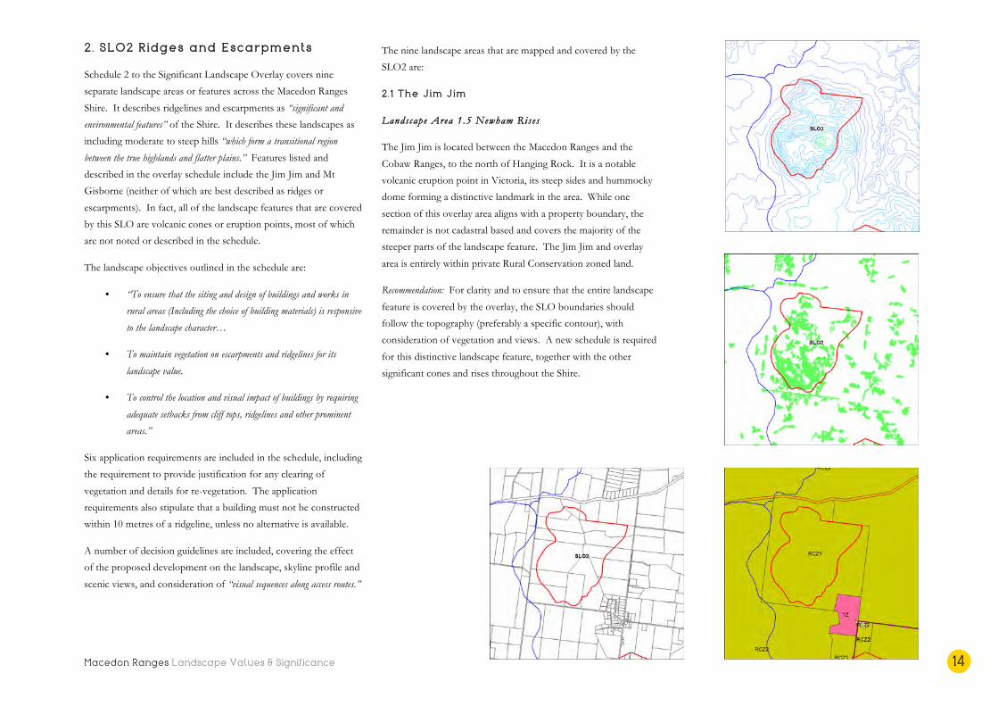
2. SLO2 Ridges and Escarpments
Schedule 2 to the Significant Landscape Overlay covers nine
separate landscape areas or features across the Macedon Ranges
Shire. It describes ridgelines and escarpments as “significant and
environmental features” of the Shire. It describes these landscapes as
including moderate to steep hills “which form a transitional region
between the true highlands and flatter plains.” Features listed and
described in the overlay schedule include the Jim Jim and Mt
Gisborne (neither of which are best described as ridges or
escarpments). In fact, all of the landscape features that are covered
by this SLO are volcanic cones or eruption points, most of which
are not noted or described in the schedule.
The landscape objectives outlined in the schedule are:
• “To ensure that the siting and design of buildings and works in
rural areas (Including the choice of building materials) is responsive
to the landscape character…
• To maintain vegetation on escarpments and ridgelines for its
landscape value.
• To control the location and visual impact of buildings by requiring
adequate setbacks from cliff tops, ridgelines and other prominent
areas.”
Six application requirements are included in the schedule, including
the requirement to provide justification for any clearing of
vegetation and details for re-vegetation. The application
requirements also stipulate that a building must not be constructed
within 10 metres of a ridgeline, unless no alternative is available.
A number of decision guidelines are included, covering the effect
of the proposed development on the landscape, skyline profile and
scenic views, and consideration of “visual sequences along access routes.”
The nine landscape areas that are mapped and covered by the
SLO2 are:
2.1 The Jim Jim
Landscape Area 1.5 Newham Rises
The Jim Jim is located between the Macedon Ranges and the
Cobaw Ranges, to the north of Hanging Rock. It is a notable
volcanic eruption point in Victoria, its steep sides and hummocky
dome forming a distinctive landmark in the area. While one
section of this overlay area aligns with a property boundary, the
remainder is not cadastral based and covers the majority of the
steeper parts of the landscape feature. The Jim Jim and overlay
area is entirely within private Rural Conservation zoned land.
Recommendation: For clarity and to ensure that the entire landscape
feature is covered by the overlay, the SLO boundaries should
follow the topography (preferably a specific contour), with
consideration of vegetation and views. A new schedule is required
for this distinctive landscape feature, together with the other
significant cones and rises throughout the Shire.

Macedon Ranges Landscape Values & Significance 15
2.2 Mt Gisborne
Landscape Area 2.1 Rural Liv ing
Mt Gisborne is described in the SLO2 schedule as an ancient
volcano, and regional landmark. It is noted that vegetation clearing
has accentuated its form, but that buildings and exotic trees on the
higher slopes are detracting from its significance. This is not aided
by the fact the SLO is located only on the very top of the hill,
encircled by Mt Gisborne Road and Woodland Drive, taking in Mt
Gisborne Reserve and adjacent rural living properties.
Recommendation: The SLO boundaries of this regional landmark
should encompass the entire volcanic feature, based on topography
with consideration of break of slope, visibility and views. A full
assessment of the values and significance of Mt Gisborne should
inform the contents of a new SLO schedule.

Macedon Ranges Landscape Values & Significance 16
2.3 Mt Aitken
Landscape Area 2.1 Rural Liv ing
Mt Aitken is a small but prominent volcanic cone located in
Gisborne South, and is visible from the Calder Freeway. It is
located in a public reserve, and the overlay boundaries follow the
Public Park and Recreation Zone boundaries. Despite its
significance as one of the best examples of an eroded volcano in
the region, Mt Aitken is not referenced in the SLO schedule.
Recommendation: The boundaries of the SLO that cover this
prominent cone should be revised to follow the feature itself as
opposed to the PPRZ parcel only. The SLO schedule for Mt
Aitken should include information gathered from a full significance
assessment of the feature, and should include other cones and rises
of similar characteristics and significance level.

Macedon Ranges Landscape Values & Significance 17
2.4 Rochford Road cone, Lancefield
Landscape Area 1.5 Newham Rises
The Rochford Road cone is a volcanic rise located south of the
Lancefield Number Two Reservoir. It is visible when travelling out
of Lancefield, as it rises out of relatively flat agricultural land. The
current SLO boundaries do not appear to be based on cadastral
lines or the location of the feature, and only partially cover the
volcanic cone.
Recommendation: A full assessment should be undertaken to
determine the significance (and significance level) of this volcanic
rise, and the SLO boundaries should cover the extent of the cone,
based on topography/break of slope. This cone should be
included in the new ‘cones and rises’ SLO schedule.
2.5 Melbourne Hill , Lancefield
Landscape Area 2.3 Lance f i e ld and Romsey Pla ins
Melbourne Hill is located south of Lancefield, next to the
Melbourne-Lancefield Road. As a result, it is highly visible to
passing traffic and is a local landmark. It is largely cleared of
vegetation, which exaggerates its dome like form. The current SLO
is based on cadastral boundaries and covers only the western half
of the volcanic rise.
Recommendation: The SLO boundaries should be revised to cover
the full extent of the landscape feature, and a significance
assessment is required. It is logical that Melbourne Hill be included
in the new SLO schedule for similar significant volcanic features.

Macedon Ranges Landscape Values & Significance 18
2.6 Joyces Road cone, Romsey
Landscape Area 2.3 Lance f i e ld and Romsey Pla ins
The Joyces Road cone is a relatively tall volcanic rise, located
immediately south of the Springfield Hills at the edge of the
volcanic plain. The current SLO has been partially determined by
cadastral boundaries, and does not cover the entire feature,
currently missing the south facing slope.
Recommendation: A full assessment is required of this volcanic cone
in order to determine the level of significance, and to better inform
the SLO schedule. Again, this volcanic rise should be grouped
with similar landscape features in the same schedule, and the new
SLO boundaries should reflect the extent of the significant
landscape feature.

Macedon Ranges Landscape Values & Significance 19
2.7 Woodend North cone
Landscape Area 2.2 Campaspe Pla ins
Refer to maps on p. 13 (SLO2).
The Woodend North cone is located west of the Calder Freeway,
just north of Russells Road. It rises out of paddocks in the
volcanic plains landscape, and is highly visible to passing traffic.
The current SLO boundaries partially follow a cadastral base, but
almost completely miss the feature itself.
Recommendation: The SLO boundaries need review and should
reflect the extent of the significant volcanic rise, based on
topography/break of slope and visibility. A full significance
assessment should inform the contents of the new ‘cones and rises’
schedule, in which this volcanic feature should be included.
2.8 Anzac Road (south), Mt Towrong
Landscape Area 1.4 Macedon Ranges
Refer to maps on p. 10 (SLO2).
This SLO area appears to be cadastral based, taking in a parcel of
Rural Conservation zoned land on the western face of Mt
Towrong, adjacent to Willimigongon Creek, and abutting the
Macedon Regional Park. It is a heavily forested area, and it is
completed surrounded by SLO1.
Recommendation: This SLO should be removed, and the parcel
should be included within the broader Macedon Ranges significant
landscape area.
2.9 Magnet Hill , Gisborne North
Landscape Area 2.1 Rural Liv ing
Magnet Hill is located on the north-eastern side of the Gisborne /
Calder Freeway intersection. It is a small volcanic hill that has been
largely covered with low-density residential development, with the
exception of its south-western face.
Recommendation: The SLO boundaries of this overlay, while they are
cadastral (zone) based, cover the extent of the landscape feature
from the break of slope. A significance assessment should inform
the contents of the new ‘cones and rises’ schedule, into which this
feature should be incorporated.

Macedon Ranges Landscape Values & Significance 20
Part 2: Landscapes of Significance
Macedon Ranges Landscape Values & Significance 21
Determining Landscape Significance
Five cultural landscape values are included in the definition of
landscape significance and an assessment of these values has been
used to determine the significance of the landscapes throughout
the study area.
1 . Visual values
The visual or aesthetic values of landscape relate to an appreciation
of their scenic beauty, and should include the consideration of all
human senses and responses. An indicator of visual or aesthetic
value may also include depiction of the landscape in poetry or
artwork, such as painting or photography.
In order to determine the overall visual value of landscapes, three
landscape components have been assessed:
Landscape features
A landscape feature is a topographic element or prominent
landmark such as a headland, mountain range or volcanic cone that
is visually dramatic and provides the landscape with its ‘wow
factor’. The prevalence or concentration of a particular landscape
attribute or vegetation type e.g. weathered granitic boulders, a stand
of River Red Gums, a proliferation of dry stone walls etc. may also
be classified as a landscape feature.
In order to assess landscape features within a landscape, the
following criterion has been developed, which informs the
determination and level of significance:
The landscape i s d i s t inc t iv e or insp irat ional for i t s landscape
f ea ture or f ea tures that a t t rac t the v i ewer and may provoke an
emot ional r e sponse .
Edges or contrasts
Edges or contrasts include the point of intersection between two
landscape elements e.g. the coastline (the point at which water
meets land); the edge of a forest or a lake; the boundary between
vegetation types or different landscape types; the intersection
between a mountain range and a plain; an incised valley etc. The
existence of edges or contrasts in the landscape provides visual
diversity, a quality associated with scenic value.
In order to assess edges and features within a landscape, the
following criterion has been developed:
The landscape i s aes the t i ca l ly compe l l ing for i t s edges or
contras t s that prov ide v i sua l var i e ty and in ter e s t for the v i ewer .
Composition
The composition of a landscape is its make-up or configuration,
including arrangements or patterns of colour, textures, features etc.
and the form, scale and unity of these and other elements.
In order to assess composition, the following criterion has been
developed:
The landscape has outs tanding compos i t ional qual i t i e s , the
combinat ion o f which ach ieve a uni f i ed whole , and prov ide the
s e t t ing or sub j e c t o f notab le v i ews .
While consideration of all cultural landscape values is important,
visual values are weighted most highly, and are the basis for
determining the significance of landscapes in a study such as this.
This is because the end-point of a landscape assessment study is
the protection and management of a significant landscape – it is
about the visual impact of development on a significant landscape,
and what is appropriate to be seen based on the landscape’s visual
qualities. In short, the purpose of a landscape assessment study is
to manage the visual impact of development on a visually
significant landscape.
Also, in most landscape assessment studies including this one,
primary research into historic, environmental, scientific, social or
other values is not undertaken, therefore the designation of a
landscape as significant on these bases alone should not be
attempted.
Primary fieldwork and the exercising of professional judgment are
undertaken in relation to visual values only. It has been well-
established in previous landscape assessments that for a landscape
to be classified as significant, it must have aesthetic or visual value.
With this is mind, it is also important to note that while the
determination of visual significance is the primary consideration in
landscape assessments, landscape significance is not only visual.
The special qualities of a landscape may also be linked to many
other responses including memories, personal experiences,
knowledge and associations – it is a challenging and often
contentious exercise as the human emotional response to aesthetic
beauty is a subjective matter, rather than a precise science.

Macedon Ranges Landscape Values & Significance 22
Determining Landscape Significance
2. Cultural heritage values
Cultural heritage value encompasses the history of the landscape
both pre and post contact, and often underpins other landscape
values. It may be that the landscape is associated with an
important historical event, figure or theme, and visual evidence
may or may not be evident.
For the purposes of this study, no primary research into cultural
heritage values was undertaken. Rather, it was concluded from
existing documentation or secondary sources such as the Victorian
Aboriginal Heritage Register, the Victorian Heritage Register, the
National Heritage List, the application of the Heritage Overlay in
the planning scheme, and other material such as historic photos,
maps etc.
3. Environmental & scientific values
Environmental and/or scientific value relates to the biological
conditions or natural attributes of the landscape, including flora
and fauna habitats, archaeological, geological attributes etc.
Secondary sources used to determine environmental and/or
scientific value included the Ramsar Convention, the use of the
Environmental Significance Overlay in the planning scheme, and
the existence of National, State or regional parks.
4. Social Values
Social value relates to a landscape being associated with a
community of cultural group, and may traverse cultural heritage
value. A landscape may have social value as an important local
landmark, or because it relates to the identity of a community, or it
may have spiritual meaning to a particular group. Determination of
social value also includes consideration of the landscape as a
tourism destination.
Secondary sources used to determine social value include Tourism
Victoria and Tourism Australia information, and various other
publications.
5. Other values
The final category encompasses any other value that is relevant to
the significance of the landscape and may include economic value,
for example.

Macedon Ranges Landscape Values & Significance 23
Levels of significance
1. Visual values
In order to determine a level of significance for each landscape, the
following rating considerations have been applied to the
aforementioned landscape components (landscape features, edges
or contrasts and composition):
Exemplary
How representat ive or i l lus t ra t ive i s the landscape (and i t s
f ea tures , edges or contras t s , and compos i t ion)? Is i t the ‘bes t ’
o f i t s t ype? Is i t exemplary wi th in the lo ca l , r eg ional or s ta t e
context?
Iconic
Is the landscape (and i t s f ea tures , edges or contras t s , and
compos i t ion) ins tant ly r e cogn izable? I s i t symbol i c for i t s
v i sua l qual i t i e s? Has the landscape been represented in ar t ,
photography , l i t e ra ture e t c .? I s i t i con i c wi th in the lo ca l ,
r eg ional or s ta t e context?
Scarce
How uncommon, rare or endangered i s the landscape (and i t s
f ea tures , edges or contras t s , and compos i t ion)? Is i t s car c e
wi th in the lo ca l , r eg ional or s ta t e context?
Significance levels
Levels of significance have been attributed to each landscape
component, and an overall significance level in relation to visual
value has been determined. The significance levels are:
• Moderate = local significance
• High = regional significance
• Exceptional = state significance or higher
The final determination of the visual significance level does not rely
on the number of ‘moderate’ or ‘high’ ratings. Rather, for example,
if a landscape is rated ‘high’ in one or more of the landscape
components, that level is the overall significance rating attributed
to the visual values of that landscape. (Just as the usual standard
for listing a place on a heritage register, for instance, is that the
place meets one or more of the set criteria.)
For the purposes of this study, an emphasis has been placed on the
most significant landscapes of the Shire. That is, detailed
significance assessments have been undertaken for those landscape
areas that were likely to be of high (regional) significance or greater.
An exception to this is some of the volcanic cones and rises that
required a full assessment of significance due to their existing SLO
status. Further, those landscape features have been considered
slightly differently to other landscape areas, as they form a
collection or ‘complex’ of cones and rises, that together, are
considered to be of high (regional) significance.
2. Other landscape values
Levels of significance were attributed to other landscape values i.e.
cultural heritage, environmental and scientific, social and other
values, based on the stated level of the significance in the secondary
source, or based on the source itself e.g. a landscape that forms
part of the Victorian Heritage Register logically has cultural
heritage values of state significance.
For the purposes of this study, which prioritises visual values, a
landscape cannot be classified as significant for its cultural heritage,
environmental, scientific, social or other values alone.
In order for a landscape to be classified as significant, it must have
visual value.
A map depicting the significant landscapes that are fully assessed in
this report is included on the following page.
A summary list of significant landscapes (and their determined
significance levels) is provided at the conclusion of this section of
the report.

Macedon Ranges Landscape Values & Significance 24
Landscape significance areas for assessment
Macedon Ranges Landscape Values & Significance 25
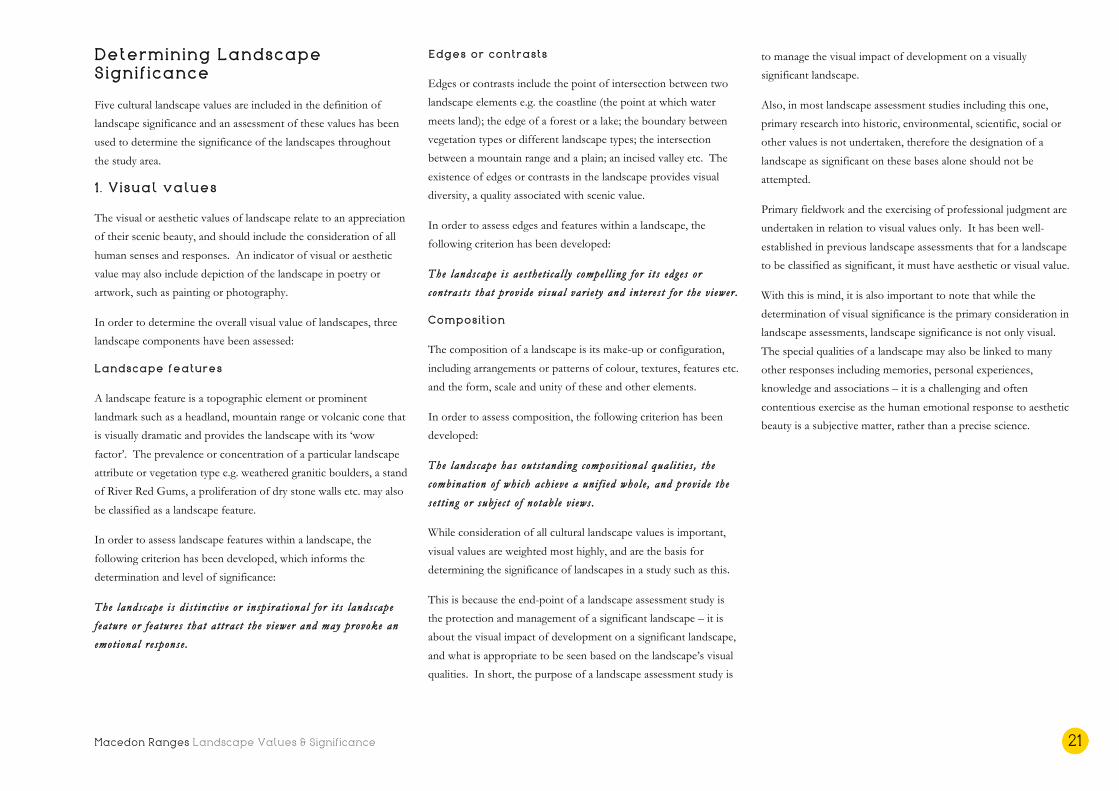
Landscapes of significance 1 . Macedon Ranges and Hanging Rock
• Landscape Areas 1 .4 Macedon Ranges and 1.5
Newham Rises
• Exist ing SLO? Yes , SLO1 Mountain Ranges and
Features

Macedon Ranges Landscape Values & Significance 26
1 . Macedon Ranges and Hanging Rock
Visual significance assessment
Landscape features
The Macedon Ranges rise abruptly from the surrounding
landscape, their ancient and heavily vegetated form dominating
near and distant views. They are the defining landscape feature of
the Shire and are exemplary within the state context. From its
highest elevation at Camels Hump, views to the north feature
Hanging Rock (Anneyelong), one of the most prominent and well
known volcanic landform features in Victoria, if not Australia. Its
arresting vertical pinnacles and circumjacent woodland contrast
dramatically with the surrounding rural landscape, and provide an
aesthetically stunning scene. Spectacular views are available over
this farmland, and back to Mt Macedon (Geboor or Geburrh), this
reciprocal visual relationship elevating the significance of both
features.
While Mt Macedon itself with its war memorial cross is perhaps the
most recognisable peak in the ranges, there are many other iconic
mountains and landscape features that form the wider massif,
including Mt Towrong, Mt Charlie, Mt Eliza, and others. Also part
of the range is Brock Monument, a volcanic eruption that formed
along with Camels Hump and Hanging Rock during the New
Volcanics period. Further, the whole range forms the southern tip
of the Great Dividing Range, the most expansive and iconic
mountain range in Victoria.
The striking mamelon of Hanging Rock creates a distinctive and
iconic silhouette. Traditional Owners have lived around Hanging
Rock for more than 26,000 years, and it was an important inter-
tribal meeting place and significant landmark on the boundary of
three different Aboriginal tribes – the Wurundjeri, Taungurung and
Dja Dja Wurrung. Both the Macedon Ranges and Hanging Rock
have been extensively represented in art, literature and music from
as early as the 1850s, adding further to their symbolism and
inspirational status within the state and national context.
Exemplary? The Macedon Ranges are an exemplary landscape
feature within the state context, and are the defining landscape
asset of the Shire. Hanging Rock is one of the most prominent
landforms of its type in the state.
I con i c? The Macedon Ranges and Hanging Rock are both
distinctive and inspirational landscape features that evoke a strong
emotional response. They are iconic within the state context.
Scarce? A geological eruption of the type that created the majestic
form of the Macedon Ranges, and the subsequent weathering and
new volcanic activity that resulted in the pinnacle formation of the
Camels Hump and Hanging Rock is uncommon and rare in the
state context.
Landscape f ea tures s i gn i f i cance ra t ing : Except ional
Edges or contrasts
The thickly vegetated landform of the Macedon Ranges contrasts
sharply with the adjacent agricultural landscape, as do the
spectacular vertical pinnacles and woodland of Hanging Rock.
These aesthetically compelling landscape features are diverse and
complex, and both include visual evidence of volcanic activity.
In the case of Hanging Rock, cooling of the geological formation
produced numerous vertical features, which have subsequently
weathered to form a remarkable visual collection of obelisks,
craggy overhangs, small caverns and boulders on the slopes of the
rock. Within the ranges, further edges and contrasts exist in the
form of numerous valleys, creeks and waterways that dissect the
mountainous landscape.
The vegetation of the Macedon Ranges provides further visual
complexity, with a widely diverse range of plant species occurring
in a very condensed zone. These native forested areas contrast
further still with the historic gardens and street trees of Mt
Macedon, featuring mature exotics that provide striking autumnal
displays, a reminder of the European influence on the landscape.
Exemplary? There are many visual edges and contrasts that occur
throughout the Macedon Ranges and Hanging Rock landscape that
are compelling and are considered exemplary within the state
context.
Iconi c? The distinct edges of the Macedon Ranges rising up from
the surrounding volcanic plain contributes to the stature and
gravitas of the landscape feature. Similarly, it is the dramatic
vertical pinnacles emerging from the adjacent farmland, and the
contrast between these edges, that make Hanging Rock instantly
recognisable. Both are iconic within the state context.
Scarce? The edges and visual contrasts described are unique to the
Macedon ranges and Hanging Rock landscape and are considered
scarce within the state context.
Landscape edges s i gn i f i cance ra t ing : Except ional
Composition
The visual composition of the Macedon Ranges and Hanging
Rock, both as individual landscape features, and together,
constitutes an outstanding natural landscape that provides the
setting and subject of many notable views. Of particular note are
the views available from a number of high points on Mt Macedon,
including the spectacular panoramic outview from Camels Hump
across the hills and rises of the agricultural middleground, and
featuring Hanging Rock and the Jim Jim, before terminating at the
thickly forested Cobaw Ranges. The elevated areas of Hanging
Rock also provide stunning panoramas, across the adjacent
eucalypt woodland and patchwork of paddocks towards the Jim
Jim, with the Cobaw Ranges on the horizon.

Macedon Ranges Landscape Values & Significance 27
The Macedon Ranges, and particularly Mt Macedon itself, are
visible from across the Shire from vast distances, and in all
directions. The imposing mountainous form is the subject of, and
backdrop to, numerous views and vistas. Both landscape features
have distinctive and recognisable silhouettes, with Hanging Rock
creating an iconic outline on the horizon when viewed from a
distance, particularly at sunrise or sunset.
Exemplary? The composition of the landscape and the views it
affords is considered exemplary within the state context.
Iconi c? It is the views of the Macedon Ranges that contribute a
strong sense of place for locals and visitors alike. Similarly, views
of Hanging Rock are captivating and unmistakable. Further, the
panoramic views from both landscape features, and between them,
are considered iconic within the state context.
Scarce? The subject matter and make-up of the landscape
features, their visual and physical relationship, and the views
available within, from and to the landscape are considered scarce
within the state context.
Landscape compos i t ion s ign i f i cance ra t ing : Except ional
Visual significance rating: Exceptional

Macedon Ranges Landscape Values & Significance 28
Other landscape values
Cultural heritage values
• Aboriginal people from the Gunung willam balug (Clark
1990: 354-5) camped on the high ground of the ranges,
and used these vantage points to protect their territory
and monitor weather and hunting conditions. Source:
Aboriginal Victoria, and Parks Victoria, via the Central
Victoria Landscape Assessment Study (2015)
• The ‘Macedon Cross’ is listed on the Victorian Heritage
Register (H1027) but refers to the original Cameron
Memorial Cross, which was dedicated in 1935, and has
since been replaced. The Macedon Avenue of Honour,
comprising 154 Pin Oak trees and associated memorial
cairns, is also listed (H2344) and is considered of
historical and aesthetic significance to the State of
Victoria. Source: Victorian Heritage Register (VHR)
• A number of historic houses and gardens of Mt
Macedon are of state significance and are listed on the
Victorian Heritage Register. These include ‘Alton’
(H0872), ‘Bolobek’ (H1316), ‘Karori’ (H2281), ‘Duneira’
(H2204) and ‘Fountainbleau’ (H1980) the former
residence of Frederick McCubbin who painted the iconic
‘The Pioneer’ (1904) in the bush near the house. Source:
VHR
• Mt Macedon has significance as a directional landmark,
including to Major Thomas Mitchell, the first European
to climb the peak in 1836. After sighting Port Phillip Bay
from the southern aspect of the peak, Mitchell named it
Mount Macedon as reference to Philip II of ancient
Macedonia. Source: Parks Victoria
• Mt Macedon is also home to an eight-metre-high survey
cairn, which was built in the 1860s as a location point for
land surveys. It is one of only three mortared stone
Geodetic Triangulation Cairns in Victoria. Source: Parks
Victoria
• Hanging Rock is located at the intersection of the tribal
lands of the three Aboriginal groups that are the
Traditional Owners of the Macedon Ranges Shire
landscapes – the Wurundjeri, Taungurung and Dja Dja
Wurrung, and the cultural and spiritual associations with
the land remain essential to the identity of the First
Peoples. Source: Registered Aboriginal Parties (RAP) area
maps
• Hanging Rock has always been a sacred place for its
Traditional Owners. When Europeans settled the region,
vast numbers of the local Aboriginal population died or
were forcibly removed from their land. In 1863, any
remaining Aboriginal people were relocated to the
Coranderrk Aboriginal Reserve (Healesville). Source:
‘What Really Happened at Hanging Rock’ by Amy Spiers
• Hanging Rock and the surrounding reserve is listed on
the Victorian Heritage Register (H2339) and is of
historical, aesthetic and social significance to the State of
Victoria. This includes the significance of the place to its
Indigenous people as part of their continuing and
developing cultural traditions. Source: VHR
• The distinctive geological formation of Hanging Rock
has attracted visitors since the 1860s for picnics,
entertainment and recreation, and has a long association
with horse racing in Victoria since that time. Source:
VHR
• The Macedon Ranges, including Hanging Rock, are also
listed on the National Trust Heritage Register (L10133).
Source: National Trust
Environmental and scientific values
• Hanging Rock is an unusual volcanic eruption point for
Victoria both in terms of its form and rock composition.
The site is an important teaching and reference site to
illustrate the influence of lava type on volcano form and
is the best example of its type in Victoria. Source:
Geological Society of Australia, Victorian Division
• The Macedon massif is significant as an ancient
mountain range formed during the Devonian Period, and
for its complex geology, which includes evidence of
folding, uplifting, erosion and further volcanic activity,
including the extrusion of Camels Hump in the late
Tertiary Period. Source: Various geology publications (refer
bibliography)
• The Macedon Ranges contain condensed zones of
diverse vegetation, only found extensively in the eastern
Victorian highlands, and normally at much higher
altitudes. These include a woodland of Snow Gum
(E.pauciflora) at Mt Macedon and Camels Hump, of
considerable botanical interest. Source: Parks Victoria and
macedonrangeflora.wordpress.com
• A number of flora and fauna reserves are located within
the Macedon Ranges, including the Mt Charlie Flora
Reserve (including Mt Teneriffe), Conglomerate Gully
Flora Reserve, T-Hill Flora Reserve, Barringo Reserve
and Stanley Park, which contain a wide diversity of plant
communities, made possible by the different aspects,
altitudes and soils. Source: Parks Victoria and
macedonrangeflora.wordpress.com
• The heavily forested ridgeline of the Macedon Ranges is
protected as Macedon Regional Park under the Crown
Land (Reserves) Act 1978.

Macedon Ranges Landscape Values & Significance 29
• The heritage, environmental and vegetation significance
of the Macedon Ranges and Hanging Rock are
recognised in the Macedon Ranges Planning Scheme
through the application of the Heritage Overlay,
Environmental Significance Overlay and Vegetation
Protection Overlay throughout the landscapes. Source:
Macedon Ranges Planning Scheme
Social values
• Hanging Rock’s mysterious associations reached
international audiences through the classic 1967 Joan
Lindsay novel and Peter Weir’s film ‘Picnic at Hanging
Rock’.
• The Victorian State Government in partnership with
Traditional Owners and the Macedon Ranges Shire
Council, has prepared a draft Localised Planning
Statement to ensure that the “state significant landscapes and
the environmental and cultural values of the Macedon Ranges are
protected…”1
• The Macedon Ranges and Hanging Rock are key
Victorian tourism destinations for artisan food and wine,
the Mt Macedon heritage gardens, hiking and sightseeing.
Visit Victoria promote Daylesford and the Macedon
Ranges together as a tourism region, and for the 2017
calendar year the region received 945,000 domestic
visitors and 104,700 international visitors, contributing a
total of approximately $345 million to the local economy.
Source: Daylesford and Macedon Ranges Regional Tourism
Board
1 Victoria State Government (DELWP), Macedon Ranges Localised Planning Statement Consultation Draft, December 2017, p. 5
Overall significance level
The Macedon Ranges and Hanging Rock landscape i s o f s ta t e
s i gn i f i cance .

Macedon Ranges Landscape Values & Significance 30
Landscapes of significance 2. Wombat and Lerderderg Forests
• Landscape Area 1.1 Wombat and Lerderderg Fores t s
• Exist ing SLO? Yes , SLO1 Mountain Ranges and
Features (Only par t o f the landscape . )

Macedon Ranges Landscape Values & Significance 31
2. Wombat and Lerderderg Forests
Visual significance assessment
Landscape features
The Wombat and Lerderderg Forests area is characterised by a
landscape of diverse and hilly topography, blanketed in thick native
vegetation. These forest areas form part of the Great Dividing
Range, and present as a heavily vegetated green backdrop to
numerous views in the southern part of the Shire. The topography
of the landscape contrasts dramatically with the adjacent volcanic
plains to the north and east, and contains features such as textured
ridges, steep gorges and a variety of indigenous vegetation. The
diversity of fauna species reflects the change in rainfall across the
landscape, and spans damp fern gullies to dry open woodland.
Exemplary? Apart from its diverse topography, including the
Pyrete Range of the Lerderderg, the key feature in this significant
landscape area is the vegetation cover. The landscape is part of one
of the largest forested areas in Central Victoria and provides a link
between the foothill forest of the Great Divide and the Box-
Ironbark forests and woodlands further north. The Wombat forest
area is considered the ‘best’ of its type within the regional context
and the Lerderderg State Park area is considered exemplary within
the state context.
Iconi c? These heavily forested landscapes are well known,
primarily within the regional context, and are considered symbolic
for their visual features at the regional (Wombat) to state
(Lerderderg) level.
Scarce? The Wombat and Lerderderg forests landscape is part of
the only remaining largely intact native forest areas in Central
Victoria and is therefore rare and endangered at a regional to state
level.
Landscape f ea tures s i gn i f i cance ra t ing : High to except ional
Edges or contrasts
The edges or contrasts throughout the Wombat and Lerderderg
landscapes are found in the vast variety of plant species and the
diverse landforms, providing visual variegation throughout. This is
most notable in the Lerderderg forest area, with the dramatic
topography of the Pyrete Range. The landscape in both areas also
forms a heavily forested edge to the cleared and semi-cleared areas
that encircle it.
Exemplary? Together with the topographical edges, including
ridges and deep gorges, the visual contrasts within these forested
landscapes are found in the 176 or more fauna species, which result
in exceptional aesthetic diversity throughout. This scenic value, of
regional (Wombat) to state (Lerderderg) significance, is heightened
during late winter and spring with stunning wildflower displays.
Iconi c? The forests of the Wombat and Lerderderg area form a
heavily vegetated edge to the semi cleared rural living areas around
Ashbourne and the volcanic plateau of Bullengarook. This
characteristic backdrop is considered iconic in a regional context.
Scarce? The history of forest clearing and the impacts of urban
encroachment render this largely intact area of native forest scarce
and endangered at the regional to state level.
Landscape edges s i gn i f i cance ra t ing : High to except ional
Composition
The Wombat and Lerderderg Forests landscape is composed of
diverse topography, incised by numerous waterways and swampy
flats, and an incredible range of native vegetation communities,
reflecting the differing climactic conditions from north to south.
The thick forest cover provides a stunning backdrop to many views
in the southern areas of the Shire, including the vista from Mt
Gisborne, across the volcanic plain to the edge of the Lerderderg in
the west. The entire forested edge provides a scenic backdrop to
the rural living and farming landscape adjacent.
Exemplary? The Wombat and Lerderderg Forests area has
outstanding compositional qualities, both from a broader landscape
point of view and in relation to the collection of textures and
colours in the diverse geomorphology and vegetation. It is
considered exemplary at a regional (Wombat) to state (Lerderderg)
level.
Iconi c? The visual qualities and composition of these forest areas
are iconic at a regional level.
Scarce? The diverse and intact composition of native plant species
combined with the dramatic topography, particularly of the
Lerderderg State Park area, make this landscape scarce at a regional
(Wombat) to state (Lerderderg) level.
Landscape compos i t ion s ign i f i cance ra t ing : High to except ional
Visual significance rating: High (Wombat) to
exceptional (Lerderderg)

Macedon Ranges Landscape Values & Significance 32
Cultural landscape values
Cultural heritage values
• The Wombat State Forest in the western section of this
significant landscape is part of the Dja Dju Wurrung
tribal land, and the eastern part of this landscape,
including the Lerderderg State Park, is Wurundjeri tribal
land. Aboriginal occupation of this area has occurred
over thousands of years, and the landscape and its
cultural and spiritual associations remain essential to the
identity of its Traditional Owners.
Environmental and scientific values
• The significance of the Wombat and Lerderderg
landscapes are recognised at a state level by their
classifications as a State Forest and State Park
respectively.
• The geology of the Lerderderg State Park is of state
significance for its Ordovician rocks and the overlaying
Permian glacial deposits and Tertiary basalt. Source:
VRO, Agriculture Victoria
• The wider Lerderderg State Park is significant for
containing the headwaters of the Lerderderg, Campaspe
and Loddon Rivers. Source: Conservation Values of the
Wombat Forest and Macedon Region (‘Conservation Values
report’, refer bibliography)
• A notable feature in the Lerderderg is the extent of
mineral springs caused by volcanic activity in the region,
which account for approximately 80% of Australia’s
mineral springs.
• A number of swampy sediment flats that occur in the
Wombat Forest are considered an endangered landscape
feature. Source: Conservation Values report
• The Vegetation Protection and Environmental
Significance Overlays (VPO and ESO) are in place
throughout this landscape, recognising the significance of
the water catchments, roadside vegetation, wildlife
corridors, Yarra Gums and living forest areas. Source:
Macedon Ranges Planning Scheme
• The Lerderderg-Wombat area was recognised by the
Land Conservation Council in 1985 as being “... the largest
and most varied of a number of forests scattered through north-
central Victoria, all of which are now isolated from each other by
cleared land” and considered the area to have a “… high
capability for nature conservation” Source: Land Conservation
Council, Victoria 1985
• As most of the landscape is public land, the Lerderderg
and Wombat Forests both contain a high level of native
vegetation cover, including upwards of 176 fauna
species. There are at least 13 threatened EVCs within
the Wombat Forest alone.
• The forests are a haven for birds and other wildlife,
including koalas, Eastern Grey Kangaroos, Swamp
Wallabies and echidnas. The endangered Wedge-tailed
Eagle also nests in the tall trees in the gullies.
Social and other values
• The parks attract visitors for picnicking, bush walking,
camping, car touring and bird watching. Source: Parks
Victoria
• The biodiversity of the region attracts both residents and
visitors, and underpins a local economy based largely on
tourism and agriculture. Source: Macedon Ranges Shire
Council
Overall significance level
The Lerderderg Fores t s landscape i s o f s ta t e s i gn i f i cance .
The Wombat Fores t s landscape i s o f r eg ional s i gn i f i cance .
Macedon Ranges Landscape Values & Significance 33
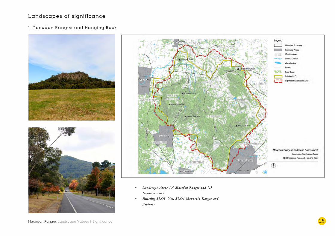
Landscapes of significance 3. Cobaw Ranges
• Landscape Area 1.6 Cobaw Ranges
• Exist ing SLO? Yes , SLO1 Mountain Ranges and
Features

Macedon Ranges Landscape Values & Significance 34
3. Cobaw Ranges
Visual significance assessment
Landscape features
The heavily forested granitic range of the Cobaw is a well-known
landscape feature of the region. It comprises diverse topography
including rolling hills and long, steep projections of elevations up
to around 700 metres. It was formed by volcanic activity
approximately 350 million years ago. The thick forest of the range
is highly visible from long distances and forms a native green
backdrop to many significant views.
Exemplary? As a landscape feature, the topographic formation of
the Cobaw Range, with its dense vegetation and scattered granitic
boulders is exemplary within the regional context.
Iconi c? While a relatively low mountain range, its contrast with the
surrounding cleared farmland, together with its dense vegetation
cover, makes the Cobaw Ranges highly visible and an iconic feature
in the landscape within the regional context. Its association with
Burke and Wills adds to its symbolic qualities.
Scarce? The granitic formation of the Cobaw batholith is
considered uncommon in the regional context – together with the
Macedon Ranges, it is a very ancient volcanic formation. The
scatterings of granitic boulders throughout the open woodland
provide unique points of difference from the better-known
Macedon Ranges.
Landscape f ea tures s i gn i f i cance ra t ing : High
Edges or contrasts
The irregular topography of the Cobaw Ranges provides a visually
interesting contrast to the flat to gently undulating surrounding
landscape. The thick forest cover also provides a stark visual
contrast with the largely cleared agricultural farmland adjacent.
Within the ranges themselves, the undulations, scattered granitic
rocks, layers of forest, and incised creeks and gullies provide
further visual variety and interest.
Exemplary? There are many visual edges or contrasts that occur
across the Cobaw Ranges landscape that are aesthetically
compelling and are considered exemplary within the regional
context. These include, but are not limited to, the break of slope
itself and the native vegetation cover.
Iconi c? The highly visible and recognisable forested edge of the
Cobaw, and its location between two distinctly different landscapes
i.e. the granitic uplands and the volcanic rises around Newham, is
considered iconic within the local to regional context.
Scarce? The native woodland cover of the ranges includes some
species that are classified as depleted or vulnerable. Together with
the unique granitic scatterings, these textural elements are
considered rare within the local to regional context.
Landscape edges s i gn i f i cance ra t ing : Moderate to h igh
Composition
The composition of the Cobaw Ranges has elements that set it
apart from other mountain ranges in the region. These include its
location between landscapes of very different character, and the
existence of granitic outcrops and weathered boulders, together
with the colours and textures of the native woodland. Its thick
forest makes the ranges a highly visible backdrop or feature of
views from across the Shire.
Exemplary? The landscape features and edges of the Cobaw
Ranges combine to achieve a visually interesting whole, which
provides a backdrop to many notable views. The composition of
the landscape is considered exemplary within the regional context.
Iconi c? Of particular significance are the views to the Cobaw
Ranges from the south and south eastern high points of Mt
Macedon and the Mt William ridge, across the rolling agricultural
landscape to the wall of dense forest. Also of note are the views
from and within the Cobaw ranges themselves, including the
experience of travelling through the tall timbers of the woodland
on the Burke and Wills Track, and the scenic vistas from the local
wineries. The role of the Cobaw Ranges in these views and their
contribution to their composition is iconic within the local to
regional context.
Scarce? The composition of this landscape and the types of views
it affords are not uncommon regionally, particularly when
compared to the Macedon ranges themselves, but are considered to
be locally significant.
Landscape compos i t ion s ign i f i cance ra t ing : Moderate to h igh
Visual significance rating: High

Macedon Ranges Landscape Values & Significance 35
Other landscape values
Cultural heritage values
• The Cobaw Ranges are located on the tribal lands of two
of the Aboriginal groups that are the Traditional Owners
of the Macedon Ranges Shire landscapes – the
Wurundjeri and the Taungurung. The occupation of the
area by Aboriginal people extends over thousands of
years, and its associations extend to spiritual attachments.
• On 23 August 1860, the Burke and Wills expedition
reached Lancefield, and then travelled through the
Cobaw Ranges on the same route that is now named
after the famed explorers. Source: Sydney Morning Herald
Environmental and scientific values
• During a geological period known as the Late Devonian
Period, granitic complexes intruded into the Ordovician
sediments in the northern part of the Shire forming the
granitic outcrop known as the Cobaw batholith, which is
visible as the Cobaw Range. Source: VRO, Agriculture
Victoria
• The Cobaw Ranges are significant for their heavy
coverage of open forest woodland, with common crown
cover including Messmate, Manna Gum, Narrow-leaved
Peppermint, Yellow Gum and to a lesser extent,
Mountain Ash. The understorey is dominated by Silver
Wattle, Blackwood and Black Wattle with a ground cover
of Bracken Fern and native grasses such as Kangaroo
grass. The Langley Bushland Reserve, managed by Parks
Victoria, exists in the Ranges. Source: VRO, Agriculture
Victoria
• While the Cobaw State Forest was historically used for
timber production, forestry has now ceased and the
majority of the area is publicly owned and protected as
an important environmental resource. Source: State Govt
• The ecological significance of the Cobaw Ranges is
recognised in the Macedon Ranges Planning Scheme
through the application of the Environmental
Significance and Vegetation Protection Overlays (ESO &
VPO). Source: MRS Planning Scheme
• The Cobaw Ranges is a habitat for threatened fauna such
as the Powerful Owl and Tuan. Source: MRRA and
MRSC
Social and other values
• The Cobaw State Forest is a popular location for trail
and mountain bike riding, and other recreational pursuits
such as hiking. There is also a rifle range on private
property within the area. Source: MRRA
• The Cobaw Ranges area is well known for its viticulture,
and is a popular destination for food and wine
enthusiasts. It was the first area in Australia to
commercially produce wine from the Lagrein grape
variety. Source: MRSC
Overall significance level
The Cobaw Ranges landscape i s o f r eg ional s i gn i f i cance .

Macedon Ranges Landscape Values & Significance 36
Landscapes of significance 4. McHarg Ranges and granitic uplands
• Landscape Area 1.7 Grani t i c Hil l s
• Exist ing SLO? Yes , SLO1 Mountain Ranges and
Features (Only over Black Hil l and grani t i c h i l l s
e i ther s ide o f Baynton Road, eas t o f Kyneton . )

Macedon Ranges Landscape Values & Significance 37
4. McHarg Ranges and granitic uplands
Visual significance assessment
Landscape features
The McHarg Ranges and granitic uplands area consists of many
stunning landscape features, including the rolling hills of the range
itself – a volcanic aureole that encircles the Cobaw and has
withstood erosion over millions of years. Also a product of
geomorphological processes, are the scatterings of granitic boulders
throughout the landscape – visually arresting sculptural formations,
eroded by spheroidal weathering, that together with the cleared
hills and relative isolation, give the landscape an ‘other worldly’
character.
Exemplary? The landscape feature of the McHarg Ranges is very
distinctive for its amphitheatre form, related to its geology and
erosion, and for the prevalence or concentration of sculptural
granitic rocks throughout the wider landscape. It is considered an
exemplar within the regional context.
Iconi c? While lesser known than the iconic Macedon Ranges or
Hanging Rock, the undulating hills, stands of remnant Eucalypts,
and sculptural boulders of the granitic uplands are a unique
collection of landscape features and are considered iconic
regionally. The Monolith at Black Hill, one of the largest spherical
weathered boulders in the state, is a visually striking and particularly
iconic landscape feature.
Scarce? While similar granitic uplands landscapes exist elsewhere
in the state and region (this landscape extends eastwards into the
Mitchell Shire), the size and prevalence of the weathered boulders
and their relationship with the McHarg aureole makes this
landscape scarce within the regional context.
Landscape f ea tures s i gn i f i cance ra t ing : High
Edges or contrasts
The unusual collection of contrasting natural features and edges
throughout this landscape provides visual diversity and makes the
granitic uplands unique and aesthetically compelling. Variance and
contrasts are found across the undulating terrain, which is incised
by numerous ephemeral creeks and waterways, often associated
with clusters of native vegetation. The granitic outcrops, some
grouped around remnant Eucalypts and others perched
precariously on ridge tops, add further to the textural and colour
differences. The edge of the McHarg Ranges and its amphitheatre
form is a stunning metamorphic contrast with the lower undulating
hills.
Exemplary? The topographical and textural differences across the
McHarg Ranges and granitic uplands landscape result in a visually
variegated and highly unique locality that is exemplary within the
regional context.
Iconi c? The forms and colours of the landscape, and particularly
the weathered granitic boulders, have been represented in many
artworks, and are considered symbolic within the regional context.
Scarce? As described, the McHarg Ranges and granitic uplands
landscape extends eastwards, and is not considered uncommon or
endangered at a state level. However, the granitic ranges and
scattered granitic boulders are the only example of such a landscape
in the Shire, and their association with the McHarg Ranges elevates
them to being regionally scarce.
Landscape edges s i gn i f i cance ra t ing : High
Composition
The McHarg Ranges and granitic uplands is composed of a
disparate collection of vastly different forms, textures and
geological features. This landscape diversity results in an unusual
but highly scenic locality that is the setting and subject of
extraordinary views and vistas.
Exemplary? The McHarg Ranges and granitic uplands area has
outstanding compositional qualities, both as a broader landscape
and in relation to the collection of colours and textures in the
cleared paddocks and hills, rocky outcrops and vegetation. The
composition of the landscape is considered a regional exemplar.
Iconi c? The visual composition of the landscape is considered
iconic within the local to regional context, and is the subject of
numerous scenic vistas, predominantly from within the landscape
to other hills and peaks of the McHarg, and close views of
captivating granitic formations. The heavily forested Cobaw
Ranges provides a contrasting backdrop to many of the vistas
available from within the landscape.
Scarce? The unusual composition of landscape features within the
granitic uplands is certainly scarce at a local level, and the existence
of the unique McHarg aureole elevates the scarcity of the
composition to regionally significant.
Landscape compos i t ion s ign i f i cance ra t ing : High
Visual significance rating: High

Macedon Ranges Landscape Values & Significance 38
Other landscape values
Cultural heritage values
• Aboriginal people occupied the landscape many
thousands of years ago and have a spiritual connection to
the landscape and landscape features. The McHarg
Ranges and granitic uplands are located on the tribal
lands of one of the Aboriginal groups that are the
Traditional Owners of the Macedon Ranges Shire
landscapes – the Taungurung.
• The landscape and its granitic formations have long been
recognised as unique, as evidenced in this description in
the McIvor Times in 1912: “Situated about 7 miles from
Heathcote in a south-easterly direction, is a spot, the scenic beauties
of which, at this time of the year stand above all other in a class of
their own. Here nature has decked in floods of pink and white, in
wonderful yet orderly confusion, the family hills of Tooborac. She
has contrasted the product of her mightiest powers – those rugged
and stupendous eminences of the Tooborac Range – with her most
delicately fashioned artistic handiwork.”
Environmental and scientific values
• The environmental and remnant vegetation significance
of the landscape is recognised in the Macedon Ranges
Planning Scheme through the application of the
Environmental Significance and Vegetation Protection
Overlays (ESO and VPO). Source: Macedon Ranges
Planning Scheme
• The landscape is significant for its unique geology,
including the metamorphic aureole of the McHarg
Ranges, and the Baynton Granodiorite terrain. Source:
VRO, Agriculture Victoria
• The geologically significant sculptural boulders of granite
that are evident across the landscape are a product of
millions of years of erosion, known as spheroidal
weathering. Source: VRO, Agriculture Victoria
• Black Hill reserve contains possibly the largest weathered
granitic boulder in Victoria, known as ‘The Monolith’.
Source: Various locally produced papers and essays (refer
bibliography)
• The McHarg Ranges are known to be a migratory path
for bird species including the Swift Parrot (en route to
the Box-ironbark Forests and Woodlands further north),
and home to the endangered Wedge-tailed Eagle (four
eyries are said to exist in the ranges). Source: Submission
on windfarms by local resident (and sculptor) David Maughan
Social and other values
• Many artists are drawn to the McHarg Ranges and
surrounds for inspiration, and many artists’ studios are
located within this landscape. Artists who have depicted
the landscape in painting or sculpture include Drew
Gregory, Ted May, Peter Russell-Clarke, Deborah
Wright, Max Meldrum, Les Kossatz and David
Maughan.
Overall significance level
The McHarg Ranges and Grani t i c Uplands landscape i s o f
r eg ional s i gn i f i cance .

Macedon Ranges Landscape Values & Significance 39
Landscapes of significance 5. Mt William (Wil-im-ee Moor-ring) Ridge and Deep Creek
• Landscape Area 1.8 Mt Wil l iam Ridge and Deep
Creek
• Exist ing SLO? No

Macedon Ranges Landscape Values & Significance 40
5. Mt William (Wil-im-ee Moor-ring) Ridge and Deep Creek
Visual significance assessment
Landscape features
This landscape of significance at the eastern edge of the Shire
comprises the iconic Mt William ridge and the foothills of the
range extending south and west, where they meet the dramatically
incised Deep Creek gully. The terrain is very steep in areas,
particularly where it drops off at its western edge at Deep Creek,
and this combination of a high ridge, rolling hills and a steep
descent into a flowing creek makes this a visually captivating
landscape. The cultural heritage significance of the Mt William
ridge and its connection to ancient tribal processes of the
Wurundjeri adds a powerful dimension to the significance of the
place.
Exemplary? The landscape features of Mt William Ridge and
Deep Creek gully, together with the rolling foothills of the range
are exemplary within the region. The Mt William Range is visual
evidence of a unique geomorphological process, which produced
its unique ‘greenstone’ geology, and the existence of remnant
woodland vegetation on many of the hilltops adds further to its
visual significance.
I con i c? The long crested ridgeline of Mt William is an uncommon
geomorphological landscape feature, which is iconic at a regional
level. It is distinctive for its form and height (approximately 700
metres), and is visible from across the Shire, providing a
terminating backdrop to many long range views. The demarcation
of the edge of the volcanic plain by Deep Creek gully is considered
equally iconic.
Scarce? A geological formation such as the Mt William ridge and
the adjacent foothills and deep, steep gully is considered
uncommon and rare in the regional context.
Landscape f ea tures s i gn i f i cance ra t ing : High
Edges or contrasts
The Mt William ridge and deep creek landscape area occurs at an
‘edge’ or transition point between landscape character types - the
volcanic plain terminates dramatically at Deep Creek and the
landscape beyond could not be more contrasting. Other visual
contrasts or edges that occur in the landscape include the
numerous additional incised watercourses and gullies, lined with
remnant native trees, and the contrast between the cleared rolling
hills in parts, and the heavily forested hilltops in others.
Exemplary? The many and varied visual edges that occur
throughout this landscape make it aesthetically compelling at a
regional level. These elements in the landscape – the ridge, hills,
gullies and native vegetation, and particularly the majestic River
Red Gums – provide visual variety and interest and add to the
overall scenic beauty of the landscape.
Iconi c? The Mt William Ridge and Deep Creek landscape forms
an iconic edge between the Lancefield and Romsey Plain and the
hilly uplands to the east, and is considered iconic within the
regional context.
Scarce? Some of the visual contrasts and edges described occur
throughout the region, however, the distinctive formation of the
Mt William ridge and the close proximity and visual relationship
between the contrasting landscape features makes this type of
landscape uncommon overall, at the regional level.
Landscape edges s i gn i f i cance ra t ing : High
Composition
The unique arrangement of landscape features and its existence at
the edge of the volcanic plain, makes for numerous stunning views,
both from and to the Mt William ridge and Deep Creek area.
These include from the Lancefield and Romsey Plains eastwards to
the range and rolling hills, and from the high points of the Mt
William ridge westwards, over classic agricultural landscape.
Exemplary? The unique features and concentration of edges
within this significant landscape combine to achieve a visually
interesting whole, which provides the setting and subject of notable
views. The composition of the landscape is considered exemplary
within the regional context.
Iconi c? Of particular note are the views from the townships of
Lancefield and Romsey, and the adjacent plains towards the east,
where the rolling hills climb to the pinnacle of Mt William ridge.
When mist hangs over the valley, these views are described as even
more atmospheric and are cherished by the local community. Also
of significance are the outviews from the high points of the Mt
William Range, over the agricultural land and volcanic cones in the
west, and as far as other iconic landscapes including the Cobaw
Range and Mt Macedon. These views are considered iconic at a
regional level.
Scarce? The composition of the landscape and the types of views
that it affords are considered uncommon at a regional level.
Landscape compos i t ion s i gn i f i cance ra t ing : High
Visual significance rating: High

Macedon Ranges Landscape Values & Significance 41
Other landscape values
Cultural heritage values
• The Mt William Ranges are located on the tribal lands of
one of the Aboriginal groups that are the Traditional
Owners of the Macedon Ranges Shire landscapes – the
Wurundjeri.
• The Mt William stone hatchet quarry is on the National
Heritage List (Place ID 105936). It is noted as
exceptional in the course of Australia’s cultural history.
Source: Australian Heritage Database (AHD)
• The greenstone hatchet heads from Wil-im-ee Moor-ring
were highly sought after and Aboriginal people travelled
great distances for them, bringing items to trade. As a
result Mt William became one of the most intensively
worked quarries in south eastern Australia. Source: AHD
• Detailed ethnographic records exist outlining custodial
control of the quarry by Billi-billeri of the Wurundjeri.
Such a record is uncommon in Australia and makes this a
place of outstanding significance. Source: AHD
• In 2012 the Macedon Ranges Shire Council formally
transferred the land title, ownership and management of
Mt William back to its Traditional Owners. The
Wurundjeri Tribe Land Cultural Heritage Council now
own these lands permanently to ensure their
preservation. Source: MRSC
• At the quarry area itself, there are 268 pits and shafts,
some several metres deep. There are also 34 discrete
production areas where the stone was shaped into
hatchet heads. Source: AHD
Environmental and scientific values
• The geology and geomorphology of the Mt William
range is considered extremely complex – too complex to
map in detail. In summary, it is composed of Cambrian
rock, with the ridge being of Cambrian metabasalt
‘greenstone’. On the western side of the landscape, there
are hills of chert and black shale with colluvial fans from
both the Quaternary and Tertiary age. Source: VRO,
Agriculture Victoria
• The dominant vegetation species found on the crest of
the Mt William ridge include Narrow-leafed Peppermint,
Broad-leafed Peppermint, Manna Gum, Messmate and
Long-leafed Box. These species, along with Swamp
Gum and Candlebark occur on the side slopes. On the
drainage depressions, Manna Gum, Swamp Gum,
Candlebark and River Red Gum occur in woodland
formation. Source: VRO
• The Environmental Significance and Vegetation
Protection Overlays (ESO and VPO) are in place
throughout the landscape, indicating the significance of
the environment, roadside vegetation and wildlife
corridors. Source: Macedon Ranges Planning Scheme
Social and other values
• In 2012 the Wurundjeri Council collected stone from the
quarry to make axes with which to build a Koorong
(canoe) from a River Red Gum at Plenty Gorge to
continue practising their traditional culture. Access to
the quarry requires the permission of the Wurundjeri
Council. Annual public excursions to the site are usually
arranged, associated with the Lancefield Megafauna
Festival. Source: aboriginalhistoryofyarra.com.au
Overall significance level
The Mt Wil l iam r idge and Deep Creek landscape i s o f r eg ional
s i gn i f i cance .
“For the Wurundjer i community the natura l wor ld i s a l so a
cu l tura l wor ld ; there fore the Wurundjer i peop le have a spec ia l
in ter es t in preserv ing not jus t the i r cu l tura l ob j e c t s , but the
natura l landscapes o f cu l tura l importance . The
acknowledgement o f broader a t t r ibutes o f the landscape as
cu l tura l va lues that r equire pro t e c t ion ( encompass ing , among
o ther th ings , a var i e ty o f landforms, e co log i ca l n i ches and
habi ta ts as we l l as cont inuing cu l tura l prac t i c e s and
archaeo log i ca l mater ia l ) i s e s s ent ia l to the ident i ty and
we l lbe ing o f the Wurundjer i peop le .”
Source : Wurundjer i Tr iba l Counc i l webs i t e

Macedon Ranges Landscape Values & Significance 42
Landscapes of significance 6. Volcanic Cones and Rises
This ‘landscape of significance’ is better described as a collection of
landscape features comprising individual volcanic cones and rises
that occur throughout the study area, primarily within the Central
Volcanic Plains Landscape Character Type.
Much of the Macedon Ranges Shire landscape has been shaped by
volcanic activity and this is evidenced by the existence of some of
the most iconic volcanic cones and rises to be found in the region.
These volcanic features emerge dramatically, mostly from the open
and slightly undulating volcanic plains. Many of them are visible
on the horizon from long distances, and are compelling and
fascinating reminders of ancient volcanic activity.
The cones and rises included in this volcanic complex are:
• The Jim Jim
• Mt Bullengarook and Little Bullengarook
• Mt Gisborne
• Mt Aitken
• Golf Course Hill and surrounds, Woodend
• Melbourne Hill, Lancefield
• Rochford Road cone, Lancefield
• Joyces Road cone, Romsey
• Woodend North cone
• Magnet Hill
Depic t ed on th i s map: Melbourne Hil l , the Roch ford Road
cone and the Joyce s Road cone
Macedon Ranges Landscape Values & Significance 43
Landscapes of significance 6. Volcanic Cones and Rises
Depic t ed on th i s map: Mt Bul l engarook, Lit t l e Bul l engarook, Mt Gisborne , Mt Aitken and Magnet Hil l ( in New Gisborne)

Macedon Ranges Landscape Values & Significance 44
Landscapes of significance 6. Volcanic Cones and Rises Depic t ed on th i s map: Gol f Course Hil l , the J im J im and the
Woodend North cone
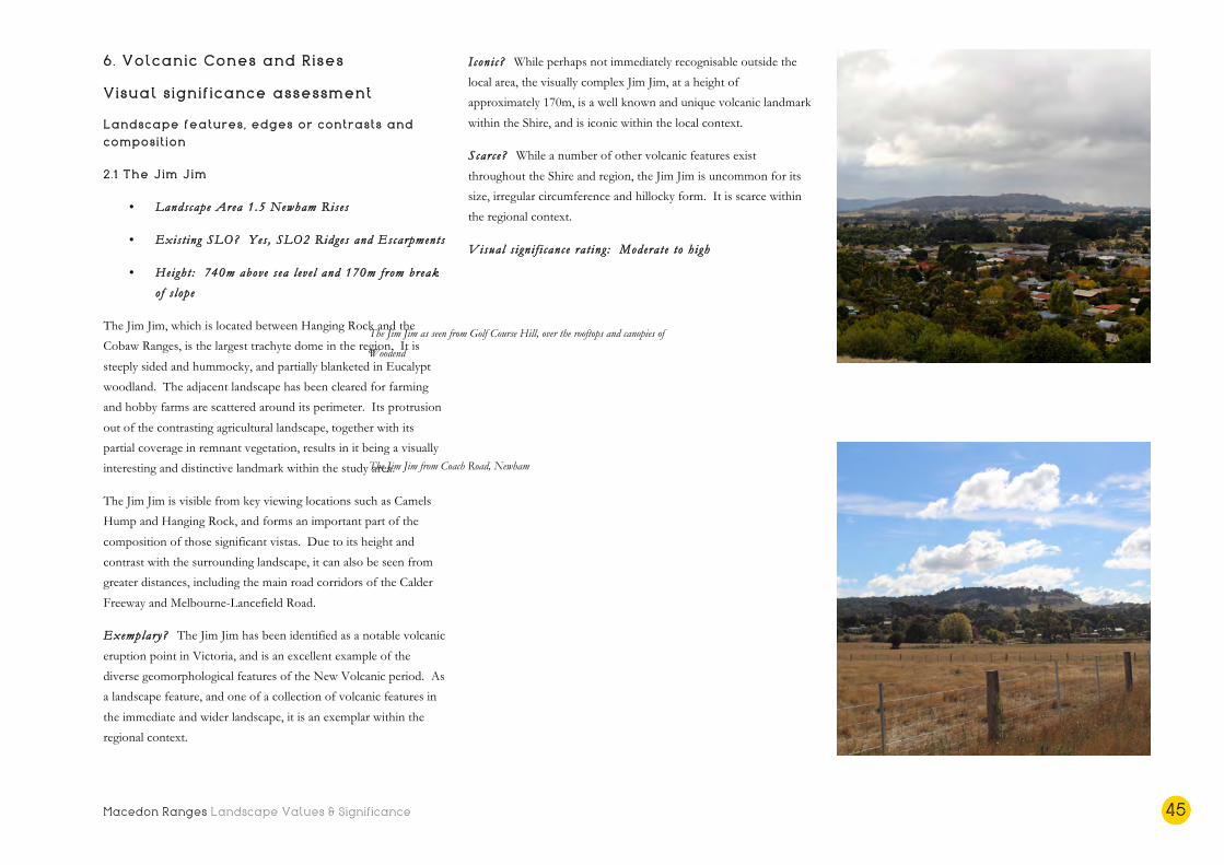
Macedon Ranges Landscape Values & Significance 45
6. Volcanic Cones and Rises
Visual significance assessment
Landscape features, edges or contrasts and
composition
2.1 The Jim Jim
• Landscape Area 1.5 Newham Rises
• Exist ing SLO? Yes , SLO2 Ridges and Escarpments
• Height : 740m above s ea l eve l and 170m from break
o f s lope
The Jim Jim, which is located between Hanging Rock and the
Cobaw Ranges, is the largest trachyte dome in the region. It is
steeply sided and hummocky, and partially blanketed in Eucalypt
woodland. The adjacent landscape has been cleared for farming
and hobby farms are scattered around its perimeter. Its protrusion
out of the contrasting agricultural landscape, together with its
partial coverage in remnant vegetation, results in it being a visually
interesting and distinctive landmark within the study area.
The Jim Jim is visible from key viewing locations such as Camels
Hump and Hanging Rock, and forms an important part of the
composition of those significant vistas. Due to its height and
contrast with the surrounding landscape, it can also be seen from
greater distances, including the main road corridors of the Calder
Freeway and Melbourne-Lancefield Road.
Exemplary? The Jim Jim has been identified as a notable volcanic
eruption point in Victoria, and is an excellent example of the
diverse geomorphological features of the New Volcanic period. As
a landscape feature, and one of a collection of volcanic features in
the immediate and wider landscape, it is an exemplar within the
regional context.
Iconi c? While perhaps not immediately recognisable outside the
local area, the visually complex Jim Jim, at a height of
approximately 170m, is a well known and unique volcanic landmark
within the Shire, and is iconic within the local context.
Scarce? While a number of other volcanic features exist
throughout the Shire and region, the Jim Jim is uncommon for its
size, irregular circumference and hillocky form. It is scarce within
the regional context.
Visual s i gn i f i cance ra t ing : Moderate to h igh
The Jim Jim as seen from Golf Course Hill, over the rooftops and canopies of
Woodend
The Jim Jim from Coach Road, Newham
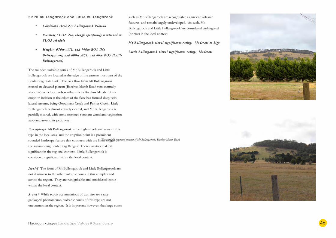
Macedon Ranges Landscape Values & Significance 46
2.2 Mt Bullengarook and Little Bullengarook
• Landscape Area 2.5 Bul l engarook Plateau
• Exist ing SLO? No, though spec i f i ca l l y ment ioned in
SLO2 schedule
• Height : 670m ASL and 140m BOS (Mt
Bul l engarook) and 600m ASL and 80m BOS (Lit t l e
Bul l engarook)
The rounded volcanic cones of Mt Bullengarook and Little
Bullengarook are located at the edge of the eastern most part of the
Lerderderg State Park. The lava flow from Mt Bullengarook
caused an elevated plateau (Bacchus Marsh Road runs centrally
atop this), which extends southwards to Bacchus Marsh. Post-
eruption incision at the edges of the flow has formed deep twin
lateral streams, being Goodmans Creek and Pyrites Creek. Little
Bullengarook is almost entirely cleared, and Mt Bullengarook is
partially cleared, with some scattered remnant woodland vegetation
atop and around its periphery.
Exemplary? Mt Bullengarook is the highest volcanic cone of this
type in the local area, and the eruption point is a prominent
rounded landscape feature that contrasts with the linear ridges of
the surrounding Lerderderg Ranges. These qualities make it
significant in the regional context. Little Bullengarook is
considered significant within the local context.
Iconi c? The form of Mt Bullengarook and Little Bullengarook are
not dissimilar to the other volcanic cones in this complex and
across the region. They are recognisable and considered iconic
within the local context.
Scarce? While scoria accumulations of this size are a rare
geological phenomenon, volcanic cones of this type are not
uncommon in the region. It is important however, that large cones
such as Mt Bullengarook are recognisable as ancient volcanic
features, and remain largely undeveloped. As such, Mt
Bullengarook and Little Bullengarook are considered endangered
(or rare) in the local context.
Mt Bul l engarook v i sua l s i gn i f i cance ra t ing : Moderate to h igh
Lit t l e Bul l engarook v i sua l s i gn i f i cance ra t ing : Moderate
Little Bullengarook across the farmland landscape near Haires Lane
The partially vegetated summit of Mt Bullengarook, Bacchus Marsh Road
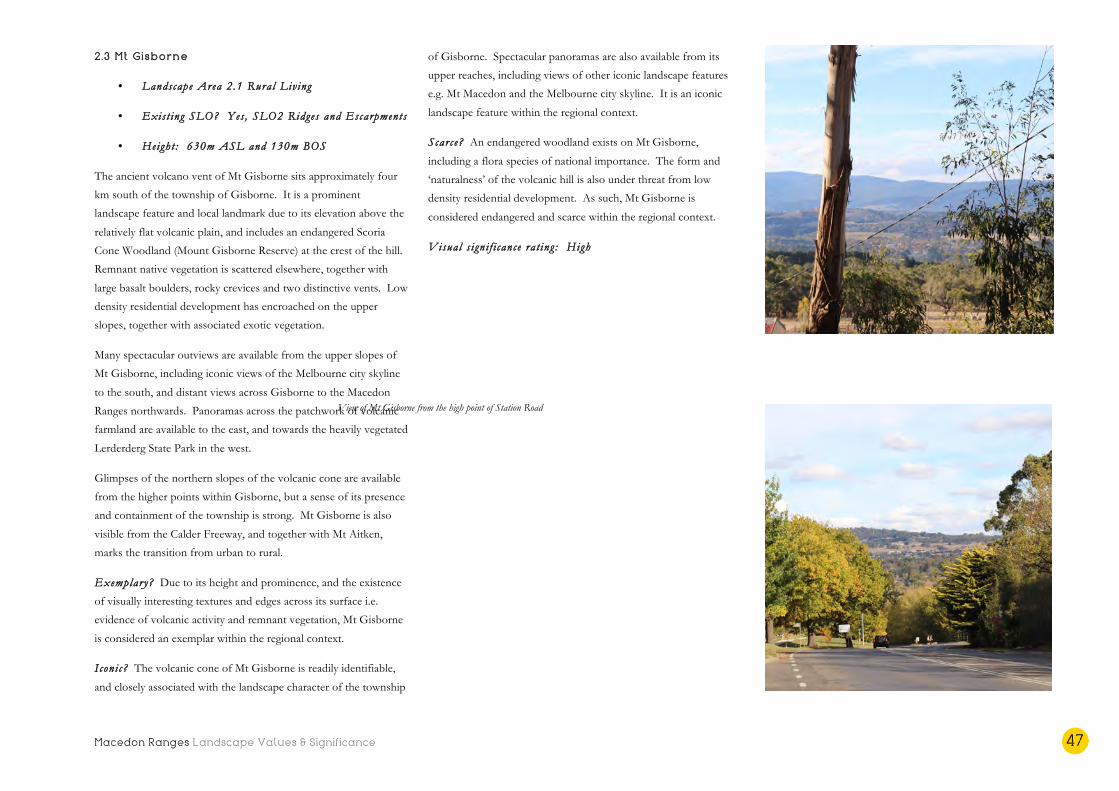
Macedon Ranges Landscape Values & Significance 47
2.3 Mt Gisborne
• Landscape Area 2.1 Rural Liv ing
• Exist ing SLO? Yes , SLO2 Ridges and Escarpments
• Height : 630m ASL and 130m BOS
The ancient volcano vent of Mt Gisborne sits approximately four
km south of the township of Gisborne. It is a prominent
landscape feature and local landmark due to its elevation above the
relatively flat volcanic plain, and includes an endangered Scoria
Cone Woodland (Mount Gisborne Reserve) at the crest of the hill.
Remnant native vegetation is scattered elsewhere, together with
large basalt boulders, rocky crevices and two distinctive vents. Low
density residential development has encroached on the upper
slopes, together with associated exotic vegetation.
Many spectacular outviews are available from the upper slopes of
Mt Gisborne, including iconic views of the Melbourne city skyline
to the south, and distant views across Gisborne to the Macedon
Ranges northwards. Panoramas across the patchwork of volcanic
farmland are available to the east, and towards the heavily vegetated
Lerderderg State Park in the west.
Glimpses of the northern slopes of the volcanic cone are available
from the higher points within Gisborne, but a sense of its presence
and containment of the township is strong. Mt Gisborne is also
visible from the Calder Freeway, and together with Mt Aitken,
marks the transition from urban to rural.
Exemplary? Due to its height and prominence, and the existence
of visually interesting textures and edges across its surface i.e.
evidence of volcanic activity and remnant vegetation, Mt Gisborne
is considered an exemplar within the regional context.
Iconi c? The volcanic cone of Mt Gisborne is readily identifiable,
and closely associated with the landscape character of the township
of Gisborne. Spectacular panoramas are also available from its
upper reaches, including views of other iconic landscape features
e.g. Mt Macedon and the Melbourne city skyline. It is an iconic
landscape feature within the regional context.
Scarce? An endangered woodland exists on Mt Gisborne,
including a flora species of national importance. The form and
‘naturalness’ of the volcanic hill is also under threat from low
density residential development. As such, Mt Gisborne is
considered endangered and scarce within the regional context.
Visual s i gn i f i cance ra t ing : High
View of the Macedon Ranges from near the summit of Mt Gisborne, Woodland
Drive
View of Mt Gisborne from the high point of Station Road
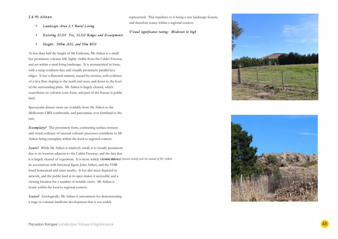
Macedon Ranges Landscape Values & Significance 48
2.4 Mt Aitken
• Landscape Area 2.1 Rural Liv ing
• Exist ing SLO? Yes , SLO2 Ridges and Escarpments
• Height : 500m ASL and 50m BOS
At less than half the height of Mt Gisborne, Mt Aitken is a small
but prominent volcanic hill, highly visible from the Calder Freeway
and set within a rural living landscape. It is asymmetrical in form,
with a steep southern face and visually prominent parallel lava
ridges. It has a flattened summit, caused by erosion, with evidence
of a lava flow sloping to the north and west, and down to the level
of the surrounding plain. Mt Aitken is largely cleared, which
exacerbates its volcanic cone form, and part of the feature is public
land.
Spectacular distant views are available from Mt Aitken to the
Melbourne CBD southwards, and panoramas over farmland to the
east.
Exemplary? The prominent form, contrasting surface textures
and visual evidence of unusual volcanic processes contribute to Mt
Aitken being exemplary within the local to regional context.
Iconi c? While Mt Aitken is relatively small, it is visually prominent
due to its location adjacent to the Calder Freeway, and the fact that
it is largely cleared of vegetation. It is more widely known due to
its associations with historical figure John Aitken, and the VHR
listed homestead and ruins nearby. It has also been depicted in
artwork, and the public land at its apex makes it accessible and a
viewing location for a number of notable views. Mt Aitken is
iconic within the local to regional context.
Scarce? Geologically, Mt Aitken is uncommon for demonstrating
a stage in volcanic landform development that is not widely
represented. This translates to it being a rare landscape feature,
and therefore scarce within a regional context.
Visual s i gn i f i cance ra t ing : Moderate to h igh
The cleared, rounded form of Mt Aitken from Cadana Road
Visual evidence of volcanic activity near the summit of Mt Aitken

Macedon Ranges Landscape Values & Significance 49
2.5 Golf Course Hill
• Landscape Area 2.2 Campaspe and Loddon Pla ins
• Exist ing SLO? Yes , SLO1 Mountain Ranges and
Features
• Height : 620 ASL and 40m BOS
Golf Course Hill is a prominent volcanic rise at the northern
entrance to Woodend. Together with the Avenue of Honour, it is
an important part of the gateway experience to the township from
the north. It is also important as the point of transition between
two Landscape Character Types – the Central Volcanic Plain,
which characterises the landscape to the north of the settlement,
and the Uplands which occurs from this point, southwards.
The volcanic cone itself is grassy and largely cleared of native
vegetation. There is evidence of volcanic activity on the surface of
the hill, with rocky depressions and ledges high up on its eastern
face. The Woodend Golf Course occupies the majority of the
higher slopes of the volcanic cone, with manicured fairways and
exotic vegetation. The heavily forested southern side of the hill,
which is overrun with ivy and other invasive species, forms part of
the forested backdrop to Woodend, when viewed from the south.
The lower northern slopes of the hill are partially cleared paddocks
with important stands of remnant Eucalypt woodland. This
northern foreground setting to Golf Course Hill is equally
significant in providing open views to the hill from the north, and
as a key element in the transition from the open rural landscape,
north of the settlement to the more built up township.
Spectacular vistas are available from Golf Course Hill, over the
vegetation and rooftops of the township towards the Macedon
Ranges in the south east, and Hanging Rock and the Jim Jim to the
north east. Long range outviews are also available to the north and
north east, over the foreground setting to the hill and across the
volcanic landscape to the heavily vegetated Cobaw Ranges.
Exemplary? The association of Golf Course Hill with the Avenue
of Honour and the gateway experience into Woodend, together
with its undeveloped northern setting, which includes remnant
woodland vegetation, makes it an exemplar within the regional
context.
Iconi c? Due to its prominent location, surrounding landscape and
proximity to the Woodend township, Golf Course Hill is instantly
recognizable locally and considered iconic within the local to
regional context. This rating is further reinforced by its
accessibility and the spectacular panoramas available from its high
points to landscape features of state and regional significance.
Scarce? Golf Course Hill and its surrounding landscape and
associations are unique and uncommon when compared to other
volcanic features within this complex. It is considered scarce
within the regional context.
Visual s i gn i f i cance ra t ing : Moderate to h igh
The grassy, cleared form of Golf Course Hill from the Woodend Avenue of
Honour
Remnant stands of Eucalypts contribute to the significant northern setting of Golf
Course Hill
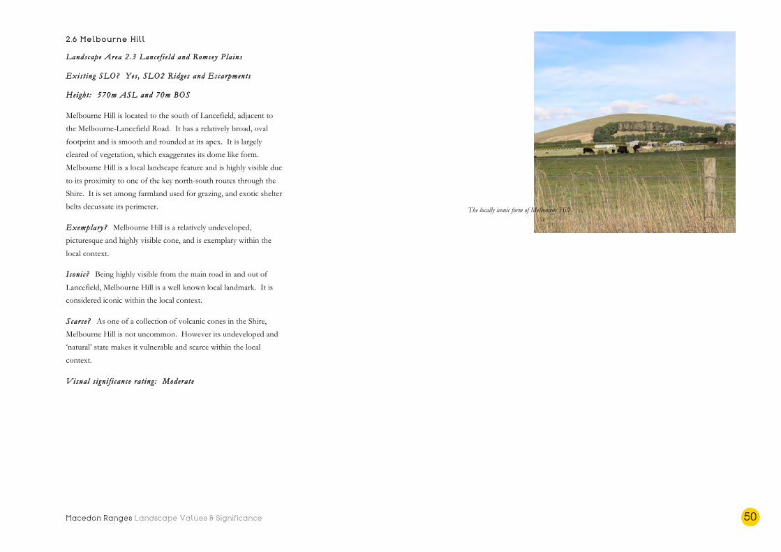
Macedon Ranges Landscape Values & Significance 50
2.6 Melbourne Hill
Landscape Area 2.3 Lance f i e ld and Romsey Pla ins
Exis t ing SLO? Yes , SLO2 Ridges and Escarpments
Height : 570m ASL and 70m BOS
Melbourne Hill is located to the south of Lancefield, adjacent to
the Melbourne-Lancefield Road. It has a relatively broad, oval
footprint and is smooth and rounded at its apex. It is largely
cleared of vegetation, which exaggerates its dome like form.
Melbourne Hill is a local landscape feature and is highly visible due
to its proximity to one of the key north-south routes through the
Shire. It is set among farmland used for grazing, and exotic shelter
belts decussate its perimeter.
Exemplary? Melbourne Hill is a relatively undeveloped,
picturesque and highly visible cone, and is exemplary within the
local context.
Iconi c? Being highly visible from the main road in and out of
Lancefield, Melbourne Hill is a well known local landmark. It is
considered iconic within the local context.
Scarce? As one of a collection of volcanic cones in the Shire,
Melbourne Hill is not uncommon. However its undeveloped and
‘natural’ state makes it vulnerable and scarce within the local
context.
Visual s i gn i f i cance ra t ing : Moderate
The locally iconic form of Melbourne Hill

Macedon Ranges Landscape Values & Significance 51
2.7 Rochford Road cone
• Landscape Area 2.3 Lance f i e ld and Romsey Pla ins
• Exist ing SLO? Yes , SLO2 Ridges and Escarpments
• Height : 630m ASL and 50m BOS
The Rochford Road cone is a prominent volcanic rise, just south of
the Lancefield Number Two Reservoir. It is visible on the horizon
from a long distance when travelling out of Lancefield, as it rises
out of relatively flat agricultural land. It is grassy and largely
cleared, with the exception of a remnant stand of Eucalypts near its
apex and shelter belts on its lower reaches. Due to its contrast with
the surrounding farmland, it creates visual interest in the landscape,
along with the other volcanic rises in this complex.
Exemplary? The Rochford Road cone contrasts dramatically with
the surrounding landscape and marks a transition point to the
Volcanic Plains Character Type. It is considered exemplary within
the local context.
Iconi c? The Rochford Road rise is a classic rounded volcano in
form and is recognisable as a volcanic hill. It is considered
symbolic and typical of a volcanic rise within the local context.
Scarce? A volcanic rise of this type is not uncommon, however its
classic form and relative naturalness is considered scarce in the
local context.
Visual s i gn i f i cance ra t ing : Moderate
2.8 Joyces Road cone
• Landscape Area 2.3 Lance f i e ld and Romsey Pla ins
• Exist ing SLO? Yes , SLO2 Ridges and Escarpments
• Height : 540m ASL and 90m BOS
The Joyces Road cone is the fourth highest feature in this grouping
of volcanic cones and rises. It is located to the south of the
Springfield Hills at the edge of the volcanic plain, before it dips
into the dramatically incised Deep Creek valley. It is a stark and
isolated feature in this otherwise flat landscape, and glimpses of it
are visible from long distances e.g. from Romsey Road, through the
remnant roadside vegetation. The volcanic cone is largely cleared,
with Eucalypts scattered across it in parts, and denser native
vegetation and shelter belts on its lower slopes. A small number of
dwellings associated with adjacent farms have been developed close
to its base.
Exemplary? The Joyces Road cone is a large and therefore highly
visible cone, its visibility exaggerated by its location at the edge of a
plain, close to a dramatically incised creek valley. It is exemplary as
a landscape feature and for the contrast it creates with the
surrounding landscape, within the local context.
I con i c? Views towards the Joyces Road cone are available from
long distances, across unmistakable volcanic plains country, and
often through indigenous roadside vegetation. The form of the
cone and its visual isolation are considered iconic in the local
context.
Scarce? While fairly typical of the volcanic cones that occur across
the district, the Joyces Road cone is unique for its siting and wider
landscape context. It is scarce within the local context.
Visual s i gn i f i cance ra t ing : Moderate
Formal rows of shelterbelts contrast with the form of the Rochford Road cone
Distant view of the Joyces Road cone from Romsey Road
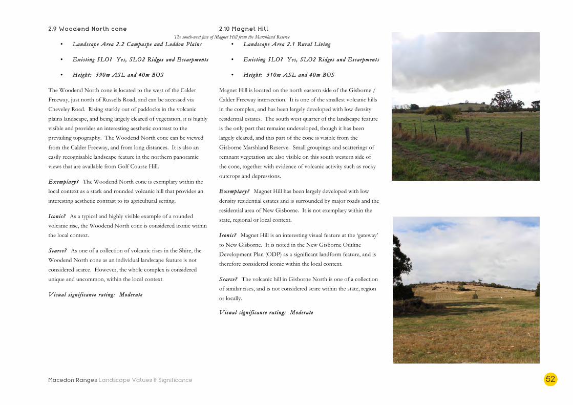
Macedon Ranges Landscape Values & Significance 52
2.9 Woodend North cone
• Landscape Area 2.2 Campaspe and Loddon Pla ins
• Exist ing SLO? Yes , SLO2 Ridges and Escarpments
• Height : 590m ASL and 40m BOS
The Woodend North cone is located to the west of the Calder
Freeway, just north of Russells Road, and can be accessed via
Cheveley Road. Rising starkly out of paddocks in the volcanic
plains landscape, and being largely cleared of vegetation, it is highly
visible and provides an interesting aesthetic contrast to the
prevailing topography. The Woodend North cone can be viewed
from the Calder Freeway, and from long distances. It is also an
easily recognisable landscape feature in the northern panoramic
views that are available from Golf Course Hill.
Exemplary? The Woodend North cone is exemplary within the
local context as a stark and rounded volcanic hill that provides an
interesting aesthetic contrast to its agricultural setting.
Iconi c? As a typical and highly visible example of a rounded
volcanic rise, the Woodend North cone is considered iconic within
the local context.
Scarce? As one of a collection of volcanic rises in the Shire, the
Woodend North cone as an individual landscape feature is not
considered scarce. However, the whole complex is considered
unique and uncommon, within the local context.
Visual s i gn i f i cance ra t ing : Moderate
2.10 Magnet Hill
• Landscape Area 2.1 Rural Liv ing
• Exist ing SLO? Yes , SLO2 Ridges and Escarpments
• Height : 510m ASL and 40m BOS
Magnet Hill is located on the north eastern side of the Gisborne /
Calder Freeway intersection. It is one of the smallest volcanic hills
in the complex, and has been largely developed with low density
residential estates. The south west quarter of the landscape feature
is the only part that remains undeveloped, though it has been
largely cleared, and this part of the cone is visible from the
Gisborne Marshland Reserve. Small groupings and scatterings of
remnant vegetation are also visible on this south western side of
the cone, together with evidence of volcanic activity such as rocky
outcrops and depressions.
Exemplary? Magnet Hill has been largely developed with low
density residential estates and is surrounded by major roads and the
residential area of New Gisborne. It is not exemplary within the
state, regional or local context.
Iconi c? Magnet Hill is an interesting visual feature at the ‘gateway’
to New Gisborne. It is noted in the New Gisborne Outline
Development Plan (ODP) as a significant landform feature, and is
therefore considered iconic within the local context.
Scarce? The volcanic hill in Gisborne North is one of a collection
of similar rises, and is not considered scare within the state, region
or locally.
Visual s i gn i f i cance ra t ing : Moderate
Woodend North cone within its context of paddocks and isolated Eucalypts
The south-west face of Magnet Hill from the Marshland Reserve
Macedon Ranges Landscape Values & Significance 53
Other landscape values
Cultural heritage values
• The volcanic cones and rises are located on the tribal
lands of the three Aboriginal groups that are the
Traditional Owners of the Macedon Ranges Shire
landscapes – the Wurundjeri, Taungurung and Dja Dja
Wurrung.
• Mt Aitken is named after John Aitken, one of the first
European pastoralists in the area. Source: Victorian
Heritage Database
• Mt Aitken features in a painting by George Alexander
Gilbert (c. 1848) ‘View from Mt Aitken looking towards
the Dandenong Ranges.’ Source: State Library of Victoria
Environmental and scientific values
• The Jim Jim is a notable eruption point and the largest
trachyte dome in the region. It formed as a result of an
eruption of viscous anothoclase trachyte lava, which
cooled and is an excellent example of the New Volcanics
period.
• Mount Gisborne Reserve is a 12.7 hectare Scoria Cone
Woodland, which is listed as an endangered EVC within
the Victorian Volcanic Plains Bioregion (DSE 2012). The
vegetation community is rare and localised, being
restricted to the Mt Gisborne area (Oates and Taranto
2001). Source: Environmental Management Plan – Mount
Gisborne Reserve, Gisborne (2013)
• One flora species of national significance has been
recorded at the Mount Gisborne Reserve – the Matted
Flax-lily Dianella amoena, which is listed as endangered
under the Commonwealth Environment Protection and
Biodiversity Conservation Act (1999), and threatened under
the State Flora and Fauna Guarantee Act 1988.
• Mount Aitken is one of the best examples of this type of
eroded volcano. It shows a stage in volcanic landform
development that is not widely represented with erosion
of a summit lava flow from a scoria cone. Source:
Victorian Resources Online, Agriculture Victoria
• The Mt Gisborne volcano has a longer and more
complex lava eruption sequence than any other Newer
Volcanics eruption point. Three lava types are recognised
at the eruption point and none of these occur together at
any other eruption point in the state. It is an important
site for petrological studies of eruption sequences.
Source: Victorian Resources Online, Agriculture Victoria
• Mt Bullengarook is regionally significant for its geology
and geomorphological processes, being a clear example
of erupted materials overlying bedrock. Source: Victorian
Resources Online, Agriculture Victoria
Overall significance level
A number o f the Macedon vo l cani c cones and r i s e s are o f
r eg ional s i gn i f i cance as indiv idual landscape f ea tures . These
are :
• The J im J im
• Mt Bul l engarook
• Mt Gisborne
• Mt Aitken
• Golf Course Hil l
The remaining Macedon vo l cani c cones and r i s e s are o f lo ca l
s i gn i f i cance .
As a group or complex o f vo l cani c cones and r i s e s , the co l l e c t ion i s o f r eg ional s i gn i f i cance .
Macedon Ranges Landscape Values & Significance 54
Conclusion: Landscapes of significance
State significant landscapes
1. Macedon Ranges and Hanging Rock
2. Lerderderg Fores t
Regionally significant landscapes
1. Wombat Fores t
2 . Cobaw Ranges
3 . McHarg Ranges and grani t i c up lands
4 . Mt Wil l iam Ridge and Deep Creek gu l ly
5 . Volcanic cones and r i s e s (when cons idered as a
complex, or grouping) , inc luding the fo l lowing
indiv idual f ea tures :
• The J im J im
• Mt Bul l engarook
• Mt Gisborne
• Mt Aitken
• Golf Course Hil l
Locally significant landscapes
1. The fo l lowing cones and r i s e s (when cons idered as
ind iv idual f ea tures ) :
• Litt l e Bul l engarook
• Melbourne Hil l , Lance f i e ld
• Rochford Road cone , Lance f i e ld
• Joyces Road cone , Romsey
• Woodend North cone
• Magnet Hil l

Macedon Ranges Landscape Values & Significance 55
Part 3: Views of Significance

Macedon Ranges Landscape Values & Significance 56
Defining significant views
Views occur over distance and through view planes, and generally
comprise a foreground, middle ground and background. The
qualities and components of these view planes help to define what
is significant about a view, and changes within them may alter the
qualities and characteristics of a view. Views are sensitive to
changes within the landscape and a viewer’s experience of a view is
also affected by weather variations that contribute to the changing
moods of landscapes and skyscapes.
Viewing distance is important in determining how change is
perceived within a landscape. However, defining view planes in
terms of distances is difficult, as they are also experienced
differently, according to the character of the viewed landscape i.e.
the foreground of a view may terminate at a particular landform, as
opposed to being defined by a distance in metres. Generally
speaking however, the following view plane distances have been
applied to this study and are reflected in the viewshed mapping.
These distances are based on those that were defined (with
reference to other sources) in the South West Victoria Landscape
Assessment Study.
Immediate foreground
This zone takes in the immediate environment of the viewer, and
extends to approximately 800 metres.
Foreground
This zone begins at the viewer (and includes the immediate
foreground), and extends to approximately 1.6km of the observer.
Generally, the detail of the landscape is more pronounced within
this view plane.
Middle ground
The middle ground of a view occurs within 1.6km to 6km, and
alterations within this zone are less distinctive.
Background
This view plane extends from 6km to infinity. Shape may remain
evident beyond 16km, but beyond that distance alterations in the
landscape become obscure.
The viewshed maps have been prepared using Mapinfo Engage
software. The maps depict the actual extents of a 360 degree view
as experienced from a particular viewing location. In some
instances, the view may appear to be infinite, while others may
terminate at a large landscape feature on the horizon. Viewsheds
have been determined purely on topographical data. They do not
take into account any built form or vegetation that may obscure the
view.
Viewing locations
There are many locations within the Macedon Ranges Shire from
which spectacular views are available, including well-known,
elevated lookout points at Hanging Rock and Camels Hump.
Viewing locations throughout the study area have various levels of
accessibility, promotion and visitation. For the purposes of this
study, viewing locations have been chosen because they feature a
view of a regionally or state significant landscape, and they meet a
minimum of three of the following selection considerations:
• The viewing location is a designated lookout point, with
or without interpretive information.
• The viewing location is easily accessible, preferably by
vehicle.
• The viewing location is well known (locally, regionally
and/or at a state level).
• The viewing location is promoted through tourism
information.
• The viewing location is situated on public land.
The views available from locations that satisfy the above selection
considerations have been assessed against the criteria explained in
the following section, in order to determine and justify their level
of significance.

Macedon Ranges Landscape Values & Significance 57
Views significance criteria
Composition: structure
In relation to compositional structure, views have been assessed
against the following criterion in order to determine a level of
significance:
The v i ew has outs tanding compos i t ional qual i t i e s , whether a
c lass i c v i s ta , or a sweep ing panorama. The v i ew i s ba lanced ,
bo th hor izonta l ly and ver t i ca l ly ; a p i c ture pos t card v i ew. The
fo ca l po int o f the v i ew may be c entr ed , and e l ements in the
for eground, middle ground and background, equal ly we ighted .
The v i ew may be f ramed by landscape e l ements to the v i ewer ’ s
l e f t and r ight .
Composition: qualities
In relation to compositional qualities, views have been assessed
against the following criterion:
The v i ew i s compe l l ing or insp ir ing for i t s aes the t i c qual i t i e s ,
in c lud ing a landscape f ea ture ( that may be the fo ca l po int o f the
v i ew) , or a co l l e c t ion o f landscape f ea tures ; edges or contras t s ;
and o ther compos i t ional e l ements such as co lour and t exture .
Other cultural values
Consideration of other cultural values, that may contribute or
support the overall significance of a view, has also been
undertaken.
Social values
The following criterion was used to determine social value:
The v i ew i s wide ly promoted , we l l known and popular wi th
tour i s t s . I t i s a v i ew o f note that i s avai lab le f rom a publ i c l y
ac c e s s ib l e lo ca t ion .
Cultural heritage, environmental /scientific, &
other values
Other cultural values have been taken into account where relevant:
The v i ew or v i ewing lo ca t ion i s important for i t s o ther cu l tura l
va lues , in c luding her i tage , env ironmenta l , s c i en t i f i c or o ther
va lues .

Macedon Ranges Landscape Values & Significance 58
Levels of significance
In order to determine a level of significance for each view
component and value, and ultimately each view, the following
rating considerations have been applied:
Exemplary
How representat ive or i l lus t ra t ive i s th i s v i ew? Is i t the ‘bes t ’
o f i t s t ype? Is i t exemplary wi th in the lo ca l , r eg ional or s ta t e
context?
Iconic
Is the v i ew ins tant ly r e cogn izable? I s i t symbol i c for i t s v i sua l
qual i t i e s? Has i t been represented in ar t , photography or
l i t e ra ture e t c .? I s i t i con i c wi th in the lo ca l , r eg ional or s ta t e
context?
Scarce
How uncommon or rare i s the v i ew? Is the v i ew a ‘one o f f ’ that
i s not ava i lab le nearby or e l s ewhere in the s tudy area? Is i t
s car ce wi th in the lo ca l , r eg ional or s ta t e context?
Significance levels
Levels of significance were attributed to each view component and
value, and an overall significance level for the view was determined.
The significance levels are the same as those attributed to
landscapes:
• Moderate = local significance
• High = regional significance
• Exceptional = state significance or higher
As with the determination of landscape significance, if a view rated
‘high’ (for example) in one or more of the view components, that
level was the overall significance rating attributed to the view.
Levels of significance were attributed to the other cultural values of
the view, based on the stated level of significance in the secondary
source, or based on the source itself.
Again, as with landscape significance, a view has not been classified
as significant for its cultural heritage, environmental, scientific,
social or other values alone. In order for a view to be deemed
significant, it must substantially meet the visual composition
(structure and qualities) criteria.
A map depicting the significant views that are fully assessed in this
report is included on the following page.
A summary list of significant views (and their determined
significance levels) is provided at the conclusion of this section of
the report.

Macedon Ranges Landscape Values & Significance 59
Views of significance
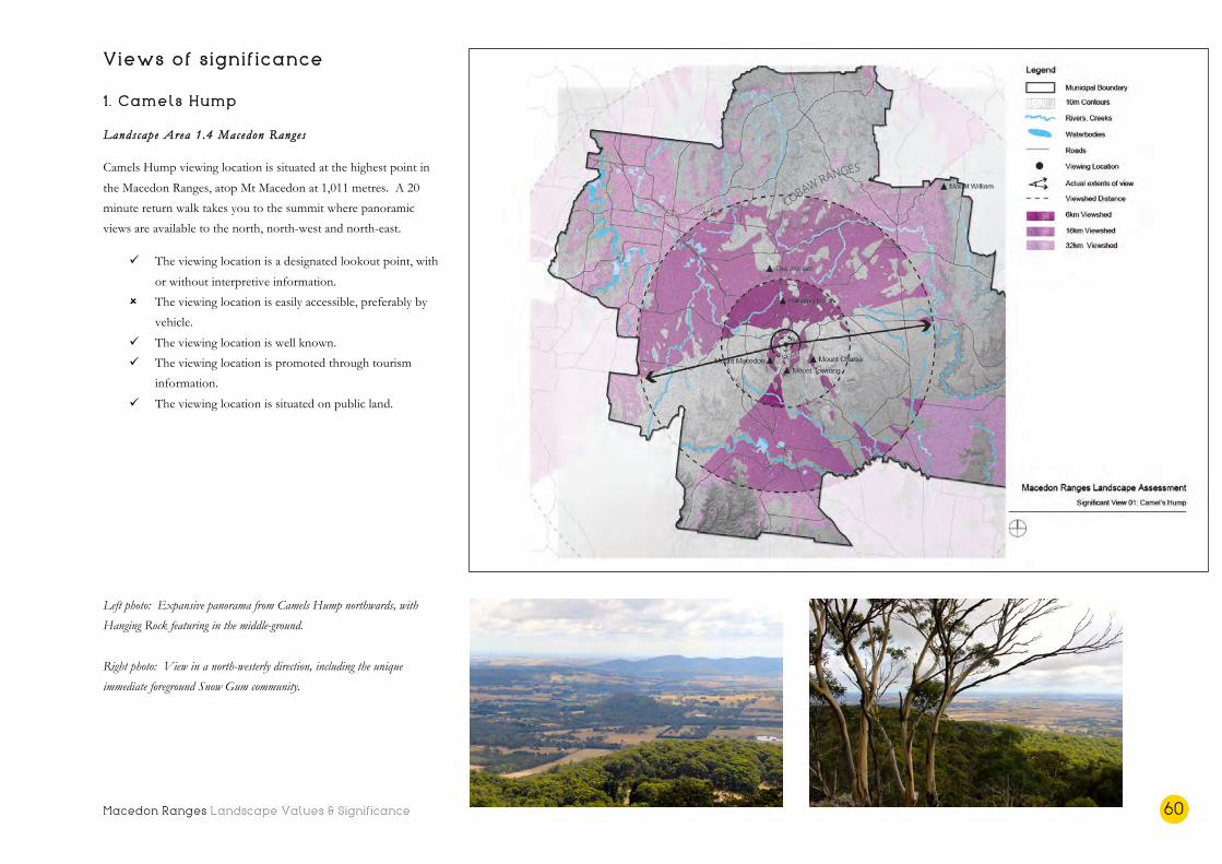
Macedon Ranges Landscape Values & Significance 60
Views of significance 1 . Camels Hump
Landscape Area 1.4 Macedon Ranges
Camels Hump viewing location is situated at the highest point in
the Macedon Ranges, atop Mt Macedon at 1,011 metres. A 20
minute return walk takes you to the summit where panoramic
views are available to the north, north-west and north-east.
ü The viewing location is a designated lookout point, with
or without interpretive information.
û The viewing location is easily accessible, preferably by
vehicle.
ü The viewing location is well known.
ü The viewing location is promoted through tourism
information.
ü The viewing location is situated on public land.
Left photo: Expansive panorama from Camels Hump northwards, with
Hanging Rock featuring in the middle-ground.
Right photo: View in a north-westerly direction, including the unique
immediate foreground Snow Gum community.
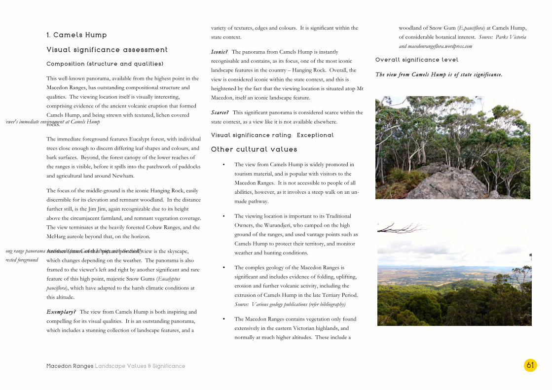
Macedon Ranges Landscape Values & Significance 61
1 . Camels Hump
Visual significance assessment
Composition (structure and qualities)
This well-known panorama, available from the highest point in the
Macedon Ranges, has outstanding compositional structure and
qualities. The viewing location itself is visually interesting,
comprising evidence of the ancient volcanic eruption that formed
Camels Hump, and being strewn with textured, lichen covered
rocks.
The immediate foreground features Eucalypt forest, with individual
trees close enough to discern differing leaf shapes and colours, and
bark surfaces. Beyond, the forest canopy of the lower reaches of
the ranges is visible, before it spills into the patchwork of paddocks
and agricultural land around Newham.
The focus of the middle-ground is the iconic Hanging Rock, easily
discernible for its elevation and remnant woodland. In the distance
further still, is the Jim Jim, again recognizable due to its height
above the circumjacent farmland, and remnant vegetation coverage.
The view terminates at the heavily forested Cobaw Ranges, and the
McHarg aureole beyond that, on the horizon.
Another feature of this ‘picture postcard’ view is the skyscape,
which changes depending on the weather. The panorama is also
framed to the viewer’s left and right by another significant and rare
feature of this high point, majestic Snow Gums (Eucalyptus
pauciflora), which have adapted to the harsh climatic conditions at
this altitude.
Exemplary? The view from Camels Hump is both inspiring and
compelling for its visual qualities. It is an outstanding panorama,
which includes a stunning collection of landscape features, and a
variety of textures, edges and colours. It is significant within the
state context.
Iconi c? The panorama from Camels Hump is instantly
recognisable and contains, as its focus, one of the most iconic
landscape features in the country – Hanging Rock. Overall, the
view is considered iconic within the state context, and this is
heightened by the fact that the viewing location is situated atop Mt
Macedon, itself an iconic landscape feature.
Scarce? This significant panorama is considered scarce within the
state context, as a view like it is not available elsewhere.
Visual significance rating: Exceptional
Other cultural values
• The view from Camels Hump is widely promoted in
tourism material, and is popular with visitors to the
Macedon Ranges. It is not accessible to people of all
abilities, however, as it involves a steep walk on an un-
made pathway.
• The viewing location is important to its Traditional
Owners, the Wurundjeri, who camped on the high
ground of the ranges, and used vantage points such as
Camels Hump to protect their territory, and monitor
weather and hunting conditions.
• The complex geology of the Macedon Ranges is
significant and includes evidence of folding, uplifting,
erosion and further volcanic activity, including the
extrusion of Camels Hump in the late Tertiary Period.
Source: Various geology publications (refer bibliography)
• The Macedon Ranges contains vegetation only found
extensively in the eastern Victorian highlands, and
normally at much higher altitudes. These include a
woodland of Snow Gum (E.pauciflora) at Camels Hump,
of considerable botanical interest. Source: Parks Victoria
and macedonrangeflora.wordpress.com
Overall significance level
The v i ew f rom Camels Hump is o f s ta t e s i gn i f i cance .
Viewer's immediate environment at Camels Hump
Long range panorama northwards from Camels Hump, with the thickly
forested foreground

Macedon Ranges Landscape Values & Significance 62
Views of significance 2. Major Mitchell Lookout
Landscape Area 1.4 Macedon Ranges
The Major Mitchell Lookout is located on the eastern side of the
pedestrian pathway to the Mt Macedon Memorial Cross, and long
range out-views are available to the west. The area is accessible by
vehicle, and the lookout point is a five minute walk from the car
park.
ü The viewing location is a designated lookout point, with
or without interpretive information.
ü The viewing location is easily accessible, preferably by
vehicle.
ü The viewing location is well known.
ü The viewing location is promoted through tourism
information.
ü The viewing location is situated on public land.
Left photo: Panoramic out-view to the west with contrasts in vegetation types,
and the Macedon plantation, evident from this elevation
Right photo: The panoramic out-views stretch to the north west from the Major
Mitchell Lookout

Macedon Ranges Landscape Values & Significance 63
2. Major Mitchell Lookout
Visual significance assessment
Composition (structure and qualities)
The panoramic out-views from this well known lookout point are
open and expansive. The immediate foreground is grassy and
strewn with volcanic rocks, before a view of intact Eucalypt
woodland forest.
Beyond the native vegetation is a sweeping view of gently
undulating hills, appearing as a medley of colour and textures, and
including swathes of plantation in various stages of development,
from mature and dark green, to felled.
The background of the view is the heavily vegetated northern
reaches of the Wombat Forest, before it terminates at the horizon
under big skies.
Exemplary? The panoramic view from the Major Mitchell
lookout is compelling for the vast distances it spans, and for the
visually interesting mix of scenery across a predominantly working
landscape. It is considered an exemplar within the regional
context.
I con i c? The view is iconic within the regional context, and this
rating is reinforced by the association of the viewing location with
Major Thomas Mitchell, the first European to climb Mt Macedon.
Scarce? Similar views are available from the Top of the Range
Tearooms nearby, however the Major Mitchell Lookout is uniquely
located at a high elevation of around 1,000 metres, affording
elevated views of the surrounding landscape. As such it is
considered scarce within the regional context.
Visual significance rating: High
Other cultural values
• The Major Mitchell Lookout point is widely known and
promoted. It is popular with tourists to the area and is
very accessible, involving a very short, paved pathway to
the lookout location.
• The high points of Mt Macedon and the entire
mountainous landscape is significant to its Traditional
Owners, the Wurundjeri, who camped on the high
ground of the ranges. Source: Parks Victoria, via the Central
Victoria Landscape Assessment Study (2015)
• The lookout point is named after Major Thomas Mitchell,
the first European to climb the mountain in 1836.
Mitchell used Mt Macedon as a directional landmark and
named the peak as reference to Philip II of ancient
Macedonia. Source: Parks Victoria
• This viewing location was highlighted by the community
during consultation for its panoramic views.
Overall significance level
The v i ew f rom the Major Mitche l l Lookout i s o f r eg ional
s i gn i f i cance .
Middle-ground of the panoramic out-view from Major Mitchell Lookout
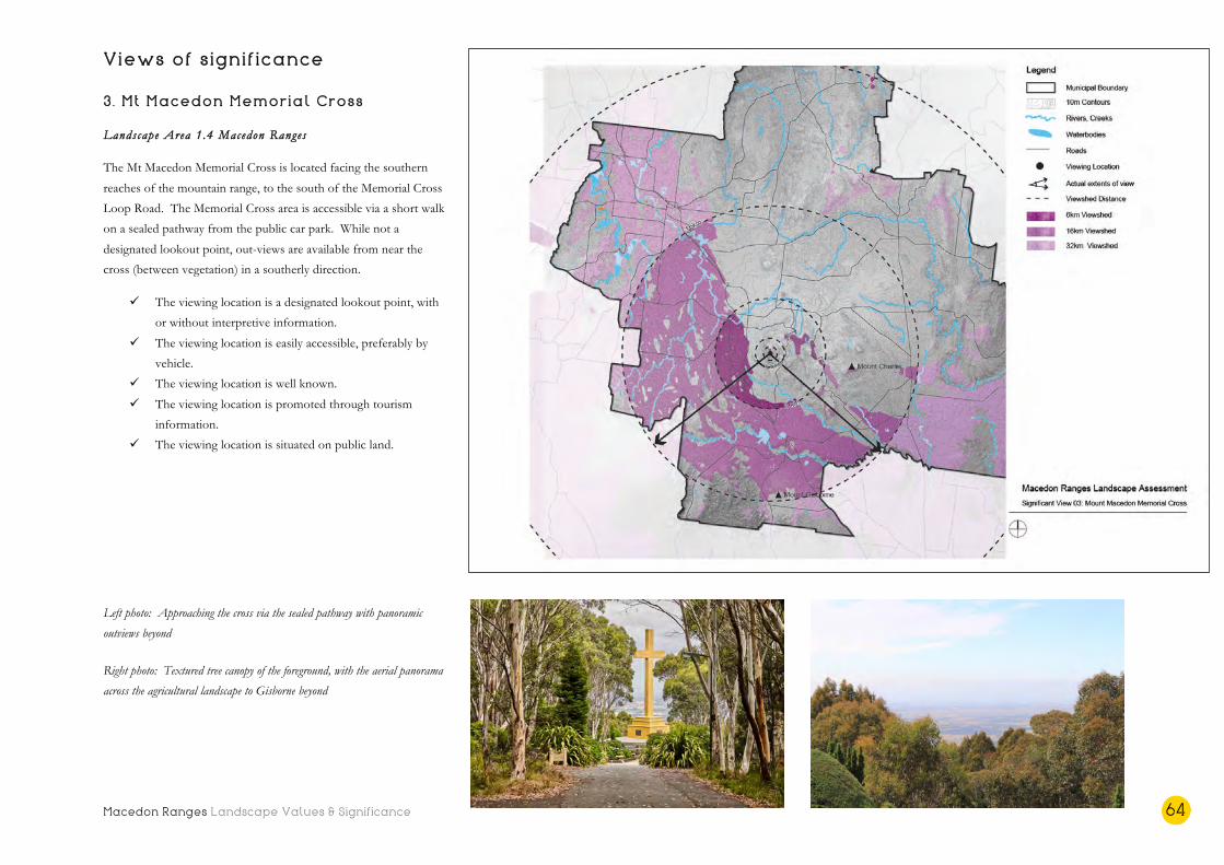
Macedon Ranges Landscape Values & Significance 64
Views of significance 3. Mt Macedon Memorial Cross
Landscape Area 1.4 Macedon Ranges
The Mt Macedon Memorial Cross is located facing the southern
reaches of the mountain range, to the south of the Memorial Cross
Loop Road. The Memorial Cross area is accessible via a short walk
on a sealed pathway from the public car park. While not a
designated lookout point, out-views are available from near the
cross (between vegetation) in a southerly direction.
ü The viewing location is a designated lookout point, with
or without interpretive information.
ü The viewing location is easily accessible, preferably by
vehicle.
ü The viewing location is well known.
ü The viewing location is promoted through tourism
information.
ü The viewing location is situated on public land.
Left photo: Approaching the cross via the sealed pathway with panoramic
outviews beyond Right photo: Textured tree canopy of the foreground, with the aerial panorama
across the agricultural landscape to Gisborne beyond

Macedon Ranges Landscape Values & Significance 65
3. Mt Macedon Memorial Cross
Visual significance assessment
Composition (structure and qualities)
The viewing experience at this location begins with ascending the
pedestrian path towards Memorial Cross. After rounding a bend in
the pathway, the golden monolithic cross appears in view, framed
by exotic vegetation to the viewer’s left and right. The cross grows
in stature on approach and its formal curtilage of trimmed conifers
and other exotic species becomes evident.
Beyond the fenced setting of the Memorial Cross are the heavily
forested slopes of the southern side of the range, which partially
block outviews, but provide a textural and dense foreground view.
Between gaps in the vegetation, a long-range vista southwards can
be glimpsed, over the agricultural plains north of Gisborne to the
township itself. On a clear day, Mt Gisborne is visible on the
horizon where the vista terminates.
Exemplary? This vista, which is glimpsed between a dense
foreground of forest, is exemplary for its composition and expanse,
within the regional context.
Iconi c? This vista across the volcanic plains towards Gisborne is
considered iconic within the regional context, and this is elevated
by the location of the viewing point at the culturally and socially
significant Memorial Cross.
Scarce? The viewing experience from near the Mt Macedon
Memorial Cross is considered uncommon and rare within the
regional context.
Visual significance rating: High
Other cultural values
• While not promoted as a lookout point, the existence of
the Memorial Cross makes this a popular destination,
and by virtue of its elevation, a popular viewing location.
It is also relatively accessible, requiring viewers to
navigate a short, paved pathway.
• The ‘Macedon Cross’ is listed on the Victorian Heritage
Register (H1027) but refers to the original Cameron
Memorial Cross, which was dedicated in 1935, and has
since been replaced. Source: Victorian Heritage Register
(VHR)
• The original Memorial Cross was a gift to the people of
Victoria from William Cameron, of Cameron Lodge, Mt
Macedon, to commemorate the Australian veterans of
the First World War. The original Memorial Cross
weathered and deteriorated structurally, and was replaced
by the current pre-case concrete cross 1995. Source:
memorial plaque on site
• This viewing location was highlighted by the community
during consultation for its views and social significance.
Overall significance level
The v i ew f rom the Mt Macedon Memoria l Cross i s o f r eg ional
s i gn i f i cance .
Exotics and native forest vegetation line the pathway to the memorial cross
Immediate foreground, adjacent to the viewer, looking southwards

Macedon Ranges Landscape Values & Significance 66
Views of significance 4. Mt Towrong
Landscape Area 1.4 Macedon Ranges
The summit of Mt Towrong is quite remote and a good level of
fitness is required. It is part of the Macedon Ranges Walking Trail
loop, but can be accessed via a steep ascent from Anzac Road or
from the walking trail branching off Hemphill’s Track. While not a
designated lookout point, it is well known to walkers for its views
over the Mount Macedon township and south-west across the
valley towards Gisborne and the Rosslyn Reservoir. The Memorial
Cross can also be seen from this vantage point.
ü The viewing location is a designated lookout point, with
or without interpretive information.
û The viewing location is easily accessible, preferably by
vehicle.
ü The viewing location is well known.
ü The viewing location is promoted through tourism
material.
ü The viewing location is situated on public land.
Left photo: Tall timbers envelop the viewer on the walking track to the Mt
Towrong summit
Right photo: Once elevated on the south western side of the mountain, the view
takes in Mt Macedon itself and stretches all the way to the Wombat and
Lerderderg forest areas
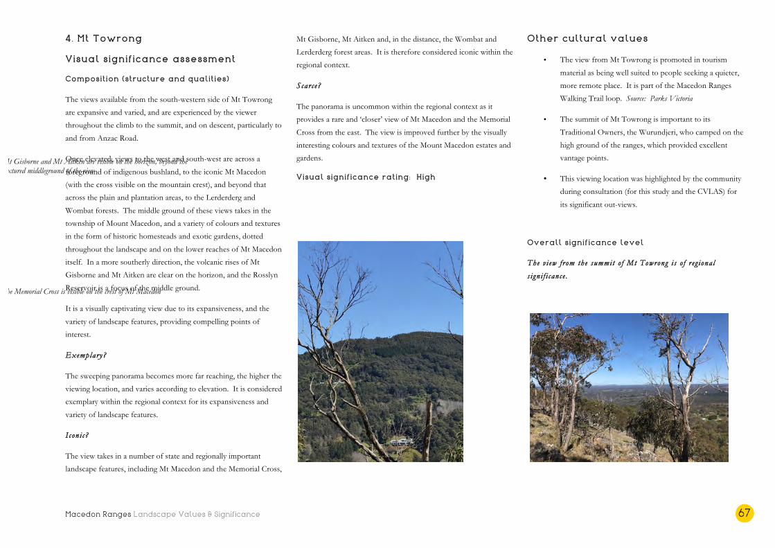
Macedon Ranges Landscape Values & Significance 67
4. Mt Towrong
Visual significance assessment
Composition (structure and qualities)
The views available from the south-western side of Mt Towrong
are expansive and varied, and are experienced by the viewer
throughout the climb to the summit, and on descent, particularly to
and from Anzac Road.
Once elevated, views to the west and south-west are across a
foreground of indigenous bushland, to the iconic Mt Macedon
(with the cross visible on the mountain crest), and beyond that
across the plain and plantation areas, to the Lerderderg and
Wombat forests. The middle ground of these views takes in the
township of Mount Macedon, and a variety of colours and textures
in the form of historic homesteads and exotic gardens, dotted
throughout the landscape and on the lower reaches of Mt Macedon
itself. In a more southerly direction, the volcanic rises of Mt
Gisborne and Mt Aitken are clear on the horizon, and the Rosslyn
Reservoir is a focus of the middle ground.
It is a visually captivating view due to its expansiveness, and the
variety of landscape features, providing compelling points of
interest.
Exemplary?
The sweeping panorama becomes more far reaching, the higher the
viewing location, and varies according to elevation. It is considered
exemplary within the regional context for its expansiveness and
variety of landscape features.
Iconi c?
The view takes in a number of state and regionally important
landscape features, including Mt Macedon and the Memorial Cross,
Mt Gisborne, Mt Aitken and, in the distance, the Wombat and
Lerderderg forest areas. It is therefore considered iconic within the
regional context.
Scarce?
The panorama is uncommon within the regional context as it
provides a rare and ‘closer’ view of Mt Macedon and the Memorial
Cross from the east. The view is improved further by the visually
interesting colours and textures of the Mount Macedon estates and
gardens.
Visual significance rating: High
Other cultural values
• The view from Mt Towrong is promoted in tourism
material as being well suited to people seeking a quieter,
more remote place. It is part of the Macedon Ranges
Walking Trail loop. Source: Parks Victoria
• The summit of Mt Towrong is important to its
Traditional Owners, the Wurundjeri, who camped on the
high ground of the ranges, which provided excellent
vantage points.
• This viewing location was highlighted by the community
during consultation (for this study and the CVLAS) for
its significant out-views.
Overall significance level
The v i ew f rom the summit o f Mt Towrong i s o f r eg ional
s i gn i f i cance .
The Memorial Cross is visible on the crest of Mt Macedon
Mt Gisborne and Mt Aitken are visible on the horizon, beyond the textured middleground of the view

Macedon Ranges Landscape Values & Significance 68
Views of significance 5. Summit, Hanging Rock
Landscape Area 1.5 Newham Rises
The summit of Hanging Rock is accessed via a walking track,
which weaves up to the pinnacle, from which panoramic out-views
are available. A base walking track that circumnavigates the rock
also provides up-close views of the landscape feature, its geology
and vegetation.
ü The viewing location is a designated lookout point, with
or without interpretive information.
û The viewing location is easily accessible, preferably by
vehicle.
ü The viewing location is well known.
ü The viewing location is promoted in tourism
information.
ü The viewing location is situated on public land.
Left photo: View from Hanging Rock summit towards the north-west, with
the Jim Jim visible in the distant middle-ground
Right photo: North-westerly panorama from Hanging Rock, taking in the
dynamic skyscape
Macedon Ranges Landscape Values & Significance 69
5. Summit, Hanging Rock
Visual significance assessment
Composition (structure and qualities)
The ascent to the Hanging Rock summit is a fascinating walk that
allows the viewer to experience the geology of the rock, and
formations such as the Black Hole of Calcutta, the Eagle, the
Chapel and Lover’s Leap, from close proximity.
The high points of Hanging Rock provide stunning panoramic
views – northerly towards the Jim Jim and the Cobaw Ranges,
easterly over farmland towards the distant Mt William Ranges, and
to the majestic Macedon Ranges in the south.
The immediate foreground comprises craggy volcanic rocks and
lichen covered pinnacles, before a view over the adjacent woodland
canopy. The middle-ground, in all directions, is made up of gently
undulating farmland, including cleared paddocks in a colour
spectrum of greens and golds (depending on the season), rows of
shelterbelts, and remnant stands of Eucalypts. The volcanic rise of
the Jim Jim features in the distant middle-view to the north-west.
The spectacular and expansive panoramas terminate at heavily
forested mountain ranges, including the Cobaw to the north and
the Macedon Ranges, at a closer distance, southwards. The less
heavily treed Mt William ridge and its foothills are visible at the
termination of the view to the east.
Again, due to the relatively flat middle and foreground, big skies
dominate the upper half of these panoramas. Due to the lower
elevation of the viewing location, these views differ from Camels
Hump in that the detail of the agricultural middle-ground is more
discernable.
Exemplary? The outviews from this iconic location have
outstanding composition qualities, and are best described as
sweeping panoramas. They are structurally balanced, sometimes
with volcanic pinnacles framing the immediate foreground, and
include a diverse collection of landscape features, colours and
textures. All of these qualities combine into making these views
exemplary within the state context.
I con i c? The panoramas available from the Hanging Rock summit
are also iconic within the state context. The views and the
landscape features within the views are instantly recognizable, and
have been depicted in art and literature, largely due to their
association with Hanging Rock, a national icon.
Scarce? The sweeping panoramas from Hanging Rock are not
available elsewhere in the state, and are considered uncommon and
rare within Victoria.
Visual significance rating: Exceptional
Other cultural values
• The summit walk and view from Hanging Rock is widely
promoted in tourism information, is well known across
the state and nation, and is very popular with tourists,
both local and international. It is not, however,
accessible to people of all abilities.
• Hanging Rock is located at the intersection of the tribal
lands of the Wurundjeri, Taungurung and Dja Dja
Wurrung, and has always been a sacred place for its
Traditional Owners. Source: Registered Aboriginal Parties
(RAP) area maps
• Hanging Rock and the surrounding reserve is listed on
the Victorian Heritage Register (H2339). Source: VHR
Hanging Rock is also listed on the National Trust
Heritage Register (L10133). Source: National Trust
• The distinctive geological formation of Hanging Rock
has attracted visitors since the 1860s for picnics,
entertainment and recreation, with tourists climbing the
rock to experience the spectacular out-views since that
time. Source: VHR
• Hanging Rock is an unusual volcanic eruption point for
Victoria both in terms of its form and rock composition.
Source: Geological Society of Australia, Victorian Division
• Hanging Rock’s mysterious associations reached
international audiences through the classic 1967 Joan
Lindsay novel and Peter Weir’s film ‘Picnic at Hanging
Rock’.
Overall significance level
The v i ews f rom the Hanging Rock summit are o f s ta t e
s i gn i f i cance .

Macedon Ranges Landscape Values & Significance 70
Views of significance 6. Gisborne Marshland Reserve
Landscape Area 2.1 Rural Liv ing
The Gisborne Marshland Reserve is one of the few surviving
wetland environments in the Shire, and is a popular walking and
bird watching location, primarily for locals. The reserve is
accessible by vehicle, and the edge of the wetland is immediately
accessible from there, via a gate.
û The viewing location is a designated lookout point, with
or without interpretive information.
ü The viewing location is easily accessible, preferably by
vehicle.
ü The viewing location is well known (locally).
ü The viewing location is promoted in tourism
information.
ü The viewing location is situated on public land.
Left photo: View northwards from the Marshland Reserve, with Mt Macedon
terminating the view
Right photo: Views westwards from the edge of the waterbody within the
reserve

Macedon Ranges Landscape Values & Significance 71
6. Gisborne Marshland Reserve
Visual significance assessment
Composition (structure and qualities)
This locally cherished wetland and viewing location provides an
open view towards the majestic, vegetated outline of the Macedon
Ranges, which varies depending on the viewer’s location within the
reserve.
In all locations, the immediate foreground is of grasslands at the
edge of the wetland lake. The element of water, also in the
foreground of most views, adds to the scenic beauty of the
location.
The middle-ground of the view northwards is dominated by low
grassland vegetation. Remnant woodland is visible at the far edge
of the grasslands landscape, and the view terminates at the dark and
distant form of the Macedon Ranges.
Exemplary? The view of the Macedon Ranges silhouette from
the Gisborne Marshland Reserve is considered exemplary within
the local context. The openness and existence of water
distinguishes it from other views available in the Shire, however,
the uniformity of the foreground and middle-ground, and the un-
framed composition, prevent it from being elevated to an exemplar
within the region.
I con i c? The termination of the view at the iconic form of the
Macedon Ranges, and the foreground of the wetland lake, makes
this view symbolic within the local context.
Scarce? This view is uncommon and rare within the local context.
A view of Mt Macedon from a wetlands location is not available
elsewhere in the Shire, however more compelling views (made so
by the existence of a collection of landscape features and
heightened visual variety) are available regionally.
Visual significance rating: Moderate
Other cultural values
• While not a designated lookout point, the reserve is a
popular destination for locals and is promoted on the
MRSC website. It is also relatively accessible compared
to other viewing locations that require steep walks or
climbs on un-made surfaces.
• The Gisborne Marshland is one of the few remaining
wetland environments in the Shire on public land. This
reserve supports a range of wetland fauna including a
variety of frogs, skinks, snakes and water birds. Source:
MRSC website
Overall significance level
The v i ew f rom the Gisborne Marsh land Reserve i s o f lo ca l
s i gn i f i cance .
View of the Macedon Ranges from the reserve, across the grassland
landscape, with remnant vegetation in the middle-ground
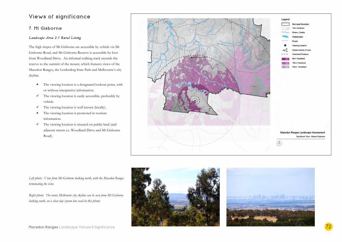
Macedon Ranges Landscape Values & Significance 72
Views of significance 7. Mt Gisborne
Landscape Area 2.1 Rural Liv ing
The high slopes of Mt Gisborne are accessible by vehicle via Mt
Gisborne Road, and Mt Gisborne Reserve is accessible by foot
from Woodland Drive. An informal walking track ascends the
reserve to the summit of the mount, which features views of the
Macedon Ranges, the Lerderderg State Park and Melbourne’s city
skyline.
û The viewing location is a designated lookout point, with
or without interpretive information.
ü The viewing location is easily accessible, preferably by
vehicle.
ü The viewing location is well known (locally).
û The viewing location is promoted in tourism
information.
ü The viewing location is situated on public land (and
adjacent streets i.e. Woodland Drive and Mt Gisborne
Road).
Left photo: View from Mt Gisborne looking north, with the Macedon Ranges
terminating the vista
Right photo: The iconic Melbourne city skyline can be seen from Mt Gisborne
looking south, on a clear day (zoom lens used in this photo)

Macedon Ranges Landscape Values & Significance 73
7. Mt Gisborne
Visual significance assessment
Composition (structure and qualities)
The out-views available from the summit of Mt Gisborne, and the
road encircling the summit are varied, visually interesting, and in
the case of the distant views of Melbourne’s CBD, iconic.
In most instances, the viewing location is set within the open
woodland reserve. Northwards, the fairly contained vista is over
rural living properties interspersed with stands of native vegetation,
and the township of Gisborne. The mix of rooftops, exotic and
native tree canopies makes for a textured and colourful fore and
middle-ground. This view terminates at the imposing and heavily
vegetated Macedon Ranges.
Towards the south, the panoramic view is over the flat to gently
undulating farmland and remnant Eucalypts of the volcanic plain,
towards the distant ‘Manhattan-esque’ Melbourne city skyline. The
form of the CBD buildings is hazy on the horizon, appearing as an
illusion in shades of blue.
Westwards from Mt Gisborne the panorama is over the partially
cleared agricultural plains towards the Pyrete Ranges, which form
part of the Lerderderg State Park. The range is heavily forested
and stands out as a dark curvilinear form at the termination of the
expansive view.
Exemplary? There are a variety of vistas and panoramas available
from Mt Gisborne in all directions, and they are compositionally
balanced and interesting. All of the views feature, or terminate, at a
significant point of interest. The views are considered exemplary
within the regional context.
I con i c? The views from this volcanic rise, with a foreground of
the volcanic plain landscape, are considered symbolic at the
regional level. The view of the Melbourne CBD skyline to the
south is considered particularly iconic and instantly recognizable.
Scarce? Such a variety of views to significant landscape features is
considered uncommon in the regional context.
Visual significance rating: High
Other cultural values
• While not a designated lookout point, the views available
from the summit of Mt Gisborne (and from the road
encircling the summit) are well known locally and are
promoted on the MRSC website.
• The viewing location of Mount Gisborne Reserve is
significant for its 12.7 hectare Scoria Cone Woodland,
which is listed as an endangered EVC within the
Victorian Volcanic Plains Bioregion (DSE 2012).
• The Mt Gisborne viewing location is unique as a volcano
that has a longer and more complex lava eruption
sequence than any other Newer Volcanics eruption
point. It is an important site for petrological studies of
eruption sequences. Source: Victorian Resources Online,
Agriculture Victoria
Overall significance level
The v i ews f rom Mt Gisborne are o f r eg ional s i gn i f i cance .
Looking west across the agricultural plains, and towards the Lerderderg
State Park and Pyrete Ranges
View of Mt Gisborne from the northern entry point to the township
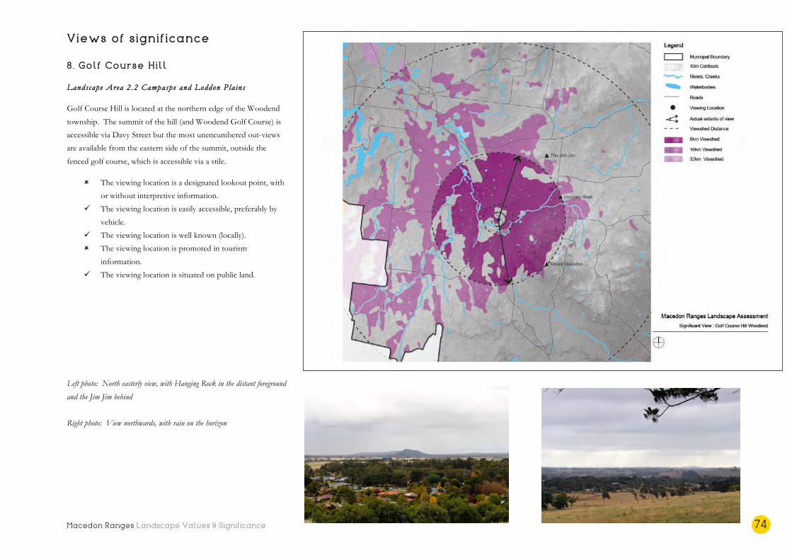
Macedon Ranges Landscape Values & Significance 74
Views of significance 8. Golf Course Hill
Landscape Area 2.2 Campaspe and Loddon Pla ins
Golf Course Hill is located at the northern edge of the Woodend
township. The summit of the hill (and Woodend Golf Course) is
accessible via Davy Street but the most unencumbered out-views
are available from the eastern side of the summit, outside the
fenced golf course, which is accessible via a stile.
û The viewing location is a designated lookout point, with
or without interpretive information.
ü The viewing location is easily accessible, preferably by
vehicle.
ü The viewing location is well known (locally).
û The viewing location is promoted in tourism
information.
ü The viewing location is situated on public land.
Left photo: North easterly view, with Hanging Rock in the distant foreground
and the Jim Jim behind
Right photo: View northwards, with rain on the horizon
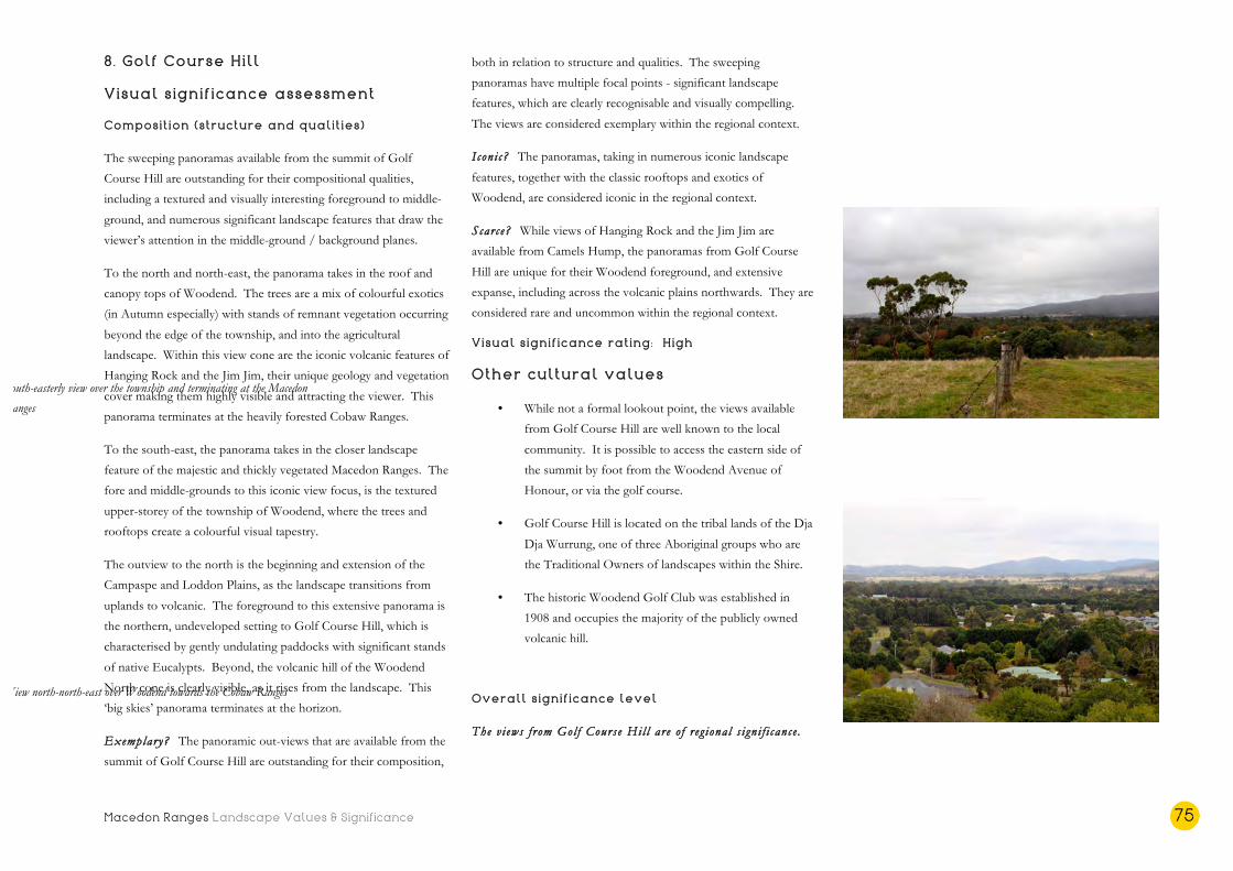
Macedon Ranges Landscape Values & Significance 75
8. Golf Course Hill
Visual significance assessment
Composition (structure and qualities)
The sweeping panoramas available from the summit of Golf
Course Hill are outstanding for their compositional qualities,
including a textured and visually interesting foreground to middle-
ground, and numerous significant landscape features that draw the
viewer’s attention in the middle-ground / background planes.
To the north and north-east, the panorama takes in the roof and
canopy tops of Woodend. The trees are a mix of colourful exotics
(in Autumn especially) with stands of remnant vegetation occurring
beyond the edge of the township, and into the agricultural
landscape. Within this view cone are the iconic volcanic features of
Hanging Rock and the Jim Jim, their unique geology and vegetation
cover making them highly visible and attracting the viewer. This
panorama terminates at the heavily forested Cobaw Ranges.
To the south-east, the panorama takes in the closer landscape
feature of the majestic and thickly vegetated Macedon Ranges. The
fore and middle-grounds to this iconic view focus, is the textured
upper-storey of the township of Woodend, where the trees and
rooftops create a colourful visual tapestry.
The outview to the north is the beginning and extension of the
Campaspe and Loddon Plains, as the landscape transitions from
uplands to volcanic. The foreground to this extensive panorama is
the northern, undeveloped setting to Golf Course Hill, which is
characterised by gently undulating paddocks with significant stands
of native Eucalypts. Beyond, the volcanic hill of the Woodend
North cone is clearly visible, as it rises from the landscape. This
‘big skies’ panorama terminates at the horizon.
Exemplary? The panoramic out-views that are available from the
summit of Golf Course Hill are outstanding for their composition,
both in relation to structure and qualities. The sweeping
panoramas have multiple focal points - significant landscape
features, which are clearly recognisable and visually compelling.
The views are considered exemplary within the regional context.
Iconi c? The panoramas, taking in numerous iconic landscape
features, together with the classic rooftops and exotics of
Woodend, are considered iconic in the regional context.
Scarce? While views of Hanging Rock and the Jim Jim are
available from Camels Hump, the panoramas from Golf Course
Hill are unique for their Woodend foreground, and extensive
expanse, including across the volcanic plains northwards. They are
considered rare and uncommon within the regional context.
Visual significance rating: High
Other cultural values
• While not a formal lookout point, the views available
from Golf Course Hill are well known to the local
community. It is possible to access the eastern side of
the summit by foot from the Woodend Avenue of
Honour, or via the golf course.
• Golf Course Hill is located on the tribal lands of the Dja
Dja Wurrung, one of three Aboriginal groups who are
the Traditional Owners of landscapes within the Shire.
• The historic Woodend Golf Club was established in
1908 and occupies the majority of the publicly owned
volcanic hill.
Overall significance level
The v i ews f rom Gol f Course Hil l are o f r eg ional s i gn i f i cance .
View north-north-east over Woodend towards the Cobaw Ranges
South-easterly view over the township and terminating at the Macedon
Ranges

Macedon Ranges Landscape Values & Significance 76
Views of significance 9 . Mt Aitken
Landscape Area 2.1 Rural Liv ing
Mt Aitken is accessible by vehicle via Berrie Road, with the public
reserve, which stretches to the summit, able to be accessed on foot.
Views are available from this high point in all directions, including
to the Melbourne CBD to the south.
û The viewing location is a designated lookout point, with
or without interpretive information.
ü The viewing location is easily accessible, preferably by
vehicle.
ü The viewing location is well known (locally).
û The viewing location is promoted in tourism
information.
ü The viewing location is situated on public land.
Left photo: View east from Mt Aitken, across the agricultural landscape of
the volcanic plains
Right photo: Distant view of Melbourne city skyline on the horizon, looking
south-east

Macedon Ranges Landscape Values & Significance 77
9 . Mt Aitken
Visual significance assessment
Composition (structure and qualities)
The largely cleared volcanic rise of Mt Aitken provides expansive
out-views from its summit. The viewing location / immediate
foreground to all views is the textured cone itself, which displays
evidence of volcanic activity on its surface.
The far-reaching middle ground of the panoramic out-views in all
directions is across the relatively flat volcanic plains landscape, with
other volcanic cones and rises punctuating the surface periodically.
The largely agricultural landscape comprises a collection of
paddocks, exotic shelterbelts, farm fencing and stands of remnant
vegetation.
The distant background of all views features iconic landscapes on
the horizon, including the Melbourne cityscape to the south, the
Macedon Ranges to the north and the Lerderderg Forest to the
west.
Exemplary? The panoramic out-views from Mt Aitken are open,
expansive and unencumbered. They include an interesting middle-
ground of agricultural farmland and terminate at very distant
landscape features on the horizon. Compared to the panoramic
views that are available from Mt Gisborne and Golf Course Hill,
they are less visually interesting in the foreground and middle-
ground, and are not framed either side of the viewer. The views
are considered exemplary within the local context.
Iconi c? The expansive panoramas available from Mt Aitken are
considered iconic within the local context. While they have been
represented in a well known painting by George Alexander Gilbert,
this is unrelated to their current visual qualities and does not
elevate its symbolic status.
Scarce? Similar panoramic out-views are available from the
substantially higher Mt Gisborne nearby. The panoramic out-views
are therefore considered scarce within the local context.
Visual significance rating: Moderate
Other cultural values
• While not a widely known nor promoted viewing
location, the views from the summit of Mt Aitken, and
from Berrie Road adjacent, are well known to locals.
• Mt Aitken is named after John Aitken, one of the first
European pastoralists in the area. Source: Victorian
Heritage Database
• Mt Aitken features in a painting by George Alexander
Gilbert (c. 1848) ‘View from Mt Aitken looking towards
the Dandenong Ranges.’ Source: State Library of Victoria
• Mount Aitken is significant for its geology and is one of
the best examples of this type of eroded volcano in
Victoria. Source: Victorian Resources Online, Agriculture
Victoria
Overall significance level
The v i ews f rom Mt Aitken are o f lo ca l s i gn i f i cance .
View due east, towards the volcanic rises that punctuate the agricultural
plains

Macedon Ranges Landscape Values & Significance 78
Conclusion: Views of significance
State significant views
1. View from Camels Hump
2. View from Hanging Rock
Regionally significant views
1. View from the Major Mitche l l Lookout
2 . View from the Mt Macedon Memoria l Cross
3 . View from Mt Towrong
4 . View from Mt Gisborne
5 . View from Gol f Course Hil l
Locally significant views
1. View from Mt Aitken
2 . View from Gisborne Marshland Reserve
Macedon Ranges Landscape Values & Significance 79
Other notable views There are numerous other spectacular and notable views available
from across the Shire. These have not been assessed in detail, or
rated, as they do not meet three or more of the viewing location
‘selection considerations’. However, this does not detract from
their scenic beauty or importance to individuals or the local
community. It may simply mean that they are not designated
lookout points that are easily accessible, or located on public land.
Many of the most cherished views, for instance, are experienced
from a car or a bike, travelling through the landscape. These and
other notable views are described briefly below.
• View from Cloud 9 Farm situated at the northern
edge of the Cobaw Ranges, looking across the
vineyard and towards the Sidonia Hills.
• Iconic view of Hanging Rock across the paddocks
from Straws Lane.
• View northwards of the entire reach of the
Macedon Ranges, driving along Hamilton and/or
Kilmore Roads to Riddells Creek.
• Iconic view to Hanging Rock from the Calder
Freeway, travelling south.
• Entire viewing experience driving along the Burke
and Wills Track through the Cobaw Ranges - both
of tall forest timbers, and of scattered boulders in
the north.
• Views over the farmland landscape from the Calder
Freeway near Malmsbury, travelling south.
• Views of historic, exotic trees and majestic forest
from Mt Macedon Road, as it winds up into the
mountains. Also, views from Alton Road in Mt
Macedon.
• Views northwards of the heavily forested Cobaw
Ranges from Three Chain Road.
• The gateway experience, and transition from plains
to uplands, driving into Woodend, along the
Avenue of Honour.
• The northern descent into Gisborne on Station
Road, where Mt Gisborne is visible from the high
point near Cherry Lane, and a sense of the
township being contained in a valley increases as
the road dips down to Jacksons Creek.
• Views from the high points of Mt Eliza Road, west
towards Mt Charlie and the ranges, and east off the
edge of the uplands landscape and down over the
volcanic plains.
• View of the iconic Mt Macedon framed by street
trees, from the lower reaches of Mt Macedon Road.
• The view of Mt Macedon from just out of Tylden
looking east, on Tylden-Woodend Road.
• First view of the Melbourne CBD skyline travelling
south on Melbourne-Lancefield Road and/or the
Calder Freeway.
• Panoramic views from just north of Malmsbury,
northwards to Mt Alexander and Green Hill.
• Views down over the rolling hills to the reservoirs
from the high points along Shepherds Hill Road,
and Springhill Road, and views across and to the
reservoirs from Kyneton-Springhill Road, Keegan
Road and Lauriston Reservoir Road.
• Views across farmland and to Mt William travelling
east along Lancefield-Kilmore Road.
• Views from hair-pin bend in Red Gap Road,
descending from Mt William travelling westerly –
panoramic views over the volcanic plain and stands
of remnant vegetation to the Cobaw Ranges.
• Views of the McHarg aureole and the granitic
landscape travelling along Mission Hill Road.
• Travelling along Romsey Road between Romsey
and Woodend – undulating farmland, punctuated
by volcanic cones and rises, and magnificent stands
of mature roadside vegetation.
• Travelling east out of Romsey along Romsey Road,
as the terrain drops off dramatically into Deep
Creek and then winds, dips and turns through the
scenic Springfield and Chintin Hills.
• Views of the Malmsbury Viaduct from the river’s
edge.
• The entire viewing experience, travelling through
the Shire by train, including - views of the Macedon
Ranges as the train travels along their southern
edge; being surrounded by forest/timber plantation
as the train journeys along the western edge of the
Macedon Regional Park and into Woodend; the
change to relatively flat agricultural plains north of
Woodend; and into Malmsbury with views of the
historic viaduct.

Macedon Ranges Landscape Values & Significance 80
• The sequence of views along main roads such as the
Calder Highway and Melbourne-Lancefield Road
(and their collective significance), as they mark the
transition between city, country and town, and have
community as well as tourism value.

Macedon Ranges Landscape Values & Significance 81
Macedon Ranges Landscape Assessment Community Values

Macedon Ranges Landscape Values & Significance 82
Introduction
Landscapes hold different values for different people. Some
people may enjoy the scenic qualities and settings of landscapes.
Others may appreciate the habitats they provide for wildlife, or
their potential for productivity and economic return.
Community consultation was one of three sources of information
used to provide a holistic appreciation of the significance of the
landscapes of the Macedon Ranges Shire. Varying methods of
engagement were used during Stage 3 of the project in order to
understand the number of different ways that the community
members value their landscapes. These consultation methods
included:
• community drop-in sessions and mapping exercise;
• an interactive online mapping survey;
• a community newsletter, including questionnaire; and,
• the invitation to email submissions and/or photos.
The additional key source of community values was the
consultation findings outlined in the Central Victoria Landscape
Assessment Study, undertaken in 2014/15.
Community drop-in sessions
Three drop-in sessions were held in February 2018 in the
townships of Gisborne, Kyneton and Lancefield, and were
attended by approximately 30 people. The drop-in sessions were
also available to residents who wished to discuss Council’s
Biodiversity Strategy, a project running concurrently with this study.
Hard copy maps were available for attendees to locate and describe
significant landscapes and beautiful or scenic views. Eleven views
and six landscapes were identified by the community. These are
outlined below, including the location and any documented
comments regarding the landscape or view.
• The landscape of Mount Gisborne and surrounds.
Significant as a unique geological (volcanic) feature,
together with “pristine” Gisborne Reserve.
• Mount Macedon and Hanging Rock. Highly valued and
recognised by most Victorians as significant landscapes.
• The landscape of the reservoirs (Malsbury, Lauriston and
Upper Coliban), including the undulating topography
providing views from low and high points.
• The landscape of Stanley Park (Salisbury Road, Mount
Macedon). “Amazing landscape and waterway” including
flora and fauna habitats.
• The landscapes of the Malmsbury Common and Coliban
River. A large natural site, with links to the river.
• The landscapes around Newham, including the
indigenous vegetation adjacent to Three Chain Road,
other woodland vegetation, endangered species and
wildflower displays.
• View from the high point of Mount Macedon Road
(north of Mount Macedon) looking northwards.
Important that this expansive farmland vista, across a
patchwork of paddocks and towards the Cobaw Ranges,
retains a visual balance between farmland and vegetation.
• View from the main intersection in Lancefield, looking
east and west. Appreciated as a view from a low point
on the plain, towards the high points of the uplands
landscape east and west. Even more atmospheric when
“mist hangs in the valley.”
• View from Mount Macedon Road, north of Anzac Road,
looking south down the valley and into the township of
Mount Macedon and to Mount Towrong.
• View from the top of Rochford Hill looking north-east
over Lancefield and towards Mount William.
• Looking south from the Melbourne-Lancefield Road, the
first glimpse of Melbourne.
• Travelling on the Calder Freeway, just south of
Anderson Road, the view eastwards of Hanging Rock.
• Panoramic view from near the Malmsbury Youth Justice
Centre, northwards towards Mount Alexander and
Green Hill.
• First view of Mount Gisborne travelling north along the
Calder Freeway. Noted as the first country mountain
after visiting the city. Particularly notable as the Sunbury
Hills are becoming “enveloped in housing.”
• Out-views from the high points of Hanging Rock and
Camels Hump in all directions. Particularly notable as
“amazing in all weather conditions.”

Macedon Ranges Landscape Values & Significance 83
• Views westwards from the Woodend Avenue of
Honour, across open farmland, under the Oak trees.
• Views from Fordes Lane, Kyneton, looking north-east
across to the hills around Sidonia.
Photos opposite: Discussions from community drop-in sessions held in
Gisborne, Lancefield and Kyneton
Source: MRSC
Macedon Ranges Landscape Values & Significance 84
Online mapping survey
In conjunction with consultation regarding Council’s Biodiversity
Strategy, an online interactive mapping tool was set up that allowed
participants to pinpoint locations on a map, describe that location,
and document what is special about that site as well as why it is
important to them. Approximately 70 locations or landscape
features were pinpointed, and over 120 entries/comments were
received regarding those landscapes.
A map of the pinpointed locations was prepared by Council
Officers and is included on the following page, together with the
full table of entries/comments received at Appendix A. A
summary of the pinpointed locations, and why that site was noted
as special or important, follows.
• Malmsbury, Malmsbury-Daylesford Road, Malmsbury
Reservoir and surrounds. Noted for the “spectacular”
and panoramic views available towards Mt Alexander,
Green Hill, surrounding farmland and the Wombat
Forest. The Coliban River was also noted for its scenery
and native bushland, together with the railway viaduct,
which was described as an “historic site and fabulous
engineering structure.” One submitter noted that the
drive towards Malmsbury and corresponding view “makes
you love the country you are in.”
• Old Lancefield Road. Pinpointed for its easterly views,
over farmland towards Hanging Rock.
• Southern entry to Kyneton. Noted as a farming
landscape with long rural views, which has not been
developed with a residential estate. “Agricultural landscapes
should provide buffers to (our) towns.”
• North of Woodend. Noted by a number of participants
for the views that are available to the Macedon Ranges.
The township of Carlsruhe was also pinpointed in this
vicinity for its historic structures and surrounding hills
and farmland.
• Ashbourne Road, near Woodend. Pinpointed for its
“stunning view of Mt Macedon through the trees”.
• Tylden-Woodend Road. Travelling east, noted as “one of
the best landscapes in the Shire” because of its views of Mt
Macedon.
• Woodend Avenue of Honour and Lava Hill (also known
as Davies Hill and Golf Course Hill). Noted by
numerous submitters as an “iconic” landscape area and a
very special entrance to the township, with natural,
agricultural views, particularly to the west. The volcanic
rise itself was noted as an important geological feature of
the landscape, and the atmosphere provided by the
avenue of trees, and its changing character throughout
the seasons, was also referred to. “This is an area that
should never succumb to housing development.”
• Boundary Road at Five Mile Creek. Highlighted as a key
location between Woodend and Hanging Rock with
“views across classic pastoral country” and notable roadside
vegetation.
• Pastoria East, Baynton Road and Baynton and
surrounds. Noted as a special landscape characterised by
open farmland and native vegetation, and for its “stunning
scenery” including rolling hills and large, old trees.
• Kilmore Road, Riddells Creek. Noted by a number of
participants for its “uninterrupted and amazing” views of Mt
Macedon.
• Macedon Ranges, Mt Macedon, and surrounds.
Pinpointed multiple times as a “special and stunning”
landscape feature, including the iconic views from
Camels Hump towards Hanging Rock, and beyond. This
heavily vegetated mountain range is central to the
landscape character and significance of the Shire, and is
visible from many locations across the municipality. Mt
Towrong was also noted for its “impressive” views of the
Mt Macedon valley and township and beyond to the
south east – “a location of peace and calm.” Tucketts
Road and Macedon Lodge were also pinpointed for the
views available towards Mt Towrong and Mt Macedon.
• Mt Macedon Road (various locations). The drive along
Mt Macedon Road was noted as significant for its
historic, exotic trees, property entrances, fences, hedges
and “subtle views of the gardens of Mount Macedon”.
Many submitters highlighted the old, exotic trees of the
locality, together with the Avenue of Honour (1918) and
their spectacular Autumnal displays. The remaining
streetscape trees were noted as particularly special to the
local community, as many were lost in the 2009
bushfires. Upper Devonshire Lane was also pinpointed
for its historic giant tree ferns and historic property Glen
Rannock.
• Hanging Rock and Straws Lane. Highlighted as a
landscape feature, and an important geological, historic
and indigenous landmark – a “special icon of this area
and the world.” It was noted by one submitter that the
surrounding paddocks should be re-vegetated, and
remain development free. Straws Lane was pinpointed
for its unencumbered views of Hanging Rock.
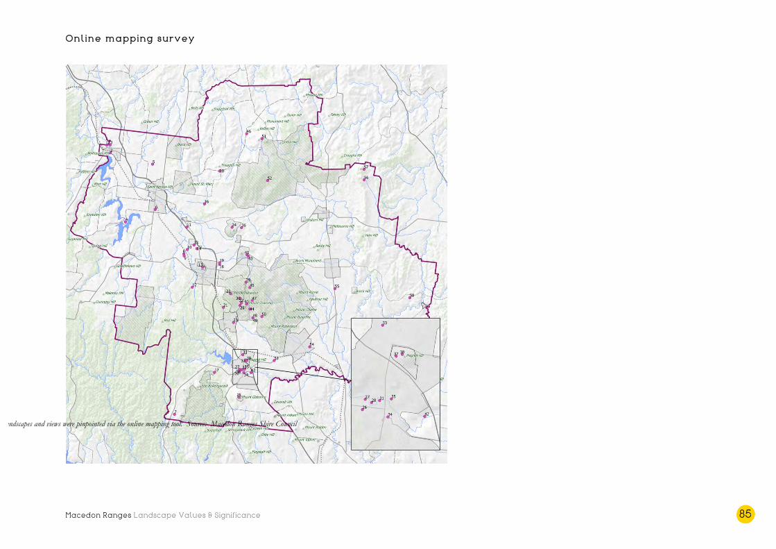
Macedon Ranges Landscape Values & Significance 85
Online mapping survey
Landscapes and views were pinpointed via the online mapping tool. Source: Macedon Ranges Shire Council
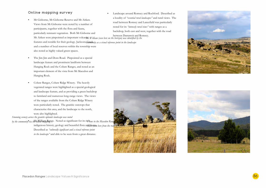
Macedon Ranges Landscape Values & Significance 86
Online mapping survey
• Mt Gisborne, Mt Gisborne Reserve and Mt Aitken.
Views from Mt Gisborne were noted by a number of
participants, together with the flora and fauna,
particularly remnant vegetation. Both Mt Gisborne and
Mt Aitken were pinpointed as important volcanic
features and notable for their geology. Jacksons Creek
and a number of local reserves within the township were
also noted as highly valued green spaces.
• The Jim Jim and Dons Road. Pinpointed as a special
landscape feature and prominent landform between
Hanging Rock and the Cobaw Ranges, and noted as an
important element of the vista from Mt Macedon and
Hanging Rock.
• Cobaw Ranges, Cobaw Ridge Winery. The heavily
vegetated ranges were highlighted as a special geological
and landscape feature, and as providing a green backdrop
to farmland and numerous long-range views. The views
of the ranges available from the Cobaw Ridge Winery
were particularly noted. The granitic outcrops that
characterise this area, and the landscape to the north,
were also highlighted.
• Mt William Range. Noted as significant for its rich
indigenous history, geology and beautiful flora and fauna.
Described as “culturally significant and a visual reference point
in the landscape” and able to be seen from a great distance.
• Landscape around Romsey and Rochford. Described as
a locality of “essential rural landscapes” and rural views. The
road between Romsey and Lancefield was particularly
noted for its “intensely rural views” with ranges as a
backdrop, both east and west, together with the road
between Darraweit and Romsey.
Mt William (seen here on the horizon) was identified by the
community as a visual reference point in the landscape
Views to the Macedon Ranges from various locations across the
Shire (seen here from the road to Riddells Creek) were pinpointed
Stunning scenery across the granitic uplands landscape was noted
by the community via the online mapping

Macedon Ranges Landscape Values & Significance 87
Community questionnaire
A newsletter was prepared to advertise the community consultation
process, and to outline the various methods by which people could
provide information and feedback. A questionnaire was included
in the newsletter, with the following questions:
1. Which natural landscape(s) are most significant within
the Shire? Why are they significant?
2. Which views are most scenic or important, and why?
3. Special landscapes can be protected and managed
through the Planning Scheme with the Significant
Landscape Overlay. Are you supportive of this
approach?
4. The Significant Landscape Overlay still allows
development to occur, but requires a planning permit so
that it can be carefully considered. Are there any types
of development that you believe should be exempted
from this requirement?
5. If the Significant Landscape Overlay was implemented,
which areas should be the priority? Are there any
landscapes that you believe are at risk of losing their
scenic values or significance?
Eight respondents completed the questionnaire (hard copy or
online), and a summary of the responses is provided below.
1. Significant landscapes
• The whole Shire
• Mt Macedon, Macedon Ranges and Hanging Rock
• Waterway corridors; Deep Creek
• Broad expanses of landscape with a balance between
farming and native vegetation
• Winding back-roads with views through roadside
vegetation
• Grasslands
• Farmland to the west of Honour Avenue, Woodend (to
the north of Golf Course Hill)
• Sidonia Hills and the Cobaw Ranges
2. Scenic or important views
• View from Camels Hump, north
• To and from the Macedon Ranges in all directions
• Treed boulevards into townships – the views and the
driving experience
• Long views of skies and clouds
• Close-up details of birds, trees, shrubs and grasses
• Views of the Sidonia Hills from Fordes Lane, especially
with a full moon rising over the Cobaws
• View of Hanging Rock – however, some structures
within the reserve should be removed and rebuilt more
sensitively
3. Significant Landscape Overlay support
• Yes (unanimous), provided they are robust
• Utilise the SLO to strengthen wildlife corridors e.g.
completion of the corridor from Black Hill Reserve to
the Cobaws
4. Significant Landscape Overlay exemptions
• Nil (unanimous)
• No – all built structures should require a permit to guide
colours and materials
5. Priority or at risk landscapes
• Grasslands on private property
• Area to the immediate north west of the Woodend
township boundary (Golf Course Hill and surrounds) –
view under the Avenue of Honour across farmland to
the west is “ever-changing and always impressive.”
• Views from Fordes Lane across the Sidonia Hills should
be protected as a “magnificent ‘Australian’ view.”
• Whole Shire requires a more considered and sympathetic
approach to infrastructure development
• Not only iconic landscapes, but smaller hills and ranges
• The rolling hills and rural landscapes; the spaces between
the features
• Area between Mt Macedon and the Cobaw Ranges
• Edges of townships require containment

Macedon Ranges Landscape Values & Significance 88
Additional submissions
Nine Additional detailed submissions were received during the
community engagement phase of the project. The key points from
the correspondence, of relevance to this study, are outlined below:
• Stanley Park is valued as “one of the most significant natural
features of the Shire.”
• The Shire is under enormous pressure to retain its
natural values
• Focus of protection should be on natural values, sense of
rural landscape, pasture, grazing, bushland, views of
mountain peaks
• Subdivision is leading to severe degradation of the “rural
feel” of the area
• The study should identify and protect the lesser-known
mountain ranges, including Mt William, Mt Gisborne, Mt
Bullengarook, Mt Charlie, Mt Robinson, Mt Towrong
and Mt Aitken
• Landscapes should be considered as a ‘whole’ rather than
as siloed sites – keep in mind the ‘big picture’
• Rolling hills and rural aspects of South Gisborne are
important as the southern gateway to the Shire – views
of Mt Aitken important here
• “Fringes and boundaries” contribute to landscape vistas
• Rural boundary north of Kyneton is important as a
buffer for Turpins Falls
• Mt Gisborne internationally important for its Scoria
Cone woodlands
• A list of additional reference documents was also
provided by one submitter, and have all since been
reviewed as part of this study
• Concern that the landscapes of the eastern part of the
Shire are overlooked
• “Trees, plant life and green landscapes enhance our mood, health
and wellbeing.”
• Concern about open landscapes being developed for
houses “with not much space between them.”
• The mountain range is a defining feature of the Shire –
views change, and it changes colour with the time of day
and seasons
• Concern that housing estates will link up and the area
will resemble suburbs of Melbourne
• The benefits of tourism are over-stated; it is damaging to
the environment
• Erosion, degradation etc. have occurred across the rural
living landscape between Mt Bullengarook, Mt Gisborne
and Mt Macedon – good planning is required to reverse
these impacts
• A full critique of the Central Victoria Landscape Assessment
Study (2015) was also provided, and issues raised have
been included and/or addressed by this study
Many additional viewing locations were noted as scenic or
beautiful, including:
• Intersection of Crooked Road & Boundary Road,
looking north
• Crooked Road, 1km from Ochiltrees Road (at the top of
the hill), looking south
• Darraweit-Bolinda Road, 1km from Melbourne-
Lancefield Road, looking west
• Intersection of Springfield Road & Buckleys Lane,
Springfield, west view
• Buckleys Lane, Romsey
• Mumfords Road, Hesket
• 1km east of corner of Tantarbaroo and Mt William
Roads
• East of Lancefield Road, just north of Romsey
• Romsey-Woodend Road, looking west from Straws Lane
to Lavender Farm Road
• Kerrie-Mt Eliza Road, looking south
• Grahams Track, Lancefield
• Ochiltrees Road at harvest time
• Romsey–Wallan Road, past Toomeys Lane
• Romsey-Woodend Road, between Glenfern Road and
Waterworks Road – rich soils, forest, valleys stretching
either side, grasslands, dams and stock, and mature
roadside vegetation, all with a background of the
Macedon Ranges and Hanging Rock
• The landscape between Romsey-Woodend Road,
Newham, Rochford and Monument Road – mix of
mature vegetation, open plains and farmland

Macedon Ranges Landscape Values & Significance 89
• The Lancefield “bowl”, being the landscape generally
between Rochford, Mt William/Springfield Hills, north
of Romsey and the Cobaw Ranges – vegetation, forest,
land slopes and rich soils
• Deep Creek and surrounding hills and Tantaraboo, near
Chintin – landscape and rolling hills, differences between
this area and the plains
• Macedon/Romsey rolling hills, eastern edge where land
drops off
• Romsey-Wallan Road, where it crosses Deep Creek –
farmland views and views to the Macedon Ranges
• No. 3 Creek Road (around Springfield) – landforms,
vegetation and farms
Rolling hills around Deep Creek, near Chintin The rocky apex of the Three Sisters of the McHarg Ranges
View of Mt Macedon across the fields adjacent to Chanters Lane

Macedon Ranges Landscape Values & Significance 90
Central Victoria Landscape Assessment Study (2015)
Extensive consultation was undertaken in association with the
preparation of the Central Victoria Landscape Assessment Study
(CVLAS) in 2014/15, and many submissions to the study were
received from Macedon Ranges Shire community members.
Engagement methods included community newsletters, an online
photo exercise, and the opportunity to comment on draft
landscape character and significance material.
Feedback relating to the landscapes of the Macedon Ranges Shire
included:
Key characteristics
• The views of the Macedon Ranges and villages in farming land
near Riddells Creek
• Rural farming character around the Macedon Ranges
• Camels Hump, Mount Macedon shows a mix of strong natural
features and vegetation along the western part of the Cobaw biolink
Significant landscapes, views and features
• View from Mount Towrong towards Mount Macedon
• View from Straws Lane looking north, north-west
• Views towards Hanging Rock, particularly from Colwells Road.
Features and aspects that were identified because of their social,
environmental, historical or other value included:
• Social and historical values – Rail bridge, Malmsbury
• Cultural heritage – Hanging Rock.
Threats to places and features that were identified included:
• Residential subdivisions / developments changing or blocking the
views towards Macedon Ranges
• Residential subdivisions / development changing the rural farming
character and bush character of the area
• The environmental impact of events at Hanging Rock.
Photos of the following landscapes or features, and threats to
landscapes, were provided as part of the online photo exercise:
• Distant view of Macedon Ranges
• Avenue of Honour, Woodend (x 2)
• Macedon Ranges from Lancefield-Kilmore Road
• Mt Gisborne from Lancefield-Kilmore Road
• Gisborne Marshlands Reserve, with distant view of Mt
Macedon
• Established, exotic trees in Gisborne (x 3)
• Trees in the Macedon Ranges (x 2)
• View of Macedon Ranges from Camels Hump
• Dry fern and waterfall gully in Stanley Park, and a
contrasting photo with the waterfall running
• Malmsbury Botanical Gardens, train station, railway
viaduct, Coliban River and church
• Rural landscape surrounding Malmsbury
• Mt Macedon from Straws Lane
• Hanging Rock with frost in the surrounding paddocks
• Hanging Rock pinnacle
• View from Mt Towrong
• Hanging Rock at sunset
• Landscape surrounding Riddells Creek
• Wildflowers in Stanley Park Nature Reserve
• Blocking of views of Macedon Ranges by exotic
vegetation associated with rural living properties
• Mt Gisborne obscured by hedging (x 2)
• Pollution/vandalism impacts on Jacksons Creek and
Stanley Park
• Gisborne southern entry to township – established street
trees threatened by road widening (x 2)
• House on a ridge to the east of Hanging Rock
• Scattered buildings in the landscape detracting from
foreground and middle ground views of the Macedon
Ranges
• Rural views around Woodend – under threat from
subdivisions
• Mt Macedon street trees under threat from vehicular
traffic/parking
• Structures in hanging Rock Reserve detracting from its
setting and from views of the feature
Source: Central Victoria Landscape Assessment Study Consultation and
Community Values – Appendix C