m-25 west bengal - kalpavrikshkalpavriksh.org/images/cca/directory/m-25 west bengal.pdf · ......
TRANSCRIPT

West Bengal
777
state
chap
ter - w
est b
en
gal
West Bengal - an introduction
Location and biogeographySituated between 21°38’ and 27°19’N latitudes and 85°50’ and 89°50’ E longitudes, West Bengal
stretches from the Himalayas in the north to the Bay of Bengal in the south. West Bengal is bounded by five Indian states and three countries: Sikkim to the north, Bhutan to the north-east, Assam and Bangladesh to the east, Nepal, Bihar and Jharkhand to the west and Jharkhand and Orissa to the south-west. The total geographic area of the state is 88752 sq km. West Bengal has a 650 km-long coastline.
Due to altitudinal variations, the state experiences temperature ranging from below freezing point in the hills during winter to about 45°C in the southern plains during the summer. The climate varies from moist-tropical in the south-east to dry-tropical in the south-west, and from sub-tropical to temperate in the mountains of the north. At the higher altitudes (above 1800 m) of Darjeeling district, severe frost formation and snowfall occur in winter.
Annual rainfall of the state in the northern mountains and the sub-montane region is 2000-6000 mm, in the south-western region it is 900-1400 mm and in the coastal region it is 1700 mm. Around 11880 sq. km (13.4 per cent) of the total geographical area is under forest cover. The major rivers systems in the state are Ganga, Bramhaputra and their tributaries.
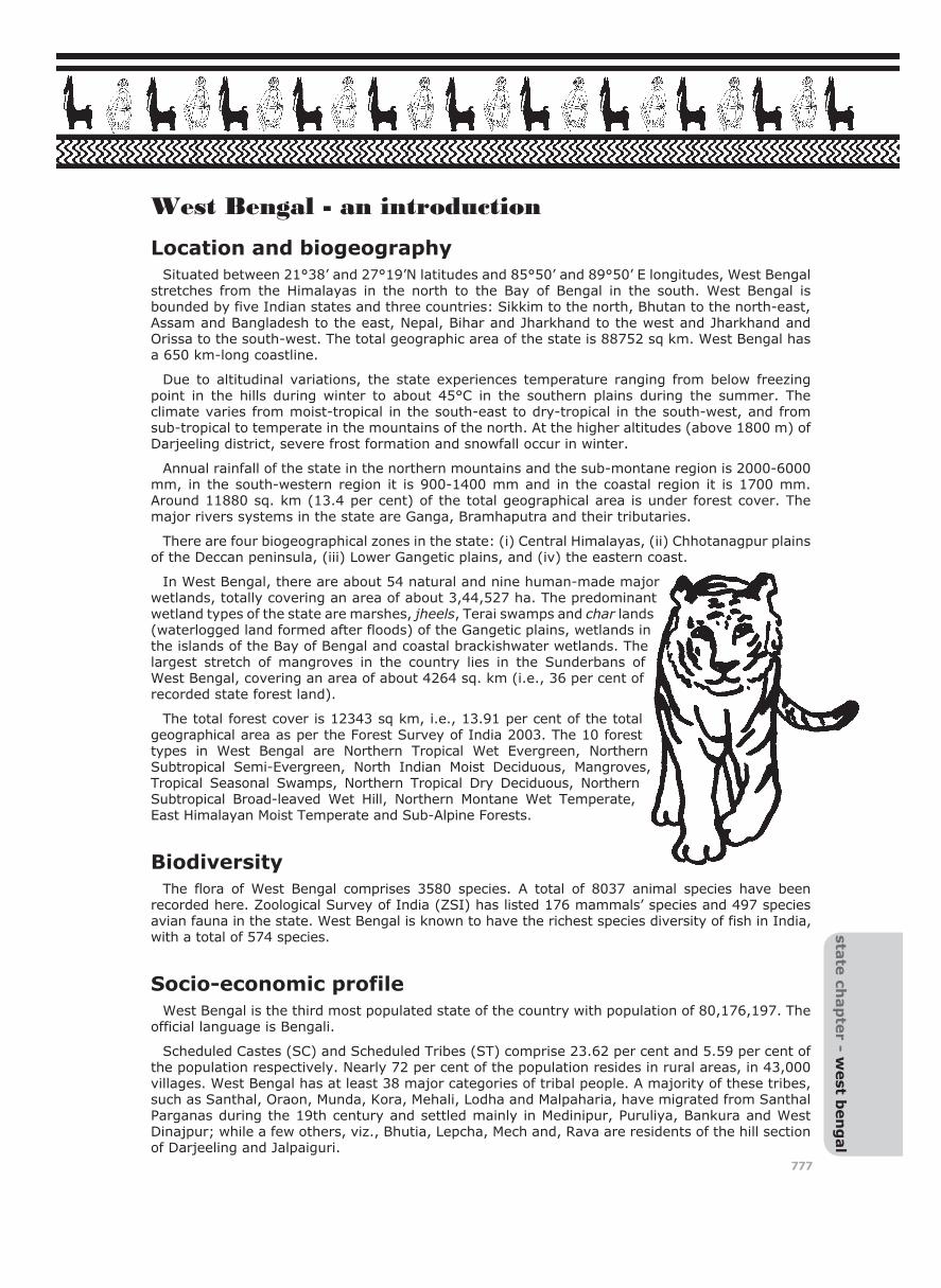
There are four biogeographical zones in the state: (i) Central Himalayas, (ii) Chhotanagpur plains of the Deccan peninsula, (iii) Lower Gangetic plains, and (iv) the eastern coast.
In West Bengal, there are about 54 natural and nine human-made major wetlands, totally covering an area of about 3,44,527 ha. The predominant wetland types of the state are marshes, jheels, Terai swamps and char lands (waterlogged land formed after floods) of the Gangetic plains, wetlands in the islands of the Bay of Bengal and coastal brackishwater wetlands. The largest stretch of mangroves in the country lies in the Sunderbans of West Bengal, covering an area of about 4264 sq. km (i.e., 36 per cent of recorded state forest land).
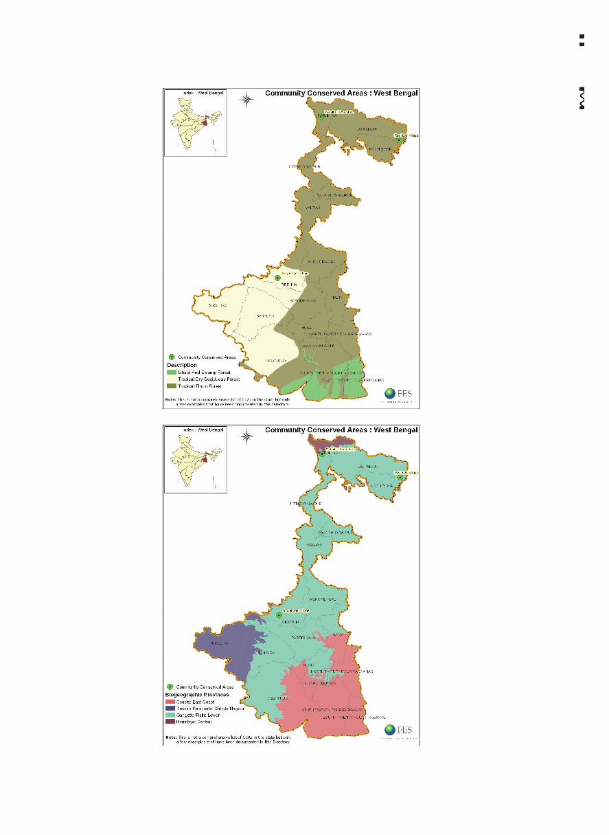
The total forest cover is 12343 sq km, i.e., 13.91 per cent of the total geographical area as per the Forest Survey of India 2003. The 10 forest types in West Bengal are Northern Tropical Wet Evergreen, Northern Subtropical Semi-Evergreen, North Indian Moist Deciduous, Mangroves, Tropical Seasonal Swamps, Northern Tropical Dry Deciduous, Northern Subtropical Broad-leaved Wet Hill, Northern Montane Wet Temperate, East Himalayan Moist Temperate and Sub-Alpine Forests.
BiodiversityThe flora of West Bengal comprises 3580 species. A total of 8037 animal species have been
recorded here. Zoological Survey of India (ZSI) has listed 176 mammals’ species and 497 species avian fauna in the state. West Bengal is known to have the richest species diversity of fish in India, with a total of 574 species.
Socio-economic profileWest Bengal is the third most populated state of the country with population of 80,176,197. The
official language is Bengali.
Scheduled Castes (SC) and Scheduled Tribes (ST) comprise 23.62 per cent and 5.59 per cent of the population respectively. Nearly 72 per cent of the population resides in rural areas, in 43,000 villages. West Bengal has at least 38 major categories of tribal people. A majority of these tribes, such as Santhal, Oraon, Munda, Kora, Mehali, Lodha and Malpaharia, have migrated from Santhal Parganas during the 19th century and settled mainly in Medinipur, Puruliya, Bankura and West Dinajpur; while a few others, viz., Bhutia, Lepcha, Mech and, Rava are residents of the hill section of Darjeeling and Jalpaiguri.

778 Community Conserved Areas in India - a directory
The main occupation is agriculture, accounting for 95 per cent of the rural population, followed by industry, fishing, honey collection and woodcutting. The principal land uses in state are agriculture, forests, wasteland, wetland, human settlement and industrial sector.
Administrative and political profile West Bengal was created as a constituent state of the Indian Union on 15 August 1947 as the
result of partition of the undivided British Indian province of Bengal into West Bengal. As in other states, there is a three-tier panchayat system, except in Darjeeling district which is governed by the Gorkha Hill Council . There are at present 3437 gram panchayats (at village level), 331 panchayat samitis (at block level) and 18 zilla parishads (at district level).
ConservationThe protected area network comprises 5 national parks, 15 sanctuaries, 2 tiger reserves, 1
elephant reserve and 1 biosphere reserve.1 Sundarbans (2585 sq km) and Buxa (759 sq km) are two tiger reserves. There are also the elephant reserves of Eastern Dooars and Mayurjharna in the state. Sundarbans is an important biosphere reserve (9,630 sq km) encompassing parts of the Ganges delta and the Brahmaputra river system.
The East Calcutta wetlands with an expanse of 12,500 ha is one of important 25 Ramsar sites designated by the Ramsar Bureau. These wetlands (22º25’ to 22º40’ N and 88º20’ to 88º35’E) are critical for their waste recycling properties. The system is described as ‘one of the rare examples of environmental protection and development management where a complex ecological process has been adopted by local farmers for mastering the resource recovery activities.’2 Five more Ramsar sites are proposed in the state3. Many species in the deltaic Sunderbans like tiger, fishing cat, Gangetic dolphin, little porpoise, adjutant stork, osprey, saltwater crocodile, olive ridley turtle, etc. have been categorized under endangered status due to habitat destruction and deterioration of water quality.
West Bengal was among the leading states in implementing Joint Forest Management (JFM). In fact, its participatory forest management programmes seem to have inspired the Indian Forest Policy of 1988, which emphasized participatory forest management in the rest of India. The forest department currently recognizes 3545 forest protection committees (FPCs); of these 17 FPCs have only women members. In Sunderbans area there are 33 FPCs with 13527 members, protecting 567 sq km of mangrove forest. The state also has 52 watershed committees for better management of watersheds. Additionally there are 99 ecodevelopment committees (EDCs) in 2 tiger reserves, 2 national parks and 3 sanctuaries, for encouraging joint participatory action for biodiversity conservation in protected areas.
Wetlands of east Kolkata form an important ecosystem in West Bengal Photo: Ashish Kothari

West Bengal 779 sta
te ch
ap
ter - w
est b
en
gal
Table 1: Some of the notable examples of community conserved areas and community involvement in protected areas
Sr.
No.
Name of Area Location Kind of Effort Area
1. Bankura Village Bankura District Protection of forest under Joint Forest Management
Not available
2. Chandana and Harinakuri
Kharagpur District Forest protection with forest department
160 ha
3. Jaldapara WLS Jalpaiguri District Protection of Wildlife Sanctuary with help of villagers
Not available
4. Jogyanagar Birbhum District Heronry protection Not available
5. Makaibari Darjeeling District Forest protection with tea estate 673 ha6. Rashikbeel Cooch Behar
DistrictProtection of wetland through formation of FPC
100 ha
7. Singalila National Park
Darjeeling District Afforestation and waste management in the NP
Not available
Out of the above, Jogyanagar, Makaibari and Rashikbeel are dealt with in detail in the case studies section.
This information about the state has been compiled by Saili S. Palande of Kalpavriksh based on: State Steering Committee for NBSAP (West Bengal Chapter), Biodiversity Strategy Action Plan, West Bengal. Prepared under National Biodiversity Strategy and Action Plan, Ministry of Environment and Forests (Government of India). (Contained in CD with reference at endnote 1)
Endnotes
1 TPCG and Kalpavriksh, Securing India’s Future: Final Technical Report of the National Biodiversity Strategy and Action Plan. Prepared by the NBSAP Technical and Policy Core Group (Delhi/Pune, Kalpavriksh, 2005).
2 http://www.ramsar.org/profile/profiles_india.htm
3 M.Z. Islam and A.R. Rahmani, Potential Ramsar Sites in India (Mumbai, IBCN:BNHS and Birdlife International, 2006).


case
stud
ies - w
est b
en
gal
781
CCA/WB/CS1/Birbhum/Jogyanagar/Heronry
Jogyanagar, Birbhum
BackgroundJogyanagar is a village situated in Birbhum district of south-western Bengal. It is located at a
distance of 13 km from Shantiniketan. This village is an abode for the open-billed storks that flock this area for nesting and breeding, and is well known for this in the region. The inhabitants of the village are Muslims and are dependent on rice cultivation.
Towards community conservationThe villagers of Jogyanagar have been traditionally protecting the habitat of the birds, which
are the mango and tamarind trees in the village. According to the villagers, the avian visitors flock in their thousands each year during the nesting season, which begins from June and ends in October.
The relationship with the birds is traditional and symbiotic. While the birds get protection in the village, villagers benefit from using the bird droppings as fertilizer in the fields.
Opportunities and constraintsVery often these birds visit the rice fields of the neighbouring villages, where they are hunted
or trapped. Any attempts by the villagers from Jogyanagar to oppose these activities leads to the action being given a communal twist. Though a series of ecological and social impact assessments of the system have been done by the Visva Bharati University and other institutions, for the villagers nothing much has come out of it. The forest department (FD) has shown little interest in supporting the villagers or protecting the birds. The villagers strongly feel that the FD must take up the responsibility of protecting the birds and also help the villagers in doing this.
ConclusionThis case shows that protection of species by local villagers often happens based on sentiments,
tradition and mutual understanding. However, given the changing socio-economic scenario, these villagers need support to be able to carry on with these efforts. This support can be legal, financial or political.
This case study has been compiled Joy Dasgupta for this Directory in 2001. He is currently at ICIMOD, Kathmandu.
For more details contact:Joy DasguptaAssistant Coordinator, Strengthening ABSBIO-EH (Access and Benefit-sharing of Biological Resources in the Eastern Himalayas)Culture, Equity, Gender and Governance (CEGG) ProgrammeInternational Centre for Integrated Mountain Development (ICIMOD)P.O. Box 3226Kathmandu, NepalTel: 00977-1-2210319 (R) 977-1-5525313 (O)Email: [email protected]

case
stu
die
s -
west
ben
gal
782
CCA/WB/CS2/Cooch Behar/Rasikbeel/Wetland
Rasikbeel, Cooch Behar
BackgroundRasikbeel is a wetland ecosystem in Cooch Behar district in northern Bengal. It is located around
34 km from the sub-divisional office at Alipurduar and around 37 km from the district headquarters at Cooch Behar.
The beel (waterbody) covers an area of 1 sq km. This wetland has been a breeding ground for diverse species of birds. The lake shelters around 40 species of migratory ducks such as mergansers that descend here during the winter season from late November till early March. The vegetation around the lake consists of a mosaic of crop fields, bamboo groves and degrading moist deciduous forest patches, along with a few plantations. The beel is a major attraction for bird watchers.
The government is also encouraging tourism here. The legal status of the wetland is reserved forest (RF) under the jurisdiction of the Forest Development Corporation (FDC).
Towards community conservationAccording to the villagers, this area had severely degraded prior to 1991. Indiscriminate hunting
of birds had led to a sharp fall in the bird population. Even the birds which came to breed here were facing serious problems because of the lake being nearly choked by the water hyacinth. This situation led to the forest department initiating a wetland restoration programme in the area. As a result, a forest protection committee (FPC) was formed in 1991. The overall management of the beels now rests with the FPC, which consists of 432 members from the three hamlets of Octamochor, Chengtimari and Rasikbeel. These three villages are forest villages, as they were part of the taungya system1 since the 1960s. These villagers are inhabited by a diversity of communities such as the Santhals, Rabhas, Kochs, Bengalis and Kharias. After the forestry operations have nearly stopped in the area, the main occupation of the villagers is rainfed agriculture and collection of forest produce. Fishing is also carried out in the lake as a supplement to the income.
The protection efforts were further strengthened in 1995 when the FDC stepped in to build a tourist complex in the area. The FDC introduced eco-tourism, with the central objective of sustaining the natural habitat of the birds while promoting tourism. Tourism would also help the local livelihoods, increasing participation of local communities in bird protection.
Impacts of community effortInvolvement of the FPC in the protection of the birds is believed to have considerably reduced the
extent of hunting in the area. Additionally, the forests in the vicinity have also regenerated.
Under an informal arrangement with the FDC, the FPC is entitled to 25 per cent of the total revenue generated through tourism. The FPC also earns from the sale of firewood and bamboo. This fund is used for common village development activities. Encouragement of tourism in the area has led to economic uplift of the villagers.
Opportunities and constraintsAlthough the FDC calls their effort an eco-tourism effort, the scheme is geared towards converting
this place into a conventional picnic spot. There are few efforts if any to facilitate tourism that is sensitive to local needs, including the needs of the birds and people. Tourism, particularly between the months of December and early February and especially on weekends, has increased many-fold. The overnight tourists are usually the ones interested in birds, but the day tourists come primarily for picnics. There are approximately 250-300 cars that visit the area on weekends. Noise pollution generated by this influx causes serious disturbance to the nesting birds.

West Bengal 783 ca
se stu
die
s - west b
en
gal
Although the FPC has managed to ban loudspeakers in the area, they have not yet managed to deal with enormous amount of waste generated by the picnickers. The rapid spread of hyacinth and the consequent choking of the native plants in the lake is another emerging problem that needs to be urgently tackled.
Despite all efforts the regular census since 2000 has shown a decline in the number of birds. The reasons for this could be a combination of the above-mentioned reasons and some others. However, currently there are proposals to declare this wetland as a legally Protected Area (PA). Once declared a PA, utilization of the lake for any purposes by the local people will be affected. This is likely to strain the relationship between the people and the FD. Whether the area needs any legal protection, and, if yes, what, is an issue that needs to be carefully assessed.
ConclusionThis case study reflects a fairly progressive effort towards conservation. The FPC has played
a crucial role in implementing economic incentives for the villagers. However in doing so it has to maintain a balance between commercialisation and resource sustenance. Hence the FPC’s objectives have to be focused on the people’s benefit along with conservation.
This case study has been compiled Joy Dasgupta for this Directory in 2001. He is currently at ICIMOD, Kathmandu.
For more details contact:Joy DasguptaAssistant Coordinator, Strengthening ABSBIO-EH (Access and Benefit-sharing of Biological Resources in the Eastern Himalayas)Culture, Equity, Gender and Governance (CEGG) ProgrammeInternational Centre for Integrated Mountain Development (ICIMOD)P.O. Box 3226Kathmandu, NepalTel: 00977-1-2210319 (R) 977-1-5525313 (O)Email: [email protected]
Endnotes
1 A system under which people were settled on government forest lands in order to carry out forestry operations for the FD. As an incentive the villagers were given some land to live on and cultivate for personal use. These villages did not have any rights over the forests or its produce.

case
stu
die
s -
west
ben
gal
784
CCA/WB/CS3/Darjeeling/Makaibari/Forest protection in a tea estate
Makaibari, Darjeeling
BackgroundMakaibari is one of the few tea estates in the world that has more land under forest cover than
tea bushes. It offers a model for conservation, while also being engaged in production. It is one of the very few community areas that has been progressive. It is located in Darjeeling district, nestled in the foot of the Himalayas. Makaibari Tea Estate (MTE) is located about 3 km south-west of Kurseong, at an elevation of 900-1200 m above sea level. The tea estate covers 673 ha but only 274 ha are cultivated with tea bushes. Makaibari is neither a PA (protected area) nor a RF (reserved forest); yet it has all the components of an ecosystem that includes people, wildlife, forests and cattle, and has managed to enrich its biodiversity and protect the forest area.
The forest of Makaibari is a sub-tropical rainforest, and the tea estate retains 70 per cent of its area under forest cover. The average rainfall varies from 3000-3500 mm and the average number of rainy days is 120 in a year. The fauna species in the forest area are in abundance, and comprise leopard, barking deer, peacock, goral, monkeys, wild boar and various bird species including the hornbill.
The villages are inhabited by the Gorkha community, who are either Hindus or Buddhists. This village follows the system of caste hierarchy, wherein the brahmins are at the higher rungs followed by the limbus and rais. The kamis occupy the lowest rung of the ladder. The number of people inhabiting this area is 1500, out of which 610 are employed at the tea estate. The women are generally pluckers, as they pluck the leaves from the tea bushes whereas the men are employed as ‘sicklers’ who trim the tea bushes. The people are spread across the villages of Makaibari, Thapthally, Kodobari, Phulbari, Cheptai, Chunagai and Koilapani.
Towards community conservationMakaibari is one of the oldest tea estates, established in 1859. It is being run by Rajah Bannerjee,
the head of the family that has traditionally owned the estate. Despite the ownership of the forests by this family, the local villagers also depend on these forests for their everyday needs such as dry wood, fodder, etc. There are many myths, beliefs, customs and traditions associated with these forests, which ensure that while meeting the needs these forests are not over-exploited. Apart from this the villagers have appointed forest rangers who patrol the forests to keep a vigil on intruders interested in timber smuggling and poaching.
A joint body committee (JBC) is the local institution that implements and monitors various socio-economic programmes and issues, including conservation of all the seven villages. It consists of elected members from each village, along with some representatives from the MTE management. All the powers are vested in the hands of the JBC, meetings of which are held weekly. The JBC also discusses the issues of overall village development. Any offender is handed over to the JBC, which in turn decides the punishment or the fine. The women have organized a Mahila Samiti, which is an offshoot of local political parties.
Forest conservation greatly benefits the tea cultivation. The tea cultivation system followed here is based on the bio-dynamic method of cultivation that was developed in 1924 by Rudolf Steiner. Under this method the tea bushes become a part of the larger ecosystem that is typical of a sub-tropical rainforest. The ground underneath the bushes is full of life, and they also attract various birds and insects. The local people prepare the compost that is crucial to this method of farming. Each household at Makaibari looks after a compost heap that consists of cowdung from their own cattle, the pruning litter from the tea bushes, and the organic waste material from their kitchens. The compost is enriched with yarrow, nettle, cowdung and other natural plant materials. This is later sold to the management of the estate, which further treats it with homoeopathic preparations. The compost is applied to the tea bushes, which represents a symbiotic relationship between the forest and the tea bushes.
The forests contribute to the tea culture such that the canopy cover prevents the direct scorching of the tea leaves, thereby retaining the moisture. Insects are attracted to the plants in the forests

West Bengal 785 ca
se stu
die
s - west b
en
gal
rather than the tea leaves. The forests also harbour the birds to feed on insect pests of tea leaves.
There are many local customs that further contribute towards the conservation of these forests. The people of Makaibari believe in the Bandevta or the jungle god, who resides in the ‘koheli’ bird (the scientific name of the bird could not be verified). This bird is never seen during the day and is only recognized by the peculiar sound of ‘ku ku’ at sunset. Another abode of the jungle god that they believe in is the chillauni tree (a kind of hardwood found in North-East Indian forests). These trees dot the forest and are found in the homesteads. A prayer is conducted during the spring season (Baisakh) by offering sindhur (vermilion powder), mithai (sweets) and supari (betelnut). Besides, a number of other trees are also considered sacred by the villagers, such as the ber that requires a pandit (priest) to conduct the ceremony, unlike the tulsi and peepal trees, which are worshipped by the villagers directly. The villagers also believe in Banjhakri, an evil spirit that roams in the forest and takes possession of small children in certain areas in the forests. This restricts the entry to those areas. These restricted areas are believed to have the highest concentration of wild animals. The cattle is stall-fed rather than taken to the forest for the fear of them being attacked by leopards. It is easier for the villagers to collect the urine and dung of the cattle, which is used in the compost in each household.
Each of the villages is provided a part of the forest for resource use and prevention of conflict among the different villagers. In order to reduce the pressure on the forests, each household has been provided with an LPG through partial contributions made by the workers. Timber for the construction of houses is procured from the nearby town of Siliguri by the MTE management. Other than fuel and fodder, some roots, tubers, fruits and medicinal plants are also extracted from the forest. There is no commercial extraction of NTFP, apart from a few women who sell fruits in the nearby town of Kurseong.
The MTE management emphasises direct and indirect benefits to the local people, in order to effectively implement forest protection along with motivating people. Every year the villagers select a part of the forest for planting tree saplings. The forest area and the plant species are decided by the respective village committees. In order to benefit the people, the management recommends one out of five trees to be a fruit tree that is to be planted and then nurtured by the people. All the villagers actively participate in protecting the forest from intruders, while a group of 18 forest rangers selected from the villages has been appointed to patrol the area. The rangers’ group comprises representatives from the management too, including the owner of the estate.
Impacts of community effortAs a result of prolonged conservation efforts, this area has a dense forest cover. The forest
cover results in the prevention of landslides and soil erosion. Peacocks that were never heard here can now be heard all over the forest. Interestingly, while the leopard population seems to be decreasing everywhere in Darjeeling, they appear to have increased in the forests of Makaibari. The forest rangers who patrol the forest area record the observations of wildlife made by them regularly in a logbook
As an incentive towards conservation efforts, a number of schemes towards social upliftment of local people have been implemented. These schemes have improved the socio-economic, health, education and employment status of the local villagers.
Opportunities and constraintsThe owner of Makaibari attributes the production of high-quality tea to the thriving sub-tropical
rain forest in the area. The tea estate of Makaibari is a perfect example of conservation, wildlife management, and meeting local livelihood needs. There have been a few instances of poaching and timber smuggling that have been confronted by the forest rangers. In the nearby tea estates there are problems such as leopard poisoning and destroying elephant corridors to cultivate tea. The people working on the other tea estates have more difficult access to fuelwood and fodder. The fact that the youth are not keen on working on the estates and are looking for better opportunities on par with their education is an issue that will have to be dealt with by the management in future.
ConclusionThis case study reflects a very progressive and fruitful result of people’s initiatives and action
towards biodiversity and socio-economic progress. However, Makaibari cannot remain as an island

786 Community Conserved Areas in India - a directory
of success; if it is not replicated in other areas to reduce deforestation, the pressure will eventually fall on the forests of Makaibari as well. The model of the tea estate of Makaibari can be replicated in many other areas as well.
This case study was written by Bahar Dutt for this Directory in 2002. She is currently with CNN-IBN.
For more details contact:Bahar DuttJ-27-A, Jangpura ExtensionNew Delhi 110014E-mail: [email protected]