location coal creek upstream of coal creek parkway photo point 5a camera point 5 bearing 192 ° goal...
Post on 19-Dec-2015
217 views
TRANSCRIPT


Location Coal Creek upstream of Coal Creek Parkway
Photo Point 5A
Camera Point 5
Bearing 192 °
Goal Monitor log movement
Duration 5 years
Regime 2 times each year
Date 10/14/08
Time 11:45 AM
Notes: Looking at a big tree slanted towards the river. Looks like it about to fall down in a few more years. Over a branch.

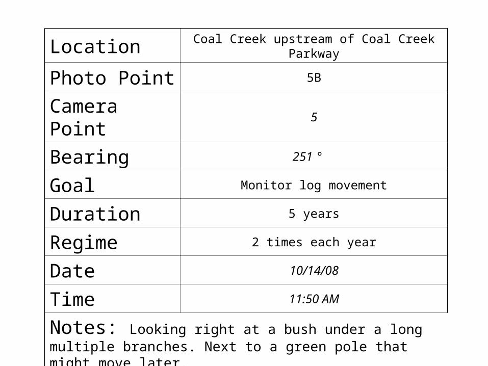
Location Coal Creek upstream of Coal Creek Parkway
Photo Point 5B
Camera Point 5
Bearing 251 °
Goal Monitor log movement
Duration 5 years
Regime 2 times each year
Date 10/14/08
Time 11:50 AM
Notes: Looking right at a bush under a long multiple branches. Next to a green pole that might move later.


Location Coal Creek upstream of Coal Creek Parkway
Photo Point 5C
Camera Point 5
Bearing 320 °
Goal Monitor log movement
Duration 5 years
Regime 2 times each year
Date 10/14/08
Time 11:53 AM
Notes: Looking at a pile of rocks across the river next to a bush.

Directions to Camera Point:
Our starting point was near a drain that sticks out from the ground like a cement stump, that
is also near a wooden bridge. From the starting point is 170 feet to our
destination/area.
Make a bearing of 131.5° W, at this point you are standing on the bridge that is next to the
drain on your left.

Photo of Starting Point Photo Point Map
1A
Key
Starting Point
Photo Point
Camera Point5
*Map shows 2nd green manhole cover as starting point
North
+
5
C5
B5
A5