list of schemes revealed on the local authority …...description other comments* scheme reply no....
TRANSCRIPT

Runnymede - List of schemes revealed on the Local Authority Search
Location Name Description Other Comments*Scheme Reply no. (for SCC use)
Addlestone High Street, Station Road and Church Street improvements.
Proposed widening and new bus lay-bys. Forms part of Runnymede Local Plan policies TC5-TC8.
RLP 2069
Englefield Green A328 St Judes Road puffin crossing. Investigate provision of crossing point in vicinity of Bagshot Road.
RLC 01/12/2014 2646
Virginia Water A30 London Road/Christchurch Road safety scheme.
Investigate provision of right turn filter signal into The Wheatsheaf.
RLC 01/12/2014 2647
New Haw New Haw Road pedestrian crossing improvements.
Investigate improved pedestrian crossing facilities in vicinity of Byfleet Road.
RLC 30/11/2015 2885
New Haw Inglehurst Stopping Up Order Department for Transport have advertised a proposed stopping up for a section of verge on south-east side adjacent 17 Pinewood Grove under reference NATTRAN/SE/S247/2433.
SUO 2992
Chertsey Eastworth Road improved pedestrain crossing facilities.
Investigate improved crosing facilities in vicinity of Tesco store.
RLC 28/11/2016 3059
Egham Hythe Chertsey Lane pedestrian crossing upgrade.
Convert pelican crossing to toucan crossing. RLC 28/11/2016 3060
Addlestone Church Lane improved crossing facilities.
Investigate possible crossing improvements between School Lane and Brighton Road.
RLC 28/11/2016 3061
Egham Egham Hill Puffin Crossing. Provision of a puffin crossing near the junction with Middle Hill.
SCCPN 3105

Various Runnymede Parking Review 2018 Proposed waiting restrictions in Addlestone, Chertsey, Egham, Englefield Green, Thorpe, Lyne, Longcross, Ottershaw/Row Town and New Haw/Woodham
SCCPP 3401-3409
* RLC - Runnymede Local Committee. Available to view at www.surreycc.gov.uk* RLP - Runnymede Local Plan. Available to view on Runnymede Borough Councils Website.* SCCPP - Surrey County Council Parking Pages, available to view at www.surreycc.gov.uk/parking.* SUO - Stopping Up Order. Available from Department of Transport by e-mailing [email protected] and quoting the reference*SCCPN - Surrey County Council Public Notices webpage. Available to view at www.surreycc.gov.uk/roads-and-transport/highways-public-notices*SCCCP - Surrey County Council Consultation Pages, search 'Bagshot Village Improvements' at www.surreycc.gov.uk

Spelthorne - List of schemes revealed on the Local Authority Search
Location Name Description Other Comments* Scheme Reply no. (for SCC use)
Ashford B3003 Clockhouse Lane accessibility improvement.
Introduce pedestrian/cycle bridge over railway line. SLTS&FP 1133
Ashford A308 Staine Road West / Ashford Road / School Road junction improvements.
Provision of pedestrian crossing points and improved turning facilities.
SLTS&FP 1808
Staines & Ashford Kingston Road cycle link. Provision of off-carrigeway cycle link between Knowle Green and Ashford Road.
SLTS&FP 2625
Shepperton Charlton Lane / Charlton Road / New Road junction improvement.
Investigate provision of roundabout to reduce congestion.
SLTS&FP 2628
Sunbury Cadbury Road - Chertsey Road junction improvement.
Investigate new and improved pedestrian crossing facilities.
SLC 15/12/2014 2746
Sunbury Staines Road West / Cadbury Road / Windmill Road junction improvement.
Investigate improved pedestrian facilities. SLC 15/12/2014 2748
Staines A308 London Road cycle improvements.
Provision of shared footway/cycleway and provision of pedestrain crossing between Crooked Billet roundabout and Iron Bridge.
WSSTP 2947
Staines Staines Train Station - Crooked Billet cycleway.
Provision of directional signing along Station Approach, Rosefield Road and Greenlands Road.
WSSTP 2949

Staines - Stanwell Stanwell Moor Road cycleway improvement.
Widening existing facility and provision of pedestrain crossings.
WSSTP 2950
Stanwell Park Road cycle improvement. Widening existing facility and provision of pedestrain crossings.
WSSTP 2951
Stanwell Stanwell village cycle improvements.
Provision of network of pedestrain and cycling routes using quiet roads and greenspace.
WSSTP 2953
Staines Stopping up of highway at London Road / Fairfield Avenue.
Proposed stopping up of footway and provision of new footway as part of a redevelopment. Ref NATTRAN/SE/S247/2625
SUO 3056
Stanwell Town Lane traffic calming. Proposal for 9 traffic calming features. WSSTP SCCPN 3263
Staines Wraysbury Road pedestrian crossing.
Investigate provision of a pedestrian crossing facility. SJC 02/10/2017 3298
Ashford/Sunbury A308 Staines Road West / Chertsey Road improvement.
Investigate improvements to crossing facilities at this junction.
SJC 19/03/2018 3366
Staines A30 Crooked Billet roundabout improvements.
Investigate safety, pedestrian and cyclist improvements.
SJC 19/03/2018 3367
Ashford Feltham Hill Road safety Improvements
Investigate provision of a zebra crossing in vicinity of Spelthorne Primary School
SJC 23/07/2018 3441
Stanwell Clare Road traffic calming. Replacement speed cushions near junction with Bedfont Road.
SJC 08/10/2018 3442
Shepperton Walton Lane one-way system. Investigate amendments to existing one-way system. SJC 10/12/2018 3474

Staines Gresham Road Improvements. Investigate alterations for traffic, parking and speed management.
SJC 10/12/2018 3475
Shepperton Walton Bridge Road safety improvements.
Investigate pedestrian crossing improvements. SJC 10/12/2018 3476
Laleham Laleham Safety Improvements.
Investigate provision of pedestrain refuge, dropped kerbs, improvements to signage & road markings and possible parking improvements.
SJC 13/03/2019 3545
Sunbury French Street Safety Improvements.
Investigate provision of 20mph, traffic calming and footway/cycleway link at Oakington Drive.
SJC 13/03/2019 3546
Various Spelthorne Parking Review 2019
Proposed waiting restrictions in Stanwell Moor, Stanwell, Ashford, Sunbury Common, Lower Sunbury, Shepperton, Laleham and Staines.
SJC 13/03/2019 SCCPP
3547-3554
* SLC - Spelthorne Local Committee. Available to view at www.surreycc.gov.uk*SJC - Spelthorne Joint Committee. Available to view at www.surreycc.gov.uk* SCCPP - Surrey County Council Parking Pages, available to view at www.surreycc.gov.uk/parking.* SUO - Stopping Up Order. Available from Department of Transport by e-mailing [email protected] and quoting the reference*SCCPN - Surrey County Council Public Notices webpage. Available to view at www.surreycc.gov.uk/roads-and-transport/highways-public-notices* SLTS&FP - Spelthorne Local Transport Strategy & Forward Programme. Available to view at www.surreycc.gov.uk*WSSTP - Wider Staines Sustainable Transport Package - Please search at www.surreycc.gov.uk for further information.

Surrey Heath - List of schemes revealed on the Local Authority Search
Location Name Description Other Comments* Scheme Reply no. (for SCC use)
Camberley Yorktown Strategy Plan - Bus Gates.
Introduce bus gates at following junctions: Watchmoor Road / Moorlands Road, Stanhope Road / Queen Mary Avenue, Doman Road / Vale Road.
YSPG 877
Camberley Yorktown Strategy Plan - Pedestrian Crossing.
New toucan crossing on A30 London road to assist access to The Meadows.
YSPG 878
Camberley Yorktown Strategy Plan - Cycle Routes
Proposed cycle links with the Yorktown area. YSPG 879
Camberley Camberley Town Centre cycle network
Proposed cycle network involving A30 London Road, Knoll Road, Portesbury Road, Pembroke Broadway and Charles Street.
SHMTS 2332
Bisley A322 Bisley shared footway / cycle route.
Investigate possibility of introducing off road cycle link along A322 Guildford Road between Clews Lane and Church Lane.
SHLC 05/12/2013 2497
Camberley Town Centre pedestrian improvements.
Various pedestrian Improvements under policy TC9. CTCAAP 2657
Frimley Frimley Network Improvement Scheme
Various highway, minor traffic management and cycle improvements within the Frimley area.
SHLTS&FP 2658
West End Lucas Green Road HGV access.
Investigate proposals to improve HGV access through the narrow sections to improve safety and reduce verge damage.
SHLTS&FP 2664
Chobham High Street / Station Road junction improvement.
Investigate improving traffic flow at junction. SHLTS&FP 2665

Chobham A319 Bagshot Road pedestrian crossing.
Investigate provision of pedestrian crossing near the school. SHLTS&FP 2666
Bagshot A322 Bagshot Bypass pedestrian crossing.
Investigate provision of pedestrian crossing to improve pedestrian safety and access between Bagshot and Windlesham.
SHLTS&FP 2667
Lightwater Red Road / Macdoanld Road / Lightwater Road junction improvements.
Investigate measures to improve traffic flow and road safety, especially for right hand turns.
SHLTS&FP 2669
Lightwater Red Road pedestrian crossing.
Investigate provision of a pedestrian crossing to improve access to West End Common.
SHLTS&FP 2670
Windlesham Chertsey Road pedestrian crossing.
Investigate provision of a pedestrian crossing in the vicinity of The Sun public house.
SHLTS&FP 2671
Deepcut Deepcut redevelopment highway improvements.
Various improvements including junction capacity, safety schemes and bus cycle facilities.
SHLTS&FP 2672
Deepcut Deepcut redevelopment cycle improvements.
Various improved cycle routes and facilities. SHLTS&FP 2862
Camberley Wensleydale Drive Stopping Up Order.
Proposed Stopping up of public highway adjacent number 36. CMHTF 02/12/2015 2868
Deepcut Bellew Road Closure. Investigate formal closure of part of Bellew Road associated with nearby Princess Royal Barracks development.
2881
Chobham High Street Chertsey Road junction improvement.
Investigate possible options for improving junction. SHLC 10/12/2015 2905
Chobham A319 Bagshot Road new footway.
Investigate provision of a new footway in verge. SHLC 10/12/2015 2908

Frimley B311 Upper Chobham Road traffic calming measures.
Investigate safety improvements in vicinity of school. SHLC 10/12/2015 2909
Mytchett Coleford Bridge Road new footway.
Investigate provision of new footway. SHLC 10/12/2015 2910
Chobham Windsor Court Road stopping up.
Investigate application for stopping up of land at 1-13 Windsor Court Road.
CMHTF 11/05/2016 2980
Frimley Old Bisley Road traffic calming.
Staged provision of traffic calming features. SHLC 08/12/2016 3072
Camberley A325 Portsmouth Road pedestrain access.
Investigate provision of a pedestrain island near the M3 bridge. SHLC 08/12/2016 3073
Chobham A319 Chertsey Road traffic calming.
Investigate various options for controlling speed in the 30mph section approaching High Street.
SHLC 08/12/2016 SCCCP
3074
Camberley Park Road parking improvements.
Investigate provision of formalised parking spaces and build-outs.
SHLC 08/12/2016 3075
Camberley A30 London Road pedestrain facility.
Convert exisrting traffic island to uncontrolled pedestrain facility.
SHLC 08/12/2016 3076
Bagshot - Camberley
A30 London Road shared cycleway.
Provision of shared cycleway between Waterers Way and The Maultway roundabout.
SHLC 13/07/2017 3214
Bagshot Bagshot Village Improvements Various highway improvement options being developed. SCCCP 3218
Deepcut Deepcut Bridge Road pedestrian crossings.
Proposed puffin crossing on a raised table south of junction with Blackdown Road, and a toucan crossing on a raised table east of junction serving new development.
3274

Camberley Princess Way prohibition of pedestrians.
Closure of footway located between Ashwood House and multistorey car park, off of Pembroke Broadway.
SCCPN 3295
Camberley A30 London Road bus lane removal.
Investigate removal of bus lane between Park Street and Grand Avenue, and west of Frimley Road.
SHLC 12/04/2018 3329
Deepcut Deepcut Bridge Road highway improvements.
Provision of parking bays, crossing, traffic calming and shared footway/cycleway between Woodend and Brunswick Road.
www.mindenhurst.co.uk 3330
Various Surrey Heath Parking Review 2018
Proposed parking restrictions in Camberley, Lightwater, Bagshot, Chobham, Frimley and Frimley Green.
SHLC 12/04/2018 3332-3335
Camberley High Street Parking Restrictions.
Proposed alterations to existing parking facilities. SHLC 06/12/2018 3477
Lightwater A322 Lightwater Bypass lane reduction.
Proposed reduction to one lane northbound between A319 Gordons School Roundabout and Guildford Road.
SHLC 04/03/2019 3524
* SHLC - Surrey Heath Local Committee. Available to view at www.surreycc.gov.uk* SCCPP - Surrey County Council Parking Pages, available to view at www.surreycc.gov.uk/parking.* SUO - Stopping Up Order. Available from Department of Transport by e-mailing [email protected] and quoting the reference*SCCPN - Surrey County Council Public Notices webpage. Available to view at www.surreycc.gov.uk/roads-and-transport/highways-public-notices* YSPG - Yorktown Supplementary Planning Guidance note. Available to view at www.surreyheath.gov.uk*SHMTS - Search for 'Surrey Heath Major Transport Scheme' at www.surreycc.gov.uk* SHLTS&FP - Surrey Heath Local Transport Strategy & Forward Programme. www.surreycc.gov.uk*CTCAAP - Camberley Town Centre Area Action Plan, available to view at www.surreyheath.gov.uk* CMHT&F - Cabinet Member for Highways, Transport and Flooding. Copies of these reports are available to view at www.surreycc.gov.uk*SCCCP - Surrey County Council Consultation Pages, search 'Bagshot Village Improvements' at www.surreycc.gov.uk

Woking - List of schemes revealed on the Local Authority Search
Location Name Description Other Comments*Scheme Reply no. (for SCC use)
Knaphill / Brookwood A324 Hermitage Road pedestrian/cycle bridge.
On the west side over the Basingstoke Canal. WLTS&FP 2023
Knaphill Hermitage Road toucan crossing. Investigate possibility of crossing point north of canal. WLTS&FP 2319
Knaphill A322 Bagshot Road shared cycle route.
Investigate cycle route between Redding Way and Basingstoke Canal.
WLTS&FP 2630
Woking Six Crossroads Roundabout improvements.
Investigate provision of toucan crossings on Shores Road and Woodham Lane arms. Longer term proposal to investigate signalisation of roundabout.
WLTS&FP 2632
West Byfleet A245 Parvis Road/Camphill Road junction improvement.
Investigate possible reconfiguartion of junction and improved pedestrian facilities.
WJC 03/12/2014 2755
Old Woking Vicarage Road pedestrian crossing. Investigate provision of a pedestrian crossing in the vicinity of Loop Road.
WJC 03/12/2014 2757
Maybury East Hill safety Scheme. Investigate speed reduction measures. WJC 02/12/2015 2927
Maybury Maybury Hill safety Scheme. Investigate speed reduction measures. WJC 02/12/2015 2928
Westfield Westfield Road safety Scheme. Investigate speed reduction measures. WJC 02/12/2015 2929
Woking A320 Guildford Road pedestrian crossing and footway widening.
Investigate crossing point in vicinity of Claremont Avenue.
WJC 02/12/2015 2931
Old Woking High Street pedestrian crossing. Investigate provision of pedestrian crossing facilities. WJC 07/12/2016 3103
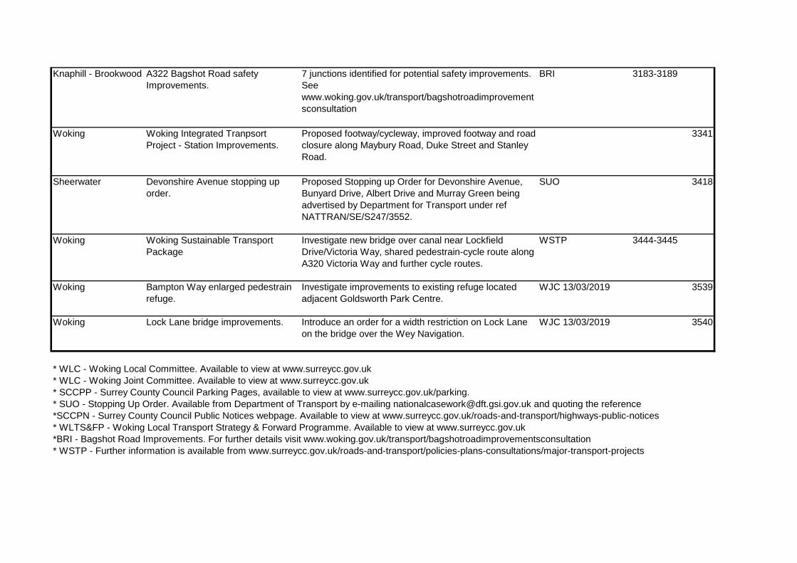
Knaphill - Brookwood A322 Bagshot Road safety Improvements.
7 junctions identified for potential safety improvements. See www.woking.gov.uk/transport/bagshotroadimprovementsconsultation
BRI 3183-3189
Woking Woking Integrated Tranpsort Project - Station Improvements.
Proposed footway/cycleway, improved footway and road closure along Maybury Road, Duke Street and Stanley Road.
3341
Sheerwater Devonshire Avenue stopping up order.
Proposed Stopping up Order for Devonshire Avenue, Bunyard Drive, Albert Drive and Murray Green being advertised by Department for Transport under ref NATTRAN/SE/S247/3552.
SUO 3418
Woking Woking Sustainable Transport Package
Investigate new bridge over canal near Lockfield Drive/Victoria Way, shared pedestrain-cycle route along A320 Victoria Way and further cycle routes.
WSTP 3444-3445
Woking Bampton Way enlarged pedestrain refuge.
Investigate improvements to existing refuge located adjacent Goldsworth Park Centre.
WJC 13/03/2019 3539
Woking Lock Lane bridge improvements. Introduce an order for a width restriction on Lock Lane on the bridge over the Wey Navigation.
WJC 13/03/2019 3540
* WLC - Woking Local Committee. Available to view at www.surreycc.gov.uk* WLC - Woking Joint Committee. Available to view at www.surreycc.gov.uk* SCCPP - Surrey County Council Parking Pages, available to view at www.surreycc.gov.uk/parking.* SUO - Stopping Up Order. Available from Department of Transport by e-mailing [email protected] and quoting the reference*SCCPN - Surrey County Council Public Notices webpage. Available to view at www.surreycc.gov.uk/roads-and-transport/highways-public-notices* WLTS&FP - Woking Local Transport Strategy & Forward Programme. Available to view at www.surreycc.gov.uk*BRI - Bagshot Road Improvements. For further details visit www.woking.gov.uk/transport/bagshotroadimprovementsconsultation* WSTP - Further information is available from www.surreycc.gov.uk/roads-and-transport/policies-plans-consultations/major-transport-projects
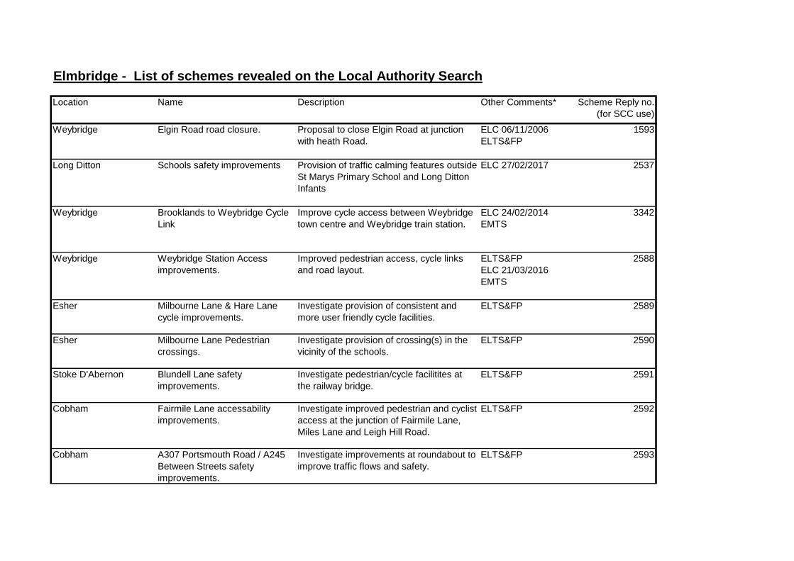
Elmbridge - List of schemes revealed on the Local Authority Search
Location Name Description Other Comments* Scheme Reply no. (for SCC use)
Weybridge Elgin Road road closure. Proposal to close Elgin Road at junction with heath Road.
ELC 06/11/2006 ELTS&FP
1593
Long Ditton Schools safety improvements Provision of traffic calming features outside St Marys Primary School and Long Ditton Infants
ELC 27/02/2017 2537
Weybridge Brooklands to Weybridge Cycle Link
Improve cycle access between Weybridge town centre and Weybridge train station.
ELC 24/02/2014 EMTS
3342
Weybridge Weybridge Station Access improvements.
Improved pedestrian access, cycle links and road layout.
ELTS&FP ELC 21/03/2016 EMTS
2588
Esher Milbourne Lane & Hare Lane cycle improvements.
Investigate provision of consistent and more user friendly cycle facilities.
ELTS&FP 2589
Esher Milbourne Lane Pedestrian crossings.
Investigate provision of crossing(s) in the vicinity of the schools.
ELTS&FP 2590
Stoke D'Abernon Blundell Lane safety improvements.
Investigate pedestrian/cycle facilitites at the railway bridge.
ELTS&FP 2591
Cobham Fairmile Lane accessability improvements.
Investigate improved pedestrian and cyclist access at the junction of Fairmile Lane, Miles Lane and Leigh Hill Road.
ELTS&FP 2592
Cobham A307 Portsmouth Road / A245 Between Streets safety improvements.
Investigate improvements at roundabout to improve traffic flows and safety.
ELTS&FP 2593
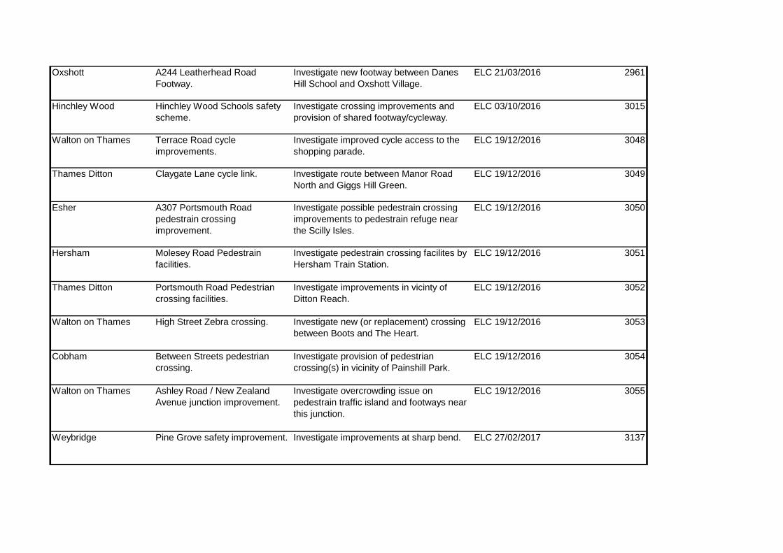
Oxshott A244 Leatherhead Road Footway.
Investigate new footway between Danes Hill School and Oxshott Village.
ELC 21/03/2016 2961
Hinchley Wood Hinchley Wood Schools safety scheme.
Investigate crossing improvements and provision of shared footway/cycleway.
ELC 03/10/2016 3015
Walton on Thames Terrace Road cycle improvements.
Investigate improved cycle access to the shopping parade.
ELC 19/12/2016 3048
Thames Ditton Claygate Lane cycle link. Investigate route between Manor Road North and Giggs Hill Green.
ELC 19/12/2016 3049
Esher A307 Portsmouth Road pedestrain crossing improvement.
Investigate possible pedestrain crossing improvements to pedestrain refuge near the Scilly Isles.
ELC 19/12/2016 3050
Hersham Molesey Road Pedestrain facilities.
Investigate pedestrain crossing facilites by Hersham Train Station.
ELC 19/12/2016 3051
Thames Ditton Portsmouth Road Pedestrian crossing facilities.
Investigate improvements in vicinty of Ditton Reach.
ELC 19/12/2016 3052
Walton on Thames High Street Zebra crossing. Investigate new (or replacement) crossing between Boots and The Heart.
ELC 19/12/2016 3053
Cobham Between Streets pedestrian crossing.
Investigate provision of pedestrian crossing(s) in vicinity of Painshill Park.
ELC 19/12/2016 3054
Walton on Thames Ashley Road / New Zealand Avenue junction improvement.
Investigate overcrowding issue on pedestrain traffic island and footways near this junction.
ELC 19/12/2016 3055
Weybridge Pine Grove safety improvement. Investigate improvements at sharp bend. ELC 27/02/2017 3137

Walton, Hersham & Weybridge
Walton Parking Review Investigate provision of new/amended waiting restrictions.
ELC 14/09/2017 SCCPP
3225-3228
East Molesey Bridge Road safety scheme. Investigate safety improvements at Walton Road/Esher Road roundabout.
ELC 14/09/2017 3229
East Molesey Walton Road casualty reduction scheme.
Investigate scheme between Esher Road and Avern Road.
ELC 04/12/2017 3266
Downside St Matthews School safety scheme.
Investigate safety improvements in vicinity of school.
ELC 04/12/2017 3267
Weybridge Oatlands Chase zebra crossing Provision of a zebra crossing near the junction with Ashley Road.
SCCPN 3302
Claygate Hare Lane safety Improvements. Consider 20mph / improved pedestrian facilities between Raleigh Drive and Loseberry Road.
ELC 05/03/2018 3321
West Molesey Abbey Walk stopping up order Proposed Stopping up Order being advertised by Department for Transport under ref NATTRAN/SE/S247/3317.
SUO 3328
Various Miscellaneous Parking Proposals 2018
Various parking alterations in Weybridge, West Molesey, Hersham, Walton and Esher.
SCCPP 3348
Cobham - Weybridge A245 Byfleet Road Pedestrain / cyclist Improvements.
Investigate possible cycle track between Feltonfleet School and Brooklands Road.
ELC 24/09/2018 3411
Cobham - Weybridge Seven Hills Road cycle route. Investigate possible cycle route between A245 Byfleet Road and Queens Road roundabout
ELC 24/09/2018 3412

Claygate - Hinchley Wood
Woodstock Lane South safety improvements.
Investigate possible new footway, speed management and safety improvements.
ELC 24/09/2018 3413
Hinchley Wood A309 Kingston Bypass cycle route.
Investigate possible new cycle route between Woodstock Lane and Scilly Isles.
ELC 24/09/2018 3414
Weybridge Weybridge town centre crossing review.
Review operation of crossings on Church Street and High Street.
ELC 24/09/2018 3415
Thames Ditton Ember Lane safety Improvements.
Investigate improvements at the sharp bends.
ELC 26/11/2018 3447
Weybridge Grotto Road/Thames Street junction safety scheme.
Investigate safety improvement scheme at this junction.
ELC 26/11/2018 3448
Weybridge Grotto Road pedestrain improvement scheme.
Investigate pedestrain improvements, possibly including a cycle route, between Oatlands Drive and Marlborough Drive.
ELC 26/11/2018 3449
Various Elmbridge Parking Review 2018/19.
Proposed alterations in East Molesey, West Molesey, Thames Ditton, Long Ditton, Esher, Hinchley Wood, Oxshott, Stoke D'Abernon, Cobham, Hersham, Walton and Weybridge
ELC 26/11/2018 SCCPP
3451-3463
Oxshott Leatherhead Road pedestrian improvements.
Investigate improvements to the pedestrain route south of the village centre.
ELC 11/03/2019 3537
Walton on Thames Sunbury Lane Prohibition. Advertise an order to legally enforce the existing bollards as this road meets the River Thames.
ELC 24/09/2018 3538
* ELC - Elmbridge Local Committee. Available to view at www.surreycc.gov.uk

* SCCPP - Surrey County Council Parking Pages, available to view at www.surreycc.gov.uk/parking.* SUO - Stopping Up Order. Available from Department of Transport by e-mailing [email protected] and quoting the reference*SCCPN - Surrey County Council Public Notices webpage. Available to view at www.surreycc.gov.uk/roads-and-transport/highways-public-notices* ELTS&FP - Elmbridge Local Transport Strategy & Forward Programme. Available to view on Surrey County Council website.*EMTS - Elmbridge Major Transport Scheme, view at www.surreycc.gov.uk/roads-and-transport/policies-plans-consultations/major-transport-projects

Epsom & Ewell - List of schemes revealed on the Local Authority Search
Location Name Description Other Comments* Scheme Reply no. (for SCC use)
Epsom - Ewell Epsom to Ewell cycle facilities. Proposed shared use cycle lane along East Street and Weston Street, along with junction improvements.
E&ELC 13/09/2010 2025
Epsom Plan E Epsom - Pedestrian Improvements.
Various pedestrian improvements within Epsom. E&EBC Plan E 2325
Epsom Plan E Epsom - Cycle Improvements. Various cycle improvements within Epsom. E&EBC Plan E 2326
Epsom Plan E Epsom - Rear servicing Proposed rear servicing for High Street via Town Hall Car Park.
E&EBC Plan E 2327
Epsom Plan E Epsom - High Street Left Turn ban.
Investigate possibility of restricting left turn from High Street (west) into Waterloo Road.
E&EBC Plan E 2329
Ewell Ewell Village Cycle Links. Investigate provision a number of cycle links within Ewell.
E&ELC 20/03/2014 2548
Epsom East Street / Church Road safety improvements.
Investigate increasing capacity at junction and providing improved pedestrian crossing facilities.
E&ELTS&FP 2600
Ewell New pedestrian/cycle bridge north of West Ewell Train Station.
Between Station Approach and Old Schools Lane. E&ELTS&FP 2604
West Ewell Signalise Chessington Road / Longmead Road.
Investigate possible signalisation to improve congestion.
E&ELC 06/03/2017 2607

Worcester Park, Stoneleigh and Ewell
A240 Kingston Road / Ewell Bypass corridor junction improvements.
Carry out junction review and remodelling at junctions with Worcester Park Road, Ruxley Lane, Thorndon Gardens, Bradford Drive / Stoneleigh Park Road, Old Kingston Road, London Road, Cheam Road (including Nonsuch Court Avenue) and Reigate Road.
E&ELTS&FP 2611
Epsom Downs A240 Reigate Road / College Road safety improvements.
Investigate possible review and remodelling of junction.
E&ELTS&FP 2612
Ewell / Epsom Ewell Bypass cycle links. Investigate cycle links between Cheam Road and London Road, London Road and Kingston Road, and Kiln Lane to Reigate Road.
E&ELTS&FP 2615
Ewell Kingston Road Cycle Links. Investigate cycle links between Kingston Road and Ruxley Lane, and Ruxley Lane to Borough boundry.
E&ELTS&FP 2616
Epsom East Street / Kiln Lane junction improvement.
Investigate capacity and pedestrian crossing improvements, along with possible Chuters Grove parking layby.
E&ELC 07/12/2015 2942
Stoneleigh Stoneleigh Park Road - Bradford Drive cycle link.
Feasibility study into allowing cyclinf along footway of Stoneleigh Parade.
E&ELC 29/02/2016 2994
Epsom - Banstead
Epsom - Banstead Sustainable Transport Package.
Various pedestrian and cycle improvements in Epsom, Banstead and Burgh Heath.
E&EMTS 2995-2998
Ewell London Road pedestrian improvements.
Investigate pedestrain access improvements at the junction with Mill Lane/St Marys Close.
E&ELC 06/03/2017 3141
Epsom Downs Yew Tree Bottom Road pedestrain access
Investigate provision of pedestrian crossing point. E&ELC 06/03/2017 3142

Epsom Fair Green Cycle Link Investigate provision of cycle link across Fair Green common.
E&ELC 06/03/2017 3143
Epsom Hook Road pedestrian crossing. Investigate provision of crossing point near Mosque (by Miles Road).
E&ELC 06/03/2017 3144
Ewell A240 Kingston Road pedestrian crossing.
Investigate crossing point in vicinity of Aldi store. E&ELC 12/03/2018 3324
Various Epsom & Ewell Parking Review 2018 Proposed waiting restrictions in Cheam, Stoneleigh, Ewell, Epsom and Epsom Downs.
E&ELC 25/06/2018 SCCPP
3359-3364
Epsom A240 Reigate Road pedestrain crossing.
Investigate crossing point near junction with Priest Hill Close
E&ELC 10/09/2018 3416
Stoneleigh A24 London Road improved pedestrain crossig facilities.
Investigate in vicinity of Anne Boleyn Court and Briarwood Road.
E&ELC 10/12/2018 3465
Cheam A232 Cheam Road improved pedestrain crossig facilities.
Investigate in vicinity of Bramley Road E&ELC 10/12/2018 3466
Stoneleigh A24 London Road cycle link. Investigate cycle link between Sparrow Farm Road and Nonsuch Park entrance.
E&ELC 10/12/2018 3467
Epsom Waterloo Road shared pedestrain / cycle route.
Investigate route linking Station Approach to the alleyway leading to Pound Lane.
E&ELC 25/03/2019 3543
Epsom Horsley Close road closure Investigate possible road closure at junction with Waterloo Road, likely on an experimantal basis.
E&ELC 25/03/2019 3544
*E&ELC - Epsom & Ewell Local Committee report. Available to view at www.surreycc.gov.uk* SCCPP - Surrey County Council Parking Pages, available to view at www.surreycc.gov.uk/parking.* SUO - Stopping Up Order. Available from Department of Transport by e-mailing [email protected] and quoting the reference*SCCPN - Surrey County Council Public Notices webpage. Available to view at www.surreycc.gov.uk/roads-and-transport/highways-public-notices

* E&ELTS&FP - Epsom & Ewell Local Transport Strategy & Forward Programme. Available to view on Surrey County Council website.*E&EBC Plan E - Epsom & Ewell Borough Council Plan E proposal. Available to view at www.epsom-ewell.gov.uk* E&EMTS - Search for 'Epsom -Banstead Major Transport Scheme' at www.surreycc.gov.uk

Guildford - List of schemes revealed on the Local Authority Search
Location Name Description Other Comments* Scheme Reply no. (for SCC use)
Worplesdon A323 Aldershot Road pedestrian facility.
Provision of a pedestrian refuge between junction with Gravetts Lane and access to Hunts Farm.
GLC 21/03/2018 1662
Guildford Woodbridge Meadows junction improvement.
Junction safety improvement scheme. WMSPD 1870
Guildford Woodbridge Meadows Cycle Improvements.
Introduction of cycle network within the estate. WMSPD 1871
Guildford town centre
Walnut Tree Close Closure. Investigate possibility of road closure north of train station as part of Guildford Town Centre Transport Package.
GLC 30/09/2015 GTCTP
2831
Guildford town centre
Walnut Bridge replacement. Investigate replacement of Walnut Bridge (linking Walnut Tree Close and Bedford Road) with a widened bridge for pedestrians and cyclists.
GLC 30/09/2015 GTCTP
2832
Guildford town centre
Guildford College Link + Investigate new pedestrian/cycle route between Walnut Bridge and Guildford College/Stoke Park.
GLC 30/09/2015 GTCTP
2833
Guildford town centre
A25 Cycle Corridor. Investigate provision of missing cycle links along the A25.
GLC 30/09/2015 GTCTP
2835
Guildford town centre
A320/A25 Stoke Crossroads access improvemnents.
Investigate provision of improved pedestrain/cycle crossing points at this junction.
GLC 30/09/2015 GTCTP
2836

Guildford town centre
A3100 London Road Station cycle link. Investigate provision of shared footway/cycleway along London Road between London Road station and Boxgrove roundabout.
GLC 30/09/2015 GTCTP
2837
Various Guildford Local Cycle Plan - Minor Improvements.
Various minor improvements to the cycle infrastructure in and around Guildford.
GLC 23/03/2016 2959
Shalford A281 The Street pedestrian refuge. Investigate provision of a pedestrian refuge near Tillingbourne Road.
GLC 23/03/2016 2964
Pirbright Avenue De Cagny traffic calming. Investigate provision of traffic calming along this road. GLC 23/03/2016 2967
Ash A323 Aldershot Road stopping up. Investigate stopping up of highway verge outside the property known as Raevom.
CMHTFR 11/05/2016 2978
Send Potters Lane stopping up. Investigate stopping up of highway verge outside number 130.
CMHTFR 11/05/2016 2979
Guildford A25 Boxgrove Road reinstatement. Reinstate footway on south side to allow use by pedestrains and cyclists.
GLC 13/12/2016 3127
Chilworth New Road improved crossing point. Improve the crossing point on the south side where the school crossing patrol operates.
GLC 13/12/2016 3129
West Clandon The Street safety improvements. Investigate possible traffic calming measures and speed reduction.
GLC 13/12/2016 3131
Guildford Woking Road safety improvements. Investigate possible traffic calming measures. GLC 13/12/2016 3132
West Horsley The Street pedestrian crossing facilities.
Investigate crossing facilities near the roundabout. GLC 13/12/2016 3133

Guildford Aldershot Road Puffin Crossing. Investigate the upgrade of the zebra crossing to a puffin crossing.
GLC 13/12/2016 3134
Guildford Guildford Sustainable Movement Corridor West
Various improvements involving road widening, crossings and cycle/pedestrian access improvements.
GTCTP 3216
Guildford A31 Farnham Road Bridge Strengthening scheme.
Investigate bridge strengthening scheme to allow 44T use.
SC 31/10/2017 3258
Tongham / Ash A331 Roundabout improvement scheme.
Investigate A331 improvements at A31 and A323 roundabouts.
GLC 13/12/2017 3277
Guildford The Chase stopping up order. Proposed Stopping up Order being advertised by Department for Transport under ref NATTRAN/SE/S247/3166.
SUO 3280
Guildford Guildford Parking Review. Various proposed parking restrictions within Guildford. GJC 19/09/2018 3417
Various Guildford Parking Review. New waiting restrictions in Ash Vale, Ash, Guildford, West Horsley, Ripley, Tongham, Chilworth, Shalford and Shere.
GJC20/03/2019 3557-3565
* GLC - Guildford Local Committee. Available to view at www.surreycc.gov.uk* SCCPP - Surrey County Council Parking Pages, available to view at www.surreycc.gov.uk/parking.* SUO - Stopping Up Order. Available from Department of Transport by e-mailing [email protected] and quoting the reference*SCCPN - Surrey County Council Public Notices webpage. Available to view at www.surreycc.gov.uk/roads-and-transport/highways-public-notices* WMSPD - Woodbridge Meadows Supplementary Planning Document. View at www.guildford.gov.uk/planningandbuildingcontroldocumentsandpublications* CMHTFR - Cabinet Member for Highways, Transport and Flooding Recovery. Available to view at www.surreycc.gov.uk* GTCTP - Guildford Town Centre Transport Package. Available to view at surreycc.gov.uk/guildfordtransportschemes* EPHEHB - Economic Prosperity, Environment & Highways Board. Available to view at www.surreycc.gov.uk

Mole Valley - List of schemes revealed on the Local Authority Search
Location Name Description Other Comments*Scheme Reply no. (for SCC use)
Dorking Mill Lane improvements Improve junction with High Street, and possibly signalise. DTCAAP 2334
Leatherhead Fortyfoot Road one-way. Investigate one-way restriction along gyratory. MVLC 04/12/2013 2486
Leatherhead Pixham Lane safety scheme. Investigate improved signage and road markings, along with provision of kerb build-outs.
MVLC 03/12/2014 2645
Beare Green Old Horsham Road Stopping Up application.
Request to stop up land at Godwins Nursery (adjacent Wren Cottage).
CMHTFR 13/05/2015 2827
Bookham Eastwick Drive / Eastwick Park Avenue access improvements.
Investigate access improvements including crossing ramps and build-outs.
MVLC 02/12/2015 2884
Leatherhead Leatherhead Sustainable Transport Package.
Proposed footway and cycle improvements around Leatherhead Town Centre.
MVMTS 3036-3038
Ashtead A24 Epsom Road pedestrian crossing.
Investigate provision of pedestrain crossing near The Greville Primary School.
MVLC 01/03/2017 3151
Hookwood A217 Reigate - Horley safety Scheme.
Investigate improvements between Longbridge roundabout and Mill Lane junction.
MVLC 13/09/2017 3233
Dorking Horsham Road Verge Parking. Investigate measures to prevent verge parking at crossing point to north of St Pauls Road West.
MVLC 30/11/2017 3278
Bookham Rectory Lane / Lower Road / Little Bookham Street pedestrian improvements.
Investigate possible pedestrian access improvements at junction. MVLC 30/11/2017 3279

Various Mole Valley Parking Review 2018 Proposed parking restrictions in Ashtead, Fetcham, Leatherhead, Bookham, Brockham, Dorking, Westcott, Abinger, Beare Green, Newdigate, Charlwood, Hookwood and Mickleham
SCCPP 3425-3439
Fetcham Fetcham Village traffic calming Investigate traffic calming features outside Fetcham Village Infant and Oakfield Junior Schools.
MVLC 05/09/2018 3440
Ashtead Dene Road traffic calming. Investigate provision traffic calming in vicinity of St Giles School. MVLC 12/12/2018 3469
Buckland A25 Reigate Road Pedestrain Island.
Investigate provision of a pedestrain island to provide access to bus stop.
MVLC 12/12/2018 3470
* MVLC - Mole Valley Local Committee. Available to view at www.surreycc.gov.uk* SCCPP - Surrey County Council Parking Pages, available to view at www.surreycc.gov.uk/parking.* SUO - Stopping Up Order. Available from Department of Transport by e-mailing [email protected] and quoting the reference*SCCPN - Surrey County Council Public Notices webpage. Available to view at www.surreycc.gov.uk/roads-and-transport/highways-public-notices*DTCAAP - Dorking Town Centre Area Action Plan. Available to view at www.molevalley.gov.uk* CMHTFR - Cabinet Member for Highways, Transport and Flooding Recovery. Available to view at www.surreycc.gov.uk* MVMTS - Search 'Mole Valley Major transport Schemes' at www.surreycc.gov.uk

Reigate & Banstead - List of schemes revealed on the Local Authority Search
Location Name Description Other Comments* Scheme Reply no. (for SCC use)
Lower Kingswood
Smithy Lane junction improvement. Safety improvement scheme at junction with A217 Brighton Road.
R&BLTS&FP 1214
Reigate & Horley High Street pedestrian priority. Proposals for High Streets in Reigate and Horley. Forms part of Reigate & Banstead Local Plan under policies MO11 and HR26.
R&BLP 2106
Redhill Watercolour Estate to NCN21 Cycle route
Adjacent Watercolours Estate R&BLC 17/09/2012 2284
Redhill Princess Way cycle route. Provision of a shared footway/cycleway between Ladbroke Road and Station roundabout, associated with possible redevelopment of Redhill train station.
R&BLC 04/03/2013 2365
Reigate A217 Reigate Hill / Gatton Bottom / Wray Lane junction improvement.
Investigate provision of signalised junction. R&BLTS&FP 2434
Redhill A23 London Road segregated footway/cycleway.
Between Princess Way (Lombard Roundabout) to Colesmead Road.
R&BLC 03/03/2014 2556
Redhill - Horley Greater Redhill Sustainable Transport Package.
Investigate provision of new/amended cycle facilities along various routes between Redhill and Horley.
R&BMTS 2673
Earlswood A23 Horley Road / Maple Road / Three Arch Road junction improvement.
Investigate improvements to improve capacity and increase safety.
R&BLTS&FP 2674
Redhill - Coulsdon
A23 Cycle Link (north). Investigate provision of shared footway/cycleway along this important transport corridor.
R&BLTS&FP 2675

Merstham A23 High Street pedestrian crossing facilities.
Investigate improved pedestrain crossing points at junction with Quality Street.
R&BLTS&FP 2676
Banstead - Kingswood
A217 cycle link. Investigate provision of shared use footway for pedestrians and cyclists between junction with Fir Tree Road and M25.
R&BLTS&FP 2677
Banstead Banstead Crossroads Improvement. Investigate provision of pedestrian crossing facilities and capacity improvements, also including junction with Banstead Road.
R&BLTS&FP 2678
Banstead A217 Brighton Road/The Drive Improvement.
Investigate junction safety improvement scheme. R&BLTS&FP 2682
Kingswood A217 Brighton Road/Waterhouse Lane junction improvement.
Investigate provision of improved pedestrian crossing facilities.
R&BLTS&FP 2683
Reigate A217 Woodhatch Crossroads safety scheme.
Investigate provision of improved pedestrian crossing facilities especially on Woodhatch Road arm of junction.
R&BLTS&FP 2684
Redhill Batts Hill safety improvements. Investigate provision of contraflow cycle facility and pedestrian crossing improvement at bottom of hill where footway ends.
R&BLTS&FP 2685
Redhill Whitepost Hill safety improvements Investigate provision of improved pedestrian crossing facilities at junctions with Brownlow Road and Shrewsbury Road.
R&BLTS&FP 2686
Redhill Blackstone Hill / The Chase junction improvement.
Investigate provision of a pedestrian crossing facility. R&BLTS&FP 2687
Reigate A25 West Street / Upper West Street safety scheme.
Investigate improved pedestrian crossing facilities. R&BLTS&FP 2688

Reigate A25 High Street / Park Lane safety scheme.
Investigate improved pedestrian crossing facilities. R&BLTS&FP 2689
Banstead Roundwood Way safety scheme. Investigate provision of a crossing point at the junction with Roundwood View.
R&BLTS&FP 2690
Kingswood St Monicas Road / Waterhouse Lane / Bonsor Drive junction safety scheme.
Investigate provision of improved pedestrian crossing facilities and capacity improvements.
R&BLTS&FP 2691
Walton on the Hill
Chequers Lane / Heath Drive junction dafety scheme.
Investigate provision of priority give way build out feature and footway extension.
R&BLTS&FP 2692
Woodhatch Prices Lane cycle route. Investigate cycle route leading to Sandcross Lane. R&BLTS&FP 2693
Banstead Croydon Lane pedestrian crossing. Investiate provision of pedestrain crossing between Sutton Lane and Longcroft Avenue.
R&BLC 14/12/2015 2895
Epsom - Banstead
Epsom - Banstead Sustainable Transport Package.
Various pedestrian and cycle improvements in Epsom, Banstead and Burgh Heath.
R&BMTS 2995-2998
Horley Langshott / The Acres waiting restrictions.
Proposed introduction of waiting restrictions, school keep clear and bus stop clearway restrictions.
R&BLC 12/12/2016 3048
Redhill Goodwood Road stopping up order. Proposed stopping up of highway verge on east side of 1 Goodwood Road, being advertised by Department for Transport under reference NATTRAN/SE/S247/2730
SUO 3114
Reigate - Hookwood
A17 Reigate to Horley Safety Scheme. Investigate a number of safety schemes along this route.
R&BLC 18/09/2017 3236
Kingswood Furze Hill raised table. Provision of a raised table near the junction with Waterhouse Lane.
SCCPN 3284

Chipstead Hollymeoak Road junction improvement. Investigate improvements at junction with Coulsdon Lane, Hollymead Road and Portnalls Road.
R&BLC 4/12/2017 3286
Various Reigate & Banstead parking review 2017/18.
Parking proposals in Woodmansterne, Banstead, Nork, Tattenham Corner, Chipstead, Tadworth, Walton on the Hill, Lower Kingswood, Hooley, Merstham, Redhill, Reigate, Earlswood, Woodhatch and Horley.
R&BLC 4/12/2017 SCCPP
3288-3294
Horley High Street amendments. Provision of two loading bays and relocating disabled parking bays.
R&BLC 04/12/2017 3297
Redhill Marketfield Road Stopping Up Order. Department for Transport advertising a stopping up order under reference NATTRAN/SE/S251/3220 regarding land bounded by High Street, Marketfield Road, Marketfield Way and Station Road.
SUO 3303
Redhill and Horley
Redhill and Horley Parking Alterations. Provision of waiting restrictions along Carlton Road in Redhill, and loading bays along Consort Way and Albert Road in Horley.
3379
Redhill Knights Place stopping up request. Request to stop-up this cul-de-sac CMH 23/01/2018 3446
Whitebushes Masons Bridge Road speed management.
Develop proposals between Spencer Way and Kings Mill Lane.
R&BLC 03/12/2018 3471
Various Reigate and Banstead Parking review 2019.
Parking proposals in Banstead, Earlswood, Reigate, Redhill, Horley, Salfords, Merstham, Nork, Tattenham Corner, Burgh Heath and Tadworth.
R&BLC 28/02/2019 SCCPP
3525-3534
* R&BLC - Reigate & Banstead Local Committee. Available to view at www.surreycc.gov.uk* SCCPP - Surrey County Council Parking Pages, available to view at www.surreycc.gov.uk/parking.* SUO - Stopping Up Order. Available from Department of Transport by e-mailing [email protected] and quoting the reference*SCCPN - Surrey County Council Public Notices webpage. Available to view at www.surreycc.gov.uk/roads-and-transport/highways-public-notices

* A25 RMS - A25 Route Management Study.* R&BLP - Reigate & Banstead Local Plan. Available to view at www.reigate-banstead.gov.uk* CMTHE - Cabinet Member for Transport, Highways and Environment. www.surreycc.gov.uk* R&BLTS&FP - Reigate & Banstead Local Transport Strategy & Forward Programme. Available to view at www.surreycc.gov.uk* R&BMTS - Search 'Reigate & Banstead Major Transport Scheme' at www.surreycc.gov.uk*CMH - Cabinet Member for Highways, www.surreycc.gov.uk

Tandridge - List of schemes revealed on the Local Authority Search
Location Name Description Other Comments*Scheme Reply no. (for SCC use)
Smallfield Redehall Road Traffic Calming. Replace existing traffic calming measures with alternative measures (exact type to be consulted on).
TLC 27/09/2013 2442
Dormansland High Street / Plough Road / Dormans Road junction improvement.
Investigate provision of a riased junction table at this location.
TLC 12/12/2014 2698
Various District wide road/junction safety schemes. Investigate improvements to i) Caterham Bypass/Godstone Road junction, Caterham; Stanstead Road and White Hill Lane, Caterham; Limpsfield Road/Slines Oak Road junction, Warlingham; Limpsfield Road, Warlingham, between Trenham Drive and Church Road; Pendell Road/Sandy Lane junction, Bletchingley; Ray Lane/Lingfield Common Road, Lingfield
TLTS&FP 2701
Caterham Pedestrian crossing improvements Investigate improved crossing facilities at Salmons Lane / Whyteleafe Road, Burntwood Lane, Guards Avenue, Godstone Road, Buxton Lane / Portley Lane, Chaldon Road and Banstead Road.
TLTS&FP 2703
Caterham / Whyteleafe
A22 Godstone Road cycle route. Investigate provision of a cycle route between Whyteleafe and Wapses Lodge Roundabout.
TLTS&FP 2704
Oxted / Hurst Green
Pedestrian crossing improvements Investigate pedestrian crossing on Pollards Oak Road and a pedestrian refuge on A25 west of Old Oxted High Street.
TLTS&FP 2705
Oxted / Hurst Green
Junction safety schemes. Investgate junction improvement at Miles Lane/Tandridge Lane and signalisation of A22 and Church Lane.
TLTS&FP 2706

Oxted / Hurst Green
Pedestrian access improvements. Investigate new footways along Wolfs Hill and Bluehouse Lane
TLTS&FP 2707
Godstone High Street pedestrian crossing. Investigate crossing point north of Tilburstow Hill Road. TLTS&FP 2708
Godstone Tilburstow Hill Road / A22 safety improvements.
Investigate footway improvements and junction review. TLTS&FP 2709
Godstone Salisbury Road closure. Investigate closure of road at junction with High Street to prevent rat running.
TLTS&FP 2710
South Godstone
Harts Lane HGV measures. Investigate measures to restrict access by HGVs. TLTS&FP 2711
South Nutfield Outwood Lane priority give way. Investigate provision of priority give way at railway bridge. TLTS&FP 2712
South Godstone
Lagham Park road widening. Investigate widening to relieve congestion and improve safety.
TLTS&FP 2713
South Godstone
A22 Eastbourne Road roundabout. Investigate provision of a roundabout at the junction with Miles Lane and Hart Lane.
TLTS&FP 2714
Godstone A25 Cycle improvements. Investigate shared footway/cycleway between Godstone and Bletchingley, and widen existing footway/cycleway between Tylers Green rounadnout and A25/A22 roundabout.
TLTS&FP 2715
Whyteleafe Whyteleafe Hill traffic calming review. Consider removal or replacement with alternative features. TLTS&FP 2716
Whyteleafe A22 Godstone Road /Whyteleafe Hill / Hillbury Road roundabout.
Investigate remodelling to improve congestion. TLTS&FP 2717
Lingfield Traffic calming measures. Investigate traffic calming measures on Newchapel Road, Crowhurst Road and Station Road.
TLTS&FP 2719

Bletchingley Pedestrian access improvements. Investigate pedestrian refuges along A25 at junctions with Rabies Heath Road and North Park Lane.
TLTS&FP 2720
Bletchingley Traffic calming measures. Investigate measures along Rabies Heath Road and Brewer Street.
TLTS&FP 2721
Bletchingley Outwood Lane junction improvement. Investigate improvement scheme at junction with A25, possible signal control.
TLTS&FP 2722
Felbridge Felbridge Pedestrian crossing facilities. Investigate crossing facilities on A264 Copthorne Road at junctions with A22 London Road and Mill Lane.
TLTS&FP 2723
Felbridge Mill Lane footway. Investigate provision of footway in vicinity of Copthorne Road.
TLTS&FP 2724
Felbridge Crawley Down Road junction Improvement. Investigate improvement to junction with A264, possible signal control.
TLTS&FP 2725
Felbridge Felbridge Cycleways Investigate cycle routes along A264, A22 and Crawley Down Road.
TLTS&FP 2726
Smallfield Smallfield footway provision. Investigate new footways along Plough Road and Redehall Road (include possible crossing point).
TLTS&FP 2727
Hurst Green Hurst Green footway improvements. Investigate footway extension along Mill Lane and Red Lane.
TLTS&FP 2728
Woldingham Church Road traffic calming. Investigate traffic calming and possibl consider 20 mph speed limit.
TLTS&FP 2729
Dormansland Dormansland footway improvements. Investigate provision of footways along Racecourse Road and Hollow Lane.
TLTS&FP 2731

Dormansland High Street / Station Road roundabout. Investigate provision of a roundabout at the junction with Mutton Hill and Wlderwick Road.
TLTS&FP 2732
Warlingham Limpsfield Road pedestrian crossing. Investigate provision of a pedestrian crossing between Warlingham Green and Trenham Drive.
TLTS&FP 2737
Lingfield Blackberry Lane/Felcourt Road safety scheme.
Investigate speed reduction and safety features at this junction.
TLTS&FP 2738
Newchapel East Park Lane improvements. Investigate safety improvements to include traffic calming and/or HGV restriction.
TLTS&FP 2739
Chaldon Rook Lane traffic calming. Investigate provision of speed control measures. TLTS&FP 2740
Chaldon Chaldon Village pedestrian crossing. Investigate provision of a crossing point along either Rook Lane or Chaldon Common Road.
TLTS&FP 2741
Oxted Stopping Up order at junction of Wolfs Hill and Home Park in Oxted.
Stopping Up application being advertised by Department for Transport under referrence NATTRAN/SE/S247/2010
SUO 2826
Warlingham Stopping Up request for Farleigh Golf Course.
Investigate application for a stopping up request on Farleigh Common (also known as Old Farleigh Road).
CMHT&F 2977
Godstone Stopping Up request for Flower Lane. Investigate application for a stopping up request outside Flint Hall Cottage.
CMHT&F 3012
Caterham Buxton Lane / Salmons Lane pedestrain facilities.
Investigate pedestrian crossing facilities near existing mini-roundabout.
TLC 09/12/2016 3083
Smallfield Wheelers Lane safety improvements. Investigate extension of 20mph limit and alterations to existing pinch point including a road table and kerb realignment.
TLC 22/09/2017 3240

Warlingham Farleigh Road traffic calming removal Investigate removal of speed cusions only, subject to public consultation.
TLC 21/09/2018 3443
Warlingham Tithepit Shaw Lane Pedestrain Refuge. Investigate provision of a pedestrain refuge at the junction with Limpsfield Road.
TLC 30/11/2018 3478
Various Tandridge Parking Review 2018/19 Proposed waiting restrictions in Caterham on the Hill, Caterham Valley, Warlingham, Whyteleafe, Tatsfield, Limpsfield, Hurst Green, Godstone and Limpsfield.
TLC 30/11/2018 3480-3488
* TLC - Tandridge Local Committee. Available to view at www.surreycc.gov.uk* SCCPP - Surrey County Council Parking Pages, available to view at www.surreycc.gov.uk/parking.* SUO - Stopping Up Order. Available from Department of Transport by e-mailing [email protected] and quoting the reference*SCCPN - Surrey County Council Public Notices webpage. Available to view at www.surreycc.gov.uk/roads-and-transport/highways-public-notices
* TLTS&FP - Tandridge Local Transport Strategy & Forward Programme. Available to view at www.surreycc.gov.uk* CMHT&F - Cabinet Member for Highways, Transport and Flooding. www.surreycc.gov.uk
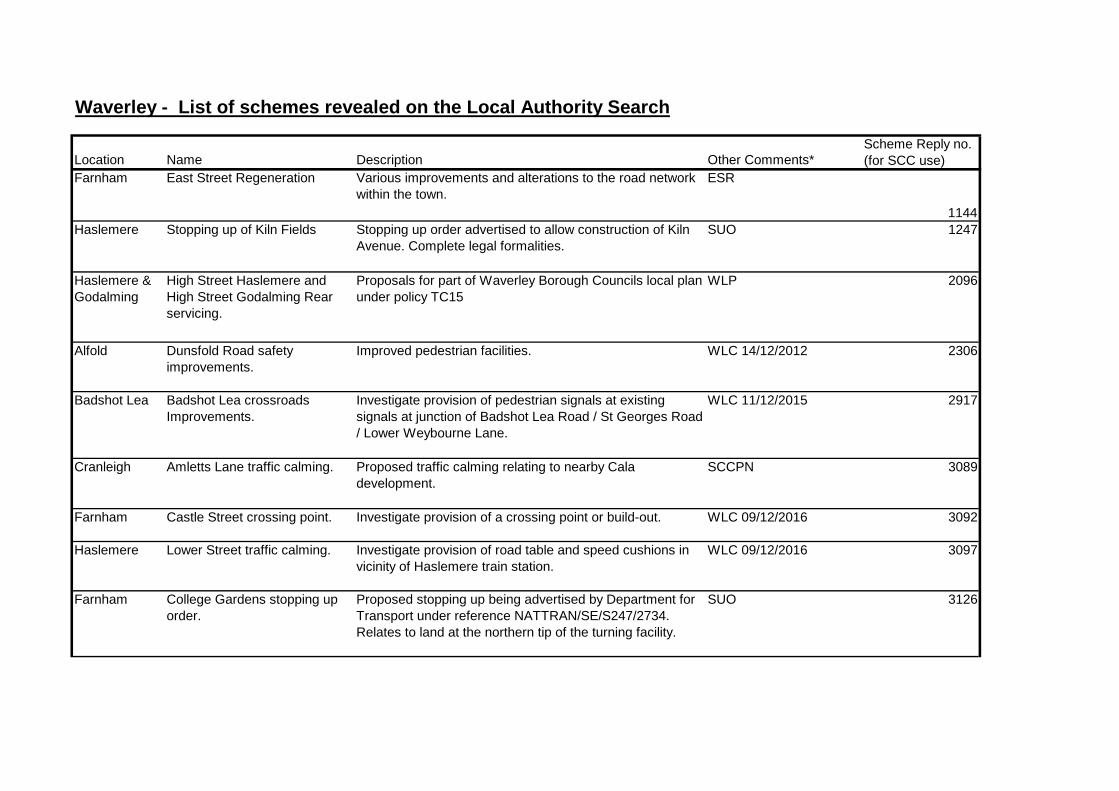
Waverley - List of schemes revealed on the Local Authority Search
Location Name Description Other Comments*Scheme Reply no. (for SCC use)
Farnham East Street Regeneration Various improvements and alterations to the road network within the town.
ESR
1144Haslemere Stopping up of Kiln Fields Stopping up order advertised to allow construction of Kiln
Avenue. Complete legal formalities.SUO 1247
Haslemere & Godalming
High Street Haslemere and High Street Godalming Rear servicing.
Proposals for part of Waverley Borough Councils local plan under policy TC15
WLP 2096
Alfold Dunsfold Road safety improvements.
Improved pedestrian facilities. WLC 14/12/2012 2306
Badshot Lea Badshot Lea crossroads Improvements.
Investigate provision of pedestrian signals at existing signals at junction of Badshot Lea Road / St Georges Road / Lower Weybourne Lane.
WLC 11/12/2015 2917
Cranleigh Amletts Lane traffic calming. Proposed traffic calming relating to nearby Cala development.
SCCPN 3089
Farnham Castle Street crossing point. Investigate provision of a crossing point or build-out. WLC 09/12/2016 3092
Haslemere Lower Street traffic calming. Investigate provision of road table and speed cushions in vicinity of Haslemere train station.
WLC 09/12/2016 3097
Farnham College Gardens stopping up order.
Proposed stopping up being advertised by Department for Transport under reference NATTRAN/SE/S247/2734. Relates to land at the northern tip of the turning facility.
SUO 3126

Godalming Ockford Ridge stopping up order no.1.
Proposed stopping up being advertised by Department for Transport under reference NATTRAN/SE/S247/2925. Relates to link road south of sports facility.
SUO 3215
Various Waverley Parking Review 2017 Proposed waiting restrictions in Farnham, Haslemere, Cranleigh, Bramley, Wonersh, Hindhead, Churt, Godalming, Milford and Wormley.
WLC 22/09/2017 SCCPP
3246-3252
Godalming Maplehatch Close stopping up order.
Proposed Stopping up Order being advertised by Department for Transport under ref NATTRAN/SE/S247/3185.
SUO 3296
Godalming Ockford Ridge stopping up order no.2.
Proposed stopping up being advertised by Department for Transport under reference NATTRAN/SE/S247/3282. Relates to highway fronting 138-162 Ockford Ridge.
SUO 3351
Various Waverley Parking Review 2018/19.
Proposed waiting restrictions in Cranleigh, Wonersh, Farnham, Godalming, Milford, Grayswood, Haslemere and Hindhead.
WLC 14/12/2018 SCCPP
3489-3499
* WLC - Waverley Local Committee. Available to view at www.surreycc.gov.uk* SCCPP - Surrey County Council Parking Pages, available to view at www.surreycc.gov.uk/parking.* SUO - Stopping Up Order. Available from Department of Transport by e-mailing [email protected] and quoting the reference*SCCPN - Surrey County Council Public Notices webpage. Available to view at www.surreycc.gov.uk/roads-and-transport/highways-public-notices*ESR - Further information at: www.eaststreetregeneration.info* WLP - Waverley Local Plan. Available to view at www.waverley.gov.uk