lifting small boats: the rise of water trails small boats.pdf · lifting small boats: the rise of...
TRANSCRIPT

Lifting Small Boats: The Rise of Water Trails
California Trails and Greenways Conference
Monterey
April 19, 2017

Panel
Lynn Sadler, Deputy Director
Division of Boating and Waterways
Ben Botkin, Planner
Association of Bay Area Governments
Kevin Takei, Shoreline Unit Manager
East Bay Regional Park District


San Francisco Bay Area Water Trail

Lake Tahoe Water Trail

Humboldt Bay Water Trail

Lakes Basin Portage
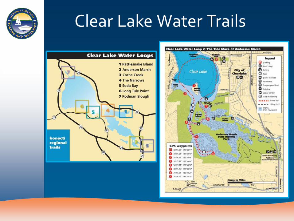
Clear Lake Water Trails

Lake Natoma Water Trail

Lower Owens River Water Trail

San Joaquin Valley Water Trail

American River Parkway Water Trail

Trinity River Water Trail

Sacramento River
–Woodson Bridge to Colusa

Almanor Basin Water Trails


Tuolumne River Regional Park


Thank You

Major funding provided by
Enhancing Access to the Bay Area’s
Largest Open Space
Ben Botkin, Water Trail Planner

Water Trail Vision
A network of launching and landing sites around the nine-county Bay Area for non-motorized small boats
www.sfbaywatertrail.org

Water Trail Vision
www.sfbaywatertrail.org
A programmatic approach to:
• Preserve and enhance existing access • Plan for future growth • Promote safety and environmental education • Increase funding • Create opportunities for multiple-day and
single-day trips

Program Implementation
1. Planning + Partnerships
2. Facilities + Grants
3. Education + Outreach
www.sfbaywatertrail.org

Planning + Partnerships
www.sfbaywatertrail.org
Photo: Lyrinda Snyderman
• Bay Access, Inc. & National Park Service
• Water Trail Act (2005) (Hancock, 1296)

Four Lead Agencies
• State Coastal Conservancy - Lead
• Association of Bay Area Governments
• California State Parks, Division of Boating and Waterways
• San Francisco Bay Conservation and Development Commission
www.sfbaywatertrail.org

Advisory Committee • Accessibility experts
• Bay Access, Inc.
• CA Assoc of Harbor Masters
• CA Fish and Wildlife Service
• US Fish and Wildlife Service
• County or Local Parks
• East Bay Regional Parks
• Hospitality Industry
• Outfitter/Tour Guide
• National Park Service
• US Coast Guard
• Wildlife/Habitat Protection Organization
• State Parks
www.sfbaywatertrail.org

Planning + Partnerships
www.sfbaywatertrail.org
• Water Trail Plan (2007), led by BCDC
• EIR (2011), led by
Coastal Conservancy
• Accessibility Plan,
(2015), led by Coastal Conservancy

Facilities + Grants
www.sfbaywatertrail.org
• Growing network through site designation process
– Facilities
– Access
– Accessibility
– Safety / Environment

Site Owners and Managers • Cities and counties
• Park and open space agencies (local, state, and federal)
• Ports and marinas
• Private businesses
www.sfbaywatertrail.org

Facilities Key Site Facilities
• Formal launch (beach, dock, ramp, etc.)
• Parking
• Restrooms
• Loading/unloading area
Additional Site Features
• Secure boat storage
• Gear staging area
• Overnight parking
• Fresh water to rinse boats
• Picnic area
• Maps or navigation signage
• Overnight accommodations

Accessibility Plan
www.sfbaywatertrail.org
• 14 Geo-Regions
• Goal of 1 broadly accessible per region
• Summarized current accessibility

Site Designation
www.sfbaywatertrail.org
35 designated sites • San Francisco Marina • Pier 39 • Angel Island • Alviso Marina • Eden Landing • Crown Beach • Berkeley Marina • Ferry Point / Miller Knox • Napa River Downtown • Big Break Regional Park • Suisun City Marina • Many more…

Water Trail Grant Program • Fund improvements to trailheads
• Funding from the Coastal Conservancy
www.sfbaywatertrail.org

Water Trail Grant Program
www.sfbaywatertrail.org

Measure AA
• $25 million / year over 20 years
www.sfbaywatertrail.org

Education and Outreach
Website
Brochure
www.sfbaywatertrail.org

Education and Outreach
ID Sign Educational Sign
www.sfbaywatertrail.org

Education and Outreach
www.sfbaywatertrail.org

Looking Forward
• More Sites!
• Maps
• Website update
• National Water Trail Designation
• Lodge-to-Lodge network
• Guidebook
www.sfbaywatertrail.org

Thank You
www.sfbaywatertrail.org

Kevin Takei, Shoreline Unit Manager
Water Trail Implementation in the East Bay Regional Park District


EBRPD PROPOSED DESGINATION
SITES # Designation Tier
Park Existing Water Access
1 Designated Tidewater Boating Center, MLK Regional Shoreline
Dock
2 Designated Ferry Point, Miller/Knox Regional Shoreline Beach
3 Conditionally Designated
Point Isabel Stairs to gravel jetty
4 Conditionally Designated
Big Break Regional Shoreline Beach
5 Conditionally Designated
Crown Memorial State Beach Beach
6 II Bay Point Regional Shoreline Beach
7 II Doolittle Launch, MLK Regional Shoreline Dock and ramp
8 II Shoreline Center, MLK Regional Shoreline Dock
9 II Edgewater, MLK Regional Shoreline Small beach

# Designation Tier
Park Existing Water Access
10 II Encinal Beach Beach
11 II Albany Beach, McLaughlin Eastshore State Park
Beach
12 II Point Pinole Regional Shoreline Beach
13 III Antioch Pier None
14 III Eckley Pier, Carquinez Strait Regional Shoreline
Small beach
15 III TXI Property, Carquinez Strait Regional Shoreline
None
16 III Lone Tree Point, San Pablo Bay Regional Shoreline
Beach
17 IV Brooks Island Regional Preserve None
18 V Browns Island None
19 V Keller Beach Beach

Tidewater Boating Center

Tidewater Boating Center

Ferry Point

Ferry Point

Point Isabel

FUNDING
• Initial Tidewater Dock - $4.3 Million from various sources – ABAG, CA Dept. of Parks & Rec, Coastal Conservancy, Boating &
Waterways
• Tidewater Dock Extension - $160K Boating and Waterways
• Ferry Point - $102K Water Trail Grant for kayak path – Other funding for site improvements from Cosco Busan and EBRPD
Measure CC funds
• Point Isabel - $185K Water Trail Grant – Other funding for site improvements from Coastal Conservancy and
EBRPD Measure WW bonds

Groundwork Richmond

Questions?
www.sfbaywatertrail.org