licking river region in kentucky - division of water | …water.ky.gov/watershed/documents/licking...
TRANSCRIPT

The Licking River Regionin Kentucky:Status and Trends
November 1998

We thank the Team members, the volunteers who have collected data and worked on watershed health issues, andPamla Wood (coordinator), Barry Tonning (principal author), Maleva Chamberlain (layout), Rick Hill (cover), Lew Kornman(photos) and Kimberly Prough (maps).
“I have really enjoyed working with a basin teamcomposed of such knowledgeable, practical andgenerous people. Their commitment and desire toinvolve many, many more people in the watershedeffort has been an inspiration to me and othersworking on watershed issues in the Commonwealth.”
Pamla WoodLicking River Watershed
Team Coordinator
1
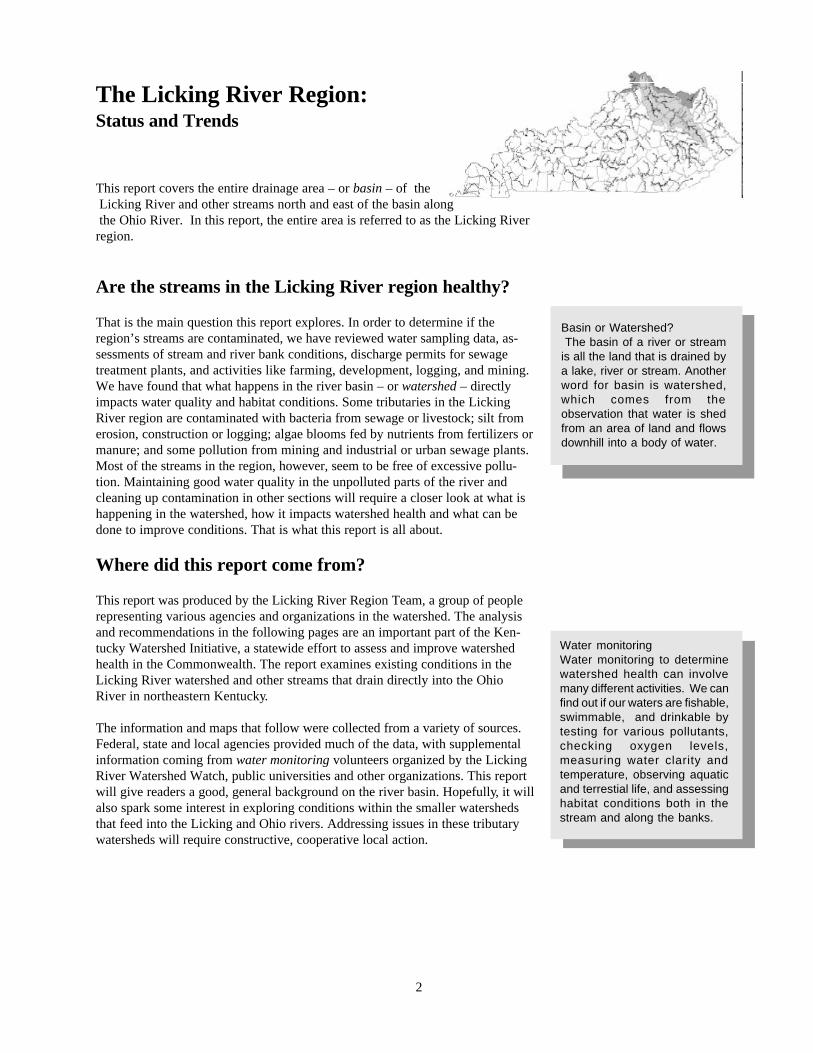
This report covers the entire drainage area – or basin – of the Licking River and other streams north and east of the basin along the Ohio River. In this report, the entire area is referred to as the Licking Riverregion.
Are the streams in the Licking River region healthy?
That is the main question this report explores. In order to determine if theregion’s streams are contaminated, we have reviewed water sampling data, as-sessments of stream and river bank conditions, discharge permits for sewagetreatment plants, and activities like farming, development, logging, and mining.We have found that what happens in the river basin – or watershed – directlyimpacts water quality and habitat conditions. Some tributaries in the LickingRiver region are contaminated with bacteria from sewage or livestock; silt fromerosion, construction or logging; algae blooms fed by nutrients from fertilizers ormanure; and some pollution from mining and industrial or urban sewage plants.Most of the streams in the region, however, seem to be free of excessive pollu-tion. Maintaining good water quality in the unpolluted parts of the river andcleaning up contamination in other sections will require a closer look at what ishappening in the watershed, how it impacts watershed health and what can bedone to improve conditions. That is what this report is all about.
Where did this report come from?
This report was produced by the Licking River Region Team, a group of peoplerepresenting various agencies and organizations in the watershed. The analysisand recommendations in the following pages are an important part of the Ken-tucky Watershed Initiative, a statewide effort to assess and improve watershedhealth in the Commonwealth. The report examines existing conditions in theLicking River watershed and other streams that drain directly into the OhioRiver in northeastern Kentucky.
The information and maps that follow were collected from a variety of sources.Federal, state and local agencies provided much of the data, with supplementalinformation coming from water monitoring volunteers organized by the LickingRiver Watershed Watch, public universities and other organizations. This reportwill give readers a good, general background on the river basin. Hopefully, it willalso spark some interest in exploring conditions within the smaller watershedsthat feed into the Licking and Ohio rivers. Addressing issues in these tributarywatersheds will require constructive, cooperative local action.
The Licking River Region:Status and Trends
Water monitoringWater monitoring to determinewatershed health can involvemany different activities. We canfind out if our waters are fishable,swimmable, and drinkable bytesting for various pollutants,checking oxygen levels,measuring water clarity andtemperature, observing aquaticand terrestial life, and assessinghabitat conditions both in thestream and along the banks.
Basin or Watershed? The basin of a river or streamis all the land that is drained bya lake, river or stream. Anotherword for basin is watershed,which comes from theobservation that water is shedfrom an area of land and flowsdownhill into a body of water.
2

Land in the Licking River region
The Licking River and the smaller streams in the region drain a diverse water-shed, with forested hills in the upper reaches, rolling farmland along the middleregions and urban/industrial development near the confluence with the OhioRiver in Northern Kentucky. The Licking River – named for the mineral springsand salt licks that attracted buffalo and other animals – begins in the highlandsof the Allegheny Plateau in Magoffin County. The river flows northwest throughthe Eastern Bluegrass for about 300 miles before emptying into the Ohio Riverbetween Newport and Covington. The two principal tributaries are the NorthFork, which joins the main stem of the river near Milford, and the South Fork,which joins at Falmouth. The river drains an area of roughly 3,600 square miles,or about ten percent of the entire state. A dam near the town of Farmers on theRowan-Bath county line – 173 miles upstream from the Ohio River – forms CaveRun Lake, an 8,300-acre reservoir that impounds 38 miles of the main stem andthe lower reaches of several tributaries. Smaller, low-water dams are found onSlate Creek, Stoner Creek, the South Fork, and other locations.
The creeks, streams and rivers of the region are mostly upland types, with mod-erate to steep grades, well-developed riffles and shoals, rocky creek bottoms, andrelatively narrow floodplains. Much of the lower half of the Licking River mainstem below Cave Run Lake and the North and South forks are subject to exces-sive siltation linked to poor agricultural practices and land clearing activities andsewage pollution from a variety of sources. Coal-bearing regions in the upperreaches of the river have been affected by siltation from surface mining and brinefrom oil wells and now have less diverse communities of organisms than in thepast.
Low-water damsLow-water dams are installedacross a stream channel to createa year-round pool of water, usuallyto supply a drinking watertreatment plant. Water flows overthe top of the dams during heavyrains. During drier conditions inthe summer, the dams hold backwater that would normally flowdownstream. While helpful forwater supply, dams restrictmovement of fish and otherorganisms.
RifflesRiffles are short runs of rapidlyflowing water, usually over rocks,downed trees and other objectsin the stream channel. Thechurning waters of riffles createhigh-quality habitat for mussels,fish, and insects that live in thestream because of the higherlevels of dissolved oxygen mixedinto the water.
3
Soils in the watershed range from thin silty clays in the hilly uplands to deeperloamy and sandier clays in the lower regions. Rock formations underlying theupland Eastsern Coalfield region include sandstone, siltstone and shale, withsome interbedded coal deposits. The river flows though the Knobs Region nearCave Run Lake and enters the rolling, limestone hills of the Bluegrass Region.Especially in Bourbon County and much of Menifee County, limestone layerscontain sinkholes, caves and underground flow channels. These formations makestreams in these areas particularly sensitive to contamination from chemicals orother pollutants on the landscape, since groundwater moves much faster throughthe passages. The streams along the Ohio River drain mostly steep, hilly areasof pasture, small farm plots and some mixed forest lands.
The headwaters region is characterized by forest vegetation typical of the EasternMesophytic Forest, one of the most biologically diverse resources in NorthAmerica. Current timber stands are second or third generation trees, with mixesof oak-poplar-hickory and pine species throughout the upper third of the water-shed. While there is still a good diversity of tree species and some excellentstands scattered throughout the region, the quality of forest resources overall ismixed due to a general lack of resource planning, poor management practicesand impacts from poor harvest techniques and skid roads. Pressure on forestresources is increasing as demand for timber rises and smaller trees becomeuseable as chip or laminated beam stock.
Farms along the middle reaches of the river produce tobacco, corn, hay, andcattle, with much of the agricultural land in pasture year-round. Urban develop-ment is more extensive near the mouth of the Licking, particularly in northernKenton and northwestern Campbell counties. Vegetation along the lower reachesis mostly turf, pasture and managed landscape, with a few remaining patches ofunconnected forest. Impervious surfaces which shed water quickly – roofs, park-ing lots and roads – are more common and concentrated in the Northern Ken-tucky area, which lies across the Ohio River from Cincinnati.
SinkholesSinkholes are openings that leadto underground passageways thatcan be very tiny or very large –even caves. The sinkholes andpassages are created when raindissolves limestone and flowsbeneath the surface along withother groundwater. Contaminantsthat flow into sinkholes easilypollute groundwater and thedrinking water wells and streamsthey connect to.
Geography and Stream HealthHow does geography affect thehealth of streams? The lay of theland, soil types, and vegetation inan area can directly affect waterquality – especially when the landis cleared or tilled. For example,basins with loose soils, steep hills,or little vegetation are oftenseverely eroded by rain storms,leaving streams and rivers muddyand subject to flooding from rapidrunoff. Vegetation can reduceflooding by slowing down runofffrom rain storms and can evenfilter out silt and othercontaminants before they reachstreams. Trees, bushes, and tallgrass along stream banks alsoreduce erosion along the channeland create valuable habitat forbirds, mammals, and othercreatures.
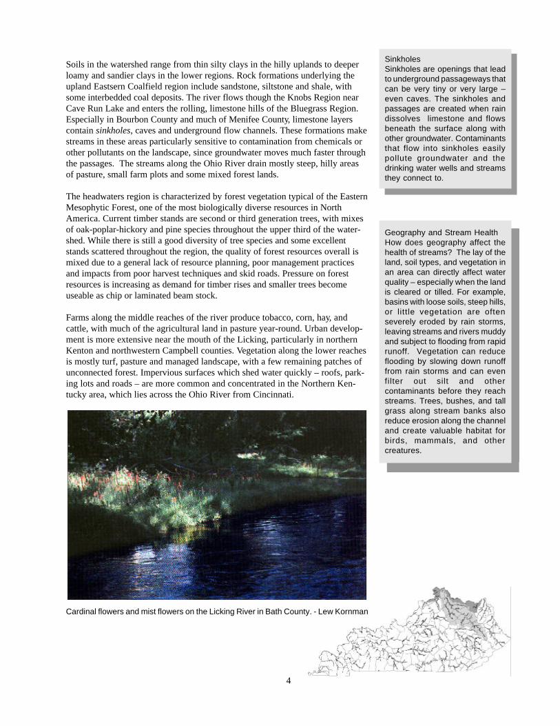
Cardinal flowers and mist flowers on the Licking River in Bath County. - Lew Kornman
4

People and the river
The Licking River and its tributaries provide a source of drinking water for about80 percent of the 340,000 residents of the basin. There are 20 drinking waterplants that draw from the river or its tributaries, more than 30 systems usingpublic wells. Some of the households in the Licking River region are connectedto one of the Some of the households in the Licking River region are connectedto one of the more than 30 sewage treatment plants that discharge treated efflu-ent into the river and its tributaries (see map). Thousands of homes use on-sitesystems, usually septic systems with tanks with drainage fields. Some house-holds illegally pipe wastewater directly from houses (straight pipes) or fromseptic tanks (straight-line septic) into streams. Other discharges affecting waterquality include flows from sanitary sewer overflows or combined sewer over-flows during times of heavy rains, briny effluents from old, abandoned oil andgas wells and some contaminated coal mine drainage in the headwaters region..
The effectiveness of waste treatment by individual residential septic systemsvaries greatly. Health departments are responsible for permitting, inspecting andresponding to complaints regarding septic or onsite wastewater treatment sys-tems, and they have stepped up oversight activities in recent years. However,straight-line and failing systems are still found in some areas, where they dis-charge bacteria, viruses, protozoa, and algae-feeding nutrients into streams.County health environmental staff are exploring the use of less expensive lagoonsystems, wetland treatment and other alternatives to address issues related tosystem costs and limiting factors like high water tables, poor soils, rocks, andsmall lots. A pilot health department program to cost-share septic system instal-lation for low income individuals proved very popular in Rowan County, andinterest exists throughout the basin and state for an expansion of this approach.
Sewage treatment plants also pose contamination problems. These may be under-sized or poorly managed or maintained. This often happens with small “pack-
Permitted discharges Discharge permits, provided forunder federal and state laws, allowthe disposal of treated effluent inthe water. This effluent can berelatively clean wastewater fromproperly functioning municipal andindustrial sewage treatmentplants, discharges fromsedimentation or treatment pondsnear mines or oil/gas wells, orstorm water from culverts thatdrain city streets.
Sanitary Sewer OverflowsNewer sewers, called sanitarysewer systems, are not designedto handle rainwater. However,rainwater and groundwater seepor flow directly into the sewer linesthrough manhole covers andcracks in joints or lines. Surfacingof sewage or bypasses can occurwhen the sewage volume exceedsthe pipe capacity. The sewagemay actually surge from the topsof manholes or cracks in themanholes, or may flow fromdischarge pipes. Theseoccurrences, referred to assanitary sewer overflows (SSO’s),occur throughout the state.
Septic systemsSeptic systems, help clean upsewage from homes andbusinesses in areas not served bysewage treatment plants. On mostsystems, the first stage oftreatment is the septic tank, wheresewage is digested in an oxygen-free or anaerobic environment.After the anaerobic process, thepartially treated waste is directedto a drain field, lagoon or wetlandfor further treatment in a moreoxygenated or aerobicenvironment. If the process isworking correctly, the relativelyclean wastewater then soaks intothe ground. Septic tanks requireperiodic maintenance pumping.Illegal straight lines pipe semi-treated water directly to streams.
5

age” plants which serve clusters of houses, schools or other facilities. Also, sewageplants may not be large enough to accommodate increases in population, resulting inrelease of raw sewage during high use.
Illegal dumping of solid waste inthe watershed has been decliningover the past five years due to newplanning and management laws,increased enforcement, public out-reach and education, and greaterawareness of the environmental andeconomic development impacts. Bylaw, solid waste removal and landdisposal services are available inevery county. However, not allhouseholds subscribe to these ser-vices (see map below). Some in-stances of dumping are still beingreported, however, and littering isstill very much a problem through-out the basin. Littering and dump-ing cost taxpayers in the region aconsiderable amount of money. Forexample, a single county can spend$6,000 to $20,000 annually to pick up litter, and during 1993-98 2,760 illegal dumps in the region were cleaned up atpublic expense. Schools, public agencies and non-governmental organizations are promoting personal responsibilityand stewardship in their efforts to reduce dumping, septic discharges and environmental degradation.
6
Combined Sewer OverflowsIn older sewer systems knownas combined sewers, thesystem is designed to collectstormwater from city streets,catch basins, yard drains, etc.If the volume of sewage andstormwater exceeds thecapacity of the sewer pipes orthe treatment plant, a portionof the sewage-stormwatermixture is allowed to bypass thetreatment process and is senteither directly to streams orrivers or is partially treatedbefore release. Bypass pipesfrom combined sewer systemsare known as combined seweroverflows (CSO’s). In theLicking River region, these onlyexist in Campbell and KentonCounties.

How do we determine watershed health?
Healthy watersheds produce clean water – water that is fishable, swimmable andsuitable as a drinking water source. Watersheds that meet these criteria support awide variety of aquatic life and are a valuable resource. State agencies mostlyfollow the guidelines in the federal Clean Water Act to determine whether or notthe quality of river and stream water is acceptable. Under the Clean Water Act,states set standards for the water based on how it is being used. These uses canconsider the high-quality values of a wild and scenic river, a stream’s importanceas a drinking water source, wildlife habitat, or other uses. The standards includebenchmarks for various parameters like dissolved oxygen, temperature, acidity,and other measurable qualities.
If a lake, river or stream meets the standards for fishing swimming, and drinkingwater sources, it fully supports its designated use (see map, centerfold). If it fallsshort on a few measures, it may only partially support its use. Failure on addi-tional counts can mean that it is not supporting its designated use. Bodies ofwater that do not support their use must have cleanup plans that identify andquantify the problem pollutants and specify how they will be reduced. Sometimesthe pollutants come from sewage treatment plants, other times they are carriedinto the water by runoff from towns, farms, new developments, or other areas.
Watershed health means more than good water chemistry. In addition to chemi-cal analyses, watershed health can be measured by observing plant and animallife. For example, certain species are indicators. Also, habitat is important towatershed and stream health. Vegetation in the riparian area - especially shrubsand trees - provides food and cover for terrestrial and aquatic life.
While state officials have information from samples collected on the LickingRiver and a few of its tributaries, most of the water in the basin has not beentested. An interagency workgroup is coordinating to increase the amount ofmonitoring conducted in the region. By working together, tax dollars can bestretched and better information provided on the condition of the watershed.Also, citizens active in the Licking River Watershed Watch have collected data tosupplement public agency information and raise public awareness. Efforts areunderway to secure greater involvement from high schools, public universitiesand civic groups for long-term citizen monitoring in the region. Further testingmay reveal other problem areas that need attention. Reducing concentrations ofpollutants that exceed state standards will involve a considerable amount of co-operative action and analysis.
MayflyLew Kornman
Kentucky Water Quality StandardsThe following parameters, or measurable criteria, are only a few of those being used to define Kentucky’s waterquality standards. The standards and units for each parameter are listed below. For example, if a water sampleshows more than 400 fecal coliform CFUs in a 100 milliliter sample, the water would be considered contaminated.
Parameter Value Units
Dissolved Oxygen >4.0 Milligrams per liter (parts per million)pH (measures acidity) 6-9 Standard units (7.0 = neutral)Fecal coliform 400 Colony-Forming Units per 100 milliliters of waterTemperature 89 Degrees Fahrenheit
Organisms as indicatorsHealthy streams have low levelsof contaminants and contain adiversity of plants and animals.Certain mussels and insect larvae(caddisfly, stonefly, mayfly) areoften used as indicators of goodwater quality, similar to the coalmine canaries used to detectpoisonous gases. Since thesemussels and larva can live only inrelatively clean water, theirpresence usually indicates thatproblems are few in that sectionof the stream. Students and adultvolunteers are monitoringwatershed health in Kentucky byobserving these indicatorsthrough the Kentucky WaterWatch program.
Riparian areaStream banks and the land alongthem are called a riparian area.With appropriate vegetation,riparian areas provide naturalprotection from pollutants thatdrain off the land. Good riparianmanagement can prevent erosionand flooding. It also providesimportant habitat for wildlifebecause it offers food, water,shelter and a travel corridor.
7

What are the water quality problems in the Licking River?
According to studies conducted over the past five years, the most common problems in the LickingRiver are nutrients, bacteria and sediments. Nutrients come from farm and residential fertilizers, live-stock manure, faulty septic systems, and other sources. The phosphorus and nitrogen – nutrients – infertilizers, manure and sewage cause algae to grow in the water. When the algae dies, it is decomposedby bacteria that use up the dissolved oxygen in the water. The loss of oxygen can cause fish to suffocateand die. Other bacteria – including some that may cause diseases in humans – can enter the water frominadequate septic systems, livestock manure or sewage plants and sewer lines that are bypassed or leakduring heavy rains. These bacteria and the viruses and other germs that often accompany them pose adisease threat to swimmers, boaters and anglers. Sediment in the water causes muddy or cloudy condi-tions, interferes with fish reproduction and feeding, increases drinking water filtration costs, and gener-ally degrades habitat. Sediment comes from poor farming, logging, development, and home buildingpractices and stream bank erosion.
Other problems in the region come from clearing away vegetation on stream banks, straightening creekchannels, undersized or poorly operated sewage treatment plants, and some industrial plants. Clearingtrees and other vegetation from streams and straightening them is often done to reduce flooding, butusually only moves the floodwaters downstream and makes the situation worse elsewhere. In addition,removing trees that shade creeks and streams causes the water to become warmer, laden with algae andless suitable for fish and other organisms. It also causes streambank erosion, which can create furtherloss of land and add sediment to streams. Bacteria in the water means that sewage collection pipes andtreatment plants in some areas need to be upgraded, along with some industrial wastewater treatmentplants.
According to the Kentucky Division of Waste Management, there are many sites in the Licking Riverregion that are contaminated or may be contaminated due to the presence of: underground storage tanks;hazardous waste facilities; landfills closed before July 1992; illegal dumps; and large tire piles, brinewells, or straight pipes.
Dealing with water quality issues will take education, time, conscious change in human habits, andfinancial support.
8
“We have the laws, regulations, statutoryfunction, and highly qualified field and officepersonnel to survey, document and reportthe wonders and beauty of our land – and,unfortunately, the degradation of it. What isneeded are committed elected officials thatare dedicated to assuring that environmentallaws and regulations are adhered to andproperly enforced so that the wonders foundwithin this region and throughout theCommonwealth remain wonders.”
Lew Kornman, Kentucky Fish and Wildlife Resources
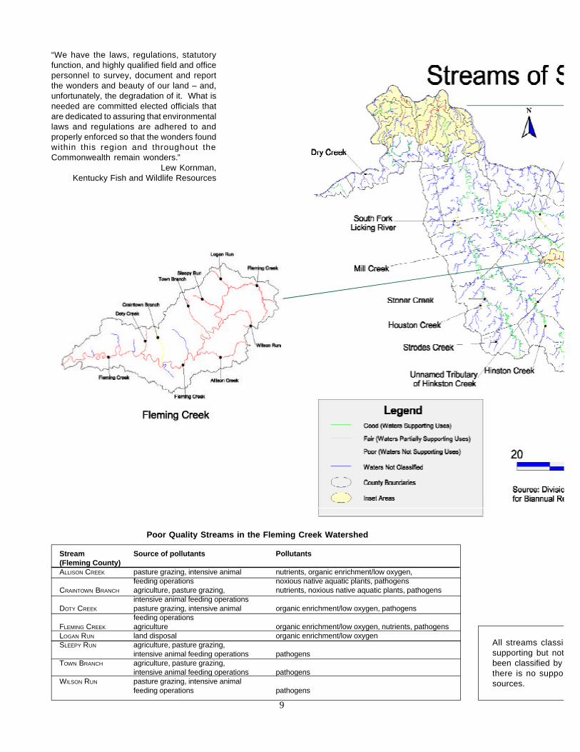
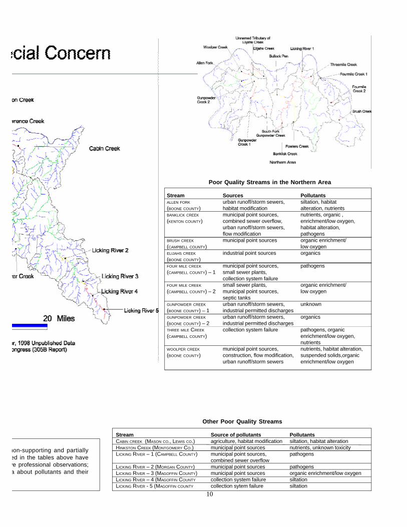
All streams classifsupporting but notbeen classified by there is no supposources.
9
Poor Quality Streams in the Fleming Creek Watershed
Stream Source of pollutants Pollutants(Fleming County)ALLISON CREEK pasture grazing, intensive animal nutrients, organic enrichment/low oxygen,
feeding operations noxious native aquatic plants, pathogensCRAINTOWN BRANCH agriculture, pasture grazing, nutrients, noxious native aquatic plants, pathogens
intensive animal feeding operationsDOTY CREEK pasture grazing, intensive animal organic enrichment/low oxygen, pathogens
feeding operationsFLEMING CREEK agriculture organic enrichment/low oxygen, nutrients, pathogensLOGAN RUN land disposal organic enrichment/low oxygenSLEEPY RUN agriculture, pasture grazing,
intensive animal feeding operations pathogensTOWN BRANCH agriculture, pasture grazing,
intensive animal feeding operations pathogensWILSON RUN pasture grazing, intensive animal
feeding operations pathogens
non-supporting and partiallyed in the tables above haveve professional observations;a about pollutants and their
Poor Quality Streams in the Northern Area
Stream Sources PollutantsALLEN FORK urban runoff/storm sewers, siltation, habitat(BOONE COUNTY) habitat modification alteration, nutrientsBANKLICK CREEK municipal point sources, nutrients, organic ,(KENTON COUNTY) combined sewer overflow, enrichment/low oxygen,
urban runoff/storm sewers, habitat alteration,flow modification pathogens
BRUSH CREEK municipal point sources organic enrichment/(CAMPBELL COUNTY) low oxygenELIJAHS CREEK industrial point sources organics(BOONE COUNTY)FOUR MILE CREEK municipal point sources, pathogens(CAMPBELL COUNTY) – 1 small sewer plants,
collection system failureFOUR MILE CREEK small sewer plants, organic enrichment/(CAMPBELL COUNTY) – 2 municipal point sources, low oxygen
septic tanksGUNPOWDER CREEK urban runoff/storm sewers, unknown(BOONE COUNTY) – 1 industrial permitted dischargesGUNPOWDER CREEK urban runoff/storm sewers, organics(BOONE COUNTY) – 2 industrial permitted dischargesTHREE MILE CREEK collection system failure pathogens, organic(CAMPBELL COUNTY) enrichment/low oxygen,
nutrientsWOOLPER CREEK municipal point sources, nutrients, habitat alteration,(BOONE COUNTY) construction, flow modification, suspended solids,organic
urban runoff/storm sewers enrichment/low oxygen
10
Other Poor Quality Streams
Stream Source of pollutants PollutantsCABIN CREEK (MASON CO., LEWIS CO.) agriculture, habitat modification siltation, habitat alterationHINKSTON CREEK (MONTGOMERY CO.) municipal point sources nutrients, unknown toxicityLICKING RIVER – 1 (CAMPBELL COUNTY) municipal point sources, pathogens
combined sewer overflowLICKING RIVER – 2 (MORGAN COUNTY) municipal point sources pathogensLICKING RIVER – 3 (MAGOFFIN COUNTY) municipal point sources organic enrichment/low oxygenLICKING RIVER – 4 (MAGOFFIN COUNTY collection system failure siltationLICKING RIVER - 5 (MAGOFFIN COUNTY collection sytem failure siltation

How does land use affect watershed health?
Environmental studies in the Licking River region demonstrate the close linkbetween land activities and water quality. Headwaters of the basin contain old oiland gas wells, abandoned coal mines, and logged areas, which can contributebrine, acidity and silt, respectively, to the river. The middle section of the basinflows through agricultural lands that produce row crops, livestock and theirperiodic by-products – water-borne sediment and manure. This manure can comefrom the horse farms in the South Fork watershed, dairies along the middlereaches of the river, beef cattle on farms in the Gateway Area, hogs, chickensand even household pets throughout the watershed.
Land activities that can impact water quality
Activity Impacts
Row cropping Siltation, erosion, chemical and fertilizer runoffLivestock production Manure runoff (excessive nutrients and bacteria), damage to streamside vegetation,
bank erosionLogging Loss of streamside trees, bank erosion, siltation from roads, increased runoffMining Acidity and sulfates from iron sulfide rocks, sediment, runoff surgesOil and gas drilling Brine from drilling, sediments, oily runoffResidential yards Lawn and garden chemical and fertilizer runoff, higher runoff velocitiesUrban development Siltation from land clearing, runoff surges (oils and metals) from roofs, roads, parking lotsIndustrial facilities Chemical runoff from material storage areas, soot deposits, runoff surges, spillsCommercial development Runoff surges (oils and metals) from parking lots, roofs; sediment from land clearingStream clearing Sedimentation, loss of wildlife/mussel habitat, loss of shading (increased temp.), floodingChannelization Increased flooding, sedimentation, loss of fish/insect habitat, loss of mussel bedsConstruction in floodplains Increased flooding, siltation, danger to life and property
11
Storm water runoff from the cities along theOhio and Licking rivers contains automotiveoils, sediment from land clearing activities,soot from cars and other sources, nutrients thatfeed algae blooms, and other urban contami-nants. Development and loss of greenspace
also causes surges in stream levels dueto rapid runoff - from roofs, roads andparking lots -which erodes streambanks and can cause localized flooding.Finally, the loss of trees, shrubs andgrasses along stream banks causesfurther instability and erosion, withresulting increases in siltation anddecreases in both instream and streambank habitat. Channelization, the clear-ing and straightening of stream chan-nels, aggravates both flooding andsedimentation, despite the commonnotion that it reduces flooding.
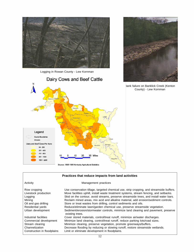
Practices that reduce impacts from land activities
Activity Management practices
Row cropping Use conservation tillage, targeted chemical use, strip cropping, and streamside buffers.Livestock production Move facilities uphill, install waste treatment systems, stream fencing, and setbacks.Logging Skid on the contour, avoid streams, preserve streamside trees, and install water bars.Mining Reclaim mined areas, mix acid and alkaline material, add erosion/sediment controls.Oil and gas drilling Store or treat wastes from drilling, control sediments and oils.Residential yards Reduce/eliminate lawn/garden chemical use, preserve streamside vegetation.Urban development Sediment/erosion/stormwater controls, minimize land clearing and pavement, preserve
existing trees.Industrial facilities Cover stored materials, control/treat runoff, minimize air/water discharges.Commercial development Minimize land clearing, control/treat runoff, reduce parking lots/road sizes.Stream clearing Minimize clearing, preserve vegetation, promote greenways/buffers.Channelization Decrease flooding by reducing or slowing runoff, restore streamside wetlands.Construction in floodplains Limit or eliminate development in floodplains.
Bank failure on Banklick Creek (KentonCounty) - Lew Kornman
Logging in Rowan County - Lew Kornman
12

Recreational resources
The rivers and streams of the Licking region provide a resource far beyond resi-dential and industrial use. Healthy watersheds support fishing, boating, hunting,hiking, biking, and other outdoor activities important for recreation, social out-ings, community development, peace of mind, and other quality-of-life ameni-ties. From the headwaters streams of Magoffin County, through the knobs andthe Bluegrass regions and on to the Ohio River corridor, the waters of East Cen-tral Kentucky have always held a special place in the hearts of the people. In-deed, affection for the watershed and recreational resources has collided withmining, drilling, logging, development, littering, dumping, and inadequate sew-age treatment in the watershed.
Opportunities abound for accessing and enjoying the rivers and streams of theregion and appreciating the unique qualities they offer. Town parks along theLicking River and the smaller streams of the region can be found in West Lib-erty, Frenchburg, Morehead, Owingsville, Mt. Sterling, Paris, Cynthiana, andmost of the cities in Northern Kentucky and along the Ohio River. Cave RunLake, in the upper third of the Licking basin, is a tremendously popular recre-ational lake with catfish, largemouth bass, white bass, crappie, and an excellentmuskellunge fishery. Hikers can travel throughout the Daniel Boone NationalForest along the Sheltowee Trace or dozens of others around Cave Run Lake, orvisit the natural areas and wildlife management lands scattered through the re-gion.
A canoe livery on the main stem of the Licking near Falmouth is popular duringthe warmer weather, along with swimming at Kincaid Lake State Park inPendleton County, Lake Carnico in Nicholas County, Campbell County Lakesouth of Covington, Clear Creek and Rebel Trace lakes in Bath County (DanielBoone National Forest), and Maysville/Mason Co. recreation lake. For largerboats and even more fishing and recreational opportunities, the Ohio River coun-try in Carroll, Gallatin, Boone, Kenton, Campbell, Bracken, Mason and Lewiscounties is hard to beat.
Broke Leg Falls (Menifee County) -Lew Kornman
“I’ve been to just about every statein the union, and I can tell you this:There’s nothing more beautifulthan the Licking River valley in thefall of the year. Nothing.”
Barry Tonning,Ky. Waterways Alliance
Kinniconick Creek: a living legacy.Kinniconick Creek in Lewis Countydrains one of the most beautifuland biologically rich watersheds inthe east. A native “muskie” stream,Kinniconick is home to more than60 species of fish including thepopeye shiner, trout perch,longhead darter, and severalspecies of bass. The 51-milestream flows into the Ohio Rivernear Garrison and is bordered byrelatively steep terrain formedfrom shale, siltstone, andsandstone.
13

Living resources
The Licking River region drains the far western edge of the Eastern MesophyticForest, one of the most biologically diverse areas In North America. With itsvaried geography and wide range of plant and animal species, the region con-tains some highly valued habitat and important living resources. The LickingRiver, some of its tributaries, and Kinniconick Creek are rare examples of nativemuskie streams. A total of 110 species of fish inhabit the region. Largemouth,spotted and smallmouth bass, rock bass, bluegill, crappie and catfish are themost popular for fishing throughout the region. The basin also supports severalunique fish species: redside dace, mimic shiner, streamline chub, slendermadtom, blue sucker, an occasional paddlefish, and eastern sand, tippecanoe andsharpnose darters. Besides fish, the Licking River is home to more than 50 spe-cies of mussels, 11 of which are rare or endangered. Some of these mussels facereproduction problems from cool water discharges from the Cave Run Lake. Therecent appearance of the non-native zebra mussel in the basin may also threatennative mussel species. In addition, other fish and mussels face threats related tohabitat loss, siltation, and algal blooms.
Many birds live throughout the region, but loss of nesting habitat and predationhave decreased native and migratory bird populations. Still, more than 248species of birds have been seen over time at the Minor Clark fish hatchery andthe Cave Run Lake area alone. Woodducks, warblers, belted kingfishers, Canadageese, and great blue herons are common; more rare are the tundra swan andmarbled gotwit. Bald eagles also overwinter in this area. Woodland birds,including the wild turkey, grouse, and several species of owl, also make theirhomes in this part of Kentucky.
Wood ducks - Lew Kornman
Are algal blooms bad?Algae is actually a mass of tinyplants that live in the water, andsome algae is normal and evennecessary for healthy streams.However, when high levels ofnutrients – mostly phosphorusand nitrogen from manure andfertilizers – are washed into astream, algae can become aproblem. Since algae are plants,the nutrients (fertilizers) makethem grow. Algal blooms canbecome quite large in the summeras they grow and reproduce, butlike all living things they eventuallydie and decay. Algae isdecomposed by bacteria that useoxygen dissolved in the water tobreathe – the same oxygen thatfish need to keep from suffocating.That’s why warm weather algalblooms are sometimes followedby low dissolved-oxygen levelsand fish kills.
Wetlands and watershed healthWetlands help filter pollutantsfrom runoff, reduce flooding, andprovide valuable habitat for plants,animals, and other organisms.Kentucky has wetlandsassociated with rivers, lakes andforested areas, each with its ownstructure and particular function.While the Licking River region stillhas nearly 70,000 acres ofvaluable wetlands, this representsless than one-fifth of the wetlandacreage that existed a centuryago. Protecting the wetlands thatremain and developing newwetlands in areas that were oncedrained can help ease floodingand improve water quality.Unfortunately, more and more islost “a little at a time.”
14

Amphibians such as the mudpuppy, hellbender, northern dusky, and northern redsalamander and others are found near streams in the area, along with gray treefrogs, northern cricket frogs and spring peepers and turtles like the stinkpot,map, midland painted, and spiny softshell. Snake species include bandedwatersnake, garter, rough green, and black rat, copperhead and timber rattler.Mammals like the gray and fox squirrel, whitetail deer, chipmunks, gray fox,beaver, muskrat, mink, and river otter can also be seen along the streams and inupland areas.
Muskie - Lew Kornman
Kinniconick Creek (Lewis County)
15
Threatened and endangeredspecies in the region
Animals:Bald eagleEastern small-footed batGrey batIndiana batVirginia big-eared batYellow-crowned night-heron
Plants:Canadian YewCutleaf Meadow-parsnipGrassleaf ArrowheadGround JuniperPorter’s ReedgrassRock SkullcapRose PogoniaRosy Twisted-stalkRunning Buffalo CloverShort’s GoldenrodSpotted PondweedSweet PinesapWood LilyWhite-haired GoldenrodWhite Rattlesnake-rootWoodland BeakrushYellow Gentian
Mussels:ElktoeFanshellSalamanderMany other mussels arebelieved to be extinct
Fishes:Slender madtom
Source: Kentucky State NaturePreserves Commission and U.S.Fish and Wildlife Service
“The Licking River supports atleast one endangered musselspecies which indicates waterquality is good in some locations.Much data has been obtainedwhich documents pollutionimpacts near the mouth.However, very little is knownabout water quality in other areasof the watershed. Hopefully, theinformation obtained through theLicking River Watershed processwill provide a better, overallpicture of water qualitythroughout the basin.”
Kevin Flowers,Ky. Division of Water

Floods and Droughts:
Too much rainfall and too little rainfall are natural occurrences. However, thedifficulties caused by these natural events can be exaggerated or limited by hu-man activity. Most people understand the folly of building in the floodplain of ariver, yet few understand that replacing natural vegetation with lawns and pave-ment can cause floodwaters to rise. There is much to learn about the nature ofstream flow, and we are only beginning to understand how the sum of all of ouractivities affect floods and droughts.
The Drought of 1887 spurred construction of dams on the Ohio River to reducethe impact of periods of low flow on river boat navigation on which the region’seconomic health depended. Cave Run Lake, a popular recreational area, wasconstructed for flood prevention in the early 1970s.
The Ohio River is successfully managed for navigation, and Cave Run Lakemeets many recreational needs. However, there are significant side effects. Dur-ing periods of low flow, the water level of the Ohio and Licking Rivers neartheir confluence in Northern Kentucky is now maintained at least 20 feet higherthan what it would be without controls. This elevated water level is common toeach tributary to the Ohio River, and is also common to the streams that havebeen flooded by the construction of the dam at Cave Run Lake. These inflatedstreams have permanently submerged sand beaches previously used for recre-ation, wetlands once adjacent to the rivers, farmland, and wildlife habitat.
Fluctuations of rainfall impact groundwater storage and surface water flows.During droughts – especially in the 1980’s, some areas of the Licking Riverregion have suffered water shortages. During times of excessive rainfall, areas ofthe region flood. One devastating example of flooding occurred in the LickingRiver in March 1997. During a three day period it was estimated that more than12 inches of rain fell. The streams and rivers of the Licking watershed swelledto record levels. In the city of Falmouth, at the confluence of the South Fork andmain stem Licking River, hundreds were left homeless and four deaths wereattributed to the flooding.
Scene of flood at Cynthiana, Ky., 1997
High flows and water qualityWatershed Watch volunteerscollected samples during arainstorm. The samples weretested to see how much fecalcoliform was present in thewater. This is a bacterialindicator of human or otheranimal waste. Fecal coliformwas found in very highconcentrations. A week later,when stream levels hadsubsided, volunteers returned toeach site for another sample.This time, fecal coliform countswere only a fraction of the levelsin the first sample. These resultsshow that stormwater runoff isbringing fecal coliform into thestream from the land. Streamsmay also become muddier withheavy rainfall.
During times of low stream flow,which occur more often in thelate summer and early fall,streams may be less muddy.During times of low flow, mostof the water in streams comesfrom groundwater inflow.
16
What can I do to help?
A variety of actions are needed to improve water quality in the Licking Riverbasin, and nearly everyone who lives in the watershed can help. Support, encour-agement and financial assistance will be required to motivate farmers, loggersand developers to adopt erosion and sediment controls. Farmers, homeownersand golf course managers need to reduce the amount of fertilizers and chemicalsthey apply to their lands. People who own property along the creeks and riversmust recognize the importance of trees, shrubs and tall grasses along the banksand in the floodplains. Educational materials and technical information areneeded on the importance of leaving streams alone – avoiding the temptation tochannelize them, clear their vegetation, straighten them out, dig up their gravelbars, and control their flows. People who dump trash along creeks or toss litterfrom their vehicles have to be educated on how they are hurting the environ-ment. Everyone can help.
Several new initiatives are underway to address water pollution caused by activi-ties on the land. The 1998 Forest Conservation Act requires trained Master Log-gers to be present where timber is being cut, skidded and loaded to ensure thatproper measures are taken to preserve streamside trees, minimize road-buildingimpacts and reduce erosion. The Kentucky Agricultural Water Quality Act pro-vides that farmers must develop soil and water conservation plans to addressimpacts from plowing, fertilizing, chemical applications, livestock production,and other activities.
But progress cannot be realized just by passing laws – people have to get in-volved if improvements are to be made. Some people may want to help collectwater quality information by becoming a monitoring volunteer, while othersmight spread the word that trees and native vegetation should be preserved,especially in new development tracts and along streams in our towns and cities.Those who care about the impacts of trash and other debris may wish to partici-pate in cleanup projects to remove these eyesores from the river and its tributar-ies. We are beginning to have a pretty good understanding of how we shouldtreat the land and its waters in order to maintain a high level of water quality inour Commonwealth.
If you would like more information, please contact the Kentucky Division ofWater or other members of the Licking River Region Team listed on the backpage of this booklet - or check out the Internet. Thank you for your interest, andyour support of healthy watersheds in Kentucky!
Kentucky Watershed Management Framework
This report has been produced as part of Kentucky’s Watershed Management Framework, which is a new approach toimproving the health of the state’s water bodies. 1998 is the first year of a five-year planning and management cycle forthe Licking River region. During the second year, several agencies and organizations will conduct extensive monitoringin the region. During the third year, people throughout the region will confer to decide which small watersheds shouldreceive intensified resources during years four and five of the cycle. In year four, improvement plans will be made forthe small watersheds selected, and in year five, many agencies and organizations will implement those plans. Thecycle then begins again in 2003, with a new evaluation and a new Status Report.
“In 1746, Benjamin Franklinwrote, ‘When the well’s dry, weknow the worth of water.’ All of ushave a mandate to remember thatthere is no price tag that can beapplied to an adequate supply ofwater and water that is clean andhealthy.”
Tom Leith,Licking River Valley RC&D
17
“We read in the Biblical creationstory that God said, ‘Let thewaters abound with anabundance of living creatures,and let birds fly above the earthacross the face of the firmamentof the heavens.’ Few places onearth have retained the richdiversity from those days whenthe earth was young. We who livein the Licking River region arefortunate to have such a placethat has retained much of thisdiversity.
We must endeavor to make wisedecisions with what we have beenprovided.”
Mike RiceKy. Division of Water
Get connected!
There is a lot of information on the Internet about the Licking River region, watershed health, and related matters.Check out these sites to learn more about the science and practice of watershed management in Kentucky and the na-tion.
http://www.lickingriver.org Licking River informationhttp://water.nr.state.ky.us/dow/watrshd.htm statewide context for Kentucky’s watershed initiativehttp://water.nr.state.ky.us/watch/licking.htm Licking River Watershed Watch volunteer monitoring projecthttp://state.ky.us/nrepc/water/wwhomepg.htm Ky Division of Water, Water Watch volunteer monitoringhttp://water.nr.state.ky.us/dow/ Kentucky Division of Waterhttp://www.state.ky.us/agencies/nrepc/dnr/forestry/dnrdof.html Kentucky Division of Forestryhttp://www.state.ky.us/agencies/nrepc/drn/FAC_flyer.html Ky. Div. of Conservation (agric. and water)http://water.nr.state.ky.us/303d/ Kentucky list of priority impaired (“TMDL”) streamshttp://130.11.24.1 Kentucky district of the US Geological Surveyhttp://www.pipeline.com/~mrrunoff/ Center for Watershed Protectionhttp://ctic.purdue.edu/ Conservation Technology – good source for agricultural practice recommendationshttp://www.usda/gov/stream_restoration/newtofc.html stream corridor restoration guidehttp://www.bae.ncsu.edu/bae/programs/extension/wqg/ N. Carolina water quality research center – especially for agric.http://earthl.epa.gov/owow/nps/ex-bmps.html photos of recommended resource management practiceshttp://www.epa.gov/owow/monitoring/vol.html volunteer monitoring informationhttp://www.lib.uconn.edu/canr/ces/nemo/nsmodule/nsdetail.html nonpoint source info for local officialshttp://www.epa.gov/owow/nps/ US EPA nonpoint source pollutionhttp://www.epa.gov/owow/wetlands/ US EPA wetlands informationhttp://aquatl.ifas.ufl.edu/photocom.html aquatic plant photos, listed by common namehttp://www.estd.wvu.edu/nsfc/ information about small-quantity wastewater treatment optionshttp://www.people.virginia.edu/~sos-iwla/Stream-Study/Key/Key1.html macro invertebrate keyhttp://www.epa.gov/owowwtr1/monitoring/AWPD/RBP/chlmain.htmlUS EPA rapid bioassessment protocols for characterizing habitat and other conditionshttp://www.amrivers.org/ American Rivers, a river protection organizationhttp://www.rivernetwork.org/ River Network, a river protection organization
Telephone Contacts
Licking River Basin Watershed project (Pamla Wood): (502) 564 – 3410Licking River Watershed Watch (volunteer monitoring): (606) 873 – 1340Ohio River Valley Sanitation Commission: (800) 359 - 3977
(volunteer monitoring)Water Watch (Ken Cooke): (502) 564 – 3410
(water body adoption and river cleanups)Ohio River Sweep (Ohio R. Valley Sanitation Commission: (800) 359 - 3977
(cleanups)Illegal dumping (Kentucky Division of Waste Management): (502) 564 – 6716Dead animal removal reports (Ky Dept. of Agriculture): (502) 564 - 3956Kentucky Waterways Alliance (river protection groups): (502) 524 – 1774Forest Conservation Act (Kentucky Division of Forestry): (502) 564 - 4496Kentucky Agricultural Water Quality Act: (502) 564 – 3080Kentucky Department of Fish and Wildlife Resources: (502) 564 – 5448
Also try your local District Health Department (cleanup days, septic problems, andillegal dumping), Conservation District office (agricultural practices), RC & Doffice (agricultural practices), or county Solid Waste Coordinator (illegal dumping).
18

Licking River Region Team Members
Steve Alexander U.S. Department of Fish and WildlifeDave Daniels Gateway District Health DepartmentKevin Flowers Ky. Division of Water, Northern Ky. Regional OfficeJason Heath Ohio River Valley Water Sanitation CommissionRodney Hitch Rowan County GovernmentMarc Hult Daniel Carter Beard Environmental Education CenterLew Kornman Ky. Department of Fish and Wildlife ResourcesTom Leith Licking River Valley Resource Conservation & Dev. Dist.Mike Mattox Slate Creek Nonpoint Source Pollution ProjectMarty McCleese USDA Natural Resources Conservation ServiceSusan Patton Licking River Watershed WatchBrian Reeder Morehead State UniversityMichael Rice Ky. Division of Water, Morehead Regional OfficeBarry Tonning Kentucky Waterways AllianceNathan Sturm Northern Kentucky Area Development DistrictHeidi Van Keuren Northern Kentucky Area Development DistrictJon Walker USDA Forest Service, Daniel Boone National ForestPamla Wood Team Coordinator, Ky. Division of Water
Natural Resources andEnvironmental Protection Cabinet
Kentucky WaterwaysAlliance
Kentucky Division of Water14 Reilly RoadFrankfort, KY 40601