lecture two - city university of new york
TRANSCRIPT

LECTURE TWO
1. The oceans cover about 71 percent of the Earth’s surface. Maybe the planet should have been called “Water” or “Ocean” but there is a kind of “people-centrism” which makes us the center of things. So since we live on the land, we call the planet Earth.
2. There is one and only one ocean. Although there is only one,
it is divided into different parts all called “oceans” like the Atlantic and Pacific. (see the power point)
3. Water is made of a molecule (something which is made up of atoms). This particular molecule is made on 2 atoms of hydrogen and one atom of water. Hence the chemical formula H20.
4. All the water on earth is divided generally into fresh water
and salt water. Fresh water - with nothing in it but water does not appear anywhere on earth naturally. There is always something mixed in it. Salt water contains salt, but also many other chemicals and minerals. All these together are taken as "salt".
The oceans cover about 71 percent of the Earth’s surface. Maybe the planet should have been called “Water” or “Ocean” but there is a kind of “people - centrism” which makes us the center of things. So since we live on the land, we call the planet Earth. We talk about 7 oceans but a look at a map will show how many there really are.

(Oceans map) Just one. There are grounds for dividing it up into areas like North Atlantic, South Atlantic, North Pacific, South Pacific, Indian, Southern and Polar Oceans. But the number 7 is common in many things in the west. There are 7 days in a week (why?) 7 seas, 7 wonders of the world – the 7
th son of a 7
thson and so on. We rarely give these
any thought, but they are there. They sort of hide in the subconscious, but not too deeply. Other things are much further down and we barely are aware of them. We all (hopefully) know how to make questions in English, but can you give me the rule? Many people will tell you that you raise your voice at the end of a sentence. So what happens with sentences like “What are we having for dinner tonight, mother?” or “What’s that lying in the road ahead (What’s that lying in the road, a head? What do you do with a stiff, neck?) But what about “When does the next train leave?” “Where did I put my book?” what happens when you raise your voice there? We need to start looking at the ocean by looking at it physically.

WHAT IS THE CHEMICAL NATURE AND SOME OF THE PROPERTIES OF WATER? Leaving biases to the back of our minds, consider the nature of water
Water is made of a molecule which is 2 parts hydrogen and one part oxygen. Chemically this is H2O. Water is a requirement of life. It is what makes up all the oceans and seas and lakes, rivers and so on in the world. But water hardly ever occurs in total isolation. Both fresh water and salt water are mixed in most cases with oxygen at least in part of the body of water. In fact as we will discover, not all things in the water are equally distributed. In this course we are dealing with the ocean which is made of salt water.

Salt water is not simply water with salt, but it has many different minerals in it. According to Stanford University in the US, seawater contains 47 minerals and metals. Starting with the most abundant and proceeding to the least abundant, these are: chloride, with a concentration of 18 980 parts per million (ppm) in seawater, sodium (10 561 ppm), magnesium (1 272 ppm), sulphur (884 ppm), calcium (400 ppm), potassium (380 ppm), bromine (65 ppm), inorganic carbon (28 ppm) strontium (13 ppm). boron (4.6 ppm), silicon (4 ppm), organic carbon (3 ppm), aluminum (1.9 ppm), fluorine (1.4 ppm), nitrogen in the form of nitrate (0.7 ppm), organic nitrogen (0.2 ppm), rubidium (0.2 ppm), lithium (0.1 ppm), phosphorous in the form of phosphate (0.1 ppm), copper (0.09 ppm), barium (0.05 ppm), iodine (also 0.05 ppm),
nitrogen in the form of nitrite (also 0.05 ppm) and nitrogen in the form of ammonia (once more 0.05 ppm). arsenic (0.024 ppm), iron (0.02 ppm), organic phosphorous (0.016 ppm), zinc (0.014 ppm), manganese (0.01 ppm),

lead (0.005 ppm), selenium (0.004 ppm), tin (0.003 ppm), caesium (0.002 ppm), molybdenum (also 0.002 ppm) uranium (0.0016 ppm). gallium (0.0005 ppm), nickel (also 0.0005 ppm), thorium (also 0.0005 ppm), cerium (0.0004 ppm),
vanadium (0.0003 ppm), lanthanum (also 0.0003 ppm), yttrium (also 0.0003 ppm), mercury (once more 0.0003 ppm), silver (also 0.0003 ppm), bismuth (0.0002 ppm), cobalt (0.0001 ppm) and, finally, gold (0.000008 ppm). Altogether, there are some 50 quadrillion tons (that is, 50
000,000 000 000 000 tons) of minerals and metals dissolved in all the world’s seas and oceans. To take just uranium, it is estimated that the world’s oceans contain 4.5 - billion tons of the energy metal .
Salt water has different qualities than fresh water. Among them is the fact that they freeze at different temperatures. Fahrenheit used for 0 degrees the temperature at which brine (Brine is a high-concentration solution of salt (usually sodium chloride) in water. In different contexts, brine may refer to salt solutions ranging from about 3.5% (a typical concentration of seawater) freezes - in this case a solution where water becomes saturated. When this is used as 0 degrees then fresh water freezes at 32 degrees. One finds different parts of the ocean exhibiting different amounts of salinity. Fresh water (< 0.05%) Brackish water (0.05–3%) (estuaries)
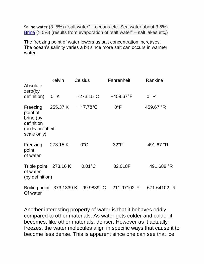
Saline water (3–5%) (“salt water” – oceans etc. Sea water about 3.5%)
Brine (> 5%) (results from evaporation of “salt water” – salt lakes etc,)
The freezing point of water lowers as salt concentration increases. The ocean’s salinity varies a bit since more salt can occurs in warmer water.
Kelvin Celsius Fahrenheit Rankine Absolute zero(by definition) 0° K -273.15°C −459.67°F 0 °R Freezing 255.37 K −17.78°C 0°F 459.67 °R point of brine (by definition (on Fahrenheit scale only) Freezing 273.15 K 0°C 32°F 491.67 °R point of water Triple point 273.16 K 0.01°C 32.018F 491.688 °R of water (by definition) Boiling point 373.1339 K 99.9839 °C 211.97102°F 671.64102 °R Of water
Another interesting property of water is that it behaves oddly compared to other materials. As water gets colder and colder it becomes, like other materials, denser. However as it actually freezes, the water molecules align in specific ways that cause it to become less dense. This is apparent since one can see that ice

floats on water, indicating it is less dense than the water and hence buoyant. We will talk more about this an buoyancy in general later. In dealing with temperatures, we can see that there are many different scales possible. Fahrenheit is one, Celsius is another. Kelvin is yet another that uses absolute zero as a starting point and the Rankin scale does the same. The difference between these two is the size of the degree. Kelvin uses the larger Celsius degree, which is 1.8 times larger than the Fahrenheit degree. WHY ARE DEFINITIONS IMPORTANT IN SCIENCE? DEFINITIONS Definition is an important part of science and one of the first things scientists need to do is to define their terms. Typically there are three kinds of definition or meanings: Usage Usage definitions which are the ones found in the dictionary and talk about the way people use the word. Frequently a good dictionary will give many examples of how the word has been used. Denotational Many words have denotational meanings – those which say what the word refers to. Connotational In many cases words have connotational meanings. These give some indication of what the person’s feelings are toward the referent. Countries change names sometimes because of connotational meanings. The two words may refer to the same piece of real estate but the connotations are different.

Emotional This is when the referential aspect of the word largely disappears and the word is used solely to express a strong emotion. In different cultures (languages) the “swear” words are often in completely different areas of the semantic domains. Some languages like English lean towards words that have to do with excrement and sex. Other cultures tend to supernatural things or plants and vegetables or some animals (which English does too). Chinese uses sex in verbal abuse; Japanese does not. Another is an scientific definition which is a specialized definition used by scientists which restricts meaning to a very particular meaning and tries to lose the connotational meanings associated with usage definition The problems here are that scientific definitions may be completely opposite of the usage ones. For example “myth” often means something which is untrue (That is just a myth). Technically, for folklorists and anthropologists a myth is a story believed to be true and sacred. So when an anthropologist says “The Bible is a myth” it means it is a story taken to be true and sacred, not that it is untrue. Similarly, the word “theory” technically means an explanation for something that has been repeatedly tested and no contradictions have been found. It is miles away from being a hunch or wild guess as it is sometimes used in usage. At the museum of American Museum of Natural History there is a model of a blue whale which the signage indicates is the biggest animal that ever lived. There is also a Titanosaur – a kind of dinosaur – where the signage proclaims that this is the biggest animal that ever lived. What is the problem?

(a) The whale sign went up before the titansaur was discovered so the “biggest animal” has changed
(b) “Big” is not technically defined. Does it mean “longest”? The Blue whales get to be 110 feet or so. The Titanosaur measures some 121 feet. Titanosaur wins.
(c) “Big” is not technically defined. Does it mean “body mass”? The titanosaur has a very long skinny neck and a very long skinny tail. The Blue Whale has nothing skinny. Which has the greater body mass? Who wins this time?
CONCEPTIONS TIME. TIMES - OF VARIOUS SORTS Time and tide wait for no man. Interestingly enough both words have the same origin. Time comes in many forms. Not only are there cultures that operate on different calendars (solar and lunar) but also the idea of time is quite different before and after the invention of the clock or chronometer. People tend to think in terms of their own life spans. Many scientists see things in geological time which is much longer and virtually incomprehensible to people.
There are many kinds of time scales and ways to measure it. Human time frame is usually measured in seconds, minutes, hours, days, years and decades and occasionally centuries and millennia. Sometimes the word “generations” is used to refer to a period of about 20 to 25 years Geological time on the other hand is much greater. It is not unusual to talk of millions of years. Time is divided into eons, eras, periods, epochs and ages. So what sometime seems like a long long time on a human time frame may just be a blip on a geological time frame.

(Precambrian time)
(geological ages) When we think of the history of the earth as being reduced to a single 24 hour period, humans appear only in the last minute.

(geological 24 hour clock)
HOW DOES THE CHANGING EARTH HAVE AN IMPACT ON LIFE FORMS – ESPECIALLY HUMAN MIGRATIONS So when the earth seems unchanging, it is only when we think in human terms not geological ones. The oceans are changing just as much as the land is. Many events that happen on the land, also happen under the ocean and have huge impacts on the rest of the world.

Movement of the tectonic plates under the ocean has caused many changes in the earth’s surface. In some cases, a major blockage of land has appeared and separated a single area of the sea into 2 separate parts as happens in Latin America. This has much importance in the evolution in some animals who having one species and breeding community finds itself with 2 which may know head off into different evolutionary directions. In addition the Earth has undergone a number of “ice ages” during which time the polar caps expanded and glaciers moved further and further south. As they move south, the push material in front of them. When they reach their southernmost point and start to retreat as the world heats up, they leave behind a terminal moraine – a large pile of material they pushed before them. The glacier came as far south as NY on the east coast and the terminal moraine is Eastern Parkway. The ice came even further south in the center of the country. As the glacier forms the water to make it up comes from the ocean. So as the glacier comes down from the north, the sea levels drop as well. Migrations have been hindered and facilitated by appearance of the ice ages. As the glaciers descend from the north and the tops of mountains, they require water to form the ice. This water is water that has ultimately come from the ocean. So as the glaciers descend, the sea levels also lower. As the sea levels lower, the shore line recedes and more and more land appears.

(ice age (last) - extent of ice1)
(ice age (last) - extent of ice2)

The area between Southeast Asia and Australia and New Guinea drops in sea level and many islands appear as land is uncovered. About 50,000 years ago, people made their way across this area into Australia and New Guinea and began to populate the Pacific. It would be many more years before the other Pacific Islands much further out in the ocean would become populated.
(human migration1)
The area between N. America and Asia is now separated by a short stretch of water known as the Bering Strait – a stretch of ocean about 55 miles across. However, in the strait there are islands so traveling from Asia to the Americas by this route is, even today, possible without being out of sight of land. Between Russia and the US the distance is about 2.5 miles. So you can actually see Russia from Alaska!

(Bering strait)
This is the path believed to be the one by which the original colonizers of N. American arrived, although there was at one point a land mass there called Beringia

(Beringia) Movement across the continent from East to West was probably slow. Interestingly enough, the earliest sites are found in S. America, leading to the idea that the migrations may have been along the coast line, which at the time, would have been much further out. Hence early sites in N. America would now be submerged. The S. American sites however are on ranges high above the water. So, sites there would not have been covered by rising water levels as they were in the north. Monte Verde is an archaeological site in southern Chile, located near Puerto Montt, Southern Chile, which has been dated to as early as 18,500 BP (16,500 B.C.).
Although there are many theories about the populating of the Americas which postulate early arrivals from many places, the archaeological and genetic data basically deny those claims.

The populating of the Pacific is the last major population movement into un occupied territory, although the Vikings also moved into an unoccupied Iceland.
(PolynesiaMigrations2)
The earliest movement into the Pacific has already been mentioned – that is the one to Australia and New Guinea.

(peopling of pacific) The populating of the rest of the Pacific Islands occurs over centuries.

(PolynesiaMigrations) Some years ago Thor Heyerdahl thought that people had populated the Pacific from the New World, rather than Asia. To prove his theory, he constructed a raft called “Kon Tiki”

with which he proceeded to sail from South America to French Polynesia

The raft ran aground on a reef in French Polynesia, but Heyerdahl proved it could be done. Many however pointed out that because something could be done, it did not necessarily mean it had been done. Recent DNA testing done on Pacific peoples has failed to show any genetic markers associated with Native American populations, but shows affiliations with Asian ones. This is somewhat odd since Native American populations contain many of the Asian markers.
SOME MIGRATIONS, LIKE THOSE IN THE PACIFIC ARE LESS AFFECTED BY THE GEOLOGICAL CHANGES. THE MIGRATIONS IN THE PACIFIC INDICATE A GROWING ABILITY TO TRAVEL ON VAST EXPANSES OF WATER AND THE DEVELOPMENT OF A SYSTEM OF NAVIGATION The movement of peoples across expanses of water requires some sort of convenience – a raft or a boat. Swimming is possible for reasonably short distances but not really a form used for migration. Boats and rafts differ in that rafts float because the material they are made of floats without any modification. Boats require displacement.

When any object (boat) displaces a weight of water equal to its own weight, it floats.

HOW TO GET AROUND THE OCEAN: NAVIGATION Many people who live near the ocean may venture out onto it on rafts or boats. However, the question of getting around on the water is difficult since there are no “LANDmarks” or “SEAmarks”.
Some peoples rarely go out of the sight of land and so in that case land marks can be used. However open ocean travelling requires something more complicated to get around. The distances involved in navigating the Pacific are far too great to use any kind of land marks. So there has to be another way of getting around. Pacific peoples used several methods for knowing where they were. One of these is astronomical. So here is some astronomy.

The stars are one possible guide to finding one’s direction. We all know the sun rises in the east and sets in the west, except it doesn’t. First of all the sun APPEARS to rise in the east and set in the west. It is not the sun that is moving, but the earth that is rotating. Secondly, the sun does not rise in the east – at least not due east, except twice a year – once on or about March 21 and once on or about Sept. 21. These are the dates of the vernal and autumnal equinoxes. After March 21, the sun “rises” and “sets” further and further north each day until about June 21 (the summer solstice and the longest day of the year). After that is starts to set further and further south each day. One Sept 21 it rises due east and there are 12 hours of daylight and 12 hours of darkness. From the autumnal equinox on, the sun continues to move further south until Dec. 21 – the winter solstice and the shortest day of the year). It appears in roughly the same position for about 3 days and then starts the journey north again.
So while the sun more or less rises in the east and sets in the west, it is only a general direction. Some peoples in the world

have 4 directions – NSEW while others have a different 4 - NE, SE, NW, SW. These are the four points that mark the extreme positions of the suns rising and setting. The “Tropic of Cancer” is the furthest point north of the equator where the sun can appear directly overhead. The “Tropic of Capricorn” is the same in the southern hemisphere. The dates on which this happens are the solstices. It happens at the equator on the equinoxes. The reason for all of this is that the earth is tilted at about 23.5 degrees to the earth’s path around the sun. This is what gives us “seasons”, and explains why the northern hemisphere has winter when the southern hemisphere has summer and vice versa.

How the stars appear to rise and set varies with ones LATITUDE The stars rotate around a “fixed” position which is marked in the

sky by the “North Star” called Polaris. At the North Pole, Polaris would be directly overhear. On the equator it would be on the horizon. So at the North Pole, stars do not rise and set, but circle around the sky. None rise and set. At the equator ALL stars except Polaris rise and set. Between the two extremes, some rise and set and some do not. Those that do not are called circumpolar stars. Since the Polaris is directly overhead at the North Pole, and directly on the equator on the equator, then one can tell ones latitude in the northern hemisphere by measuring the number of degrees Polaris is above the horizon. So Latitude is measured in degrees from the equator (0 degrees) to the North Pole (90 degrees North Latitude) or to the South Pole (90 degrees South Latitude). New York is about 40° 45.102' N latitude. (You must ALWAYS indicate N or S latitude!) When one travels south of the equator, Polaris disappears below the horizon. There is no nicely placed star over the South Pole the way Polaris is so a different method needs to be used there.