learning - cmsdata.iucn.org · listening, learning and adapting. but we must not do this in...
TRANSCRIPT

The IUCN Forest Conservation Programme 2008
Learning from Landscapes
arborvitaespecial
This arborvitae special reviews best practices in assessing landscape values. It is based upon on-the-ground experiences of the Ecoagriculture Partners Landscape Measures Initiative and IUCN’s Livelihoods and Landscapes Initiative.

Conservation organisations have been attempting to improve local peoples’ livelihoods whilst at the same time conserving the natural environment for several decades. Many features of landscape approaches discussed in this arborvitae special are unchanged from earlier integrated rural development, integrated conservation and development and ecosystem approaches to solving complex rural problems. The success rate of all of these ‘integrated’ approaches has however been the subject of much debate. The problem has been that the proponents of achieving the dual objectives of conserving nature and improving livelihoods rarely established ways of measuring the progress that they were making. The critical question is whether there are fundamental fl aws in the concepts underlying integrated approaches or whether it is simply that we have failed to work out how to measure our success.
Our central argument in this arborvitae is that landscapes are shaped by the decisions of multiple stakeholders. Improving landscapes requires infl uencing the behaviour of these stakeholders. This can rarely be achieved without social agreement on rules and regulations and how they are enforced. We need to build a social movement that has shared landscape values. Shaping landscapes is more a process of negotiation than of planning. And measuring success fi rst requires some shared understanding amongst stakeholders of what ‘success’ looks like. We will argue that investing in development of shared scenarios for the future of landscapes and in putting into place broad-based participatory approaches to measuring outcomes at the landscape scale is fundamental to success.
Landscapes are constantly evolving under all sorts of outside pressures – climate change, infrastructure development, ecological successions and economic pressures. The aspirations of the people who infl uence landscapes also change. So there can be no fi xed target or end-point to guide conservation practitioners. We have to be constantly experimenting, listening, learning and adapting. But we must not do this in isolation from the stakeholders – these have to be shared processes in which everyone involved is learning and adapting. Establishing a shared framework for measuring change can be a powerful tool in facilitating this shared learning and adaptation.
The vision of the landscape approach that we will present in this arborvitae is therefore one of social learning at the scale of landscapes. It is a process in which all those concerned attempt to learn and adapt together to achieve outcomes that are better for nature and people. We acknowledge that this is a diffi cult challenge – we are being somewhat idealistic. In reality not all stakeholders will ever share the same vision of a desirable future. So in real life it is a question of constantly ‘muddling through’ and trying to get the best deal that we can. The ideas that we present here are based upon our experience in tropical developing countries and are mainly intended for application in situations where poor people live in close proximity to sites of global biodiversity value.
2 news AV36 July 2008
The Challenge of Assessing Progress of Landscape Initiatives
2 AV SPECIAL: learning from landscapes
Jeff Sayer and Stewart Maginnis from IUCN with Louise Buck from Cornell University and Ecoagriculture Partners (EP)
and Sara Scherr from EP introduce this arborvitae special on
assessing the impact of ‘landscape approaches’ to reconcile
conservation and development interests.
Contents2 Assessing progress in landscape initiatives J Sayer, S Maginnis,
L Buck and S Scherr
3 What is the landscape approach? J Sayer and N Dudley
4 The ‘Lally Principles’ J Sayer, L Buck
and S Scherr
5 The ‘20 Questions’ checklist Ecoagriculture Partners
6-7 Monitoring biodiversity conservation outcomes
J Milder
8-9 Baseline photography and participatory drawing
I Boedhihartono
and E Barrow
10-11 Simulation models to monitor change M Sandker
and B Campbell
12 Participatory monitoring in the Tri-National de la Sangha
D Endamana
and A Eyebe
13 Using best practice in Ghana and Indonesia
IUCN
14-15 The ‘Sangha Guidelines’ for the landscape approach16 Next steps in monitoring landscape approaches
J Sayer, L Buck and
N Dudley

AV SPECIAL: learning from landscapes 3
What is a Landscape Approach?
Developed country resource managers with strong institutions, plenty of knowledge and an ability to enforce agreements see the landscape approach as a technical challenge where experts design an optimal landscape. People working in developing countries with weak institutions, a poor knowledge base and challenges to enforcing agreements see landscape approaches as more of a social challenge. These parallel schools of thought contain differences both in how decisions are made and how the landscape is divided. All may have their merits in the right situation.
How decisions are made:• Expert planning: Landscape-scale
interventions consist of the preparation of landscape plans based upon expert studies of production potential and conservation needs. Studies produce maps of an ideal potential landscape and often rely on legal instruments or land purchase to impose plans that are assumed to remain unchanged for a long period.
• Building constituencies, negotiating deals and muddling through: This school of thought recognizes that creating designer landscapes in places with weak institutions is extremely diffi cult. Market forces and differences in power and infl uence lead to situations where logical and rational changes in land cover are almost impossible to achieve. Here outside interventions have tried to engage with stakeholders and seek ways of infl uencing peoples’ behaviour to achieve a balance between development and environmental outcomes. The ultimate goals have to be set in general terms and the goal posts will constantly move. ‘Grand design’ has to give way to incremental planning and negotiation, or put simply ‘muddling through’. Drawing maps and building barriers has to give way to persuasion, building alliances and seeking infl uence.
In practice a mixture of the two is often attempted. The emphasis is also likely to change over time. As societies become less directly dependent on natural resources the time people are interested in devoting to negotiating management tends to decrease
and the role of centralised planning may increase. Conversely at times of increasing shortage people may demand greater involvement once again
How landscapes are divided:• Specialised uses: Areas of land and water
are precisely defi ned into specialised uses, e.g. protected areas, production areas, buffer zones, settlements, that segregate production areas from conservation areas and provide for linkages through corridors, riparian zones etc.
• Multi-functional landscapes: This approach recognizes that production areas yield environmental benefi ts and conservation areas may be subject to some extractive use. At an extreme, all land is seen as having a multifunctional approach. Where this school of thought is most developed – in Europe – it depends heavily on environmental service payments to farmers. Multi-functional landscapes are also associated with some community conserved areas, which have multiple functions throughout.
• Mixed landscapes: A halfway stage where some lands are more-or-less narrowly aimed at particular values (e.g. plantations, strict nature reserves) and others are recognised as having multiple values (e.g. extensive agricultural and grazing lands, IUCN Category V and VI protected areas).
These various landscape approaches all provide different challenges to those wishing to monitor and evaluate external interventions. There is progressively more complexity, uncertainty of goals and unpredictability of causal relations as one moves from the expert planning to negotiated approaches.
In the developing world, landscape scale interventions need to be fl exible and locally adapted. They tend to invest a lot in getting stakeholders to agree on measurable and monitorable outcomes. Discussions of change become the core of the process and these discussions are expected to lead to changes in the behaviour of stakeholders and thus to more sustainable outcomes.
The recent surge in commodity crop prices; realization of the harmful environmental impacts of the expansion of biofuels; and climate change are all examples of externally imposed changes that will render many fi rst and second generation landscape ‘plans’ redundant. These external changes reinforce our conviction that working ‘within the system’ and muddling through are often the only way forward.
The following pages explore a range of experiences from developing countries. None of them provides a silver bullet but perhaps they can inspire conservationists to fi nd the approach that works best for ‘their landscape’.
The term ‘landscape approach’ is used in different ways by different people, here
Jeff Sayer and Nigel Dudley provide some clarity on processes and terminology.
The LMRC is an online clearing house of
information and tools for stakeholders
working in landscapes where farming,
nature conservation and livelihood security
are being pursued.
The LMRC links elements of the landscape
assessment process to a variety of tools
and resources that allow local stakeholders
and their supporters to collaborate with one
another and with external stakeholders in
measuring the fl ows of environmental and
developmental benefi ts from landscapes.
Case studies illustrate the contexts in
which LMRC may be a helpful resource and
highlight the use of particular tools.
A glossary of key terms is also provided.
The LMRC is a product of the Landscape
Measures Initiative (LMI) which is
coordinated by Ecoagriculture Partners.
The LMI engages some 25 organizations,
worldwide, in identifying and fi eld testing
practical indicators for multifunctional
landscapes. The LMRC has been
designed as an interactive tool – users are
encouraged to give feedback and can
participate in an online discussion forum.
Visit the LMRC site at:
www.landscapemeasures.org.
Landscape Measures Resource Center (LMRC)

The ‘Lally Principles’
A team of landscape practitioners from IUCN, EP and Cornell University met at an isolated chalet in the Swiss mountain village of Lally to debate how to better measure change in landscapes. We were concerned that the problem was not for us to assess other peoples’ landscapes but rather for us
to work with local stakeholders so that we could together learn about, and infl uence landscape change.
The resulting ‘Lally Principles’ constitute ideas about how organizations concerned with achieving conservation, production and
livelihood outcomes within a landscape level framework should manage the process of intervention and interaction.
The principles are given below and a fuller discussion of each principle can be found at: www.landscapemeasures.org
1. Use caution on entry. Initiatives must
ensure that local stakeholders are part of the
process, and that gender perspectives are
applied. Projects should not arrive with ready-
made solutions, but need to earn their seat
at the negotiating table by offering plausible
contributions to meeting the needs and
aspirations of local people.
2. Invest in skilled facilitation. Negotiating
desirable scenarios and effective measures of
progress towards their achievement requires
an inclusive, well-managed, transparent and
equitable facilitation process.
3. Share ownership of the process.
Ideally the process should be owned by
local stakeholders and institutions.
4. Understand institutional context.
Success requires an understanding of the
role of local institutions (i.e. formal resource
management and economic institutions,
informal customs and groupings and the
relationships between these institutions).
5. Focus on landscape functions.
It is easier to reach agreement with multi
stakeholder groups if negotiations focus on
landscape functions (i.e. fl ows of goods and
services).
6. Search for synergies. There is
usually some trade-off between production
(e.g. agriculture) and conservation. Win-win
situations are rare – a basic principle is to
seek scenarios where we can win more
and lose less.
7. Recognize different scales. The scale
of a landscape should be determined by
the landscape function or issue of concern;
it is better to focus problem-solving and
management at the over-arching problem
being addressed.
8. Begin small and expand. Begin the
process of negotiating and assessing
performance on a small scale and expand
progressively as one gains experience and
networks of collaborators – but never forget
the landscape-scale approach.
9. Understand landscape dynamics.
Use tools such as participatory mapping
and drawing (visualization), historical context
analysis and digital elevation models to build
an understanding of what infl uences the
landscape.
10. Explore scenarios fully. Reach
agreement amongst stakeholders on what an
improved state of the landscape would look
like. Visualization can again be valuable, with
participants drawing desirable and undesirable
outcomes.
11. Select aims and indicators carefully.
Negotiate aims and a small number of easily
measurable indicators of desirable future states
of the landscape (i.e., outcome indicators).
Indicators should be effective in detecting
changes in the landscape and are considered
important by stakeholders.
12. Choose comprehensive indicator sets.
Indicators should cover four areas
• Biodiversity values and ecological functions
• The productivity of agricultural and natural
resource systems
• The livelihoods of the population
disaggregated by social groups, especially
those whose livelihoods are resource-
dependent
• Institutional arrangements for the
governance of the landscape, including
laws and customs, regulations, and norms
of behaviour
13. Make trade-offs explicit. Negotiations
of outcomes and measurement indicators will
be credible only if they recognize the trade-offs
that need to be addressed in the landscape.
14. Embed tracking measures in long-
term management arrangements.
Indicator sets and their measurement should
be revisited, updated and discussed with all
stakeholders.
15. Prevent high-tech tools from driving
the process. Remote sensing and GIS
techniques are excellent slaves but poor
masters.
16. Learn from failures. Just as confl icts
and trade-offs must be made explicit, similarly,
failures must be recognized and management
must respond to them.
17. Embrace change. Outcomes of
negotiation processes will be temporary, and
must be re-visited on an ongoing basis.
18: Identify stakeholders. Transparent
decisions are needed about how
geographically wide the group of involved
stakeholders is drawn from.
19: Be transparent about the
opportunities: inform all stakeholders about
what can and cannot be achieved by engaging
in the process.
A review of new principles to negotiate and measure outcomes with stakeholders developed by
Jeff Sayer, IUCN, Louise Buck, EP and Cornell University, Sara Scherr, EP and colleagues from
WWF and University of Utrecht
2 news AV36 July 20084 AV SPECIAL: learning from landscapes
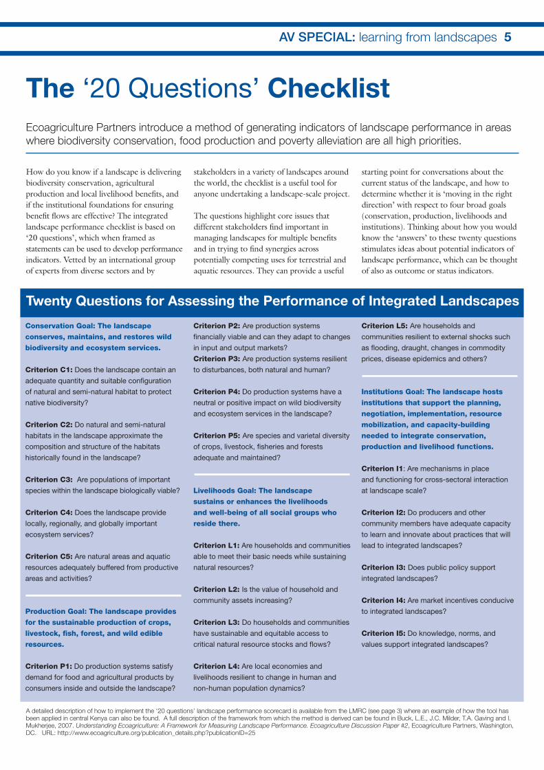
The ‘20 Questions’ ChecklistEcoagriculture Partners introduce a method of generating indicators of landscape performance in areas
where biodiversity conservation, food production and poverty alleviation are all high priorities.
AV SPECIAL: learning from landscapes 5
Conservation Goal: The landscape
conserves, maintains, and restores wild
biodiversity and ecosystem services.
Criterion C1: Does the landscape contain an
adequate quantity and suitable confi guration
of natural and semi-natural habitat to protect
native biodiversity?
Criterion C2: Do natural and semi-natural
habitats in the landscape approximate the
composition and structure of the habitats
historically found in the landscape?
Criterion C3: Are populations of important
species within the landscape biologically viable?
Criterion C4: Does the landscape provide
locally, regionally, and globally important
ecosystem services?
Criterion C5: Are natural areas and aquatic
resources adequately buffered from productive
areas and activities?
Production Goal: The landscape provides
for the sustainable production of crops,
livestock, fi sh, forest, and wild edible
resources.
Criterion P1: Do production systems satisfy
demand for food and agricultural products by
consumers inside and outside the landscape?
Criterion P2: Are production systems
fi nancially viable and can they adapt to changes
in input and output markets?
Criterion P3: Are production systems resilient
to disturbances, both natural and human?
Criterion P4: Do production systems have a
neutral or positive impact on wild biodiversity
and ecosystem services in the landscape?
Criterion P5: Are species and varietal diversity
of crops, livestock, fi sheries and forests
adequate and maintained?
Livelihoods Goal: The landscape
sustains or enhances the livelihoods
and well-being of all social groups who
reside there.
Criterion L1: Are households and communities
able to meet their basic needs while sustaining
natural resources?
Criterion L2: Is the value of household and
community assets increasing?
Criterion L3: Do households and communities
have sustainable and equitable access to
critical natural resource stocks and fl ows?
Criterion L4: Are local economies and
livelihoods resilient to change in human and
non-human population dynamics?
Criterion L5: Are households and
communities resilient to external shocks such
as fl ooding, draught, changes in commodity
prices, disease epidemics and others?
Institutions Goal: The landscape hosts
institutions that support the planning,
negotiation, implementation, resource
mobilization, and capacity-building
needed to integrate conservation,
production and livelihood functions.
Criterion I1: Are mechanisms in place
and functioning for cross-sectoral interaction
at landscape scale?
Criterion I2: Do producers and other
community members have adequate capacity
to learn and innovate about practices that will
lead to integrated landscapes?
Criterion I3: Does public policy support
integrated landscapes?
Criterion I4: Are market incentives conducive
to integrated landscapes?
Criterion I5: Do knowledge, norms, and
values support integrated landscapes?
How do you know if a landscape is delivering biodiversity conservation, agricultural production and local livelihood benefi ts, and if the institutional foundations for ensuring benefi t fl ows are effective? The integrated landscape performance checklist is based on ‘20 questions’, which when framed as statements can be used to develop performance indicators. Vetted by an international group of experts from diverse sectors and by
stakeholders in a variety of landscapes around the world, the checklist is a useful tool for anyone undertaking a landscape-scale project.
The questions highlight core issues that different stakeholders fi nd important in managing landscapes for multiple benefi ts and in trying to fi nd synergies across potentially competing uses for terrestrial and aquatic resources. They can provide a useful
starting point for conversations about the current status of the landscape, and how to determine whether it is ‘moving in the right direction’ with respect to four broad goals (conservation, production, livelihoods and institutions). Thinking about how you would know the ‘answers’ to these twenty questions stimulates ideas about potential indicators of landscape performance, which can be thought of also as outcome or status indicators.
Twenty Questions for Assessing the Performance of Integrated Landscapes
A detailed description of how to implement the ‘20 questions’ landscape performance scorecard is available from the LMRC (see page 3) where an example of how the tool has been applied in central Kenya can also be found. A full description of the framework from which the method is derived can be found in Buck, L.E., J.C. Milder, T.A. Gaving and I. Mukherjee, 2007. Understanding Ecoagriculture: A Framework for Measuring Landscape Performance. Ecoagriculture Discussion Paper #2, Ecoagriculture Partners, Washington, DC. URL: http://www.ecoagriculture.org/publication_details.php?publicationID=25

Outcome monitoring – from concept to practiceConservation of wild biodiversity is a central goal of approaches to integrated landscape management. Conceptually, it is simple to evaluate and monitor the contribution of managed landscapes to wild biodiversity conservation: one need only quantify the diversity, abundance, and distribution of organisms and habitats on the landscape. Operationally, however, such monitoring has proven extremely diffi cult, especially in the agricultural mosaic landscapes that characterize smallholder agriculture throughout major portions of the developing world. Practitioners face several important challenges:
Challenge 1: The fi ne-grained nature of agricultural mosaic landscapes means that it is diffi cult to generalize from one location
to the next, or to establish a valid sampling system from which to draw conclusions about the landscape as a whole.
Challenge 2: Agricultural mosaics, especially in a smallholder context, tend to be quite dynamic due to shifting human management regimes. As a result, these landscapes may be in a state of permanent ecological disequilibrium whereby species assemblages are not fully characteristic of their habitat or ecological context, and where historical legacies exert strong infl uences.
Challenge 3: Landscape context is likely to have a high, but variable, infl uence on species distribution, so site-scale characteristics may not be a good predictor of plant and animal assemblages.
Challenge 4: Data availability and access are often quite limited. Fragmented plot ownership in smallholder landscapes means that fi eld data collection requires coordination with numerous private landowners. In developing countries, baseline data are typically absent, GIS databases are sparse or nonexistent, and large areas may be physically inaccessible for fi eld work.
In light of these challenges, an initiative is in process to identify pragmatic approaches to biodiversity monitoring in mosaic landscapes by evaluating the accuracy and cost-effectiveness of several potential methods, both established and novel. First, we are investigating the validity of various proxies for biodiversity conservation outcomes that could be used to garner conservation data for large areas and to integrate across disparate landscape patch types (Challenge 1). Second, we are working to determine the most appropriate scale or scales at which to monitor conservation outcomes (Challenge 3). Finally, we are evaluating the tradeoffs between data accuracy and the cost of data acquisition to identify the ‘minimum data set’ necessary for valid conservation outcomes assessment, and to determine how additional monitoring resources can be used most strategically to improve data quality (Challenge 4).
Conceptually, different approaches to biodiversity monitoring can be arrayed along a continuum from the most accurate (but most expensive) techniques to those that are the most affordable (but least accurate). Figure 1 shows the approximate location along this spectrum of the fi ve approaches that are included in this project. All of these techniques have been used in the context of agricultural mosaic landscapes, and some have been evaluated for accuracy. However, no prior studies have explicitly compared all of these approaches to assess their relative accuracy or cost-effectiveness in particular locations.
In addition, almost all prior studies on biodiversity assessment in agricultural
Monitoring Biodiversity Conservation Outcomes in Complex Agricultural Mosaic Landscapes
Jeffrey C. Milder, EPartners and Cornell University, investigates
possibilities for cost-effective outcome monitoring.
Esparza landscape in Costa Rica
Jeff
Mild
er
2 news AV36 July 20086 AV SPECIAL: learning from landscapes

mosaics have been limited to individual landscapes. Such studies can elucidate relationships between agricultural management and conservation outcomes in specifi c contexts (particular bioclimatic zones, cropping systems, and so forth) but cannot determine whether there are consistent relationships that hold true more generally. Establishing the consistency of these relationships is the sine qua non for identifying reliable proxies that can be used in new landscapes where detailed scientifi c studies have not yet been completed.
Practical, cost-effective biodiversity monitoring To assess the consistency of the relationships among the species composition, site-scale, and landscape-scale indicators shown in Figure 1, the project is working in four silvopastoral landscapes in northern Latin America. Silvopasturalism is an agroforestry technique that integrates livestock production with forest patches, tree cover, and small cropped areas in a fi ne-grained mosaic. It is a dominant land use practice throughout Mesoamerica, supporting many smallholder farmers and believed to be critical for sustaining biodiversity outside of protected areas. If consistent relationships and reliable proxies are identifi ed across the four landscapes, these may be applied to other silvopastoral systems throughout the region.
One of the key outcomes of this effort is to identify a range of cost-effective biodiversity monitoring approaches for agricultural landscape mosaics. To do this the project is fi eld testing monitoring in line with the continuum of approaches outlined in Figure 1. The research aims to identify pragmatic approaches to biodiversity monitoring in mosaic landscapes by evaluating the
accuracy and cost-effectiveness of several potential methods, both established and novel. At one end of the spectrum, there is the ‘gold standard’ approach that combines fi eld surveys and remote sensing. This approach may be suitable for scientifi c research efforts or learning-based pilot projects sponsored by national governments, NGOs, or multi-lateral organizations. At the other end of the spectrum, there are low-cost techniques to track changes in the biodiversity conservation outcomes of agricultural landscapes. These rely heavily on remote sensing data, including the very
low cost ASTER imagery. There are numerous possible applications for low-cost techniques, including in conservation and rural development projects, for monitoring conservation benefi ts in payment for ecosystem services programs, and for guiding community-based conservation efforts, such as those now ongoing in the Copan and Matiguas landscapes.
Detailed descriptions of the fi ve approaches to biodiversity monitoring being explored in the Esparza landscape, Costa Rica can be found via the LMRC website.
AV SPECIAL: learning from landscapes 7
Figure 1.
Different approaches to
biodiversity monitoring
in agricultural mosaic
landscapes being
investigated in this project.
A scorecard has been designed and tested that can aid leaders of a multi-stakeholder
landscape initiative in assessing the capacity and the potential for the institutional
environment to foster an integrative approach to planning and management. The
institutional scoring tool is based on the premise that how the institutional environment
performs will be an important predictor of how the landscape performs in delivering
conservation, production and livelihood outcomes. It is designed around the theory that
the institutional environment for landscape planning and management is likely to be most
effective when a combination of public, private and civic organizations are present in
the landscape; when these organizations have adequate fi nancial and human capacity
to operationalize their mandates; and when they are willing and able to coordinate their
policies and activities.
The institutional scorecard exercise consists of three parts. The fi rst involves identifying
the specifi c organizations that have a presence or infl uence in the landscape. The second
involves engaging people who are knowledgeable about the institutional environment
in the area in scoring the relevant attributes of these organizations. Part three engages
participants in thinking about the fi ndings and discussing what they mean for their
landscape.
Instructions and examples for using the Institutional Performance Scorecard can be found
at the LMRC website: www.landscapemeasures.org
Louise Buck, and Debra Rich, Cornell University and EP
Scoring Institutional Performance in Integrated Landscapes
fi eld assessment of
animal diversity
fi eld assessment of
vegetation composition
and structure
fi eld assessment of land
cover for plot-level analysis
land cover classifi cation of high-
resolution satellite imagery (<– 1m)
for landscape analysis
GIS analysis of medium-
resolution satellite imagery
(15m) for landscape analysis
Less accurate Lower cost
More accurate Higher cost

The Mount Elgon landscapeThe slopes of Mount Elgon in Uganda are densely settled, the population is increasing and land is scarce. The Mount Elgon National Park which protects the montane forests and upland heaths on the mountain is considered of national importance for its watershed protection values and its biodiversity. For over 50 years the Ugandan authorities have been seeking to fi nd a compromise between the local peoples’ need for land and the imperative of protecting the mountain.
Conservation and development activities have included boundary demarcation with strips of trees, introduction of agroforestry and livestock to increase incomes of local people, some limited ecotourism activities and a lot of law enforcement. The boundaries of the protected area have been adjusted on two occasions to provide more land for the people but these boundaries are still contested.
Baseline photographyIUCN advisers have worked in the area for almost 20 years – but the advisers change every few years and it is now diffi cult for people to recall the exact situation at the beginning of the project. Several donors have supported the project and all imposed their own monitoring and evaluation systems but much of this information is now lost or diffi cult to locate, and what does exist tends to relate to what the projects delivered and not to the outcomes on the ground. Maps were drawn and photographs must have been taken but they provide little evidence of change.
When the IUCN/Ecoagriculture Partners team visited the area in March 2007 it was therefore decided that recording a rigorous baseline was a high priority. Photographs were taken from key vantage points showing both the state of the landscape and the way of life of the people.
Key points to remember when using baseline photography are: • For each photo record the geographic
coordinates of the point from which the photo is taken together with the direction of the photo and the date and time.
• Include prominent landscape features in the photo – geomorphologic features, large trees etc.
• Archive the photos in more than one location using a system that will endure staff changes, project completion etc.
Participatory drawing Conservation and development organizations make assumptions about the sort of landscape scale outcomes that stakeholders wish for. Biologists see protected forests, corridors, riparian strips of vegetation etc. Villagers see arable land, land tenure rights, fuel and fruit trees, water supplies etc. IUCN has found that one of
Baseline Photography and Participatory Drawing in East Africa
Intu Boedhihartono and Ed Barrow, IUCN, discuss a new approach to landscape planning.
2 news AV36 July 20088 AV SPECIAL: learning from landscapes
Drawing the future desired landscape of Mount Elgon area
Intu
Bo
edhi
hart
ono

the most effective ways of engaging in a discussion about desired outcomes with local stakeholders is to allow them to draw maps expressing their understanding of the landscape and their wishes for the future.
Some lessons learnt from this process include: • Listen, learn and observe: Get to
know the people fi rst ‘hang out’ in the village, take part in ceremonies or sporting events, visit farmers’ fi elds, take an interest in the activities of the women and children
• Let people simply express themselves: In general give as few prompts as possible when asking people to draw landscapes, the process is often slow to start but then debates fl are up amongst participants and a lot of information starts to be presented.
• Provide advice on scale: If people choose their own scale they will generally just restrict themselves to their immediate surroundings – their own land, water and fuel wood sources etc. To get an idea of how they see and use the broader landscape it is better to provide reference points, usually using a scale of either 1:50,000 or 1:100,000.
• Discussions are often more valuable than the drawings themselves: The process usually leads to debates; the extent to which project coordinators take part in these debates and provide prompts depends upon the specifi c objectives.
• Different groups should develop different maps: Sometimes a cross section of a community can draw a single map, but in many situations it is advisable to get men and women to work separately, and to ask different ethnic or interest groups to draw separate maps. Thus in Sudan nomadic pastoralists draw independently of sedentary farmers, and in Central Africa pygmies have drawn maps independently from their Bantu neighbours.
• Compare landscape visions: Field workers can be used to collect maps from samples of stakeholders using standardized approaches so that the mapped elements can be scored and the scores of different stakeholders statistically analyzed. This technique has been used,
for example, to demonstrate the different appreciations of ‘forest’ between Pygmy and Bantu groups, or between ‘Government offi cials’ and local people.
• Archive and digitise the maps: When the drawings are complete photograph them for the project archives. Photographs can also be manipulated using software such as photo-shop, paintbrush etc. Animated
photographs can be used as negotiating support tools, e.g., the number of trees can be increased or decreased, boundaries can be moved, land rights can be represented. This requires skill in the use of the software and some artistic talent. The fi nal agreed ‘vision’ for the landscape can then be laminated and given to the people to be displayed prominently and used to monitor progress.
AV SPECIAL: learning from landscapes 9
Village drawings are digitized and manipulated electronically to be used in negotiating
and visioning exercises
Intu
Bo
edhi
hart
ono
Current Tuikat Landscape
Desired Tuikat Landscape

Landscape scale conservation and development projects can use simple simulation models to better understand processes of landscape change and particularly how local peoples’ livelihoods and landscape scale environmental benefi ts may change in the future. Understanding these changes is an essential basis for attempts to infl uence them.
A number of user friendly modelling software packages can be used for developing models. We used STELLA but SIMULE or VENSIM can also be used. All can be purchased over the internet. The models require quantitative data on land cover, benefi t fl ows to households and the nature and amount of environmental benefi ts. To get the models to run and to provide plausible simulations the data have to be reasonably accurate. Building a model therefore requires collecting fairly extensive baseline data on the features of the landscape that are of interest.
Malinau research forest, IndonesiaA model of the Malinau research forest in East Kalimantan has been built up by researchers from CIFOR together with partners from local government and NGOs. There has been considerable research on local livelihoods and forest values in the area so basic data were available. In addition government agencies had information and maps giving overall demographic and land cover data. Detailed information on household incomes and on forest management activities made the modelling easier; but some additional data collection was required.
By 2001 a basic model had been developed and its ability to simulate changes found to be realistic; this suggested that it was based upon reasonably accurate data and a correct diagnosis of the processes of change in the landscape. The model initially showed that fuel costs for transporting timber and minerals and the extent of potential investments in infrastructure and industrial tree crops were the major potential drivers of landscape
change. Over successive years other factors began to emerge as potential drivers of change. Government decentralization meant that more of the profi ts from resource extraction stayed in the area. Environmental concerns of the local administration led to restrictions on new investments and closure of a coal mine.
We were able to revisit the original model and both check its validity and update it to include new elements. For instance when plans were announced for major expansion of oil palm in the area it was fairly simple to adapt the model to determine the likely impacts of this on local livelihoods and on the extent of natural forest areas. We were also able to model the potential for environmental payments for Reduced Emissions from Deforestation and Degradation (REDD), which was raised as an issue in the area at the time of the Bali COP of the Climate Change Convention, given that this approach would exclude or limit palm oil investments while providing a carbon payment, to be divided between central government, district government and the local communities.
We used the model to explore the different future scenarios and their implications on forest cover and local communities’ incomes from oil palm investment and REDD. The simulations can tell us whether the REDD payments could make up for forgone incomes from oil palm jobs and IPK (timber clearing for plantation installation) jobs (see Figure). The model also included so-called multiplier effects where, for example, the increased salaries in the local economy had a boosting effect on trade and agriculture production while the forest conversion to oil palm is likely to decrease income from forest products.
The fi gure shows the benefi t fl ows to local communities in terms of cash income. The converters (circles), calculating the income from different activities are summed up in the flow (income in the fi gure) going into the stock total annual income for the local communities in Malinau. In this fi gure, only the income from REDD payments and oil palm investments are shown in detail, the dotted converters are calculated in more detail elsewhere in the model. The converter called ‘scenario REDD’ is a switch which determines whether the model is run assuming the
Simulation Models to Monitor Change
Marieke Sandker and Bruce Campbell of CIFOR discuss the use
of software models in landscape planning approaches.
2 news AV36 July 200810 AV SPECIAL: learning from landscapes In
tu B
oed
hiha
rto
no

REDD scenario or the oil palm investment scenario. When using the model, you can double click on the converters, to open a window to show the value of the converter which can be a calculation, a fi xed value or a changing value.
Lessons learned from modelling in Malinau• It is vitally important to fully document the
sources and probable accuracy of data put into the model.
• It is essential to carefully archive all versions of the model – we were tempted to incrementally modify the model so that no one was quite sure which parts contained the original 2001 data and which parts contained more recent fi gures.
• Model builders move on – it is important to archive the models in locations and ways that make them accessible and understandable to future users.
• The local administration developed some modelling skills and maintains copies of the models. This is an ideal situation as the administration will be there for ever. However civil servants change jobs and institutional memories can be short. Research organizations should maintain back-up copies of models.
Further reading, Sandker, M., A. Suwarno, and B. M. Campbell. 2007. Will forests remain in the face of oil palm expansion? Simulating change in Malinau, Indonesia. Ecology and Society 12(2):37. URL: http://www.ecologyandsociety.org/vol12/iss2/art37/.
AV SPECIAL: learning from landscapes 11
Video is a powerful communication tool that can convey situations, ideas and emotions
in ways that the written word cannot. The availability of relatively inexpensive video
equipment and the Internet as a distribution mechanism presents vast opportunities
for civic organizations to leverage the power of the moving visual image.
Landscape approaches to conservation present a number of challenges to
practitioners including the large spatial areas involved, the diversity of threats that
stakeholders face, and the inevitable confl icts that must be resolved. Such issues
are critical to convey to donors, community partners and researchers in order to give
them a realistic sense of the scope of the problems and the work that is being done
to address them. Videos can be a useful tool to help illustrate these challenges in a
succinct, effi cient and powerful way.
A good example of this approach is a video about ecoagriculture approaches to food
production, biodiversity conservation and livelihood security in Kenya. The video was
prepared through a partnership between KENVO (Kijabe Environmental Volunteers),
a community based organization that formed to arrest the destruction and degradation
of the Kikuyu Escarpment Forest, Ecoagriculture Partners and ConservationBridge.org
at Cornell University.
The key to the success of the Kijabe Landscape video was the collaborative approach
taken throughout the production. The main goal for the video was to help convey the
work that KENVO’s founder David Kuria is spearheading on behalf of residents in the
landscape, the challenges he is facing, and the solutions he is implementing. As such,
David was teamed up with a professional videographer and given control over the
content of the fi lm to ensure an accurate portrayal of the situation. This included giving
him control of whom to interview, how to interview them, and what shots were taken.
The video was posted on YouTube for distribution to various websites including the
LMRC and KENVO’s website. This distribution strategy has allowed the video to be
used in different contexts including university classroom settings. To view the 9 minute
video, visit: http://www.ecoagriculture.org/page.php?id=70&name=Video
R. Jamie Herring and Louise Buck, Cornell University and EP
Using Video as a Communication ToolFigure 1: Modelling the relationship between REDD
payments, income oil palm and timber clearing
Total annual income
local communities
Malinau SpendingIncome
Total income
forest products locals
Total income
agriculture locals
Total logging fees
paid to communities
Total income HPH
timber jobs to locals
Total income mining
jobs to localsTotal income
civil servant
jobs to locals
Total income
trade to locals
Total REDD payment
to local communities
Share of REDD for
local communities
Total REDD
payment
Carbon stock not
emmited
Carbon price
Scenario REDD
Total jobs in oilpalm
for local people
Oilpalm
salary
Total jobs in IPK forest
clearing for local people
Total income
oilpalm for local
people
IPK salary

The Tri-National de la Sangha (see map) is one of the priority landscapes whose conservation and development is supported by the Congo Basin Forest Partnership. The landscape includes the protected areas and production forests that come together where Congo, Cameroon and Central African Republic meet along the Sangha River. Several international conservation organizations and local NGOs and government agencies work in the area.
Since 2003 WWF, IUCN and CIFOR have collaborated to develop a shared monitoring system to track progress in the landscape. Initially a multi-stakeholder group was assembled and using participatory drawing, fl ash cards etc the group was helped to identify indicators that would tell the group if progress was being made towards a ‘better landscape’. Initially 30 indicators were selected. The group then agreed on how each indicator could be scored on a 1- 5 (Likert) scale.
The indicators represent 30 attributes that the participants agreed would be easy to measure and represent a good approximation of progress or lack thereof. Indicators included the populations of some conspicuous wildlife species, the effectiveness of local NGOs, perceptions of corruption, condition of infrastructure, availability of health care, schools and water supplies etc.
A multi-stakeholder group is convened each year to re-assess the indicators. The group always contains a majority of members from previous years but as people move on some renewal has occurred. Each year the discussions reveal a need to add or delete indicators
and revise the scoring system. However the changes are quite small and it is still possible to detect changes from year to year.
The indicators were all simple quantitative measures of things that all participants agreed were important in the landscape. Only a selection is presented here. The debates during which the scores are awarded each year are an important event at which people take stock of progress. External organizations have adapted their programmes to take account of the lessons learned from progress each year.
Lessons learned• Representative participation of all
stakeholder groups has been impossible to achieve. We have relied on a selection of people who can refl ect the points of view of each stakeholder group – this means mainly staff of local NGOs, the administration or international NGOs.
• External convening and facilitation of the process is necessary.
• The absolute fi gures obtained on the indicators are less important than the subjective opinions that they represent.
• Aid agencies who fund activities fi nd the approach too ‘touchy – feely’ they would prefer objective measurements by external consultants.
• People living and working in the area, especially those working for conservation organizations, fi nd the annual dialogue on progress has been useful and has opened up new thinking on what is needed to reconcile environmental and livelihood objectives for the area.
The full methodology is available in: Sayer, J.A., B. Campbell, L. Petheram, M. Aldrich, M. Ruiz-Perez, D. Endamana, Z. N’Zooh Dongmo, L. Defo, S. Mariki, N. Doggart and N. Burgess. 2007. Assessing environment and development outcomes in conservation landscapes. Biodiversity and Conservation16:2677–2694. DOI10.1007/s10531-006-9079-9. Springer Verlag.
Participatory Monitoring in the Tri-National de la SanghaDominique Endamana, WWF and Antoine Eyebe (USAID,
CARPE) report on a collaborative project in Cameroon, Congo
and Central African Republic
2 news AV36 July 200812 AV SPECIAL: learning from landscapes
Physical
capital
Human
capital
Global
natural
capital
Social
capital
Local natural capital
5
4
3
2
1
2007 2008
Figure 1: Map of the Tri-National de la Sangha
Figure 3: Summary of changes in capital assets in the Tri-National de la Sangha
Figure 2: Examples of indicators
Indicator 1: Progress in achieving certifi cation
Indicator 2: Number of elephants
Indicator 3: Perception of corruption
Cameroon CongoRCA
Cameroon CongoRCA
Cameroon CongoRCA Entire TNS
Entire TNS
Entire TNS

The agro-forests of Western GhanaThe forest landscape of Ghana is characterised by a gradual transition from the humid forest ecosystem to savannah scrub. IUCN is working in the southwest of the country, an area with landscapes composed of cocoa agro-forests, logging concessions and some forest reserves. The landscape is densely settled, mainly by migrants from other parts of Ghana attracted by the cocoa boom and by employment in the area’s gold mines. Several remnant forest patches in the area have been identifi ed as Globally Signifi cant Biodiversity Areas and have legal protection as a result.
The scale of the work is being determined by the traditional community organisations – the Stools, and we are working primarily with the chiefs of the Stools and
representatives of the communities that they represent. A number of landscape scale exercises have been conducted in the area including:
• Participatory visualization with local communities to explore scenarios for future changes in the landscape – it showed that intensifi cation of the cocoa production sector had the potential to ‘simplify’ the landscape. The diverse agro-forest systems that yield a wide range of subsistence and commercial crops (Cola, Allanblackia, bushmeat etc) are at risk. Intensifi cation could also lead to aggregation of land holdings in the hands of a few people and marginalisation of the majority.
• Simulation modelling of land-cover change. A simple model was built showing how different parts of the
landscape mosaic contributed to household incomes – baseline data was collected.
• A photographic baseline was assembled.• The PROFOR forest – poverty toolkit
was used to develop a poverty baseline
Projects in Papua Province, IndonesiaWamena Regency is located at a high elevation with a dense human population mainly dependent on cultivation of sweet potatoes, potatoes and yams. The Lorentz National Park World Heritage site forms the border of the settled area and is subject to encroachment and extraction of timber and non-timber products. Consequently, there are land confl icts between the national park’s authority and the local people.
Wamena is only accessible by air and this is placing severe constraints on development options. There are ambitious plans to build roads into the area, some of which would pass through the national park. If these roads are built signifi cant land-cover change is likely to occur. We therefore worked with IUCN partners in the area to:
• Develop a simple simulation model of potential land-cover change and of the impacts that different development scenarios might have on local incomes and on the integrity of the park.
• Visualization of scenarios for the area leading to the development of maps of tribal territories.
By contrast, the Bomerai and the Bird’s Neck area’s are low lying with a very sparse human population whose subsistence is based on harvesting of wild sago. The area is recognized as having very high biodiversity values. It is now threatened by road construction to open up the area for mining, estate crops (biofuels such as oil palm), logging and harvesting of mixed tropical hardwoods for pulp mills. In anticipation of these changes we have started the process of forming a multi-stakeholder forum to explore scenarios and identify indicators of good and bad land use change. This forum will attempt to bring together representatives of industry, government and the isolated local communities.
For more information: http://cms.iucn.org/about/work/programmes/forest/fp_our_work/fp_our_work_initiatives/fp_our_work _ll/index.cfm
Using Best Practice in Ghana and Indonesia
All the approaches and tools discussed in this arborvitae special are
being extensively used by IUCN’s Landscapes and Livelihoods programme. Below we include just a few examples of our work.
AV SPECIAL: learning from landscapes 13
Walaek-Baliem Valley, Papua Province, Indonesia
Intu
Bo
edhi
hart
ono

In June 2008, the group held a workshop at Bayanga in the Central African Republic where representatives from international NGOs and research centres, aid agencies, governments and local people debated the lessons learned from attempts to apply landscape approaches in the Congo Basin. Proposed guidelines from international processes and from the academic literature were reviewed and participants in the meeting voted on which were most relevant to the landscapes where they worked.
The voting process led the group to refi ne the long list of potential guidelines that were considered the key orientation for landscape scale interventions. Twenty-seven guidelines emerged from the process, framed around six Principles, and four Overarching Considerations of a landscape approach. The Sangha Guidelines will be used as a starting point for an international effort to develop more broadly applicable Guidelines for landscape approaches in other areas.
Principle 2: Stakeholder platforms are needed to enable governmental, non-governmental and civil society actors to negotiate and take decisions at a landscape scale.
Guidelines:5. Spatial plans must be developed and implemented
based upon analysis of the status and potential of the land and of the needs and wishes of the human population and balancing the importance of conservation and environmental service provision.
6. Landscape-scale interventions must be negotiated amongst all concerned stakeholders and neutral facilitation of this process is an important element of success – partnerships between actors with differing competencies and objectives will be essential.
7. No single formula exists for a landscape approach and the process will have to be adapted to take account of the specifi c conditions of the landscape and the objectives of the intervention.
8. Background studies of the physical, biological and human resources of the area are necessary and the participation of all actors in data collection and in subsequent monitoring is important in order to benefi t from local knowledge and to secure local ownership of the process.
9. A good understanding the processes that are causing change in the landscape is important. This can form the basis for the exploration of possible future scenarios and for the development of a shared vision amongst all stakeholders. Monitoring should track progress towards the achievement of this vision.
10. A capacity to negotiate and to mediate confl icts is an essential element of the landscape approach.
Overarching considerations of a landscape approach
1. Landscapes include the physical and biological features of an area together with the institutions and people who infl uence the area and the cultural and spiritual values of the area
2. The optimal balance between the objectives of environmental conservation, productivity enhancement and livelihood improvement can best be met at the landscape scale
3. Landscapes evolve over time and the objective of management will not be to maintain the status quo but rather to ensure the continued and growing supply of goods and services
4. The extent and limits of a landscape must be defi ned in terms of the management objectives that are the aim of the landscape intervention
Principle 1: Appropriate legal and policy frameworks must be in place to enable landscape-scale initiatives
Guidelines: 1. Initiators of landscape-scale programmes must fully
understand and adhere to the legal and policy contexts in which they operate.
2. Decision making should be decentralized and must be delegated to the lowest appropriate level.
3. Policies and institutional capacity should be put in place to enable incentive-based instruments such as certifi cation and payments for environmental services to be effective.
4. Tenure and resource access rights must be transparent, unambiguous and need to be effective for marginalized groups. They should be supported by effective legal measures.
The ‘Sangha Guidelines’ for Landscape Approaches
2 news AV36 July 200814 AV SPECIAL: learning from landscapes
The Sangha group is an informal network of managers and researchers working in the
Tri National de la Sangha (see page 12-13)

Principle 3: The interests of all actors, especially the inhabitants of the landscape must be assured
Guidelines:11. Equity and transparency in the sharing of the benefi ts
fl owing from the landscape must be assured – this must apply both to local developmental benefi ts and to broader scale environmental benefi ts. This is especially important for the poorer sections of society within the landscape and other marginalized groups.
12. The specifi c developmental needs of indigenous people and women must be given special attention.
13. Local and traditional knowledge must be respected and integrated.
14. The enhancement of the skills and competencies of local people is a key element of the landscape approach.
15. The creation of alternative revenue generating activities and the promotion of viable small and medium enterprises will contribute to the success of landscape initiatives. However, the design of these initiatives should be such that they substantially improve household incomes.
16. For most local people the improvement of local services, for instance health care, infrastructure and education will be important elements of the success of landscape approaches. These services should be explicitly linked to conservation to emphasize the integration between conservation and development.
Principle 4: The capacity of institutions operating within the landscape will need to be strengthened
Guidelines:17. Local institutions must have an excellent capacity to
enforce laws, regulations and agreements and appropriate sanctions must to applied in case of violations.
18. Training and capacity building must be provided for all stakeholders in the basic skills required to sustainably manage natural resources and provide environmental services in the landscape.
19. Institutions must have the capacity to monitor the effectiveness of their programmes, learn from their experiences, manage their knowledge and adapt their programmes on the basis of this continued learning.
Principle 5: The integrity and resilience of ecological systems within the landscape will be essential components of the landscape approach
Guidelines:20. The actual and potential drivers of ecological change
in the landscape must be understood, the existence of sensitive elements of the ecosystem and of thresholds beyond which change may be irreversible must be anticipated and interventions must be made to avoid undesirable change.
21. Endangered species should receive special attention within the landscape.
22. The importance of landscape mosaics, connectivity and of habitat edges must be taken into account at the landscape scale.
23. Monitoring systems must be in place to track the continued fl ow of environmental benefi ts, maintenance of populations of rare species etc.
Principle 6: Environmental, social, technological and economic changes will present new opportunities and challenges for landscapes
Guidelines:24. As human populations and their demands upon
resources grow the pressure on landscapes to produce more will increase – enhancement of the productivity of foods, fuels, minerals, energy and environmental services is likely to be a central concern of local stakeholders but environmental sustainability must not be compromised.
25. Emerging technologies such as more powerful remote sensing, geographic information systems and models, digital elevation models and software that allows for the detection of patterns in landscapes must all be employed.
26. Approaches to making payments for environmental services, especially those that could allow for fi nancial transfers from rich countries to pay for environmental services provided by poor countries, must be explored, developed and applied – where appropriate at the landscape scale.
27. Investments and technological innovations must be employed to encourage the restoration of degraded forest landscapes – for instance areas degraded by logging or fi re.
The landscape around Bwindi Impenetrable Forest National Park, Uganda
AV SPECIAL: learning from landscapes 15M
arc
Ho
ckin
gs

16 reviews AV36 2008
We would like to thank PROFOR for funding joint initiatives between IUCN and Ecoagriculture Partners/Cornell University.
This special has been edited by Sue Stolton and Nigel Dudley of Equilibrium Research. Managing editor Liz Schmid, IUCN. arborvitae is funded by DGIS. Design by millerdesign.co.uk.
Communications regarding the arborvitae mailing list (subscription requests, address changes etc.) should be sent to Sizakele Noko, [email protected]
Back issues of arborvitae can be found on: www.iucn.org/forest/av
The editors and authors are responsible for their own articles. Their opinions do not necessarily represent the views of IUCN.
DGIS is the Development Agency of the Ministry of Foreign Affairs of the Netherlands
2 news AV36 July 200816 AV SPECIAL: learning from landscapes
arborvitaespecial
Landscapes are complex arenas where development and conservation are determined by the actions of many stakeholders. Attempting to influence them to achieve particular outcomes is difficult. Even knowing whether or not you are having any impact is tricky – a clear understanding of the underlying processes of change and ways of measuring multiple benefits is a challenge – but is essential if progress is to be made.
By working at a landscape scale we tacitly accept that there has to be a compromise between conservation and material development; that we cannot maximise biodiversity at the expense of local people. Landscape approaches will not usually provide complete win-win outcomes but require some level of compromise. A fundamental step is measuring how much development occurs and how much biodiversity is conserved. If measurement is a process that involves all stakeholders then it also provides the framework through which compromise is achieved – it tells us how much development is traded off for how much conservation and where synergies between them can be found.
If biodiversity values are very high and their conservation requires that local people forgo significant development options then progress is unlikely without rigorous regulations or environmental payments or both. In order to enact regulations or make payments we need to be able to measure progress for both livelihoods and conservation.
Understanding landscapesLandscape patterns have often developed over millennia. Long-term evolution is sometimes punctuated by periods of rapid change, usually because a powerful stakeholder – often a government, a corporation or a member of the elite – makes major investments or imposes its will over other actors. For many local stakeholders the development of the landscape may create jobs, provide access to markets and strengthen local infrastructure – exactly what development is all about – but often major landscape change leads to losses to the environment, the poor and the powerless. Conservation efforts, especially the creation of protected areas, have sometimes created sudden changes that undermine the poorest members of society. Landscape approaches emerge
in part from recognition that conservation needs to take greater account of social impacts. Landscapes are where biodiversity conservation and sustainable development meet.
Monitoring is more difficult than generally recognised and only gives meaningful information over the long term. Conservation history is littered with ambitious monitoring systems that have been abandoned. Yet successful participatory monitoring can offset many tensions and problems and measurement can become a valued tool in landscape management, particularly if it focuses on long-term goals that stakeholders desire for the landscape. As multi-stakeholder landscape performance measurement is established, the more challenging requirements of assessing particular interventions should become easier. A good monitoring system can allay fears and help to identify solutions.
This publication has looked primarily at principles needed to engage stakeholders in measuring how landscapes are performing with respect to multiple desired outcomes. We also are concerned with how to assess success or failure in landscape-scale conservation initiatives. We have not attempted to provide a recipe for a single best way of measuring progress in a landscape – every situation is different and requires its own approach. But we describe some approaches that we have used ourselves and that have produced promising results. We are offering a challenge to landscape approach practitioners: to review our approaches and tell us of your own experience. We hope to create a ‘community of practitioners’ who are working at a landscape scale so that jointly we can realised the enormous potential of these approaches and share our learning of what does and does not work.Some useful publications:Bebbington A (1999) Capitals and capabilities. World Devel. 27:2021–2044Bell S and S Morse (2003) Measuring sustainability: learning by doing. Earthscan, LondonBossel H (2001) Assessing viability and sustainability. Cons Ecol 5(20):12Campbell B, Sayer J A, et al (2001) Assessing the performance of natural resource systems. Cons Ecol 5(2):22Carney D (1998) Sustainable rural livelihoods: what contribution can we make? DfID, LondonCarruthers G and G Tinning (2003) Where, and how, do monitoring and sustainability indicators fit into environmental management systems? Aust J Exp Agric 43:307–323Checkland P and J Scholes (1990) Soft systems methodology in action. John Wiley, TorontoSayer, J et al (2007) Assessing environment and development outcomes in conservation landscapes. Biodiv Cons. 16(9): 2677–2694
Next steps in monitoring landscape approachesJeffrey Sayer, Louise Buck and Nigel Dudley