law of dumbuils hillfort excavation 2010 data structure · pdf filelaw of dumbuils hillfort...
TRANSCRIPT

Law of Dumbuils Hillfort
Excavation 2010
Data Structure Report
By Tessa Poller

Law of Dumbuils Excavations 2010
- 1 -
Table of Contents
Summary 2
Introduction 2
Location and Background 2
Aims 3
Methodology 4
Results 5
Trench 1 5
Rampart 3 5
Rampart 2 8
Rampart 1 8
Inside Rampart 1: Hollow way 12
Topsoil 17
Trench 2 17
Trench 3 18
Discussion 19
Ramparts 19
Hollow way 20
Conclusions 21
Acknowledgements 22
References 22
Appendices 22
i) Contexts 22
ii) Small Finds 26
iii) Drawings 29
iv) Samples 30
v) Photos 32

Law of Dumbuils Excavations 2010
- 2 -
Summary
Excavations at the Law of Dumbuils hillfort took place between the 2nd
and 22nd
of August,
2010 as part of the Strathearn Environs and Royal Forteviot (SERF) project. A 35m by 2m
wide trench was excavated over the upstanding remains of the ramparts on the northern
face of the hillfort. The results show that the form of the ramparts was adapted to suit the
underlying undulating bedrock. In the first phase of the fort the ramparts were largely
composed of earth and rubble, with some possible evidence for stone revetment and possible
timber elements. Some time in the Middle Iron Age or later the innermost rampart was
augmented and broadened. This phase utilised more large stones and rubble into the
construction of the rampart and perhaps incorporated more timber. Within this trench part
of a possible hollow way leading to and from the entrance into the interior was also explored.
Here an area of paving and other traces of activity and construction were revealed. Within
the interior two test pits did not reveal clear structural evidence.
Introduction
Since 2007 SERF has developed a long-term programme of investigating the hillforts
surrounding Forteviot. The primary aim of this programme is to obtain a chronological and
general developmental sequence for hillforts within this landscape. On the northern slopes
of the Ochils there is a notable concentration of sites classified as forts, but we know very
little about these sites – particularly their chronology. The results from the SERF programme
so far have highlighted the value of systematic excavations to provide a wide overview of the
chronology of these places.
The fieldwork at the Law of Dumbuils in 2010 is the fourth season of work conducted
through the SERF programme. These investigations have highlighted similarities between
this fort and others such as Jackschairs (NGR NO 0720 1680; NO01NE 20) and Dunknock
(NGR NO 0230 1431, NO01SW 18).
Location and Background
Law of Dumbuils is a low glacially moulded volcanic hill. Like Jackschairs Wood and Dunknock
this hill is in a relatively low position, less than 100m OD, under the shadow of the higher
hills of the Ochils to the south. The fort at the Law of Dumbuils (NGR NO 1015 1695; NMRS:
NO11NW 19) occupies the highest summit of this hill and is defined by three ramparts visible
on the northern side. The two outer ramparts are only visible on the north side of the hill,
while the innermost rampart may continue (although in a reduced form) around the circuit
of the hill. Towards the south the hill slope steepens substantially and building ramparts
here may not have been necessary or possible. D-shaped or oval in plan, the fort measures
internally about 130m by 50m to 80m. There are two possible entrances. The one on the
north-west side is most prominent with a hollow way leading into the interior. The entrance
on east side is obscured by later activities of a small plantation. The interior of the fort is
undulating with possible stances for structures, surrounding and perhaps formed by areas of
outcropping bedrock.
Law of Dumbuils is situated less than five kilometres to the southeast of Forteviot, in the
parish of Forgandenny. The view to the Strathearn valley to the northwest is blocked by a
low neighbouring ridge. However, the view to the northeast is extensive with a clear sight of
Moncrieffe Hill. To the south the fort at Castle Law Forgandenny (NGR NO 0998 1544,

Law of Dumbuils Excavations 2010
- 3 -
NO01NE 5), in the Ochils, looms over the Law of Dumbuils and has a particularly close spatial
and visual relationship (see Figure 1).
Prior to the excavations here, the Law of Dumbuils had received very little archaeological
attention. There has been no previously recorded archaeological excavation or detailed
survey of the site. In 1845 the New Statistical Account describes ‘a wall of great granite
boulders’ defining the north and east sides of the fort (NSA 1845). In 1875 MacLagan notes
that there is some sign of vitrification on the fort (MacLagan 1875), although no other
observer since has noticed any similar evidence. In subsequent studies the site has only
been mentioned in general reviews of hillforts in the area, such as Sherriff (1977) and
Driscoll (1987). It was last visited by the RCAHMS in 1996.
Figure 1: View of Law of Dumbuils towards the north from Castle Law, Forgandenny
Aims
The main purpose of the SERF excavation at the Law of Dumbuils was to obtain a better
understanding of the monument and to retrieve datable evidence in order to propose when
this site was fortified. The results of the excavations will contribute to the wider landscape
study of hillforts in Strathearn by SERF, which aims to build a chronology sequence for the
construction and use of these monuments.
The long trench excavated across the north facing ramparts and ditches was designed to
sample of the defences of the site and to evaluate the following research questions:
o What is the nature and date of the ramparts and ditches?
o How do the ramparts and ditches relate to one another?
o How was the fort constructed? Are there evidence of reuse and/or recutting of the
ditches?

Law of Dumbuils Excavations 2010
- 4 -
o When did the fort fall out of use? Is there evidence of intentional demolition of the
defences?
o What are the conditions of archaeological deposits of the ramparts and ditches? How
does the preservation compare to other areas on the site?
It was also an aim to explore if there any internal features that relate to the time when the
hill was fortified. Two small trenches were positioned to sample the most likely locations of
internal structures in the interior and to evaluate the following research questions:
o Is there evidence for occupation within the interior of the fort?
o What is the nature and date of this occupation? How does this compare with the date of
the ramparts & ditches?
o Can individual structures or features be identified?
Methodology
The excavation methodology at the Law of Dumbuils was in keeping with the previous SERF
hillfort excavations and was conducted in accordance with the Institute for Field
Archaeologists Standard and Guidance for archaeological excavations (revised 2008). One
long trench, measuring 35m by 2m, was excavated across the visible remains of the ramparts
on the north side of the fort (Trench 1) (see Figure 2). During excavation, a small extension,
measuring 2m by 5m was excavated to explore a possible structure near the south end of
the trench. Two small test pits (Trench 2 & 3), each measuring 2m by 2m were excavated
within the interior of the fort where there were possible stances for structures.
All the trenches were deturfed and excavated by hand. According to standard practice, each
context was fully recorded by photograph, drawing and written description. All artefact
locations were recorded three-dimensionally using taped offsets and a level, or, when
available, by using a Leica 407 total station. Soil samples were taken of each stratigraphically
secure context in order to retrieve dating evidence as well as palaeobotanical remains. At
the end of the excavation the trenches were back-filled by hand and returned to the state it
was prior to excavation.
Alongside the excavations, a topographic survey of the whole hillfort was conducted,
providing a more detailed picture of the visible features of the fort (see Figure 2), and
enabling the results of the excavation to be situated in a wider survey of the hillfort
defences.

Law of Dumbuils Excavations 2010
- 5 -
Figure 2: Location of trenches on mapped top of the raw data from the topographic survey
Results
The excavation results are presented below. The contexts will be described by
rampart/feature, from the lowest and northernmost rampart into the interior. The
interpretations presented here are provisional prior to the results of post-excavation
analysis and radiocarbon dating.
Trench 1
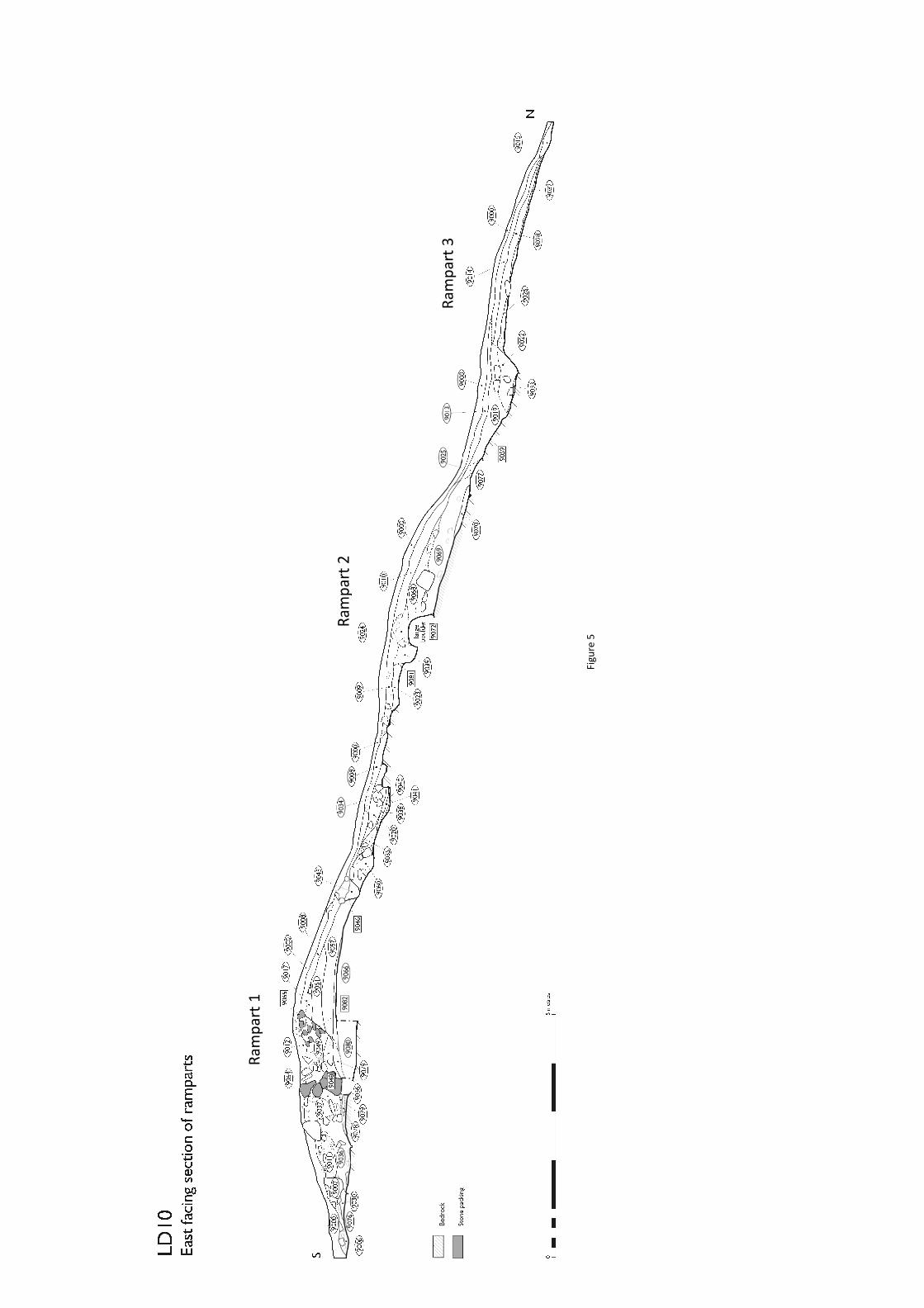
Rampart 3
The outermost rampart (Rampart 3) survived as a low mound (approximately 5m wide and
0.4m high) and was composed of four similar deposits of silt and silty clay with small angular
stone (9032, 9026, 9028 & 9014). Within the uppermost of these layer (9014) a
hammerstone (SF 9044) and possible coarse stone tool fragment (SF 9045) was found. At the
northernmost edge of this rampart was a thin narrow band of dark reddish brown clayey silt
(9015) which extended beyond the end of the trench. This deposit may have been material
which had slumped from the core of the rampart or perhaps a ditch fill.
Defining the southern edge of Rampart 3 was a shallow ditch (2.3m wide by 0.6m deep)
[9059]. This ditch was steeply cut into the subsoil on the north side. Towards the south the
ditch cut came to be defined by the underlying bedrock (9058), which gradually sloped
upwards towards Rampart 2. In the southwest corner the bedrock appeared to have been
purposefully chipped away to form a relatively even surface. At the base of the ditch was a

Law of Dumbuils Excavations 2010
- 6 -
thin lens of reddish orange silty clay (9033), which on the interface with the layer above a
small iron rod fragment (SF 9050) was recorded. Above this lens, distinctly banked on the
north side of the ditch, was a deposit of clayey silt with a moderate amount of medium
stone (9022), likely to be collapse from Rampart 3.
Figure 3: Plan view of ditch showing bedrock on south side
Figure 4: East facing section of ditch
Fig
ure
5

Rampart 2
At the southern edge of the ditch [9059], towards Rampart 2, was a small spread of reddish
pink clay subsoil (9077), measuring roughly 1.2m long by 0.6m wide. Overlapping this clay
subsoil and an area of exposed bedrock was a thin (less than 0.1m thick) layer of mottled
clay (9070). This layer filled a shallow hollow between the bedrock and subsoil. The upper
end of Rampart 2 was defined by massive boulders (one of which measured over 0.8m long
by 0.8m wide and 0.8m deep) and other stones. On the north side of these stones the
substantial earthen core of Rampart 2 was deposited, characterised by layers of greyish and
reddish brown clay with occasional flecks of charcoal and burnt bone (9069 & 9068). On the
summit of the rampart overlying the line of boulders was a layer of yellowish brown silt with
frequent stone (9024). To the south of this, on the summit of Rampart 2, was a narrow ditch
or pit [9081] (0.6m wide and 0.6m deep) with a dark greyish brown clayey silt fill (9039). This
cut feature was not clear in plan due to rubble material from 9024 collapsing into the fill and
thus making it indistinguishable on the surface. This feature also cut into a spread of
medium brown silty clay (9023) located o the south of Rampart 2, on a relatively level
surface directly above subsoil.
Collapse of Rampart 2 would have largely fallen towards the north. Spreading down the
north face of Rampart 2 was orange brown sandy silt deposits (9010 & 9027). At the base of
the rampart was a layer of angular stone (including slate fragments (SF 9043)) within a
clayey silt matrix (9025), containing charcoal and burnt bone fragments. This layer may
either be tumble from higher up the rampart or traces of a stone revetment which has been
disturbed by later erosion. Above this layer and filling the ditch [9059] was a deposit of
clayey silt (9019) with distinctly less stone than 9025. Above this was a thin layer of reddish
brown clayey silt and gravel (9013), similar to the erosion layer 9010 on the north face of
Rampart 2.
Rampart 1
In between Rampart 2 and Rampart 1 was a fairly level area with outcropping bedrock near
to the ground surface. Surrounding the outcropping bedrock, and above the subsoil, was a
very thin lens (less than 0.05m) of clay (9040). At edge of the base of Rampart 1, above the
clay 9040, was a thin lens of slick dark greyish brown clay (9041) and a deposit black brown
clayey silt (9038), both containing flecks of charcoal.
The lowest level of Rampart 1, above bedrock, was a 0.35m thick layer of pink silty clay
(9080), which was partially disturbed by animal burrows. This layer may have been natural
glacial till or redeposited natural. Above this was a thin (maximum 0.05m) dark pink silt layer
(9066), perhaps a burnt surface or an old turf line. The earthen core of this rampart was
largely composed of reddish brown and greyish brown silts with the upper layers containing
more stones (9057, 9061 & 9017 from lowest to highest respectively). Near the base of the
northern face of the rampart, cutting into the reddish brown earthen core material (9057),
was a narrow (0.4m) ditch or pit [9046] filled with a dark brown silt with flecks of charcoal
(9045). The north side of this feature was supported by a deposit of silty clay with medium
(0.3m by 0.3m by 0.2m) subangular stones (9060), which were purposefully set within the
soil matrix forming a revetment and defining the outer face for Rampart 1 (see Figure 6 & 7).
Overlapping this stone facing and spreading north was a dark brown silt containing small to
medium stones and occasional charcoal and burnt bone (9035). Above this was a dark clay
silt layer with more collapsed stone (9020), which included slag (SF 9029), some burnt bone
fragments and two hammerstones (SFs 9021 & 9036). On top of this and spreading onto
outcropping bedrock in between Rampart 1 and 2 was a rubble layer (9034) containing

Law of Dumbuils Excavations 2010
- 9 -
stones of varying sizes, some up to 0.7m in dimension. Further erosion and slump of reddish
silt (9008) from Rampart 1 had extended across along its north face and merged with similar,
but less stony material (9009) to the north.
Figure 6: Revetment 9060 near the base of the north face of Rampart 1, with possible palisade or pit
above it
Figure 7: W-facing section showing revetment 9060 near the base of the north face of Rampart 1,
with possible palisade or pit above it
Law of Dumbuils Excavations 2010
- 10 -
At some point after the earthen core of Rampart 1 was established the southern end was
deeply cut into [9082]. It is unclear how much of the original rampart was destroyed or
removed, but the cut was curving and over 0.5m deep.
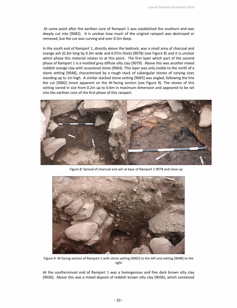
In the south end of Rampart 1, directly above the bedrock, was a small area of charcoal and
orange ash (0.3m long by 0.3m wide and 0.07m thick) (9078) (see Figure 8) and it is unclear
which phase this material relates to at this point. The first layer which part of the second
phase of Rampart 1 is a mottled grey diffuse silty clay (9079). Above this was another mixed
reddish orange clay with occasional stone (9064). This layer was only visible to the north of a
stone setting [9048], characterised by a rough stack of subangular stones of varying sizes
standing up to 1m high. A similar stacked stone setting [9065] was angled, following the line
the cut [9082] (most apparent on the W-facing section (see Figure 9). The stones of this
setting varied in size from 0.2m up to 0.6m in maximum dimension and appeared to be set
into the earthen core of the first phase of this rampart.
Figure 8: Spread of charcoal and ash at base of Rampart 1 9078 and close up
Figure 9: W-facing section of Rampart 1 with stone setting [9065] to the left and setting [9048] to the
right
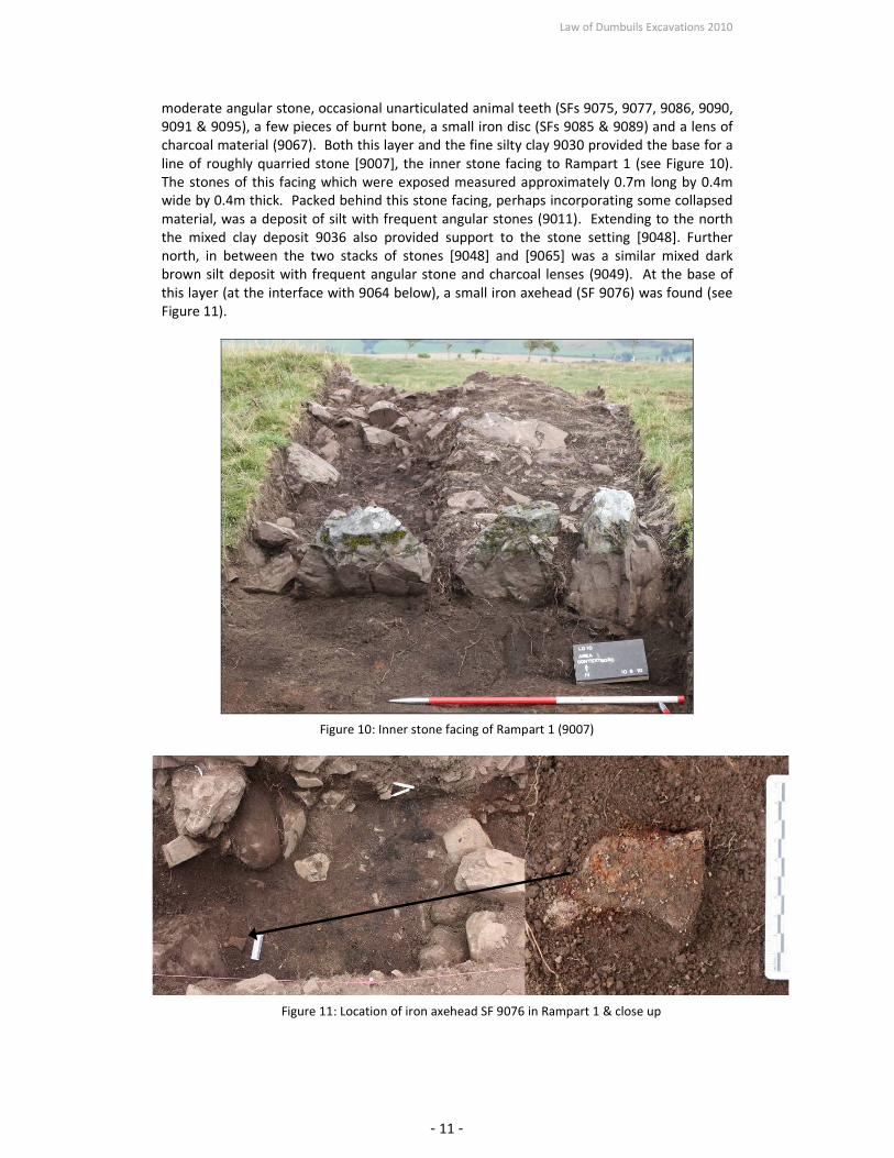
At the southernmost end of Rampart 1 was a homogenous and fine dark brown silty clay
(9030). Above this was a mixed deposit of reddish brown silty clay (9036), which contained
Law of Dumbuils Excavations 2010
- 11 -
moderate angular stone, occasional unarticulated animal teeth (SFs 9075, 9077, 9086, 9090,
9091 & 9095), a few pieces of burnt bone, a small iron disc (SFs 9085 & 9089) and a lens of
charcoal material (9067). Both this layer and the fine silty clay 9030 provided the base for a
line of roughly quarried stone [9007], the inner stone facing to Rampart 1 (see Figure 10).
The stones of this facing which were exposed measured approximately 0.7m long by 0.4m
wide by 0.4m thick. Packed behind this stone facing, perhaps incorporating some collapsed
material, was a deposit of silt with frequent angular stones (9011). Extending to the north
the mixed clay deposit 9036 also provided support to the stone setting [9048]. Further
north, in between the two stacks of stones [9048] and [9065] was a similar mixed dark
brown silt deposit with frequent angular stone and charcoal lenses (9049). At the base of
this layer (at the interface with 9064 below), a small iron axehead (SF 9076) was found (see
Figure 11).
Figure 10: Inner stone facing of Rampart 1 (9007)
Figure 11: Location of iron axehead SF 9076 in Rampart 1 & close up

Law of Dumbuils Excavations 2010
- 12 -
Cut into the lower rampart deposit (9036) and utilising the north side of the stone setting
[9048] was a possible posthole or pit [9083] measuring 0.6m wide and 0.7m in depth. This
possible posthole was filled with dark silty clay (9037).
At the summit of Rampart 1, above the stones [9065] was a deposit of mixed angular stones
(9018). To the south of this was a layer of mid brown silt (9012) containing less stone than
(9018) and similar to the topsoil (9000). Both of these layers are likely to have been
disturbed rampart deposits. Some collapse from the rampart is visible in a spread of reddish
brown silt with inclusions of angular stone (9006) located to the south of the stone facing
[9007].
Inside Rampart 1: Hollow way (not illustrated)
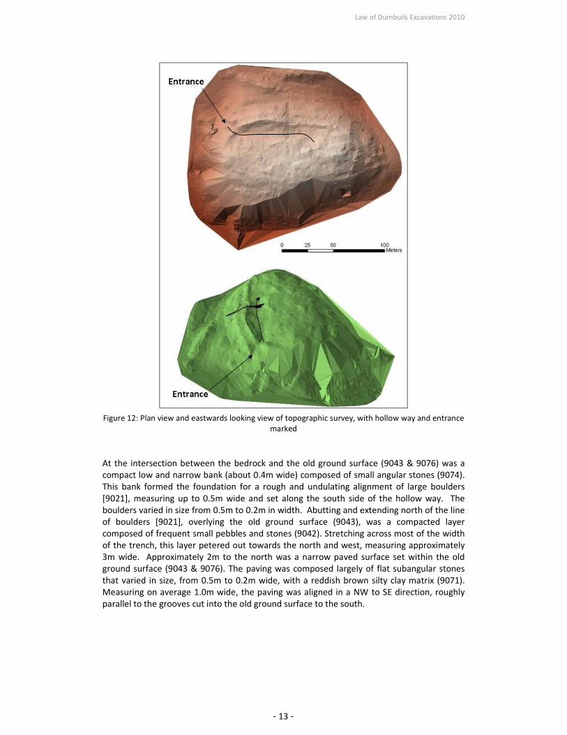
To the south of Rampart 1 was a shallow hollow way. This hollow way was utilised as part of
the entranceway, leading from the entrance on the northwest side of the hillfort into the
interior (this can be seen in the topographic survey Figure 12). The south end of the hollow
way was defined by natural bedrock (9029), which was uncovered less than 0.2m below the
topsoil as it sloped up towards in the south. At the base of the hollow was a natural glacial
till (9075, 9073). Above this glacial till was a mottled orange and dark brown layer (9043 &
9076), which may have been turf or an old ground surface. Cut into the turf/old ground
surface (9043), near the centre of the hollow, were traces of two parallel narrow grooves
spaced 1m apart (each measured approximately 0.2m wide and 0.2m deep). These were
only visible at the west side of the trench and taper out to the east, with the northern one
most visible (see Figure 16).
Law of Dumbuils Excavations 2010
- 13 -
Figure 12: Plan view and eastwards looking view of topographic survey, with hollow way and entrance
marked
At the intersection between the bedrock and the old ground surface (9043 & 9076) was a
compact low and narrow bank (about 0.4m wide) composed of small angular stones (9074).
This bank formed the foundation for a rough and undulating alignment of large boulders
[9021], measuring up to 0.5m wide and set along the south side of the hollow way. The
boulders varied in size from 0.5m to 0.2m in width. Abutting and extending north of the line
of boulders [9021], overlying the old ground surface (9043), was a compacted layer
composed of frequent small pebbles and stones (9042). Stretching across most of the width
of the trench, this layer petered out towards the north and west, measuring approximately
3m wide. Approximately 2m to the north was a narrow paved surface set within the old
ground surface (9043 & 9076). The paving was composed largely of flat subangular stones
that varied in size, from 0.5m to 0.2m wide, with a reddish brown silty clay matrix (9071).
Measuring on average 1.0m wide, the paving was aligned in a NW to SE direction, roughly
parallel to the grooves cut into the old ground surface to the south.

Law of Dumbuils Excavations 2010
- 14 -
Figure 13: Compacted stone 9074 under wall 9021
Figure 14: Line of stones or ‘wall’ 9021 from the west

Law of Dumbuils Excavations 2010
- 15 -
Figure 15: Wall 9021 with pebble surface 9043 and paving 9044 from the south
Figure 16: Paving (9044) set within old ground surface with groove visible to the left
To the north of the paved surface, above the old ground surface (9076) was a thin (0.05m)
clay spread (9005), measuring 2m wide. Above this and towards the inner face of Rampart 1
was a dark reddish brown deposit with patches of possible ash (9031), measuring 2.6m wide
and 0.2m in maximum depth. Medium angular stone collapsed from Rampart 1 (9006) was
deposited above this layer.
In the hollow way, above the pebble surface 9042 was a spread of large boulders (9016),
with individual stones measuring up to 0.5m in dimension, one of which had three cup-

Law of Dumbuils Excavations 2010
- 16 -
marks pecked on its surface (SF9019 - see Figure 18). These boulders were concentrated
more towards the western part of the trench and initially thought they have been the
remains of a structure. An extension (2m by 5m) was excavated to the west in order to
explore this possible feature; however, no clear edges were deciphered within the rubble.
Above this were further spreads of rubble composed of small angular stones within silt
matrices (9004, 9003 and 9002). These deposits appeared to have spread down from the
interior into the hollow and contained a variety of coarse stone tools (see Figure 19), such as
two cobble mortars (SF9014 & 9093), a rounded disk with a perforated hole (SF 9071),
circular disks or pot lids (SFs 9041 & 9055), a canal coal disk (SF 9037), possible
hammerstones and other worked stones (SFs 9022, 9016, 9038, 9042,9053 & 9060), as well
as a few bone fragments (SFs 9040, 9054 & 9096)
Figure 17: Spread of large boulders 9016 in hollow way
Figure 18: Cup stone rock (SF 9019) found within rubble 9016

Law of Dumbuils Excavations 2010
- 17 -
Stone with perforation SF 9071
Cobble mortar SF9014
Stone lid SF 9041
Canal coal disk SF 9037
Figure 19: Collection of some of the stone small finds found amongst the rubble within the hollow way
Topsoil
Extending across the entire trench was a rooty silt topsoil (9000/9001), on average 0.05m
thick. The topsoil contained glass (SFs 9002, 9004, 9005 & 9008), modern glazed pottery and
tile (SFs 9010, 9011 & 9013), metal wire (SF 9033) and some possible worked stone (SF 9001,
9007 & 9034)
Trench 2
A small 2m by 2m test pit was excavated within the interior of the fort towards the west end
(see Figure 2). The underlying bedrock (9052) sloped towards the west and was entirely
exposed less than 0.3m below the ground surface. Above this was a dark brown silt (9051)
with occasional fragments of degraded bedrock. Although it was deeper towards the west
end, it measured on average 0.17m deep. The topsoil was a mid brown silt (9050).

Law of Dumbuils Excavations 2010
- 18 -
Trench 3
A second 2m by 2m test pit was excavated further east in the interior, near to where the
hollow way slopes up into the centre (see Figure 2). At the base of this test pit bedrock
(9063) was reached between 0.5m and 0.7m below the surface. There was a rough circular
hollow in the bedrock (1.5m in diameter). At the edges of this hollow the bedrock had
degraded noticeably (9062). Above this, and filling the hollow was a deposit of dark silt with
frequent angular stone and occasional quartz pebbles (9055), measuring about 0.2m deep.
This deposit contained a few possible coarse stone tools (SFs 9059, 9061 & 9062). Above
this, towards the east side was a thin layer, similar to 9055, but with distinctly less stones
(9056). An orange brown silt with very occasional charcoal flecks (9054), 0.08m thick, lay
above this. A mid brown silt topsoil (9053) sealed the trench.
Figure 20: Test pit 2, top of bedrock
Figure 21: Test pit 3, top of 9055 and 9056 with 9054 removed

Law of Dumbuils Excavations 2010
- 19 -
Discussion
Ramparts
Rampart 3, the furthest from the interior, appeared to have been the most denuded only
surviving as a low mound. The whole extent of this rampart was not exposed in the trench;
however, the layers that were visible were predominantly composed of earth with medium-
sized stones near the summit. While most of the earthen material may have washed
downhill, some material appeared to have collapsed into the shallow ditch [9059] to the
south. This shallow ditch cut may have provided some of the material for Rampart 2 or 3,
but it appears that the bedrock lay very close to the surface when the ramparts were
constructed and therefore it is likely that subsoil was not the only source material. Within
the ditch [9059] the natural underlying slope of the bedrock was utilised to emphasis the
steepness of Rampart 2. Evidence for chipping away at the bedrock here also suggests the
builders attempted to create a smoother surface, one that would be more difficult to scale.
Rampart 2 did not form a characteristic mound or bank, with a ditch on either side. Instead
this rampart has a steep slope on the north side, but on the south side it was fairly level. The
core of this rampart was largely composed of earth and medium-sized stone, at least on its
north side. It may be that the quantity of stones within this material made it stable enough
to remain in position without support. Alternatively, the stony material (9025) identified
near the base of the north face of this rampart may represent the traces of a compacted
stone revetment, which had been disturbed by later erosion and collapse. At the summit, or
just above the break of slope, of this rampart were several substantial boulders, too big to
remove from the narrow trench. These boulders appeared to have been purposefully placed
and may have been used as support for a pit feature [9081], measuring 0.6m wide and set
directing behind the boulders. In plan the extent of this feature was not evident and may
have been obscured by rubble from the rampart (9024). The function of this pit is uncertain
but may have held timbers. To the south of Rampart 2 the bedrock was near the ground
surface and instead of cutting a ditch in the bedrock, a line of timbers here could have
created an alternative substantial obstacle.
Figure 22: Test pit 3, top of bedrock

Law of Dumbuils Excavations 2010
- 20 -
Rampart 1, the innermost rampart, was the most complex of the three, showing signs of at
least two phases of construction. The first phase of this rampart appears to be composed of
a mound of earth deposited on top of natural or redeposited natural (9080). The rampart
would have stood over 1.2m above the bedrock At the base of the north face there was
evidence for a revetment composed of medium sized stones (9060). Directly behind this
revetment was a narrow cut feature that may have supported upright timbers or larger
stones, which had subsequently been displaced. A spread of rubble, comprising some large
stones, was recorded to the north of Rampart 1, lying against the exposed bedrock (9034).
This material may have collapsed from the north face of Rampart 1, suggesting that at one
point there may have been a more substantial stone element to the north face of the
rampart.
After some time the southern slope of Rampart 1 was cut into and material added, creating
a very broad (over 7m wide) rampart. Under the rampart, directly above the bedrock, was a
spread of ash and charcoal – timber burnt in situ (9078). This deposit was discrete and it the
relationship between these remains and the second phase of Rampart 1 was unclear. The
rampart appeared to have been cut in order to secure large boulders into the depth of the
already established earthen core. Large stones, on top of one another [9065] were set along
the cut of the rampart. These stones along with another setting of stones [9048] less than
1m to the south were stablised within further earthen deposits (9036, 9064, 9049). The
earthen material (9030 & 9036) also provided the foundation for stone facing on the
southern edge of this rampart. Rough quarried stone, from nearby readily available bedrock,
was used in this facing.
The second phase of Rampart 1 may have also been supported by both upright and
horizontal timbers. Although possible post-holes (such as ([9083]/ 9037) were recorded in
section, the detection of postholes (or horizontal timber slots) in plan had not been
successful. It is possible that as timbers decayed or were removed the collapse of the
surrounding stones would have obscured the identification of distinct fills in plan.
Within the earthen material of this second phase of Rampart 1 two iron objects were found,
a small axehead SF 9076 and circular disk. Evidence of technology suggests that this phase
of Rampart 1 was constructed in or later than the Middle Iron Age.
Hollow way
The evidence uncovered within the hollow way to the south of Rampart 1 suggests that
there was at least one, perhaps more, built pathways. The flat stones, set into what appears
to be the remains of a turf or old ground surface (9044), formed a clear paved surface (about
1m wide) running from northwest to southeast, along the hollow way perhaps leading to
and from the entrance.
The length of this hollow way, and entrance, was also emphasised by the alignment of
stones set along the south side at intersection with the exposed bedrock (9021). Although
this alignment of stone was roughly built, the evidence of compacted stone underneath this
feature highlights intention and design behind its construction. The pebble surface abutting
this line of stones (9042) may have formed another pathway leading from the entrance,
perhaps a different phase of pathway. Unfortunately in this trench there was not a clear
relationship between this surface and the paving. The northern and western ends of the
pebble surface diffuse and irregular, perhaps suggesting it was disturbed by later activity in
this area.

Law of Dumbuils Excavations 2010
- 21 -
A deposit of boulders (9016) above the pebble surface (9042) appeared to form a rough arc
towards the west side of the trench, within the initial 2m width of the trench, andtherefore
it was initially suggested that these stones may have been the rubble of a roughly built
structure (which had incorporated a cup marked stone). The trench was extended to the
west to explore this. Although no clear wall lines were discernible, the amount of coarse
stone tools from this layer and from rubble material above this (9003 & 9004) suggests that
this area may have been at least a site of activity. Alternatively, the rubble and artefacts
may have fallen into the hollow way from the interior, although the pattern of rubble spread
does not fully support this suggestion.
Conclusions
The excavations at the Law of Dumbuils have highlighted variable preservation of the
ramparts of the fort. The ramparts were largely constructed of earth and rubble,
incorporating and adapting to the undulating nature of the underlying bedrock. While the
outermost and middle rampart appeared to have been built in one phase, there is evidence
of at least two phases of to the innermost rampart. The second phase added to the
southern, inner side of the rampart, perhaps broadening this rampart. Iron artefacts suggest
that this augmentation occurred sometime in or after the Middle Iron Age. The stone
elements of Rampart 1 (both phases) and Rampart 2, comprised unquarried boulders or
roughly quarried bedrock –material that was readily available nearby. Positioned together in
rough settings these stones were utilised more as packing than as structural features in
themselves – perhaps suggesting the use of timber as well. Overall, it appears that effort
was not made to dress stone, or even to cut into the underlying bedrock to create deep
ditches as seen at other forts. The builders used the materials that were readily available as
they were without spending time or effort modifying them.
Similar to the quality of construction noted in the ramparts, the stone recorded within the
hollow way leading to and from the northwest entrance of the hillfort was also roughly built.
The excavation revealed an alignment of stones set against the edge of the bedrock which
followed along the hollow way; however, this line was not coursed and was more sinuous
than straight. Other remains found were ephemeral or disturbed. Rubble and paved
surfaces in this area suggest there was activity and occupation within the hillfort, which was
further supported by a range of coarse stone tools found here, but the nature of this activity
was unclear. Exploration into the interior in the form of two small test pits did not produce
satisfactory results of structural remains, but the small sizes of these test pits and do not
preclude the possibility that structures could be found within the interior of this fort.

Acknowledgements
The author would like to thank Mr and Mrs Queisser of Glenearn Estate for their support of
this project; also to the estate manager Mr. Stewart Scott for his local knowledge and
interest. I would also like to thank Anne-Mare O’Donnell for keeping me organised and
being an invaluable assistant. The hard work was done by students from Aberdeen and
Glasgow Universities and local volunteers, Alex and Jennifer McKay (who were as always
fantastic). The project was sponsored by Historic Scotland (Archaeology Funding
Programme) and the Universities of Glasgow and Aberdeen. The research of SERF is
benefited by partnerships with the Royal Commission on the Ancient and Historical
Monuments of Scotland (www.rcahms.gov.uk) and Perth and Kinross Heritage Trust
(www.pkht.org.uk).
References
Maclagan, C (1875) The hill forts, stone circles and other structural remains of ancient
Scotland, Edinburgh held in the RCAHMS
New Statistical Account (1845) The new statistical account of Scotland by the ministers of
the respective parishes under the superintendence of a committee of the society for the
benefit of the sons and daughters of the clergy. Vol. 10, Perthshire, 953
Driscoll, S. T. 1987 The Early Historic Landscape of Strathearn: The Archaeology of a Pictish
Kingdom. Unpublished PhD thesis, Department of Archaeology, University of Glasgow.
Sherriff, J. R. 1978 The Prehistoric Fortifications of Strathearn, Perthshire. Unpublished
undergraduate thesis, Department of Archaeology, University College Cardiff.
Appendices
i) Contexts
Context
Number Area Type Description Interpretation
9000 1 Deposit light brown rooty silt topsoil
9001 1 Deposit
light brown rooty silt with
moderate small angular stone
on R2 mixed topsoil, same as 9000
9002 1 Deposit dark grey brown silt
slumped from revetment or interior at
south end of T1
9003 1 Deposit
mid brown silt with frequent
angular stone
secondary slumped material from
interior at south end of T1
9004 1 Deposit
mid dark reddish brown with
occasional angular stone; north
of 9003 spread on top of paved area
9005 1 Deposit
mid reddish brown clay;
occasional angular stone possible old ground surface south of R1
9006 1 Deposit
dark reddish brown silt with
moderate angular stone tumble from R1 to the south
9007 1 Structure
large angular (rough quarried)
stones in alignment on south
side of R1
in situ stone facing of R1, on top of
(9030)

Law of Dumbuils Excavations 2010
- 23 -
9008 1 Deposit
large spread of mid reddish
brown silt with frequent angular
stone across north face of R1 collapse from R1
9009 1 Deposit
same as 9008 with slightly less
stone collapse from R1 - continuation of 9008
9010 1 Deposit
mid orange brown sandy silt
with moderate gravel and
occasional small angular stone
on north face of R2 collapse from R2
9011 1 Deposit
mid yellow brown silt with
frequent angular stone; south
facing R1 upper layer of R1 on south side
9012 1 Deposit
mid brown silt with apparent
less frequent angular stone than
9011 or 9008
mix of topsoil and possible post-hole on
summit of R1
9013 1 Deposit
mid reddish brown clayey silt
with occasional pebbles and
gravel; very few angular stone slumping from R2 into ditch [9059]
9014 1 Deposit
mid reddish brown silt with
occasional angular stone on
north face R3
slumping and erosion of earthen and
stone core R3
9015 1 Deposit
mid dark reddish brown clayey
silt north of R3
slumping and erosion of earthen and
stone core of R3
9016 1 Deposit
large frequent angular
stones/boulders underlying
context 9003
tumble from possible revetment
structure 9021 in south end of T1 or
collapse of ephemeral stone structure.
9017 1 Deposit
loose reddish grey brown silt
with frequent part of earthen core of R1
9018 1 Deposit
mid reddish brown silt with
frequent medium angular stone
stone core/ packing material on summit
of R1
9019 1 Deposit
dark reddish brown clayey silt
with occasional charcoal fleck
under 9013
upper fill of ditch, slumping from the
direction of R2
9020 1 Deposit
dark gry brown smooth clayey
silt with large angular stones
under 9008 north of R1, some
charcoal, bone and very
occasional slag fragments
mix of collapsed material from R1 with
possible midden (see 9034)
9021 1 Structure
linear alignment of large angular
stones and rounded boulders
(one course high)
rough walling along edge of entrance
hollow
9022 1 Deposit
dark reddish brown clayey silt
with moderate stone fill of ditch, possible collapse from R3
9023 1 Deposit
mid reddish brown silty clay
with very occasional angular
stone deposit part of summit of R2
9024 1 Deposit
dark yellowish brown silt with
frequent angular stone
summit of R2, possible packing for
timber palisade (9039) - partially
collapsed
9025 1 Deposit
large angular stone collapse in
mid reddish brown clayey silt
matrix, oca charcoal and burnt
bone
possible collapse of R2 with mix of
midden material?

Law of Dumbuils Excavations 2010
- 24 -
9026 1 Deposit
orangey reddish brown silty clay
with moderate angular stone
possible core of R3, counterscarp to
ditch
9027 1 Deposit
same as 9010 but less angular
stone
transition layer between collapse 9010
and core rampart material 9068 of R2
9028 1 Deposit
mid grey yellowish brown clayey
silt with occasional angular
stone earthen and stone core of R3
9029 1 Deposit bedrock
bedrock in south end of trench, on which
wall 9021 constructed
9030 1 Deposit very dark brown silty clay
earthen base for stone facing to R1 9007,
second phase
9031 1 Deposit
dark reddish brown silt with
patches of black brown (ash?),
occasional flat stone
small area of flat stones and possible ash
immediately to the south of R1
9032 1 Deposit mid reddish brown clayey silt
thin layer / transition between natural
silt and core material from R3
9033 1 Deposit
mid reddish orange silty clay
under 9019 and 9028
basal fill of ditch, colour and texture
affected by decay of underlying bedrock
9034 1 Deposit
large angular stones abutting
bedrock outcrop on north side
of R1 in a random arrangement
possible tumble or collapse from R1,
possible stone facing
9035 1 Deposit
dark brown silt with small to
medium angular stone,
occasional charcoal patches and
bone fragments on north face of
rampart 2
slump material on couth face R1 and
midden material
9036 1 Deposit
mid reddish brown silty clay
with frequent angular stones,
bone (teeth) and iron objects
second phase of R1 material, earth and
stone possibly collapsed with decay of
timber element
9037 1 Deposit
very dark silty clay with
occasional angular stone
possible palisade slot fill supported by
surrounding stones in 9036 on the south
side and 9048 on the north side
9038 1 Deposit
dark black brown clayey silt
under stones 9034 with charcoal
and fragments of bone possible midden spread north of R1
9039 1 Deposit dark greyish brown clayey silt fill of possible palisade on summit R2
9040 1 Deposit reddish pink silty clay natural glacial till
9041 1 Deposit
greyish dark brown with reddish
flecks silty clay, occasional
charcoal flecks
thin layer / transition between midden
spread and natural glacial till
9042 1 Deposit
frequent small rounded and
subangular stone in a very dark
brown silty clay matrix
surface, possible floor associated with
wall 9012
9043 1 Deposit
mottled bright orange and very
dark brown silty clay, two
parallel groves in surface
possible old ground surface/turf south of
paving 9044 and under pebble surface
9042
9044 1 Deposit
flat subangular and angular
stones set into a slight curve area of paving
9045 1 Fill
dark blackish brown clayey silt
with small patches of charcoal
fill of possible rock hole for stone facing
on N slope of R1 or fill of a palisade/
post-hole
9046 1 Cut oval-shaped cut
cut of possible rock hole for stone facing
on N slope of R1 or fill of a palisade/
post-hole

Law of Dumbuils Excavations 2010
- 25 -
9047 1 Deposit same as 9057 R1 earthen core
9048 1 Structure
rough angular stone, three-four
courses high
possible stone packing (south side) for
timber on top of R1 (see 9065)
9049 1 Deposit
mid dark brown silt with
frequent angular stones
possible collapsed post or palisade
packing material deposited and mixed as
timber(s) decayed
9050 2 Deposit mid brown silt topsoil
9051 2 Deposit dark blackish brown silt soil accumulation above bedrock
9052 2 Deposit bedrock bedrock
9053 3 Deposit mid brown silt topsoil
9054 3 Deposit
orange brown silt with very
occasional fleck of charcoal possible old ground surface
9055 3 Deposit
dark silt with frequent stones,
occasional quartz pebbles
soil accumulation/ transition above
bedrock
9056 3 Deposit mid blackish brown silt
soil accumulation/ transition above
bedrock
9057 1 Deposit
mottled reddish orange and
brown silt
earthen core of R1 (first phase) natural
subsoil redeposited and mixed
9058 1 Deposit
bedrock, chipped and work on
west side bedrock exposed and chipped in ditch
9059 1 Cut
U-shaped with a rounded
bottom, north side steeper than
the north side cut of ditch
9060 1 Deposit
flat medium and small angular
and subangular set in a matrix
of silty clay
possible revetment at base of R1,
support for possible palisade/facing
9047
9061 1 Deposit orangey red brown silt
earthen core of R1 (first phase) natural
subsoil redeposited and mixed
9062 3 Deposit
mid orange and brown silt with
frequent stone degraded bedrock
9063 3 Deposit bedrock bedrock
9064 1 Deposit
mottled reddish orange brown
clay with occassional stone
part of earthen base (with 9079?) of
secondary phase of R1
9065 1 Structure
subangular and angular stones
of varying sizes, stacked up to
five courses on the E side to a
height of 0.7m
possible stone packing (north side) for
timber on top of R1 (see 9048)
9066 1 Deposit
thin layer (0.05m) of reddish
pink clayey silt with occasional
blackish brown patches
possible burnt turf or redeposited
material forming base of R1
9067 1 Deposit lens of charcoal within 9036
burnt spread in rampart of second
phase, possible remains of timber
(horizontal element?) of rampart (near
base)
9068 1 Deposit
dark reddish brown silty clay
with moderate angular and
subangular stone of varying
sizes
earth and stone core of R2, some
possible slump from stone facing?
9069 1 Deposit
mid greyish brown clay with
occasional angular stone and
very occasional flecks of
charcoal and bone earth and stone core of R2
9070 1 Deposit
mid reddish orangey grey brown
thin deposit
basal layer of core of R2, levelling
bedrock

Law of Dumbuils Excavations 2010
- 26 -
9071 1 Deposit mid reddish brown silty clay matrix surrounding paving 9044
9072 1 Structure
large boulders and rounded
stones on top of R2
stone packing for palisade or post-hole
on summit of R2
9073 1 Deposit firm orangey brown silty clay
natural subsoil transition between OGS
9043 and bedrock
9074 1 Deposit
frequent small rounded and
subangular stone in greyish
brown matrix, sloped bank
foundation for wall 9021, levelling area
to bedrock 9029
9075 1 Deposit
mottled greyish yellow brown
gritty clay degrading bedrock
9076 1 Deposit
mottled bright orange and very
dark brown silty clay
possible old ground surface/turf north of
paving 9044
9077 1 Deposit
reddish pink silty clay with
occasional gravel
natural glacial till spread on bedrock at
base of R2
9078 1 Deposit
discrete deposit of orange ash
and large charcoal pieces
wedged under stone packing
9048, on top of bedrock
in situ burning of timber at base of phase
2 of R1, possible horizontal element to
rampart or initial clearance of ground to
construct rampart
9079 1 Deposit
mottled greyish brown silty clay,
diffuse and undulating
possible basal layer of phase 2 of R1,
undulating and disturbed deposit
9080 1 Deposit reddish pink clay
natural glacial (redeposited) above
bedrock, base of phase 1 to R1
9081 1 Cut
U-shaped with a rounded
bottom, 0.6m by 0.6m
possible palisade trench or pit on
summit of Rampart 2
9082 1 Cut
Curved cut in profile, truncating
the N side of earthen material of
R1
Truncation of earthen core of R1 to build
a more stone construction
9083 1 Cut
U-shaped in profile, only visible
in section
Cut of possible posthole/palisade in R1
(9037)
ii) Small Finds
Find
Number Area Context Material Description
No of
Pieces Easting Northing Height
9001 1 9001 Stone
Small sherd of agate
possibly worked 1 1000.85 984.7 996.6
9002 1 9001 Glass Dark brown fragment 1 1002.31 990.72 998.34
9003 1 9001 Bone Small burnt fragment 1 1002.57 991.15 998.38
9004 1 9001 Glass
Green/brown neck
fragment 1 1001.38 988.82 997.45
9005 1 9001 Glass Small green sherd 1 1002.36 996.11 999.18
9006 1 9001 Daub Orange daub/clay 1 1001.15 989.9 997.91
9007 1 9001 Stone Hammerstone? Rubber? 1 1001.87 989.5 997.81
9008 1 9001 Glass Small green sherd 1 1001.96 995.45 998.86
9010 1 9001 Tile Glazed clay fragment 1 997.45 1004.6 998.95
9011 1 9001 Pottery
Small dark glazed
fragment 1 998.1 1005 998.9
9012 1 9001 Bone Very small burnt fragment 1 997.5 1007.2 998.03
9013 1 9001 Pottery Small white glazed sherd 1 997.38 1004 999.12
9014 1 9003 Stone Rough cobble mortar 1 998.64 989.75 999.47
9015 1 9008 Bone Small burnt fragment 1 997.89 1003.6 999.22
9016 1 9003 Stone
Possible hammerstone?
Rubber? 1 998.33 990 999.42
9017 1 9019 Bone Small burnt fragment 1 997.54 1013.5 996.65

Law of Dumbuils Excavations 2010
- 27 -
9018 1 9008 Bone Small burnt fragment 1 997.08 1003.2 999.31
9019 1 9016 Stone
Large stone including cup
and ring markings 1 997.98 987.85 999.64
9020 1 9005 Stone Pounder/ Hammerstone 1 997.69 993.18 999.11
9021 1 9020 Stone Hammerstone 1 997.57 1004.1 999.8
9022 1 9002 Stone
Possible
pounder/hammerstone 1 997.84 986.92 999.76
9023 1 9019 Bone Small burnt fragment 1 997.81 1012.8 996.66
9024 1 9012 Pottery
Small sherd, glazed with
blue and white decoration 1 998.92 999.96 1000
9025 1 9012 Glass small green fragment 1 998.22 999.72 1000.1
9026 1 9020 Bone Large burnt fragment 1 998.28 1003.2 999.28
9027 1 9020 Bone Small burnt fragment 1 998.48 1003.4 999.1
9028 1 9019 Bone Small burnt fragment 2 997.52 1013.5 996.56
9029 1 9020 Slag Small fragments 5 999.1 1004.6 998.67
9030 1 9012 Bone Small burnt fragment 1 999.37 998.1 1000.1
9031 1 9020 Bone Small burnt fragments 16 999.08 1004.6 998.66
9032 1 9013 Charcoal Large fragment 1
9033 1 9001 Metal Wire and ring - modern 1
9034 1 9001 Stone Possible worked stone 1
9035 1 9020 Bone Small burnt fragment 1
9036 1 9020 Stone Possible hammerstone? 1 994.77 1010.1 998.26
9037 1 9003 Stone
Rough out for a canal
coal/lignite object 1 996.9 989.08 999.44
9038 1 9003 Stone Possible worked stone 1 996.4 990.62 999.17
9039 1 9038 Bone Small burnt fragment 1 999 1005.4 998.19
9040 1 9003 Bone Small burnt fragment 1 996.94 992.5 999.18
9041 1 9003 Stone
Pot lid? Circular worked
stone 2 996.8 992.4 999.18
9042 1 9003 Stone
Small smooth rounded
stone, rubber? Broken 1 996.8 992.4 999.18
9043 1 9025 Stone Slate fragments 3
9044 1 9014 Stone Hammerstone 1 999 1018 996.27
9045 1 9014 Stone
Worked stone? Quern
fragment? 1 999 1018 996.27
9046 1 9003 Stone
Small smooth pebble,
gaming piece? 1 995.96 991.31 999.35
9047 1 9037 Bone Small burnt fragments 2 998.25 1004.7 998.47
9048 1 9037 Bone Small burnt fragment 1 998.42 1004.8 998.45
9049 1 9037
Bone
and
Charcoal
Small burnt fragment with
charcoal 3 998.7 1005.1 998.42
9050 1 9033 Metal Small iron rod fragment 1 998.28 1003.2 996.43
9051 1 9035 Bone Small burnt fragment 1 997.82 1003.1 999.33
9052 1 9035 Bone Animal teeth, horse? 1 998.11 1003.6 999.01
9053 1 9003 Stone Worked edge? 1 995.2 990.2 999.24
9054 1 9003 Bone Small burnt fragment, rib? 1 996.2 990.07 999.22
9055 1 9003 Stone
Pot lid? Circular worked
stone 1 996.66 990 999.38
9056 1 9019 Stone
Small rounded stone
pebble, Sling shot? 1

Law of Dumbuils Excavations 2010
- 28 -
9057 1 9030 Bone Small burnt fragments 15 997.392 996.27 999.3
9058 1 9044 Bone Small burnt fragment, rib? 1 998.353 991.18 999.64
9059 3 9055 Stone
Blunt stone tool/ possible
hammerstone? 1 1016.86 983.37 1000.3
9060 1 9003 Stone Rounded stone, worked? 1 996.243 989.49 999.29
9061 3 9055 Stone
Possible coarse stone tool
fragment, rubber?
Grinder? 1 1015.56 983.27 1000.4
9062 3 9055 Stone
Possible coarse stone tool,
rubber? Grinder? 1 1016.31 983 1000.4
9063 1 9016 Bone Small burnt fragment 1 997.301 989.61 999.27
9064 3 9055 Stone Quartz flake? 1 1016.26 984.26 1000.2
9065 1 9064 Bone Animal teeth 1 997.801 998.75 999.6
9066 1 9016 Stone Pounder/ Hammerstone 1
9067 1 9016 Bone Small burnt fragment 1 996.461 988.86 999.34
9068 1 9024 Bone Small burnt fragments 5 997.435 1008.8 998.19
9069 1 9016 Bone Small burnt fragment 1 996.395 988.24 999.38
9070 1 9016 Bone
Small burnt fragment very
small 1 995.858 988.12 999.41
9071 1 9002 Stone
Rounded disk with
perforated hole through
centre 1 996.576 986.92 999.7
9072 1 9016 Daub Small lumps 2 996.779 987.84 999.52
9073 1 9016 Stone Broken hammerstone 1 997.615 987.89 999.41
9074 1 9027 Clay Pieces of broken clay 2 997.977 1010.5 997.42
9075 1 9036 Bone
Animal teeth, horse?
Fragmented many 997.936 998.24 999.62
9076 1 9049 Metal Fe, metal object, axehead 1 997.916 998.69 999.57
9077 1 9036 Bone
Small burnt fragments and
teeth enamel many 997.579 998.29 999.56
9078 1 9036 Bone
Animal teeth, horse?
Fragmented many 997.323 998.31 999.63
9079 1 9036 Bone Small burnt fragment 1 997.227 997.64 999.58
9080 1 9011 Stone
Small rounded stone, red
and distinct 1 998.909 998.03 999.81
9081 1 9036 Bone Small burnt fragment 1
9082 1 9064 Bone Small burnt fragment 1 998.056 999.28 999.48
9083 1 9036 Bone Small burnt fragment 1 997.95 997.5 999.7
9084 1 9036 Bone Small burnt fragment 1 998.1 997.46 999.43
9085 1 9036 Metal
Fe, circular object, horse
piece? Harness? 1 997.9 997.86 999.39
9086 1 9036 Bone
Animal teeth, horse?
Fragmented many 997.37 998.07 999.47
9087 1 9036 Bone Small burnt fragments 2 996.6 997.32 999.05
9088 1 9036 Bone Small burnt fragment 1 995.8 997.68 999.15
9089 1 9036 Metal
Fe, part of circular object
9085 2 997.831 998.18 999.33
9090 1 9036 Bone
Animal teeth, horse?
Fragmented many 997.534 997.75 999.65
9091 1 9036 Bone
Animal teeth, horse?
Fragmented many 997.328 997.72 999.28
9092 1 9036 Bone Small burnt fragment 1 997.485 997.83 999.23
9093 1 9004 Stone Rough stone mortar 1 996.507 991.53 999.07
9094 1 9036 Bone Small burnt fragment 1 997.599 997.25 999.19

Law of Dumbuils Excavations 2010
- 29 -
9095 1 9036 Bone Animal tooth ?horse 1 997.631 997.35 999.17
9096 1 9004 Bone Small burnt fragment 1 995.958 992.29 999.05
9097 1 9036 Bone Small burnt fragment 1 997.805 998.52 999.37
9098 1 9036 Bone Small burnt fragment 1 997.58 998.38 999.2
9099 1 9036 Bone Small burnt fragments 4 997.833 998.28 999.22
9100 1 9078 Bone Small burnt fragments 3 997.639 998.66 999.25
9101 1 9004 Bone
Small burnt fragments
found in mortar SF 9093 2 996.507 991.53 999.07
9102 1 9033 Charcoal
Stem fragment - hand
collected by context 1
9103 1 9010 Bone
Small burnt bone
fragment - hand collected
by context 1
9104 1 9013 Bone
Small burnt bone
fragments - hand collected
by context many
9105 1 9020 Bone
Small burnt bone
fragments - hand collected
by context 11
9106 1 9069 Bone
Small burnt bone
fragments - hand collected
by context 4
9107 1 9008 Bone
Small burnt bone
fragments - hand collected
by context 6
iii) Drawings
Drawing
Number Area Type Subject Description Scale
Drawn
By Date
9001 1 Plan
9008, 9009,
9010, 9011,
9013 Pre-ex plan R1-R2 1:50 SHA 05/08/2010
9002 1 Plan
9002, 9003,
9004, 9005,
9006, 9007,
90012
Pre-ex plan of D1 and south
face of R1 1:50 CLG 05/08/2010
9003 1 Plan 9017, 9020 9008 removed on west side 1:50 SHA 08/08/2010
9004 1 Plan
9021, 9016,
9029
top of bedrock, wall and
collapse in South end of
trench 1 1:20 AOD 10/08/2010
9005 1 Plan
9005, 9007,
9031, 9030 Plan of South face of R1 1:20 AOD 10/08/2010
9006 1 Plan
9017, 9035,
9034, 9023
Plan of North face of R1 and
area between R1 and R2 1:20 LCU 12/08/2010
9007 1 Plan 9034, 9018 1:20 AOD 12/08/2010
9008 1 Plan 9002, 9003
Pre-ex of extension in south
of trench 1:50 TIP 13/08/2010
9009 2 Plan 9052 Test-pit in Area 2 Bedrock 1:10 NBA 13/08/2010
9010 3 Plan 9054
Test-pit, topsoil removed,
9054,9055 1:20 NBA 14/08/2010
9011 1 Plan 9016 Extension - 9003 removed 1:20 TIP 14/08/2010
9012 1 Plan 9012
South end T1 from 9012 to
paving 1:20 CLG 20/08/2010
9013 3 Plan 9063 Post-ex plan of test pit, 1:20 NBA 20/08/2010

Law of Dumbuils Excavations 2010
- 30 -
bedrock
9014 1 Section 9072
East facing section of North
slope R2 1:10 LCU 20/08/2010
9015 1 Section
9000, 9014,
9015, 9028,
9032
East facing section of R3 (two
pages) 1:10
MRI &
NBA 20/08/2010
9016 1 Section
9059, 9033,
9022, 9019,
9013
East facing section of Ditch
[9059] between R2 and R2 1:10 LCU 20/08/2010
9017 1 Section
9060, 9009,
9023, 9039
East facing section between
R1 and R2 1:10
MRI &
NBA 21/08/2010
9018 1 Section
9036, 9005,
9004, 9003,
9016,
West facing section south of
R1 1:10
NBA &
AOD 21/08/2010
9019 1 Section
9021, 9073-
9075, 9002,
9003
West facing section south
end of Trench 1, wall 9021 1:10
NBA &
AOD 21/08/2010
9020 1 Plan 9068 Post-ex plan of base of R2 1:20 LME 21/08/2010
9021 1 Section 9044, 9071
East facing section of paving
9044 1:10 LME 21/08/2010
9022 1 Section
9064, 9079,
9048, 9049
9065, 9080,
9012 East facing section of R1 1:10 LCU 21/08/2010
9023 1 Plan 9044, 9071
Overlay of drawing 9012
showing paved surface in
OGS and location of slot 1:20 CLG 21/08/2010
9024 1 Section
9064, 9079,
9048, 9049,
9065, 9080 West facing section of R1 1:10
TIP &
CMA 21/08/2010
9025 1 Section
9057, 9061,
9066, 9060,
9046, 9045,
9035 West facing section of R1 1:10 LME 21/08/2010
iv) Samples
Sample
Number Context BagSizeNo
Volume
(L) Reason
Taken
by Date
9001 9019 2L 20
Botanics and Carbonised
Material for ID and C14 JMK 10/08/2010
9002 9020 2L 20
Botanics and Carbonised
Material for ID and C14 SHA 11/08/2010
9003 783 2L
Botanics and Carbonised
Material for ID and C14 JMK 11/08/2010
9004 9014 1L 10
Botanics and Carbonised
Material for ID and C14 MRI 12/08/2010
9005 9013 2L 20
Botanics and Carbonised
Material for ID and C14 JMK 13/08/2010
9006 9038 2L 20
Burnt bone, botanics
and Carbonised Material
for ID and C14 SHA 13/08/2010
9007 9017 2L 20
Burnt bone, botanics
and Carbonised Material
for ID and C14 SHA 13/08/2010

Law of Dumbuils Excavations 2010
- 31 -
9008 9054 2L 20
Botanics and Carbonised
Material for ID and C14 NBA 14/08/2010
9009 9033 2L 20
Botanics and Carbonised
Material for ID and C14 NBA 14/08/2010
9010 9035 1L 5
Botanics and Carbonised
Material for ID and C14 AOD 17/08/2010
9011 9045 1L 5
Botanics and Carbonised
Material for ID and C14 AOD 17/08/2010
9012 9028 2L 20
Botanics and Carbonised
Material for ID and C14 MRI 17/08/2010
9013 9033 2L 20
Botanics and Carbonised
Material for ID and C14 JMK 17/08/2010
9014 9049 2L 20
Botanics and Carbonised
Material for ID and C14 AOD 18/08/2010
9015 9041 2L 20
Botanics and Carbonised
Material for ID and C14 TIP 18/08/2010
9016 9047 1L 10
Botanics and Carbonised
Material for ID and C14 AOD 18/08/2010
9017 9057 2L 20
Botanics and Carbonised
Material for ID and C14 AOD 18/08/2010
9018 9060 2L 20
Botanics and Carbonised
Material for ID and C14 SHA 19/08/2010
9019 9036 2L 20
Burnt bone, botanics
and Carbonised Material
for ID and C14 JMK 19/08/2010
9020 9049 2L 20
Botanics and Carbonised
Material for ID and C14 TIP 19/08/2010
9021 9064 1L 5
Botanics and Carbonised
Material for ID and C14 TIP 19/08/2010
9022 9066 1L 10L
Botanics and Carbonised
Material for ID and C14 AOD 19/08/2010
9023 9030 2L 20L
Botanics and Carbonised
Material for ID and C14 AOD 19/08/2010
9024 9069 2L 20
Burnt bone, botanics
and Carbonised Material
for ID and C14 LCU 19/08/2010
9025 9068 2L 20
Botanics and Carbonised
Material for ID and C14 LCU 19/08/2010
9026 9070 1L 10
Botanics and Carbonised
Material for ID and C14 LCU 19/08/2010
9027 9071 1L 2
Botanics and Carbonised
Material for ID and C14 AMK 20/08/2010
9028 9043 2L 20
Botanics and Carbonised
Material for ID and C14 AMK 20/08/2010
9029 9039 1L 5
Botanics and Carbonised
Material for ID and C14 TIP 20/08/2010
9030 9039 1L 10
Botanics and Carbonised
Material for ID and C14 NBA 20/08/2010
9031 9042 2L 20
Botanics and Carbonised
Material for ID and C14 AMK 20/08/2010
9032 9073 1L 7
Botanics and Carbonised
Material for ID and C14 AMK 20/08/2010

Law of Dumbuils Excavations 2010
- 32 -
9033 9042 1L 3
Botanics and Carbonised
Material for ID and C14 AMK 20/08/2010
9034 9078 2L 20
Botanics and Carbonised
Material for ID and C14 JMK 21/08/2010
9035 9078 1L 10
Botanics and Carbonised
Material for ID and C14 JMK 21/08/2010
9036 9074 1L 10
Botanics and Carbonised
Material for ID and C14 LCU 21/08/2010
9037 9079 1L 10
Botanics and Carbonised
Material for ID and C14 LCU 21/08/2010
9038 9023 2L 20
Botanics and Carbonised
Material for ID and C14 NBA 21/08/2010
v) Digital Photos
Film Frame Area Subject Description Direction
Taken
By Date
001 1 1 9008 pre-ex North face of R1 North SHA 04/08/2010
001 2 1 9008, 9009 pre-ex R1 to R2; south looking north South SHA 04/08/2010
001 3 1 9008, 9009 pre-ex R1 to R2; south looking north South SHA 04/08/2010
001 4 1 9014, 9015 pre-ex north facing view of R3 North TIP 04/08/2010
001 5 1 working shot of deturfinf trench 1 Southeast TIP 03/08/2010
001 6 1 working shot of deturfing trench 1 Southeast TIP 03/08/2010
001 7 1 working shot of deturfing trench 1 Southeast TIP 03/08/2010
001 8 1 9013 pre-ex north facing shot of D1 North CLG 05/08/2010
001 9 1 9013 pre-ex north facing shot of D1 North CLG 05/08/2010
001 10 1 9013, 9010 pre-ex south facing R1 and D1 South CLG 05/08/2010
001 11 1
9014, 9010,
9013 pre-ex north face of R2 and R3 North SHA 05/08/2010
001 12 1
9014, 9010,
9013 pre-ex north face of R2 and R3 North SHA 05/08/2010
001 13 1 9014, 9015 pre-ex north facing view of R3 South SHA 05/08/2010
001 14 1 9014, 9013
pre-ex south face shot of Ditch and
R3 South TIP 05/08/2010
001 15 1
9008, 9035,
9020
working shot of removal of context
9008 North SHA 07/08/2010
001 16 1
9008, 9035,
9020
working shot of removal of context
9008 North SHA 07/08/2010
001 17 1
9008, 9035,
9020
working shot of removal of context
9008 South SHA 07/08/2010
001 18 1 9007 facing stones of rampart 1 North TIP 07/08/2010
001 19 1 9007 facing stones of rampart 1 North TIP 07/08/2010
001 20 1
9005, 9006,
9031, 9007
S of R1 with collapse of material 9006
part removal South TIP 07/08/2010
001 21 1
9005, 9006,
9031, 9007
S of R1 with collapse of material 9006
part removal South TIP 07/08/2010
001 22 1
9005, 9006,
9031, 9007
S of R1 with collapse of material 9006
part removal North TIP 07/08/2010
001 23 1
9005, 9006,
9031, 9007
S of R1 with collapse of material 9006
part removal North TIP 07/08/2010
001 24 1 9002
pre-ex shot of north facing slope,
possible revetment North CLG 07/08/2010
001 25 1 9014 top of 9014 with 9015 removed North MRI 07/08/2010
001 26 1 9014 top of 9014 including 9015 removed South MRI 07/08/2010

Law of Dumbuils Excavations 2010
- 33 -
001 27 1 9020, 9017
working shot of 9017 and 9020, N
face of R1 North SHA 07/08/2010
002 1 1 9020, 9017
working shot of 9017 and 9020, N
face of R1 North SHA 07/08/2010
002 2 1 9002 Working shot of 9002 mid ex North AOD 07/08/2010
002 3 1 9016 NW shot of cup marked stone 9019 Northwest AOD 07/08/2010
002 4 1 9016 N shot of cup marked stone 9019 North AOD 07/08/2010
002 5 1 9016
Close up shot of cup marking on
stone 9019 North AOD 07/08/2010
002 6 1 9019 Top of 9019 with 9013 removed North LCU 07/08/2010
002 7 1 9019 Top of 9019 with 9013 removed South LCU 07/08/2010
002 8 1 9016
Working shot of 9016 context and
cup marked stone 9019 East AOD 07/08/2010
002 9 1 9016
Working shot of 9016 context and
cup marked stone 9019 North AOD 07/08/2010
002 10 1 9016
Working shot of 9016Working shot
Working shot of 9016 context and
cup marked stone 9019 North AOD 07/08/2010
002 11 1 9003 Shot of Mortar AOD 07/08/2010
002 12 1 Lunch time shot of gazebo and team South TIP 07/08/2010
002 13 1 Lunch time shot of gazebo and team South TIP 07/08/2010
002 14 1 9002
Working shot of S end of trench
9002, 9016, 9004, 9005, 9007 Northeast TIP 07/08/2010
002 15 1 9002
Working shot of S end of trench
9002, 9016, 9004, 9005, 9007 South TIP 07/08/2010
002 16 1 9003 Shot of Mortar TIP 07/08/2010
002 17 1 View of Law of Dumbuils Northwest TIP 07/08/2010
002 19 1
working shot of excavation south of
trench south TIP 08/08/2010
002 20 1
working shot of excavation south of
trench south TIP 08/08/2010
002 21 1 9021, 9029 working shot of south of trench South TIP 08/08/2010
002 22 1 9021, 9029 working shot of south of trench South TIP 08/08/2010
002 24 1 working shot of S end of trench Southeast TIP 07/08/2010
002 25 1 9002 working shot of S end of trench Southeast TIP 07/08/2010
002 26 1 9002 working shot of S end of trench Southeast TIP 07/08/2010
002 27 1 9002 working shot of S end of trench Southeast TIP 07/08/2010
002 28 1
9002, 9003,
9004 working shot of S end of trench Northeast TIP 07/08/2010
002 29 1 working shot of N face of R1 Northeast TIP 07/08/2010
002 30 1
working shot of area between R1 and
R2 East TIP 07/08/2010
002 31 1 working shot of R2 Southeast TIP 07/08/2010
002 32 1 working shot of R3 Southeast TIP 07/08/2010
002 33 1 working shot of R3 Northeast TIP 07/08/2010
002 34 1
working shot of trench in relation to
surrounding ramparts West TIP 07/08/2010
002 35 1
View of trench from neighbouring
knoll Northwest TIP 07/08/2010
002 36 1 Castle Law climb AOD 08/08/2010
003 1 1 View from Castle Law Forgandenny Southwest AOD 08/08/2010
003 2 1 View from Castle Law Forgandenny East AOD 08/08/2010
003 3 1 View from Castle Law Forgandenny East AOD 08/08/2010

Law of Dumbuils Excavations 2010
- 34 -
003 4 1 View from Castle Law Forgandenny East AOD 08/08/2010
003 5 1 sitting on ramparts of castle law Northeast TIP 08/08/2010
003 6 1
view of law of dumbuils in landscape
from Castle Law South TIP 08/08/2010
003 7 1
view of law of dumbuils in landscape
from Castle Law South TIP 08/08/2010
003 8 1 9029
view of bedrock 9029 & poss
revetment at South end of Area 1 North AOD 10/08/2010
003 9 1 9029
view of bedrock 9029 & poss
revetment at South end of Area 1 South AOD 10/08/2010
003 10 1 9016 top of rubble 9016 North AOD 10/08/2010
003 11 1 9016 top of rubble 9016 North AOD 10/08/2010
003 12 1 9020
working shot of 9020 - mid
excavation North TIP 10/08/2010
003 13 1 9020
working shot of 9020 - mid
excavation North TIP 10/08/2010
003 14 1 9007, 9030
9006 removed showing bank and
stone facing R1 south TIP 10/08/2010
003 15 1 9007, 9030
9006 removed showing bank and
stone facing R1 south TIP 10/08/2010
003 16 1 9007, 9030
9006 removed showing bank and
stone facing R1 south TIP 10/08/2010
003 17 1 9007, 9030
9006 removed showing bank and
stone facing R1 East TIP 10/08/2010
003 18 1 working shot of topographic survey North TIP 10/08/2010
003 19 1 9034
working shot of large angular stones
on R1 North SHA 11/08/2010
003 20 1 9034
working shot of large angular stones
on R1 North SHA 11/08/2010
003 21 1 9016, 9003
working shot of Alex deturfing
extention of 9016 North TIP 11/08/2010
003 22 1 9016, 9003
working shot of alex deturfing
extention of 9016 south TIP 11/08/2010
003 23 1 9016, 9003
view of south end extention looking
towards R1 south TIP 11/08/2010
003 24 1 9016, 9003
view of south end extention and
9016 south TIP 11/08/2010
003 25 1 9036
angular stone South face R1. Possible
rampart packing North AOD 12/08/2010
003 26 1 9036
angular stone South face R1. Possible
rampart packing North AOD 12/08/2010
003 27 1 9036
angular stone South face R1. Possible
rampart packing East AOD 12/08/2010
003 28 1 9001
working shot of cleaning SW end
Area 1 Southeast TIP 12/08/2010
003 29 1 9001
working shot of cleaning SW end
Area 1 North TIP 12/08/2010
004 1 1
Shot of amended gazeebo at lunch
during heavy rain North TIP 12/08/2010
004 2 1 9001
top of 9001 at extended south area
T1 North TIP 12/08/2020
004 3 1 9001
top of 9001 at extended south area
T1 North TIP 12/08/2010
004 4 1 9001 top of 9001 at extended south area South TIP 12/08/2010

Law of Dumbuils Excavations 2010
- 35 -
T1
004 5 1 9001
top of 9001 at extended south area
T1 South TIP 12/08/2010
004 6 2 9052 Bedrock in testpit 2 West NBA 12/08/2010
004 7 2 9052 Bedrock in testpit 2 South NBA 12/08/2010
004 8 General excavation shots - extension Northeast TIP 13/08/2010
004 9
General excavation shots - view
North from R1 South TIP 13/08/2010
004 10 View of topographic surveyor East TIP 13/08/2010
004 11 2 9052 Bedrock in testpit 2 West NBA 12/08/2010
004 12 1 9020, 9034
working shot of area between R1 and
R2 North TIP 14/08/2010
004 13 General shots of ramparts and trench Southeast TIP 14/08/2010
004 14 General shots of ramparts and trench Southeast TIP 14/08/2010
004 15 View of topographic surveyor South TIP 14/08/2010
004 16 General view of ramparts and trench East TIP 14/08/2010
004 17 Jeremy talking to Jennifer in trench East TIP 14/08/2010
004 18 Jeremy talking to Jennifer in trench East TIP 14/08/2010
004 19 1 Colette cleaning extension Southwest TIP 14/08/2010
004 20 1 9022
Top of 9022 in Ditch, some of deposit
9033 showing as well North TIP 14/08/2010
004 21 1 9022
Top of 9022 in Ditch, some of deposit
9033 showing as well South TIP 14/08/2010
004 22 1 9022
Top of 9022 in Ditch, some of deposit
9033 showing as well East TIP 14/08/2010
004 23 3 Test-pit 3 after removal of topsoil North NBA 14/08/2010
004 24 3 Test-pit 3 after removal of topsoil East NBA 14/08/2010
004 25 3 9054, 9055
Orangey brown soil, stones and
darker material in test pit North NBA 14/08/2010
004 26 3 9054, 9055
Orangey brown soil, stones and
darker material in test pit East NBA 14/08/2010
004 27 Canal coal/lignite object SF 9037 TIP 14/08/2010
004 28 Canal coal/lignite object SF 9037 TIP 14/08/2010
004 29
Colette showing her find to Lorraine
and Jennifer TIP 14/08/2010
004 30 1 9016
9003 removed in extension, showing
extent of rubble 9016 North TIP 14/08/2010
005 1 1 9016
9003 removed in extension, showing
extent of rubble 9016 South TIP 14/08/2010
005 2 1 9016
9003 removed in extension, showing
extent of rubble 9016 South TIP 14/08/2010
005 3 1 9016
9003 removed in extension, showing
extent of rubble 9016 East TIP 14/08/2010
005 4 1 9016
9003 removed in extension, showing
extent of rubble 9016 West TIP 14/08/2010
005 5 1 9016
9003 removed in extension, showing
extent of rubble 9016 West TIP 14/08/2010
005 6 1 9016
9003 removed in extension, showing
extent of rubble 9016 West TIP 14/08/2010
005 7 3
Working shot of Natalia with test pit
3 West TIP 14/08/2010
005 8 3
working shot of N face of R2 and
ditch North TIP 14/08/2010

Law of Dumbuils Excavations 2010
- 36 -
005 9 1 9044 first view of possible paving stones Southeast TIP 14/08/2010
005 10 Potlid from 9003 TIP 14/08/2010
005 11 1
9045, 9046,
9047
View of possible stone hole or
palisade near base of R1 North AOD 16/08/2010
005 12 1
9045, 9046,
9047
View of possible stone hole or
palisade near base of R1 North AOD 16/08/2010
005 13 1
9045, 9046,
9047
View of possible stone hole or
palisade near base of R1 North AOD 16/08/2010
005 14 1
9045, 9046,
9047
View of possible stone hole or
palisade near base of R1 North AOD 16/08/2010
005 15 1
9045-9047,
9017, 9057
Wider view of possible stone hole or
palisade near base of R1 North AOD 16/08/2010
005 16 1
9045-9047,
9017, 9057
Wider view of possible stone hole or
palisade near base of R1 North AOD 16/08/2010
005 17 1 Animal teeth in 9035 in base of R1 AOD 16/08/2010
005 18 3 9055, 9056
After removal of 9054 with new silt
layer 9056 North NBA 17/08/2010
005 19 1 Working shot of Tessa excavating North AOD 17/08/2010
005 20 1 9033 Reddish clay at base of Ditch North JMK 17/08/2010
005 21 1
9019, 9013,
9022 East-facing seciotn of Ditch East JMK 17/08/2010
005 22 1 9033 Reddish clay at base of Ditch South JMK 17/08/2010
005 23 1
9019, 9013,
9022 West-facing seciotn of Ditch West JMK 17/08/2010
005 24 1
9048, 9049,
9065
Possible post-hole/ stone setting in
Rampart 1, working shot South AOD 17/08/2010
005 25 1
9048, 9049,
9065
Possible post-hole/ stone setting in
Rampart 1, working shot South AOD 17/08/2010
005 26 1
9048, 9049,
9065
Possible post-hole/ stone setting in
Rampart 1, working shot East AOD 18/08/2010
005 27 1
9048, 9049,
9065
Possible post-hole/ stone setting in
Rampart 1, working shot South AOD 18/08/2010
005 28 1
9048, 9049,
9065
Possible post-hole/ stone setting in
Rampart 1, working shot South AOD 18/08/2010
005 29 1
9048, 9049,
9065
Possible post-hole/ stone setting in
Rampart 1, working shot - East facing
section East AOD 18/08/2010
005 30 1
9040 and
bedrock N of R1 - natural? North TIP 18/08/2010
005 31 1
9040 and
bedrock N of R1 - natural? West TIP 18/08/2010
005 32 1
9040 and
bedrock N of R1 - natural? South TIP 18/08/2010
005 33 1 9024 Rubble on summit of R2 East TIP 18/08/2010
005 34 1 9024, 9039
Rubble on summit of R2 & possible
posthole/palisade East TIP 18/08/2010
005 35 1 9039
Rubble on summit of R2 & possible
posthole/palisade North TIP 18/08/2010
005 36 1 9032, 9026
N face of R3 with stony layers
removed North MRI 18/08/2010
005 37 1 9032, 9026
N face of R3 with stony layers
removed South MRI 18/08/2010

Law of Dumbuils Excavations 2010
- 37 -
005 38 1
9019, 9022,
9033 E-facing section of Ditch East TIP 18/08/2010
006 1 1
9019, 9022,
9033 W-facing section of Ditch West TIP 18/08/2010
006 2 1 9059, 9058 Plan view of Ditch cut North TIP 18/08/2010
006 3 1 9059, 9058 Plan view of Ditch cut South TIP 18/08/2010
006 4 1 9059, 9058 Plan view of Ditch cut South TIP 18/08/2010
006 5 1
9047, 9046,
9045
View of charcoal from possible
posthole/palisade North AOD 18/08/2010
006 6 1
9047, 9046,
9045
View of charcoal from possible
posthole/palisade North AOD 18/08/2010
006 7 1
9060, 9047,
9057
Working shot of N face of R1,
showing packing stones and possible
palisade North AOD 18/08/2010
006 8 1 9060
working shot of packing stones at
base of R1 North AOD 18/08/2010
006 9 1 9057, 9060
Working shot of N face of R1,
showing packing stones and possible
palisade North SHA 18/08/2010
006 10 1 9026 Deposit on top of R3 East MRI 18/08/2010
006 11 1 9026 Deposit on top of R3 West MRI 18/08/2010
006 12 3
9055, 9062,
9063
Lower stones 9055, mottled deposit
9062 and bedrock 9063 S NBA 19/08/2010
006 13 1
9008, 9017,
9061, 9057,
9066 E-facing section of R1 East SHA 19/08/2010
006 14 1
9008, 9017,
9061, 9057,
9066 E-facing section of R1 East SHA 19/08/2010
006 15 1
9008, 9017,
9061, 9057,
9066 E-facing section of R1 East SHA 19/08/2010
006 16 1 9057, 9060 E-facing section of R1, lower slope East SHA 19/08/2010
006 17 1 9057, 9060 E-facing section of R1, lower slope East SHA 19/08/2010
006 18 1 9020, 9034
E-facing section of collapse at N base
of R1 East SHA 19/08/2010
006 19 1
General view from entrance of fort
towards Sma' Glen in the distance Southeast TIP 19/08/2010
006 20 1
Working shot of excavation in south
end of trench Southeast TIP 19/08/2010
006 21 1 Working shot through R1 South TIP 19/08/2010
006 22 1 Working shot through R1 South TIP 19/08/2010
006 23 1 Working shot through R1 South TIP 19/08/2010
006 24 1 Working shot through R1 South TIP 19/08/2010
006 25 1 SF9075
N-facing shot of large animal teeth in
R1 (close up) North TIP 19/08/2010
006 26 1 SF9075
N-facing shot of large animal teeth in
R1 (close up) North TIP 19/08/2010
006 27 1 SF9075
N-facing shot of large animal teeth in
R1 (wider context) North TIP 19/08/2010
006 28 1 SF9076
S-facing shot of axehead in R1 (close
up) South TIP 19/08/2010
006 29 1 SF9076
S-facing shot of axehead in R1 (close
up) South TIP 19/08/2010
Law of Dumbuils Excavations 2010
- 38 -
006 30 1 SF9076 Shot of axehead in R1 (wider context) East TIP 19/08/2010
007 1 1 9044, 9043
Top of paving in set in possible
turf/OGS West CLG 19/08/2010
007 2 1 9043 Top of turf in south end of trench West CLG 19/08/2010
007 3 1 9042
Top of small rounded stone surface
next to wall West CLG 19/08/2010
007 4 1 9042
Top of small rounded stone surface
next to wall 9021 West CLG 19/08/2010
007 5 1 9021, 9042
Wall in south end of trench and
pebble surface West CLG 19/08/2010
007 6 1
9021, 9042,
9043, 9044
Wall, pebble surface, turf and paving
in S end of trench South CLG 19/08/2010
007 7 1
9021, 9042,
9043, 9044
Wall, pebble surface, turf and paving
in S end of trench South CLG 19/08/2010
007 8 1 9021, 9042
Wall in south end of trench and
pebble surface East CLG 19/08/2010
007 9 1 9042
Top of small rounded stone surface
next to wall 9021 East CLG 19/08/2010
007 10 1 9043 Top of turf in south end of trench East CLG 19/08/2010
007 11 1 9044, 9043
Top of paving in set in possible
turf/OGS East CLG 19/08/2010
007 12 1 9064
Area of charcoal burning and iron
object SF9075 East TIP 19/08/2010
007 13 1 Working shot of section drawing R1 TIP 19/08/2010
007 14 1 Working shot of section drawing R1 TIP 19/08/2010
007 15 1 Working shot of section drawing R1 TIP 19/08/2010
007 16 1 SF9071
Stone with perforated hole in centre
SF9071, found in 9003 TIP 19/08/2010
007 17 1 SF9071
Stone with perforated hole in centre
SF9071, found in 9003 TIP 19/08/2010
007 18 1 SF9071
Stone with perforated hole in centre
SF9071, found in 9003 TIP 19/08/2010
007 19 3 9063 bedrock in testpit 3 North NBA 19/08/2010
007 20 3 9063 bedrock in testpit 3 West NBA 19/08/2010
007 21 1 9067, 9030
Charcoal spread/lense in R1
foundation 9030 South AOD 19/08/2010
007 22 1 9067, 9030
Charcoal spread/lense in R1
foundation 9030 South AOD 19/08/2010
007 23 1
9000, 9008,
9020, 9034
E-facing section of area between R1
and R2 East AOD 20/08/2010
007 24 1
9000, 9008,
9020, 9034
E-facing section of area between R1
and R2 East AOD 20/08/2010
007 25 1
9000, 9008,
9020, 9034
E-facing section of area between R1
and R2 East AOD 20/08/2010
007 26 1 SF9085 Circular iron object found in R1 TIP 20/08/2010
007 27 1 SF9085 Circular iron object found in R1 TIP 20/08/2010
007 28 1 SF9085 Circular iron object found in R1 TIP 20/08/2010
007 29 1 9040, 9061
Plan view of N-facing slope of R1,
natural? North AOD 20/08/2010
007 30 1 9040, 9061
Plan view of N-facing slope of R1,
natural? North AOD 20/08/2010
007 31 1
9000, 9014,
9028, 9032 E-facing section of R3 (summit) East MRI 20/08/2010

Law of Dumbuils Excavations 2010
- 39 -
007 32 1
9000, 9014,
9028, 9032 E-facing section of R3 East MRI 20/08/2010
007 33 1
9000, 9014,
9015, 9032 E-facing section of R3 East MRI 20/08/2010
007 34 1
9000, 9014,
9015, 9032 E-facing section of R3 East MRI 20/08/2010
007 35 1 9032
Plan view of N-facing slope of R3,
natural? North MRI 20/08/2010
007 36 1
9000, 9014,
9015, 9028,
9032 W-facing section of R3 West MRI 20/08/2010
008 1 1
Bedrock,
9072 Bedrock and large boulders R2 North AOD 20/08/2010
008 2 1
Bedrock,
9072 Bedrock and large boulders R2 North AOD 20/08/2010
008 3 1 9072, 9081
Top of large boulders near summit of
R2 and possible palisade 9081/9039 East TIP 20/08/2010
008 4 1 9072, 9081
Top of large boulders near summit of
R2 and possible palisade 9081/9039 East TIP 20/08/2010
008 5 1 9072, 9081
Top of large boulders near summit of
R2 and possible palisade 9081/9039 East TIP 20/08/2010
008 6 1 9036, 9030 Working shot of S-face of R1 South TIP 20/08/2010
008 7 1 9036, 9030 Working shot of S-face of R1 South TIP 20/08/2010
008 8 1
9023, 9072,
9081, 9039 E-facing section of large boulders R2 East LCU 20/08/2010
008 9 1
9023, 9072,
9081, 9039 E-facing section of large boulders R2 East LCU 20/08/2010
008 10 1
9068, 9069,
9010 E-facing section of N face of R2 East LCU 20/08/2010
008 11 1
9068, 9069,
9010, 9025,
9077 E-facing section of base of R2 East LCU 20/08/2010
008 12 1
9073, 9021,
9074 Compacted material under wall 9021 North TIP 20/08/2010
008 13 1
9073, 9021,
9074 Compacted material under wall 9021 North TIP 20/08/2010
008 14 1
9073, 9021,
9074 Compacted material under wall 9021 North TIP 20/08/2010
008 15 1 Working shot - mattock TIP 20/08/2010
008 16 1 Colette excavating paving 9044 East TIP 20/08/2010
008 17 1 9073 Compacted material under wall 9021 North TIP 20/08/2010
008 18 1 Excavation through R1 South TIP 20/08/2010
008 19 1 Excavation of R2 and Ditch North TIP 20/08/2010
008 20 1 Excavation of R2 North TIP 20/08/2010
008 21 1 9074, 9073 Compacted material under wall 9021 North TIP 21/08/2010
008 22 1 9074, 9073 Compacted material under wall 9021 North TIP 21/08/2010
008 23 1 Bedrock Bedrock at base of R1 on S side South TIP 21/08/2010
008 24 1 9078
Charcoal and ash above bedrock in
R1 South TIP 21/08/2010
008 25 1 9074, 9073 Compacted material under wall 9021 North TIP 21/08/2010
008 26 1 9074, 9073 Compacted material under wall 9021 North TIP 21/08/2010
008 27 1 9074, 9073 Compacted material under wall 9021 South TIP 21/08/2010

Law of Dumbuils Excavations 2010
- 40 -
008 28 1 9074, 9073
W-facing section of compacted
material under wall 9021 West TIP 21/08/2010
008 29 1 9078
Charcoal and ash above bedrock in
R1 South TIP 21/08/2010
008 30 1 9078
Charcoal and ash above bedrock in
R1 South TIP 21/08/2010
008 31 1 9044 Paving stones in S end of trench East AOD 21/08/2010
008 32 1 9044, 9043
Paving stones in S end of trench and
grooves in turf/OGS East AOD 21/08/2010
008 33 1 9044, 9043
Paving stones in S end of trench and
grooves in turf/OGS South AOD 21/08/2010
009 1 1
9030, 9031,
9006 W-facing section of area S of R1 West AOD 21/08/2010
009 2 1
9030, 9031,
9006 W-facing section of area S of R1 West AOD 21/08/2010
009 3 1 9005 W-facing section of area S of R1 West AOD 21/08/2010
009 4 1
9044, 9071,
9004 W-facing section of area S of R1 West AOD 21/08/2010
009 5 1
9044, 9071,
9004 W-facing section of area S of R1 West AOD 21/08/2010
009 6 1 9003, 9042 W-facing section of S end of trench West AOD 21/08/2010
009 7 1
9003, 9042,
9073 W-facing section of S end of trench West AOD 21/08/2010
009 8 1
9003, 9042,
9073 W-facing section of S end of trench West AOD 21/08/2010
009 9 1
9003, 9042,
9073, 9021 W-facing section of S end of trench West AOD 21/08/2010
009 10 1
9003, 9042,
9073, 9021 W-facing section of S end of trench West AOD 21/08/2010
009 11 1 Bedrock Bedrock at base of R1 on S side South TIP 21/08/2010
009 12 1 9078
Charcoal and ash above bedrock in
R1 South TIP 21/08/2010
009 13 1
Bedrock,
9080 Bedrock at base of R1, plan view East CMA 21/08/2010
009 14 1
Bedrock,
9080 Bedrock at base of R1, plan view East CMA 21/08/2010
009 15 1
9080, 9079,
9064 E-facing section of phase 2 of R1 East TIP 21/08/2010
009 16 1
9080, 9079,
9064 E-facing section of phase 2 of R1 East TIP 21/08/2010
009 17 1
9048, 9079,
9080 N-facing section of phase 2 of R1 East TIP 21/08/2010
009 18 1
9048, 9079,
9080 N-facing section of phase 2 of R1 East TIP 21/08/2010
009 19 1
9048, 9064,
9079, 9049 E-facing section of phase 2 of R1 East TIP 21/08/2010
009 20 1
9048, 9064,
9079, 9049,
9061, 9057 E-facing section of phase 2 of R1 East TIP 21/08/2010
009 21 1
9048, 9064,
9079, 9049,
9061, 9057 E-facing section of phase 2 of R1 East TIP 21/08/2010

Law of Dumbuils Excavations 2010
- 41 -
009 22 1
9037, 9036,
9011
E-facing section of phase 2 of R1, S
slope East TIP 21/08/2010
009 23 1
9037, 9036,
9011
E-facing section of phase 2 of R1, S
slope East TIP 21/08/2010
009 24 1
9037, 9036,
9011, 9007
E-facing section of phase 2 of R1, S
slope East TIP 21/08/2010
009 25 1
9048, 9064,
9079, 9049,
9012 W-facing section of R1 (core) Phase 2 West TIP 21/08/2010
009 26 1
9065, 9061,
9057, 9017 W-facing section of R1 phase 1 West TIP 21/08/2010
009 27 1
9057, 9008,
9045, 9060 W-facing section of R1 (N face) West TIP 21/08/2010
009 28 1 9060, 9020
W-facing section of R1 (base of N
face) West TIP 21/08/2010
009 29 1
9008, 9020,
9060
W-facing section of R1 (base of N
face) West TIP 21/08/2010
009 30 1 9008
W-facing section of area between R1
and R2 West TIP 21/08/2010
009 31 1
9036, 9011,
9030
W-facing section of S end of R1,
phase 2 West TIP 21/08/2010
009 32 1
9036, 9011,
9030, 9007
W-facing section of S end of R1,
phase 2 West TIP 21/08/2010
010 1 1
9048, 9064,
9079, 9049,
9012 W-facing section of R1 (core) Phase 2 West TIP 21/08/2010
010 2 1
9065, 9061,
9057, 9017 W-facing section of R1 phase 1 West TIP 21/08/2010
010 3 1
9048, 9064,
9079, 9049,
9012 W-facing section of R1 (core) Phase 2 West TIP 21/08/2010
010 4 1
9065, 9061,
9057, 9017 W-facing section of R1 phase 1 West TIP 21/08/2010
010 5 1
9057, 9008,
9045, 9060 W-facing section of R1 (N face) West TIP 21/08/2010
010 6 1 9060, 9020
W-facing section of R1 (base of N
face) West TIP 21/08/2010
010 7 1
9008, 9020,
9060
W-facing section of R1 (base of N
face) West TIP 21/08/2010
010 8 1
9048, 9064,
9079, 9049,
9012 W-facing section of R1 (core) Phase 2 West TIP 21/08/2010
010 9
View of Law of Dumbuils from the E -
landscape view East TIP 22/08/2010
010 10
View of Law of Dumbuils from the E -
landscape view East TIP 22/08/2010
010 11
View of Law of Dumbuils from the E -
landscape view East TIP 22/08/2010
010 12
View of Law of Dumbuils from the E -
landscape view East TIP 22/08/2010
010 13
View of Law of Dumbuils from the E -
landscape view East TIP 22/08/2010
010 14
View of Law of Dumbuils from the E -
landscape view East TIP 22/08/2010

Law of Dumbuils Excavations 2010
- 42 -
010 15
View of Law of Dumbuils from the E -
landscape view East TIP 22/08/2010
010 16
View of Law of Dumbuils from the E -
landscape view East TIP 22/08/2010
010 17
View of Law of Dumbuils & Castle
Law from the E - landscape view East TIP 22/08/2010
010 18 Castle Law Forgandenny from the E East TIP 22/08/2010
010 19 Castle Law Forgandenny from the N North STD 08/08/2010
010 20
farmstead at the base of the S slope
of the Law of Dumbuils Southeast STD 08/08/2010
010 21
View of the hills to the East of Law of
Dumbuils West STD 08/08/2010
010 22
View of Law of Dumbuils from the E -
landscape view East STD 08/08/2010
010 23
View of Law of Dumbuils from the E -
landscape view East STD 08/08/2010
010 24
Moncrieffe Hill from low slope near
Law of Dumbuils Southwest STD 08/08/2010
010 25
Moncrieffe Hill from low slope near
Law of Dumbuils (close up) Southwest STD 08/08/2010
010 26
Towards the Tay and Moncreiffe hill
from Law of Dumbuils West STD 08/08/2010
010 27
farmstead at the base of the S slope
of the Law of Dumbuils Northwest STD 08/08/2010
010 28
farmstead at the base of the S slope
of the Law of Dumbuils Northwest STD 08/08/2010
010 29
farmstead at the base of the S slope
of the Law of Dumbuils Northwest STD 08/08/2010
010 30
farmstead at the base of the S slope
of the Law of Dumbuils North STD 08/08/2010
010 31
farmstead at the base of the S slope
of the Law of Dumbuils East STD 08/08/2010
011 1 View of trench North STD 08/08/2010
011 2
9003, 9004,
9005, 9007 View of trench South STD 08/08/2010
011 3 9016
Cupmarked stone in rubble 9016 in S
end of trench Southeast STD 08/08/2010
011 4 Working shot of trench Northwest STD 08/08/2010
011 5 Working shot of trench North STD 08/08/2010
011 6 Jennifer digging in Rampart 1 Northeast STD 21/08/2010
011 7 Section through R1 - working shot Northeast STD 21/08/2010
011 8 9044, 9043
Working shot of Send of trench with
paving South STD 21/08/2010
011 9 9021
Alex digging slot under and abutting
wall 9021 West STD 21/08/2010
011 10 Jennifer digging in Rampart 1 Northwest STD 21/08/2010
011 11
Area between R1 and R2 - working
shot Southwest STD 21/08/2010
011 12 Tessa giving a site tour Southwest STD 21/08/2010