latitude - loudoun county public schools · latitude •latitude lines run eastto west, but are...
TRANSCRIPT

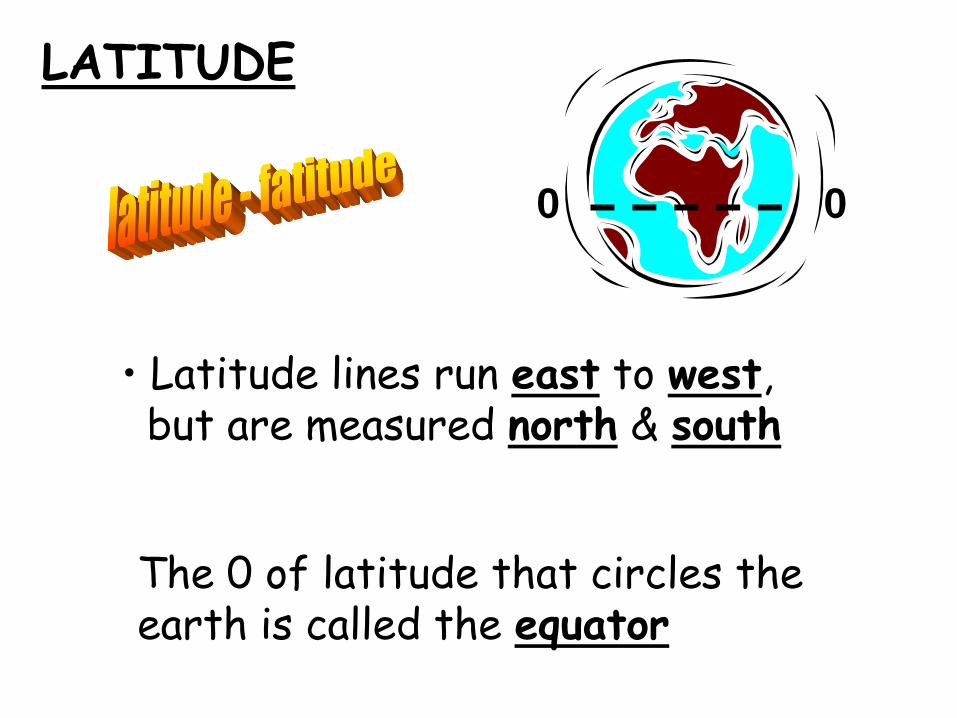
LATITUDE
• Latitude lines run ____ to ____, but are measured _____ & _____
The 0 of latitude that circles the earth is called the _______?
LATITUDE
• Latitude lines run east to west, but are measured north & south
The 0 of latitude that circles the earth is called the equator
0 0

LONGITUDE
Longitude lines run _____ to _____,but are measured ____ and ____
The 0 line of longitude that extends from the _____ to the_____ Poleis called the _______ _______

LONGITUDE
Longitude lines run north to south,but are measured east and west
The 0 line of longitude that extends from the North to the South Poleis called the Prime Meridian
0
0

KWAKIUTL

KWAKIUTL
• Northwest/Coastal Range
salmon(food) platform house
w/totem pole
• Rainy but mild climate

KWAKIUTL

KWAKIUTL
fisherman(economy)
Canoetransportation

SIOUX/LAKOTA

• Great Plains
Buffalo(food)
Teepee(homes)
• Dry grass land
SIOUX/LAKOTA

SIOUX/LAKOTA

Horses(transportation)
• nomadic• hunters(economy)
SIOUX/LAKOTA

IROQUOIS

IROQUOIS• Eastern Woodland• Appalachian Mtn.• Coastal Plain
wigwam/longhousehomes
corn, beans, squash(3 sisters) deer

IROQUOIS
Family subgroup:•
•
•
•
•
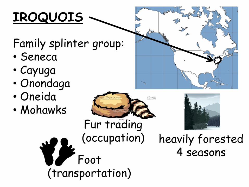
IROQUOIS
Family splinter group:• Seneca • Cayuga• Onondaga• Oneida• Mohawks
heavily forested4 seasons
Foot(transportation)
Fur trading(occupation)

INUIT

INUIT• Canadian Shield• Arctic Circle• Alaska & Canada• very cold/snow & ice
Igloo(homes)
Seal&whale
(food)

INUIT

INUIT
Hunting/fishing(economy)
Dogsled&
Kayak
(transportation)

PUEBLO

PUEBLO
• Basin & Range• southwest• New Mexico/Arizona• desert-hot/dry
pueblo/hogan(homes)
Corn=maize(food)

PUEBLO

PUEBLO
Horse(transportation)
Herdsmen, traders(economy)

AMERICAN INDIANS
NATURAL RESOURCES

AMERICAN INDIANS
NATURAL RESOURCES
forest animal/animal skins
fishice/water
(shelter) (food & clothing)

BERINGIA

BERINGIA
Land bridge that allowed Asians to follow herds (migrate) into North America

COLORADO RIVER

COLORADO RIVER
• This river was explored by the
Spanish & runs through the
Grand Canyon

RIO GRANDE RIVER

RIO GRANDE RIVER
• Forms a border with Mexico

COLUMBIA RIVER

COLUMBIA RIVER
• Explored by Lewis & Clark

OHIO RIVER
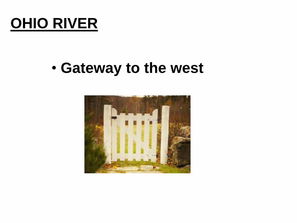
OHIO RIVER
• Gateway to the west

MISSISSIPPI & MISSOURI RIVERS

MISSISSIPPI & MISSOURI RIVERS
• “The transportation arteries for farm
and industrial products.
• Links to ports and other parts
of the world

Gulf of
Mexico
GULF OF MEXICO

GULF OF MEXICO
• Provided the French & Spanish with
exploration routes to Mexico
and parts of America
12
3
4
5
1-Lake Superior
2-Lake Huron
3-Lake Ontario
4-Lake Michigan
5-Lake Erie
Pacific
Ocean
Atlantic
Ocean
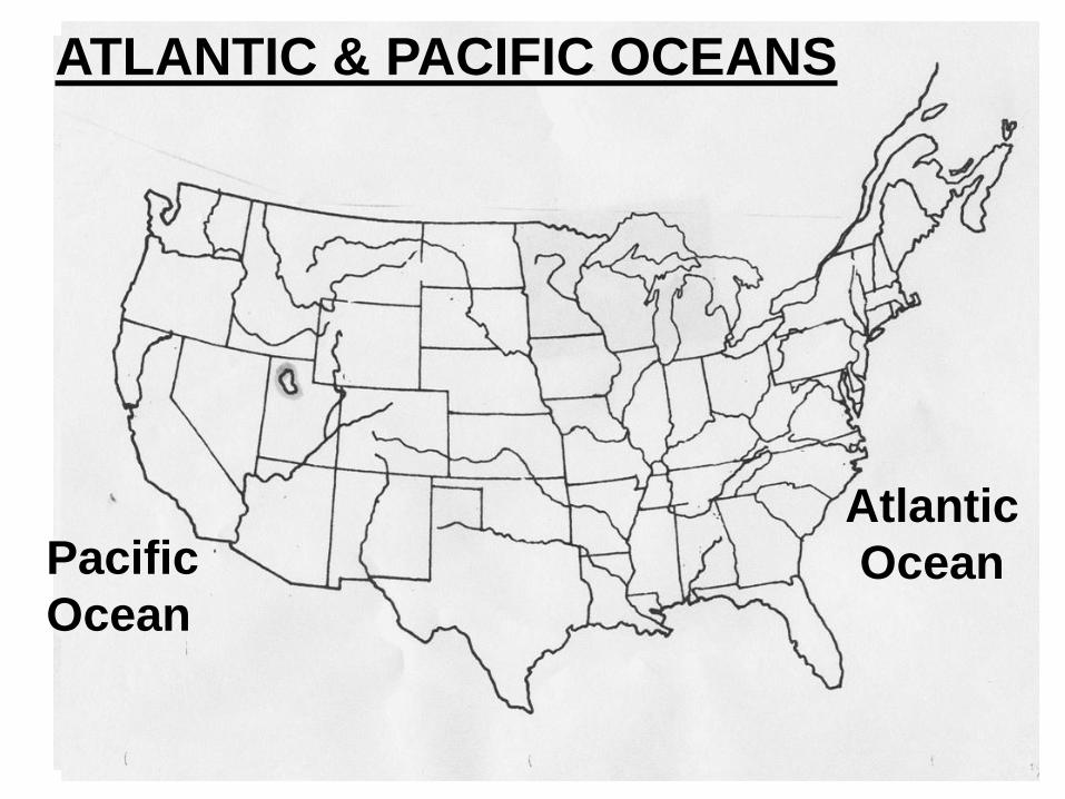
ATLANTIC & PACIFIC OCEANS

ATLANTIC & PACIFIC OCEANS
• Atlantic Ocean – served as the
highway for explorers, early
settlers, & later immigrants


• The location of the United States,
with its Atlantic and Pacific Coasts,
has provided access to other
areas of the world
• America’s waterways have been
important for trade, transportation
and settlement
FACTS TO KNOW:

ST. LAWRENCE RIVER
St. Lawrence River

ST. LAWRENCE RIVER
• Forms part of the NORTHEAST border
with CANADA and connects the
GREAT LAKES to the ATLANTIC
OCEAN
CANADA
St. LAWRENCE RIVER
ATLANTIC
OCEAN
U.S.

St. Lawrence River
Hudson River
ST. LAWRENCE & HUDSON RIVERSLake Superior
Lake Huron
Lake Ontario
Lake Michigan
Lake Erie
GREAT LAKES

GREAT LAKES
• Inland port cities grew in the Midwest
along the Great Lakes

COASTAL PLAIN

COASTAL PLAIN
Location: along theAtlantic Ocean & Gulf of Mexico
Physical Characteristics: broad lowlandproviding many excellent harbors

APPALACHIAN MOUNTAINS

APPALACHIAN MOUNTAINS
Location: west of the Coastal Plain; extends from eastern Canada to westernAlabama
Physical Characteristics: old eroded mountains—oldest mountainrange in North America

CANADIAN SHIELD

CANADIAN SHIELD
Location: wraps around the Hudson Bay in ahorseshoe shape
Characteristics: worn by erosion & hundreds of lakes carved byglaciers; some of the oldest rock formations in North America

INTERIOR LOWLANDS

Location: west of theAppalachian Mountains &east of the Great Plains
Characteristics: rolling flatlands with many rivers, broad river valleys, & grassy hills
INTERIOR LOWLANDS

GREAT PLAINS

GREAT PLAINS
Location: west of the Interior Lowlands & eastof the Rocky Mountains
Characteristics: flat land thatgradually increases in elevation as you go west; it has grasslands

ROCKY MOUNTAINS

ROCKY MOUNTAINS
Location: west of the Great Plains & east of theBasin & Range
Characteristics: rugged mountains stretching from Alaska to Mexico with high elevations; contains the Continental Divide-which determines the flow of rivers

BASIN & RANGE
ex. of basin

BASIN & RANGE
Location: west of the Rocky Mtns., east of the Sierra Nevada Mtns., & theCascade Mtns.
Characteristics: an area of different elevations containing isolated mountain ranges and Death Valley, the lowest point in North America

COASTAL RANGE
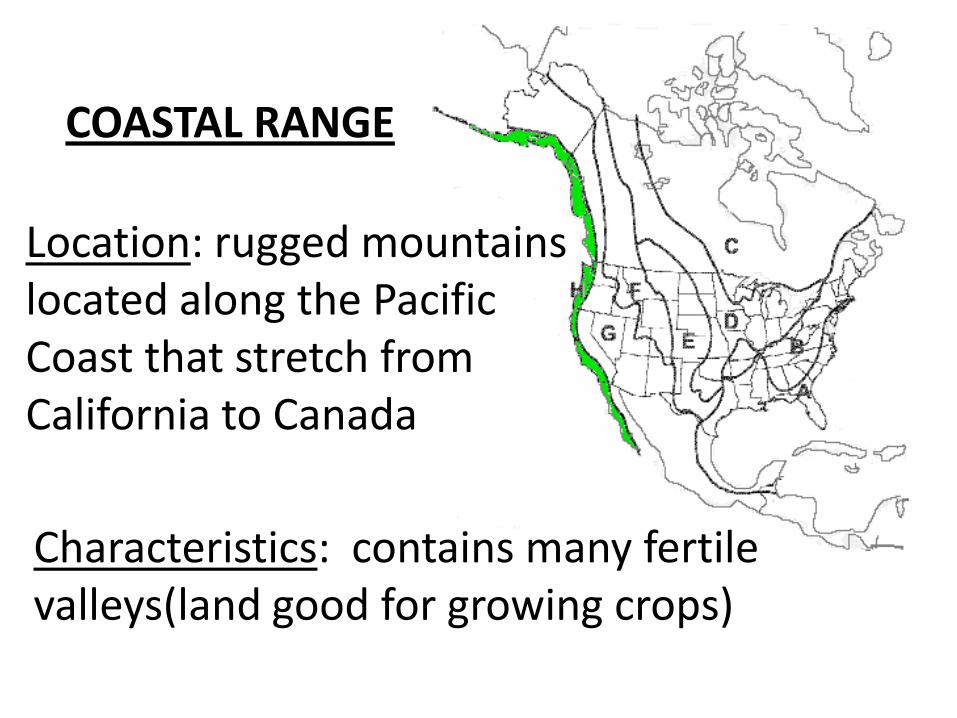
COASTAL RANGE
Location: rugged mountains located along the Pacific Coast that stretch from California to Canada
Characteristics: contains many fertile valleys(land good for growing crops)

Name the 7 continents & 5 oceans
1
2
3
4
5
6
7
A B
C
D
A
E

PacificOcean
AtlanticOcean
ArcticOcean
IndianOcean
South Ocean