landscape and visual impact assessment december 2013
TRANSCRIPT
CHIPPING
LANDSCAPE AND VISUAL IMPACT ASSESSMENT
December 2013
Undertaken by Camlin Lonsdale Landscape Architects for and on behalf of
53N Bowland Ltd

619 Chipping ii Landscape and Visual Impact Assessment 131211
619 Chipping iii Landscape and Visual Impact Assessment 131211
CONTENTS
Executive summary
1. Introduction 1
1.2 Description of proposed development 1
2. Approach 3
3. Landscape Effects 4
3.1 Baseline conditions 4
3.2 Landscape context 6
3.3 Designations 6
3.4 Evolution over time 7
3.5 Landscape character within the site 9
3.6 Assessment of landscape effects 11
3.7 Overall importance of landscape effects 16
3.8 Conclusions 18
4. Visual effects 19
4.1 Baseline Conditions: Visual 19
4.2 Assessment of visual effects 20
4.3 Magnitude of visual effects 23
4.4 Importance of effects on visual amenity 23
4.5 Mitigation measures 25
4.6 Conclusions 26
APPENDIX 1: Methodology 28

619 Chipping iv Landscape and Visual Impact Assessment 131211

619 Chipping v Landscape and Visual Impact Assessment 131211
EXECUTIVE SUMMARY This report was prepared by Camlin Lonsdale landscape architects to assess the landscape
and visual effects associated with the hybrid planning application for various development
areas within the village of chipping. A Landscape and Visual Impact Assessment is a tool
used to identify and assess the importance of effects of change resulting from developments
in both the landscape as an environmental resource in its own right and on people’s views
and visual amenity. Identification of the anticipated effects enable a sensitive design
response, ensuring its positive integration with the surrounding landscape fabric.
Landscape and Visual Impact Assessments are separate, although linked procedures.
Landscape effects derive from change in the physical landscape, which may give rise to
changes in the landscape resource. Hence appraisal of landscape effect is concerned with
direct effects on specific landscape elements and more subtle effects on the overall pattern
of elements that give rise to landscape character and local distinctiveness.
Visual ef fects relate to the changes that arise in the composition of available views as a
result of changes to the landscape elements of the site. Therefore the appraisal of the visual
effect will be concerned with the effect of the development on views of the site, and the
sensitivity of viewers who may be affected by these changes.
The proposed development areas, comprising tourism and leisure facilities, residential and
employment uses and a new village cricket ground, are set in various locations within the
village. Most development is concentrated to the derelict, former chair making factory site to
the north of the village.
Chipping is an attractive village, retaining much of its historic vernacular character in the
centre of the village, is set within the Undulating Lowland Farmland character area to the
south of the Forest of Bowland Area of Outstanding Natural Beauty. Historically the village
marked an important agricultural trading point and with the abundant water supply
flourished industrially with seven water powered mills being recorded in the valley in the mid
twentieth century. More recently the village was dominated by the Berry Joinery and Chair
making business which occupied Kirk Mill and the adjacent modern factory buildings to the
north of the village.
619 Chipping vi Landscape and Visual Impact Assessment 131211
The overall settlement of the village remained constant until the 1950’s when it expanded
northwards (Kirklands and Broad Meadow) and south westwards along Windy Street and
subsequently southeastwards (Brooklands).
The assessment has determined that the landscape character of the study area is generally
of moderate to high sensitivity and to be predominantly moderate value. The overall
importance of landscape effects arising from the proposed development at Day 1 is
expected to be minor adverse in most parts of the development area whilst in the Kirk Mill
and modern factory site it is expected to be Major Beneficial effect. The overall effect on
the Forest of Bowland Area of Outstanding Natural Beauty (AONB) is expected to be
negligible.
The long term visual effect, once the new planting has established, is considered to be
generally of Minor Beneficial to Major Beneficial importance with the development
associated with Kirk Mill and the modern factory site redevelopment.
The development will sympathetically incorporate new uses within the listed Kirk Mill and
replace the large scale industrial sheds with buildings of more appropriate scale and form
which will enhance the setting of Kirk Mill and its associated conservation area. The
provision of areas of high quality public realm will improve the setting of Chipping Brook and
allow public access to the riverside.
Areas of residential development on higher ground to the north of the village are more
visually exposed at the outset of the development but will soften over time with the
establishment of the associated landscape planting, aiding its integration within the wider
rural landscape.
The development provides the opportunity to introduce additional tree and shrub planting,
aiding the integration of the developments within the locally well wooded landscape and
enhancing the visual quality of the popular, much visited local landscape.
619 Chipping 1 Landscape and Visual Impact Assessment 131024
1. INTRODUCTION
1.1.1 This report, prepared by Camlin Lonsdale landscape architects, assesses the landscape and visual effects of the proposed development at Chipping in Lancashire. The 2013 GVLIA3 guidelines defines a Landscape and Visual Impact Assessment (LVIA) as a tool used to identify and assess the importance of effects of change resulting from developments in both the landscape as an environmental resource in its own right and on people’s views and visual amenity.
1.1.2 The report indicates the methods used to assess the baseline conditions currently existing at the site and surroundings and the potential direct and indirect effects of the development arising from changes to landscape components and views. It identifies mitigation measures available to reduce or offset the effects and assesses the importance of long term residual effects.
1.1.3 In accordance with GVLIA3 this report distinguishes between the ‘impact’, defined as the action being taken and the ‘effect’, defined as the change resulting from that action.
1.2 Description of proposed development
1.2.1 The proposed development will comprise tourism and leisure facilities, residential and employment uses and a new cricket pitch and pavilion in keeping with the land uses in the surrounding landscape.
1.2.2 A hybrid planning application comprising the following elements has been used as the basis of the LVIA.
• Demolition of former industrial buildings, Removal of the more modern large scale industrial buildings associated with the former chair making factory.
• Outline permission for the erection of 4 residential units, with all matters other than for scale and access reserved. It has been assumed that these buildings will be similar in height and materials to the local vernacular.
• Outline permission for the erection of 55 residential units, with all matters other than access reserved. It has been assumed that these buildings will be similar in height and materials to the local vernacular.
• Full permission for the conversion and erection of buildings to provide a hotel pub/restaurant and leisure complex on former industrial land. The details of these buildings are described in more detail in the architectural proposals submitted as part of the planning application.
• Full permission for a new access route, car parking facilities and a trail head centre on former industrial land. The details of these buildings are described in more detail in the architectural proposals submitted as part of the planning application.
• Full permission for a new cricket pitch, pavilion, parking facilities and vehicular access on land to the south of the village.
619 Chipping 2 Landscape and Visual Impact Assessment 131024
Potential Impacts 1.2.3 The key potential landscape and visual impacts presented by this development are
identified below:
• Removal of built form within the landscape • Loss of existing vegetation • Changes to existing landform • Introduction of new elements, including built form into the landscape • Effect on views from properties and publicly accessible land within the immediate
vicinity of the site. • Visual effects on the character and appearance of the local area
Primary mitigation measures 1.2.4 Measures to mitigate any visual effects, enhance the village and landscape value and
improve visual quality of the area are integral to architectural and landscape design work. Primary mitigation measures are those identified as an integral part of the scheme and would definitely be implemented. They include the approach to layout, massing, materiality and the grain of the development together with planting to aid the integration of the proposed development within its surroundings.
1.2.5 The following primary mitigation measures have been identified for the detailed planning application areas:
• Short term (during the demolition and construction phases) screening such as site hoardings to minimise temporary visual effects
• Placement and orientation of new structures within the landscape • Form and material of proposed structures • Potential to screen views at source • Appropriate external setting for buildings within the Kirk Mill Conservation Area • Comprehensive landscape planting, using predominantly locally indigenous species
to aid integration with and enhancement of the key characteristics of the landscape character area in which the development is positioned
1.2.6 The areas currently only developed to an outline stage are assessed without specific mitigation. Suitable mitigation measures are identified in section 4.4 and would be included in any subsequent design parameters set for the development of more detailed proposals for these areas.

619 Chipping 3 Landscape and Visual Impact Assessment 131024
2. APPROACH
2.1.1 The identification of potential landscape and visual effects is important in order to establish appropriate mitigation measures to reduce temporary effects of the development during construction and to aid its integration with the surrounding landscape fabric in the longer term. Landscape and visual impact assessments are separate, although linked procedures.
2.1.2 Landsc ape ef f ects derive from changes in the physical landscape, which may give rise to changes in the landscape resource. Hence appraisal of landscape effect is concerned with direct effects on specific landscape elements and more subtle effects on the overall pattern of elements that give rise to landscape character and local distinctiveness.
2.1.3 It will determine the degree to which the existing landscape will be affected both directly and indirectly by the proposed development in terms of its current value and its sensitivity to change. The capacity of the landscape to accept change of the type and scale proposed is dependent on the form of development, rather than an intrinsic attribute of the landscape.
2.1.4 The value of the landscape receptors is based on an assessment of landscape designations and whether the receptor is valued locally; it is not dependent on the form of the development. Value of landscape receptors has been defined in Appendix 1.
2.1.5 Visua l e f f ec ts relate to the changes that arise in the composition of available views as a result of changes to the landscape elements of the site. Therefore the appraisal of the visual effect will be concerned with the effect of the development on views of the site, and the sensitivity of viewers who may be affected by these changes.
2.1.6 It will determine the magnitude of change in the view based on the following considerations. Magnitude of change has been defined according to rating definitions in Appendix 1.
• The degree of contrast between new and existing features in terms of form, scale and mass, line, height colour and/or texture
• The angle of view • The proportion of the view that would be occupied by the development • The distance of the viewpoint from the development • Whether the development would be the focal point or one element of the view. • Whether there is seasonal change due to differences in screening.
2.1.7 The methodology for undertaking the Landscape and Visual Assessment follows the guidelines set out in the third edition of Guidelines for Landscape and Visual Impact Assessment (GLVIA) (Landscape Institute and Institute of Environmental Management and Assessment, 2013).
2.1.8 Given the timing of the site visit and the late spring experienced this year (2013), the majority of native vegetation was still in its dormant stage, enabling the worst case scenario visual effects to be assessed.
Assumptions / Limitations 2.1.9 The following limitations were experienced during the production of this report:
• As it was not possible to experience first hand views from private dwellings the assessment made from these locations are assumed only.
• Primary mitigation measures have been included and are assessed as part of the detailed planning application areas. Mitigation measures for the outline planning applications areas are identified as secondary mitigation as they can not be assumed to be included in a subsequent detailed planning applications.
619 Chipping 4 Landscape and Visual Impact Assessment 131024
3. LANDSCAPE EFFECTS
3.1 Baseline conditions
3.1.1 This section describes the baseline landscape conditions within the study area. It provides a understanding of the landscape constituents within the area of proposed development together with its character, its history, its condition, the way in which the landscape is experienced and the value that is attached to it.
Site location and study area 3.1.2 The development site is located to the immediate north of the village of Chipping
concentrated on and within the vicinity of the former chair making factory. A new cricket ground is proposed to the immediate south of the village adjacent to Chipping Brook. The study area represents the area within which the proposed development may affect landscape character as well as the development site itself. It encompasses the local Zone of Visual Influence.
National landscape character context 3.1.3 The study area falls within the National Landscape Character Area 33 – Bowland Fringe
and Pendle Hill. Key characteristics applicable to the study area are:
• This is an undulating, rolling landscape, with local variation created by numerous river valleys and by the moorland outliers of Beacon Fell, Longridge Fell and Pendle Hill.
• The Bowland Fells provide a dramatic backdrop to the north, with extensive views across the river valleys and Lancashire plain below.
• On the northern edge of the area, drumlins are characteristic, while on the south, strong mounded outcrops or ‘reef knolls’ of limestone form distinct landscape features in the Ribble and Hodder valleys.
• Semi-natural woodland, much of which is ancient, occurs in the main valley bottoms, side valleys and ridges, and is dominated by oak, ash and alder.
• Small- to medium-sized fields are defined by hedgerows with mature hedgerow trees. Drystone walls are also common in some areas. Metal railings around estate boundaries and highway corners and junctions are characteristic of the southern and western edges of the NCA.
• Land use is mainly permanent, improved pasture for livestock and dairy farming. • There are species-rich hay meadows, including several that are nationally and
internationally designated. • Rough grazing, rushy pasture and traditionally managed meadows at higher
elevations are of national importance for breeding waders such as redshank, lapwing, curlew and snipe. These are also important habitats for breeding skylark.
• There are numerous rivers of importance for many protected species, including bullheads, salmon, trout, eels, otters, kingfishers and dippers. There are also many brooks and small reservoirs.
• There are many archaeological sites, particularly on the moorland fringes and in valleys where agriculture has been less intensive.
• A network of winding, hedge-lined lanes connects small, often linear, villages, hamlets and scattered farmsteads, mostly in local stone. Traditional stone barns are commonplace on higher ground, and are of stone with slate or stone flag roofs.
• Isolated country houses set in formal parkland are typical of the area, and may be enclosed by belts of woodland and estate fencing.
619 Chipping 5 Landscape and Visual Impact Assessment 131024
Local landscape character context 3.1.4 Lancashire County Council includes the study area within the ‘Undulating Lowland
Farmland’ in its ‘A Landscape Strategy of Lancashire - Landscape Character Assessment’. Its key landscape characteristics are:
• Generally below 150m, lying between the major valleys and the moorland fringes. • Underlying geology is largely masked by heavy bolder clays. • Hedgerows predominate over walls. • Lowland landscape is traversed by deeply incised wooded cloughs and gorges. • Many mixed farm woodlands, copses and hedgerow trees, creating an impression
of a well wooded landscape • Some of the most picturesque stone villages of the county occur within this well
settled landscape type. • The area contains many country houses whose boundary walls and designed
landscapes add to the species diversity and visual appeal. • High density of farms and scattered cottages outside the clustered settlements
linked by a network of minor roads.
3.1.5 This broad area is further subdivided with the site area falling within Local character area 5B, Lower Hodder and Loud Valley, with the following description:
“This area forms part of the Undulating Lowland Farmland to the south of the Forest of Bowland and includes the deeply incised wooded course of the Hodder below Witewell and its tributary, the River Loud, as far as its confluence with the Ribble. The underlying bedrock is limestone which is overlain by good soils, providing lush green pastures and good tree growth. The course of the Hodder is particularly well wooded and the pattern of incised minor wooded tributaries is distinctive to this character area. The area is little affected by modern development and the picturesque limestone villages of Chipping and Waddington have retained their vernacular character.”
3.1.6 The study area displays a number of these characteristics, but is not completely representative of this Landscape Character Area, as it has experienced significant modern residential and industrial development concentrated in the later half of the last century.

619 Chipping 6 Landscape and Visual Impact Assessment 131024
3.2 Landscape context
Landform and drainage 3.2.1 The topography of the study area is predominantly rolling land, crossed by steep sided
stream valleys. Land varies from around 100m AOD in the wide valley floor, rising to over 200m AOD as it rises towards Parlick and Fair Snape Fell 4km (2.5 miles) to the north of the village of Chipping. The development area ranges from 100m to 130m AOD. Ground is seasonally waterlogged in localised low lying areas. Chipping Brook forms the largest watercourse within the study area, set in a northwest/ southeast orientation. To the north of the study area it is contained within a narrow, steep sided valley. The point at which the main contributory (Dobson’s Brook) converges with Chipping Brook, immediately north of the Kirk Mill pond, the valley form widens before it meets the main valley floodplain to the east of the study area. The landform has strongly influenced the historic settlement pattern of the study area.
Land cover and land use 3.2.2 Land within the study area is predominantly pastoral agriculture supporting cattle and
some sheep. The field size is small to medium and contained largely by well maintained dense hedgerows although hedgerow trees are limited to localised areas within the study area. The steeply incised stream valley sides support native and planted stands of broadleaved woodland, which together with planned parkland landscape of the Leagram estate and small woodland copses leads to the impression of a well wooded landscape.
3.2.3 Small farmsteads occur evenly distributed across this well settled landscape. To the north the intact landscape and buildings associated with the Leagram estate form a locally distinctive landscape feature. The historic core of the village of Chipping is set within the mouth of the Chipping Brook valley as it emerges from its steeply incised watercourse to the north. More recent residential development has extended build form onto more elevated land to the north west of the historic core. The villages long association with industry is still evident with the derelict buildings associated with the former chair making factory which is concentrated on the low lying land between Kirk Mill and the Chipping Brook bridge.
3.3 Designations
3.3.1 The site is positioned to the south of the Forest of Bowland Area of Outstanding Natural Beauty (ANOB).
3.3.2 There are a number of Public Rights of Way that traverse the study area. They are predominantly footpaths and a small number of bridleways. The footpaths are generally short in length, providing links across fields between the scattered farmsteads.
3.3.3 Kirk Mill Conservation Area was established in 2010 to preserve the setting of the listed mill building, its associated buildings and mill pond.
3.3.4 There are a number of important buildings within the immediate vicinity of the proposed development site including Kirk House, two cottages on Church Raike, the Church of St Bartholemew and much of Talbot Street. Kirk Mill, its millponds retaining walls, outflow and stone built leat are also Listed. Leagram Hall lies to the north east of the study area and is typical of the country estates noted as characteristic of the local landscape character area.
619 Chipping 7 Landscape and Visual Impact Assessment 131024
3.4 Evolution over time
The evolution of the landscape 3.4.1 Information from the Chipping Local History web site indicates the name “Chipping” is
derived from the Old English “ceping”, meaning “a market”. The market developed near the bridge over Chipping Brook positioned at the entrance to the Royal Forest of Bowland which was located to the east of the village. To the west of Chipping, outside Forest control, the land was divided into private manors and was consequently more populated and more visually diverse. The Chipping market was at a point of exchange between the two different economies and was a major outlet for the Bowland cattle farms. The last livestock markets in Chipping were sheep sales, at the back of a local public house The Talbot, in the 1950s.
3.4.2 By-trades were always important sources of extra income in the farming households, for example, cheese making, wood and leather working and especially textiles. Many of the By-trades have regained importance in recent years with many high quality local products now being recognized nationally. Spinning and handloom weaving of wool and flax became increasingly important in the late 17th and 18th centuries.
3.4.3 Chipping flourished industrially when the waterpower of the district was fully developed. By the mid 19th century, there were seven water-powered mills on Chipping Brook. More recently the village has been dominated by the Berry Joinery and chair making business which occupied Kirk Mill and the adjacent modern factory scale buildings and employed a significant number of people from the village.
3.4.4 The settlement has evolved over time reflecting the increasing population associated with the industrial activities of the area. The 1892/93 OS map of the area shows three discrete areas of residential development. The largest centred on the historic crossing point of Chipping Book with the main area of settlement lying to the south of Talbot Street. To the north the small hamlet of Old Hive is evident and a small cluster of buildings around Kirk Mill.
3.4.5 The settlement pattern remained like this until the postwar period, with the 1933 OS plan showing no significant change to the settlement pattern. The 1956 OS plan for the area shows the initial built development associated with the Kirklands estate, with a new area of housing shown to the north west of Church Raike. This map also shows new residential development to the south of the village to the immediate west of Windy Street.
3.4.6 The 1987 OS plan shows no further development, indicating the western area of the Kirklands estate and the recent residential development to the south of the village (Brooklands) was constructed after this period.
619 Chipping 8 Landscape and Visual Impact Assessment 131024
3.5 Character areas within the immediate vicinity of the development area
3.5.1 A number of discrete local landscape character areas can be identified within the landscape surrounding the proposed development area. Elements within this area are typical of Lower Hodder and Loud landscape character area identified within the Landscape Character assessment of the area prepared by Lancaster County Council.
• Chipping Village Historic core: The picturesque limestone village centre of Chipping is noted as retaining its vernacular charm in the Lancashire County Council Landscape Character Assessment. The historic core, concentrated on Talbot Street and Windy Street has changed little from the late nineteenth century and the narrow streets bound by a mixture of limestone buildings attracts many visitors. Planting within the area is limited. Views focus on the main circulation corridors and to the church of St Bartholomew, positioned to the north east of the junction between Talbot Street and Church Raike. Twentieth century expansion: A significant village expansion, concentrated on higher ground to the north west of the village occurred in the mid twentieth century, comprising areas known as Kirklands, Kirkfield and Broad Meadow. The housing type and estate layout are much more uniform creating a bland, somewhat incongruous character with little attempt to positively integrate the area with the historic core. There is limited planting within the public realm, which is dominated by roads, pavements, and parking areas.
• Surrounding farmland
Small to medium sized fields enclosed by hedgerows and some standard trees occur to the north and west of the development area. A larger, more degraded field system associated with the wide valley floor landscape occurs to the south of the village. Farmsteads and small hamlets, such as Old Hive, are evenly distributed across the well settled landscape and are noted as a typical characteristic of the wider character area.
• Steep wooded cloughs A steep sided introspective wooded valley occupies land to the north west of the village and contains a narrow local access route. The interface with the road is formed predominantly by a thin hawthorn hedge that has been laid in the past. The bend in the road, which accommodates a bend in the brook corridor is retained by a stone wall with metal estate railings above. A number of small introspective commercial and residential developments, such as Tweddys Court, occur within this wooded landscape. A second, steep sided wooded clough, known as Nan King’s Wood, containing the Dobson Brook water course runs north from the Kirk mill pond. This type of landscape is a typical feature of the Undulating Lowland Farmland landscape character identified in A Landscape Strategy for Lancashire – Landscape Character Assessment.

619 Chipping 9 Landscape and Visual Impact Assessment 131024
• Leagram Estate The hall, estate buildings and remnant parkland/designed landscape occupies land to the north east of the village. Principle views orientate southwestwards, away from the village and all buildings are heavily screened from the village and the Chipping Brook Clough by substantial mature plantations. With the exception of Leagram Lodge and the adjacent estate entrance gates the boundary of the estate is generally not marked by boundary walls or estate railing. An ornamental shelter belt occurs to the north of the local access road off Talbot Street/Green Lane.
3.6 Landscape character within the site
3.6.1 The various zones of development form a number of distinct areas each exhibiting their own particular site attributes and characteristics as described below.
• Kirk Mill Conservation Area The rich history and architectural elements remaining within the Kirk Mill area have
recently been recognised by the designation of the Kirk Mill Conservation Area. Kirk Mill, an early example of an Awkright type cotton mill, forms the centrepiece of the area. The Kirk Mill footprint occupies a condensed section of land and due to the industrial activity that occurred within its curtilage, does not have any prominent trees within its immediate vicinity. It is closely associated, both culturally and physically with the adjacent water course.
Three locally important, over mature horse chestnut trees and a mature yew tree
are positioned to the south of Chipping Brook between the mill and the access track to The Grove and Kirk House. These trees lay outwith the development boundary and are recommended for removal in the arboriculturalist report, but they contribute positively to the overall setting of the Mill, especially in views north along Malt Kiln Brow.
• Modern factory site The largest development area occupies the site of the former Berry Chair making
factory site. It is a low lying, visually introspective brown field site comprising a range of buildings from historic stone built barns associated with the Kirk Mill complex to large scale modern industrial buildings that pay little respect to the scale and sensitivity of their landscape setting. The northern aspect of this area lies within the Kirk Mill Conservation Area. There is currently no public access to this riverside location.
Within the developed area of this plot, trees are generally restricted to
opportunistic self seeded locally indigenous species that have colonised sections of the river banks and steeply sloping interface with Malt Kiln Brow/Church Raike to the south west and to a lesser extent the boundary with the rural parkland of the Leagram estate to the north. Species are typically ash, oak, alder (river banks) and sycamore. These trees are not of great importance on an individual basis but do currently perform the beneficial role of filtering views of the large scale industrial units from Malt Kiln Brow.
Built form is industrial in nature and scale. Materials of the buildings are
predominantly brick with some rendered facades. Buildings at the entrance to the site are clad in a profiled sheet metal. A large scale open aspect concrete framed shed is positioned to the south east of the area. Roofs comprise profiled asbestos sheets with the exception of the slate roof associated with the older stone building to the north east of the site.

619 Chipping 10 Landscape and Visual Impact Assessment 131024
The majority of the ground surface is covered in various sized slabs of in situ concrete. Much of the river corridor is contained within engineered channels, bound by substantial concrete walls. Overhead gantries and the large scale industrial buildings further compound the man made dominance over the potentially attractive natural elements of the site.
• Malt Kiln House field A field to the immediate west of Malt Kiln House encompasses a well defined
topographical spur. A flat area of land more closely associated with the group of houses known as Old Hive drops away sharply to accommodate the two water courses (Chipping Brook to the north and a small stream to the south of the field). This topographical feature creates a strong sense of enclosure around the cluster of buildings at the base of the hill within the Kirk Mill Conservation Area and as such is recognized by its inclusion within the designation.
The grassland has not been intensively farmed. Tree planting is confined to the
edges of the field with the most extensive area occurring on the steep bank adjacent to the road. This supports a stand of mature deciduous trees including sycamore, ash and oak typical of the wooded cloughs identified as a typical feature of the Lower Hodder and Loud Valley Character area.
A stone retaining wall forms the boundary with the road corridor to the south
west of the boundary of the field. This structure physically separates it from the elevated highway corridor. A small stream is located to the base of the wall and flows eastwards to join Chipping Brook in the vicinity of the existing factory entrance. The remnant boundary hedge to the west is poorly defined, but contains three visually prominent mature trees (lime, sycamore and ash). Large mature trees of ash and beech occur along the river boundary with The Grove and Kirk House. Informal private access to the field is currently gained via a short track off Malt Kiln Brow. There are no public rights of way across the land.
• Former Cricket Ground An area of land, immediately adjacent to the Kirkfield and Kirklands housing areas
comprises a semi improved field which supported the village cricket pitch and an area of juvenile deciduous woodland. The currently unmanaged grassland is bound by traditional native hedges and isolated mature standard trees (ash) to the north and east. An over-grown hedge/mature trees occur along the boundary to the upper section of the Kirkland Estate and the private residential unit called The Field. The access track (Footpath No FP 97) to The Field, to the north west and out-with the development area is bound by an avenue of locally distinctive mature poplar trees. The area of land to the east of the field has been recently densely planted with a predominantly deciduous woodland mix. The dominant species appear to be birch and hazel. The ground flora retains remnant grassland species from its former use as pastureland. The original boundary hedge between this newly planted area and the Kirkland estate is still maintained although shows signs of breaching in a number of locations. The eastern boundary of the development area is not defined on the ground.
A small single storey derelict looking pavilion building is positioned to the south
west of the field, close to the northern boundary with the Kirkfield Estate. There are no official rights of way across the land although informal use of the area of recently planted trees is apparent.
• Field to the south of the village
619 Chipping 11 Landscape and Visual Impact Assessment 131024
A field adjoining Chipping Brook, to the south of the village has been identified to accommodate a new cricket ground for the village. It currently comprises semi-improved, low lying agricultural grassland. Chipping Brook and residential properties bound the western edge of the field. Elsewhere boundaries are formed of remnant broken lengths of hedgerow and post and wire fencing. A small number of mature trees occur along the boundaries to the field and within the Chipping Brook corridor.
Access to the field is gained via a narrow stone bridge off Longridge Road to the
south of Town End Barn. The bridge is currently obscured by semi-mature, self seeded vegetation. It forms the start point for a number of local footpaths (FP7, 8 & 30) that traverse this low lying landscape.
3.7 Assessment of landscape effects
Sensitivity of the landscape resource 3.7.1 As noted previously sensitivity is assessed by the degree to which a particular landscape
type or area can accommodate the change arising from the proposed development. The assessment of sensitivity is dependent on the form of development, rather than an intrinsic attribute of the landscape. Sensitivity and value rating definitions are contained within Table Ap 1.1
3.7.2 Table 3.1 lists the sensitivity and value ratings for landscape elements identified for each of the character areas within the proposed development area. It identifies the changes expected to each landscape receptor as a result of the development identified for each area. Following this an evaluation of the magnitude of change to the landscape receptor has been undertaken, with the extent, duration and reversibility of the intervention noted. Finally an overall assessment of the importance of the proposed intervention to each landscape element is provided.

619 Chipping 12 Landscape and Visual Impact Assessment 131024
Table 3.1: LANDSCAPE EFFECTS Character area 1: Kirk Mill – Proposed hotel and leisure accommodation
Landscape receptor Sensit i v ity Value Changes to landscape receptor Magnitude Extent Durat ion Revers ibi l i ty Importance Existing landscape elements Historic listed mill building High High Mill building restored Large beneficial Immediate setting Long term Permanent Major beneficial Security fencing Low Low Industrial scale palisade security fence removed enabling direct views to the mill building Large beneficial Immediate setting Long term Permanent Major beneficial New elements introduced Site hoardings Introduced Introduced Temporary screening of the site works during construction Small adverse Immediate setting Short term Yes Moderate beneficial New public realm Introduced Introduced Setting of building enhanced through sympathetic public realm improvements Large beneficial Immediate setting Long term Permanent Major beneficial Tree planting Introduced Introduced Two trees added to ensure the continuity of tree cover within the setting of the building Medium beneficial Immediate setting Long term Permanent Moderate beneficial
Character area 2: Modern Factory Buildings – Proposed leisure facilities, new access route, car park area and trail head centre
Landscape receptor Sensit i v ity Value Changes to landscape receptor Magnitude Extent Durat ion Revers ibi l i ty Importance Existing landscape elements Industrial buildings Low Low Removed. Stone barn to north east of the development area retained Large beneficial Immediate setting Long term Permanent Substantial beneficial Site boundary fencing Low Low Removed – enhancing visual quality of the site boundary (in particular along Malt Kiln Brow) Small beneficial Immediate setting Long term Permanent Moderate beneficial Concrete bridges Low Low Removed – improving flood control measures and enhancing the visual quality of the river corridor Small beneficial Site level Long term Permanent Minor beneficial Overhead gantry Low Low Removed – enhancing visual quality of the proposed development area Small beneficial Site level Long term Permanent Minor beneficial Concrete surfaces Low Low Retained and incorporated into proposed development. Small beneficial Site level Long term Permanent Negligible Trees High Moderate Loss of small number of trees to accommodate access route and river channel works Small adverse Immediate setting Long term Permanent Negligible Topography High Moderate With the exception of the new access route (see below) – no change to the topography envisaged Negligible Immediate setting Long term Permanent Minor adverse River corridor High Moderate Changes to river channel surface to introduce more natural characteristics Small beneficial Site level Long term Permanent Minor beneficial New elements introduced Site hoardings Introduced Introduced Temporary screening of the site works during construction Small adverse Immediate setting Short term Yes Minor beneficial New buildings Introduced Introduced Introduction of buildings of sympathetic scale, form and materials to their setting Large beneficial Long term Permanent Moderate beneficial Access route Introduced Introduced Prominent new topographical feature
Introduction of lighting elements Medium adverse Minor adverse
Immediate setting Immediate setting
Long term Long term
Permanent Permanent
Minor adverse Minor adverse
New public realm Introduced Introduced Introduction of sympathetic landscape proposals supporting new uses and proposed buildings Medium beneficial Site level Long term Permanent Moderate beneficial Landscape planting Introduced Introduced Range of vegetation types introduced to create distinct character areas and diverse wildlife resource Medium beneficial Immediate setting Long term Permanent Moderate beneficial
Character area 3: Malt Kiln House Field - self build plots (outline application)
Landscape receptor Sensit i v ity Value Changes to landscape receptor Magnitude Extent Durat ion Revers ibi l i ty Importance Existing landscape elements Hedgerows High Low No change Immediate setting Long term Permanent No change Trees High Low All existing trees retained No change Immediate setting Long term Permanent No change Pastureland Moderate Low Agricultural land Medium adverse Immediate setting Long term Permanent Minor adverse Topography High High Access route and re-grading works associated with individual building plots Medium adverse Immediate setting Long term Permanent Minor adverse New elements introduced Site hoardings Introduced Introduced Temporary screening of the site works during construction Small adverse Immediate setting Short term Yes Minor beneficial New buildings Introduced Introduced Location, scale, form and building materials strictly controlled to minimise impact on setting of
conservation area and aid visual integration with surrounding residential areas. Medium adverse Immediate setting Long term Permanent Moderate adverse
Access route Introduced Introduced Formation of new access road requiring substantial associated earthworks Lighting elements potentially incongruous with unlit rural agricultural landscape
Medium adverse Minor adverse
Immediate setting Immediate setting
Long term Long term
Permanent Permanent
Moderate adverse Minor adverse
Landscape planting Introduced Introduced Position and type of planting will aid the integration of the new built form and enhance the visual quality of the local landscape resource
Medium beneficial Immediate setting Long term Permanent Moderate beneficial
619 Chipping 13 Landscape and Visual Impact Assessment 131024
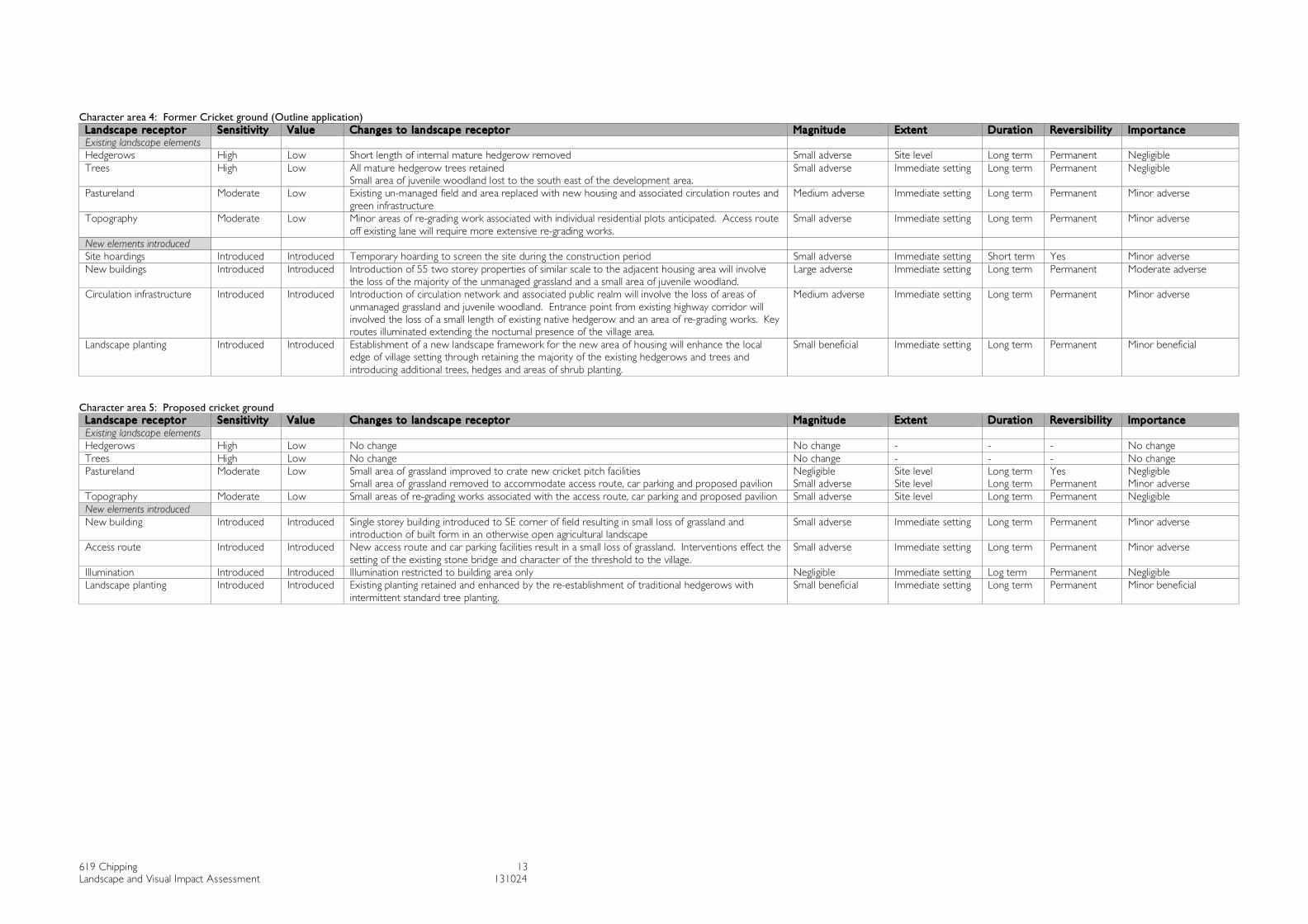
Character area 4: Former Cricket ground (Outline application)
Landscape receptor Sensit i v ity Value Changes to landscape receptor Magnitude Extent Durat ion Revers ibi l i ty Importance Existing landscape elements Hedgerows High Low Short length of internal mature hedgerow removed Small adverse Site level Long term Permanent Negligible Trees High Low All mature hedgerow trees retained
Small area of juvenile woodland lost to the south east of the development area. Small adverse Immediate setting Long term Permanent Negligible
Pastureland Moderate Low Existing un-managed field and area replaced with new housing and associated circulation routes and green infrastructure
Medium adverse Immediate setting Long term Permanent Minor adverse
Topography Moderate Low Minor areas of re-grading work associated with individual residential plots anticipated. Access route off existing lane will require more extensive re-grading works.
Small adverse Immediate setting Long term Permanent Minor adverse
New elements introduced Site hoardings Introduced Introduced Temporary hoarding to screen the site during the construction period Small adverse Immediate setting Short term Yes Minor adverse New buildings Introduced Introduced Introduction of 55 two storey properties of similar scale to the adjacent housing area will involve
the loss of the majority of the unmanaged grassland and a small area of juvenile woodland. Large adverse Immediate setting Long term Permanent Moderate adverse
Circulation infrastructure Introduced Introduced Introduction of circulation network and associated public realm will involve the loss of areas of unmanaged grassland and juvenile woodland. Entrance point from existing highway corridor will involved the loss of a small length of existing native hedgerow and an area of re-grading works. Key routes illuminated extending the nocturnal presence of the village area.
Medium adverse Immediate setting Long term Permanent Minor adverse
Landscape planting Introduced Introduced Establishment of a new landscape framework for the new area of housing will enhance the local edge of village setting through retaining the majority of the existing hedgerows and trees and introducing additional trees, hedges and areas of shrub planting.
Small beneficial Immediate setting Long term Permanent Minor beneficial
Character area 5: Proposed cricket ground
Landscape receptor Sensit i v ity Value Changes to landscape receptor Magnitude Extent Durat ion Revers ibi l i ty Importance Existing landscape elements Hedgerows High Low No change No change - - - No change Trees High Low No change No change - - - No change Pastureland Moderate Low Small area of grassland improved to crate new cricket pitch facilities
Small area of grassland removed to accommodate access route, car parking and proposed pavilion Negligible Small adverse
Site level Site level
Long term Long term
Yes Permanent
Negligible Minor adverse
Topography Moderate Low Small areas of re-grading works associated with the access route, car parking and proposed pavilion Small adverse Site level Long term Permanent Negligible New elements introduced New building Introduced Introduced Single storey building introduced to SE corner of field resulting in small loss of grassland and
introduction of built form in an otherwise open agricultural landscape Small adverse Immediate setting Long term Permanent Minor adverse
Access route Introduced Introduced New access route and car parking facilities result in a small loss of grassland. Interventions effect the setting of the existing stone bridge and character of the threshold to the village.
Small adverse Immediate setting Long term Permanent Minor adverse
Illumination Introduced Introduced Illumination restricted to building area only Negligible Immediate setting Log term Permanent Negligible Landscape planting Introduced Introduced Existing planting retained and enhanced by the re-establishment of traditional hedgerows with
intermittent standard tree planting. Small beneficial Immediate setting Long term Permanent Minor beneficial

619 Chipping 14 Landscape and Visual Impact Assessment 131024
3.7.3 Assessment of the current landscape sensitivity and value of the development site and its immediate environs has been undertaken to determine its consequent capacity to accommodate the proposed development envisaged. The sensitivity rating for each landscape area has been derived from a consideration of the sensitivity ratings of its constituent landscape elements and its standing within its local context. Landscapes whose character is judged to be intact relative to the wider local landscape character and in good condition and where scenic quality, and natural or cultural heritage makes a particular contribution to the landscape are considered of high value. Landscapes that are not distinctive and/or have no features worthy of conservation are considered more tolerant of change and are therefore rated with a lower sensitivity.
• Kirk Mill: Sensitivity: High, Value: High Due to Kirk Mills listed status; its key influence on the surrounding conservation area; its importance in the cultural history of the village and as a visitor attraction the building and its setting is considered of high value to the local landscape and of high sensitivity to change.
• Modern factory site: Sensitivity: Low, Value: Low The derelict large scale industrial buildings form a prominent detracting feature within the local landscape. The condition of the buildings and the associated landscape is poor and the area is not accessible to the public rendering it currently of low value to the local landscape and low sensitivity to change
• Malt Kiln House Field: Sensitivity: High, Value: Moderate A visually exposed field that contributes to the local rural landscape character and the setting of the Kirk Mill Conservation Area. It retains features such as remnant boundary hedges and associated trees and a steep sided partially wooded clough that are noted as typical characteristics of the local landscape. The area is not accessible to the public rendering it currently of limited amenity value. It is however visible from adjacent highway corridors and from private dwellings (the hamlet of Old Hive), and a number of local footpaths increasing its local value to moderate.
• Former cricket ground: Sensitivity: Moderate, Value: Moderate Remnant field hedges and isolated hedgerow trees remain intact however the unmanaged field and juvenile woodland are in poor condition due to their ambiguous use and limited maintenance. Although the area does not contain any designated rights of way informal recreation such as dog walking is apparent. The area is more closely associated with the adjacent village rather than contributing to the character of the rural landscape to the west and north west.
• Field to the south of the village: Sensitivity: Moderate, Value: Moderate Some remnant field hedges and isolated trees remain in tact but contribute little to the surrounding degraded rural agricultural landscape character to the south and east. Many of the field boundaries in this open valley floor have been removed or replaced with post and wire fencing and tree cover is identified as less extensive in the landscape character assessment. The open green space does contribute to the agricultural setting of the village and its position adjacent to residential properties together with the number of footpaths running close to the field renders it a landscape element that is likely to be valued as part of the wider landscape by residents and visitors to the area.

619 Chipping 15 Landscape and Visual Impact Assessment 131024
• Residential development (Kirklands/Kirkfield) Sensitivity: Low Value: Low The adjacent residential area to proposed housing development on the former cricket pitch. The house type and layout of the mid twentieth century housing estate does not demonstrate any local characteristic and does not contain any listed buildings. The overall area does not contribute positively to the agricultural hinterland or the historic village core. The condition of the external environment is poor. The character of the housing that abuts the former cricket pitch is influenced to some extent by the fact that they are located adjacent to ‘open space’. Changes in the adjacent land use from an open field to residential will therefore change the edges of these areas to some degree.
• Historic core: Sensitivity: High Value: High The sensitivity to change has been rated high as the area is highly valued locally and is an important visitor attraction within the region. The area contains many listed buildings and is noted in the Landscape Character Assessment as retaining its vernacular character. The external environment is characterful, however demands of the modern transport systems have compromised its quality and extent in some areas.
• Leagam estate: Sensitivity: Low Value: moderate The estate landscape is locally recognizable and likely to be of local recreational amenity value. It retains many typical parkland estate characteristics although the ongoing loss of mature trees, with limited evidence of their replacement suggests that the future character of the area may be more closely aligned to the general agricultural landscape of the area.
• Surrounding agricultural landscape: Sensitivity: moderate Value: moderate The agricultural landscape is typical of the wider landscape character area and is likely to be of local recreational value, forming a reason why people visit the area, which is positioned within the Forest of Bowland AONB. The condition of the landscape is generally moderate to good. It retains a largely intact field pattern, although this is somewhat degraded to the south in the landscape of the flat valley bottom.
• Wooded cloughs: Sensitivity: High, Value: moderate The steep sided, wooded cloughs and their associated fast flowing streams are considered to be of high sensitivity to change as they are likely to be valued as a local amenity resource, contributing positively to the local landscape and are noted as a key characteristic of the local character area.
619 Chipping 16 Landscape and Visual Impact Assessment 131024
3.8 Overall Importance of landscape effects
3.8.1 The evaluation of landscape effects will be considered for Day 1 and Year 15. This allows for the consideration of the effects of any planting incorporated into the development.
3.8.2 The sensitivity of the receptors and the magnitude of change are combined to establish an overall importance of landscape effects. The overall importance of effects varies according to each localised character area, the sensitivity of the landscape receptors, the type of development proposed and the consequent magnitude of change to the landscape resource. Each localised character area identified within the baseline studies is considered below.
• KIRK MILL Overall Importance: MAJOR BENEFICIAL The sensitivity and value of the resource, ie the listed mill is considered to be high.
Its condition is however currently poor, compounded by its poor external environment. The proposed sympathetic architectural interventions and new public realm using materials compatible with the conservation area in which it is placed will ensure the continued presence of the building and improved amenity value to residents of and visitors to the village.
• MODERN FACTORY BUILDINGS Overall Importance: MAJOR BENEFICIAL The sensitivity and value of this area is currently rated as low. The proposed
development removes most of the detrimental elements such as large scale industrial buildings, unattractive bridges and overhead gantries. It replaces them with architectural structures and an associated high quality public realm of a more compatible scale and quality to the adjacent conservation area. The uses proposed support the local tourism economy and local landscape resources. The proposed access route will cause a localised detrimental element in the landscape as the alignment of the embankment is contrary to the natural topography of the steep sided bank on which it is placed. This initial negative element will however become more positively integrated as the proposed woodland planting becomes established on the embankments, merging with existing and proposed planting on the steep bank that abuts Church Raike and Malt Kiln Brow.
• MALT KILN HOUSE FIELD Overall Importance: MINOR ADVERSE The sensitivity and value of this area has been rated High and Moderate
respectively. The strict adherence to the proposed set of design parameters would enable the positioning and detailed design of the residential units to minimise detrimental impacts on the existing landscape elements, the setting of the conservation area and the local landscape resource. It is anticipated that the magnitude of change would therefore be medium adverse, ie: the partial loss/alteration of key characteristics and/or the partial introduction of uncharacteristic elements. The change in use from an agricultural field to residential use will permanently change its character, however the anticipated landscape works will aid its integration over time resulting in the development causing a minor adverse overall effect on the landscape resource in that the development would cause a perceptible but small deterioration in the landscape character.
619 Chipping 17 Landscape and Visual Impact Assessment 131024
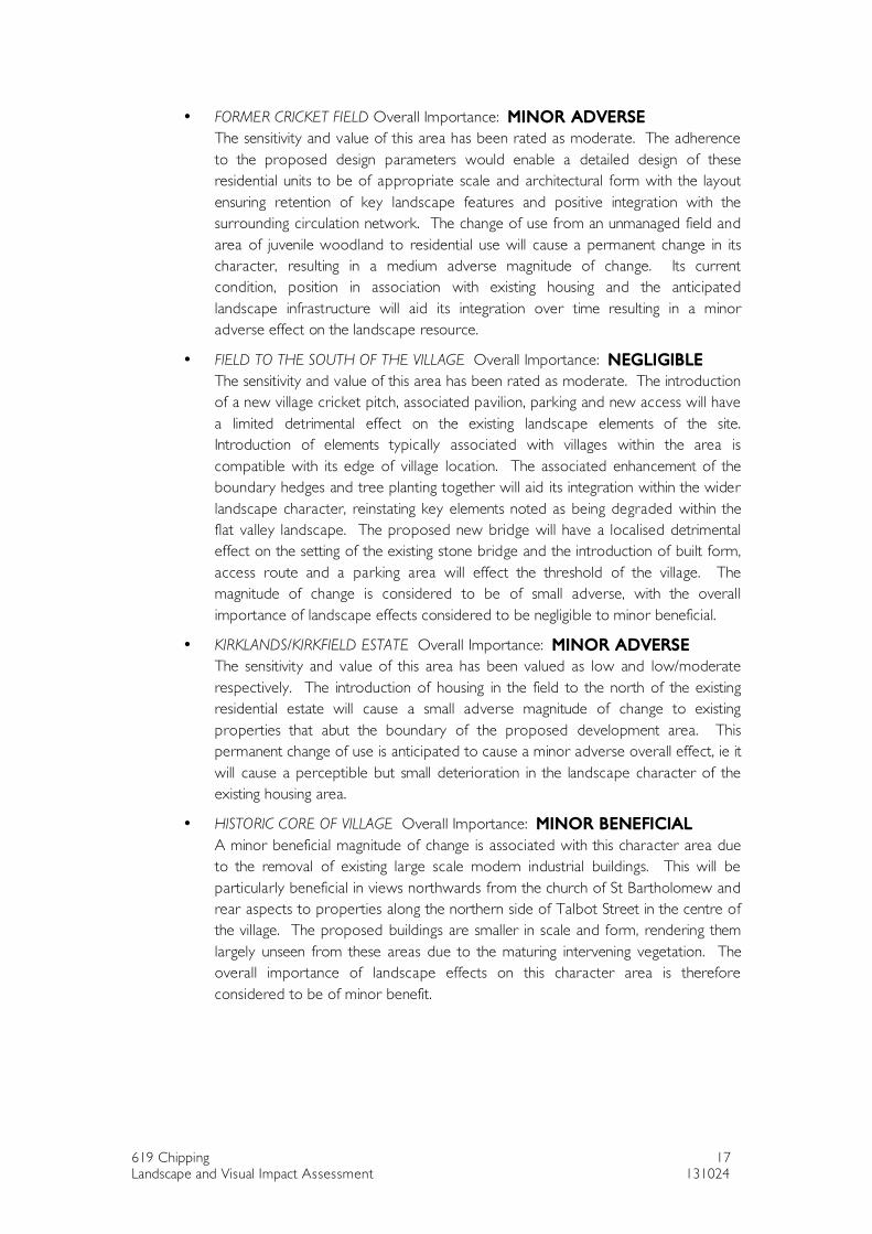
• FORMER CRICKET FIELD Overall Importance: MINOR ADVERSE The sensitivity and value of this area has been rated as moderate. The adherence
to the proposed design parameters would enable a detailed design of these residential units to be of appropriate scale and architectural form with the layout ensuring retention of key landscape features and positive integration with the surrounding circulation network. The change of use from an unmanaged field and area of juvenile woodland to residential use will cause a permanent change in its character, resulting in a medium adverse magnitude of change. Its current condition, position in association with existing housing and the anticipated landscape infrastructure will aid its integration over time resulting in a minor adverse effect on the landscape resource.
• FIELD TO THE SOUTH OF THE VILLAGE Overall Importance: NEGLIGIBLE The sensitivity and value of this area has been rated as moderate. The introduction
of a new village cricket pitch, associated pavilion, parking and new access will have a limited detrimental effect on the existing landscape elements of the site. Introduction of elements typically associated with villages within the area is compatible with its edge of village location. The associated enhancement of the boundary hedges and tree planting together will aid its integration within the wider landscape character, reinstating key elements noted as being degraded within the flat valley landscape. The proposed new bridge will have a localised detrimental effect on the setting of the existing stone bridge and the introduction of built form, access route and a parking area will effect the threshold of the village. The magnitude of change is considered to be of small adverse, with the overall importance of landscape effects considered to be negligible to minor beneficial.
• KIRKLANDS/KIRKFIELD ESTATE Overall Importance: MINOR ADVERSE The sensitivity and value of this area has been valued as low and low/moderate
respectively. The introduction of housing in the field to the north of the existing residential estate will cause a small adverse magnitude of change to existing properties that abut the boundary of the proposed development area. This permanent change of use is anticipated to cause a minor adverse overall effect, ie it will cause a perceptible but small deterioration in the landscape character of the existing housing area.
• HISTORIC CORE OF VILLAGE Overall Importance: MINOR BENEFICIAL A minor beneficial magnitude of change is associated with this character area due
to the removal of existing large scale modern industrial buildings. This will be particularly beneficial in views northwards from the church of St Bartholomew and rear aspects to properties along the northern side of Talbot Street in the centre of the village. The proposed buildings are smaller in scale and form, rendering them largely unseen from these areas due to the maturing intervening vegetation. The overall importance of landscape effects on this character area is therefore considered to be of minor benefit.
619 Chipping 18 Landscape and Visual Impact Assessment 131024
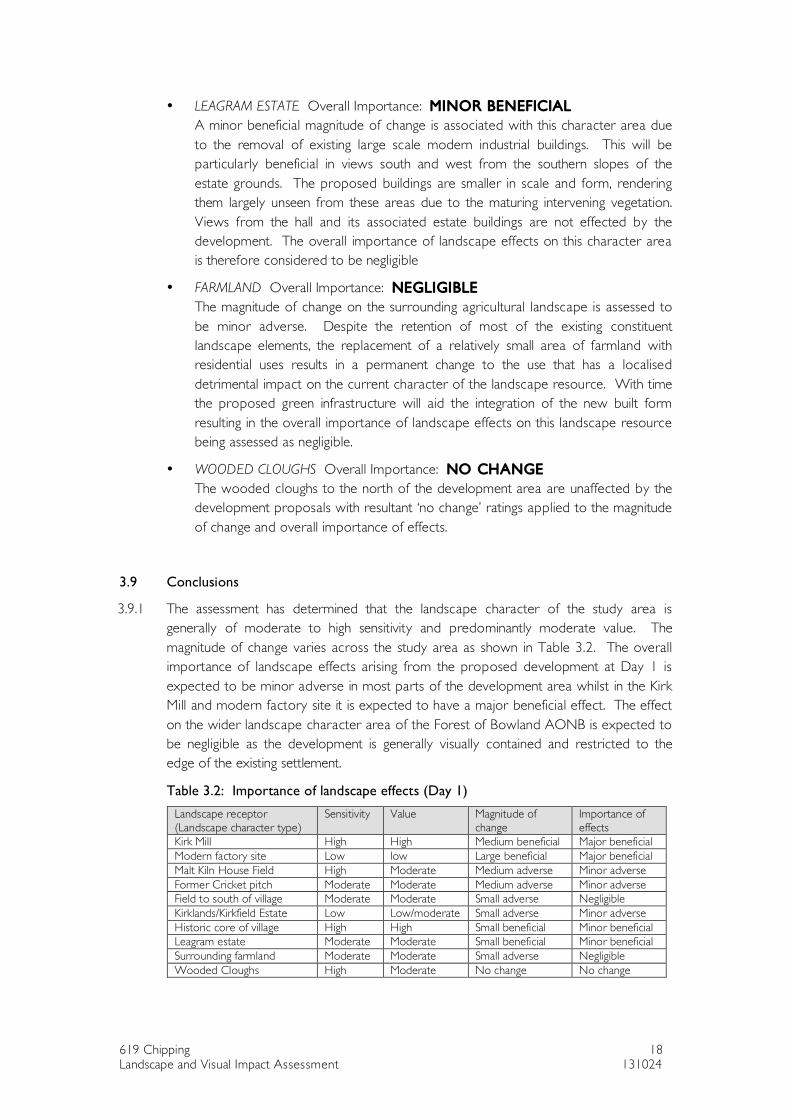
• LEAGRAM ESTATE Overall Importance: MINOR BENEFICIAL A minor beneficial magnitude of change is associated with this character area due
to the removal of existing large scale modern industrial buildings. This will be particularly beneficial in views south and west from the southern slopes of the estate grounds. The proposed buildings are smaller in scale and form, rendering them largely unseen from these areas due to the maturing intervening vegetation. Views from the hall and its associated estate buildings are not effected by the development. The overall importance of landscape effects on this character area is therefore considered to be negligible
• FARMLAND Overall Importance: NEGLIGIBLE The magnitude of change on the surrounding agricultural landscape is assessed to
be minor adverse. Despite the retention of most of the existing constituent landscape elements, the replacement of a relatively small area of farmland with residential uses results in a permanent change to the use that has a localised detrimental impact on the current character of the landscape resource. With time the proposed green infrastructure will aid the integration of the new built form resulting in the overall importance of landscape effects on this landscape resource being assessed as negligible.
• WOODED CLOUGHS Overall Importance: NO CHANGE The wooded cloughs to the north of the development area are unaffected by the
development proposals with resultant ‘no change’ ratings applied to the magnitude of change and overall importance of effects.
3.9 Conclusions
3.9.1 The assessment has determined that the landscape character of the study area is generally of moderate to high sensitivity and predominantly moderate value. The magnitude of change varies across the study area as shown in Table 3.2. The overall importance of landscape effects arising from the proposed development at Day 1 is expected to be minor adverse in most parts of the development area whilst in the Kirk Mill and modern factory site it is expected to have a major beneficial effect. The effect on the wider landscape character area of the Forest of Bowland AONB is expected to be negligible as the development is generally visually contained and restricted to the edge of the existing settlement.
Table 3.2: Importance of landscape effects (Day 1)
Landscape receptor (Landscape character type)
Sensitivity Value Magnitude of change
Importance of effects
Kirk Mill High High Medium beneficial Major beneficial Modern factory site Low low Large beneficial Major beneficial Malt Kiln House Field High Moderate Medium adverse Minor adverse Former Cricket pitch Moderate Moderate Medium adverse Minor adverse Field to south of village Moderate Moderate Small adverse Negligible Kirklands/Kirkfield Estate Low Low/moderate Small adverse Minor adverse Historic core of village High High Small beneficial Minor beneficial Leagram estate Moderate Moderate Small beneficial Minor beneficial Surrounding farmland Moderate Moderate Small adverse Negligible Wooded Cloughs High Moderate No change No change
619 Chipping 19 Landscape and Visual Impact Assessment 131024
4. VISUAL EFFECTS
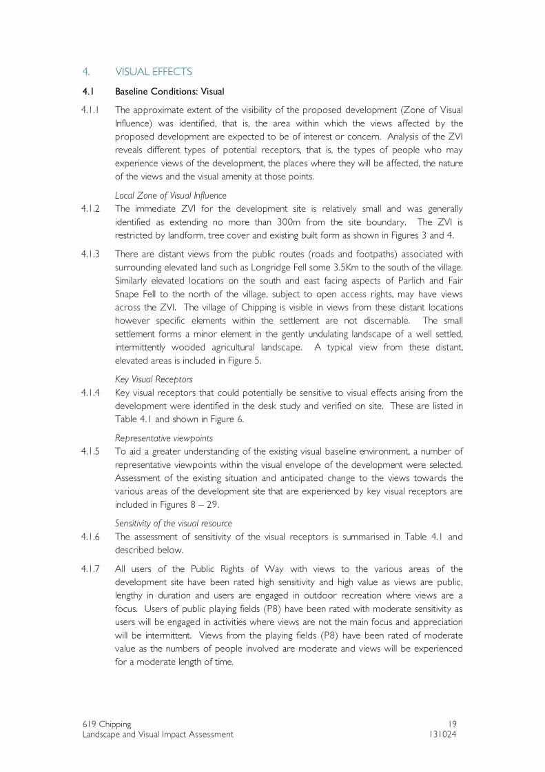
4.1 Baseline Conditions: Visual
4.1.1 The approximate extent of the visibility of the proposed development (Zone of Visual Influence) was identified, that is, the area within which the views affected by the proposed development are expected to be of interest or concern. Analysis of the ZVI reveals different types of potential receptors, that is, the types of people who may experience views of the development, the places where they will be affected, the nature of the views and the visual amenity at those points.
Local Zone of Visual Influence 4.1.2 The immediate ZVI for the development site is relatively small and was generally
identified as extending no more than 300m from the site boundary. The ZVI is restricted by landform, tree cover and existing built form as shown in Figures 3 and 4.
4.1.3 There are distant views from the public routes (roads and footpaths) associated with surrounding elevated land such as Longridge Fell some 3.5Km to the south of the village. Similarly elevated locations on the south and east facing aspects of Parlich and Fair Snape Fell to the north of the village, subject to open access rights, may have views across the ZVI. The village of Chipping is visible in views from these distant locations however specific elements within the settlement are not discernable. The small settlement forms a minor element in the gently undulating landscape of a well settled, intermittently wooded agricultural landscape. A typical view from these distant, elevated areas is included in Figure 5.
Key Visual Receptors 4.1.4 Key visual receptors that could potentially be sensitive to visual effects arising from the
development were identified in the desk study and verified on site. These are listed in Table 4.1 and shown in Figure 6.
Representative viewpoints 4.1.5 To aid a greater understanding of the existing visual baseline environment, a number of
representative viewpoints within the visual envelope of the development were selected. Assessment of the existing situation and anticipated change to the views towards the various areas of the development site that are experienced by key visual receptors are included in Figures 8 – 29.
Sensitivity of the visual resource 4.1.6 The assessment of sensitivity of the visual receptors is summarised in Table 4.1 and
described below.
4.1.7 All users of the Public Rights of Way with views to the various areas of the development site have been rated high sensitivity and high value as views are public, lengthy in duration and users are engaged in outdoor recreation where views are a focus. Users of public playing fields (P8) have been rated with moderate sensitivity as users will be engaged in activities where views are not the main focus and appreciation will be intermittent. Views from the playing fields (P8) have been rated of moderate value as the numbers of people involved are moderate and views will be experienced for a moderate length of time.
619 Chipping 20 Landscape and Visual Impact Assessment 131024
4.1.8 Road users have been rated with moderate sensitivity as drivers are engaged in activities not involving appreciation of views, however the routes are positioned in an attractive, well visited landscape and car users will be more aware of their environment than general highway corridors. Value has also been rated moderate as although views from cars are experienced for a short length of time or are fleeting, the high use of the local lanes by residents and visitors on foot renders them of higher sensitivity and importance than general highway corridors.
4.1.9 All residential receptors with views to the various areas of the development site have been rated with high sensitivity and low value as views are from private property and experienced by relatively small numbers of people.
4.1.10 Views from the grounds of the Church of St Bartholomew have been rated with high sensitivity as appreciation of setting and views contributes to the experience of this important listed building within the village. Value has been rated as high as the Church and its associated graveyard is recognised as a heritage asset.
Nature of the development 4.1.11 The general nature of the development is described in the Design and Access Statement
and summarized in Section 1.2 of this report. The potential visual changes introduced to the area may include:
• Removal of derelict elements. • Removal of elements that are out of context with the scale and setting of the
development area • Introduction of new built form to the village environment • Introduction/extension of nocturnal illumination in a generally unlit rural landscape
setting • Introduction of an improved green infrastructure that is in keeping with and
contributes to the general characteristics of the landscape character (Undulating lowland farming).
4.1.12 Elements that effect the visibility of the development areas within the ZVI
• Topography: much of the leisure related proposals, including the new car park and Trail Head facility are positioned in the base of the valley, which due to the change in level and the existing topographical features reduces the potential effect on views from the historic core and more recent extensions of the village.
• Existing vegetation • Size and scale of the development anticipated • Distance from the proposed area of development • People experiencing the view will be effected by the proposed changes to differing
degrees depending on their sensitivity to change in their visual environment
4.2 Assessment of visual effects
4.2.1 The evaluation of visual effects is considered for Day 1 and Year 15. This allows for the consideration of the effects of the maturity of landscape elements such as screen planting incorporated into the development.
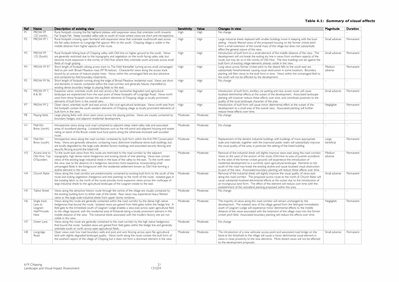
619 Chipping 21 Landscape and Visual Impact Assessment 131024
Table 4.1: Summary of visual effects Ref Name Desc rip tion of exis t ing v iew Sensit iv ity Value Changes in v iew Magni tude Dura tion P1 PROW FP
125 (north) Rural footpath crossing the flat highland plateau with expansive views that orientate north towards Fair Snape Fell. Steep wooded valley side to south of route where views are short and introspective.
High High No change - -
P2 PROW FP 1 Rural footpath crossing open farmland with expansive views that orientate south/south east across the flat valley bottom to Longridge Fell approx 4Km to the south. Chipping village is visible in the middle distance from higher aspects of the route.
High High Large industrial sheds replaced with smaller buildings more in keeping with the local setting. Heavily filtered views of the proposed housing on the former cricket pitch form a small extension of the overall mass of the village but does not substantially effect the general nature of the view.
Small adverse Permanent
P3 PROW FP 125 (South)
Rural footpath linking base of Chipping valley with Old hive on higher ground to the south. Views are generally restricted due to the topography and vegetation on the north facing valley side, but become more expansive in the vicinity of Old Hive where they orientate south and east across small fields of rough grazing.
High High Introduction of built form to a small element of the middle distance of the view. The development will not break the exiting sky line in views from northern aspects of the route, but may do so in the vicinity of Old Hive. The new buildings are set against the built form of existing village elements already visible in the view
Small adverse Permanent
P4 PROW FP 97 Short length of footpath utlising access track to The Field thereafter turning across small unmanaged field to join with Broad Meadow road (FP 96 below). Characterful views along the access track bound by an avenue of mature poplar trees. Views within the unmanaged field are less attractive and contained by field boundary treatments.
High High Long views across former cricket pitch to the distant fells to the south east are substantially foreshortened, causing visual obstruction in some locations. Boundary planting will filter views to the built form in time. Views within the unmanaged field to the south will not be effected by the development
Medium adverse
Permanent
P5 PROW FP 96 Short length of footpath running along the edge of Broad Meadow residential road. Views are short and domestic in nature, contained within the road corridor and generally heavily channelled by existing dense boundary hedge to playing fields to the east.
High High No change - -
P6 PROW FP 7, 8 & 30
Expansive views, orientate south and east across a flat, somewhat degraded rural agricultural landscape are experienced from the start point of these footpaths off Longridge Road. Views north west from these footpath contain the southern elements of Chipping village as locally prominent elements of built form in the overall view.
High High Introduction of built form, ancillary car parking and new access route will cause localised detrimental effects at the outset of the development. Associated landscape planting will however reduce these effects over time, and contribute positively to the quality of the local landscape character of the area
Small adverse Permanent
P7 PROW FP 2 Open views, orientate south and east across a flat rural agricultural landscape. Views north east from the footpath contain the south western elements of Chipping village as locally prominent elements of built form in the view.
High High Introduction of built form will cause minor detrimental effect at the outset of the development to a small area of the overall view. Associated planting will further reduce these effects over time.
Negligible Permanent
P8 Playing fields Large playing fields with short open views across the playing pitches. Views are visually contained by boundary hedges, and adjacent residential development.
Moderate Moderate No change - -
H1 Malt Kiln
Brow (north) Introspective views along rural road contained by adjacent steep sided valley side and associated areas of woodland planting. Localised features such as the mill pond and adjacent housing and estate railing on bend of the Brook create local focal points along the otherwise enclosed well wooded route.
Moderate Moderate No change - -
H2 Malt Kiln Brow (south)
Introspective views along the road corridor contained by built form within the Kirk Mill Conservation Area. Views are generally attractive, containing many distinctive traditional stone built buildings, but are locally degraded by the large scale derelict factory buildings and associated security fencing and security fencing around the listed mill.
Moderate Moderate Replacement of the derelict industrial buildings with buildings of more appropriate scale and materials, together with the improved public realm will substantially improve the visual quality of the area, in particular the setting of the listed building
Large beneficial
Permanent
H3 Access lane to Old Hive, Top O’Saunders
To the south east views from this route are restricted to the road corridor by the adjacent topography, high dense native hedgerows and existing stands of tree planting. Views east contain views of the existing large industrial sheds in the base of the valley to the east. To the north west the view, due to the absence of a hedgerow, becomes more expansive, incorporating small unmanaged fields in the foreground with the residential settlement known as Old Hive forming a skyline element in the view.
Moderate Moderate Removal of the industrial sheds will slightly improve views east along this road corridor. Views to the west of the section of the route (Old Hive to area of juvenile woodland to the west of the former cricket ground) will experience the introduction of residential development to a currently open agricultural landscape. Elements to the south of the road may break the existing skyline and cause localised visual obstruction to part of the view. Associated boundary planting will reduce these effects over time.
Medium adverse
Permanent
H4 Church Raike Views along the road corridor are predominantly contained by existing built form to the south of the route and exiting vegetation (hedgerow and tree planting) to the north of the route. Isolated gaps in the building fabric to the north of the route provide more expansive views across the roofscape of large industrial sheds to the agricultural landscape of the Leagram estate to the east.
Moderate Moderate Removal of the industrial sheds will slightly improve the visual quality of views east along this road corridor. The proposed access route to the north of Church Raike will cause substantial localised detrimental effects at the outset due to the introduction of an incongruous land form. The effect of this element will reduce over time with the establishment of the woodland planting proposed within this area.
Small adverse Permanent
H5 Talbot Street Views along the attractive historic route through the centre of the village are visually contained by the existing building form to either side of the street. Rear views may experience heavy filtered views or the large scale industrial sheds from upper storey windows
Moderate Moderate No change - -
H6 Single track Lane to Leagram Hall/Throstle Nest
Views along this route are generally contained within the road corridor by the dense high native hedgerows that bound the route. Isolated views are gained from field gates within the hedge line. A field gate to the immediate south of Leagram Lodge enables a view east across open agricultural field to the village beyond, with the residential area of Kirklands being a locally prominent element in the middle distance of the view. The industrial sheds associated with the modern factory site are not visible in this view.
Moderate Moderate The majority of views along this road corridor will remain unchanged by the development. The isolated view of the village gained from the field gate immediately south of Leagram Lodge will experience minor detrimental effects to the middle distance of the views associated with the extension of the village mass into the former cricket pitch field. Associated boundary planting will reduce the effects over time.
Negligible Permanent
H7 Green Lane Views along this route are generally contained to the road corridor by the high native hedgerows that bound the route. Isolated views are gained from field gates within the hedge line and generally orientate south or north across open agricultural fields.
Moderate Moderate No change - -
H8 Longridge Road
Open views over low road boundary walls and post and wire fencing across open flat agricultural land with slightly degraded landscape quality. Views north along the route contain the built form of the southern aspect of the village of Chipping but it does not form a dominant element in the view.
Moderate Moderate The introduction of a new vehicular access point and associated road bridge on the bend at the threshold to the village will cause a minor detrimental visual element in views in close proximity to the new elements. More distant views will not be effected by the development proposals.
Small adverse Permanent
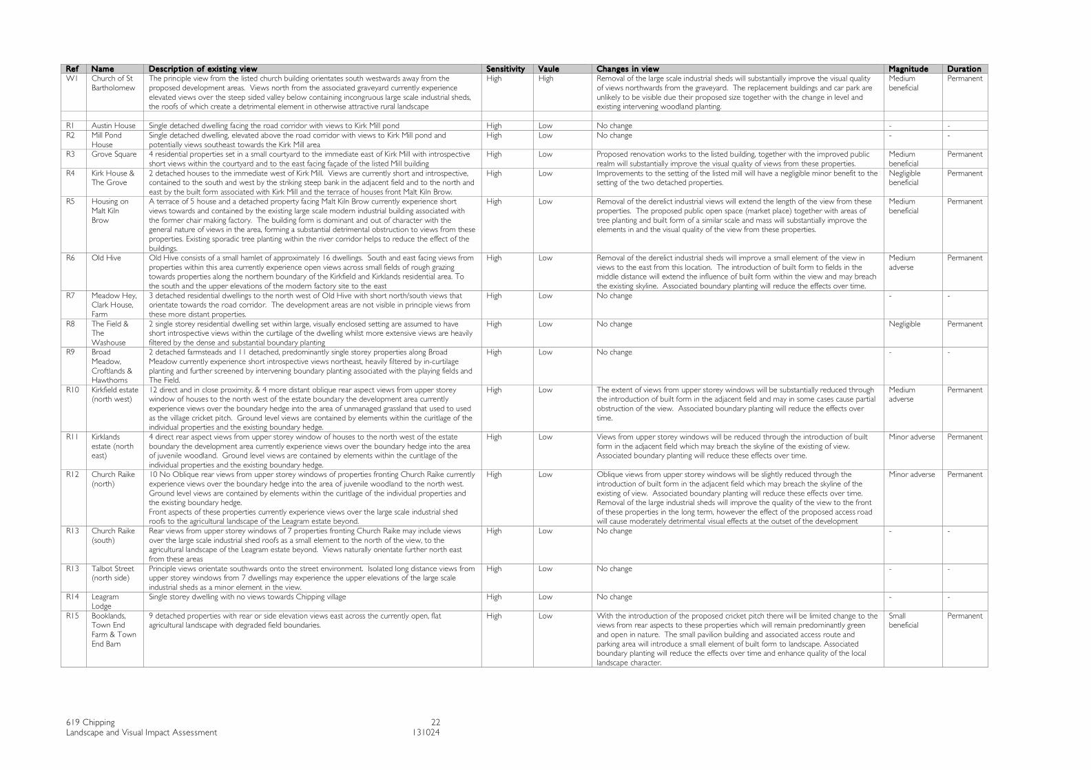
619 Chipping 22 Landscape and Visual Impact Assessment 131024
Ref Name Desc rip tion of exis t ing v iew Sensit iv ity Vaule Changes in v iew Magni tude Dura tion W1 Church of St
Bartholomew The principle view from the listed church building orientates south westwards away from the proposed development areas. Views north from the associated graveyard currently experience elevated views over the steep sided valley below containing incongruous large scale industrial sheds, the roofs of which create a detrimental element in otherwise attractive rural landscape
High High Removal of the large scale industrial sheds will substantially improve the visual quality of views northwards from the graveyard. The replacement buildings and car park are unlikely to be visible due their proposed size together with the change in level and existing intervening woodland planting.
Medium beneficial
Permanent
R1 Austin House Single detached dwelling facing the road corridor with views to Kirk Mill pond High Low No change - - R2 Mill Pond
House Single detached dwelling, elevated above the road corridor with views to Kirk Mill pond and potentially views southeast towards the Kirk Mill area
High Low No change - -
R3 Grove Square 4 residential properties set in a small courtyard to the immediate east of Kirk Mill with introspective short views within the courtyard and to the east facing façade of the listed Mill building
High Low Proposed renovation works to the listed building, together with the improved public realm will substantially improve the visual quality of views from these properties.
Medium beneficial
Permanent
R4 Kirk House & The Grove
2 detached houses to the immediate west of Kirk Mill. Views are currently short and introspective, contained to the south and west by the striking steep bank in the adjacent field and to the north and east by the built form associated with Kirk Mill and the terrace of houses front Malt Kiln Brow.
High Low Improvements to the setting of the listed mill will have a negligible minor benefit to the setting of the two detached properties.
Negligible beneficial
Permanent
R5 Housing on Malt Kiln Brow
A terrace of 5 house and a detached property facing Malt Kiln Brow currently experience short views towards and contained by the existing large scale modern industrial building associated with the former chair making factory. The building form is dominant and out of character with the general nature of views in the area, forming a substantial detrimental obstruction to views from these properties. Existing sporadic tree planting within the river corridor helps to reduce the effect of the buildings.
High Low Removal of the derelict industrial views will extend the length of the view from these properties. The proposed public open space (market place) together with areas of tree planting and built form of a similar scale and mass will substantially improve the elements in and the visual quality of the view from these properties.
Medium beneficial
Permanent
R6 Old Hive Old Hive consists of a small hamlet of approximately 16 dwellings. South and east facing views from properties within this area currently experience open views across small fields of rough grazing towards properties along the northern boundary of the Kirkfield and Kirklands residential area. To the south and the upper elevations of the modern factory site to the east
High Low Removal of the derelict industrial sheds will improve a small element of the view in views to the east from this location. The introduction of built form to fields in the middle distance will extend the influence of built form within the view and may breach the existing skyline. Associated boundary planting will reduce the effects over time.
Medium adverse
Permanent
R7 Meadow Hey, Clark House, Farm
3 detached residential dwellings to the north west of Old Hive with short north/south views that orientate towards the road corridor. The development areas are not visible in principle views from these more distant properties.
High Low No change - -
R8 The Field & The Washouse
2 single storey residential dwelling set within large, visually enclosed setting are assumed to have short introspective views within the curtilage of the dwelling whilst more extensive views are heavily filtered by the dense and substantial boundary planting
High Low No change Negligible Permanent
R9 Broad Meadow, Croftlands & Hawthorns
2 detached farmsteads and 11 detached, predominantly single storey properties along Broad Meadow currently experience short introspective views northeast, heavily filtered by in-curtilage planting and further screened by intervening boundary planting associated with the playing fields and The Field.
High Low No change - -
R10 Kirkfield estate (north west)
12 direct and in close proximity, & 4 more distant oblique rear aspect views from upper storey window of houses to the north west of the estate boundary the development area currently experience views over the boundary hedge into the area of unmanaged grassland that used to used as the village cricket pitch. Ground level views are contained by elements within the curitlage of the individual properties and the existing boundary hedge.
High Low The extent of views from upper storey windows will be substantially reduced through the introduction of built form in the adjacent field and may in some cases cause partial obstruction of the view. Associated boundary planting will reduce the effects over time.
Medium adverse
Permanent
R11 Kirklands estate (north east)
4 direct rear aspect views from upper storey window of houses to the north west of the estate boundary the development area currently experience views over the boundary hedge into the area of juvenile woodland. Ground level views are contained by elements within the curitlage of the individual properties and the existing boundary hedge.
High Low Views from upper storey windows will be reduced through the introduction of built form in the adjacent field which may breach the skyline of the existing of view. Associated boundary planting will reduce these effects over time.
Minor adverse Permanent
R12 Church Raike (north)
10 No Oblique rear views from upper storey windows of properties fronting Church Raike currently experience views over the boundary hedge into the area of juvenile woodland to the north west. Ground level views are contained by elements within the curitlage of the individual properties and the existing boundary hedge. Front aspects of these properties currently experience views over the large scale industrial shed roofs to the agricultural landscape of the Leagram estate beyond.
High Low Oblique views from upper storey windows will be slightly reduced through the introduction of built form in the adjacent field which may breach the skyline of the existing of view. Associated boundary planting will reduce these effects over time. Removal of the large industrial sheds will improve the quality of the view to the front of these properties in the long term, however the effect of the proposed access road will cause moderately detrimental visual effects at the outset of the development
Minor adverse Permanent
R13 Church Raike (south)
Rear views from upper storey windows of 7 properties fronting Church Raike may include views over the large scale industrial shed roofs as a small element to the north of the view, to the agricultural landscape of the Leagram estate beyond. Views naturally orientate further north east from these areas
High Low No change - -
R13 Talbot Street (north side)
Principle views orientate southwards onto the street environment. Isolated long distance views from upper storey windows from 7 dwellings may experience the upper elevations of the large scale industrial sheds as a minor element in the view.
High Low No change - -
R14 Leagram Lodge
Single storey dwelling with no views towards Chipping village High Low No change - -
R15 Booklands, Town End Farm & Town End Barn
9 detached properties with rear or side elevation views east across the currently open, flat agricultural landscape with degraded field boundaries.
High Low With the introduction of the proposed cricket pitch there will be limited change to the views from rear aspects to these properties which will remain predominantly green and open in nature. The small pavilion building and associated access route and parking area will introduce a small element of built form to landscape. Associated boundary planting will reduce the effects over time and enhance quality of the local landscape character.
Small beneficial
Permanent
619 Chipping 23 Landscape and Visual Impact Assessment 131024
4.3 Magnitude of visual effects
4.3.1 The assessment of magnitude of visual effects on each representative viewpoint is summarised in Table 4.1. The definition of the magnitude of visual effects are contained within Appendix 1; Table 1.2.
4.4 Importance of effects on visual amenity
4.4.1 The importance of visual effects is summarised in Table 4.1 based on the preceding assessment of sensitivity, importance and magnitude of change. The overall importance of visual effects varies according to each localised character area, the sensitivity of the visual receptors and the type of development proposed. Each character area is identified in the baseline studies is considered below.
• KIRK MILL: Overall importance: MAJOR BENEFICIAL The sympathetic renovation works proposed to the building, together with the removal of existing site security fencing and the provision of a new, high quality public realm to the front aspect of the listed building is considered to be of major beneficial importance to road users (vehicular and pedestrian) and adjacent residential properties within the conservation area.
• MODERN FACTORY SITE: Overall importance: MAJOR BENEFICIAL Removal of the large scale modern industrial buildings that are out of context with the intimate scale and character of the valley landscape and the domestic scale urban grain of the village is assessed to be of major beneficial importance. The replacement of these buildings by buildings demonstrating a more sympathetic relationship with buildings within their immediate setting, i.e. In keeping with the scale, orientation and materials of the Kirk Mill Conservation Area has been assessed as being of major beneficial importane to users of the adjacent highway (Malt Kiln Brow and Church Raike) and residential properties that address these road corridors.
The area of development to the south of this area includes the provision of a new, embanked access road. Initial visual effects associated with this route will be moderately detrimental to users of Church Raike and residential properties that address this road corridor. The route will also be visible in views from the Kirk Mill Conservation Area, however no historic elements will be viewed against the new landform. In time, with the maturing of the woodland planting proposed within this area, the new landform will merge with the semi mature tree planting on the existing steep banks, reducing the long term visual importance to minor detrimental/negligible.
• MALT KILN HOUSE FIELD: Overall importance: MINOR ADVERSE Assuming the detailed proposals adhere to the design parameters set within the Design and Access Statement and mitigation measures identified within this report, the proposed limited number of residential units in the field to the west of Malt Kiln House is considered to be of minor adverse visual importance to road users of the adjacent road and footpath users and to residents with east/south east facing views from Old Hive. The nature of these views will change from the current, poorly managed open agricultural field to a new distinctive residential landscape of
619 Chipping 24 Landscape and Visual Impact Assessment 131024
bespoke buildings, designed to sit sympathetically within the landscape, set within large garden areas with traditional, locally common boundaries such as native hedgerows, walls and estate railings. The change will effect the majority of the view in views from the immediate surrounding, with a smaller area effected with greater distance from the source of the change.
More distant, heavily filtered views from the opposite valley side, in particular upper aspects of Footpath No 1, will experience a negligible change to a small element of the view, resulting in an overall of negligible rating of importance. Proposed tree planting associated with the development area, in particular the reinforcement of boundary treatments and the wooded clough to the east of the development plot will reduce the effect on views from these more elevated locations further with time.
• FORMER CRICKET PITCH: Overall importance: MODERATELY ADVERSE Assuming the detailed proposals adhere to the design parameters set within the Design and Access Statement and mitigation measures identified within this report, the proposed residential area, comprising approximately 55 two storey dwellings, together with ancillary buildings, associated infrastructure and the proposed landscape framework will result in moderately adverse visual effects to adjacent road and footpath users and existing residential properties along the northern edge of the Kirkfield and Kirklands residential area.
The nature of these views will change from the current field boundary treatments with unmanaged grassland beyond to a new residential area. Viewers may experience partial visual obstruction through the introduction of built form in close proximity to the source of the view. South facing views from Old Hive and footpath No 125 (South) will experience change to the middle distance of the view, where the proposed development breach the existing skyline. More distant, filtered views from the opposite valley side, from Footpath No 1 and isolated points on the local access route from Leagram Hall will experience a minor adverse change to a small element of the overall view resulting in a overall negligible rating of importance. The landscape proposals will soften the effect on these views over time as the vegetation matures providing an increasingly effective filter to the built form.
• FIELD TO THE SOUTH OF THE VILLAGE: Overall importance: NEGLIGIBLE The proposed cricket pitch will introduce elements typically associated with villages in this area, to the southern threshold of the village. Users of Longridge Road, Footpaths Nos 7, 8 and 30 and rear aspects of properties bounding Chipping Brook will experience a change in the existing agricultural field with degraded field boundaries to a managed cricket ground. A small pavilion building, new vehicular bridge, access route and car parking area is positioned to the south of the site, set within a woodland block mimicking a landscape element typical of the area and reducing the visual intrusion of these elements on its rural hinterland. The overall visual importance of these changes is assessed to be of negligible/minor adverse at the outset of the development, but as the associated vegetation becomes established this will reduce to minor beneficial/negligible importance in the long term visual importance.

619 Chipping 25 Landscape and Visual Impact Assessment 131024
4.5 Mitigation measures
4.5.1 The visual impact assessment was undertaken assuming the primary mitigation measures identified within section 1.2.4 – 1.2.6 were undertaken. These mitigation measures are associated with detailed planning application areas. The following mitigation measures for the two outline applications should be included within the design parameters for the development of the detailed proposals to ensure due consideration is given to the anticipated visual effects associated with these developments.
Field to the rear of Malt Kiln Brow House • Consider the orientation and scale of individual elements in relation to the setting of
Kirk Mill and its associated Conservation Area. Exploration of bespoke responses utilising the distinct landform to absorb the building mass should be explored.
• Consider the overall massing and interrelationship of the dwellings within this development area. Consider the resolution of this design response in relationship with the residential development area to the south of the road. Although not connected physically, visual links, through the careful placement of buildings and green infrastructure will aid the integration of the overall settlement extension.
• The height of buildings should be comparable to residential dwellings in the vicinity, such as Old Hive, where buildings comprise two levels and a pitched roof above existing ground levels.
• Minimise associated ancillary clutter such as sub stations and bin stores by considering sub-terranean elements or assimilation within the built form of the individual dwellings.
• Minimise the width of the proposed vehicular access and use materials compatible with its rural setting to create a narrow, shared access route.
• Illumination of the highway should be minimal to minimise nocturnal light pollution and erosion of the rural character. Consideration of sensory activated lights should be considered to ensure routes are only illuminated when they are used.
• Retain and incorporate existing mature trees within the landscape proposals. • Enhance the wooded clough through additional tree planting on the existing steep
banks to reinstate a key landscape characteristic of the local landscape character area and to filter views towards the area of development.
• Garden boundaries should reflect the local field boundaries within the area. Back gardens would be most appropriately defined by traditional hedgerows and intermittent standard tree planting. Front gardens may reflect dry stone walls or utilise metal estate railings that feature within the local landscape.
Former Cricket field • Ensure proposed housing is positively integrated with the adjacent residential areas
through the overall layout and consideration of pedestrian movement • Consider the overall massing and interrelationship of the dwellings with existing built
form in the vicinity. • The height of buildings should be comparable to dwellings in the vicinity, • Consider the use of shared surfaces to reduce the dominance of vehicles and
maximise the potential for potential green space within the residential area. • Consider the provision of productive landscape elements such as fruiting trees and
hedges, wild foraging areas and community garden space.
619 Chipping 26 Landscape and Visual Impact Assessment 131024
4.6 Conclusions
4.6.1 The assessment has established that the Kirk Mill and the associated modern factory site are well contained by the strongly defined local landform supported by existing vegetation cover. These factors limit the views of the site from its immediate locality and the wider area.
4.6.2 During the construction phase, there will be a period of short term, locally adverse effects but these will be confined to short distance views and will be largely screened by construction hoardings and further filtered by intervening vegetation.
4.6.3 The core of the proposed built development in this area will comprise sensitively designed structures in materials with muted colours that will harmonise with and integrate into the landscape in the longer term. Furthermore, the development provides the opportunity to introduce substantial areas of new woodland and tree planting. This new woodland infrastructure will soften and screen the visual effects of the new buildings and contribute to and enhance both the character of the site and the quality of the landscape setting of the Kirk Mill Conservation Area.
4.6.4 Areas of residential development on higher ground to the north of the village are more visually exposed at the outset of the development. Site hoardings will help to screen views of construction activity from views in the immediate vicinity. The proposed built form is to be controlled by a set of design parameters ensuring the areas are sensitively integrated both physically and visually within its village edge setting. The development provides the opportunity to introduce further tree and shrub planting within the development area. This vegetation will soften and screen visual effects of the new buildings and contribute to the local landscape character of the area.
4.6.5 The proposed cricket pitch will introduce a traditional village feature to the southern threshold of the village. The existing low lying flat agricultural field is currently visually exposed due to the degraded field boundaries. During the construction phase, there will be a period of short term, locally adverse effects but these will be confined to short distance views and will be largely screened by construction hoardings. The limited built form proposed within this area will become increasingly screened by its associated tree planting, aiding its integration within the wider rural landscape.
4.6.6 At Year 15, once the new planting has established, overall importance of visual effects are considered to be generally of Minor Beneficial rising to major beneficial importance with the development associated with Kirk Mill and the Modern factory site redevelopment. The effect on the wider landscape character area of the Forest of Bowland AONB is expected to be negligible as the development is generally visually contained and restricted to the edge of the existing settlement.
619 Chipping 27 Landscape and Visual Impact Assessment 131024
References Swanwick, Prof C. (2013) Guidelines for Landscape and Visual Assessment. Routledge, Oxon. ISBN: 978-0-415-68004-2. NCA 33: Bowland Fringes and Pendle Hill (Nov 2012) Lancashire county Council. A Landcsape Strategy for Lancashire – Landscape Character Assessment; 2009 PROW – Lancashire web based information Listed buildings – CPRE web site. Chipping Historical Society web site:
List of Figures Figure 1: Site location and landscape context Figure 2: Landscape character areas within the Proposed Development area Figure 3: Visual context (Development areas 1, 2, 3 and 4) Figure 4: Visual context (Development area 5) Figure 5: View from Longridge Fell Figure 6: Visual Receptors Figure 7: Representative view points location plan Figure 8: Representative view 1 View south east along Malt Kiln Brow from
Austin House Figure 9: Representative view 2 View south from lower valley side on FP1 Figure 10: Representative view 3 View south from upper valley side on FP1 Figure 11: Representative view 4 View south from Grove Sqaure towards along
Malt Kiln Brow Figure 12: Representative view 5 View north along Malt Kiln Brow towards Kirk
Mill Figure 13: Representative view 6 View west along lane to/from Old Hive Figure 14: Representative view 7 View north east along lane to/from Old Hive Figure 15: Representative view 8 View south east from FP125 at field corner Figure 16: Representative view 9 View east along lane to/from Old Hive Figure 17: Representative view 10 View north east from FP97 Figure 18: Representative view 11 View north from FP96/Broad meadow Figure 19: Representative view 12 View east along path to rear of properties on
northern edge of the Kirkfield estate Figure 20: Representative view 13 View west along path to rear of properties on
northern edge of the Kirkfield estate Figure 21: Representative view 14 View north from Church Raike Figure 22: Representative view 15 View north west along Church Raike from
Kirklands junction Figure 23: Representative view 16 View northwest from St Bartholomew’s
church yard Figure 24: Representative view 17 View south west along Talbot Street Figure 25: Representative view 18 View south west from field gate below
Leagram Lodge Figure 26: Representative view 19 View west along Green Lane approaching
village Figure 27: Representative view 20 View south through field gate on Green Lane Figure 28: Representative view 21 View north east from footbridge FP7, 8 & 30 Figure 29: Representative view 22 View north east along Longridge Road
List of Appendices Appendix 1: Methodology
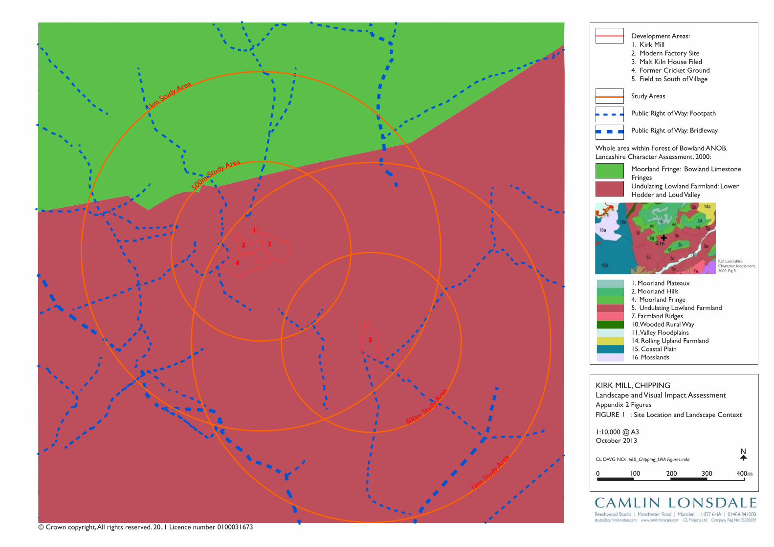
Track
Wharf Farm
Chipping
Brook Bridge
Grove Square
Meadow
Hey
Hawthorns
Track
Issues
Black Hall
Croft
Path
Iss
Isaacs
House
Tk
Path
Drain
Dr ain
Parlick
Track
Trac
k
Farm
Works
Sinks
Birchen Lee
Blackhall
Brook
CG
CG
CG
Chipping
Dairy Barn
Dairy Farm
Drain
Dr ain
Drain
Dra in
Drain
Drain
Dra in
Dra in
FB
FB
FB
FB
FB
FB
FB
FB
FB
Fairhaven
Farm
Ferry Butts
Green
Grove
Harling House
Highfield
Hill Clough
Holton Hill
House
Isaac's Farm
Issues
Issues
Issues
Issues
Issues
Issues
Issues
Issues
Issues
Issues
Issues
Issues
Issues
Issues
Issues
Issues
Issues
Issues
Issues
Issues
Issues
Issues
Issues
Issues
Issues
Issues
IssuesIssues
Issues
Issues
Issues
Issues
Issues
Issues
Issues
Issues
Issues
Issues
Issues
Issues
CT
DLEI
FKO
ORB
DL
EIF
KRI
K
SD
NALK
RIK
CT
SYDEEWT
DLEI
FK
RIK
SD
NALK
OO
RB
KIRK
LAND
S
TE
ERT
SY
DNI
W
ENAL
SWINGLEHURST
DLEIFKRIK
WO
RB
NLI
KTL
AM
TEE
RTS
T
OBLAT
WODAEM
BROAD
RAIKE
CHURCH
LANE
GREEN
EN
ALESUOHHSIF
LANE
HOUSE
KCAL
B
LANE
MOSS
DAOR
GNATS
RAG
LANE
EGANOSRAP
Issues
Issues
Issues
Issues
Issues
Issues
Issues
Issues
Issues
Issues
Issues
Issues
Issues
Issues
Issues
Issues
Issues
Issues
Issues
Issues
Issues
Issues
Issues
Issues
Issues
Issues
Kirk Mills
Lane Ends
Leag
ram
Bro
ok
Lingey Hill
Long
Mill
Moss Side
Nan
Pale Farm
Wolfen
Weirs
Weir
Weir
Weir
Weir
Weir
Weir
Top O'Saunders
Three
Startifants
Spr
Spr
Spr
Spr
Spr
Spr
Spr
Spr
Sluice
SlackSinks
Sinks
Sinks
Sinks
Sinks
Sinks
Sinks
Sinks
Sinks
Sinks
Sinks
Sinks
Sinks
Sinks
Showground
Plantation
Path
Path
Path Path
Path
Path
Path
Path
Pat h
Path
Path
Path
Path
Path
Path
Path
Path
Track
Track
Track
Tra c
k
Track
163m
163m
176m
204m
162m
156m
169m
98m
97m
Aust in
101m
96m
96m
102m
196m
183m
193m
182m
147m
113m
97m
147m
134m
109m
94m
93m
93m
89m
169m
131m
139m
117m
107m
190m
185m
175m
1 70 m
170m
165m
160m
180m
195m
190m
190m
200m
190m
180m
170m
19 5m
155m
150m
145m 1 40 m
135m
130m
175m
165m
160m
145m
120m
110m
100m
95m
140m
135m
125m
200m
195m
190m
180m
170m
160m
150m
140m
135m
130m
125m
100m
100m
105m
110m
115m
120 m
100m
Wolfen Hall
Holme
Plantation
Paths
Wolfen
Hall
Pa th
Fish
House
IssPath
Sl
Do b
son'
sB
rook
Path
Path
Path
Path
The Grove
King's Wood
Iss
Bradley
Nan King's
Farm
Peacock Hey
Farm
Path
Pat h
Windy Hills
Farm
Path
Springs
House
Path
GP
After
Lee
P ath
Sta
Pol
Cricket
Ground
Pav
Old
Hive
Sch
Sch
PW
PO
PW
Vic
The
Field
Iss
Path
Path
Path
P at h
Abbot
Barn
Clark
House
Path
C h i p p i n gPW
Works
Path
War
Meml
Iss
Iss
Leagram
Lodge
Pat h
Chi
ppin
gB
rook
Path
Path
Iss
Brickhouse
Cottage
Issues
Leagram
Hall
IssCottage
Wood
Throstle Nest
GP
Cuthbert
Hill
Path
Radcliffe
Hall
Daub
Hall
Little Daub
Hall
The
Croft
Meridor
GP
Sewage
Works
Hardiker
House
Brookside
High
Head
Goose Lane
Cottages
New
Barnf ield
Radcliffe Cottage
High Head
Wood
Valve House
Hotel
Old VicarageAstley
House
Moss Lane
House
125m
Path
Buckbanks
Laund
Farm
Iss
Iss
GP
Iss
HallPlaying
Fields
Stables
Cottage
Drain
Iss
KirK Mill, Chippinglandscape and Visual impact Assessment
FigUrE : Site location and landscape ContextAppendix 2 Figures
1:10,000 @ A3October 2013
Development Areas:1. Kirk Mill2. Modern Factory Site3. Malt Kiln house Filed4. Former Cricket ground5. Field to South of Village
Study Areas
public right of Way: Footpath
public right of Way: Bridleway
Cl DWg nO: 660_Chipping_LVIA Figures.inddN
0 100 200 300 400m
© Crown copyright, All rights reserved. 20..1 licence number 0100031673
500m
Study Area
500m Stud
y Are
a
1km St
udy Area
1km St
udy A
rea
4
3
5
2
1
1
Whole area within Forest of Bowland AnOB.lancashire Character Assessment, 2000:
ref. lancashire Character Assessment, 2000: Fig 8
Site
1. Moorland plateaux2. Moorland hills4. Moorland Fringe5. Undulating lowland Farmland7. Farmland ridges10.Wooded rural Way11. Valley Floodplains14. rolling Upland Farmland15. Coastal plain16. Mosslands
Moorland Fringe: Bowland limestone Fringes Undulating lowland Farmland: lower hodder and loud Valley
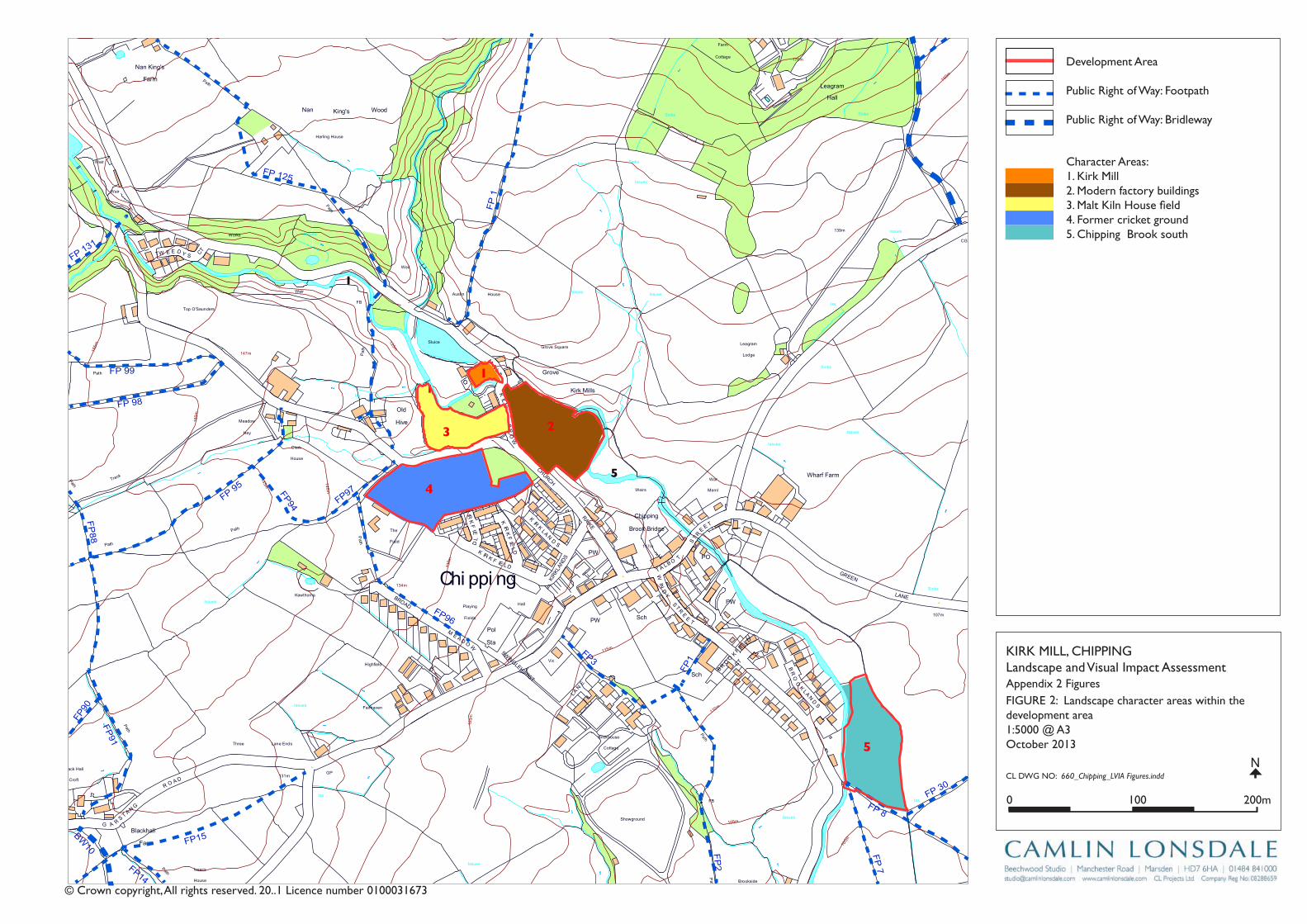
Track
Wharf Farm
Chipping
Brook Bridge
Grove Square
Meadow
Hey
Hawthorns
Track
Issues
Black Hall
Croft
Path
Iss
Isaacs
House
Tk
Pat
h
Drain
Drain
Track
Farm
Works
Sinks
Blackhall
CG
Dairy Barn
Dairy Farm
Drain
Dr ain
Drain
Drain
Drain
Drain
Drain
FB
FB
FB
FB
FB
Fairhaven
Farm
Ferry Butts
Green
Grove
Harling House
Highfield
Hill Clough
Holton Hill
House
Isaac's Farm
Issues
Issues
Issues
Issues
Issues
Issues
Issues
Issues
Issues
Issues
Issues
Issues
Issues
Issues
Issues
Issues
Issues
Issues
Issues
Issues
Issues
Issues
CT
DLEI
FK
OO
RB
DL
EIF
KRI
K
SD
NALK
RIK
CT
SYDEEWT
DLEI
FK
RIK
SD
NALK
OO
RB
KIRK
LAND
S
TE
ERTS
YD
NIW
EN
AL
SWINGLEHURST
DLEIFKRIK
WO
RB
NLI
KTL
AM
TEE
RTS
T
OBLAT
WODAEM
BROAD
RAIKE
CHURCH
LANE
GREEN
EN
ALESUOHHSIF
LANE
HOUSE
KCAL
B
LANE
MOSS
DAOR
GNATSRAG
Issues
Issues
Issues
Issues
Issues
Issues
Issues
Issues
Issues
Issues
Issues
Issues
Issues
Kirk Mills
Lane Ends
Leag
ram
Bro
ok
Lingey Hill
Mill
Moss Side
Nan
Wolfen
Weirs
Weir
Weir
Weir
Weir
Weir
Top O'Saunders
Three
Startifants
Spr
Spr
Spr
Spr
Spr
Spr
Sluice
SlackSinks
Sinks
Sinks
Sinks
Sinks
Sinks
Sinks
Sinks
Sinks
Showground
Pat
h Path
Path
Path
Path
Path
Path
Path
Path
Path
Pat
h
Track
Track
Track
163m
163m
176m
162m
156m
169m
98m
97m
Austin
101m
96m
96m
102m
113m
97m
147m
134m
109m
169m
131m
139m
117m
107m
190m
185m
175m
170m
170m
165m
160m
195 m
155m
150m
145m 14 0m
1 35 m
130m
175m
165m
160m
145m
120m
110m
100m
140m
135m
125m
170m
160m
150m
140m
135m
130m
125m
100m
100m
105m
110m
115m
120m
100m
Holme
Paths
Fish
House
IssPath
Dob
son'
sBr
ook
Path
Path
Path
The Grove
King's Wood
Iss
Nan King's
Farm
Path
Path
Springs
House
Path
GP
After
Lee
Pat h
Sta
Pol
Cricket
Ground
Pav
Old
Hive
Sch
Sch
PW
PO
PW
Vic
The
Field
Iss
Path
Path
Path
Pat h
Abbot
Barn
Clark
House
Path
C h i p p i n gPW
Works
Pat
h
War
Meml
Iss
Iss
Leagram
Lodge
Path
Chi
ppin
gBr
ook
Path
Path
Iss
Brickhouse
Cottage
Issues
Leagram
Hall
IssCottage
Throstle Nest
GP
Cuthbert
Hill
Path
Radcliffe
Hall
Daub
Hall
Little Daub
Hall
The
Croft
Meridor
GP
Sewage
Works
Brookside
High
Head
Goose Lane
Cottages
New
Barnfield
Radcliffe Cottage
High Head
Wood
Valve House
Hotel
Moss Lane
House
125m
Path
Iss
Iss
HallPlaying
Fields
KirK Mill, Chippinglandscape and Visual impact AssessmentAppendix 2 Figures
Cl DWg nO: 660_Chipping_LVIA Figures.inddN
© Crown copyright, All rights reserved. 20..1 licence number 0100031673
1
2
0 100 200m
1:5000 @ A3October 2013
FP 1
FP 125
FP 98
FP88
FP90
FP91
FP15
FP3
FP2
FP1
FP96
FP97FP94
FP14
BW10
FP 95
FP 99
FP 131
FP 30
FP 8
FP 7
2
1
3
4
5
Development Area
public right of Way: Footpath
public right of Way: Bridleway
FigUrE : landscape character areas within the development area
Character Areas:1. Kirk Mill2. Modern factory buildings3. Malt Kiln House field4. Former cricket ground5. Chipping Brook south
1
5
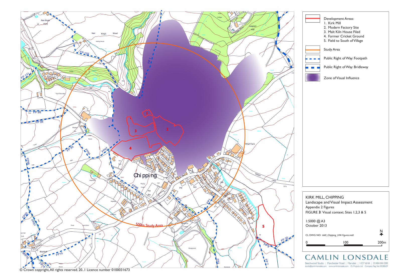
Track
Wharf Farm
Chipping
Brook Bridge
Grove Square
Meadow
Hey
Hawthorns
Track
Issues
Black Hall
Croft
Path
Iss
Isaacs
House
Tk
Pat
h
Drain
Drain
Track
Farm
Works
Sinks
Blackhall
CG
Dairy Barn
Dairy Farm
Drain
Dr ain
Drain
Drain
Drain
Drain
Drain
FB
FB
FB
FB
FB
Fairhaven
Farm
Ferry Butts
Green
Grove
Harling House
Highfield
Hill Clough
Holton Hill
House
Isaac's Farm
Issues
Issues
Issues
Issues
Issues
Issues
Issues
Issues
Issues
Issues
Issues
Issues
Issues
Issues
Issues
Issues
Issues
Issues
Issues
Issues
Issues
Issues
CT
DLEI
FK
OO
RB
DL
EIF
KRI
K
SD
NALK
RIK
CT
SYDEEWT
DLEI
FK
RIK
SD
NALK
OO
RB
KIRK
LAND
S
TE
ERTS
YD
NIW
EN
AL
SWINGLEHURST
DLEIFKRIK
WO
RB
NLI
KTL
AM
TEE
RTS
T
OBLAT
WODAEM
BROAD
RAIKE
CHURCH
LANE
GREEN
EN
ALESUOHHSIF
LANE
HOUSE
KCAL
B
LANE
MOSS
DAOR
GNATSRAG
Issues
Issues
Issues
Issues
Issues
Issues
Issues
Issues
Issues
Issues
Issues
Issues
Issues
Kirk Mills
Lane Ends
Leag
ram
Bro
ok
Lingey Hill
Mill
Moss Side
Nan
Wolfen
Weirs
Weir
Weir
Weir
Weir
Weir
Top O'Saunders
Three
Startifants
Spr
Spr
Spr
Spr
Spr
Spr
Sluice
SlackSinks
Sinks
Sinks
Sinks
Sinks
Sinks
Sinks
Sinks
Sinks
Showground
Pat
h Path
Path
Path
Path
Path
Path
Path
Path
Path
Pat
h
Track
Track
Track
163m
163m
176m
162m
156m
169m
98m
97m
Austin
101m
96m
96m
102m
113m
97m
147m
134m
109m
169m
131m
139m
117m
107m
190m
185m
175m
170m
170m
165m
160m
195 m
155m
150m
145m 14 0m
1 35 m
130m
175m
165m
160m
145m
120m
110m
100m
140m
135m
125m
170m
160m
150m
140m
135m
130m
125m
100m
100m
105m
110m
115m
120m
100m
Holme
Paths
Fish
House
IssPath
Dob
son'
sBr
ook
Path
Path
Path
The Grove
King's Wood
Iss
Nan King's
Farm
Path
Path
Springs
House
Path
GP
After
Lee
Pat h
Sta
Pol
Cricket
Ground
Pav
Old
Hive
Sch
Sch
PW
PO
PW
Vic
The
Field
Iss
Path
Path
Path
Pat h
Abbot
Barn
Clark
House
Path
C h i p p i n gPW
Works
Pat
h
War
Meml
Iss
Iss
Leagram
Lodge
Path
Chi
ppin
gBr
ook
Path
Path
Iss
Brickhouse
Cottage
Issues
Leagram
Hall
IssCottage
Throstle Nest
GP
Cuthbert
Hill
Path
Radcliffe
Hall
Daub
Hall
Little Daub
Hall
The
Croft
Meridor
GP
Sewage
Works
Brookside
High
Head
Goose Lane
Cottages
New
Barnfield
Radcliffe Cottage
High Head
Wood
Valve House
Hotel
Moss Lane
House
125m
Path
Iss
Iss
HallPlaying
Fields
KirK Mill, Chippinglandscape and Visual impact AssessmentAppendix 2 Figures
Cl DWg nO: 660_Chipping_LVIA Figures.inddN
© Crown copyright, All rights reserved. 20..1 licence number 0100031673
1
3
0 100 200m
1:5000 @ A3October 2013500m Study Area
FP 1
FP 125
FP 98
FP88
FP90
FP91
FP15
FP3
FP2
FP1
FP96
FP97FP94
FP14
BW10
FP 95
FP 99
FP 131
FP 30
FP 8
FP 7
2
1
3
4
5
Development Areas:1. Kirk Mill2. Modern Factory Site3. Malt Kiln house Filed4. Former Cricket ground5. Field to South of Village
Study Area
public right of Way: Footpath
public right of Way: Bridleway
FigUrE 3: Visual context. Sites 1,2,3 & 5
Zone of Visual Influence

Track
Wharf Farm
Chipping
Brook Bridge
Grove Square
Meadow
Hey
Hawthorns
Track
Issues
Black Hall
Croft
Path
Iss
Isaacs
House
Tk
Pat
h
Drain
Drain
Track
Farm
Works
Sinks
Blackhall
CG
Dairy Barn
Dairy Farm
Drain
Dr ain
Drain
Drain
Drain
Drain
Drain
FB
FB
FB
FB
FB
Fairhaven
Farm
Ferry Butts
Green
Grove
Harling House
Highfield
Hill Clough
Holton Hill
House
Isaac's Farm
Issues
Issues
Issues
Issues
Issues
Issues
Issues
Issues
Issues
Issues
Issues
Issues
Issues
Issues
Issues
Issues
Issues
Issues
Issues
Issues
Issues
Issues
CT
DLEI
FK
OO
RB
DL
EIF
KRI
K
SD
NALK
RIK
CT
SYDEEWT
DLEI
FK
RIK
SD
NALK
OO
RB
KIRK
LAND
S
TE
ERTS
YD
NIW
EN
AL
SWINGLEHURST
DLEIFKRIK
WO
RB
NLI
KTL
AM
TEE
RTS
T
OBLAT
WODAEM
BROAD
RAIKE
CHURCH
LANE
GREEN
EN
ALESUOHHSIF
LANE
HOUSE
KCAL
B
LANE
MOSS
DAOR
GNATSRAG
Issues
Issues
Issues
Issues
Issues
Issues
Issues
Issues
Issues
Issues
Issues
Issues
Issues
Kirk Mills
Lane Ends
Leag
ram
Bro
ok
Lingey Hill
Mill
Moss Side
Nan
Wolfen
Weirs
Weir
Weir
Weir
Weir
Weir
Top O'Saunders
Three
Startifants
Spr
Spr
Spr
Spr
Spr
Spr
Sluice
SlackSinks
Sinks
Sinks
Sinks
Sinks
Sinks
Sinks
Sinks
Sinks
Showground
Pat
h Path
Path
Path
Path
Path
Path
Path
Path
Path
Pat
h
Track
Track
Track
163m
163m
176m
162m
156m
169m
98m
97m
Austin
101m
96m
96m
102m
113m
97m
147m
134m
109m
169m
131m
139m
117m
107m
190m
185m
175m
170m
170m
165m
160m
195 m
155m
150m
145m 14 0m
1 35 m
130m
175m
165m
160m
145m
120m
110m
100m
140m
135m
125m
170m
160m
150m
140m
135m
130m
125m
100m
100m
105m
110m
115m
120m
100m
Holme
Paths
Fish
House
IssPath
Dob
son'
sBr
ook
Path
Path
Path
The Grove
King's Wood
Iss
Nan King's
Farm
Path
Path
Springs
House
Path
GP
After
Lee
Pat h
Sta
Pol
Cricket
Ground
Pav
Old
Hive
Sch
Sch
PW
PO
PW
Vic
The
Field
Iss
Path
Path
Path
Pat h
Abbot
Barn
Clark
House
Path
C h i p p i n gPW
Works
Pat
h
War
Meml
Iss
Iss
Leagram
Lodge
Path
Chi
ppin
gBr
ook
Path
Path
Iss
Brickhouse
Cottage
Issues
Leagram
Hall
IssCottage
Throstle Nest
GP
Cuthbert
Hill
Path
Radcliffe
Hall
Daub
Hall
Little Daub
Hall
The
Croft
Meridor
GP
Sewage
Works
Brookside
High
Head
Goose Lane
Cottages
New
Barnfield
Radcliffe Cottage
High Head
Wood
Valve House
Hotel
Moss Lane
House
125m
Path
Iss
Iss
HallPlaying
Fields
KirK Mill, Chippinglandscape and Visual impact AssessmentAppendix 2 Figures
Cl DWg nO: 660_Chipping_LVIA Figures.inddN
© Crown copyright, All rights reserved. 20..1 licence number 0100031673
4
0 100 200m
1:5000 @ A3October 2013
500m Stud
y Are
a
FP 3
0
FP 3
0
FP 3
FP 2
FP 1
FP 8
FP 7
FP 29
BW
28
Development Areas:1. Kirk Mill2. Modern Factory Site3. Malt Kiln house Filed4. Former Cricket ground5. Field to South of Village
Study Area
public right of Way: Footpath
public right of Way: Bridleway
2
1
3
4
5
FigUrE : Visual context. Site 4
Zone of Visual Influence
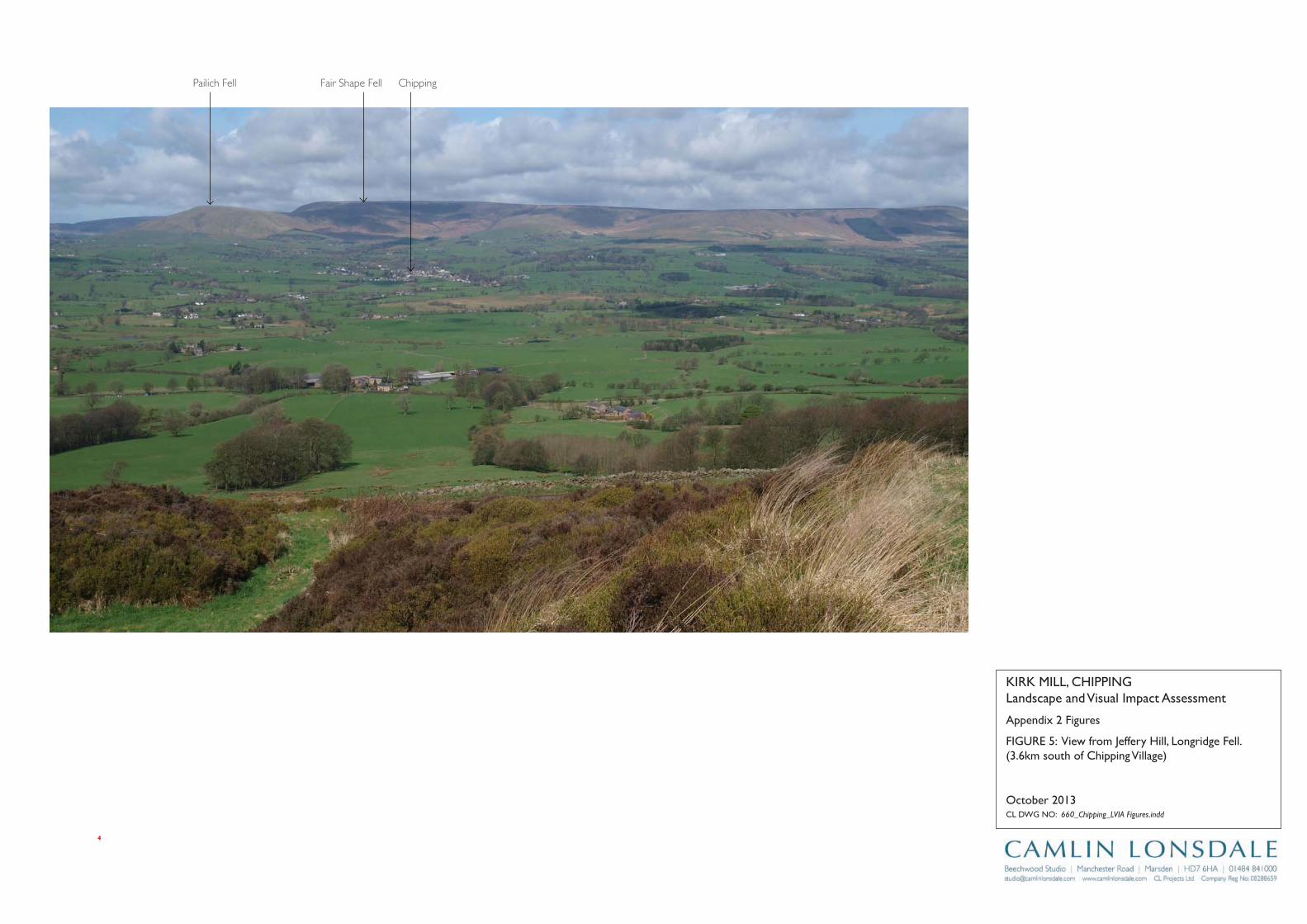
Appendix 2 Figures
KirK Mill, Chippinglandscape and Visual impact Assessment
Cl DWg nO: 660_Chipping_LVIA Figures.indd
October 2013
FigUrE 5: View from Jeffery hill, longridge Fell. (3.6km south of Chipping Village)
4
ChippingFair Shape FellPailich Fell
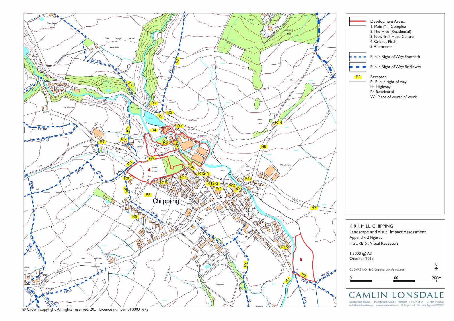
Track
Wharf Farm
Chipping
Brook Bridge
Grove Square
Meadow
Hey
Hawthorns
Track
Issues
Black Hall
Croft
Path
Iss
Isaacs
House
Tk
Pat
h
Drain
Drain
Track
Farm
Works
Sinks
Blackhall
CG
Dairy Barn
Dairy Farm
Drain
Dr ain
Drain
Drain
Drain
Drain
Drain
FB
FB
FB
FB
FB
Fairhaven
Farm
Ferry Butts
Green
Grove
Harling House
Highfield
Hill Clough
Holton Hill
House
Isaac's Farm
Issues
Issues
Issues
Issues
Issues
Issues
Issues
Issues
Issues
Issues
Issues
Issues
Issues
Issues
Issues
Issues
Issues
Issues
Issues
Issues
Issues
Issues
CT
DLEI
FK
OO
RB
DL
EIF
KRI
K
SD
NALK
RIK
CT
SYDEEWT
DLEI
FK
RIK
SD
NALK
OO
RB
KIRK
LAND
S
TE
ERTS
YD
NIW
EN
AL
SWINGLEHURST
DLEIFKRIK
WO
RB
NLI
KTL
AM
TEE
RTS
T
OBLAT
WODAEM
BROAD
RAIKE
CHURCH
LANE
GREEN
EN
ALESUOHHSIF
LANE
HOUSE
KCAL
B
LANE
MOSS
DAOR
GNATSRAG
Issues
Issues
Issues
Issues
Issues
Issues
Issues
Issues
Issues
Issues
Issues
Issues
Issues
Kirk Mills
Lane Ends
Leag
ram
Bro
ok
Lingey Hill
Mill
Moss Side
Nan
Wolfen
Weirs
Weir
Weir
Weir
Weir
Weir
Top O'Saunders
Three
Startifants
Spr
Spr
Spr
Spr
Spr
Spr
Sluice
SlackSinks
Sinks
Sinks
Sinks
Sinks
Sinks
Sinks
Sinks
Sinks
Showground
Pat
h Path
Path
Path
Path
Path
Path
Path
Path
Path
Pat
h
Track
Track
Track
163m
163m
176m
162m
156m
169m
98m
97m
Austin
101m
96m
96m
102m
113m
97m
147m
134m
109m
169m
131m
139m
117m
107m
190m
185m
175m
170m
170m
165m
160m
195 m
155m
150m
145m 14 0m
1 35 m
130m
175m
165m
160m
145m
120m
110m
100m
140m
135m
125m
170m
160m
150m
140m
135m
130m
125m
100m
100m
105m
110m
115m
120m
100m
Holme
Paths
Fish
House
IssPath
Dob
son'
sBr
ook
Path
Path
Path
The Grove
King's Wood
Iss
Nan King's
Farm
Path
Path
Springs
House
Path
GP
After
Lee
Pat h
Sta
Pol
Cricket
Ground
Pav
Old
Hive
Sch
Sch
PW
PO
PW
Vic
The
Field
Iss
Path
Path
Path
Pat h
Abbot
Barn
Clark
House
Path
C h i p p i n gPW
Works
Pat
h
War
Meml
Iss
Iss
Leagram
Lodge
Path
Chi
ppin
gBr
ook
Path
Path
Iss
Brickhouse
Cottage
Issues
Leagram
Hall
IssCottage
Throstle Nest
GP
Cuthbert
Hill
Path
Radcliffe
Hall
Daub
Hall
Little Daub
Hall
The
Croft
Meridor
GP
Sewage
Works
Brookside
High
Head
Goose Lane
Cottages
New
Barnfield
Radcliffe Cottage
High Head
Wood
Valve House
Hotel
Moss Lane
House
125m
Path
Iss
Iss
HallPlaying
Fields
KirK Mill, Chippinglandscape and Visual impact AssessmentAppendix 2 Figures
Cl DWg nO: 660_Chipping_LVIA Figures.inddN
© Crown copyright, All rights reserved. 20..1 licence number 0100031673
1
6
0 100 200m
1:5000 @ A3October 2013
FP 1
FP 125
FP 98
FP88
FP90
FP91
FP15
FP3
FP2
FP1
FP96
FP97FP94
FP14
BW10
FP 95
FP 99
FP 131
FP 30
FP 8
FP 7
2
1
3
4
5
FigUrE : Visual receptors
Development Areas:1. Main Mill Complex2. The hive (residential)3. new Trail head Centre4. Cricket pitch5. Allotments
public right of Way: Footpath
public right of Way: Bridleway
receptor:p: public right of wayh: highwayr: residentialW: place of worship/ work
P2
H6
R13
W1W2
R12-N
R12-S
H4
H2
H1
H3
R11R10
R9
P8
R8
R7R6
R4
R5
R1
R2
R3
P1
P2
P3
P4
P5 H5
H7
R15
P6
P7
H8
R14
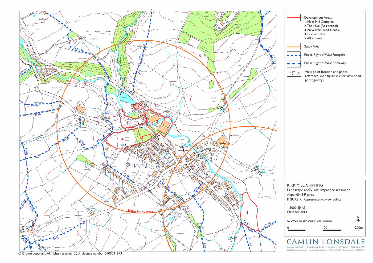
Track
Wharf Farm
Chipping
Brook Bridge
Grove Square
Meadow
Hey
Hawthorns
Track
Issues
Black Hall
Croft
Path
Iss
Isaacs
House
Tk
Pat
h
Drain
Drain
Track
Farm
Works
Sinks
Blackhall
CG
Dairy Barn
Dairy Farm
Drain
Dr ain
Drain
Drain
Drain
Drain
Drain
FB
FB
FB
FB
FB
Fairhaven
Farm
Ferry Butts
Green
Grove
Harling House
Highfield
Hill Clough
Holton Hill
House
Isaac's Farm
Issues
Issues
Issues
Issues
Issues
Issues
Issues
Issues
Issues
Issues
Issues
Issues
Issues
Issues
Issues
Issues
Issues
Issues
Issues
Issues
Issues
Issues
CT
DLEI
FK
OO
RB
DL
EIF
KRI
K
SD
NALK
RIK
CT
SYDEEWT
DLEI
FK
RIK
SD
NALK
OO
RB
KIRK
LAND
S
TE
ERTS
YD
NIW
EN
AL
SWINGLEHURST
DLEIFKRIK
WO
RB
NLI
KTL
AM
TEE
RTS
T
OBLAT
WODAEM
BROAD
RAIKE
CHURCH
LANE
GREEN
EN
ALESUOHHSIF
LANE
HOUSE
KCAL
B
LANE
MOSS
DAOR
GNATSRAG
Issues
Issues
Issues
Issues
Issues
Issues
Issues
Issues
Issues
Issues
Issues
Issues
Issues
Kirk Mills
Lane Ends
Leag
ram
Bro
ok
Lingey Hill
Mill
Moss Side
Nan
Wolfen
Weirs
Weir
Weir
Weir
Weir
Weir
Top O'Saunders
Three
Startifants
Spr
Spr
Spr
Spr
Spr
Spr
Sluice
SlackSinks
Sinks
Sinks
Sinks
Sinks
Sinks
Sinks
Sinks
Sinks
Showground
Pat
h Path
Path
Path
Path
Path
Path
Path
Path
Path
Pat
h
Track
Track
Track
163m
163m
176m
162m
156m
169m
98m
97m
Austin
101m
96m
96m
102m
113m
97m
147m
134m
109m
169m
131m
139m
117m
107m
190m
185m
175m
170m
170m
165m
160m
195 m
155m
150m
145m 14 0m
1 35 m
130m
175m
165m
160m
145m
120m
110m
100m
140m
135m
125m
170m
160m
150m
140m
135m
130m
125m
100m
100m
105m
110m
115m
120m
100m
Holme
Paths
Fish
House
IssPath
Dob
son'
sBr
ook
Path
Path
Path
The Grove
King's Wood
Iss
Nan King's
Farm
Path
Path
Springs
House
Path
GP
After
Lee
Pat h
Sta
Pol
Cricket
Ground
Pav
Old
Hive
Sch
Sch
PW
PO
PW
Vic
The
Field
Iss
Path
Path
Path
Pat h
Abbot
Barn
Clark
House
Path
C h i p p i n gPW
Works
Pat
h
War
Meml
Iss
Iss
Leagram
Lodge
Path
Chi
ppin
gBr
ook
Path
Path
Iss
Brickhouse
Cottage
Issues
Leagram
Hall
IssCottage
Throstle Nest
GP
Cuthbert
Hill
Path
Radcliffe
Hall
Daub
Hall
Little Daub
Hall
The
Croft
Meridor
GP
Sewage
Works
Brookside
High
Head
Goose Lane
Cottages
New
Barnfield
Radcliffe Cottage
High Head
Wood
Valve House
Hotel
Moss Lane
House
125m
Path
Iss
Iss
HallPlaying
Fields
2
KirK Mill, Chippinglandscape and Visual impact AssessmentAppendix 2 Figures
Cl DWg nO: 660_Chipping_LVIA Figures.inddN
© Crown copyright, All rights reserved. 20..1 licence number 0100031673
1
7
0 100 200m
1:5000 @ A3October 2013500m Study Area
FP 1
FP 125
FP 98
FP88
FP90
FP91
FP15
FP3
FP2
FP1
FP96
FP97FP94
FP14
BW10
FP 95
FP 99
FP 131
FP 30
FP 8
FP 7
2
1
3
4
5
FigUrE : representative view points
Development Areas:1. Main Mill Complex2. The hive (residential)3. new Trail head Centre4. Cricket pitch5. Allotments
Study Area
public right of Way: Footpath
public right of Way: Bridleway
View point location and photo reference (See figure x-x for view point photography)
1
2
4
3
9
8
10
11
12
13 14
15
16
17
19
18
20
21
22
67
5

Track
Wharf Farm
Chipping
Brook Bridge
Grove Square
Meadow
Hey
Hawthorns
Track
Issues
Black Hall
Croft
Path
Iss
Isaacs
House
Tk
Pat
h
Drain
Drain
Track
Farm
Works
Sinks
Blackhall
CG
Dairy Barn
Dairy Farm
Drain
Dr ain
Drain
Drain
Drain
Drain
Drain
FB
FB
FB
FB
FB
Fairhaven
Farm
Ferry Butts
Green
Grove
Harling House
Highfield
Hill Clough
Holton Hill
House
Isaac's Farm
Issues
Issues
Issues
Issues
Issues
Issues
Issues
Issues
Issues
Issues
Issues
Issues
Issues
Issues
Issues
Issues
Issues
Issues
Issues
Issues
Issues
Issues
CT
DLEI
FK
OO
RB
DL
EIF
KRI
K
SD
NALK
RIK
CT
SYDEEWT
DLEI
FK
RIK
SD
NALK
OO
RB
KIRK
LAND
S
TE
ERTS
YD
NIW
EN
AL
SWINGLEHURST
DLEIFKRIK
WO
RB
NLI
KTL
AM
TEE
RTS
T
OBLAT
WODAEM
BROAD
RAIKE
CHURCH
LANE
GREEN
EN
ALESUOHHSIF
LANE
HOUSE
KCAL
B
LANE
MOSS
DAOR
GNATSRAG
Issues
Issues
Issues
Issues
Issues
Issues
Issues
Issues
Issues
Issues
Issues
Issues
Issues
Kirk Mills
Lane Ends
Leag
ram
Bro
ok
Lingey Hill
Mill
Moss Side
Nan
Wolfen
Weirs
Weir
Weir
Weir
Weir
Weir
Top O'Saunders
Three
Startifants
Spr
Spr
Spr
Spr
Spr
Spr
Sluice
SlackSinks
Sinks
Sinks
Sinks
Sinks
Sinks
Sinks
Sinks
Sinks
Showground
Pat
h Path
Path
Path
Path
Path
Path
Path
Path
Path
Pat
h
Track
Track
Track
163m
163m
176m
162m
156m
169m
98m
97m
Austin
101m
96m
96m
102m
113m
97m
147m
134m
109m
169m
131m
139m
117m
107m
190m
185m
175m
170m
170m
165m
160m
195 m
155m
150m
145m 14 0m
1 35 m
130m
175m
165m
160m
145m
120m
110m
100m
140m
135m
125m
170m
160m
150m
140m
135m
130m
125m
100m
100m
105m
110m
115m
120m
100m
Holme
Paths
Fish
House
IssPath
Dob
son'
sBr
ook
Path
Path
Path
The Grove
King's Wood
Iss
Nan King's
Farm
Path
Path
Springs
House
Path
GP
After
Lee
Pat h
Sta
Pol
Cricket
Ground
Pav
Old
Hive
Sch
Sch
PW
PO
PW
Vic
The
Field
Iss
Path
Path
Path
Pat h
Abbot
Barn
Clark
House
Path
C h i p p i n gPW
Works
Pat
h
War
Meml
Iss
Iss
Leagram
Lodge
Path
Chi
ppin
gBr
ook
Path
Path
Iss
Brickhouse
Cottage
Issues
Leagram
Hall
IssCottage
Throstle Nest
GP
Cuthbert
Hill
Path
Radcliffe
Hall
Daub
Hall
Little Daub
Hall
The
Croft
Meridor
GP
Sewage
Works
Brookside
High
Head
Goose Lane
Cottages
New
Barnfield
Radcliffe Cottage
High Head
Wood
Valve House
Hotel
Moss Lane
House
125m
Path
Iss
Iss
HallPlaying
Fields
1
Appendix 2 Figures
KirK Mill, Chippinglandscape and Visual impact Assessment
Cl DWg nO: 660_Chipping_LVIA Figures.indd
October 2013
proposed development within photograph:External works associated with Kirk Mill (Listed Building)
Existing View:Kirk Mill pond forms a key focal point to the view. The rear elevation of Kirk Mill and upper section of the riverside crane is visible in the middle distance
predicted Visibility: Self seeded trees on mill dam bank to be removed
Viewpoint Data:
OS Grid reference: 6185 4370Date: 7 May 2013
Height above ground: 1.70mCamera and Lens: Digital SLR with fixed lens 50mm equivalentCorrect viewing: Pan across image at viewing distance of approximately 500mm (at A3)
View south east along Malt Kiln Brow from Austin house
FigUrE 8ViEW pOinT 660/1
2
1
3
4
Kirk MillLongside Fell Kirk House
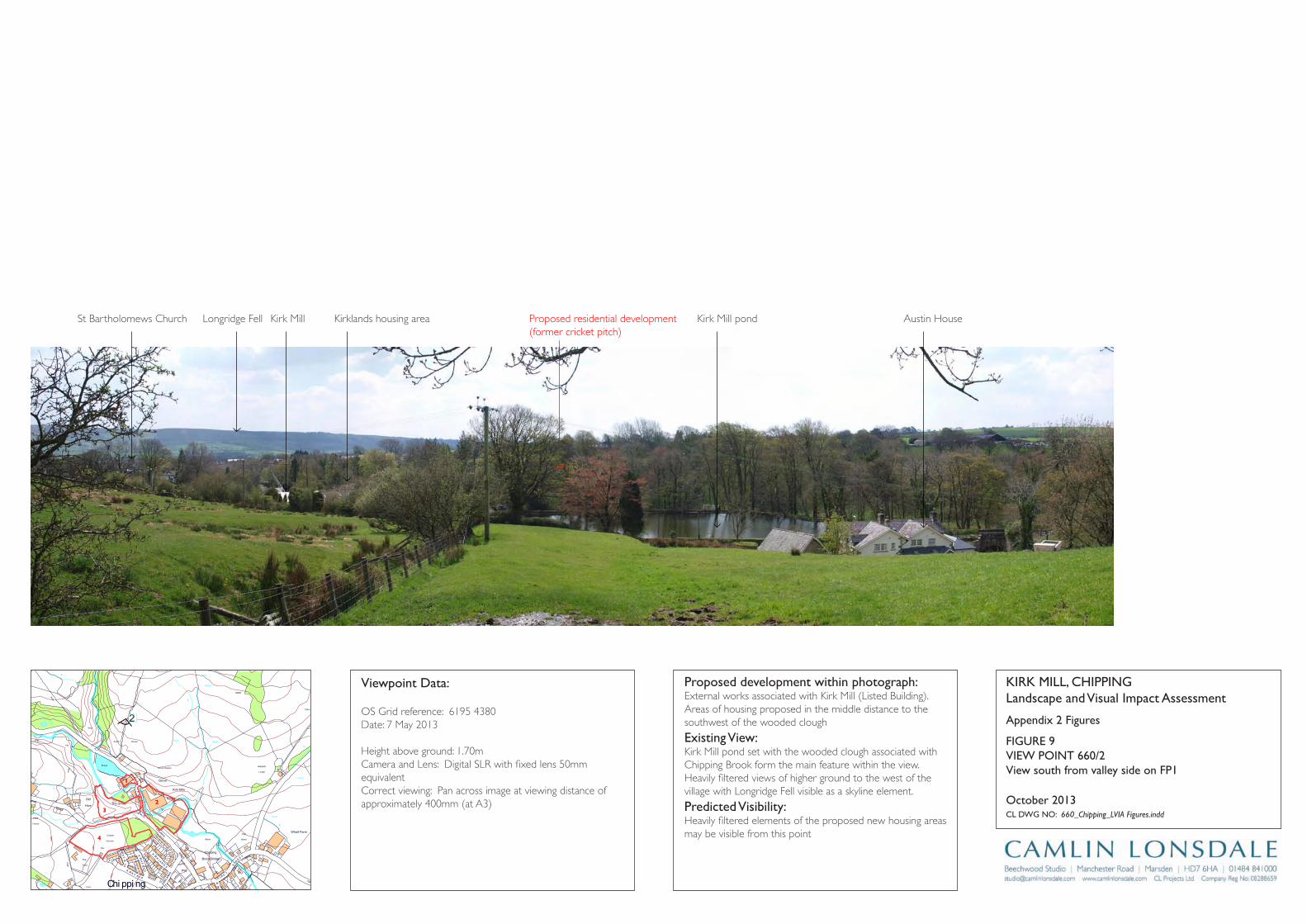
Track
Wharf Farm
Chipping
Brook Bridge
Grove Square
Meadow
Hey
Hawthorns
Track
Issues
Black Hall
Croft
Path
Iss
Isaacs
House
Tk
Pat
h
Drain
Drain
Track
Farm
Works
Sinks
Blackhall
CG
Dairy Barn
Dairy Farm
Drain
Dr ain
Drain
Drain
Drain
Drain
Drain
FB
FB
FB
FB
FB
Fairhaven
Farm
Ferry Butts
Green
Grove
Harling House
Highfield
Hill Clough
Holton Hill
House
Isaac's Farm
Issues
Issues
Issues
Issues
Issues
Issues
Issues
Issues
Issues
Issues
Issues
Issues
Issues
Issues
Issues
Issues
Issues
Issues
Issues
Issues
Issues
Issues
CT
DLEI
FK
OO
RB
DL
EIF
KRI
K
SD
NALK
RIK
CT
SYDEEWT
DLEI
FK
RIK
SD
NALK
OO
RB
KIRK
LAND
S
TE
ERTS
YD
NIW
EN
AL
SWINGLEHURST
DLEIFKRIK
WO
RB
NLI
KTL
AM
TEE
RTS
T
OBLAT
WODAEM
BROAD
RAIKE
CHURCH
LANE
GREEN
EN
ALESUOHHSIF
LANE
HOUSE
KCAL
B
LANE
MOSS
DAOR
GNATSRAG
Issues
Issues
Issues
Issues
Issues
Issues
Issues
Issues
Issues
Issues
Issues
Issues
Issues
Kirk Mills
Lane Ends
Leag
ram
Bro
ok
Lingey Hill
Mill
Moss Side
Nan
Wolfen
Weirs
Weir
Weir
Weir
Weir
Weir
Top O'Saunders
Three
Startifants
Spr
Spr
Spr
Spr
Spr
Spr
Sluice
SlackSinks
Sinks
Sinks
Sinks
Sinks
Sinks
Sinks
Sinks
Sinks
Showground
Pat
h Path
Path
Path
Path
Path
Path
Path
Path
Path
Pat
h
Track
Track
Track
163m
163m
176m
162m
156m
169m
98m
97m
Austin
101m
96m
96m
102m
113m
97m
147m
134m
109m
169m
131m
139m
117m
107m
190m
185m
175m
170m
170m
165m
160m
195 m
155m
150m
145m 14 0m
1 35 m
130m
175m
165m
160m
145m
120m
110m
100m
140m
135m
125m
170m
160m
150m
140m
135m
130m
125m
100m
100m
105m
110m
115m
120m
100m
Holme
Paths
Fish
House
IssPath
Dob
son'
sBr
ook
Path
Path
Path
The Grove
King's Wood
Iss
Nan King's
Farm
Path
Path
Springs
House
Path
GP
After
Lee
Pat h
Sta
Pol
Cricket
Ground
Pav
Old
Hive
Sch
Sch
PW
PO
PW
Vic
The
Field
Iss
Path
Path
Path
Pat h
Abbot
Barn
Clark
House
Path
C h i p p i n gPW
Works
Pat
h
War
Meml
Iss
Iss
Leagram
Lodge
Path
Chi
ppin
gBr
ook
Path
Path
Iss
Brickhouse
Cottage
Issues
Leagram
Hall
IssCottage
Throstle Nest
GP
Cuthbert
Hill
Path
Radcliffe
Hall
Daub
Hall
Little Daub
Hall
The
Croft
Meridor
GP
Sewage
Works
Brookside
High
Head
Goose Lane
Cottages
New
Barnfield
Radcliffe Cottage
High Head
Wood
Valve House
Hotel
Moss Lane
House
125m
Path
Iss
Iss
HallPlaying
Fields
2 Appendix 2 Figures
KirK Mill, Chippinglandscape and Visual impact Assessment
Cl DWg nO: 660_Chipping_LVIA Figures.indd
October 2013
proposed development within photograph:External works associated with Kirk Mill (Listed Building). Areas of housing proposed in the middle distance to the southwest of the wooded clough
Existing View:Kirk Mill pond set with the wooded clough associated with Chipping Brook form the main feature within the view. Heavily filtered views of higher ground to the west of the village with Longridge Fell visible as a skyline element.
predicted Visibility: Heavily filtered elements of the proposed new housing areas may be visible from this point
Viewpoint Data:
OS Grid reference: 6195 4380Date: 7 May 2013
Height above ground: 1.70mCamera and Lens: Digital SLR with fixed lens 50mm equivalentCorrect viewing: Pan across image at viewing distance of approximately 400mm (at A3)
View south from valley side on Fp1
FigUrE 9ViEW pOinT 660/2
2
1
3
4
Proposed residential development(former cricket pitch)
St Bartholomews Church Longridge Fell Kirk Mill Kirklands housing area Kirk Mill pond Austin House
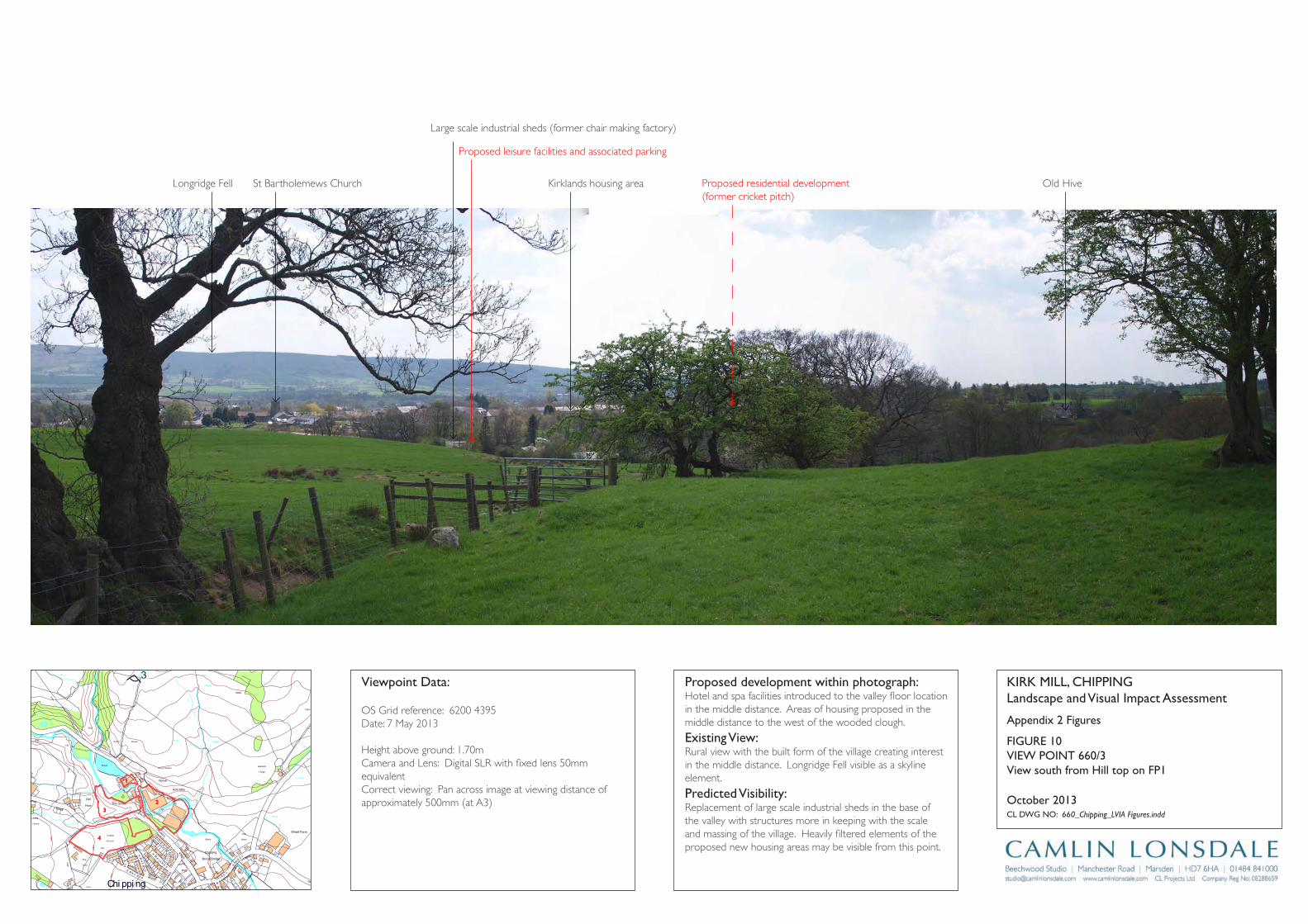
Track
Wharf Farm
Chipping
Brook Bridge
Grove Square
Meadow
Hey
Hawthorns
Track
Issues
Black Hall
Croft
Path
Iss
Isaacs
House
Tk
Pat
h
Drain
Drain
Track
Farm
Works
Sinks
Blackhall
CG
Dairy Barn
Dairy Farm
Drain
Dr ain
Drain
Drain
Drain
Drain
Drain
FB
FB
FB
FB
FB
Fairhaven
Farm
Ferry Butts
Green
Grove
Harling House
Highfield
Hill Clough
Holton Hill
House
Isaac's Farm
Issues
Issues
Issues
Issues
Issues
Issues
Issues
Issues
Issues
Issues
Issues
Issues
Issues
Issues
Issues
Issues
Issues
Issues
Issues
Issues
Issues
Issues
CT
DLEI
FK
OO
RB
DL
EIF
KRI
K
SD
NALK
RIK
CT
SYDEEWT
DLEI
FK
RIK
SD
NALK
OO
RB
KIRK
LAND
S
TE
ERTS
YD
NIW
EN
AL
SWINGLEHURST
DLEIFKRIK
WO
RB
NLI
KTL
AM
TEE
RTS
T
OBLAT
WODAEM
BROAD
RAIKE
CHURCH
LANE
GREEN
EN
ALESUOHHSIF
LANE
HOUSE
KCAL
B
LANE
MOSS
DAOR
GNATSRAG
Issues
Issues
Issues
Issues
Issues
Issues
Issues
Issues
Issues
Issues
Issues
Issues
Issues
Kirk Mills
Lane Ends
Leag
ram
Bro
ok
Lingey Hill
Mill
Moss Side
Nan
Wolfen
Weirs
Weir
Weir
Weir
Weir
Weir
Top O'Saunders
Three
Startifants
Spr
Spr
Spr
Spr
Spr
Spr
Sluice
SlackSinks
Sinks
Sinks
Sinks
Sinks
Sinks
Sinks
Sinks
Sinks
Showground
Pat
h Path
Path
Path
Path
Path
Path
Path
Path
Path
Pat
h
Track
Track
Track
163m
163m
176m
162m
156m
169m
98m
97m
Austin
101m
96m
96m
102m
113m
97m
147m
134m
109m
169m
131m
139m
117m
107m
190m
185m
175m
170m
170m
165m
160m
195 m
155m
150m
145m 14 0m
1 35 m
130m
175m
165m
160m
145m
120m
110m
100m
140m
135m
125m
170m
160m
150m
140m
135m
130m
125m
100m
100m
105m
110m
115m
120m
100m
Holme
Paths
Fish
House
IssPath
Dob
son'
sBr
ook
Path
Path
Path
The Grove
King's Wood
Iss
Nan King's
Farm
Path
Path
Springs
House
Path
GP
After
Lee
Pat h
Sta
Pol
Cricket
Ground
Pav
Old
Hive
Sch
Sch
PW
PO
PW
Vic
The
Field
Iss
Path
Path
Path
Pat h
Abbot
Barn
Clark
House
Path
C h i p p i n gPW
Works
Pat
h
War
Meml
Iss
Iss
Leagram
Lodge
Path
Chi
ppin
gBr
ook
Path
Path
Iss
Brickhouse
Cottage
Issues
Leagram
Hall
IssCottage
Throstle Nest
GP
Cuthbert
Hill
Path
Radcliffe
Hall
Daub
Hall
Little Daub
Hall
The
Croft
Meridor
GP
Sewage
Works
Brookside
High
Head
Goose Lane
Cottages
New
Barnfield
Radcliffe Cottage
High Head
Wood
Valve House
Hotel
Moss Lane
House
125m
Path
Iss
Iss
HallPlaying
Fields
3
Appendix 2 Figures
KirK Mill, Chippinglandscape and Visual impact Assessment
Cl DWg nO: 660_Chipping_LVIA Figures.indd
October 2013
proposed development within photograph:Hotel and spa facilities introduced to the valley floor location in the middle distance. Areas of housing proposed in the middle distance to the west of the wooded clough.
Existing View:Rural view with the built form of the village creating interest in the middle distance. Longridge Fell visible as a skyline element.
predicted Visibility: Replacement of large scale industrial sheds in the base of the valley with structures more in keeping with the scale and massing of the village. Heavily filtered elements of the proposed new housing areas may be visible from this point.
Viewpoint Data:
OS Grid reference: 6200 4395Date: 7 May 2013
Height above ground: 1.70mCamera and Lens: Digital SLR with fixed lens 50mm equivalentCorrect viewing: Pan across image at viewing distance of approximately 500mm (at A3)
View south from hill top on Fp1
FigUrE 10ViEW pOinT 660/3
2
1
3
4
Proposed leisure facilities and associated parking
Proposed residential development(former cricket pitch)
Longridge Fell St Bartholemews Church Kirklands housing area
Large scale industrial sheds (former chair making factory)
Old Hive
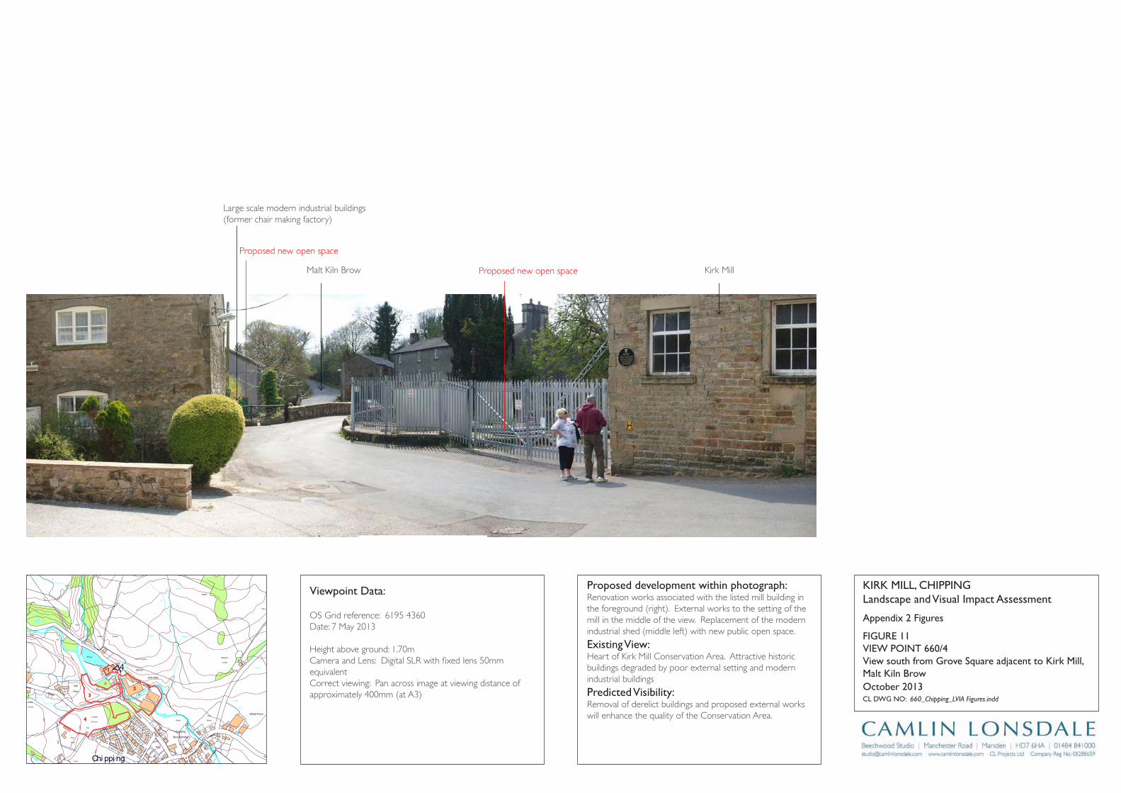
Track
Wharf Farm
Chipping
Brook Bridge
Grove Square
Meadow
Hey
Hawthorns
Track
Issues
Black Hall
Croft
Path
Iss
Isaacs
House
Tk
Pat
h
Drain
Drain
Track
Farm
Works
Sinks
Blackhall
CG
Dairy Barn
Dairy Farm
Drain
Dr ain
Drain
Drain
Drain
Drain
Drain
FB
FB
FB
FB
FB
Fairhaven
Farm
Ferry Butts
Green
Grove
Harling House
Highfield
Hill Clough
Holton Hill
House
Isaac's Farm
Issues
Issues
Issues
Issues
Issues
Issues
Issues
Issues
Issues
Issues
Issues
Issues
Issues
Issues
Issues
Issues
Issues
Issues
Issues
Issues
Issues
Issues
CT
DLEI
FK
OO
RB
DL
EIF
KRI
K
SD
NALK
RIK
CT
SYDEEWT
DLEI
FK
RIK
SD
NALK
OO
RB
KIRK
LAND
S
TE
ERTS
YD
NIW
EN
AL
SWINGLEHURST
DLEIFKRIK
WO
RB
NLI
KTL
AM
TEE
RTS
T
OBLAT
WODAEM
BROAD
RAIKE
CHURCH
LANE
GREEN
EN
ALESUOHHSIF
LANE
HOUSE
KCAL
B
LANE
MOSS
DAOR
GNATSRAG
Issues
Issues
Issues
Issues
Issues
Issues
Issues
Issues
Issues
Issues
Issues
Issues
Issues
Kirk Mills
Lane Ends
Leag
ram
Bro
ok
Lingey Hill
Mill
Moss Side
Nan
Wolfen
Weirs
Weir
Weir
Weir
Weir
Weir
Top O'Saunders
Three
Startifants
Spr
Spr
Spr
Spr
Spr
Spr
Sluice
SlackSinks
Sinks
Sinks
Sinks
Sinks
Sinks
Sinks
Sinks
Sinks
Showground
Pat
h Path
Path
Path
Path
Path
Path
Path
Path
Path
Pat
h
Track
Track
Track
163m
163m
176m
162m
156m
169m
98m
97m
Austin
101m
96m
96m
102m
113m
97m
147m
134m
109m
169m
131m
139m
117m
107m
190m
185m
175m
170m
170m
165m
160m
195 m
155m
150m
145m 14 0m
1 35 m
130m
175m
165m
160m
145m
120m
110m
100m
140m
135m
125m
170m
160m
150m
140m
135m
130m
125m
100m
100m
105m
110m
115m
120m
100m
Holme
Paths
Fish
House
IssPath
Dob
son'
sBr
ook
Path
Path
Path
The Grove
King's Wood
Iss
Nan King's
Farm
Path
Path
Springs
House
Path
GP
After
Lee
Pat h
Sta
Pol
Cricket
Ground
Pav
Old
Hive
Sch
Sch
PW
PO
PW
Vic
The
Field
Iss
Path
Path
Path
Pat h
Abbot
Barn
Clark
House
Path
C h i p p i n gPW
Works
Pat
h
War
Meml
Iss
Iss
Leagram
Lodge
Path
Chi
ppin
gBr
ook
Path
Path
Iss
Brickhouse
Cottage
Issues
Leagram
Hall
IssCottage
Throstle Nest
GP
Cuthbert
Hill
Path
Radcliffe
Hall
Daub
Hall
Little Daub
Hall
The
Croft
Meridor
GP
Sewage
Works
Brookside
High
Head
Goose Lane
Cottages
New
Barnfield
Radcliffe Cottage
High Head
Wood
Valve House
Hotel
Moss Lane
House
125m
Path
Iss
Iss
HallPlaying
Fields
4
Appendix 2 Figures
KirK Mill, Chippinglandscape and Visual impact Assessment
Cl DWg nO: 660_Chipping_LVIA Figures.indd
October 2013
proposed development within photograph:Renovation works associated with the listed mill building in the foreground (right). External works to the setting of the mill in the middle of the view. Replacement of the modern industrial shed (middle left) with new public open space.
Existing View:Heart of Kirk Mill Conservation Area. Attractive historic buildings degraded by poor external setting and modern industrial buildings
predicted Visibility: Removal of derelict buildings and proposed external works will enhance the quality of the Conservation Area.
Viewpoint Data:
OS Grid reference: 6195 4360Date: 7 May 2013
Height above ground: 1.70mCamera and Lens: Digital SLR with fixed lens 50mm equivalentCorrect viewing: Pan across image at viewing distance of approximately 400mm (at A3)
View south from grove Square adjacent to Kirk Mill, Malt Kiln Brow
FigUrE 11ViEW pOinT 660/4
2
1
3
4
Proposed new open space
Proposed new open space
Malt Kiln Brow
Large scale modern industrial buildings(former chair making factory)
Kirk Mill
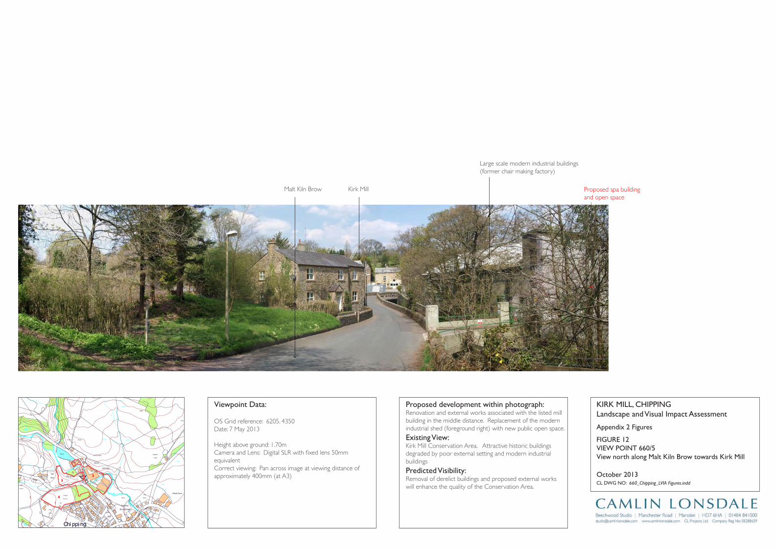
Track
Wharf Farm
Chipping
Brook Bridge
Grove Square
Meadow
Hey
Hawthorns
Track
Issues
Black Hall
Croft
Path
Iss
Isaacs
House
Tk
Pat
h
Drain
Drain
Track
Farm
Works
Sinks
Blackhall
CG
Dairy Barn
Dairy Farm
Drain
Dr ain
Drain
Drain
Drain
Drain
Drain
FB
FB
FB
FB
FB
Fairhaven
Farm
Ferry Butts
Green
Grove
Harling House
Highfield
Hill Clough
Holton Hill
House
Isaac's Farm
Issues
Issues
Issues
Issues
Issues
Issues
Issues
Issues
Issues
Issues
Issues
Issues
Issues
Issues
Issues
Issues
Issues
Issues
Issues
Issues
Issues
Issues
CT
DLEI
FK
OO
RB
DL
EIF
KRI
K
SD
NALK
RIK
CT
SYDEEWT
DLEI
FK
RIK
SD
NALK
OO
RB
KIRK
LAND
S
TE
ERTS
YD
NIW
EN
AL
SWINGLEHURST
DLEIFKRIK
WO
RB
NLI
KTL
AM
TEE
RTS
T
OBLAT
WODAEM
BROAD
RAIKE
CHURCH
LANE
GREEN
EN
ALESUOHHSIF
LANE
HOUSE
KCAL
B
LANE
MOSS
DAOR
GNATSRAG
Issues
Issues
Issues
Issues
Issues
Issues
Issues
Issues
Issues
Issues
Issues
Issues
Issues
Kirk Mills
Lane Ends
Leag
ram
Bro
ok
Lingey Hill
Mill
Moss Side
Nan
Wolfen
Weirs
Weir
Weir
Weir
Weir
Weir
Top O'Saunders
Three
Startifants
Spr
Spr
Spr
Spr
Spr
Spr
Sluice
SlackSinks
Sinks
Sinks
Sinks
Sinks
Sinks
Sinks
Sinks
Sinks
Showground
Pat
h Path
Path
Path
Path
Path
Path
Path
Path
Path
Pat
h
Track
Track
Track
163m
163m
176m
162m
156m
169m
98m
97m
Austin
101m
96m
96m
102m
113m
97m
147m
134m
109m
169m
131m
139m
117m
107m
190m
185m
175m
170m
170m
165m
160m
195 m
155m
150m
145m 14 0m
1 35 m
130m
175m
165m
160m
145m
120m
110m
100m
140m
135m
125m
170m
160m
150m
140m
135m
130m
125m
100m
100m
105m
110m
115m
120m
100m
Holme
Paths
Fish
House
IssPath
Dob
son'
sBr
ook
Path
Path
Path
The Grove
King's Wood
Iss
Nan King's
Farm
Path
Path
Springs
House
Path
GP
After
Lee
Pat h
Sta
Pol
Cricket
Ground
Pav
Old
Hive
Sch
Sch
PW
PO
PW
Vic
The
Field
Iss
Path
Path
Path
Pat h
Abbot
Barn
Clark
House
Path
C h i p p i n gPW
Works
Pat
h
War
Meml
Iss
Iss
Leagram
Lodge
Path
Chi
ppin
gBr
ook
Path
Path
Iss
Brickhouse
Cottage
Issues
Leagram
Hall
IssCottage
Throstle Nest
GP
Cuthbert
Hill
Path
Radcliffe
Hall
Daub
Hall
Little Daub
Hall
The
Croft
Meridor
GP
Sewage
Works
Brookside
High
Head
Goose Lane
Cottages
New
Barnfield
Radcliffe Cottage
High Head
Wood
Valve House
Hotel
Moss Lane
House
125m
Path
Iss
Iss
HallPlaying
Fields
5
Appendix 2 Figures
KirK Mill, Chippinglandscape and Visual impact Assessment
Cl DWg nO: 660_Chipping_LVIA Figures.indd
October 2013
proposed development within photograph:Renovation and external works associated with the listed mill building in the middle distance. Replacement of the modern industrial shed (foreground right) with new public open space.
Existing View:Kirk Mill Conservation Area. Attractive historic buildings degraded by poor external setting and modern industrial buildings
predicted Visibility: Removal of derelict buildings and proposed external works will enhance the quality of the Conservation Area.
Viewpoint Data:
OS Grid reference: 6205. 4350Date: 7 May 2013
Height above ground: 1.70mCamera and Lens: Digital SLR with fixed lens 50mm equivalentCorrect viewing: Pan across image at viewing distance of approximately 400mm (at A3)
View north along Malt Kiln Brow towards Kirk Mill
FigUrE 12ViEW pOinT 660/5
2
1
3
4
Proposed spa building and open space
Kirk MillMalt Kiln Brow
Large scale modern industrial buildings(former chair making factory)
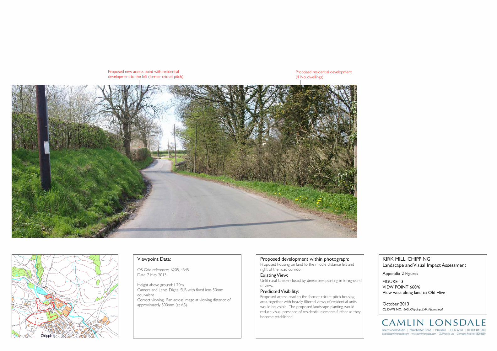
Track
Wharf Farm
Chipping
Brook Bridge
Grove Square
Meadow
Hey
Hawthorns
Track
Issues
Black Hall
Croft
Path
Iss
Isaacs
House
Tk
Pat
h
Drain
Drain
Track
Farm
Works
Sinks
Blackhall
CG
Dairy Barn
Dairy Farm
Drain
Dr ain
Drain
Drain
Drain
Drain
Drain
FB
FB
FB
FB
FB
Fairhaven
Farm
Ferry Butts
Green
Grove
Harling House
Highfield
Hill Clough
Holton Hill
House
Isaac's Farm
Issues
Issues
Issues
Issues
Issues
Issues
Issues
Issues
Issues
Issues
Issues
Issues
Issues
Issues
Issues
Issues
Issues
Issues
Issues
Issues
Issues
Issues
CT
DLEI
FK
OO
RB
DL
EIF
KRI
K
SD
NALK
RIK
CT
SYDEEWT
DLEI
FK
RIK
SD
NALK
OO
RB
KIRK
LAND
S
TE
ERTS
YD
NIW
EN
AL
SWINGLEHURST
DLEIFKRIK
WO
RB
NLI
KTL
AM
TEE
RTS
T
OBLAT
WODAEM
BROAD
RAIKE
CHURCH
LANE
GREEN
EN
ALESUOHHSIF
LANE
HOUSE
KCAL
B
LANE
MOSS
DAOR
GNATSRAG
Issues
Issues
Issues
Issues
Issues
Issues
Issues
Issues
Issues
Issues
Issues
Issues
Issues
Kirk Mills
Lane Ends
Leag
ram
Bro
ok
Lingey Hill
Mill
Moss Side
Nan
Wolfen
Weirs
Weir
Weir
Weir
Weir
Weir
Top O'Saunders
Three
Startifants
Spr
Spr
Spr
Spr
Spr
Spr
Sluice
SlackSinks
Sinks
Sinks
Sinks
Sinks
Sinks
Sinks
Sinks
Sinks
Showground
Pat
h Path
Path
Path
Path
Path
Path
Path
Path
Path
Pat
h
Track
Track
Track
163m
163m
176m
162m
156m
169m
98m
97m
Austin
101m
96m
96m
102m
113m
97m
147m
134m
109m
169m
131m
139m
117m
107m
190m
185m
175m
170m
170m
165m
160m
195 m
155m
150m
145m 14 0m
1 35 m
130m
175m
165m
160m
145m
120m
110m
100m
140m
135m
125m
170m
160m
150m
140m
135m
130m
125m
100m
100m
105m
110m
115m
120m
100m
Holme
Paths
Fish
House
IssPath
Dob
son'
sBr
ook
Path
Path
Path
The Grove
King's Wood
Iss
Nan King's
Farm
Path
Path
Springs
House
Path
GP
After
Lee
Pat h
Sta
Pol
Cricket
Ground
Pav
Old
Hive
Sch
Sch
PW
PO
PW
Vic
The
Field
Iss
Path
Path
Path
Pat h
Abbot
Barn
Clark
House
Path
C h i p p i n gPW
Works
Pat
h
War
Meml
Iss
Iss
Leagram
Lodge
Path
Chi
ppin
gBr
ook
Path
Path
Iss
Brickhouse
Cottage
Issues
Leagram
Hall
IssCottage
Throstle Nest
GP
Cuthbert
Hill
Path
Radcliffe
Hall
Daub
Hall
Little Daub
Hall
The
Croft
Meridor
GP
Sewage
Works
Brookside
High
Head
Goose Lane
Cottages
New
Barnfield
Radcliffe Cottage
High Head
Wood
Valve House
Hotel
Moss Lane
House
125m
Path
Iss
Iss
HallPlaying
Fields
6
Appendix 2 Figures
KirK Mill, Chippinglandscape and Visual impact Assessment
Cl DWg nO: 660_Chipping_LVIA Figures.indd
October 2013
proposed development within photograph:Proposed housing on land to the middle distance left and right of the road corridor
Existing View:Unlit rural lane, enclosed by dense tree planting in foreground of view.
predicted Visibility: Proposed access road to the former cricket pitch housing area, together with heavily filtered views of residential units would be visible. The proposed landscape planting would reduce visual presence of residential elements further as they become established.
Viewpoint Data:
OS Grid reference: 6205. 4345Date: 7 May 2013
Height above ground: 1.70mCamera and Lens: Digital SLR with fixed lens 50mm equivalentCorrect viewing: Pan across image at viewing distance of approximately 500mm (at A3)
View west along lane to Old hive
FigUrE 13ViEW pOinT 660/6
2
1
3
4
Proposed new access point with residential development to the left (former cricket pitch)
Proposed residential development(4 No. dwellings)
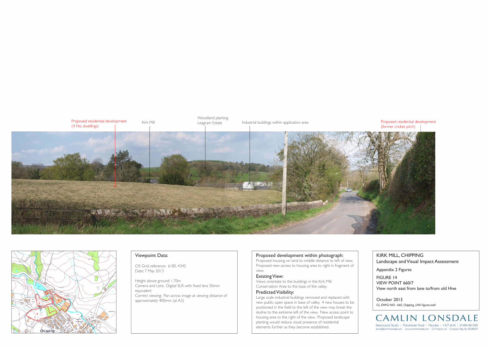
Track
Wharf Farm
Chipping
Brook Bridge
Grove Square
Meadow
Hey
Hawthorns
Track
Issues
Black Hall
Croft
Path
Iss
Isaacs
House
Tk
Pat
h
Drain
Drain
Track
Farm
Works
Sinks
Blackhall
CG
Dairy Barn
Dairy Farm
Drain
Dr ain
Drain
Drain
Drain
Drain
Drain
FB
FB
FB
FB
FB
Fairhaven
Farm
Ferry Butts
Green
Grove
Harling House
Highfield
Hill Clough
Holton Hill
House
Isaac's Farm
Issues
Issues
Issues
Issues
Issues
Issues
Issues
Issues
Issues
Issues
Issues
Issues
Issues
Issues
Issues
Issues
Issues
Issues
Issues
Issues
Issues
Issues
CT
DLEI
FK
OO
RB
DL
EIF
KRI
K
SD
NALK
RIK
CT
SYDEEWT
DLEI
FK
RIK
SD
NALK
OO
RB
KIRK
LAND
S
TE
ERTS
YD
NIW
EN
AL
SWINGLEHURST
DLEIFKRIK
WO
RB
NLI
KTL
AM
TEE
RTS
T
OBLAT
WODAEM
BROAD
RAIKE
CHURCH
LANE
GREEN
EN
ALESUOHHSIF
LANE
HOUSE
KCAL
B
LANE
MOSS
DAOR
GNATSRAG
Issues
Issues
Issues
Issues
Issues
Issues
Issues
Issues
Issues
Issues
Issues
Issues
Issues
Kirk Mills
Lane Ends
Leag
ram
Bro
ok
Lingey Hill
Mill
Moss Side
Nan
Wolfen
Weirs
Weir
Weir
Weir
Weir
Weir
Top O'Saunders
Three
Startifants
Spr
Spr
Spr
Spr
Spr
Spr
Sluice
SlackSinks
Sinks
Sinks
Sinks
Sinks
Sinks
Sinks
Sinks
Sinks
Showground
Pat
h Path
Path
Path
Path
Path
Path
Path
Path
Path
Pat
h
Track
Track
Track
163m
163m
176m
162m
156m
169m
98m
97m
Austin
101m
96m
96m
102m
113m
97m
147m
134m
109m
169m
131m
139m
117m
107m
190m
185m
175m
170m
170m
165m
160m
195 m
155m
150m
145m 14 0m
1 35 m
130m
175m
165m
160m
145m
120m
110m
100m
140m
135m
125m
170m
160m
150m
140m
135m
130m
125m
100m
100m
105m
110m
115m
120m
100m
Holme
Paths
Fish
House
IssPath
Dob
son'
sBr
ook
Path
Path
Path
The Grove
King's Wood
Iss
Nan King's
Farm
Path
Path
Springs
House
Path
GP
After
Lee
Pat h
Sta
Pol
Cricket
Ground
Pav
Old
Hive
Sch
Sch
PW
PO
PW
Vic
The
Field
Iss
Path
Path
Path
Pat h
Abbot
Barn
Clark
House
Path
C h i p p i n gPW
Works
Pat
h
War
Meml
Iss
Iss
Leagram
Lodge
Path
Chi
ppin
gBr
ook
Path
Path
Iss
Brickhouse
Cottage
Issues
Leagram
Hall
IssCottage
Throstle Nest
GP
Cuthbert
Hill
Path
Radcliffe
Hall
Daub
Hall
Little Daub
Hall
The
Croft
Meridor
GP
Sewage
Works
Brookside
High
Head
Goose Lane
Cottages
New
Barnfield
Radcliffe Cottage
High Head
Wood
Valve House
Hotel
Moss Lane
House
125m
Path
Iss
Iss
HallPlaying
Fields
7
Appendix 2 Figures
KirK Mill, Chippinglandscape and Visual impact Assessment
Cl DWg nO: 660_Chipping_LVIA Figures.indd
October 2013
proposed development within photograph:Proposed housing on land to middle distance to left of view. Proposed new access to housing area to right in fragment of view.
Existing View:Views orientate to the buildings in the Kirk Mill Conservation Area to the base of the valley.
predicted Visibility: Large scale industrial buildings removed and replaced with new public open space in base of valley. 4 new houses to be positioned in the field to the left of the view may break the skyline to the extreme left of the view. New access point to housing area to the right of the view. Proposed landscape planting would reduce visual presence of residential elements further as they become established.
Viewpoint Data:
OS Grid reference: 6185. 4345Date: 7 May 2013
Height above ground: 1.70mCamera and Lens: Digital SLR with fixed lens 50mm equivalentCorrect viewing: Pan across image at viewing distance of approximately 400mm (at A3)
View north east from lane to/from old hive
FigUrE 14ViEW pOinT 660/7
2
1
3
4
Proposed residential development(4 No. dwellings)
Proposed residential development(former cricket pitch)
Kirk MillWoodland planting Leagram Estate Industrial buildings within application area
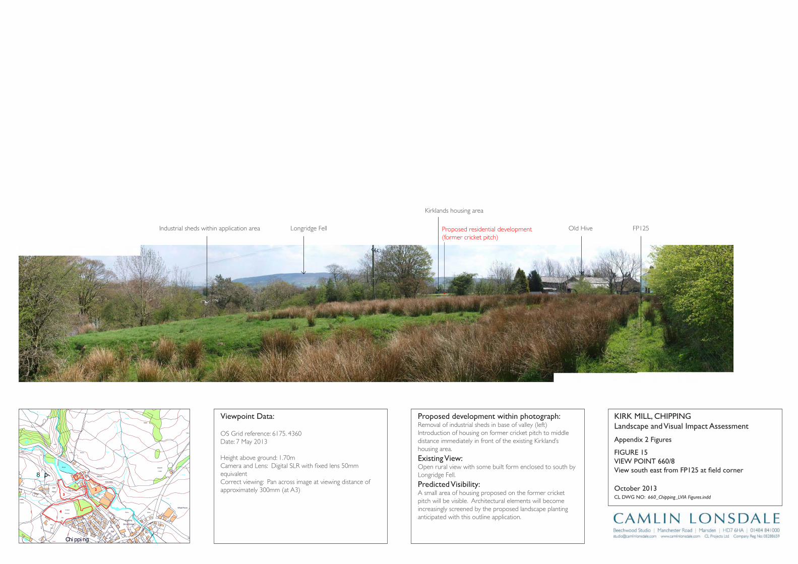
Track
Wharf Farm
Chipping
Brook Bridge
Grove Square
Meadow
Hey
Hawthorns
Track
Issues
Black Hall
Croft
Path
Iss
Isaacs
House
Tk
Pat
h
Drain
Drain
Track
Farm
Works
Sinks
Blackhall
CG
Dairy Barn
Dairy Farm
Drain
Dr ain
Drain
Drain
Drain
Drain
Drain
FB
FB
FB
FB
FB
Fairhaven
Farm
Ferry Butts
Green
Grove
Harling House
Highfield
Hill Clough
Holton Hill
House
Isaac's Farm
Issues
Issues
Issues
Issues
Issues
Issues
Issues
Issues
Issues
Issues
Issues
Issues
Issues
Issues
Issues
Issues
Issues
Issues
Issues
Issues
Issues
Issues
CT
DLEI
FK
OO
RB
DL
EIF
KRI
K
SD
NALK
RIK
CT
SYDEEWT
DLEI
FK
RIK
SD
NALK
OO
RB
KIRK
LAND
S
TE
ERTS
YD
NIW
EN
AL
SWINGLEHURST
DLEIFKRIK
WO
RB
NLI
KTL
AM
TEE
RTS
T
OBLAT
WODAEM
BROAD
RAIKE
CHURCH
LANE
GREEN
EN
ALESUOHHSIF
LANE
HOUSE
KCAL
B
LANE
MOSS
DAOR
GNATSRAG
Issues
Issues
Issues
Issues
Issues
Issues
Issues
Issues
Issues
Issues
Issues
Issues
Issues
Kirk Mills
Lane Ends
Leag
ram
Bro
ok
Lingey Hill
Mill
Moss Side
Nan
Wolfen
Weirs
Weir
Weir
Weir
Weir
Weir
Top O'Saunders
Three
Startifants
Spr
Spr
Spr
Spr
Spr
Spr
Sluice
SlackSinks
Sinks
Sinks
Sinks
Sinks
Sinks
Sinks
Sinks
Sinks
Showground
Pat
h Path
Path
Path
Path
Path
Path
Path
Path
Path
Pat
h
Track
Track
Track
163m
163m
176m
162m
156m
169m
98m
97m
Austin
101m
96m
96m
102m
113m
97m
147m
134m
109m
169m
131m
139m
117m
107m
190m
185m
175m
170m
170m
165m
160m
195 m
155m
150m
145m 14 0m
1 35 m
130m
175m
165m
160m
145m
120m
110m
100m
140m
135m
125m
170m
160m
150m
140m
135m
130m
125m
100m
100m
105m
110m
115m
120m
100m
Holme
Paths
Fish
House
IssPath
Dob
son'
sBr
ook
Path
Path
Path
The Grove
King's Wood
Iss
Nan King's
Farm
Path
Path
Springs
House
Path
GP
After
Lee
Pat h
Sta
Pol
Cricket
Ground
Pav
Old
Hive
Sch
Sch
PW
PO
PW
Vic
The
Field
Iss
Path
Path
Path
Pat h
Abbot
Barn
Clark
House
Path
C h i p p i n gPW
Works
Pat
h
War
Meml
Iss
Iss
Leagram
Lodge
Path
Chi
ppin
gBr
ook
Path
Path
Iss
Brickhouse
Cottage
Issues
Leagram
Hall
IssCottage
Throstle Nest
GP
Cuthbert
Hill
Path
Radcliffe
Hall
Daub
Hall
Little Daub
Hall
The
Croft
Meridor
GP
Sewage
Works
Brookside
High
Head
Goose Lane
Cottages
New
Barnfield
Radcliffe Cottage
High Head
Wood
Valve House
Hotel
Moss Lane
House
125m
Path
Iss
Iss
HallPlaying
Fields
8
Appendix 2 Figures
KirK Mill, Chippinglandscape and Visual impact Assessment
Cl DWg nO: 660_Chipping_LVIA Figures.indd
October 2013
proposed development within photograph:Removal of industrial sheds in base of valley (left) Introduction of housing on former cricket pitch to middle distance immediately in front of the existing Kirkland’s housing area.
Existing View:Open rural view with some built form enclosed to south by Longridge Fell.
predicted Visibility: A small area of housing proposed on the former cricket pitch will be visible. Architectural elements will become increasingly screened by the proposed landscape planting anticipated with this outline application.
Viewpoint Data:
OS Grid reference: 6175. 4360Date: 7 May 2013
Height above ground: 1.70mCamera and Lens: Digital SLR with fixed lens 50mm equivalentCorrect viewing: Pan across image at viewing distance of approximately 300mm (at A3)
View south east from FP125 at field corner
FigUrE 15ViEW pOinT 660/8
2
1
3
4
Proposed residential development(former cricket pitch)
Industrial sheds within application area Longridge Fell
Kirklands housing area
Old Hive FP125
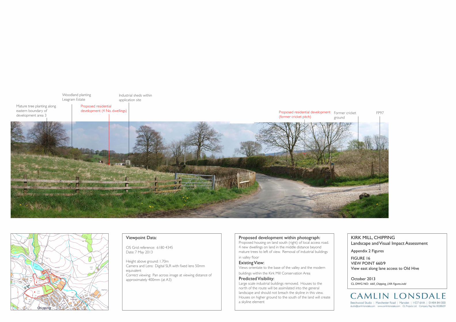
Track
Wharf Farm
Chipping
Brook Bridge
Grove Square
Meadow
Hey
Hawthorns
Track
Issues
Black Hall
Croft
Path
Iss
Isaacs
House
Tk
Pat
h
Drain
Drain
Track
Farm
Works
Sinks
Blackhall
CG
Dairy Barn
Dairy Farm
Drain
Dr ain
Drain
Drain
Drain
Drain
Drain
FB
FB
FB
FB
FB
Fairhaven
Farm
Ferry Butts
Green
Grove
Harling House
Highfield
Hill Clough
Holton Hill
House
Isaac's Farm
Issues
Issues
Issues
Issues
Issues
Issues
Issues
Issues
Issues
Issues
Issues
Issues
Issues
Issues
Issues
Issues
Issues
Issues
Issues
Issues
Issues
Issues
CT
DLEI
FK
OO
RB
DL
EIF
KRI
K
SD
NALK
RIK
CT
SYDEEWT
DLEI
FK
RIK
SD
NALK
OO
RB
KIRK
LAND
S
TE
ERTS
YD
NIW
EN
AL
SWINGLEHURST
DLEIFKRIK
WO
RB
NLI
KTL
AM
TEE
RTS
T
OBLAT
WODAEM
BROAD
RAIKE
CHURCH
LANE
GREEN
EN
ALESUOHHSIF
LANE
HOUSE
KCAL
B
LANE
MOSS
DAOR
GNATSRAG
Issues
Issues
Issues
Issues
Issues
Issues
Issues
Issues
Issues
Issues
Issues
Issues
Issues
Kirk Mills
Lane Ends
Leag
ram
Bro
ok
Lingey Hill
Mill
Moss Side
Nan
Wolfen
Weirs
Weir
Weir
Weir
Weir
Weir
Top O'Saunders
Three
Startifants
Spr
Spr
Spr
Spr
Spr
Spr
Sluice
SlackSinks
Sinks
Sinks
Sinks
Sinks
Sinks
Sinks
Sinks
Sinks
Showground
Pat
h Path
Path
Path
Path
Path
Path
Path
Path
Path
Pat
h
Track
Track
Track
163m
163m
176m
162m
156m
169m
98m
97m
Austin
101m
96m
96m
102m
113m
97m
147m
134m
109m
169m
131m
139m
117m
107m
190m
185m
175m
170m
170m
165m
160m
195 m
155m
150m
145m 14 0m
1 35 m
130m
175m
165m
160m
145m
120m
110m
100m
140m
135m
125m
170m
160m
150m
140m
135m
130m
125m
100m
100m
105m
110m
115m
120m
100m
Holme
Paths
Fish
House
IssPath
Dob
son'
sBr
ook
Path
Path
Path
The Grove
King's Wood
Iss
Nan King's
Farm
Path
Path
Springs
House
Path
GP
After
Lee
Pat h
Sta
Pol
Cricket
Ground
Pav
Old
Hive
Sch
Sch
PW
PO
PW
Vic
The
Field
Iss
Path
Path
Path
Pat h
Abbot
Barn
Clark
House
Path
C h i p p i n gPW
Works
Pat
h
War
Meml
Iss
Iss
Leagram
Lodge
Path
Chi
ppin
gBr
ook
Path
Path
Iss
Brickhouse
Cottage
Issues
Leagram
Hall
IssCottage
Throstle Nest
GP
Cuthbert
Hill
Path
Radcliffe
Hall
Daub
Hall
Little Daub
Hall
The
Croft
Meridor
GP
Sewage
Works
Brookside
High
Head
Goose Lane
Cottages
New
Barnfield
Radcliffe Cottage
High Head
Wood
Valve House
Hotel
Moss Lane
House
125m
Path
Iss
Iss
HallPlaying
Fields
9
Appendix 2 Figures
KirK Mill, Chippinglandscape and Visual impact Assessment
Cl DWg nO: 660_Chipping_LVIA Figures.indd
October 2013
proposed development within photograph:Proposed housing on land south (right) of local access road. 4 new dwellings on land in the middle distance beyond mature trees to left of view. Removal of industrial buildings
in valley floor
Existing View:Views orientate to the base of the valley and the modern
buildings within the Kirk Mill Conservation Area
predicted Visibility: Large scale industrial buildings removed. Houses to the north of the route will be assimilated into the general landscape and should not breach the skyline in this view. Houses on higher ground to the south of the land will create a skyline element
Viewpoint Data:
OS Grid reference: 6180 4345Date: 7 May 2013
Height above ground: 1.70mCamera and Lens: Digital SLR with fixed lens 50mm equivalentCorrect viewing: Pan across image at viewing distance of approximately 400mm (at A3)
View east along lane access to Old hive
FigUrE 16ViEW pOinT 660/9
2
1
3
4
Proposed residential development (4 No. dwellings) Proposed residential development
(former cricket pitch)
Woodland plantingLeagram Estate
Mature tree planting along eastern boundary of development area 3
Industrial sheds within application site
Former cricket ground
FP97

Track
Wharf Farm
Chipping
Brook Bridge
Grove Square
Meadow
Hey
Hawthorns
Track
Issues
Black Hall
Croft
Path
Iss
Isaacs
House
Tk
Pat
h
Drain
Drain
Track
Farm
Works
Sinks
Blackhall
CG
Dairy Barn
Dairy Farm
Drain
Dr ain
Drain
Drain
Drain
Drain
Drain
FB
FB
FB
FB
FB
Fairhaven
Farm
Ferry Butts
Green
Grove
Harling House
Highfield
Hill Clough
Holton Hill
House
Isaac's Farm
Issues
Issues
Issues
Issues
Issues
Issues
Issues
Issues
Issues
Issues
Issues
Issues
Issues
Issues
Issues
Issues
Issues
Issues
Issues
Issues
Issues
Issues
CT
DLEI
FK
OO
RB
DL
EIF
KRI
K
SD
NALK
RIK
CT
SYDEEWT
DLEI
FK
RIK
SD
NALK
OO
RB
KIRK
LAND
S
TE
ERTS
YD
NIW
EN
AL
SWINGLEHURST
DLEIFKRIK
WO
RB
NLI
KTL
AM
TEE
RTS
T
OBLAT
WODAEM
BROAD
RAIKE
CHURCH
LANE
GREEN
EN
ALESUOHHSIF
LANE
HOUSE
KCAL
B
LANE
MOSS
DAOR
GNATSRAG
Issues
Issues
Issues
Issues
Issues
Issues
Issues
Issues
Issues
Issues
Issues
Issues
Issues
Kirk Mills
Lane Ends
Leag
ram
Bro
ok
Lingey Hill
Mill
Moss Side
Nan
Wolfen
Weirs
Weir
Weir
Weir
Weir
Weir
Top O'Saunders
Three
Startifants
Spr
Spr
Spr
Spr
Spr
Spr
Sluice
SlackSinks
Sinks
Sinks
Sinks
Sinks
Sinks
Sinks
Sinks
Sinks
Showground
Pat
h Path
Path
Path
Path
Path
Path
Path
Path
Path
Pat
h
Track
Track
Track
163m
163m
176m
162m
156m
169m
98m
97m
Austin
101m
96m
96m
102m
113m
97m
147m
134m
109m
169m
131m
139m
117m
107m
190m
185m
175m
170m
170m
165m
160m
195 m
155m
150m
145m 14 0m
1 35 m
130m
175m
165m
160m
145m
120m
110m
100m
140m
135m
125m
170m
160m
150m
140m
135m
130m
125m
100m
100m
105m
110m
115m
120m
100m
Holme
Paths
Fish
House
IssPath
Dob
son'
sBr
ook
Path
Path
Path
The Grove
King's Wood
Iss
Nan King's
Farm
Path
Path
Springs
House
Path
GP
After
Lee
Pat h
Sta
Pol
Cricket
Ground
Pav
Old
Hive
Sch
Sch
PW
PO
PW
Vic
The
Field
Iss
Path
Path
Path
Pat h
Abbot
Barn
Clark
House
Path
C h i p p i n gPW
Works
Pat
h
War
Meml
Iss
Iss
Leagram
Lodge
Path
Chi
ppin
gBr
ook
Path
Path
Iss
Brickhouse
Cottage
Issues
Leagram
Hall
IssCottage
Throstle Nest
GP
Cuthbert
Hill
Path
Radcliffe
Hall
Daub
Hall
Little Daub
Hall
The
Croft
Meridor
GP
Sewage
Works
Brookside
High
Head
Goose Lane
Cottages
New
Barnfield
Radcliffe Cottage
High Head
Wood
Valve House
Hotel
Moss Lane
House
125m
Path
Iss
Iss
HallPlaying
Fields
10
Appendix 2 Figures
KirK Mill, Chippinglandscape and Visual impact Assessment
Cl DWg nO: 660_Chipping_LVIA Figures.indd
October 2013
proposed development within photograph:Proposed housing in foreground to middle distance to right of view. 4 dwellings in the middle distance (beyond remnant hedge) to centre of view.
Existing View:Attractive edge of village view, influenced by existing industrial development in the valley, with long distance views to the surrounding fells.
predicted Visibility: Residential development will extend built form to the foreground of the view, restricting long distance views to Longridge Fell from this location.Proposed planting would reduce the visual presence of architectural elements as it becomes established.
Viewpoint Data:
OS Grid reference: 6175 4340Date: 7 May 2013
Height above ground: 1.70mCamera and Lens: Digital SLR with fixed lens 50mm equivalentCorrect viewing: Pan across image at viewing distance of approximately 300mm (at A3)
View northeast from Fp97
FigUrE 17ViEW pOinT 660/10
2
1
3
4
Proposed residential development(former cricket ground)
Proposed residential development(4 No. dwellings)
Old HiveWoodland plantingLeagram Estate FP97 Former cricket ground Kirklands
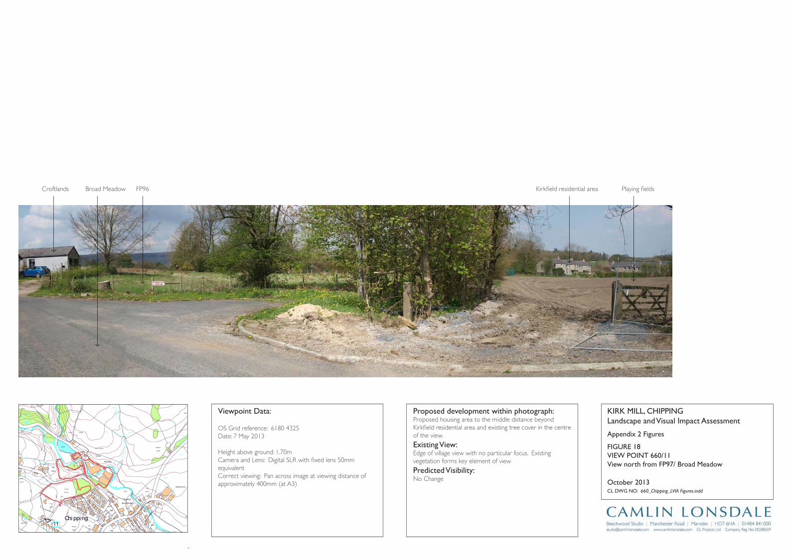
Track
Wharf Farm
Chipping
Brook Bridge
Grove Square
Meadow
Hey
Hawthorns
Track
Issues
Black Hall
Croft
Path
Iss
Isaacs
House
Tk
Pat
h
Drain
Drain
Track
Farm
Works
Sinks
Blackhall
CG
Dairy Barn
Dairy Farm
Drain
Dr ain
Drain
Drain
Drain
Drain
Drain
FB
FB
FB
FB
FB
Fairhaven
Farm
Ferry Butts
Green
Grove
Harling House
Highfield
Hill Clough
Holton Hill
House
Isaac's Farm
Issues
Issues
Issues
Issues
Issues
Issues
Issues
Issues
Issues
Issues
Issues
Issues
Issues
Issues
Issues
Issues
Issues
Issues
Issues
Issues
Issues
Issues
CT
DLEI
FK
OO
RB
DL
EIF
KRI
K
SD
NALK
RIK
CT
SYDEEWT
DLEI
FK
RIK
SD
NALK
OO
RB
KIRK
LAND
S
TE
ERTS
YD
NIW
EN
AL
SWINGLEHURST
DLEIFKRIK
WO
RB
NLI
KTL
AM
TEE
RTS
T
OBLAT
WODAEM
BROAD
RAIKE
CHURCH
LANE
GREEN
EN
ALESUOHHSIF
LANE
HOUSE
KCAL
B
LANE
MOSS
DAOR
GNATSRAG
Issues
Issues
Issues
Issues
Issues
Issues
Issues
Issues
Issues
Issues
Issues
Issues
Issues
Kirk Mills
Lane Ends
Leag
ram
Bro
ok
Lingey Hill
Mill
Moss Side
Nan
Wolfen
Weirs
Weir
Weir
Weir
Weir
Weir
Top O'Saunders
Three
Startifants
Spr
Spr
Spr
Spr
Spr
Spr
Sluice
SlackSinks
Sinks
Sinks
Sinks
Sinks
Sinks
Sinks
Sinks
Sinks
Showground
Pat
h Path
Path
Path
Path
Path
Path
Path
Path
Path
Pat
h
Track
Track
Track
163m
163m
176m
162m
156m
169m
98m
97m
Austin
101m
96m
96m
102m
113m
97m
147m
134m
109m
169m
131m
139m
117m
107m
190m
185m
175m
170m
170m
165m
160m
195 m
155m
150m
145m 14 0m
1 35 m
130m
175m
165m
160m
145m
120m
110m
100m
140m
135m
125m
170m
160m
150m
140m
135m
130m
125m
100m
100m
105m
110m
115m
120m
100m
Holme
Paths
Fish
House
IssPath
Dob
son'
sBr
ook
Path
Path
Path
The Grove
King's Wood
Iss
Nan King's
Farm
Path
Path
Springs
House
Path
GP
After
Lee
Pat h
Sta
Pol
Cricket
Ground
Pav
Old
Hive
Sch
Sch
PW
PO
PW
Vic
The
Field
Iss
Path
Path
Path
Pat h
Abbot
Barn
Clark
House
Path
C h i p p i n gPW
Works
Pat
h
War
Meml
Iss
Iss
Leagram
Lodge
Path
Chi
ppin
gBr
ook
Path
Path
Iss
Brickhouse
Cottage
Issues
Leagram
Hall
IssCottage
Throstle Nest
GP
Cuthbert
Hill
Path
Radcliffe
Hall
Daub
Hall
Little Daub
Hall
The
Croft
Meridor
GP
Sewage
Works
Brookside
High
Head
Goose Lane
Cottages
New
Barnfield
Radcliffe Cottage
High Head
Wood
Valve House
Hotel
Moss Lane
House
125m
Path
Iss
Iss
HallPlaying
Fields
11
Appendix 2 Figures
KirK Mill, Chippinglandscape and Visual impact Assessment
Cl DWg nO: 660_Chipping_LVIA Figures.indd
October 2013
proposed development within photograph:Proposed housing area to the middle distance beyond Kirkfield residential area and existing tree cover in the centre of the view.
Existing View:Edge of village view with no particular focus. Existing vegetation forms key element of view
predicted Visibility: No Change
Viewpoint Data:
OS Grid reference: 6180 4325Date: 7 May 2013
Height above ground: 1.70mCamera and Lens: Digital SLR with fixed lens 50mm equivalentCorrect viewing: Pan across image at viewing distance of approximately 400mm (at A3)
View north from Fp97/ Broad Meadow
FigUrE 18ViEW pOinT 660/11
4
Croftlands Broad Meadow Kirkfield residential area Playing fieldsFP96

Track
Wharf Farm
Chipping
Brook Bridge
Grove Square
Meadow
Hey
Hawthorns
Track
Issues
Black Hall
Croft
Path
Iss
Isaacs
House
Tk
Pat
h
Drain
Drain
Track
Farm
Works
Sinks
Blackhall
CG
Dairy Barn
Dairy Farm
Drain
Dr ain
Drain
Drain
Drain
Drain
Drain
FB
FB
FB
FB
FB
Fairhaven
Farm
Ferry Butts
Green
Grove
Harling House
Highfield
Hill Clough
Holton Hill
House
Isaac's Farm
Issues
Issues
Issues
Issues
Issues
Issues
Issues
Issues
Issues
Issues
Issues
Issues
Issues
Issues
Issues
Issues
Issues
Issues
Issues
Issues
Issues
Issues
CT
DLEI
FK
OO
RB
DL
EIF
KRI
K
SD
NALK
RIK
CT
SYDEEWT
DLEI
FK
RIK
SD
NALK
OO
RB
KIRK
LAND
S
TE
ERTS
YD
NIW
EN
AL
SWINGLEHURST
DLEIFKRIK
WO
RB
NLI
KTL
AM
TEE
RTS
T
OBLAT
WODAEM
BROAD
RAIKE
CHURCH
LANE
GREEN
EN
ALESUOHHSIF
LANE
HOUSE
KCAL
B
LANE
MOSS
DAOR
GNATSRAG
Issues
Issues
Issues
Issues
Issues
Issues
Issues
Issues
Issues
Issues
Issues
Issues
Issues
Kirk Mills
Lane Ends
Leag
ram
Bro
ok
Lingey Hill
Mill
Moss Side
Nan
Wolfen
Weirs
Weir
Weir
Weir
Weir
Weir
Top O'Saunders
Three
Startifants
Spr
Spr
Spr
Spr
Spr
Spr
Sluice
SlackSinks
Sinks
Sinks
Sinks
Sinks
Sinks
Sinks
Sinks
Sinks
Showground
Pat
h Path
Path
Path
Path
Path
Path
Path
Path
Path
Pat
h
Track
Track
Track
163m
163m
176m
162m
156m
169m
98m
97m
Austin
101m
96m
96m
102m
113m
97m
147m
134m
109m
169m
131m
139m
117m
107m
190m
185m
175m
170m
170m
165m
160m
195 m
155m
150m
145m 14 0m
1 35 m
130m
175m
165m
160m
145m
120m
110m
100m
140m
135m
125m
170m
160m
150m
140m
135m
130m
125m
100m
100m
105m
110m
115m
120m
100m
Holme
Paths
Fish
House
IssPath
Dob
son'
sBr
ook
Path
Path
Path
The Grove
King's Wood
Iss
Nan King's
Farm
Path
Path
Springs
House
Path
GP
After
Lee
Pat h
Sta
Pol
Cricket
Ground
Pav
Old
Hive
Sch
Sch
PW
PO
PW
Vic
The
Field
Iss
Path
Path
Path
Pat h
Abbot
Barn
Clark
House
Path
C h i p p i n gPW
Works
Pat
h
War
Meml
Iss
Iss
Leagram
Lodge
Path
Chi
ppin
gBr
ook
Path
Path
Iss
Brickhouse
Cottage
Issues
Leagram
Hall
IssCottage
Throstle Nest
GP
Cuthbert
Hill
Path
Radcliffe
Hall
Daub
Hall
Little Daub
Hall
The
Croft
Meridor
GP
Sewage
Works
Brookside
High
Head
Goose Lane
Cottages
New
Barnfield
Radcliffe Cottage
High Head
Wood
Valve House
Hotel
Moss Lane
House
125m
Path
Iss
Iss
HallPlaying
Fields
12
Appendix 2 Figures
KirK Mill, Chippinglandscape and Visual impact Assessment
Cl DWg nO: 660_Chipping_LVIA Figures.indd
October 2013
proposed development within photograph:Residential development introduced to the left of the view behind the existing overgrown hedge.
Existing View:View along rear access route to existing housing, which currently experiences filtered views into the former cricket pitch from upper storey windows.
predicted Visibility: Garden boundaries and housing elements are introduced to the left of the view potential foreshortening of views from existing upper storey windows in housing to the right of the view. Existing vegetation, supported by anticipated landscape proposals would reduce the visual presence of the architectural elements as it becomes established.
Viewpoint Data:
OS Grid reference: 6190 4365Date: 7 May 2013
Height above ground: 1.70mCamera and Lens: Digital SLR with fixed lens 50mm equivalentCorrect viewing: Pan across image at viewing distance of approximately 500mm (at A3)
View east along rear pedestrian access route to properties on northern edge of Kirkfield
FigUrE 19ViEW pOinT 660/12
2
1
3
4
Proposed residential development Site boundary (former cricket ground) Kirklands (Properties fronting Church Raike) Kirkfields
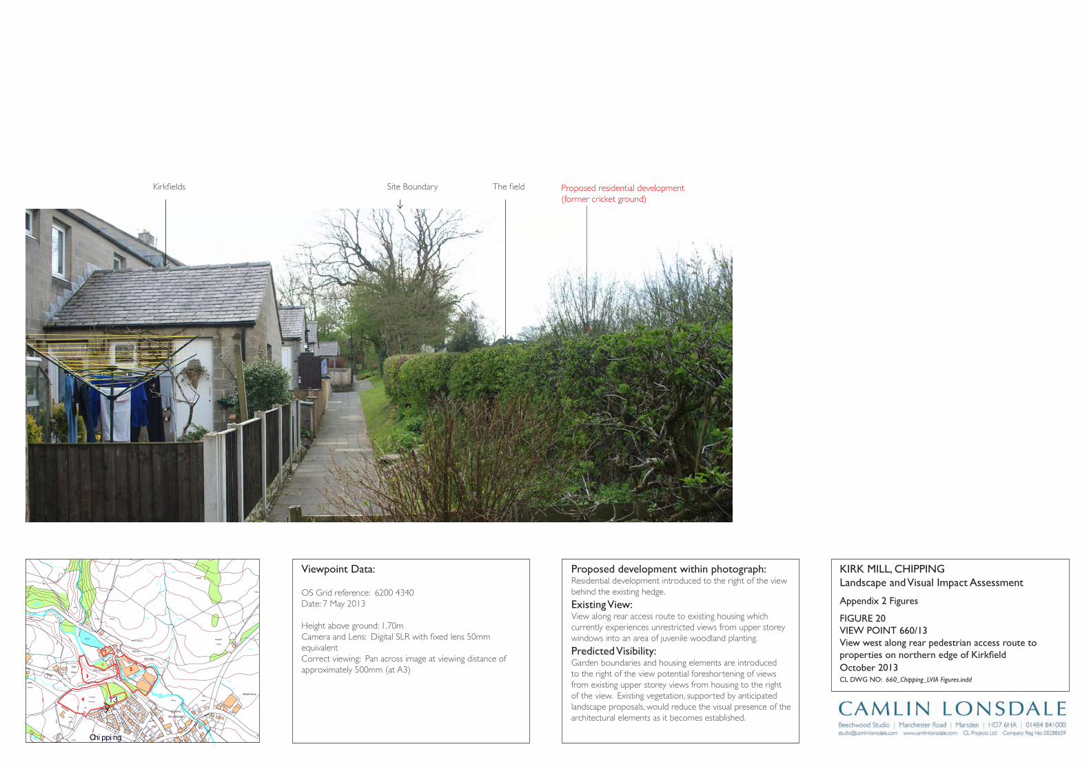
Track
Wharf Farm
Chipping
Brook Bridge
Grove Square
Meadow
Hey
Hawthorns
Track
Issues
Black Hall
Croft
Path
Iss
Isaacs
House
Tk
Pat
h
Drain
Drain
Track
Farm
Works
Sinks
Blackhall
CG
Dairy Barn
Dairy Farm
Drain
Dr ain
Drain
Drain
Drain
Drain
Drain
FB
FB
FB
FB
FB
Fairhaven
Farm
Ferry Butts
Green
Grove
Harling House
Highfield
Hill Clough
Holton Hill
House
Isaac's Farm
Issues
Issues
Issues
Issues
Issues
Issues
Issues
Issues
Issues
Issues
Issues
Issues
Issues
Issues
Issues
Issues
Issues
Issues
Issues
Issues
Issues
Issues
CT
DLEI
FK
OO
RB
DL
EIF
KRI
K
SD
NALK
RIK
CT
SYDEEWT
DLEI
FK
RIK
SD
NALK
OO
RB
KIRK
LAND
S
TE
ERTS
YD
NIW
EN
AL
SWINGLEHURST
DLEIFKRIK
WO
RB
NLI
KTL
AM
TEE
RTS
T
OBLAT
WODAEM
BROAD
RAIKE
CHURCH
LANE
GREEN
EN
ALESUOHHSIF
LANE
HOUSE
KCAL
B
LANE
MOSS
DAOR
GNATSRAG
Issues
Issues
Issues
Issues
Issues
Issues
Issues
Issues
Issues
Issues
Issues
Issues
Issues
Kirk Mills
Lane Ends
Leag
ram
Bro
ok
Lingey Hill
Mill
Moss Side
Nan
Wolfen
Weirs
Weir
Weir
Weir
Weir
Weir
Top O'Saunders
Three
Startifants
Spr
Spr
Spr
Spr
Spr
Spr
Sluice
SlackSinks
Sinks
Sinks
Sinks
Sinks
Sinks
Sinks
Sinks
Sinks
Showground
Pat
h Path
Path
Path
Path
Path
Path
Path
Path
Path
Pat
h
Track
Track
Track
163m
163m
176m
162m
156m
169m
98m
97m
Austin
101m
96m
96m
102m
113m
97m
147m
134m
109m
169m
131m
139m
117m
107m
190m
185m
175m
170m
170m
165m
160m
195 m
155m
150m
145m 14 0m
1 35 m
130m
175m
165m
160m
145m
120m
110m
100m
140m
135m
125m
170m
160m
150m
140m
135m
130m
125m
100m
100m
105m
110m
115m
120m
100m
Holme
Paths
Fish
House
IssPath
Dob
son'
sBr
ook
Path
Path
Path
The Grove
King's Wood
Iss
Nan King's
Farm
Path
Path
Springs
House
Path
GP
After
Lee
Pat h
Sta
Pol
Cricket
Ground
Pav
Old
Hive
Sch
Sch
PW
PO
PW
Vic
The
Field
Iss
Path
Path
Path
Pat h
Abbot
Barn
Clark
House
Path
C h i p p i n gPW
Works
Pat
h
War
Meml
Iss
Iss
Leagram
Lodge
Path
Chi
ppin
gBr
ook
Path
Path
Iss
Brickhouse
Cottage
Issues
Leagram
Hall
IssCottage
Throstle Nest
GP
Cuthbert
Hill
Path
Radcliffe
Hall
Daub
Hall
Little Daub
Hall
The
Croft
Meridor
GP
Sewage
Works
Brookside
High
Head
Goose Lane
Cottages
New
Barnfield
Radcliffe Cottage
High Head
Wood
Valve House
Hotel
Moss Lane
House
125m
Path
Iss
Iss
HallPlaying
Fields
13
Appendix 2 Figures
KirK Mill, Chippinglandscape and Visual impact Assessment
Cl DWg nO: 660_Chipping_LVIA Figures.indd
October 2013
proposed development within photograph:Residential development introduced to the right of the view behind the existing hedge.
Existing View:View along rear access route to existing housing which currently experiences unrestricted views from upper storey windows into an area of juvenile woodland planting.
predicted Visibility: Garden boundaries and housing elements are introduced to the right of the view potential foreshortening of views from existing upper storey views from housing to the right of the view. Existing vegetation, supported by anticipated landscape proposals, would reduce the visual presence of the architectural elements as it becomes established.
Viewpoint Data:
OS Grid reference: 6200 4340Date: 7 May 2013
Height above ground: 1.70mCamera and Lens: Digital SLR with fixed lens 50mm equivalentCorrect viewing: Pan across image at viewing distance of approximately 500mm (at A3)
View west along rear pedestrian access route to properties on northern edge of Kirkfield
FigUrE 20ViEW pOinT 660/13
2
1
3
4
Proposed residential development(former cricket ground)
Kirkfields The fieldSite Boundary
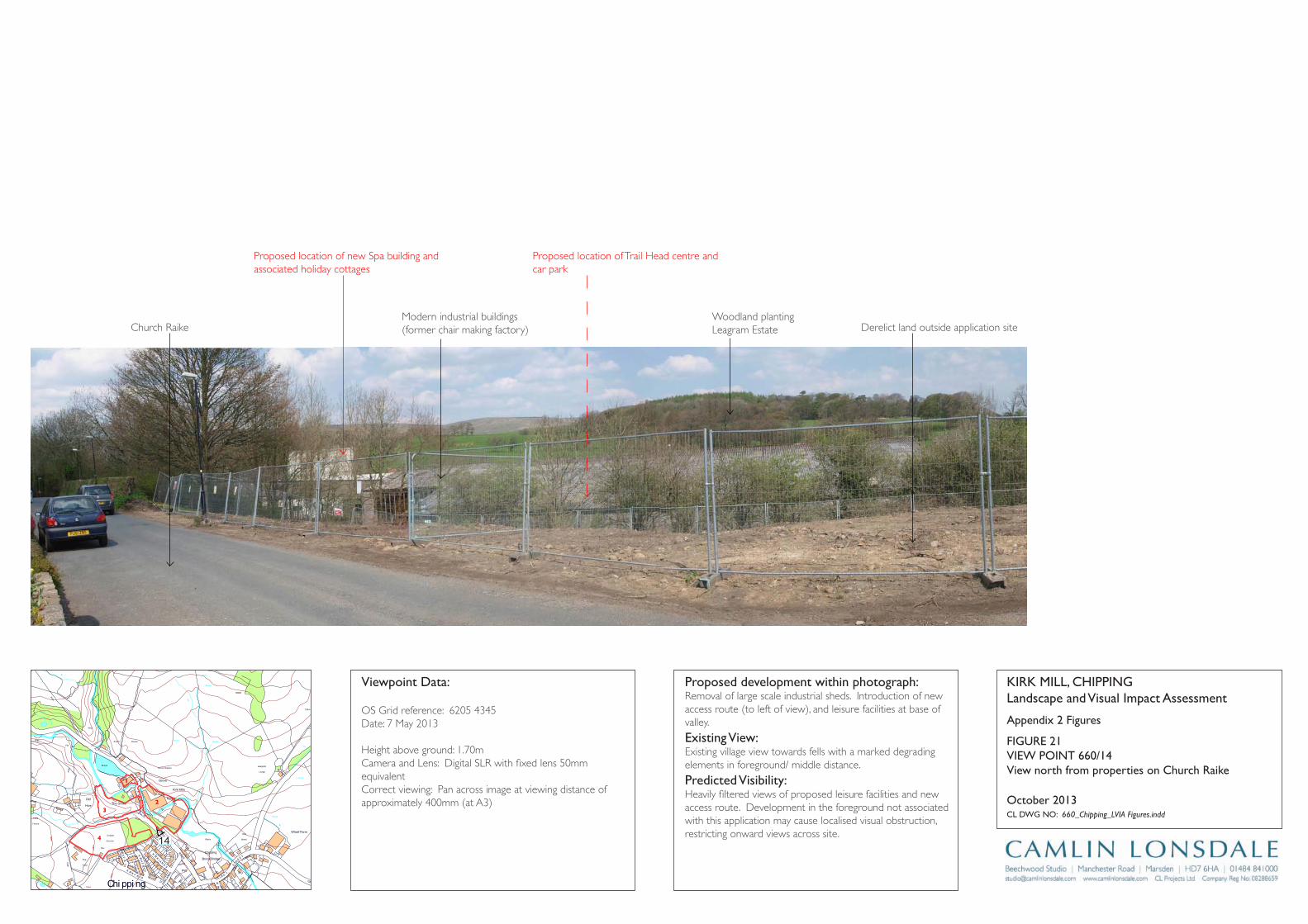
Track
Wharf Farm
Chipping
Brook Bridge
Grove Square
Meadow
Hey
Hawthorns
Track
Issues
Black Hall
Croft
Path
Iss
Isaacs
House
Tk
Pat
h
Drain
Drain
Track
Farm
Works
Sinks
Blackhall
CG
Dairy Barn
Dairy Farm
Drain
Dr ain
Drain
Drain
Drain
Drain
Drain
FB
FB
FB
FB
FB
Fairhaven
Farm
Ferry Butts
Green
Grove
Harling House
Highfield
Hill Clough
Holton Hill
House
Isaac's Farm
Issues
Issues
Issues
Issues
Issues
Issues
Issues
Issues
Issues
Issues
Issues
Issues
Issues
Issues
Issues
Issues
Issues
Issues
Issues
Issues
Issues
Issues
CT
DLEI
FK
OO
RB
DL
EIF
KRI
K
SD
NALK
RIK
CT
SYDEEWT
DLEI
FK
RIK
SD
NALK
OO
RB
KIRK
LAND
S
TE
ERTS
YD
NIW
EN
AL
SWINGLEHURST
DLEIFKRIK
WO
RB
NLI
KTL
AM
TEE
RTS
T
OBLAT
WODAEM
BROAD
RAIKE
CHURCH
LANE
GREEN
EN
ALESUOHHSIF
LANE
HOUSE
KCAL
B
LANE
MOSS
DAOR
GNATSRAG
Issues
Issues
Issues
Issues
Issues
Issues
Issues
Issues
Issues
Issues
Issues
Issues
Issues
Kirk Mills
Lane Ends
Leag
ram
Bro
ok
Lingey Hill
Mill
Moss Side
Nan
Wolfen
Weirs
Weir
Weir
Weir
Weir
Weir
Top O'Saunders
Three
Startifants
Spr
Spr
Spr
Spr
Spr
Spr
Sluice
SlackSinks
Sinks
Sinks
Sinks
Sinks
Sinks
Sinks
Sinks
Sinks
Showground
Pat
h Path
Path
Path
Path
Path
Path
Path
Path
Path
Pat
h
Track
Track
Track
163m
163m
176m
162m
156m
169m
98m
97m
Austin
101m
96m
96m
102m
113m
97m
147m
134m
109m
169m
131m
139m
117m
107m
190m
185m
175m
170m
170m
165m
160m
195 m
155m
150m
145m 14 0m
1 35 m
130m
175m
165m
160m
145m
120m
110m
100m
140m
135m
125m
170m
160m
150m
140m
135m
130m
125m
100m
100m
105m
110m
115m
120m
100m
Holme
Paths
Fish
House
IssPath
Dob
son'
sBr
ook
Path
Path
Path
The Grove
King's Wood
Iss
Nan King's
Farm
Path
Path
Springs
House
Path
GP
After
Lee
Pat h
Sta
Pol
Cricket
Ground
Pav
Old
Hive
Sch
Sch
PW
PO
PW
Vic
The
Field
Iss
Path
Path
Path
Pat h
Abbot
Barn
Clark
House
Path
C h i p p i n gPW
Works
Pat
h
War
Meml
Iss
Iss
Leagram
Lodge
Path
Chi
ppin
gBr
ook
Path
Path
Iss
Brickhouse
Cottage
Issues
Leagram
Hall
IssCottage
Throstle Nest
GP
Cuthbert
Hill
Path
Radcliffe
Hall
Daub
Hall
Little Daub
Hall
The
Croft
Meridor
GP
Sewage
Works
Brookside
High
Head
Goose Lane
Cottages
New
Barnfield
Radcliffe Cottage
High Head
Wood
Valve House
Hotel
Moss Lane
House
125m
Path
Iss
Iss
HallPlaying
Fields
14
Appendix 2 Figures
KirK Mill, Chippinglandscape and Visual impact Assessment
Cl DWg nO: 660_Chipping_LVIA Figures.indd
October 2013
proposed development within photograph:Removal of large scale industrial sheds. Introduction of new access route (to left of view), and leisure facilities at base of valley.
Existing View:Existing village view towards fells with a marked degrading elements in foreground/ middle distance.
predicted Visibility: Heavily filtered views of proposed leisure facilities and new access route. Development in the foreground not associated with this application may cause localised visual obstruction, restricting onward views across site.
Viewpoint Data:
OS Grid reference: 6205 4345Date: 7 May 2013
Height above ground: 1.70mCamera and Lens: Digital SLR with fixed lens 50mm equivalentCorrect viewing: Pan across image at viewing distance of approximately 400mm (at A3)
View north from properties on Church raike
FigUrE 21ViEW pOinT 660/14
2
1
3
4
Proposed location of new Spa building and associated holiday cottages
Proposed location of Trail Head centre and car park
Modern industrial buildings (former chair making factory)Church Raike
Woodland plantingLeagram Estate Derelict land outside application site
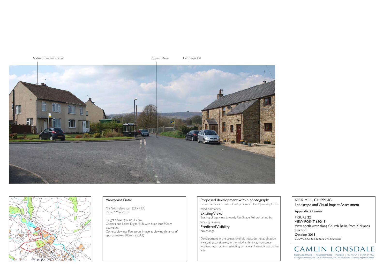
Track
Wharf Farm
Chipping
Brook Bridge
Grove Square
Meadow
Hey
Hawthorns
Track
Issues
Black Hall
Croft
Path
Iss
Isaacs
House
Tk
Pat
h
Drain
Drain
Track
Farm
Works
Sinks
Blackhall
CG
Dairy Barn
Dairy Farm
Drain
Dr ain
Drain
Drain
Drain
Drain
Drain
FB
FB
FB
FB
FB
Fairhaven
Farm
Ferry Butts
Green
Grove
Harling House
Highfield
Hill Clough
Holton Hill
House
Isaac's Farm
Issues
Issues
Issues
Issues
Issues
Issues
Issues
Issues
Issues
Issues
Issues
Issues
Issues
Issues
Issues
Issues
Issues
Issues
Issues
Issues
Issues
Issues
CT
DLEI
FK
OO
RB
DL
EIF
KRI
K
SD
NALK
RIK
CT
SYDEEWT
DLEI
FK
RIK
SD
NALK
OO
RB
KIRK
LAND
S
TE
ERTS
YD
NIW
EN
AL
SWINGLEHURST
DLEIFKRIK
WO
RB
NLI
KTL
AM
TEE
RTS
T
OBLAT
WODAEM
BROAD
RAIKE
CHURCH
LANE
GREEN
EN
ALESUOHHSIF
LANE
HOUSE
KCAL
B
LANE
MOSS
DAOR
GNATSRAG
Issues
Issues
Issues
Issues
Issues
Issues
Issues
Issues
Issues
Issues
Issues
Issues
Issues
Kirk Mills
Lane Ends
Leag
ram
Bro
ok
Lingey Hill
Mill
Moss Side
Nan
Wolfen
Weirs
Weir
Weir
Weir
Weir
Weir
Top O'Saunders
Three
Startifants
Spr
Spr
Spr
Spr
Spr
Spr
Sluice
SlackSinks
Sinks
Sinks
Sinks
Sinks
Sinks
Sinks
Sinks
Sinks
Showground
Pat
h Path
Path
Path
Path
Path
Path
Path
Path
Path
Pat
h
Track
Track
Track
163m
163m
176m
162m
156m
169m
98m
97m
Austin
101m
96m
96m
102m
113m
97m
147m
134m
109m
169m
131m
139m
117m
107m
190m
185m
175m
170m
170m
165m
160m
195 m
155m
150m
145m 14 0m
1 35 m
130m
175m
165m
160m
145m
120m
110m
100m
140m
135m
125m
170m
160m
150m
140m
135m
130m
125m
100m
100m
105m
110m
115m
120m
100m
Holme
Paths
Fish
House
IssPath
Dob
son'
sBr
ook
Path
Path
Path
The Grove
King's Wood
Iss
Nan King's
Farm
Path
Path
Springs
House
Path
GP
After
Lee
Pat h
Sta
Pol
Cricket
Ground
Pav
Old
Hive
Sch
Sch
PW
PO
PW
Vic
The
Field
Iss
Path
Path
Path
Pat h
Abbot
Barn
Clark
House
Path
C h i p p i n gPW
Works
Pat
h
War
Meml
Iss
Iss
Leagram
Lodge
Path
Chi
ppin
gBr
ook
Path
Path
Iss
Brickhouse
Cottage
Issues
Leagram
Hall
IssCottage
Throstle Nest
GP
Cuthbert
Hill
Path
Radcliffe
Hall
Daub
Hall
Little Daub
Hall
The
Croft
Meridor
GP
Sewage
Works
Brookside
High
Head
Goose Lane
Cottages
New
Barnfield
Radcliffe Cottage
High Head
Wood
Valve House
Hotel
Moss Lane
House
125m
Path
Iss
Iss
HallPlaying
Fields
15
Appendix 2 Figures
KirK Mill, Chippinglandscape and Visual impact Assessment
Cl DWg nO: 660_Chipping_LVIA Figures.indd
October 2013
proposed development within photograph:Leisure facilities in base of valley beyond development plot in
middle distance.
Existing View:Existing village view towards Fair Snape Fell contained by
existing housing
predicted Visibility: No change.
Development in the street level plot outside the application area being considered, in the middle distance, may cause localised obstruction restricting on onward views towards the fells.
Viewpoint Data:
OS Grid reference: 6215 4335Date: 7 May 2013
Height above ground: 1.70mCamera and Lens: Digital SLR with fixed lens 50mm equivalentCorrect viewing: Pan across image at viewing distance of approximately 500mm (at A3)
View north west along Church raike from Kirklands Junction
FigUrE 22ViEW pOinT 660/15
2
1
3
4
Kirklands residential area Church Raike Fair Snape Fell
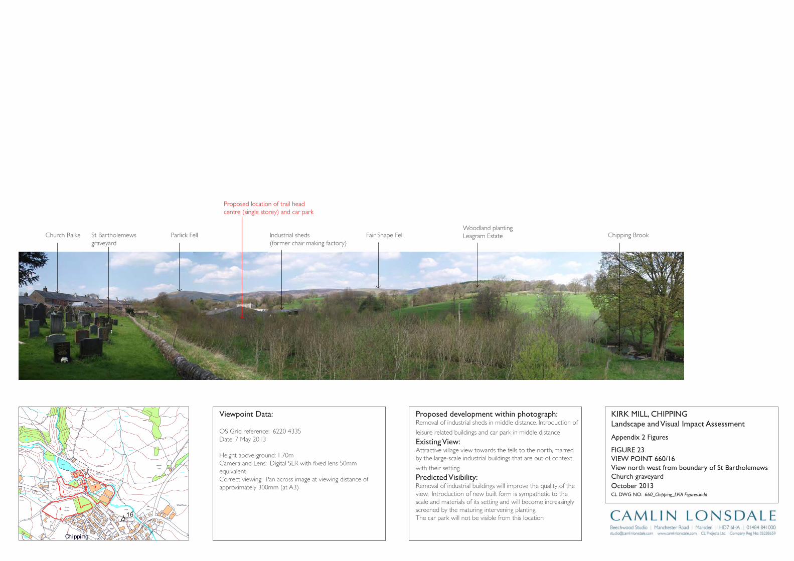
Track
Wharf Farm
Chipping
Brook Bridge
Grove Square
Meadow
Hey
Hawthorns
Track
Issues
Black Hall
Croft
Path
Iss
Isaacs
House
Tk
Pat
h
Drain
Drain
Track
Farm
Works
Sinks
Blackhall
CG
Dairy Barn
Dairy Farm
Drain
Dr ain
Drain
Drain
Drain
Drain
Drain
FB
FB
FB
FB
FB
Fairhaven
Farm
Ferry Butts
Green
Grove
Harling House
Highfield
Hill Clough
Holton Hill
House
Isaac's Farm
Issues
Issues
Issues
Issues
Issues
Issues
Issues
Issues
Issues
Issues
Issues
Issues
Issues
Issues
Issues
Issues
Issues
Issues
Issues
Issues
Issues
Issues
CT
DLEI
FK
OO
RB
DL
EIF
KRI
K
SD
NALK
RIK
CT
SYDEEWT
DLEI
FK
RIK
SD
NALK
OO
RB
KIRK
LAND
S
TE
ERTS
YD
NIW
EN
AL
SWINGLEHURST
DLEIFKRIK
WO
RB
NLI
KTL
AM
TEE
RTS
T
OBLAT
WODAEM
BROAD
RAIKE
CHURCH
LANE
GREEN
EN
ALESUOHHSIF
LANE
HOUSE
KCAL
B
LANE
MOSS
DAOR
GNATSRAG
Issues
Issues
Issues
Issues
Issues
Issues
Issues
Issues
Issues
Issues
Issues
Issues
Issues
Kirk Mills
Lane Ends
Leag
ram
Bro
ok
Lingey Hill
Mill
Moss Side
Nan
Wolfen
Weirs
Weir
Weir
Weir
Weir
Weir
Top O'Saunders
Three
Startifants
Spr
Spr
Spr
Spr
Spr
Spr
Sluice
SlackSinks
Sinks
Sinks
Sinks
Sinks
Sinks
Sinks
Sinks
Sinks
Showground
Pat
h Path
Path
Path
Path
Path
Path
Path
Path
Path
Pat
h
Track
Track
Track
163m
163m
176m
162m
156m
169m
98m
97m
Austin
101m
96m
96m
102m
113m
97m
147m
134m
109m
169m
131m
139m
117m
107m
190m
185m
175m
170m
170m
165m
160m
195 m
155m
150m
145m 14 0m
1 35 m
130m
175m
165m
160m
145m
120m
110m
100m
140m
135m
125m
170m
160m
150m
140m
135m
130m
125m
100m
100m
105m
110m
115m
120m
100m
Holme
Paths
Fish
House
IssPath
Dob
son'
sBr
ook
Path
Path
Path
The Grove
King's Wood
Iss
Nan King's
Farm
Path
Path
Springs
House
Path
GP
After
Lee
Pat h
Sta
Pol
Cricket
Ground
Pav
Old
Hive
Sch
Sch
PW
PO
PW
Vic
The
Field
Iss
Path
Path
Path
Pat h
Abbot
Barn
Clark
House
Path
C h i p p i n gPW
Works
Pat
h
War
Meml
Iss
Iss
Leagram
Lodge
Path
Chi
ppin
gBr
ook
Path
Path
Iss
Brickhouse
Cottage
Issues
Leagram
Hall
IssCottage
Throstle Nest
GP
Cuthbert
Hill
Path
Radcliffe
Hall
Daub
Hall
Little Daub
Hall
The
Croft
Meridor
GP
Sewage
Works
Brookside
High
Head
Goose Lane
Cottages
New
Barnfield
Radcliffe Cottage
High Head
Wood
Valve House
Hotel
Moss Lane
House
125m
Path
Iss
Iss
HallPlaying
Fields
16
Appendix 2 Figures
KirK Mill, Chippinglandscape and Visual impact Assessment
Cl DWg nO: 660_Chipping_LVIA Figures.indd
October 2013
proposed development within photograph:Removal of industrial sheds in middle distance. Introduction of
leisure related buildings and car park in middle distance
Existing View:Attractive village view towards the fells to the north, marred by the large-scale industrial buildings that are out of context
with their setting
predicted Visibility: Removal of industrial buildings will improve the quality of the view. Introduction of new built form is sympathetic to the scale and materials of its setting and will become increasingly screened by the maturing intervening planting.The car park will not be visible from this location
Viewpoint Data:
OS Grid reference: 6220 4335Date: 7 May 2013
Height above ground: 1.70mCamera and Lens: Digital SLR with fixed lens 50mm equivalentCorrect viewing: Pan across image at viewing distance of approximately 300mm (at A3)
View north west from boundary of St Bartholemews Church graveyard
FigUrE 23ViEW pOinT 660/16
2
1
3
4
Proposed location of trail head centre (single storey) and car park
Church Raike St Bartholemews graveyard
Parlick Fell Industrial sheds (former chair making factory)
Fair Snape FellWoodland plantingLeagram Estate Chipping Brook
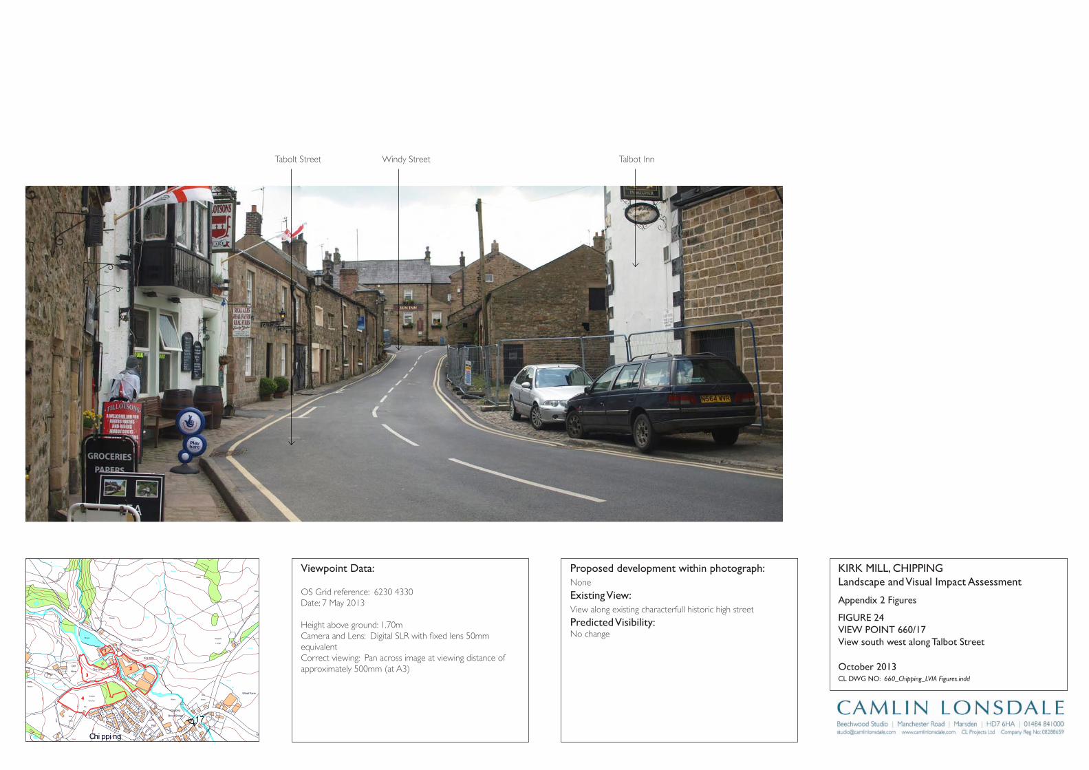
Track
Wharf Farm
Chipping
Brook Bridge
Grove Square
Meadow
Hey
Hawthorns
Track
Issues
Black Hall
Croft
Path
Iss
Isaacs
House
Tk
Pat
h
Drain
Drain
Track
Farm
Works
Sinks
Blackhall
CG
Dairy Barn
Dairy Farm
Drain
Dr ain
Drain
Drain
Drain
Drain
Drain
FB
FB
FB
FB
FB
Fairhaven
Farm
Ferry Butts
Green
Grove
Harling House
Highfield
Hill Clough
Holton Hill
House
Isaac's Farm
Issues
Issues
Issues
Issues
Issues
Issues
Issues
Issues
Issues
Issues
Issues
Issues
Issues
Issues
Issues
Issues
Issues
Issues
Issues
Issues
Issues
Issues
CT
DLEI
FK
OO
RB
DL
EIF
KRI
K
SD
NALK
RIK
CT
SYDEEWT
DLEI
FK
RIK
SD
NALK
OO
RB
KIRK
LAND
S
TE
ERTS
YD
NIW
EN
AL
SWINGLEHURST
DLEIFKRIK
WO
RB
NLI
KTL
AM
TEE
RTS
T
OBLAT
WODAEM
BROAD
RAIKE
CHURCH
LANE
GREEN
EN
ALESUOHHSIF
LANE
HOUSE
KCAL
B
LANE
MOSS
DAOR
GNATSRAG
Issues
Issues
Issues
Issues
Issues
Issues
Issues
Issues
Issues
Issues
Issues
Issues
Issues
Kirk Mills
Lane Ends
Leag
ram
Bro
ok
Lingey Hill
Mill
Moss Side
Nan
Wolfen
Weirs
Weir
Weir
Weir
Weir
Weir
Top O'Saunders
Three
Startifants
Spr
Spr
Spr
Spr
Spr
Spr
Sluice
SlackSinks
Sinks
Sinks
Sinks
Sinks
Sinks
Sinks
Sinks
Sinks
Showground
Pat
h Path
Path
Path
Path
Path
Path
Path
Path
Path
Pat
h
Track
Track
Track
163m
163m
176m
162m
156m
169m
98m
97m
Austin
101m
96m
96m
102m
113m
97m
147m
134m
109m
169m
131m
139m
117m
107m
190m
185m
175m
170m
170m
165m
160m
195 m
155m
150m
145m 14 0m
1 35 m
130m
175m
165m
160m
145m
120m
110m
100m
140m
135m
125m
170m
160m
150m
140m
135m
130m
125m
100m
100m
105m
110m
115m
120m
100m
Holme
Paths
Fish
House
IssPath
Dob
son'
sBr
ook
Path
Path
Path
The Grove
King's Wood
Iss
Nan King's
Farm
Path
Path
Springs
House
Path
GP
After
Lee
Pat h
Sta
Pol
Cricket
Ground
Pav
Old
Hive
Sch
Sch
PW
PO
PW
Vic
The
Field
Iss
Path
Path
Path
Pat h
Abbot
Barn
Clark
House
Path
C h i p p i n gPW
Works
Pat
h
War
Meml
Iss
Iss
Leagram
Lodge
Path
Chi
ppin
gBr
ook
Path
Path
Iss
Brickhouse
Cottage
Issues
Leagram
Hall
IssCottage
Throstle Nest
GP
Cuthbert
Hill
Path
Radcliffe
Hall
Daub
Hall
Little Daub
Hall
The
Croft
Meridor
GP
Sewage
Works
Brookside
High
Head
Goose Lane
Cottages
New
Barnfield
Radcliffe Cottage
High Head
Wood
Valve House
Hotel
Moss Lane
House
125m
Path
Iss
Iss
HallPlaying
Fields
17
Appendix 2 Figures
KirK Mill, Chippinglandscape and Visual impact Assessment
Cl DWg nO: 660_Chipping_LVIA Figures.indd
October 2013
proposed development within photograph:None
Existing View:View along existing characterfull historic high street
predicted Visibility: No change
Viewpoint Data:
OS Grid reference: 6230 4330Date: 7 May 2013
Height above ground: 1.70mCamera and Lens: Digital SLR with fixed lens 50mm equivalentCorrect viewing: Pan across image at viewing distance of approximately 500mm (at A3)
View south west along Talbot Street
FigUrE 24ViEW pOinT 660/17
2
1
3
4
Tabolt Street Windy Street Talbot Inn

Track
Wharf Farm
Chipping
Brook Bridge
Grove Square
Meadow
Hey
Hawthorns
Track
Issues
Black Hall
Croft
Path
Iss
Isaacs
House
Tk
Pat
h
Drain
Drain
Track
Farm
Works
Sinks
Blackhall
CG
Dairy Barn
Dairy Farm
Drain
Dr ain
Drain
Drain
Drain
Drain
Drain
FB
FB
FB
FB
FB
Fairhaven
Farm
Ferry Butts
Green
Grove
Harling House
Highfield
Hill Clough
Holton Hill
House
Isaac's Farm
Issues
Issues
Issues
Issues
Issues
Issues
Issues
Issues
Issues
Issues
Issues
Issues
Issues
Issues
Issues
Issues
Issues
Issues
Issues
Issues
Issues
Issues
CT
DLEI
FK
OO
RB
DL
EIF
KRI
K
SD
NALK
RIK
CT
SYDEEWT
DLEI
FK
RIK
SD
NALK
OO
RB
KIRK
LAND
S
TE
ERTS
YD
NIW
EN
AL
SWINGLEHURST
DLEIFKRIK
WO
RB
NLI
KTL
AM
TEE
RTS
T
OBLAT
WODAEM
BROAD
RAIKE
CHURCH
LANE
GREEN
EN
ALESUOHHSIF
LANE
HOUSE
KCAL
B
LANE
MOSS
DAOR
GNATSRAG
Issues
Issues
Issues
Issues
Issues
Issues
Issues
Issues
Issues
Issues
Issues
Issues
Issues
Kirk Mills
Lane Ends
Leag
ram
Bro
ok
Lingey Hill
Mill
Moss Side
Nan
Wolfen
Weirs
Weir
Weir
Weir
Weir
Weir
Top O'Saunders
Three
Startifants
Spr
Spr
Spr
Spr
Spr
Spr
Sluice
SlackSinks
Sinks
Sinks
Sinks
Sinks
Sinks
Sinks
Sinks
Sinks
Showground
Pat
h Path
Path
Path
Path
Path
Path
Path
Path
Path
Pat
h
Track
Track
Track
163m
163m
176m
162m
156m
169m
98m
97m
Austin
101m
96m
96m
102m
113m
97m
147m
134m
109m
169m
131m
139m
117m
107m
190m
185m
175m
170m
170m
165m
160m
195 m
155m
150m
145m 14 0m
1 35 m
130m
175m
165m
160m
145m
120m
110m
100m
140m
135m
125m
170m
160m
150m
140m
135m
130m
125m
100m
100m
105m
110m
115m
120m
100m
Holme
Paths
Fish
House
IssPath
Dob
son'
sBr
ook
Path
Path
Path
The Grove
King's Wood
Iss
Nan King's
Farm
Path
Path
Springs
House
Path
GP
After
Lee
Pat h
Sta
Pol
Cricket
Ground
Pav
Old
Hive
Sch
Sch
PW
PO
PW
Vic
The
Field
Iss
Path
Path
Path
Pat h
Abbot
Barn
Clark
House
Path
C h i p p i n gPW
Works
Pat
h
War
Meml
Iss
Iss
Leagram
Lodge
Path
Chi
ppin
gBr
ook
Path
Path
Iss
Brickhouse
Cottage
Issues
Leagram
Hall
IssCottage
Throstle Nest
GP
Cuthbert
Hill
Path
Radcliffe
Hall
Daub
Hall
Little Daub
Hall
The
Croft
Meridor
GP
Sewage
Works
Brookside
High
Head
Goose Lane
Cottages
New
Barnfield
Radcliffe Cottage
High Head
Wood
Valve House
Hotel
Moss Lane
House
125m
Path
Iss
Iss
HallPlaying
Fields
18
Appendix 2 Figures
KirK Mill, Chippinglandscape and Visual impact Assessment
Cl DWg nO: 660_Chipping_LVIA Figures.indd
October 2013
proposed development within photograph:Proposed housing (former cricket pitch) to middle distance to immediate right of existing housing.
Existing View:Isolated view from local lane through field gate. Built form associated with the village forms the key focus to the view
predicted Visibility: Proposed new housing will be visible as an extension of the existing built form of the village. New built form would not breach the skyline. Residential elements are heavily filtered by existing vegetation and would be furthered screened through the establishment of the anticipated planting associated with the application.
Viewpoint Data:
OS Grid reference: 6245 4360Date: 7 May 2013
Height above ground: 1.70mCamera and Lens: Digital SLR with fixed lens 50mm equivalentCorrect viewing: Pan across image at viewing distance of approximately 500mm (at A3)
View south west from field gate south of Leagram lodge
FigUrE 25ViEW pOinT 660/18
2
1
3
4
Proposed residential development(former cricket ground)
St Bartholemews Church Graveyard Kirklands residential area
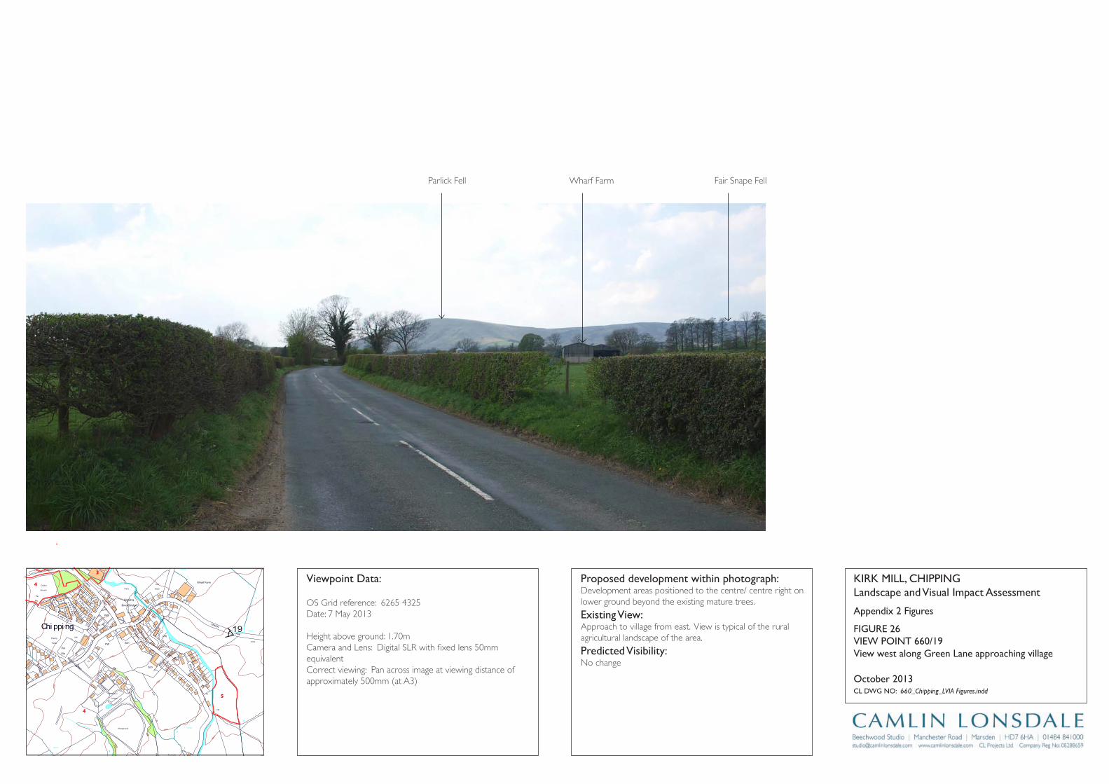
Track
Wharf Farm
Chipping
Brook Bridge
Grove Square
Meadow
Hey
Hawthorns
Track
Issues
Black Hall
Croft
Path
Iss
Isaacs
House
Tk
Pat
h
Drain
Drain
Track
Farm
Works
Sinks
Blackhall
CG
Dairy Barn
Dairy Farm
Drain
Dr ain
Drain
Drain
Drain
Drain
Drain
FB
FB
FB
FB
FB
Fairhaven
Farm
Ferry Butts
Green
Grove
Harling House
Highfield
Hill Clough
Holton Hill
House
Isaac's Farm
Issues
Issues
Issues
Issues
Issues
Issues
Issues
Issues
Issues
Issues
Issues
Issues
Issues
Issues
Issues
Issues
Issues
Issues
Issues
Issues
Issues
Issues
CT
DLEI
FK
OO
RB
DL
EIF
KRI
K
SD
NALK
RIK
CT
SYDEEWT
DLEI
FK
RIK
SD
NALK
OO
RB
KIRK
LAND
S
TE
ERTS
YD
NIW
EN
AL
SWINGLEHURST
DLEIFKRIK
WO
RB
NLI
KTL
AM
TEE
RTS
T
OBLAT
WODAEM
BROAD
RAIKE
CHURCH
LANE
GREEN
EN
ALESUOHHSIF
LANE
HOUSE
KCAL
B
LANE
MOSS
DAOR
GNATSRAG
Issues
Issues
Issues
Issues
Issues
Issues
Issues
Issues
Issues
Issues
Issues
Issues
Issues
Kirk Mills
Lane Ends
Leag
ram
Bro
ok
Lingey Hill
Mill
Moss Side
Nan
Wolfen
Weirs
Weir
Weir
Weir
Weir
Weir
Top O'Saunders
Three
Startifants
Spr
Spr
Spr
Spr
Spr
Spr
Sluice
SlackSinks
Sinks
Sinks
Sinks
Sinks
Sinks
Sinks
Sinks
Sinks
Showground
Pat
h Path
Path
Path
Path
Path
Path
Path
Path
Path
Pat
h
Track
Track
Track
163m
163m
176m
162m
156m
169m
98m
97m
Austin
101m
96m
96m
102m
113m
97m
147m
134m
109m
169m
131m
139m
117m
107m
190m
185m
175m
170m
170m
165m
160m
195 m
155m
150m
145m 14 0m
1 35 m
130m
175m
165m
160m
145m
120m
110m
100m
140m
135m
125m
170m
160m
150m
140m
135m
130m
125m
100m
100m
105m
110m
115m
120m
100m
Holme
Paths
Fish
House
IssPath
Dob
son'
sBr
ook
Path
Path
Path
The Grove
King's Wood
Iss
Nan King's
Farm
Path
Path
Springs
House
Path
GP
After
Lee
Pat h
Sta
Pol
Cricket
Ground
Pav
Old
Hive
Sch
Sch
PW
PO
PW
Vic
The
Field
Iss
Path
Path
Path
Pat h
Abbot
Barn
Clark
House
Path
C h i p p i n gPW
Works
Pat
h
War
Meml
Iss
Iss
Leagram
Lodge
Path
Chi
ppin
gBr
ook
Path
Path
Iss
Brickhouse
Cottage
Issues
Leagram
Hall
IssCottage
Throstle Nest
GP
Cuthbert
Hill
Path
Radcliffe
Hall
Daub
Hall
Little Daub
Hall
The
Croft
Meridor
GP
Sewage
Works
Brookside
High
Head
Goose Lane
Cottages
New
Barnfield
Radcliffe Cottage
High Head
Wood
Valve House
Hotel
Moss Lane
House
125m
Path
Iss
Iss
HallPlaying
Fields
19
4
3
5
Appendix 2 Figures
KirK Mill, Chippinglandscape and Visual impact Assessment
Cl DWg nO: 660_Chipping_LVIA Figures.indd
October 2013
proposed development within photograph:Development areas positioned to the centre/ centre right on lower ground beyond the existing mature trees.
Existing View:Approach to village from east. View is typical of the rural agricultural landscape of the area.
predicted Visibility: No change
Viewpoint Data:
OS Grid reference: 6265 4325Date: 7 May 2013
Height above ground: 1.70mCamera and Lens: Digital SLR with fixed lens 50mm equivalentCorrect viewing: Pan across image at viewing distance of approximately 500mm (at A3)
View west along green lane approaching village
FigUrE 26ViEW pOinT 660/19
4
Parlick Fell Fair Snape FellWharf Farm
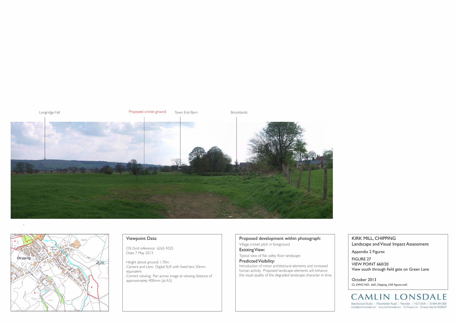
Track
Wharf Farm
Chipping
Brook Bridge
Grove Square
Meadow
Hey
Hawthorns
Track
Issues
Black Hall
Croft
Path
Iss
Isaacs
House
Tk
Pat
h
Drain
Drain
Track
Farm
Works
Sinks
Blackhall
CG
Dairy Barn
Dairy Farm
Drain
Dr ain
Drain
Drain
Drain
Drain
Drain
FB
FB
FB
FB
FB
Fairhaven
Farm
Ferry Butts
Green
Grove
Harling House
Highfield
Hill Clough
Holton Hill
House
Isaac's Farm
Issues
Issues
Issues
Issues
Issues
Issues
Issues
Issues
Issues
Issues
Issues
Issues
Issues
Issues
Issues
Issues
Issues
Issues
Issues
Issues
Issues
Issues
CT
DLEI
FK
OO
RB
DL
EIF
KRI
K
SD
NALK
RIK
CT
SYDEEWT
DLEI
FK
RIK
SD
NALK
OO
RB
KIRK
LAND
S
TE
ERTS
YD
NIW
EN
AL
SWINGLEHURST
DLEIFKRIK
WO
RB
NLI
KTL
AM
TEE
RTS
T
OBLAT
WODAEM
BROAD
RAIKE
CHURCH
LANE
GREEN
EN
ALESUOHHSIF
LANE
HOUSE
KCAL
B
LANE
MOSS
DAOR
GNATSRAG
Issues
Issues
Issues
Issues
Issues
Issues
Issues
Issues
Issues
Issues
Issues
Issues
Issues
Kirk Mills
Lane Ends
Leag
ram
Bro
ok
Lingey Hill
Mill
Moss Side
Nan
Wolfen
Weirs
Weir
Weir
Weir
Weir
Weir
Top O'Saunders
Three
Startifants
Spr
Spr
Spr
Spr
Spr
Spr
Sluice
SlackSinks
Sinks
Sinks
Sinks
Sinks
Sinks
Sinks
Sinks
Sinks
Showground
Pat
h Path
Path
Path
Path
Path
Path
Path
Path
Path
Pat
h
Track
Track
Track
163m
163m
176m
162m
156m
169m
98m
97m
Austin
101m
96m
96m
102m
113m
97m
147m
134m
109m
169m
131m
139m
117m
107m
190m
185m
175m
170m
170m
165m
160m
195 m
155m
150m
145m 14 0m
1 35 m
130m
175m
165m
160m
145m
120m
110m
100m
140m
135m
125m
170m
160m
150m
140m
135m
130m
125m
100m
100m
105m
110m
115m
120m
100m
Holme
Paths
Fish
House
IssPath
Dob
son'
sBr
ook
Path
Path
Path
The Grove
King's Wood
Iss
Nan King's
Farm
Path
Path
Springs
House
Path
GP
After
Lee
Pat h
Sta
Pol
Cricket
Ground
Pav
Old
Hive
Sch
Sch
PW
PO
PW
Vic
The
Field
Iss
Path
Path
Path
Pat h
Abbot
Barn
Clark
House
Path
C h i p p i n gPW
Works
Pat
h
War
Meml
Iss
Iss
Leagram
Lodge
Path
Chi
ppin
gBr
ook
Path
Path
Iss
Brickhouse
Cottage
Issues
Leagram
Hall
IssCottage
Throstle Nest
GP
Cuthbert
Hill
Path
Radcliffe
Hall
Daub
Hall
Little Daub
Hall
The
Croft
Meridor
GP
Sewage
Works
Brookside
High
Head
Goose Lane
Cottages
New
Barnfield
Radcliffe Cottage
High Head
Wood
Valve House
Hotel
Moss Lane
House
125m
Path
Iss
Iss
HallPlaying
Fields20
4
3
5
Appendix 2 Figures
KirK Mill, Chippinglandscape and Visual impact Assessment
Cl DWg nO: 660_Chipping_LVIA Figures.indd
October 2013
proposed development within photograph:Village cricket pitch in foreground
Existing View:Typical view of flat valley floor landscape
predicted Visibility: Introduction of minor architectural elements and increased human activity. Proposed landscape elements will enhance the visual quality of the degraded landscape character in time.
Viewpoint Data:
OS Grid reference: 6265 4325Date: 7 May 2013
Height above ground: 1.70mCamera and Lens: Digital SLR with fixed lens 50mm equivalentCorrect viewing: Pan across image at viewing distance of approximately 400mm (at A3)
View south through field gate on Green Lane
FigUrE 27ViEW pOinT 660/20
4
Proposed cricket groundLongridge Fell Town End Barn Brooklands
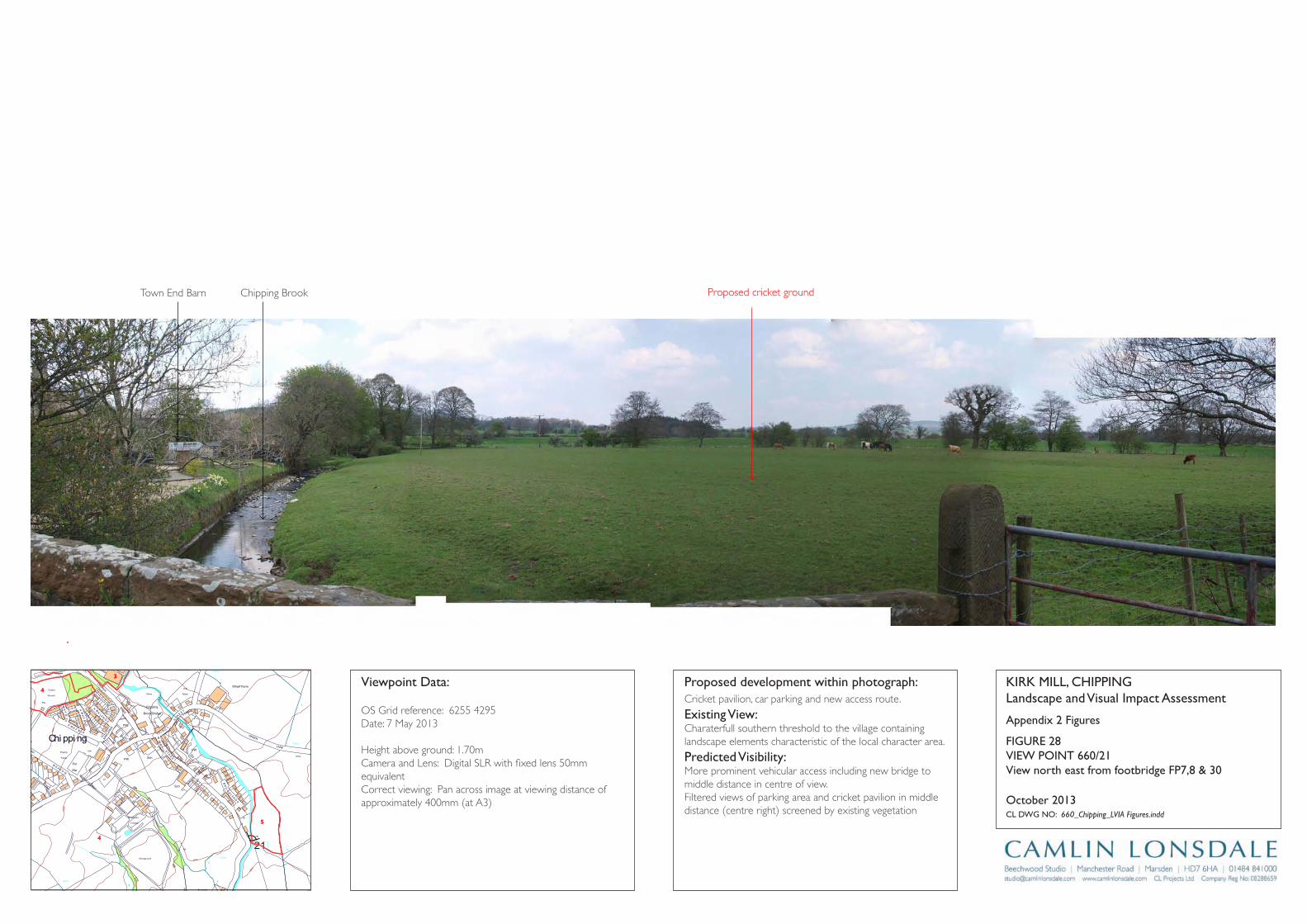
Track
Wharf Farm
Chipping
Brook Bridge
Grove Square
Meadow
Hey
Hawthorns
Track
Issues
Black Hall
Croft
Path
Iss
Isaacs
House
Tk
Pat
h
Drain
Drain
Track
Farm
Works
Sinks
Blackhall
CG
Dairy Barn
Dairy Farm
Drain
Dr ain
Drain
Drain
Drain
Drain
Drain
FB
FB
FB
FB
FB
Fairhaven
Farm
Ferry Butts
Green
Grove
Harling House
Highfield
Hill Clough
Holton Hill
House
Isaac's Farm
Issues
Issues
Issues
Issues
Issues
Issues
Issues
Issues
Issues
Issues
Issues
Issues
Issues
Issues
Issues
Issues
Issues
Issues
Issues
Issues
Issues
Issues
CT
DLEI
FK
OO
RB
DL
EIF
KRI
K
SD
NALK
RIK
CT
SYDEEWT
DLEI
FK
RIK
SD
NALK
OO
RB
KIRK
LAND
S
TE
ERTS
YD
NIW
EN
AL
SWINGLEHURST
DLEIFKRIK
WO
RB
NLI
KTL
AM
TEE
RTS
T
OBLAT
WODAEM
BROAD
RAIKE
CHURCH
LANE
GREEN
EN
ALESUOHHSIF
LANE
HOUSE
KCAL
B
LANE
MOSS
DAOR
GNATSRAG
Issues
Issues
Issues
Issues
Issues
Issues
Issues
Issues
Issues
Issues
Issues
Issues
Issues
Kirk Mills
Lane Ends
Leag
ram
Bro
ok
Lingey Hill
Mill
Moss Side
Nan
Wolfen
Weirs
Weir
Weir
Weir
Weir
Weir
Top O'Saunders
Three
Startifants
Spr
Spr
Spr
Spr
Spr
Spr
Sluice
SlackSinks
Sinks
Sinks
Sinks
Sinks
Sinks
Sinks
Sinks
Sinks
Showground
Pat
h Path
Path
Path
Path
Path
Path
Path
Path
Path
Pat
h
Track
Track
Track
163m
163m
176m
162m
156m
169m
98m
97m
Austin
101m
96m
96m
102m
113m
97m
147m
134m
109m
169m
131m
139m
117m
107m
190m
185m
175m
170m
170m
165m
160m
195 m
155m
150m
145m 14 0m
1 35 m
130m
175m
165m
160m
145m
120m
110m
100m
140m
135m
125m
170m
160m
150m
140m
135m
130m
125m
100m
100m
105m
110m
115m
120m
100m
Holme
Paths
Fish
House
IssPath
Dob
son'
sBr
ook
Path
Path
Path
The Grove
King's Wood
Iss
Nan King's
Farm
Path
Path
Springs
House
Path
GP
After
Lee
Pat h
Sta
Pol
Cricket
Ground
Pav
Old
Hive
Sch
Sch
PW
PO
PW
Vic
The
Field
Iss
Path
Path
Path
Pat h
Abbot
Barn
Clark
House
Path
C h i p p i n gPW
Works
Pat
h
War
Meml
Iss
Iss
Leagram
Lodge
Path
Chi
ppin
gBr
ook
Path
Path
Iss
Brickhouse
Cottage
Issues
Leagram
Hall
IssCottage
Throstle Nest
GP
Cuthbert
Hill
Path
Radcliffe
Hall
Daub
Hall
Little Daub
Hall
The
Croft
Meridor
GP
Sewage
Works
Brookside
High
Head
Goose Lane
Cottages
New
Barnfield
Radcliffe Cottage
High Head
Wood
Valve House
Hotel
Moss Lane
House
125m
Path
Iss
Iss
HallPlaying
Fields
21
Appendix 2 Figures
KirK Mill, Chippinglandscape and Visual impact Assessment
Cl DWg nO: 660_Chipping_LVIA Figures.indd
October 2013
proposed development within photograph:Cricket pavilion, car parking and new access route.
Existing View:Charaterfull southern threshold to the village containing landscape elements characteristic of the local character area.
predicted Visibility: More prominent vehicular access including new bridge to middle distance in centre of view.Filtered views of parking area and cricket pavilion in middle distance (centre right) screened by existing vegetation
Viewpoint Data:
OS Grid reference: 6255 4295Date: 7 May 2013
Height above ground: 1.70mCamera and Lens: Digital SLR with fixed lens 50mm equivalentCorrect viewing: Pan across image at viewing distance of approximately 400mm (at A3)
View north east from footbridge Fp7,8 & 30
FigUrE 28ViEW pOinT 660/21
4
3
5
4
Town End Barn Chipping Brook Proposed cricket ground
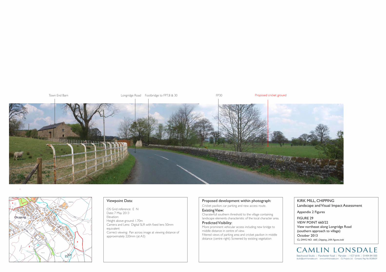
Track
Wharf Farm
Chipping
Brook Bridge
Grove Square
Meadow
Hey
Hawthorns
Track
Issues
Black Hall
Croft
Path
Iss
Isaacs
House
Tk
Pat
h
Drain
Drain
Track
Farm
Works
Sinks
Blackhall
CG
Dairy Barn
Dairy Farm
Drain
Dr ain
Drain
Drain
Drain
Drain
Drain
FB
FB
FB
FB
FB
Fairhaven
Farm
Ferry Butts
Green
Grove
Harling House
Highfield
Hill Clough
Holton Hill
House
Isaac's Farm
Issues
Issues
Issues
Issues
Issues
Issues
Issues
Issues
Issues
Issues
Issues
Issues
Issues
Issues
Issues
Issues
Issues
Issues
Issues
Issues
Issues
Issues
CT
DLEI
FK
OO
RB
DL
EIF
KRI
K
SD
NALK
RIK
CT
SYDEEWT
DLEI
FK
RIK
SD
NALK
OO
RB
KIRK
LAND
S
TE
ERTS
YD
NIW
EN
AL
SWINGLEHURST
DLEIFKRIK
WO
RB
NLI
KTL
AM
TEE
RTS
T
OBLAT
WODAEM
BROAD
RAIKE
CHURCH
LANE
GREEN
EN
ALESUOHHSIF
LANE
HOUSE
KCAL
B
LANE
MOSS
DAOR
GNATSRAG
Issues
Issues
Issues
Issues
Issues
Issues
Issues
Issues
Issues
Issues
Issues
Issues
Issues
Kirk Mills
Lane Ends
Leag
ram
Bro
ok
Lingey Hill
Mill
Moss Side
Nan
Wolfen
Weirs
Weir
Weir
Weir
Weir
Weir
Top O'Saunders
Three
Startifants
Spr
Spr
Spr
Spr
Spr
Spr
Sluice
SlackSinks
Sinks
Sinks
Sinks
Sinks
Sinks
Sinks
Sinks
Sinks
Showground
Pat
h Path
Path
Path
Path
Path
Path
Path
Path
Path
Pat
h
Track
Track
Track
163m
163m
176m
162m
156m
169m
98m
97m
Austin
101m
96m
96m
102m
113m
97m
147m
134m
109m
169m
131m
139m
117m
107m
190m
185m
175m
170m
170m
165m
160m
195 m
155m
150m
145m 14 0m
1 35 m
130m
175m
165m
160m
145m
120m
110m
100m
140m
135m
125m
170m
160m
150m
140m
135m
130m
125m
100m
100m
105m
110m
115m
120m
100m
Holme
Paths
Fish
House
IssPath
Dob
son'
sBr
ook
Path
Path
Path
The Grove
King's Wood
Iss
Nan King's
Farm
Path
Path
Springs
House
Path
GP
After
Lee
Pat h
Sta
Pol
Cricket
Ground
Pav
Old
Hive
Sch
Sch
PW
PO
PW
Vic
The
Field
Iss
Path
Path
Path
Pat h
Abbot
Barn
Clark
House
Path
C h i p p i n gPW
Works
Pat
h
War
Meml
Iss
Iss
Leagram
Lodge
Path
Chi
ppin
gBr
ook
Path
Path
Iss
Brickhouse
Cottage
Issues
Leagram
Hall
IssCottage
Throstle Nest
GP
Cuthbert
Hill
Path
Radcliffe
Hall
Daub
Hall
Little Daub
Hall
The
Croft
Meridor
GP
Sewage
Works
Brookside
High
Head
Goose Lane
Cottages
New
Barnfield
Radcliffe Cottage
High Head
Wood
Valve House
Hotel
Moss Lane
House
125m
Path
Iss
Iss
HallPlaying
Fields
22
4
3
5
Appendix 2 Figures
KirK Mill, Chippinglandscape and Visual impact Assessment
Cl DWg nO: 660_Chipping_LVIA Figures.indd
October 2013
proposed development within photograph:Cricket pavilion, car parking and new access route.
Existing View:Charaterfull southern threshold to the village containing landscape elements characteristic of the local character area.
predicted Visibility: More prominent vehicular access including new bridge to middle distance in centre of view.Filtered views of parking area and cricket pavilion in middle distance (centre right). Screened by existing vegetation
Viewpoint Data:
OS Grid reference: E NDate: 7 May 2013Elevation:Height above ground: 1.70mCamera and Lens: Digital SLR with fixed lens 50mm equivalentCorrect viewing: Pan across image at viewing distance of approximately 220mm (at A3)
View northeast along longridge road (southern approach to village)
FigUrE 29ViEW pOinT 660/22
4
Town End Barn Longridge Road Footbridge to FP7,8 & 30 FP30 Proposed cricket ground
619 Chipping 28 Landscape and Visual Impact Assessment 131024
APPENDIX 1: METHODOLOGY
1.1 The first stage of the assessment reviewed the existing landscape and visual resource (baseline landscape and visual conditions), through a process of research (desk study and field survey), classification of landscape type and character, and analysis. The baseline study also identified any observable dynamics within the landscape that indicated the likely future character of the area without the proposed development.
1.11 The area within which the proposed development may affect landscape character (the landscape context) was addressed as well as the development site itself.
1.111 The landscape baseline desk study considered:
• Landform • Land cover • Land use • Built development • Designations, conservation areas, features of architectural importance • Any identifiable special interests such as nature conservation, historical or
cultural heritage associations • How the study area has evolved over time
1.1V Sources referenced include:
• National Landscape related Designations • Natural England’s National Character Areas • District and local level Character Areas where available • Public Rights of Way • Local OS Maps • Aerial Photographs
1.V A field survey was conducted on 7th May 2013 to confirm the extent of the study area and the baseline conditions identified by the desk study and identified landscape character areas within the study area. A standard survey form was used to record observations from selected viewpoints across the study area on:
• Objective description and subjective impression • Landscape condition • Land use • Management • Trends for change • Identification of any specific sensitive receptors directly or indirectly affected
by the proposed development and assessment of their value if practicable.
1.V1 The analysis process described and assessed individual elements, features or characteristics of the landscape, their condition (state) and value or importance and how they interact to create the landscape character. Any potential for landscape enhancement (such as restoration of features that have declined) was identified.
619 Chipping 29 Landscape and Visual Impact Assessment 131024
1.V11 The study area for the visual baseline represents the area within which the views affected by the proposed development are expected to be of interest or concern.
1.V111 The visual baseline desk study identified:
• Nature of the visual amenity • Approximate extent of visibility of development • Specific potential receptors of visual effects (residents, visitors, road users
etc)
1.1X A field survey was conducted on 7th May 2013 to:
• Identify receptors by looking outwards from the site; considering both public and private viewpoints
• Check extent of visibility with reference to the siting and dimensions of the proposed development (reviewed as design proposals are amended)
• Identify principal representative viewpoints • Record types of viewers affected, numbers where appropriate, and duration
of view • Record views of and from valued landscapes • Identify potential seasonal screening effects
1.X The analysis process:
• Identified the extent and nature of existing views of the site • Identified the nature and characteristics of the visual amenity of the
potentially sensitive visual receptors • Sought agreement with the authority on the viewpoints to be represented
in photomontages • Mapped viewpoints and features interrupting/filtering/influencing views • Described important characteristics of each view • Described changes that will arise as a result of development
1.X1 The sensitivity of the landscape resource, i.e. the degree to which a particular landscape type or area can accommodate the change arising from the proposed development, was then assessed. Each key element or characteristic of the landscape likely to be affected was evaluated, considering its quality, value and contribution to landscape character, the degree to which it can be replaced or substituted, and any scope for mitigation. A sensitivity table comprised of a list of the landscape receptors with the sensitivity and value of each rated high, moderate, or low according to definitions in table Ap. 1.1
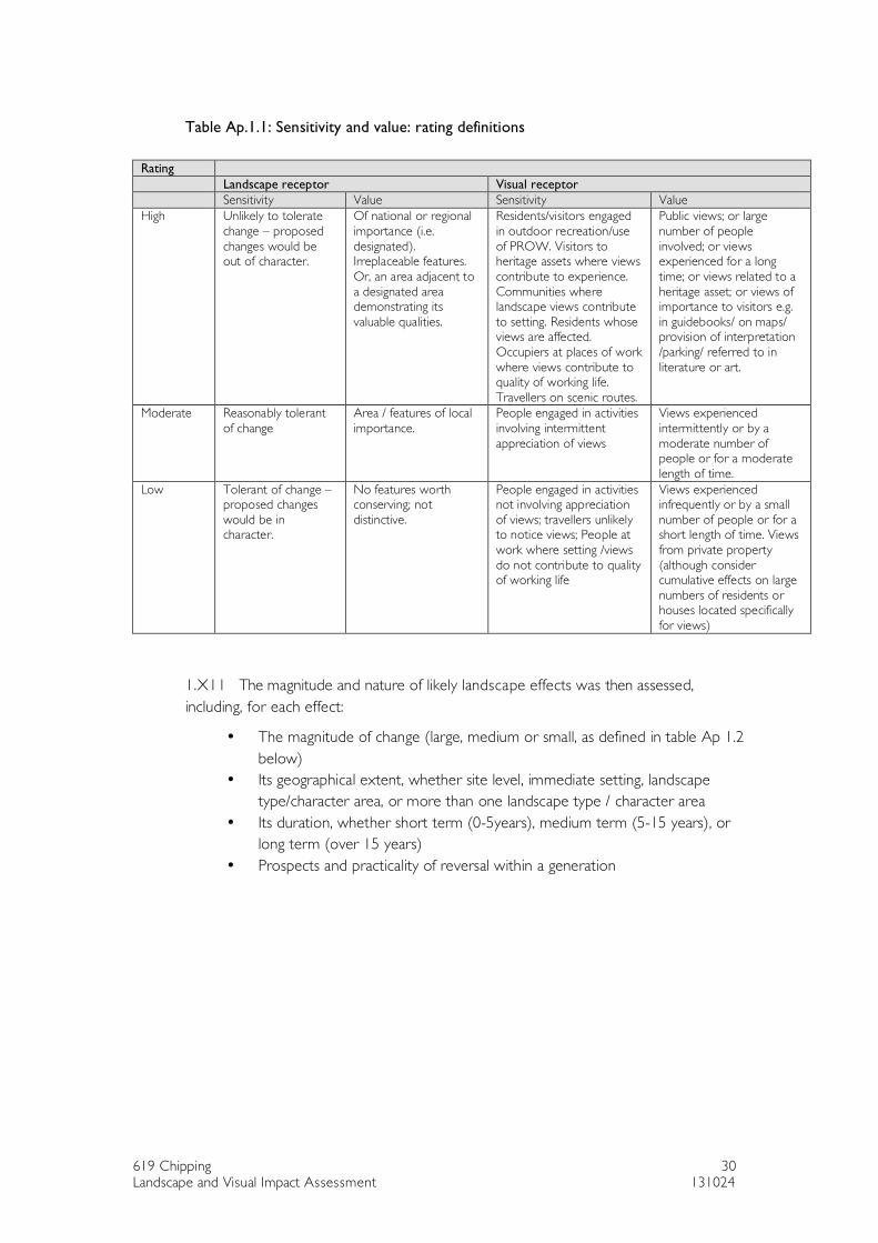
619 Chipping 30 Landscape and Visual Impact Assessment 131024
Table Ap.1.1: Sensitivity and value: rating definitions
Rating Landscape receptor Visual receptor Sensitivity Value Sensitivity Value High Unlikely to tolerate
change – proposed changes would be out of character.
Of national or regional importance (i.e. designated). Irreplaceable features. Or, an area adjacent to a designated area demonstrating its valuable qualities.
Residents/visitors engaged in outdoor recreation/use of PROW. Visitors to heritage assets where views contribute to experience. Communities where landscape views contribute to setting. Residents whose views are affected. Occupiers at places of work where views contribute to quality of working life. Travellers on scenic routes.
Public views; or large number of people involved; or views experienced for a long time; or views related to a heritage asset; or views of importance to visitors e.g. in guidebooks/ on maps/ provision of interpretation /parking/ referred to in literature or art.
Moderate Reasonably tolerant of change
Area / features of local importance.
People engaged in activities involving intermittent appreciation of views
Views experienced intermittently or by a moderate number of people or for a moderate length of time.
Low Tolerant of change – proposed changes would be in character.
No features worth conserving; not distinctive.
People engaged in activities not involving appreciation of views; travellers unlikely to notice views; People at work where setting /views do not contribute to quality of working life
Views experienced infrequently or by a small number of people or for a short length of time. Views from private property (although consider cumulative effects on large numbers of residents or houses located specifically for views)
1.X11 The magnitude and nature of likely landscape effects was then assessed, including, for each effect:
• The magnitude of change (large, medium or small, as defined in table Ap 1.2 below)
• Its geographical extent, whether site level, immediate setting, landscape type/character area, or more than one landscape type / character area
• Its duration, whether short term (0-5years), medium term (5-15 years), or long term (over 15 years)
• Prospects and practicality of reversal within a generation
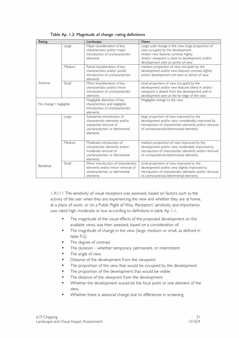
619 Chipping 31 Landscape and Visual Impact Assessment 131024
Table Ap. 1.2: Magnitude of change: rating definitions
Rating Landscape Views Large Major loss/alteration of key
characteristics and/or major introduction of uncharacteristic elements
Large scale change in the view; large proportion of view occupied by the development And/or new features contrast highly; And/or viewpoint is close to development and/or development seen at centre of view
Medium Partial loss/alteration of key characteristics and/or partial introduction of uncharacteristic elements
medium proportion of view occupied by the development and/or new features contrast slightly and/or development not seen at centre of view
Adverse Small Minor loss/alteration of key
characteristics and/or minor introduction of uncharacteristic elements
small proportion of view occupied by the development and/or new features blend in and/or viewpoint is distant from the development and or development seen at the far edge of the view
No change / negligible
Negligible alteration of key characteristics and negligible introduction of uncharacteristic elements
Negligible change to the view
Large Substantial introduction of characteristic elements and/or substantial removal of uncharacteristic or detrimental elements
large proportion of view improved by the development and/or view considerably improved by introduction of characteristic elements and/or removal of uncharacteristic/detrimental elements
Medium Moderate introduction of characteristic elements and/or moderate removal of uncharacteristic or detrimental elements
medium proportion of view improved by the development and/or view moderately improved by introduction of characteristic elements and/or removal of uncharacteristic/detrimental elements
Beneficial
Small Minor introduction of characteristic elements and/or minor removal of uncharacteristic or detrimental elements
small proportion of view improved by the development and/or view slightly improved by introduction of characteristic elements and/or removal of uncharacteristic/detrimental elements
1.X111 The sensitivity of visual receptors was assessed, based on factors such as the activity of the user when they are experiencing the view and whether they are at home, at a place of work, or on a Public Right of Way. Receptors’ sensitivity and importance was rated high, moderate or low according to definitions in table Ap 1.1.
• The magnitude of the visual effects of the proposed development on the available views was then assessed, based on a consideration of:
• The magnitude of change in the view (large, medium or small, as defined in table 9.2)
• The degree of contrast • The duration – whether temporary, permanent, or intermittent • The angle of view • Distance of the development from the viewpoint • The proportion of the view that would be occupied by the development • The proportion of the development that would be visible • The distance of the viewpoint from the development • Whether the development would be the focal point or one element of the
view. • Whether there is seasonal change due to differences in screening.
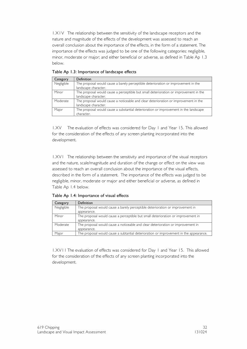
619 Chipping 32 Landscape and Visual Impact Assessment 131024
1.X1V The relationship between the sensitivity of the landscape receptors and the nature and magnitude of the effects of the development was assessed to reach an overall conclusion about the importance of the effects, in the form of a statement. The importance of the effects was judged to be one of the following categories: negligible, minor, moderate or major; and either beneficial or adverse, as defined in Table Ap 1.3 below.
Table Ap 1.3: Importance of landscape effects
Category Definition Negligible The proposal would cause a barely perceptible deterioration or improvement in the
landscape character. Minor The proposal would cause a perceptible but small deterioration or improvement in the
landscape character. Moderate The proposal would cause a noticeable and clear deterioration or improvement in the
landscape character. Major The proposal would cause a substantial deterioration or improvement in the landscape
character.
1.XV The evaluation of effects was considered for Day 1 and Year 15. This allowed for the consideration of the effects of any screen planting incorporated into the development.
1.XV1 The relationship between the sensitivity and importance of the visual receptors and the nature, scale/magnitude and duration of the change or effect on the view was assessed to reach an overall conclusion about the importance of the visual effects, described in the form of a statement. The importance of the effects was judged to be negligible, minor, moderate or major and either beneficial or adverse, as defined in Table Ap 1.4 below.
Table Ap 1.4: Importance of visual effects
Category Definition Negligible The proposal would cause a barely perceptible deterioration or improvement in
appearance. Minor The proposal would cause a perceptible but small deterioration or improvement in
appearance. Moderate The proposal would cause a noticeable and clear deterioration or improvement in
appearance. Major The proposal would cause a subtantial deterioration or improvement in the appearance.
1.XV11 The evaluation of effects was considered for Day 1 and Year 15. This allowed for the consideration of the effects of any screen planting incorporated into the development.