land use, spatial planning, and potential implications for ... resodudarmo.pdf · land use, spatial...
TRANSCRIPT
THINKING beyond the canopy
Land use, spatial planning, and potential implications for
REDD+ in Indonesia: A preliminary analysis
Ida Aju Pradnja Resosudarmo
Pekanbaru, May 11, 2012

THINKING beyond the canopy
Context-1: the Forest Area
Source: Directorate of General of Planning, MoF, 2010
187 MHa land area
133 MHa Forest Area
(71%) 40 MHa
Not Forested
93 MHa Forested
54 MHa Non-Forest Area
(29%)
45.6 MHa
Not Forested
8.4 MHa Forested
Under the purview of the MOF
Local govt and National Land Agency

THINKING beyond the canopy
Context-2
Large area of forests but high DD also means high GHG emissions
Commitment of 26% emission reduction by 2020:
• >80% reduction earmarked from forests and peatlands (National
Action Plan for GHG emission reductions);
• reduction target from other sectors small
Forest lands provide the base for Indonesia’s NR-focused
development and livelihood activities
THINKING beyond the canopy
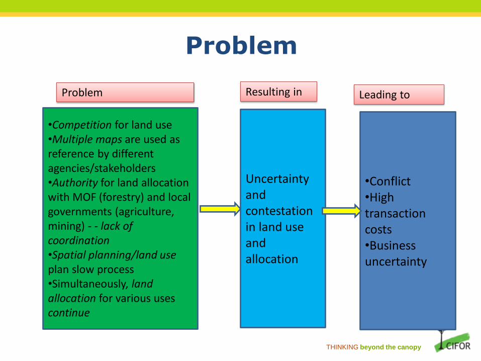
Problem
•Competition for land use •Multiple maps are used as reference by different agencies/stakeholders •Authority for land allocation with MOF (forestry) and local governments (agriculture, mining) - - lack of coordination •Spatial planning/land use plan slow process •Simultaneously, land allocation for various uses continue
Uncertainty and contestation in land use and allocation
•Conflict •High transaction costs •Business uncertainty
Problem Resulting in Leading to

THINKING beyond the canopy
Pressure on forests: competition for land use
Agro-industrial development
• Vast areas of forest conversion
Yet some 30 MHa of unproductive lands are available
Mining
• Smaller in terms of area but in effect significant implications for forests
Disconnected vertical and horizontal policies and objectives

THINKING beyond the canopy
Oil palm expansion (1)
-
1,000
2,000
3,000
4,000
1970 1980 1990 2000 2005 2006 2007 2008 2009 2010
Smallholders Government Private
(000 Ha)
-
5,000
10,000
1970 1980 1990 2000 2005 2006 2007 2008 2009 2010
Smallholders Government Private
(000 Tonnes)
Plantation
Production
Source : Ministry of Agriculture (2011)

THINKING beyond the canopy
Oil palm expansion (2)
- Until 2010, MOF data show 4.9 MHa of forest area have been released for
plantation
- Up until mid 2010, regional governments in Sumatra, Kalimantan and Sulawesi
proposed land use change over 16.5 MHa of forests
- In Central Kalimantan 3.9 MHa of oil palm establishments are located in areas
that have not been released from the Forest Area by the MOF (and therefore
Illegal??)
- Issues:
- Licensing procedures not followed
- Local Governments authority vs Central Government
- Sectoral laws and objectives
- No agreed-upon reference maps: spatial plans (RTRWP/Ks) vs TGHK
-

THINKING beyond the canopy
Coal Mining
• > 40% of domestic power supply
• 74% for export
• Largely in forests
Year
Power Station from Coal (GWh) %
Electricity Production Total of all Power
Station (GWh)
2005 51,793 41 127,371
2006 58,630 44 133,109
2007 63,817 45 142,440
2008 61,392 41 149,438
2009 64,976 42 155,333
2010 68,041 41 165,621
-
50
100
150
200
250
300
2000 2001 2002 2003 2004 2005 2006 2007 2008 2009 2010
Production Export
(million Tonnes)
Source : Ministry of Energy and Mineral Resources (2011)

THINKING beyond the canopy
Mining in Central Kalimantan
Unit Area (Ha)
With forest lease permits 9 31,747
Without forest lease permits 606 3,719,871
Total 615 3,751,619
Forest Area based on TGHK 15,300,000
Mining threatens 25% of the Forest Area (kawasan hutan) in Central Kalimantan

THINKING beyond the canopy
Mining in forests
MOF sets a 10% limit on mining operations in a given (Production) forest area
Between 2005 and May 2011, the MOF issued lease use permits for 459.8 Kha for
exploitation and 1.58 Mha for exploration in forest area
However
For all Kalimantan, the MOF reports of 903 units of mining operations in over 5.3 Mha
operating illegally/without going through legal procedures.
Mining licenses are mostly issued by local governments
• Different maps are used
• Licenses often overlap with each other.
• 8,000 licenses issued by local governments were reportedly problematic
(Rakhmanto 2011).
Small scale ‘illegal’ mining operations are also increasing and persistent
Spatial plan still in process

THINKING beyond the canopy
Master Plan for the Acceleration and Extension of Indonesia’s economy

THINKING beyond the canopy
First phase
1982: Forest Use by Consensus (TGHK).
The TGHK maps were macro and indicative
maps vs reality of land use
Second phase 1992: Spatial planning Law
attempts to synchronize the TGHK and RTRWP (padu serasi)
important provinces never completed their paduserasi or have them
approved by MOF (e.g., Riau, Central Kalimantan)
Third phase
1999: New Forestry Law
reemphasizes MOF’s ‘purview’ over the Forest Area
Fourth phase
2007: New Spatial Planning Law
“RTRWPs shall be completed in 2 years (i.e., 2009); RTRWKs in 3years
(i.e., 2010)”
During which (mostly ad-hoc) rapid development and livelihood activities occur, and
intensified under regional autonomy
Forest and Land-use Planning

THINKING beyond the canopy
Problems (1) Many problems associated with the use of TGHK maps as reference for development
planning in regions:
• Incomplete demarcation of Forest Area boundaries (only 11.74% gazetted)
• What about the people who have and/or are living in the area claiming their
rights?
Slow process of paduserasi between TGHK and RTRWP or in reformulating of
RTRWP particularly in forested provinces because of complexity of existing land
uses/allocation; e.g., existing uses not compatible with TGHK etc.
As of May 8, 2012, only 13 out 33 provinces have had their RTRWPs approved
Riau, Aceh, all of Kalimantan provinces, and Papua and West Papua have not
completed their spatial plans (or have them approved): all ‘stuck’ in relation to
Forest Area
Thus, forested provinces have no (vertically and horizontally) agreed-upon reference
on which to base their development plans

THINKING beyond the canopy
Problems (2)
Meanwhile activities and development in the regions continue: oil palm (local
government), mining (local and CG), forestry (CG).
Exacerbating existing overlapping land-uses, promoting conflicts on the ground,
disconnect between sectors due to the different reference maps used and
different objectives
Local governments use maps that are advantageous to them: Legal status of
Forest Area officially challenged by local governments (Central Kalimantan
districts)
Slow process of RTWP/Ks leads to continuing uncertainty of forest and land
status in the regions
• Implications on the issuance of forestry and non-forestry licenses; including
REDD+ projects
• Implications on local communities’ tenure and activities
Hampers the implementation of land and natural resource-based development
policies

THINKING beyond the canopy
E.g. Central Kalimantan
TGHK – referred to by MOF RTRWP 2003 – referred to by local government

THINKING beyond the canopy
Prior to the establishment of REDD+ projects:
Difficulties in identifying areas with a reasonable degree of certainty
over their use and rights
Proponents will require a considerable degree of certainty that there will
be no other developments over the same forest area that may overturn
the REDD+ license during its lifetime.
Implications for REDD+ (1)
THINKING beyond the canopy
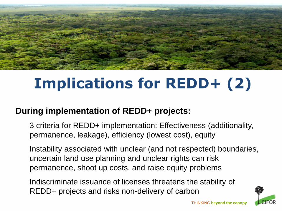
Implications for REDD+ (2)
During implementation of REDD+ projects:
3 criteria for REDD+ implementation: Effectiveness (additionality,
permanence, leakage), efficiency (lowest cost), equity
Instability associated with unclear (and not respected) boundaries,
uncertain land use planning and unclear rights can risk
permanence, shoot up costs, and raise equity problems
Indiscriminate issuance of licenses threatens the stability of
REDD+ projects and risks non-delivery of carbon
THINKING beyond the canopy
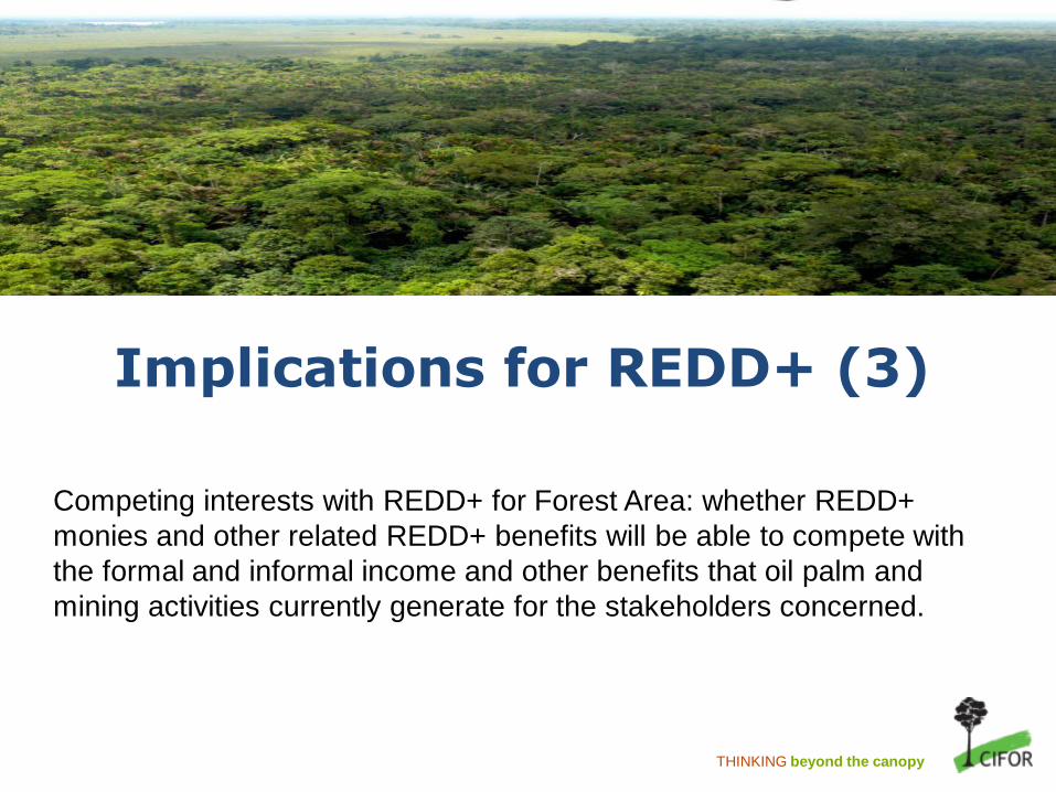
Implications for REDD+ (3)
Competing interests with REDD+ for Forest Area: whether REDD+
monies and other related REDD+ benefits will be able to compete with
the formal and informal income and other benefits that oil palm and
mining activities currently generate for the stakeholders concerned.

THINKING beyond the canopy
(BIG) Homework
Agreed-upon and respected land and forest maps
What to do with the numerous existing overlapping land uses?
How to uphold and implement consistent policies and regulations across sectors
• E.g. moratorium of forest and peat land conversion; MP3EI with its 6 corridors, provincial spatial planning with island-based spatial plans
Improving governance and vertical relations

THINKING beyond the canopy
Thank you