land use - placer county, california
TRANSCRIPT
.
CHAPTER THREE
LAND USE


Granite Bay Community Plan LAND USE
Page | 25
3. Land Use The purpose of the Land U se section is to provide goals and p olicies that address the unique land use issues of the Plan area that are not included in the Placer County General Plan. Land use policies contribute fundamentally to the character and form of a community. This section of the Granite Bay Community Plan identifies the various land use districts as well as goals and policies established herein to implement the Plan. Permitted densities in those areas are affected by policies of other sections, particularly the public services chapter. Similarly, other portions of the Plan are directly affected by the Land Use chapter. For example, the need for schools, fire stations, park facilities and c irculation system improvements is based on the cumulative density identified by the location and size of the various land use districts. The Granite Bay community has a r eputation as a visually pleasing, rural-residential area. The principal elements are the rural countryside, rolling terrain, country roads, natural stream corridors, fields of wild grasses and wildflowers, scenic vistas, oak woodlands , large lots, and graceful buildings which are subordinate in appearance to the land. With the continuing growth in many of the county’s rural areas, the importance of protecting rural features and preserving open space has become increasingly important to Granite Bay residents. Policies in this section have been formulated to enhance the rural and natural qualities of this unique community. Land use policies are designed to prevent overuse of land and control intensity of use. The overuse or overcrowding of individual sites with buildings, structures and/or accessory uses can create environmental impacts such as excessive traffic, drainage problems, soil erosion, loss of vegetation and other resources, and can destroy the open, rolling terrain, and natural characteristics of a community. The perception of land use intensity is generally identifiable by: population density, building coverage, extent of impervious surfaces, public service requirements, traffic movements, topography, natural hazards, fire safety, and natural resources.
3.1 GOALS
1. Preserve the unique character of the Granite Bay area which is exemplified by the general rural environment, oak woodlands, mix of land uses and densities, and high quality of development.
2. Require planning and design that ensures compatibility among neighboring land uses.
3. Commercial uses should serve local community needs and s hould not detract from the rural-residential setting.
Figure 3.0.1: Granite Bay is home to several business and professional parks.

LAND USE Granite Bay Community Plan
Page | 26
4. Help maintain and support agricultural uses such as orchards, hobby farms, vineyards, animal raising, and horse ranches, etc.
5. Preserve and protect the natural waterways and watersheds, wetlands, riparian areas, floodplains, and oak woodlands.
6. New development shall provide appropriate infrastructure and meet County service standards.
7. Assure that all new buildings and residences are developed in a manner that minimizes disturbance to natural terrain and vegetation and maximizes preservation of (and/or enhances) natural beauty and open space.
8. Planned Residential Developments (“PD” or “PDs”) should be utilized to preserve significant natural resources, natural beauty, or open space, and unless appropriately located, properly sited and adequately buffered, without increasing the intensity of development otherwise possible.
9. Encourage environmentally sensitive design and sustainable approaches to development which promote natural resource conservation.
10. Encourage revitalization of aging commercial sites and consider the potential to provide a mix of civic, housing, commercial and/or employment opportunities to meet the changing needs of the community.
3.2 POLICIES 1. Maintain, encourage and support small (4.6 to 20 acres) family or hobby farms and ranches.
2. Locate high and m edium-density residential areas close to existing commercial services and along major transportation corridors where urban services are most efficiently provided.
3. Where permitted, utilize Planned Residential Developments to: protect environmentally sensitive areas; preserve natural, cultural and h istorical resources; conserve visual and aes thetic resources; maintain the local area’s quality of life; provide for an increasing variety of housing types, designs and layouts; efficiently use land; and, effectively develop and utilize public facilities and services.
4. Retain commercial centers at and adjacent to the intersections of Sierra College Boulevard and Douglas Boulevard and Auburn-Folsom Road and Douglas Boulevard.
5. Industrial development shall be discouraged in the Community Plan area.
6. Provide transitional land uses or a landscaped buffer wherever necessary to minimize the conflicts inherent to adjoining properties of different zoning intensity, density, or adverse uses.
7. Property shall be developed with minimum disturbance to the natural terrain. The natural environment shall be enhanced, retained or restored as much as possible.
8. The keeping of livestock, particularly horses, is one of many important components of the rural character of the community. Therefore, accessory structures for livestock may be appropriate in residential areas with a minimum lot size of one acre.
9. Buildings shall be of a size and scale conducive to the character of the immediate neighborhood.
10. Non-residential uses shall generally be of an appropriate size and scale for their setting and shall be designed to incorporate such elements such as plazas, terraces, porches, arcades or canopies to contribute to a pleasant environment as well as provide safety and shelter to pedestrians.

Granite Bay Community Plan LAND USE
Page | 27
11. To preserve the character of the community, land use changes shall be considered only if: a) The change can be designed and implemented to be consistent with the
contiguous properties. In determining consistency, all elements of the Community Plan shall be reviewed.
b) The change is consistent with or adequately buffered from contiguous properties and will provide for a reasonable transition between land uses.
c) The change shall not significantly impact the level of services provided in its vicinity and there is or will be adequate infrastructure to serve the proposed development.
d) The development is effectively screened so as to not be perceived by the public as high-density.
12. Non-residential structures, such as those supporting wind turbines, solar panels and cell phone towers, shall be designed so as to blend with the rural atmosphere of Granite Bay and neighboring developments and shall not adversely impact neighboring parcels.
Specific Policies for Intensity of Use 1. The planning area shall have the intensity of development which is appropriate to its location on
the fringe of the urban areas of the cities of Roseville and Rocklin and the County of Sacramento, and should provide a t ransition between the urban densities in the adjoining communities and non-intensive land uses to the north and west.
2. Population densities within the planning area should be guided by considerations of topography, geology, vegetative cover, preservation of natural terrain and resources, and access to transportation and service facilities.
3. Densities should not be increased unless there exists or are assured adequate services and infrastructure, including but not limited to potable water, sanitary sewer, roadways meeting County standards, police and fire.
4. Intensity of use of individual parcels and buildings shall be governed by considerations of health and safety; impact on adjoining properties due to noise, traffic, night lighting, or other disturbing conditions; and protection of natural land characteristics.
Specific Policies for Subdivision and Minor Land Division 1. The number of lots permitted in a subdivision is dependent on the specific characteristics of the
area, as well as the minimum lot area required by ordinance. However, the number of lots permitted by a zoning designation should be considered only as a maximum and i s not a guarantee of the density that is allowed.
2. An overriding consideration in the design of any subdivision project shall be the conservation of the natural slope, the conservation of natural drainage channels and swales (since they serve in place of artificial drainage systems), the preservation of existing natural resources including wildlife habitat, and preservation of cultural or historic resources.
3. Visibility of structures, preservation of natural land form and natural resources, topography, noise exposure, maintenance of rural quality and relationship to the surrounding properties, and access to transportation corridors and services shall all be considered in preparing subdivision designs. Subdivision density, or number of lots, will ultimately be determined by these factors.
4. Accessory uses shall be clearly subordinate to the main residence and should be in keeping with the particular residential characteristics of the specific location.
LAND USE Granite Bay Community Plan
Page | 28
5. Lots shall be a dequate in size and shape to accommodate those primary and accessory uses which are in keeping with the particular residential characteristics of the specific location without: a) Creating a feeling of overcrowding. b) Creating measurable negative environmental impacts which cannot be
adequately mitigated. c) Creating the need for variances.
6. Though creation of flag lots ((a parcel of land shaped like a flag, with a narrow strip (“flag pole”) providing access to a right-of-way and the bulk of the property (“flag” portion) containing no frontage)) is discouraged, they may be appropriate under the following circumstances: a) The proposed flag lot subdivision is the only reasonable subdivision design due to \
topographic conditions or other physical (e.g. special circumstances associated with the size and shape of the property) and natural constraints of the property (e.g. natural drainage course or streams, protected trees, etc);
b) A series of large lots cannot be converted to flag lot developments, thereby significantly raising the density and changing the character of the neighborhood;
c) The ‘flag’ portion of the lot cannot be further divided based on zoning; d) The lots created from the proposed flag lot subdivision shall be compatible with the size
and scale of the existing lots and lot configurations in the surrounding area; and, e) The design of the proposed subdivision complies with the conditions listed below and
other appropriate County standards and conditions as appropriate: i. Each flag lot shall be designed to provide a “pole” that functions as an accessway
from the street to the main body (“flag portion”) of the lot. Private access easements shall not be allowed;
ii. A minimum 25’ of frontage and width shall be maintained throughout the length of the pole and should be landscaped on both sides;
iii. Not more than two flag lot poles shall be contiguous to each other; and, iv. Each structure on a flag lot shall be oriented to maximize privacy to surrounding
existing and future residential structures.
Specific Policies for Planned Residential Developments 1. Residential lots on the perimeter of the Planned Residential Development shall be of similar size
and configuration as the existing adjoining lots and/or zoning district lot size minimums.
2. Entry features shall reflect their surrounding environment, utilizing indigenous materials for any walls, signs, or related entry features and native and/or native appearing plantings for landscaping.
3. PDs shall be designed to place streets and/or common area open space, rather than private back yards, next to perennial streams and riparian corridors.
4. Where a public park site is proposed to meet the recreational requirements of the PD, generally the park should be located near the project’s main entrance and/or as close as possible to a major roadway to facilitate public access.
5. Where sound attenuation is necessary, earthen berms and additional building setbacks shall be provided. Soundwalls are permitted only when no other feasible alternative is available and only if screened with mounding and/or landscaping such as vines.
6. PDs shall be designed to avoid lot grading where lots larger than 20,000 square feet are proposed. Lot grading may be more appropriate for lots smaller than 10,000 square feet to minimize cross drainage concerns, and s hould be considered on a project-by-project basis for lots ranging between 10,000 and 20,000 square feet.
Granite Bay Community Plan LAND USE
Page | 29
7. PDs should be designed to avoid long, straight roadways in favor of curvilinear designs that generally follow the natural landforms, are consistent with the Land Development Manual, and provide for landscape islands along some roads and/or within oversized cul-de-sacs if adequate turnarounds for emergency and service vehicles can be provided.
Specific Policies for Commercial Land Uses 1. Convenience goods and services and limited shopping goods shall be available in local shopping
centers in sufficient quantity and variety to meet the most frequently recurring needs of the residents of the Granite Bay community.
2. Uses which would attract a majority of patronage from outside the community area shall more appropriately be located in larger and more centrally sited commercial and office centers such as those located in the cities of Roseville and Folsom.
3. Buildings shall be of moderate size and scale and are encouraged to utilize timeless, traditional architectural styles such as Craftsman in their building design and comply with the Granite Bay Douglas Corridor Design Elements and Landscape Goals if applicable. Natural materials (i.e. wood, river cobble and fieldstone) and native plants shall be used where practicable.
4. Individual sites shall be landscaped attractively so as to integrate the entire development visually with the overall natural qualities of the site and its surrounds. Residential areas shall be protected from noise, light pollution, unsightliness, odor, and other nuisances. A ppropriately landscaped buffer areas of adequate size shall be provided to shield adjacent residential developments from activities on the properties.
5. Any night lighting shall be designed to reduce the impacts of glare, light trespass and over-lighting; promote safety and security; and encourage energy conservation. Generally, upward lighting shall only be permitted if it is low intensity (50 watts or less) and i t is either used to externally illuminate a freestanding sign or it is used as accent lighting for landscaping.
6. The use of roof lighting, cove lighting, and backlit awnings shall be strongly discouraged. Building eave lighting shall be recessed and shall not be continuous along any building elevation.
7. Parking spaces shall be grouped in moderately sized areas, and located close to the enterprises they are to serve. Traffic circulation within parking lots shall be efficient and safe.
8. Sites shall be designated and developed to provide safe, convenient, public access that accommodates pedestrians, bicyclists, motorists, and equestrians, where appropriate.
Specific Policies for Public and Private Institutions 1. Institutional uses shall be limited to those which provide non-commercial services or facilities for
local residents and contribute to the general well-being of the community.
2. The intensity of use of an institutional site shall be limited to that which is compatible with adjoining uses and in keeping with the particular characteristics of the specific location and the overall rural character of Granite Bay; the institution should not generate excessive noise or traffic.
3. Buildings shall be of moderate size and scale and are encouraged to utilize timeless, traditional architectural styles such as Craftsman in their building design and comply with the Granite Bay Douglas Corridor Design Elements and Landscape Goals if applicable. N atural materials (i.e. wood, river cobble and fieldstone) and native plants shall be used where practicable.
4. Sites shall be landscaped attractively; trees and other plantings should be used to screen adjacent residential areas from noise, light pollution, unsightliness, odor, and other nuisances; natural materials (i.e. wood, river cobble and fieldstone) and native plants shall be used where

LAND USE Granite Bay Community Plan
Page | 30
practicable. In particular, parking areas shall be s creened from view from roads and adj acent residential properties.
5. Public school facilities are encouraged to be available for community gatherings and recreation use, and should be available for use during non-school hours. When new schools are considered, sites should be adequate to accommodate local public recreation activities in addition to school uses.
Specific Policies for Parks and Recreation Land Uses 1. Parks and r ecreational areas shall be
planned, developed, and used in a manner which is in keeping with the particular residential characteristics of the specific location.
2. Recreation areas shall be located and designed so that access by pedestrians, equestrians, and cyclists is encouraged.
3. Natural open space recreation land within the planning area should be carefully managed and its uses controlled to ensure that vegetation, soil, wildlife, and visual qualities are protected and, where necessary and appropriate, enhanced.
4. Park and r ecreation areas shall be designed to limit noise, the impacts of glare, light trespass and over-lighting, and motor vehicle traffic both internally and externally.
5. Local recreational programs shall be responsive to the needs of Granite Bay residents.
Specific Policies for Preservation/Conservation of Natural Resources 1. Significant natural resources, wildlife
habitat, open space, and cultural resources should be identified, in advance of property development. Those resources should be protected and preserved based on goals and policies of this Plan and applicable state or federal laws.
2. Stream corridors must be kept free of structures and maintained in a natural condition, except for erosion and flood control measures and other uses compatible with stream corridors.
Figure 3.2.1: Treelake Village Park.
Figure 3.2.2: Oak Woodlands along Sierra College Boulevard overlooking Granite Bay.

Granite Bay Community Plan LAND USE
Page | 31
3.3 LAND USE DISTRICTS The goals and policies of the Granite Bay Community Plan are implemented in several ways and with the use of many different types of planning tools. This section identifies various categories of land use (i.e. land use districts) as the first step in implementation of the Plan. The Plan designations are then more specifically defined through the adoption of precise zoning of each parcel in the Plan area. In all cases, the zoning of property must be consistent with the Plan. For this reason, the zoning map was prepared along with the Community Plan map. The usefulness of the Community Plan depends upon the degree to which its goals and policies are implemented. Along with zoning ordinances, several other programs are necessary to implement the Plan. Capital improvement programming at the County and service district level is important, as will be the administration of subdivision ordinances, building codes, grading ordinances, and design guidelines. Decisions made by private landowners will have the greatest impact of all on the character of the Granite Bay area. The goals, policies, and implementation measures of this Plan will continue to guide such decisions and make possible higher quality development in Granite Bay. The Plan area is comprised of residential, commercial, professional office, open space, and agricultural uses. Thirteen land use designations are used to control and direct development. Table 3.3.1 provides a summary of the acreages for each of these land use categories.
Figure 3.3.1: Eureka Road.
Figures 3.3.2 and 3.3.3: A sampling of the variety of housing types found in Granite Bay.

LAND USE Granite Bay Community Plan
Page | 32
Table 3.3.1
Distribution of Community Plan Land Use Districts
Land Use Plan
Designation Acreage Percentage of
Plan Area Rural Estate 4.6 - 20 Ac. Min. RE 3,610 23% Rural Residential 2.3 - 4.6 Ac. Min. RR 3,124 20% Rural Low Density Residential 0.9 - 2.3 Ac. Min. RLDR 2,565 16% Rural Low Density Residential 0.9 - 2.3 Ac. Min. Density Limit 0.67
RLDR-DL 10 <1%
Rural Low Density Residential 0.9 - 2.3 Ac. Min. Density Limit 0.83
RLDR-DL 118 1%
Rural Low Density Residential 0.9 - 2.3 Ac. Min. Density Receptor
+ 4 <1%
Low Density Residential 0.4 - 0.9 Ac. Min. LDR 1,292 8% Low Density Residential Density Transfer Parcels 0.4 - 0.9 Ac. Min.
LDR-X 12 <1%
Medium Density Residential 2 - 4 DU/Ac. MDR 400 3% High Density Residential 4 - 10 DU/Ac. HDR 64 <1% Professional Office PROF 52 <1% Commercial COMM 130 1% Open Space O 4,414 28%
Total 15,795 100%
Source: Placer County GIS Database, 2011 The Land Use Plan illustrates the various types and distribution of land uses planned for Granite Bay. The land use designation descriptions in the following section, along with the Land Use Map, provide a rational and ordered approach to land use, development and maintenance of public uses and open space by identifying the types and nature of development allowed in particular locations throughout the community.
Residential Land Uses 3.3.1 Rural Estate (RE) The Rural Estate designation covers 3,610 acres (23 percent) of the Plan area. A density ranging from 4.6 to 20 acres per dwelling unit is permitted. This designation allows for the continued operation and preservation of rural or agricultural uses in the Plan area. Agricultural uses that are allowed in this land use district include both small farm or hobby farm use and small livestock and equestrian uses. This designation also includes areas unsuitable for smaller residential lot sizes due to environmental constraints that exist such as soil characteristics, protection of natural resources such as streams, geology, hydrologic factors; and infrastructure constraints such as a lack of adequate roadways, unavailability of public sewer and water facilities as well as other public services.
Granite Bay Community Plan LAND USE
Page | 33
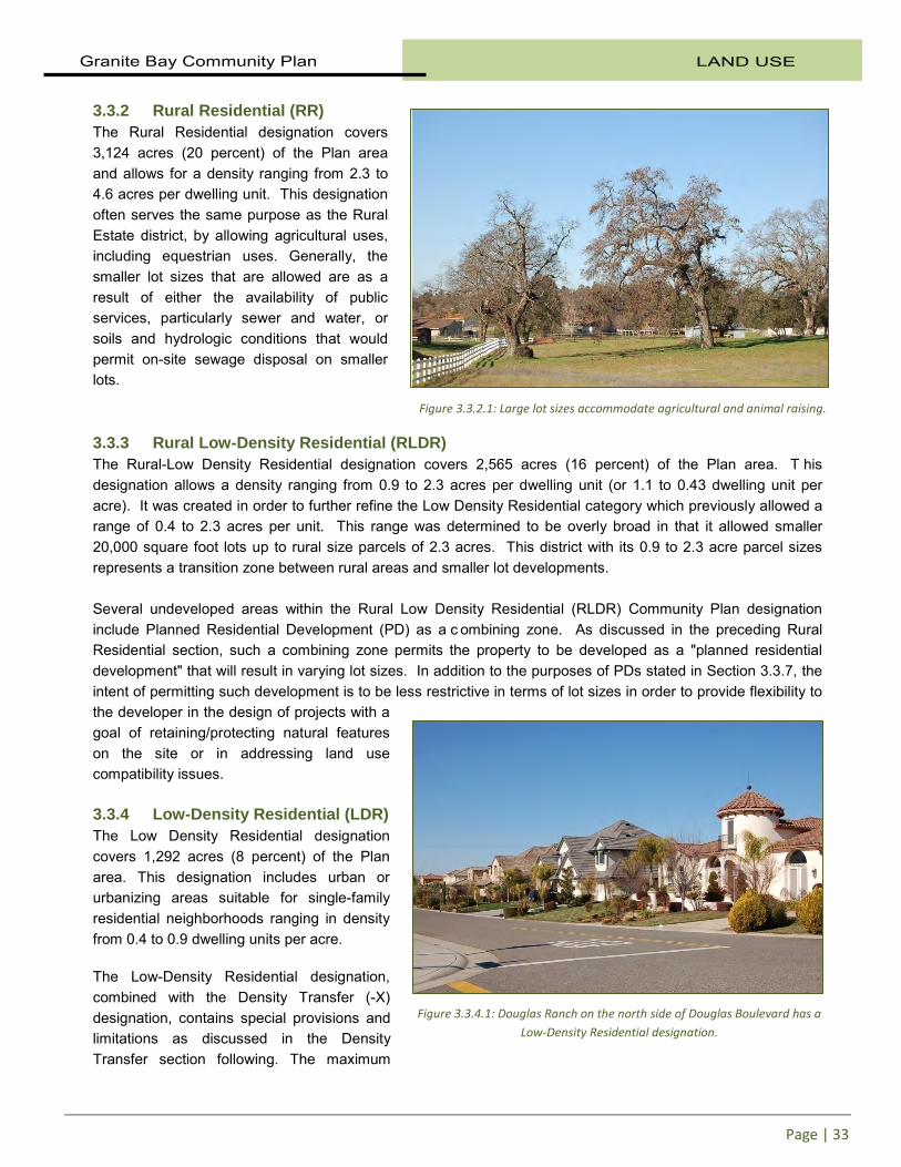
3.3.2 Rural Residential (RR) The Rural Residential designation covers 3,124 acres (20 percent) of the Plan area and allows for a density ranging from 2.3 to 4.6 acres per dwelling unit. This designation often serves the same purpose as the Rural Estate district, by allowing agricultural uses, including equestrian uses. Generally, the smaller lot sizes that are allowed are as a result of either the availability of public services, particularly sewer and water, or soils and hydrologic conditions that would permit on-site sewage disposal on smaller lots. 3.3.3 Rural Low-Density Residential (RLDR) The Rural-Low Density Residential designation covers 2,565 acres (16 percent) of the Plan area. T his designation allows a density ranging from 0.9 to 2.3 acres per dwelling unit (or 1.1 to 0.43 dwelling unit per acre). It was created in order to further refine the Low Density Residential category which previously allowed a range of 0.4 to 2.3 acres per unit. This range was determined to be overly broad in that it allowed smaller 20,000 square foot lots up to rural size parcels of 2.3 acres. This district with its 0.9 to 2.3 acre parcel sizes represents a transition zone between rural areas and smaller lot developments. Several undeveloped areas within the Rural Low Density Residential (RLDR) Community Plan designation include Planned Residential Development (PD) as a c ombining zone. As discussed in the preceding Rural Residential section, such a combining zone permits the property to be developed as a "planned residential development" that will result in varying lot sizes. In addition to the purposes of PDs stated in Section 3.3.7, the intent of permitting such development is to be less restrictive in terms of lot sizes in order to provide flexibility to the developer in the design of projects with a goal of retaining/protecting natural features on the site or in addressing land use compatibility issues. 3.3.4 Low-Density Residential (LDR) The Low Density Residential designation covers 1,292 acres (8 percent) of the Plan area. This designation includes urban or urbanizing areas suitable for single-family residential neighborhoods ranging in density from 0.4 to 0.9 dwelling units per acre. The Low-Density Residential designation, combined with the Density Transfer (-X) designation, contains special provisions and limitations as discussed in the Density Transfer section following. The maximum
Figure 3.3.2.1: Large lot sizes accommodate agricultural and animal raising.
Figure 3.3.4.1: Douglas Ranch on the north side of Douglas Boulevard has a Low-Density Residential designation.
LAND USE Granite Bay Community Plan
Page | 34
potential allowed by the LDR designation in these areas can only be realized by the transfer of density from other parcels in the Plan area (see Section 3.3.12). 3.3.5 Medium-Density Residential (MDR) The Medium Density Residential designation covers 400 acres (3 percent) of the Plan area. This designation is applied to urbanized areas and single-family residential neighborhoods where some lower-density multifamily residential development may be appropriate. Residential density ranges from 2 to 4 dwelling units per acre. 3.3.6 High-Density Residential (HDR) The High Density Residential designation covers 64 acres (less than 1 percent) of the Plan area. This designation allows for residential neighborhoods to have grouped or clustered single-family dwellings, duplexes, apartments, and other multifamily attached dwellings such as condominiums, with a density ranging from 4 t o 10 dwelling units per acre. 3.3.7 Planned Residential Developments (PD) Planned Residential Developments permit greater flexibility and, consequently, more creative and imaginative designs for the development of residential areas than generally is possible under conventional zoning or subdivision regulations. These regulations are intended to promote more economical and efficient use of the land while providing a harmonious variety, type, design and layout of dwellings. Planned Residential Developments are encouraged in selected areas for the following purposes:
1. Preservation of natural resources/features (e.g., creeks, riparian areas, woodlands, vistas, etc.);
2. Providing varying lot sizes where adjoining properties provide greater or lesser densities, in an effort to maintain land use compatibility where a need to have a transition zone exists; and to a lesser degree,
3. Increasing the opportunities for both active and passive recreational facilities such as nature trails, golf courses, or neighborhood parks to meet the needs of residents of the project and/or the general public.
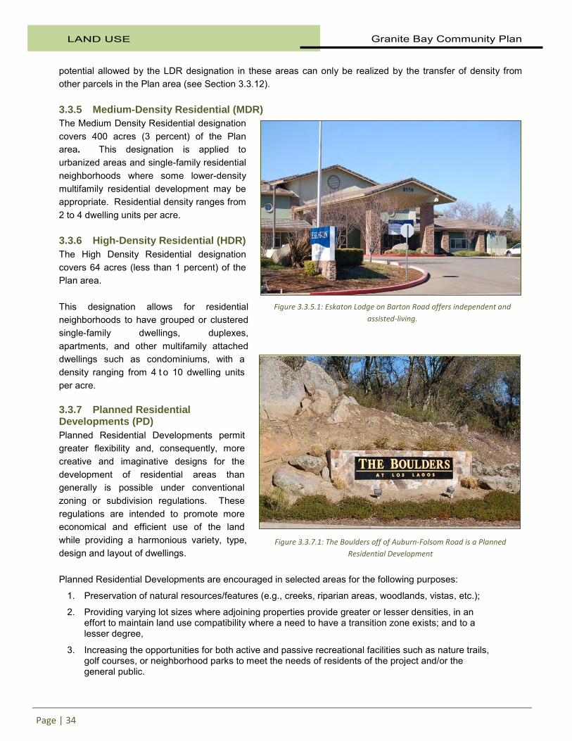
Figure 3.3.5.1: Eskaton Lodge on Barton Road offers independent and assisted-living.
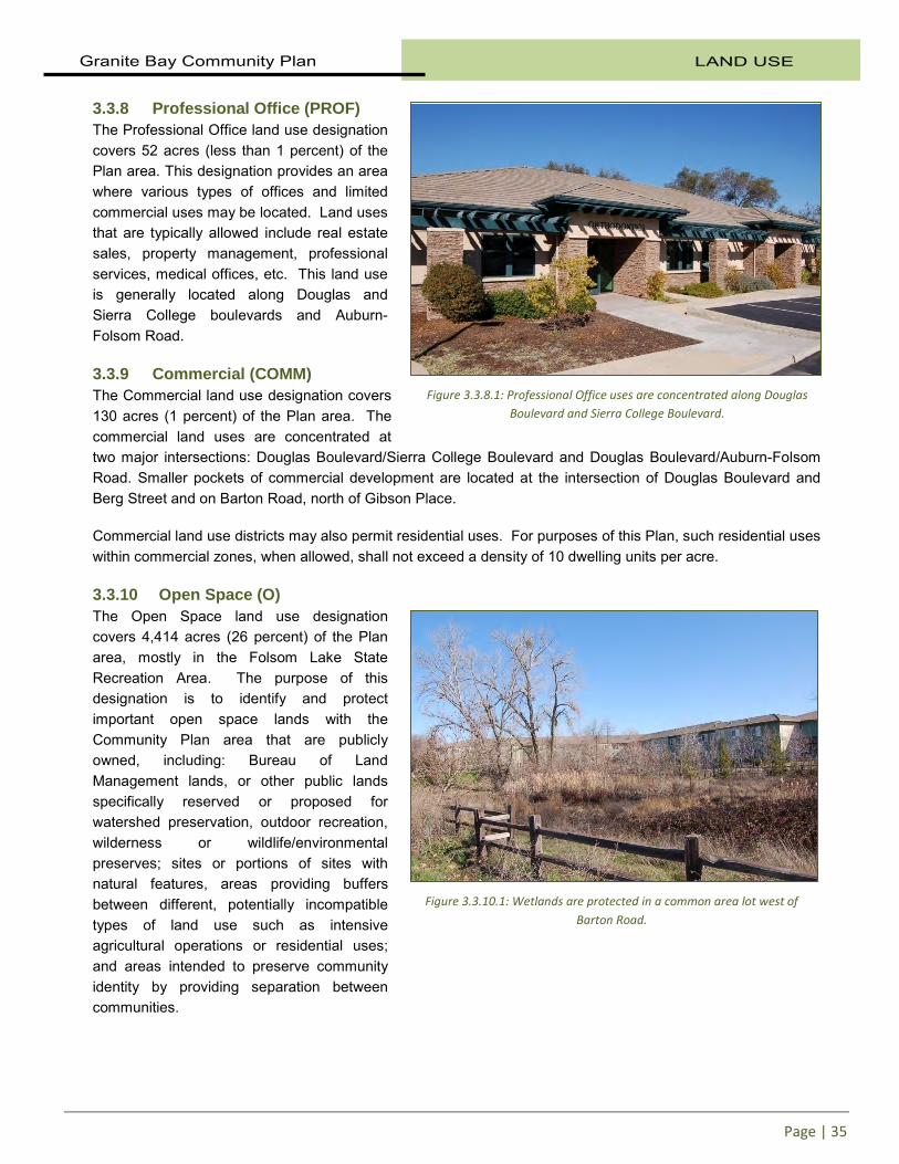
Figure 3.3.7.1: The Boulders off of Auburn-Folsom Road is a Planned Residential Development
Granite Bay Community Plan LAND USE
Page | 35
3.3.8 Professional Office (PROF) The Professional Office land use designation covers 52 acres (less than 1 percent) of the Plan area. This designation provides an area where various types of offices and limited commercial uses may be located. Land uses that are typically allowed include real estate sales, property management, professional services, medical offices, etc. This land use is generally located along Douglas and Sierra College boulevards and Auburn-Folsom Road. 3.3.9 Commercial (COMM) The Commercial land use designation covers 130 acres (1 percent) of the Plan area. The commercial land uses are concentrated at two major intersections: Douglas Boulevard/Sierra College Boulevard and Douglas Boulevard/Auburn-Folsom Road. Smaller pockets of commercial development are located at the intersection of Douglas Boulevard and Berg Street and on Barton Road, north of Gibson Place. Commercial land use districts may also permit residential uses. For purposes of this Plan, such residential uses within commercial zones, when allowed, shall not exceed a density of 10 dwelling units per acre. 3.3.10 Open Space (O) The Open Space land use designation covers 4,414 acres (26 percent) of the Plan area, mostly in the Folsom Lake State Recreation Area. The purpose of this designation is to identify and protect important open space lands with the Community Plan area that are publicly owned, including: Bureau of Land Management lands, or other public lands specifically reserved or proposed for watershed preservation, outdoor recreation, wilderness or wildlife/environmental preserves; sites or portions of sites with natural features, areas providing buffers between different, potentially incompatible types of land use such as intensive agricultural operations or residential uses; and areas intended to preserve community identity by providing separation between communities.
Figure 3.3.8.1: Professional Office uses are concentrated along Douglas Boulevard and Sierra College Boulevard.
Figure 3.3.10.1: Wetlands are protected in a common area lot west of Barton Road.

LAND USE Granite Bay Community Plan
Page | 36
Open spaces and parks are scattered throughout the Plan area and along the shores of Folsom Lake. Open space facilities in the Plan area include:
• Folsom Lake State Recreation Area
• County parks (i.e., Miner’s Ravine Nature Reserve and Granite Bay Community Park
• School facilities
• Private facilities
3.3.11 Agricultural Uses (F) Agricultural lands, although limited, are located in the Plan area, with the largest concentrations in its northern portion. There are no specific areas designated for agriculture by the Community Plan. However, as discussed above, the Rural Estate (RE) and Rural Residential (RR) land use designations allow for very low density residential uses that could also support agricultural land uses. Although the majority of agricultural land in the plan area is classified as Grazing Land by the California Department of Conservation, there are smaller areas designated as Prime Farmland, Farmland of Statewide Importance, and Farmland of Local Importance. 3.3.12 Density Transfer (-X) As a matter of policy, the Plan incorporates and authorizes a Density Transfer program affecting a limited number of parcels within the Plan area. The intent is to create a "mechanism which can assist in implementing the goals and policies of the Plan relative to the maintenance of a s ignificant open space buffer along the south side of Douglas Boulevard. The Program also recognizes the existence of several small lots along Douglas Boulevard. In all cases these parcels are zoned Residential-Agricultural with a required 2.3 acre minimum parcel size, and are therefore currently non-conforming sites. These parcels have been designated as Density Transfer parcels. Participation in this program is voluntary and it is created here as another form of incentive to help implement the goals of the Plan. Parcels from which density can be transferred are identified on the Community Plan map as Low-Density Residential, Density Transfer LDR-X. Parcels which have the ability to receive density (density receptor parcels) are designated on the Plan map with a # symbol. The Low-Density Residential designation and permitted density implied by this designation (2.5 du/acre) can only be utilized through participation in this program. (This is assured through the precise zoning of the property as Residential-Agricultural with a 2.3 acre minimum lot size [RA-100]).
Figure 3.3.11.1: Vineyards and farmland contribute to the rural character of much of Granite Bay.

Granite Bay Community Plan LAND USE
Page | 37
Additional Density Receptor Parcels may be permitted however, and the approval of participation in this program will be subject to the following requirements:
a) Owners of both Transfer and Receptor parcels must agree to participate;
b) Transferred density can only come from those parcels identified in the Land Use Diagram;
c) After adding transferred density to the Receptor Parcel it must not increase the otherwise allowed density by more than 20 percent;
d) The County must approve the proposed design which includes the added density;
e) The project must transfer all density from an individual Density Transfer parcel and ensure the retention of that parcel as open space through the recordation of an open space easement, or similar document to which the County is a party;
f) The Conditional Use Permit process shall be the formal mechanism to be used to request approval of such a transfer and designation of additional Density Receptor Parcels not designated on the Land Use Diagram; and,
g) Subject to all of the requirements stated above, projects utilizing a density transfer, otherwise found to be acceptable by the County, shall be found to be consistent with the Community Plan and zoning density limitations. It is recognized that the density limitations expressed by the Community Plan designation and precise zoning can be exceeded on the parcels indicated and still be considered consistent with the Plan and zoning where a project is utilizing this density transfer opportunity.
From 1989 through 2011, two projects have utilized the density transfer provisions. Silverwood, off Wellington Way north of E. Roseville Parkway, received two units from parcel 048-083-001. Residences of Granite Bay at the northwest corner of E. Roseville Parkway and Barton Road received three units from parcel 048-083-023.
3.3.13 Opportunity Areas Granite Bay lacks a vibrant central area with a strong image and character which functions as the heart of the community. However, commercial sites along the Douglas Boulevard and Auburn-Folsom Road corridors may provide an opportunity to create such a c enter if redeveloped with a range of housing, commercial and/or employment uses. Aging commercial sites that are redeveloped would be expected to provide opportunities that foster incidental social activity and interaction. The suggestions in this section could be implemented if mixed-use districts are proposed and adopted in a future Community Plan amendment by the Board of Supervisors. The mixed-use “Opportunity Areas” are envisioned as a location for civic, cultural and entertainment facilities as well as residential, commercial, retail and/or employment uses. The County would work with developers and the local community to redevelop future-designated sites within the Douglas and Auburn-Folsom corridors to promote more pedestrian-friendly commercial areas, provide needed local serving businesses, and t ake advantage of possibilities for mixed-use development. D esignation of Opportunity Areas would promote redevelopment of commercial areas for a mix of uses that positively contribute to the community’s character and sense of place. Private development that ensures that services continue to meet the daily needs of the community, including groceries, personal services, and day care is envisioned.
LAND USE Granite Bay Community Plan
Page | 38
Mixed-use development refers to development with integrated uses either horizontally or vertically or a combination of both. Mixed-use development provides variety and richness to community life and can be particularly effective in supporting focal points and gateways. Two subcategories are proposed for future consideration- one permitting mixed-uses including commercial space and one permitting a mix of residential housing types. Mixed-Use Opportunity Area The identified potential sites are at the corner of Douglas and Sierra College Boulevard, Douglas at Berg Street, east side of Auburn-Folsom Road south of Fuller Drive, and the corner of Douglas and Auburn-Folsom Road. The designation would provide for residential on the same site or in the same building as commercial, office, institutional and/or public uses. These developments allow efficient use of existing resources and infrastructure. At these locations, mixed-use development would be encouraged to provide an increased level of activity and reinforce their visual and functional prominence. A t a more local level, mixed uses contribute to promoting pedestrian activity and interaction for extended periods of time. Diversity of uses is encouraged to promote the potential for individuals to live, work, eat, shop and congregate within the community and potentially on the same parcel. Mixed-use development would be subject to a high standard of design to support their landmark image and functions as appropriate, promote transit oriented development if available, create a favorable pedestrian realm, and ensure compatibility of the various uses within and adjoining the development. In addition to the policies for the uses, special attention shall be g iven to contextual design and planning through a combination of careful site layout, built form, street and streetscape design, as well as on-site amenities. If a strategy of implementing mixed-use opportunity areas is pursued, consideration should be given to instituting zoning incentives to make these types of projects feasible while requiring a community benefit (i.e. providing a civic gathering space). S uch incentives may include allowing higher density development than currently permitted within the Plan area. Mixed-use development is more expensive than conventional development and allowing more than 10 units per acre may assist in the feasibility of such projects. Consideration should also be given to allowing slightly taller buildings on these sites than normally would be permitted so that uses may be stacked on t op of each other. Relaxation of parking standards may also be considered. Mixed-Residential Opportunity Area The one suggested Mixed-Residential location consists of vacant parcels on the south side of Douglas immediately east of the Greyhawk subdivision and at the corner of Berg Road and Douglas. Other parcels and locations could also be considered for such designation however. Housing on a Mixed-Residential Opportunity site may come in a variety of forms. Appropriate residential uses include apartments, lofts, townhomes, live/work units, condominiums, and clustered units.
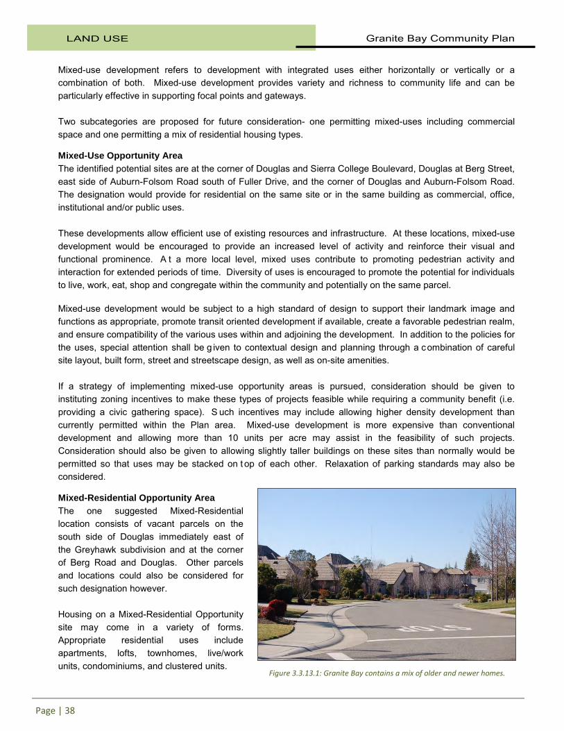
Figure 3.3.13.1: Granite Bay contains a mix of older and newer homes.

Granite Bay Community Plan LAND USE
Page | 39
3.4 EXISTING ZONING The Plan area currently contains nine base zoning districts as outlined in the County Zoning Ordinance. I n addition to the base zone districts that can be found in the Plan area, there are also several combining districts. Table 3.4.1 below identifies the existing zoning districts in the Plan area and provides their total acreages.
Table 3.4.1 Acreage by Zoning District
Zoning District Acreage Percentage of
Plan area
Neighborhood Commercial (C1) 39 0.2% General Commercial (C2) 12 0.1% Commercial Planned Development (CPD) 84 0.5% Farm (F) 226 1.4% Open Space (O) 4,420 27.9% Office and Professional (OP) 53 0.3% Residential-Agricultural (RA) 6,608 41.7% Residential-Multifamily (RM) 63 0.4% Residential Single-Family (RS - No Combining) 101 0.6% Residential-Single-Family Combining Agricultural (RS-AG) 3,271 20.7% Residential Single-Family (RS - Combining 7,000 sf to 20 acre min) 955 6.0%
Source: Placer County GIS Database, 2011
Figure 3.4.1: Otow Orchard on Eureka Road has been a Granite Bay mainstay for generations.

LAND USE Granite Bay Community Plan
Page | 40
The table below indicates the Zoning Districts that directly correspond to each of the current Community Plan designations.
Table 3.4.2
Zoning Compatibility
Community Plan Designations Compatible Zone Districts COMMERCIAL General Commercial, Heavy Commercial, Commercial
Planned Development, Office Professional, Residential Multi-Family
PROFESSIONAL OFFICES Office-Professional HIGH DENSITY RESIDENTIAL Residential Multi-Family, Residential Single-Family, Open
Space MEDIUM DENSITY RESIDENTIAL Residential Single-Family, Open Space LOW DENSITY RESIDENTIAL Residential Single-Family, Residential Agricultural, Farm
and Open Space RURAL LOW DENSITY RESIDENTIAL Residential Single-Family, Residential Agricultural, Farm
and Open Space RURAL RESIDENTIAL Residential Single-Family, Residential Agricultural, Farm
and Open Space RURAL ESTATE Residential Single-Family, Residential Agricultural, Farm
and Open Space OPEN SPACE Open Space
GENERAL PLAN DESIGNATIONS USED IN COMBINATION WITH ANY OF THE ABOVE Density Limitation -Planned Residential Development (-PD combining zone)
-Density Limitation (-DL combining zone) including a number which expresses a maximum permitted number of dwelling units per acre, i.e. DL-5 of PD 1.1. (The number of du/acre cannot exceed that permitted by the General Plan designation.)
Density Transfer Residential Agricultural - 2.3 acre minimum
*Note: The maximum residential density permitted in the Granite Bay Plan area is 10 dwelling units per acre.
Figure 3.4.2: Quail Oaks Lane near Douglas Boulevard.