6 biological resources - placer county, california
TRANSCRIPT

Placer County Village at Squaw Valley Specific Plan EIR 6-1
BIOLOGICAL RESOURCES 6
This chapter evaluates the terrestrial and aquatic resources known or with potential to occur within the project site. Biological resources include common plant communities and habitat types, wetlands and other sensitive communities, and special-status plant and animal species. This chapter describes potential impacts to those resources as a result of project implementation, and identifies measures recommended to eliminate or reduce potentially significant impacts to less-than-significant levels. The information presented in this analysis is primarily based on the following sources.
Squaw Valley Village Biological Resources Assessment (Salix Consulting 2012a).
Squaw Valley East, Lot 4 Biological and Wetland Constraints (Salix Consulting 2012b).
Wetland Delineation for the ±107-Acre Squaw Valley Village (Salix Consulting 2012c).
Special Status Plant Survey Report for the ±46-Acre Squaw Valley Village Core Study Area (Salix Consulting 2013a).
Biological Resources Assessment and Rare Plant Survey for the ±8.8-Acre Squaw Valley East Lot 4 Study Area (Salix Consulting 2013b).
Biological Resource Report and Rare Plant Survey for the 5-Acre Squaw Valley Poulsen Parcel Northeast Study Area (Salix Consulting 2013c).
Wetland Delineation for the ±8.8-Acre Squaw Valley East Lot 4 Study Area (Salix Consulting 2014a).
Biological Resources Assessment and Rare Plant Survey for the ±10.5-Acre Squaw Valley Carville Water Tank Parcel (Salix Consulting 2014b).
Wetland Delineation for the ±10.5-Acre Squaw Valley Carville Water Tank Parcel (Salix Consulting 2014c).
Wetland Delineation for the 5-Acre Squaw Valley Poulsen Parcel Northeast Study Area (Salix Consulting 2014d).
Biological Resources and Wetlands Constraints Analysis for the 2.2-Mile Squaw Valley Sewer Line Study Corridor (Salix Consulting 2014e).
Squaw Valley Ski Corporation Capital Projects 2011 - Village Tree Survey (Under the Trees Forestry and Environmental Services 2011).
Squaw Valley Ski Corporation 2012 Capital Projects - Village Additional Tree Survey (Under the Trees Forestry and Environmental Services 2012a).
Squaw Valley Ski Corporation 2012 Capital Projects – Parking Lot#4 Tree Survey (Under the Trees Forestry and Environmental Services 2012b).
Technical Memorandum: An Assessment of Squaw Creek Fisheries and Discussion of Potential Impacts of the Squaw Valley Village Project (GANDA 2012).
Potential Impacts of Increased Groundwater Pumping on Fisheries, Village at Squaw Valley Specific Plan Project (GANDA 2014).

Biological Resources Ascent Environmental
Placer County 6-2 Village at Squaw Valley Specific Plan EIR
Water Demands Analysis for the Village at Squaw Valley SB 610, Water Supply Assessment (Farr West Engineering 2014).
Village at Squaw Valley Specific Plan Water Supply Assessment (Farr West Engineering et al. 2014; included as Appendix C).
Squaw Valley Water Quality Investigation Report, Drainage Area of Squaw Creek at the Confluence of the Main Stem and the Olympic Channel (Balance Hydrologics 2013).
Design Basis Report: Squaw Creek Restoration, Squaw Valley Specific Plan, Placer County, California (Balance Hydrologics 2014a).
Squaw Creek Restoration Goals, Objectives, and Anticipated Benefits, Squaw Valley Specific Plan, Placer County, California. Letter Memorandum to Adreinne Graham from David Shaw (Balance Hydrologics 2014b).
Draft Master Drainage Study, Village at Squaw Valley Specific Plan (MacKay & Somps 2012).
Updated Drainage Study, Village at Squaw Valley. Technical Memorandum #3 (MacKay & Somps 2014a).
Model Simulated Squaw Creek Flow and Groundwater Elevation Data (Todd Groundwater 2014).
ENVIRONMENTAL SETTING 6.1
6.1.1 Regional Setting
The project area is located in the central Sierra Nevada within the 4,700‐acre Squaw Valley (also known as Olympic Valley) in northeastern Placer County (see Exhibit 3-1 in Chapter 3, “Project Description”). The Sierra Nevada is approximately 400 miles long and consists of a diverse array of ecological communities across an elevational gradient of 1,000 feet to over 14,000 feet; communities distributed across this gradient range from oak woodland in the lower elevations to subalpine conifer and alpine communities at the highest elevations. The west and east sides of the Sierra Nevada are vastly different due to the rain shadow effect, which causes the eastern Sierra to receive less precipitation and support biological communities adapted to more xeric conditions. The Olympic Valley is located near the transition between the west and east sides of the Sierra Nevada, at the mid-elevation zone in mixed conifer forest.
6.1.2 Local Setting
The project area includes the project site and the fairly confined general vicinity surrounding the project site, but not the entire Olympic Valley. The project area includes Squaw Valley Ski Resort, Squaw Valley Village with associated commercial development, and neighboring housing and open space. It occurs just east of the Pacific Crest and is bounded to the north, west, and south by moderately-steep, rocky slopes that generally rise about 2,000 feet to the north and south and almost 3,000 feet to the west.
The Village area is generally bounded by Squaw Valley Road and residential development to the north; ski lifts and related ski operations and commercial uses to the south and west; lodging, single‐family residences, and undisturbed areas to the west; and the meadow and golf course to the east. It is located and surrounded on almost all sides by private lands, except on the north where it is bounded by the Tahoe National Forest. The project area also encompasses the meadow reach of Squaw Creek, Squaw Valley Road, the East Parcel, and a portion of the Truckee River. The East Parcel is located approximately 1.3 miles east

Ascent Environmental Biological Resources
Placer County Village at Squaw Valley Specific Plan EIR 6-3
of the main Village area and 0.3 mile west of the intersection of State Route (SR) 89 and Squaw Valley Road, across the street from the Squaw Valley Public Service District (SVPSD) offices and fire station (see Exhibits 3-2 and 3-3 in Chapter 3, “Project Description”). The East Parcel is bounded by Squaw Valley Road to the south, Squaw Creek and existing residences to the north, existing residences to the west, and undisturbed areas to the east.
SITE LOCATION AND DESCRIPTION The project site encompasses approximately 121 acres (85 acres [Village], 9 acres [East Parcel], 27 [Utilities and Other Facilities]) and includes the Specific Plan area and other proposed facilities such as utility lines (e.g., water, stormwater, sewer) and a water tank. It includes the Village area, the East Parcel, and those areas proposed for utility construction. Additional areas just outside the Village and East Parcel boundaries were included in the project site to encompass construction impacts from supporting facilities associated with development of the Specific Plan. The major extensions from the plan area boundary for utilities include: the sewer line corridor that follows Squaw Creek Road into the East Parcel and ending just past SR 89 and the Truckee River; and the additional water tank and associated utility lines just north of the Village Neighborhood areas.
Most of the project site is developed and disturbed, with some undeveloped forest and meadow land. Approximately 400 feet of elevation change occurs from the highest point on the site (the water tank) to the lowest point on the site (portions of Squaw Creek), with elevations ranging between approximately 6,075 and 6,460 feet above mean sea level. Olympic Valley is surrounded on almost all sides by mixed conifer forest and rocky granite slopes. The mixed conifer forest within the project site provides habitat for forest associated species. A large meadow complex with swaths of willows with other riparian and wetland obligates extends from the golf course east of the ski area toward SR 89. This meadow area can provide high-quality forage and cover for many wildlife species. Squaw Creek, the Olympic Channel, and other small water courses and meadow habitats are also located within the project site and are mapped in Exhibits 6-1 and 6-2. All of these small riparian and wetland areas can provide important foraging habitat, cover, and water for wildlife. These sites likely attract wildlife to the valley and were probably well utilized historically by species within the area.
PHYSICAL FEATURES Regional geologic maps indicate that project site is underlain by various age volcanic rocks, granitic rocks, and alluvial and glacial deposits (Salix Consulting 2012a). The project site is located within a valley surrounded by high mountain peaks on three sides. The area slopes gently from west to east while also draining into Squaw Creek. Squaw Creek flows primarily in an easterly direction through the project area and ultimately reaches the Truckee River at the mouth of the valley. Its main tributary is intermittent and originates from the southwest near Squaw Peak. Squaw Creek flows in an engineered channel through much of the main Village area into the meadow area to the east. Other tributaries are ephemeral or intermittent and flow for a short time during the year.
6.1.3 Biological Communities
The following descriptions of biological communities within the project site are taken from the references listed above, supplemented by additional information collected during a site visit conducted by an Ascent Environmental biologist in August 2013. Table 6-1 shows the acreages of the land cover types and wetlands and waters of United States within the project site and potentially affected by the Specific Plan. Exhibits 6-1 and 6-2 show the common and sensitive land cover types, including wetlands and other waters of the United States, within the project site. Percentage of land cover that would be affected by different land use categories (e.g., parcels with Village Commercial – Core zoning would have different biological resources impacts than those with Village – Conservation Preserve zoning) was estimated on a lot by lot basis (see

Biological Resources Ascent Environmental
Placer County 6-4 Village at Squaw Valley Specific Plan EIR
Exhibits 3-4, 6-1, and 6-2 for land uses/zoning and lot boundaries). The impact assumptions for each lot are described in Appendix E.
COMMON HABITATS
Developed Developed portions of the project site include approximately 53 acres of existing buildings, structures, water tanks, and parking lots associated with the Squaw Valley Ski Resort area. These areas are covered with either permanent structures or pavement associated with parking and staging areas. Most of the project site is designated as developed. Small islands of natural vegetation occur between structures and buildings, and within parking areas. Common trees observed within these islands of vegetation include aspen (Populus tremuloides), lodgepole pine (Pinus contorta), and black cottonwood (Populus balsalmifera trichocarpa), Annual herbaceous species include Spanish lotus (Lotus purshianus), cheatgrass (Bromus tectorum), western burnett (Poterium annuum), and orchardgrass (Dactylis glomerata). Various native shrubs and herbaceous vegetation, including Nevada buckwheat (Eriogonum umbellatum nevadense), rabbitbrush (Ericameria nauseosa), mule ears (Wyethia mollis), and mountain phacelia (Phacelia hastata) also occur on islands of habitat throughout developed portions of the site.
Disturbed Disturbed portions of the project site consist of approximately 21 acres that have experienced substantial disturbance as a result of previous development activities or on-going ski resort operations. These areas include portions of the East Parcel, portions of the Village Core Area, and vegetation by the proposed water tank site. Some transition areas between developed areas of the site and areas of natural vegetation have been designated as disturbed for the purposes of this study. Disturbed portions of the site include areas located adjacent to roadways and parking lots, and areas where vegetation has been removed or significantly disturbed. Areas located beneath chair lifts are also considered disturbed habitats due to the ongoing maintenance and vegetation clearing associated with ski resort operations. Small pockets of natural vegetation may occur within larger disturbed areas, while some disturbed areas are completely devoid of vegetation. Larger disturbed areas support primarily both native and weedy annual species. Characteristic plants occurring where vegetation is present include cheatgrass (Bromus tectorum), pineapple weed (Matricaria discoidea), pussypaws (Calyptridium monospermum), white sweetclover (Melilotus alba), chicory (Cichorium intylous), slender wheatgrass (Elymus trachycaulus), blue flax (Linum lewisii) mountain tarweed (Madia glomerata), Kentucky bluegrass (Poa pratensis), common sheep sorrel (Rumex acetosella) and yarrow (Achillea millefolium). Areas located beneath chair lifts may support some natural vegetation, but the cover is sparse due to ongoing vegetation management operations. This vegetation type also includes landscaped vegetation associated with buildings such as ornamental trees, shrubs, herbs, and turf mixed with native and non-native conifer species.
Meadow (Dry) Approximately 6 acres of non-jurisdictional meadows (i.e., not classified as wetlands or waters of the U.S. under Section 404 of the Clean Water Act) are located adjacent to Squaw Creek, Squaw Creek meadows, the Olympic Channel within the Village area, the parcel just east of the Far East Road bridge, and the Squaw Valley Road sewer line corridor. These meadows are variable in terms of wetness and vegetation is generally dominated by grasses and forbs with non-grass species such as sedges, rushes, and bentgrasses in some areas. They have seasonally saturated soils and are usually associated with an adjacent riparian or scrub community, seep, or waterway. Vegetation is dominated by grasses including quakegrass (Elytrigia repens), bluegrass (Poa bolanderia), meadow barley (Hordeum brachyantherum), blue wildrye (Elymus glaucus), gayophytum (Gayophytum diffusum), and non-grass species including Mexican rush (Juncus mexicanus), Nebraska sedge (Carex nebrascensis), pale dandelion (Agoseris glauca), elk thistle (Cirsium scariosum), Oregon checker mallow (Sidalcea oregano), Douglas’ knotweed (Polygonum douglasii), and sheep sorrel (Rumex acetosella). Scattered willows (Salix spp.) also occur within some of these meadow areas. This land cover type is considered non-jurisdictional according to wetland delineation reports for the area.

Ascent Environmental Biological Resources
Placer County Village at Squaw Valley Specific Plan EIR 6-5
Exhibit 6-1 Land Cover Map 1 of 2


Ascent Environmental Biological Resources
Placer County Village at Squaw Valley Specific Plan EIR 6-7
Exhibit 6-2 Land Cover Map 2 of 2


Ascent Environmental Biological Resources
Placer County Village at Squaw Valley Specific Plan EIR 6-9
Table 6-1 Acres of Land Cover on the Project Site
Land Cover Total Acres on Project Site
Impact Acres Percentage of Land Cover On Project Site Affected Main Village East Parcel Utilities and
Other Facilities Total
Common Habitats
Developed 53.41 40.46 0.03 11.71 52.20 98%
Disturbed 20.96 7.5 3.67 7.93 19.10 91%
Meadow (Dry)1 5.46 3.02 1.77 4.79 88%
Mixed Conifer Forest 25.72 6.45 2.69 2.97 12.11 47%
Sagebrush Scrub 2.16 0.85 1.06 1.91 88%
Sensitive Habitats (includes potential jurisdictional wetlands and other waters of the United States)2
Alderleaf Coffeeberry Scrub 0.10 0.05 0.05 50%
Detention Pond 0.10 0.06 0.04 0.10 100%
Ephemeral Stream 0.01 0.01 0.01 100%
Intermittent Stream 5.32 1.96 1.96 37%
Perennial Stream 0.43 0.05 0.16 0.21 49%
Riparian2 4.16 1.87 0.03 1.90 46%
Seasonal Wetland 0.13 0.05 0.06 0.11 85%
Seasonal Wetland/Willow Scrub 0.30 0.26 0.04 0.30 100%
Seep 0.05 0.01 0.01 0.02 40%
Seep/Alderleaf Coffeeberry Scrub 0.21 0.05 0.05 24%
Seep/Willow Alder Scrub 0.01 0.01 0.01 100%
Wet Meadow 1.01 0.33 0.61 0.94 93%
Wet Meadow/Willow Scrub 0.03 0.03 0.03 100%
Wetland Swale 0.51 0.4 0.05 0.03 0.48 94%
Wetland Swale/Willow Alder Scrub 0.06 0.06 0.06 100%
Willow Alder Scrub 0.06 0.01 0.05 0.06 100%
Willow Scrub 0.05 0.01 0.04 0.05 100%
Grand Total 120.25 62.97 6.87 26.61 96.45 80% For additional information see Lot Impact Assumptions and Acres in Appendix E.
1 Meadow (dry) is not “jurisdictional” per Section 404 of the Clean Water Act based on Salix Consulting Biological and wetlands constraints analyses. Therefore, meadow is considered a common land cover. This description is based on Salix Consulting Biological Analyses. The land cover meadow areas were separated from the jurisdictional meadows that were identified in their wetland delineation or constraints analyses. See text description below under Riparian.
2 Riparian habitat is included in all perennial stream acres (0.43 acres) located in Lot 4 and along the Truckee River. Some intermittent stream acres also include riparian habitat, particularly within the Squaw Creek restoration corridor (Lot 23). Riparian habitat was not delineated separate from Perennial or Intermittent Stream in these areas in biological resource reports (Salix Consulting 2012a, 2012b, 2012c) and therefore some acreage within these habitat types would include riparian areas.
Sources: Salix Consulting 2012a, 2012b, 2012c, 2013a, 2013b, 2014a, 2014b, 2014c, 2014d; Squaw Valley Real Estate, LLC 2015
Mixed Conifer Forest Approximately 26 acres of the project site are identified as mixed conifer forest and occur throughout the project site. This community primarily occurs up-slope from the valley floor and out of the developed or disturbed areas. Canopy cover varies from dense to a more open canopy. The denser areas seem to be closer to creeks and meadows; density seems especially high on the East Parcel. In open areas, the

Biological Resources Ascent Environmental
Placer County 6-10 Village at Squaw Valley Specific Plan EIR
understory consists of a variety of shrubs, grasses, and forbs, including bitter cherry (Prunus emarginata), Nevada buckwheat (Eriogonum umbellatum Torrey var. nevadense), antelope bitterbrush (Purshia tridentata), mountain whitethorn (Ceanothus cordulatus), huckleberry oak (Quercus vacciniifolia), big sagebrush (Artemisia tridentata spp. vaseyana), mountain spirea (Spiraea densiflora.), California coffeeberry (Rhamnus californicus), greenleaf manzanita (Arctostaphylus patula), and pinemat manzanita (Arctostaphylos nevadensis). The more common herbaceous species observed in more open forested areas include mountain mule’s ear, bracken fern (Pteridium aquilinum), white-veined wintergreen (Pyrola picta), blue wildrye (Elymus glaucus), and common yarrow. The dominant trees occurring within mixed conifer forest in the project site are lodgepole pine, white fir (Abies concolor), and Jeffrey pine (Pinus jeffreyi). Western juniper (Juniperus occidentalis), mountain hemlock (Tsuga mertensiana), and quaking aspen also occur as part of the tree canopy in scattered locations throughout the site.
Within the forested stands of the project site, there are small drainages and seeps that support patches of riparian scrub vegetation. Areas qualifying as “waters of the United States” that are embedded within conifer forest on the project site, including seeps and drainages, are discussed in further detail in the waters of the U.S. discussion below.
Sagebrush Scrub Approximately 2 acres of sagebrush scrub vegetation can be found within Lots 26 and 27, adjacent to the proposed water tank site, and in the sewer line corridor that runs east of the Village. Mountain big sagebrush (Artemisia tridentata ssp. vaseyana) shrubs dominate this vegetation type with other soft-woody shrubs including rubber rabbitbrush (Chrysothamnus viscidiflorus) and bitterbrush (Purshia tridentata). Herbaceous species interspersed among the shrubs include slender wheatgrass, cheatgrass, bluegrass (Poa bolanderi), and mountain mule’s ears.
SENSITIVE HABITATS
Alderleaf Coffeeberry Scrub The project site includes 0.10 acre of alderleaf coffeeberry scrub. This scrub habitat is located within the East Parcel and on the sewer line corridor near the western edge of the project site. This vegetation is dominated by alderleaf coffeeberry (Rhamnus alnifolia) and within Olympic Valley, is generally associated with groundwater discharge (seeps). Similar to willow scrub (described below) it also contains willow (Salix exigua), shining willow, Pacific willow (Salix lasiandra), Hood’s sedge (Carex hoodi), tall mannagrass (Glyceria elata), and musk monkeyflower (Mimulus moschatus). There is another 0.21 acre of alderleaf coffeeberry scrub habitat associated with a seep that is described under “Seep,” below.
Detention Pond Two small, man-made detention ponds (0.10 acre) are located within the project site. One is located north of Squaw Creek in the western section of the Village Core area to provide water storage. The other is located south of the Village Core area adjacent to a ski run. Depending on the yearly precipitation and season, these ponds may or may not contain water. No wetland vegetation is associated with the detention pond within the Village or adjacent to the ski run. Both ponds may be considered jurisdictional by the state.
Intermittent Stream Intermittent streams are seasonal streams, typically flowing through the wet season and for several months after. Several intermittent streams occur within the project site (5.32 acres) including the western portions of Squaw Creek, some of its tributaries, and unnamed streams in the water tank parcel and sewer line corridor. Intermittent streams within the project site are potentially jurisdictional waters of the United States.
Squaw Creek originates from rocky slopes located west of the Squaw Valley resort area, just east of the Pacific Crest. The stream flows primarily in an easterly direction to the Truckee River. The portion of Squaw Creek that flows through the Village Core area is considered intermittent as there are periods of the year when surface flows cease. There are portions of the stream downstream of the Village Core where both dry

Ascent Environmental Biological Resources
Placer County Village at Squaw Valley Specific Plan EIR 6-11
and wet reaches occur in the dry season. Squaw Creek consists of a moderate-gradient channel with a rocky substrate, consisting of large cobbles and boulders. Deeper pockets of water occur behind boulder clusters within the stream channel. As the creek flows east, the channel widens and the gradient decreases. The stream has been channelized in a trapezoidal channel for much of its length throughout the Village Core area and the substrate in this area consists mostly of small cobbles intermixed with decomposed granite and fine sediment. The north and south branches of Squaw Creek west of the Village Core area are designated as intermittent.
Other intermittent streams in the Village Core area are narrow and rocky and contain upland species including wild rose (Rosa californica), currant (Ribes spp.), mule’s ears, and several grass species. One small, unnamed intermittent stream also occurs in the northwestern portion of the Village Core area. This drainage is likely fed by a spring located in rocky slopes located up-slope and north of the resort area. Upstream the channel is narrow and deeply incised, and forest trees occur directly adjacent to the channel. Minimal riparian vegetation occurs along upstream portions of this drainage. Farther downstream, flow within the channel is intermittent but areas located outside of the channel are moist. Fairly dense willows occur in association with downstream portions of the drainage. Downed woody debris occurs in the channel along much of the length of this drainage. The last intermittent stream mapped in the Village Core area occurs near the eastern boundary near the golf course. This channel is incised and carries flows from the south into Squaw Creek. It supports hydrophytic vegetation and a willow riparian scrub community.
Small intermittent streams are located within the sewer line corridor. These are mostly fed by culverts that drain beneath Squaw Valley Road toward the meadow area to the south.
Within the water tank parcel, one intermittent stream flows along the western section of the parcel and another along the eastern edge. Both flow into storm drains that travel under the developed area and discharges into the North Fork of Squaw Creek. The western stream provides general flows from storm water and snow melt, even into the dry season through groundwater discharge. The drainage supports alder, willow, and aspen with a fairly healthy herbaceous layer such as monkey flower (Mimulus guttatus) and columbine (Aquilegia formosa). Another stream is located in a minor drainage on the eastern section of the parcel. The eastern stream is a minor channel that supports willows and other hydrophytic herbaceous vegetation.
Ephemeral Stream Ephemeral streams are short duration storm channels that have clear bed and bank morphology and a discernible ordinary high water mark. These streams carry water during and shortly after storms but are typically dry between events and therefore do not support hydrophytic vegetation. Small ephemeral streams are located within the sewer line corridor and total 0.01 acre. These are mostly fed by culverts that drain beneath Squaw Valley Road toward the meadow area to the south. Ephemeral streams within the project site are potentially jurisdictional waters of the United States.
Seep Seep communities occur in association with groundwater discharge areas and surface flow that are moist or wet at the ground surface for much of the year. Seeps within the project site are potentially jurisdictional waters of the United States and total about 0.27 acre. Seeps occur in three isolated locations within the northwestern and southeastern portions of the Village Core area, one area in the East Parcel, and one area along the sewer line corridor. One small seep occurs on a south-facing slope just up-slope of the unnamed, perennial drainage in the northwestern portion of the Village Core area. Soils within this habitat have been moist into late fall (Salix Consulting 2011). Vegetation consists of an overstory of mountain dogwood (Cornus sericea), and mountain alder (Alnus incana ssp. tenuifolia), and an understory of wild rose, arrow-leaf groundsel (Senecio triangularis), sedges, and bracken fern. Two other seep areas were identified in the southeastern portion of the Village Core area, on a north-facing hillside beneath a large support pole for the ski lift, and just west of there on the same hillside at the edge of a ski run. Moisture within these seeps appears to be fed seasonally primarily by runoff from snowmelt along the hillside. These seeps are defined as Seep/Willow Alder Scrub land cover in Table 6-1. Vegetation within the seep primarily consists of

Biological Resources Ascent Environmental
Placer County 6-12 Village at Squaw Valley Specific Plan EIR
mountain alder, willows, dogwood, and small black cottonwoods. In the East Parcel, a seep occurs on a low gradient slope that discharges on the eastern portion of the parcel. This seep provides habitat for a dense population of alderleaf coffeberry as well as shining and sandbar willow and is defined in Table 6-1 as land cover Seep/Alderleaf Coffeeberry Scrub. Lastly, a seep occurs within mixed conifer forest habitat to the east of Winding Creek Road along the sewer line corridor.
Perennial Stream Perennial streams, unlike ephemeral or intermittent streams, flow year-round. They exhibit bed-and-bank morphology and include riparian vegetation. A total of 0.43 acre of perennial stream occur within the project site and are potentially jurisdictional waters of the United States. The lower section of Squaw Creek is a perennial stream within the East Parcel and in the eastern section of the sewer line corridor, due in part to the year round discharge of groundwater from Squaw Valley Meadow. The easternmost perennial stream feature in the identified project site boundary is the section of the Truckee River on the most eastern section of the sewer line corridor. Willow and alder line the channel of this stream. Activity in the Truckee River channel consists of replacement of an existing sewer siphon under the river. Replacement of this section of the sewage transmission system is included in SVPSD facility planning and would be implemented by SVPSD whether or not the VSVSP moves forward. The sewer siphon replacement is discussed further in Chapter 13, “Hydrology and Water Quality.”
Riparian The riparian vegetation on the project site (4.16 acres) primarily occurs along Squaw Creek in the Village Core area and the East Parcel, along the sewer line corridor, along intermittent channels in the water tank parcel, and on small tributaries to Squaw Creek located in the northwestern portion of the Village Core area. Riparian vegetation also occurs in scattered locations along various wetland swales and drainages within the site. Where riparian vegetation does occur, it is generally confined to narrow bands along the drainages and is patchy in distribution. Riparian habitat is slightly underrepresented in the acreage calculations as it was not always delineated separately from perennial or intermittent stream in the biological resource reports (Salix Consulting 2012a, 2012b, 2012c). Riparian habitat is included in all of perennial stream acres (0.43 acre) located in Lot 4 and along the sewer line corridor stretching east from the Village. Some intermittent stream acres also include riparian habitat, particularly within the Squaw Creek restoration corridor (Lot 23).
Riparian vegetation occurs as a narrow corridor along much of Squaw Creek due to the presence of parking lots and roads at the top of the embankment in the Village area or the presence of houses and conifer encroachment on the East Parcel. Along the portion of Squaw Creek located upstream and near the western Village boundary, the riparian corridor is more established, due to less historic grading disturbance. Downstream of the Village area boundary, the riparian corridor is generally wider, but still patchy in distribution. A small riparian corridor also occurs within the water tank parcel. Black cottonwood, mountain alder (Alnus incana tenuifolia), and shining willow (Salix lucida) are the most common tree and shrub species that occur in association with the main stem of Squaw Creek. Various understory species present within the narrow riparian corridor of Squaw Creek include common horsetail, common monkeyflower (Mimulus guttatus), stinging nettle (Urtica dioica), mountain butterweed (Senecio intergerrimus), rushes (Juncus sp.), and sedges (Carex spp.). Spotted knapweed (Centaurea maculosa), a noxious weed, was also present along Squaw Creek (Ascent Environmental 2013).
A narrow corridor of riparian scrub also occurs along the small, perennial drainage located in the northwestern portion of the Specific Plan area on the slopes in the Village Neighborhood area. Here, the banks are steep-sided and montane forest vegetation occurs directly adjacent to the channel in some locations. Dominant trees that occur along the small perennial stream include mountain alder, mountain ash (Sorbus californica), dogwood, and willows (Salix sp). Other understory species observed in the limited areas of creek/riparian in the northwestern portion of the site include coffeeberry (Rhamnus californica), corn lily (Veratrum californicum californicum), meadow rue (Thalictrum fendleri), sedge, fireweed (Chamerion angustifolium), hairy willow-herb (Epilobium hirsutum), arrow-leaf groundsel (Senecio triangularis), Oregon grape (Berberis aquifolium aquifolium), and wild rose.

Ascent Environmental Biological Resources
Placer County Village at Squaw Valley Specific Plan EIR 6-13
Seasonal Wetlands Approximately 0.13 acre of seasonal wetland habitat is located in Lot 26, the parcel just east of the Far East Road bridge, and along the sewer line corridor.
Three seasonal wetlands occur beneath the forest canopy in the mixed-conifer habitat within the east parcel (Lot 4) and the associated utilities. Most of the wetlands on the east parcel support sedges and willow (Salix. sp.) species. Lodgepole pine, scattered willows (Salix spp.), tall mannagrass (Glyceria elata), and tufted hairgrass (Deschampsia cespitosa) are also present within these wetlands areas. The landcover type, Seasonal Wetland/Willow Scrub, is included in this seasonal wetlands category (0.30). These habitats may be considered jurisdictional.
The two seasonal wetlands in Lot 26 are dominated by Mexican rush and sedge species. They occur north of the confluence of the Olympic Channel and Squaw Creek. One wetland is a former oxbow of Squaw Creek that is not cut off from annual flows while the other is adjacent to the golf course on the east end of the parcel.
Additionally, a large seasonal wetland complex within mixed conifer forest habitat occurs to the east of Winding Creek Road along the sewer line corridor.
Wet Meadow Within the project site, this wetland type is located in small patches in the eastern Village Core area by the confluence of the Olympic Channel and Squaw Creek as well as along the sewer line corridor on the south side of Squaw Valley Road. Village Core area patches occur just south of the confluence, between the golf course and existing parking area. The sewer line corridor patches occur all along the western section of the corridor in between the confluence and the East Parcel. Approximately one acre is located within the project site and a small portion of it (0.03 acre) includes willow scrub vegetation.
The wet meadow cover type is mainly dominated by a dense growth of meadow barley, rushes, sedges, and other perennial herbs on mostly permanent moist or wet soils. These areas, as defined on Exhibits 6-1 and 6-2, are considered potential jurisdictional waters of the U.S. No wetland delineation has occurred for the wet meadow habitat along the sewer line corridor.
Wetland Swale Wetland swales convey water, but do not exhibit the bed-and-bank morphology characteristic of streams. This type of wetland was observed on 0.57 acre in the Village Core area, the sewer line corridor, and the East Parcel. These habitats are considered potential jurisdictional wetlands and waters of the United States.
The majority of this vegetation type occurs within the Village Core area. South of the Olympic Channel and Squaw Creek confluence, a small wetland swale originates from the slope base, runs north through a disturbed area, and flows into an ephemeral stream that runs north to Squaw Creek. This wetland vegetation is fed by water from the Far East ski lift area from the south as well as fed by drainage from the north-facing slopes immediately to the south. The swale flows directly into the Olympic Channel and is in an area of frequent disturbance.
In the sewer line corridor, two small wetland swales (<0.1 acre) are located within the coniferous forest and drain into Squaw Creek. The sparse vegetation within these swales include native and nonnative species such as yarrow, pineapple weed, dandelion (Taraxacum officinale), Scouler’s popcorn flower (Plagiobothrys scouleri), western tansy mustard (Descurainia pinnata), white sweet clover, Lewis’ monkey flower (Mimulus lewisii), cheatgrass, Douglas’ knotweed, and blue-eyed mary (Collinsia parviflora).
Four wetland swale features in the East Parcel move water from the south to the north toward Squaw Creek. The swales contain alder and willow to varying degrees as well as numerous rush species such as Baltic rush (Juncus balticus), toad rush (Juncus bufonius) and Sierra rush (Juncus nevadensis).

Biological Resources Ascent Environmental
Placer County 6-14 Village at Squaw Valley Specific Plan EIR
Willow/Alder Scrub Willow/alder scrub (0.06 acre) is only found in two places along a groundwater seep beside the southern boundary of the Village Core area. These areas are dominated by mountain alder, shining willow, and American dogwood (Cornus sericea). A tiny amount of willow/alder scrub (0.01 acre) is associated with a seep category and described above.
Willow Scrub Associated with meadow and wetland areas within the project site, 0.05 acre of willow scrub vegetation type is found within the sewer line corridor and the East Parcel. These areas include shining willow, lemmon’s willow (Salix lemmoni), mountainalder, fireweed, false solomon’s seal (Maianthemum racemosum), sedges (Carex spp.), Sierra rush (Juncus nevadensis), common horsetail (Equisitem arvense), tall mannagrass, panicled bulrush (Scirpus microcarpus), thymeleaf speedwell (Veronica serpyllifolia) and mountain alder. 0.03 acre of willow scrub is associated with wet meadow category and described above.
6.1.4 Wildlife and Fisheries
The undisturbed portions of the project site support a diversity of wildlife due to the availability of abundant forage, escape and thermal cover, and potential reproductive sites. Due to the relatively high elevation and harsh winter conditions, many species are expected to only occur on site seasonally either for nesting purposes or during migration or overwintering.
Squaw Creek and its tributaries provide year-round and seasonal sources of water for wildlife and likely attract wildlife to the valley such as black bears (Ursus americanus), coyotes (Canis latrans), mule deer (Odocoileus hemionus), belted kingfisher (Megaceryle alcyon), American dippers (Cinclus mexicanus), common mallard (Anas platyrhynchos), and common merganser (Mergus merganser). These habitats are also sources of invertebrate forage for many wildlife species such as Pacific tree frogs (Pseudacris regilla), flycatchers and trout. The riparian communities along these creeks and streams are possibly important dispersal corridors for migratory and resident wildlife. They also could serve as seasonal nesting habitat for many migratory songbirds such as American robins (Turdus migratorius), dusky flycatcher (Empidonax oberholseri), yellow-rumped warblers (Setophaga coronate) and song sparrows (Melospiza melodia). The forested stands provide structure and cover for nesting and denning wildlife from tall trees, shrubs, downed woody material and snags. The availability of snags and downed woody material not only provide cavities and cover for many different animals species, but the fungus and invertebrates that are attracted to them through the decay process provide additional forage for wildlife. Species such as mountain bluebirds (Sialia currucoides), red-breasted nuthatches (Sitta canadensis) and American kestrels (Falco sparverius) utilize cavities in snags and trees for nesting. Nuthatches, vireos and other insectivorous birds feed on the invertebrate species associated mixed conifer forest and riparian trees, snags and downed woody material.
The project area occurs within the western portion of the summer range for the Loyalton-Truckee deer herd. Mule deer likely utilize the meadows in Olympic Valley for foraging and possibly fawning in the patches of dense willows. Riparian habitat, seeps, and meadows within the project area could be utilized by the deer for foraging or escape cover. The north and northwestern forested stands and riparian habitat are likely more utilized than the creek or meadows in the Village Core area due to the lower amount of human disturbance. The forest stands and creeks/seeps in the East Parcel are likely used by deer in the summer, because these areas are also relatively undisturbed compared to the Village Core area.
Squaw Creek and its tributaries support aquatic species that are typical of mid to high elevation tributary streams in the Truckee River watershed. Garcia and Associates (GANDA 2012) reviewed current and historic references documenting fish species occurring in Squaw Creek and conducted qualitative sampling of the fish community in the vicinity of the project area. Three non-native trout species, rainbow trout (Oncorhynchus mykiss), brown trout (Salmo trutta), and brook trout (Salvelinus fontinalis) are known to occur in the Squaw Creek watershed. Native species such as Lahontan speckled dace (Rhinichthys osculus robustus), Lahontan redside (Richardsonius egregius), and Paiute sculpin (Cottus beldingii) are also known

Ascent Environmental Biological Resources
Placer County Village at Squaw Valley Specific Plan EIR 6-15
to occur within the watershed. Other species such as Tahoe sucker (Catostomus tahoensis), mountain sucker (Catostomus platyrhynchus), mountain whitefish (Prosopium williamsoni), and Lahontan cutthroat trout (Oncorhynchus clarki henshawi) are not known to occur within Squaw Creek but are native to the Middle Truckee River and its tributaries and therefore could potentially occur in Squaw Creek. Lahontan cutthroat trout are actively stocked in Lake Tahoe and the Truckee River.
There are numerous fish surveys, habitat surveys, and water quality studies documenting the historic decline of aquatic habitat and fish populations in the Squaw Creek watershed. Benthic macroinvertebrate (BMI) and fish communities within the project area and downstream reaches have become impaired in recent decades by bank erosion and fine sediment pollution in Squaw Creek (GANDA 2012, Lahontan Regional Water Quality Control Board [RWQCB] 2006). Stream bed and bank erosion has been identified as contributing approximately 11 percent of the total sediment load entering Squaw Creek on an annual basis (see the discussion of the “TMDL for Sediment for Squaw Creek” in Chapter 13, “Hydrology and Water Quality”).
Several reaches of Squaw Creek have been evaluated through the assessment, planning, and preliminary design phases of the proposed Lower Squaw Creek Restoration, including segments within and downstream of the main Village portion of the project site (Sound Watershed Consulting 2013). While extensive planning and coordination efforts have been undertaken, restoration actions have not yet been finalized or implemented. The proposed project’s Squaw Creek Restoration plan (Balance Hydrologics 2014b) is intended to be consistent with and contribute to the overall stream restoration being considered throughout Olympic Valley.
Squaw Creek within the main Village section of the project site includes the headwaters’ confluence and the ‘channelized’ reach. Conditions reflect the complete reconstruction to form a trapezoidal channel more than 50 years ago. The confluence of the north and south forks presently accumulates large volumes of coarse bed material from large flood events. The channelized section (through the three bridges, see Chapter 13, “Hydrology and Water Quality”) is straight, disconnected from an active floodplain, and confined within armored outer banks. The profile is low gradient (one percent) and the channel bed is dominated by coarse gravel. Aside from the coarse sediments stored at the upstream confluence, the channelized reach readily transports most sediment and lacks distinct depositional and erosional features. A narrow strip of riparian vegetation persists along the toe of the banks but there is no top-of-bank vegetation and no mature upper canopy (GANDA 2012). Some spawning and rearing habitat exists in this reach, but the gravels are typically laden with fine sediment and sands, and cover is limited to boulder rip-rap. Shallow depths, intermittent flow and lack of shading also limit the potential for trout rearing. Several potential fish migration barriers are present, including a cement-encased sewer line crossing downstream of the Far East Road bridge, extensive sections of dry channel (even during late fall after initial rains), and protected pipeline crossings upstream of the headwaters’ confluence (GANDA 2012).
Downstream in the meadow, Squaw Creek is a very low gradient (0.2 percent), meandering stream. The channel has experienced down-cutting (lowering of the bed relative to the surrounding meadow surface), and there is active bank erosion throughout the meadow (69 percent of the length). The channel bed is relatively wide and dominated by sands and small gravels. The reach lacks an upper canopy of vegetation; scattered willows are present along the margins, but the top-of-bank vegetation is typically grasses and sedges or entirely lacking (barren) (GANDA 2012). The meadow reach has some adequate rearing habitat features, but intermittent flows and lack of connected surface water, along with elevated temperatures and dense algal growth limit the extent and quality of habitat in summer season and dry years. There are several deeper pools that persist as low-flow refugia, but fish survival within them is affected by the density of fish, temperature, low dissolved oxygen, and algae mats (GANDA 2012). Spawning conditions are also poor in the meadow reach due to the fine sediment and sand impairment of potential spawning gravels.
Aquatic life beneficial uses in Squaw Creek have historically been impaired by the sedimentation and low flow (Lahontan RWQCB 1995). The Squaw Creek sediment Total Maximum Daily Load (TMDL) (Lahontan RWQCB 2006) (the TMDL is described further in Section 13.2, “Regulatory Setting,” in Chapter 13, “Hydrology and Water Quality”) established numerical targets for improvement to biological and physical habitat. Results of recent surveys on Squaw Creek by GANDA (2012) indicate that the stream’s: Biologic

Biological Resources Ascent Environmental
Placer County 6-16 Village at Squaw Valley Specific Plan EIR
Condition Score (BCS) is below the TMDL minimum target of 25; median particle size is below the TMDL minimum target of 40mm; and, the percent sand plus fines exceeds the TMDL maximum target of 25 percent.
The lower reach of Squaw Creek, including the portion adjacent to the East Parcel, crosses over coarse, poorly sorted glacial deposits in a moderately steep (three to four percent), moderately curved, somewhat entrenched (within high banks) channel. The stream is a narrow floodplain along the cobble dominated channel (with boulders and also abundant sand and small gravel). Relatively dense riparian shrub and trees occur along the channel and banks. Rearing and spawning is likely adequate in this reach (GANDA 2012).
6.1.5 Special-Status Species
Special-status species include plants and animals that are legally protected or otherwise considered sensitive by federal, state, or local resource agencies and conservation organizations. In this document, special-status species are defined as plants and animals in the following categories:
Listed or proposed for listing as threatened or endangered under the federal Endangered Species Act (ESA).
Designated as a candidate for listing as threatened or endangered under the ESA.
Listed or proposed for listing as threatened or endangered under the California Endangered Species Act (CESA).
Listed or a candidate for listing by the state of California as threatened or endangered under CESA.
Listed as fully protected under the California Fish and Game Code.
Animals identified by the California Department of Fish and Wildlife (CDFW) as species of special concern.
Plants considered by CDFW to be “rare, threatened or endangered in California” (California Rare Plant Ranks [CRPR] of 1A, presumed extinct in California; 1B, considered rare or endangered in California and elsewhere; and 2, considered rare or endangered in California but more common elsewhere). The California Rare Plant Ranks correspond with and replace former CNPS listings. While these rankings do not afford the same type of legal protection as ESA or CESA, the uniqueness of these species affords special consideration in this EIR.
Considered a locally significant species, that is, a species that is not rare from a statewide perspective but is rare or uncommon in a local context such as within a county or region (CEQA Section15125[c]) or is so designated in local or regional plans, policies, or ordinances (State CEQA Guidelines, Appendix G).
Otherwise meets the definition of rare or endangered under CEQA Section 15380(b) and (d).
Preliminary lists of special-status plant and animal species known or with potential to occur in the project area were initially developed based on a review of the following:
a records search and GIS query of the California Natural Diversity Data Base (CNDDB) (CDFW 2014a) within 5 miles of the project area. CNDDB is a statewide inventory of the locations and conditions of the state’s rarest plant and animal taxa and vegetation types;
the California Native Plant Society (CNPS) online Inventory of Rare and Endangered Plants (CNPS 2014). The CNPS is an inventory of the locations and conditions of the rare plant taxa; and

Ascent Environmental Biological Resources
Placer County Village at Squaw Valley Specific Plan EIR 6-17
a list of federally endangered, threatened, or candidate species that may be affected by projects in the Tahoe City, US Geological Survey 7.5 minute quadrangle (USFWS 2014a).
Salix Consulting Biological Resource Assessments and Rare Plant Surveys (2012a, 2012b, 2013a, 2013b, 2013c, 2014b, 2014e).
PLANTS
The data review preliminarily identified 17 special-status plant species that could occur on or near the project site. Table 6-2 summarizes the regulatory status, habitat and flowering period, and potential for occurrence on the project site of each special-status plant species evaluated during this analysis. One of these special-status plant species—alderleaf coffeeberry—is known to occur in the project area and was found during biological resource assessments and rare plant surveys (Salix Consulting 2012a, 2012b, 2013b, 2014e. Nine of the 17 species identified in the data review have a moderate potential to exist on the project site. The remaining 7 species are not expected to occur or have a low potential to occur on the project site; suitable habitat for these species was either not present or very limited, or the species’ elevational range is outside the project site.
ANIMALS The preliminary data review identified 27 special-status wildlife species and two special-status fish species that could occur on or near the project site. Of these 29 species, 15 are not expected to occur or have a low potential to occur, and 14 have a moderate likelihood to occur. This determination was based on the types, extent, and quality of habitats on the project site determined during the reconnaissance level field surveys; the proximity of the project site to known occurrences of the species; and the regional distribution and abundance of the species. Table 6-3 summarizes the potential for occurrence of each special-status animal species that was evaluated during this analysis.
6.1.6 Sensitive Habitats
CDFW maintains a list of plant communities that are native to California (CDFG 2010a). Within that list, CDFW identifies special-status plant communities (a.k.a. sensitive natural communities), which they define as communities that are of limited distribution statewide or within a county or region and often vulnerable to environmental effects of projects. Riparian and wetland habitats are also protected by the state under the CDFG Code Section 1600 to 1607. Habitats located in waters of the United States under the jurisdiction of Section 404 of the federal Clean Water Act are also considered sensitive. The importance of protecting and preserving wetland and riparian habitats is recognized in the County’s General Plan policies.
These communities may or may not contain special-status species or their habitat. Special-status plant communities are tracked in the CNDDB, a statewide inventory of the locations and conditions of the state’s rarest plant and animal taxa and vegetation types. Sensitive habitats on the project site include seasonal wetlands (0.43 acre), alderleaf coffeeberry scrub (0.31 acre), willow scrub (0.38 acre), willow alder scrub (0.08 acre), wet meadow (1 acre), dry meadow (5.46 acres), and riparian (at least 4.15 acres) (Table 6-1). Exhibits 6-1 and 6-2 show the locations of sensitive habitats. Of these habitats, all but the dry meadow are likely considered potential wetlands and other waters of the United States. Delineations have been provided to the U.S. Army Corp of Engineers (USACE) for verification; as of the preparation of this DEIR, the delineations have not been verified.

Biological Resources Ascent Environmental
Placer County 6-18 Village at Squaw Valley Specific Plan EIR
Table 6-2 Special-Status Plant Species Evaluated for the Village at Squaw Valley Specific Plan
Common Name and Scientific Name
Regulatory Status1 Habitat and Flowering Period Potential to Occur on the Project Site
Federal State
Threetip sagebrush Artemisia tripartita ssp. tripartita
– CRPR-2 Openings in upper montane coniferous forest, on rocky/volcanic soils; 7,200–8,530 ft. elev. Blooms August.
None. The project site is located below the elevation range of this species.
Scalloped (dainty) moonwort Botrychium crenulatum
– CRPR-2 Bogs, fens, meadows, and seeps, in upper montane coniferous forest, primarily moist meadows near creeks; 4,000–11,000 ft. elev. Fertile July–August.
Moderate. Could occur in seep, creeks, and wet meadow habitats in the project area. Documented within five miles of the project site along Ward Creek within the Study area.
Common moonwort Botrychium lunaria
– CRPR-2 Wet or moist soils, mostly of meadows, seeps, and springs in subalpine and upper montane coniferous forest; 6,400–11,200 ft. elev. Fertile in August.
Moderate. Could occur in riparian and wet meadow habitats in the project area. No individuals of common moonwort have been previously documented within 5 miles of the project area. Nearest known record is from Sagehen Creek north of Truckee. Suitable habitat is located on the project site.
Mingan moonwort Botrychium minganense
– CRPR-2 Wet or moist soils, mostly of riparian areas, small streams, or fens in upper and lower montane coniferous forest; 5,000–10,000 ft. elev. Fertile July–Sept.
Moderate. Riparian and wet meadow habitats in the project area are potentially suitable. Suitable habitat is present on the project site.
Davy’s sedge Carex davyi
– CRPR-1B
Subalpine and upper montane coniferous forests; 4,800-10,600 ft. elev. Blooms May–August.
Moderate. Suitable habitat present. Could occur in coniferous forest habitat on the project site. Occurrences of this species have been recorded within five miles of project area.
Woolly-fruited sedge Carex lasiocarpa
– CRPR-2 Bogs and fens, and lake margin marshes and swamps at elevations; of 1,980-6,850 ft. elev. Blooms June–July.
None. No suitable habitat present in project site.
Starved daisy Erigeron miser
– CRPR-1B
Cracks or clefts in granite outcrops; 6,000–8,500 ft. elev. Blooms June–October.
Moderate. Could occur in rock outcrops in the project site. Essentially all known occurrences are located in the vicinity of the Sierra Nevada crest in Placer and Nevada Counties.
Torrey (Donner Pass) buckwheat Eriogonum umbellatum var. torreyanum
– CRPR-1B
Highly erosive, shallow, rocky volcanic soils with sparse vegetation; 6,000–8,600 ft. elev. Blooms July–September.
Moderate. Could occur in rock outcrops and gravelly slopes in the project area. There is an 1885 record of this species from the Truckee area. Several other occurrences have been reported just over 1 mile away near from the Specific Plan area.
American manna grass Glyceria grandis
– CRPR-2 Bog, fens, meadows, seeps, marshes, and swamps; streambanks and lake margins; 50-6,500 ft. elev. Blooms June–August.
Moderate. Could occur in riparian and wet meadow habitats in the project site. Occurrences of this species have been recorded near Highway 89 just over a mile away from the Specific Plan area.
Plumas ivesia Ivesia sericoleuca
– CRPR-1B
Vernally wet portions of meadows and alkali flats, and in vernal pools within sagebrush scrub or lower montane coniferous forest, often on volcanic soils; 4,300-7,200 ft. elev. Blooms May–October.
Moderate. Could occur in wet meadow habitats on the project site.

Ascent Environmental Biological Resources
Placer County Village at Squaw Valley Specific Plan EIR 6-19
Table 6-2 Special-Status Plant Species Evaluated for the Village at Squaw Valley Specific Plan
Common Name and Scientific Name
Regulatory Status1 Habitat and Flowering Period Potential to Occur on the Project Site
Federal State
Long-petaled lewisia Lewisia longipetala
– CRPR-1B
Northerly exposures on slopes and ridge tops in alpine boulder and rock field, subalpine coniferous forest; often found near the margins of persistent snow banks in wet soils 8,200–9,400 ft. elev. Blooms July–August.
None. No suitable fell field habitat present on project site; outside elevation range of species.
Stebbins’ phacelia Phacelia stebbinsii
– CRPR-1B
Meadows within openings in westside coniferous forest, on gravelly soils; 3,000 to 6,000 feet; known only from American and Rubicon River drainages.
Moderate. Suitable habitat is present on the East Parcel.
Nuttall’s ribbon-leaved pondweed Potamogeton ephydrus
– CRPR-2 Shallow water, ponds, lakes, and streams; 1,300–6,200 ft. elev. Blooms July—September.
Low. Potential habitat for this species in the project area is very marginal in quality. There is only one record in Placer County from 1932.
Alder buckthorn/Alderleaf coffeeberry Rhamnus alnifolia
– CRPR-2 Meadows, seeps, and riparian scrub within lower and upper montane coniferous forests; 4,500-7,000 ft. elev. Blooms May–July.
Present. A small amount of alderleaf coffeeberry scrub habitat is located in the East Parcel and Squaw Valley Road sewerline corridor (Salix Consulting 2012). Occurs in other portions of the project area outside of the project site.
Tahoe yellow cress Rorippa subumbellata
FC CA-CE, CRPR-
1B
Decomposed granitic beaches on Lake Tahoe; species is endemic to Lake Tahoe Basin beaches; 6,217–6,234 ft. elev. Blooms May–Sept.
None. Only occurs on beaches of Lake Tahoe.
Marsh skullcap Scutellaria galericulata
– CRPR-2 Meadows, seeps, marshes, and swamps in sunny openings and in lower montane coniferous forest; 0–7,000 ft. elev. Blooms June–September.
Low. Could occur in wet meadow and riparian habitats in the project area. However, no known occurrences within 5 miles of the project site.
Munro’s desert mallow Sphaeralcea munroana
– CRPR-2 Sagebrush scrub; 6,560 ft. elev. Blooms May–June. Low. Known in CA from a single herbarium specimen from 1922 “near Squaw Creek in Placer County at about 6,500 ft.” Suitable habitat is restricted to the uplands in the project site and may be minimal in the mixed-conifer habitat.
1Regulatory Status Codes: Federal: FC = Federal candidate for listing
State: CA (California Department of Fish and Wildlife) CE = California Endangered CRPR = California Rare Plant Rank 1A = Plants presumed extinct in California 1B = Plants considered rare or endangered in California and elsewhere 2 = Plants considered rare or endangered in California, but more common elsewhere. 3 = Plants about which more information is needed – a review list. 4 = Plants of limited distribution in California – a watch list.
Sources: CDFW 2014a, CNPS 2014, Salix Consulting (2012-2014); compiled by Ascent Environmental in 2014

Biological Resources Ascent Environmental
Placer County 6-20 Village at Squaw Valley Specific Plan EIR
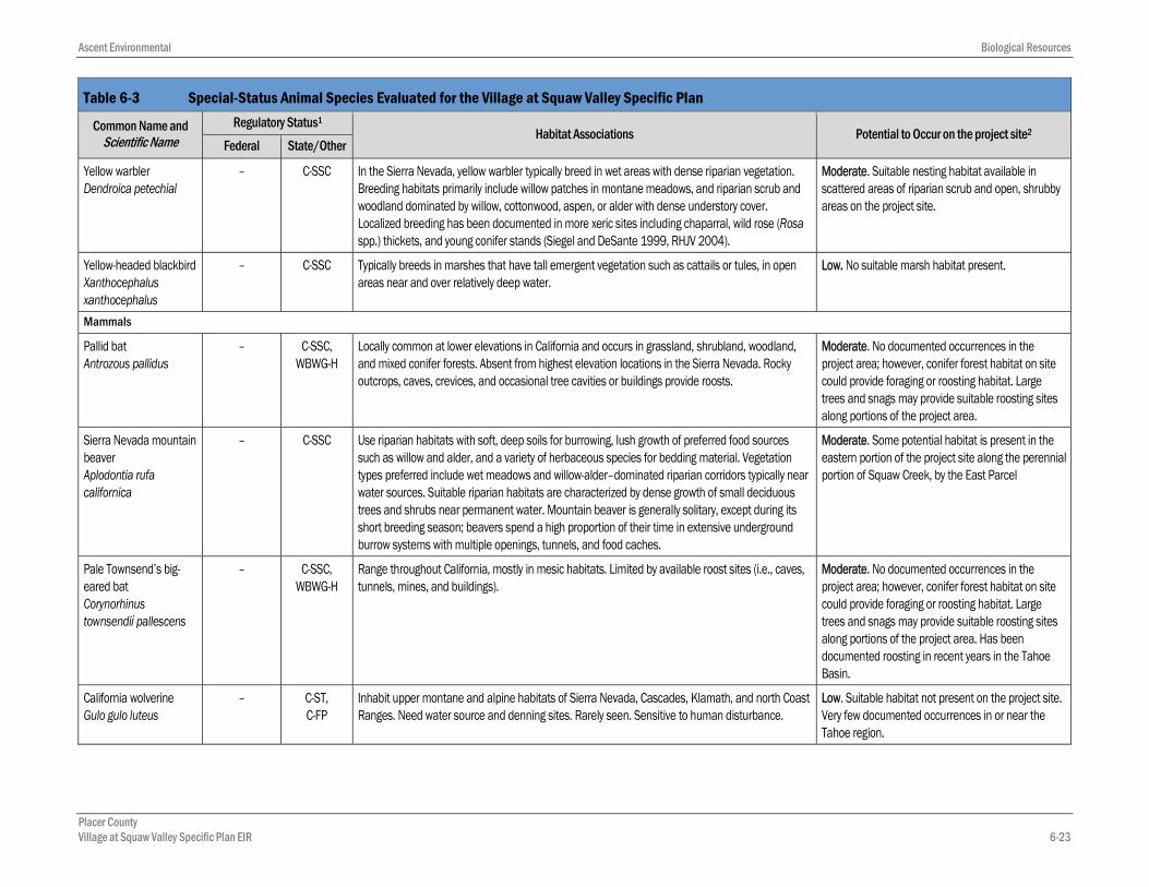
Table 6-3 Special-Status Animal Species Evaluated for the Village at Squaw Valley Specific Plan
Common Name and Scientific Name
Regulatory Status1
Habitat Associations Potential to Occur on the project site2 Federal State/Other
Fish
Mountain sucker Catostomus platyrhynchus
– C-SSC Occurs within the Middle Truckee River and its tributaries as well as the Tahoe Basin at mid to high elevations. This species generally occupies pool-like habitats, abundance greatest in areas with dense cover.
Low. No records exist from the project area. Habitat quality is marginal within the project area.
Lahontan cutthroat trout Oncorhynchus clarki henshawi
FT – Only trout species native to lakes and streams in the Tahoe Basin. Found in both lake and stream habitats, but spawn in stream environments. Lahontan cutthroat trout requires gravels and riffles for spawning and generally does not persist or occur with nonnative salmonids.
Low. The presence of non-native salmonids (rainbow trout, brook trout) reduces the likelihood this species could occur within the project area. No recent records of this species exist from the project area. However, this species is known to exist in the Middle Truckee River and some of its tributaries. This species is regularly stocked at sites throughout the Tahoe Basin and Truckee River.
Amphibians
Mount Lyell salamander Hydromantes platycephalus
– C-SSC Isolated populations occur in the Sierra Nevada, from Sierra County south to Tulare County, at approximately 4,000–12,000 feet elevation. Associated with large rock outcrops in mixed conifer, red fir, lodgepole pine, and subalpine habitats. Individuals usually found on the ground surface, in areas of open water in the form of seeps, drips, or spray.
Low. Suitable habitat is not present.
Sierra Nevada yellow-legged frog Rana sierrae
FE C-ST Occurs in upper elevation lakes, ponds, bogs, and slow-moving alpine streams. Most Sierra Nevada populations are found between 6,000–12,000 feet elevation. Almost always found within 3.280853 feet of water, and associated with montane riparian habitats in lodgepole pine, ponderosa pine, Jeffrey pine, sugar pine, white fir, whitebark pine, and wet meadow vegetation types. Alpine lakes inhabited by mountain yellow-legged frogs generally have grassy or muddy margin habitat, although below treeline sandy and rocky shores may be preferred. Suitable stream habitat can be highly variable, from high gradient streams with plunge pools and waterfalls, to low gradient sections through alpine meadows. Low-gradient streams are preferred because breeding and tadpole development cannot occur in streams with fast-moving water. Small streams are generally unoccupied and have no potential breeding locations because of the lack of depth for overwintering and refuge. Although Sierra Nevada yellow-legged frogs have been observed successfully breeding in shallow locations less than 7 feet deep, typically depth is an important factor for breeding locations since adults and larvae require overwintering habitat. For up to nine months, adults and larvae will live/hibernate below ice, or in nonfrozen portions of ponds or lakes, so adequate depth (greater than 2 m) is necessary to avoid having the pond or lake freeze through.
Moderate. Potential breeding habitat in Highland Lakes and in upstream portions of Squaw Creek and a perennial tributary to the south (outside the project area). A 1960’s record within the project area was located within Squaw Creek meadows. Current potential habitat within the project area is limited to dispersal habitat along Squaw Creek and within Squaw Creek meadows. Proposed Critical Habitat intersects the project area running along Squaw Creek. However, the presence of brook, brown, and rainbow trout in addition to the high amount of human disturbance make the portions of Squaw Creek within the project area marginal for Sierra Nevada yellow-legged frogs.

Ascent Environmental Biological Resources
Placer County Village at Squaw Valley Specific Plan EIR 6-21
Table 6-3 Special-Status Animal Species Evaluated for the Village at Squaw Valley Specific Plan
Common Name and Scientific Name
Regulatory Status1
Habitat Associations Potential to Occur on the project site2 Federal State/Other
Birds
Northern goshawk Accipiter gentilis
– C-SSC In the Sierra Nevada, this species generally requires mature conifer forests with large trees, snags, downed logs, dense canopy cover, and open understories for nesting; aspen stands also are used for nesting. Foraging habitat includes forests with dense to moderately open overstories and open understories interspersed with meadows, brush patches, riparian areas, or other natural or artificial openings. Goshawks reuse old nest structures and maintain alternate nest sites.
Moderate. May forage on project site. However, the project site is highly disturbed and does not support suitable nesting habitat.
Northern harrier Circus cyaneus
– C-SSC Found in a variety of open grassland, wetland, and agricultural habitats. Open wetland habitats used for breeding include marshy meadows, wet and lightly grazed pastures, and freshwater and brackish marshes. Breeding habitat also includes dry upland habitats, such as grassland, cropland, drained marshland, and shrub-steppe in cold deserts. Winters throughout California where suitable habitat occurs. Wintering habitat includes open areas dominated by herbaceous vegetation, such as grassland, pastures, cropland, coastal sand dunes, brackish and freshwater marshes, and estuaries (Grinnell and Miller 1944, MacWhirter and Bildstein 1996).
Moderate. Suitable nesting and foraging habitat is present on the project site. Harriers occur nearby in the Martis Valley, and in the Upper Truckee Marsh in South Lake Tahoe.
Bald eagle Haliaeetus leucocephalus
– C-SE, C-FP Use ocean shorelines, lake margins, and river courses for both nesting and wintering. Most nests are within 1 mile of water, in large trees with open branches. Roost communally in winter.
Low. No suitable nesting or foraging habitat present.
Golden eagle Aquila chrysaetos
BGEPA C-FP Mountains and foothills throughout California. Nest on cliffs and escarpments or in tall trees. Low. Suitable nesting habitat is not present on the project site, and golden eagle is rare in the Tahoe region. Due to disturbance levels and habitat quality on the project site, and higher quality habitat outside the project site, golden eagle is not expected to nest or forage on the project site.
Peregrine falcon Falco peregrinus
– C- FP Nest and roost on protected ledges of high cliffs, usually adjacent to water bodies and wetlands that support abundant avian prey.
Low. Suitable nesting habitat not present on the project site. Peregrine falcons could occasionally forage in the Olympic Valley and other areas within or near the project area.
California spotted owl Strix occidentalis occidentalis
– C-SSC Occur in several forest vegetation types including mixed conifer, ponderosa pine, red fir, and montane hardwood. Nesting habitat is generally characterized by dense canopy closure (i.e., greater than 70 percent) with medium to large trees and multistoried stands (i.e., at least two canopy layers). Foraging habitat can include intermediate to late-successional forest with greater than 40 percent canopy cover.
Moderate. No suitable nesting habitat present, and the project site is subject to high levels of human disturbance. Species could forage on the project site, and is known to nest nearby.

Biological Resources Ascent Environmental
Placer County 6-22 Village at Squaw Valley Specific Plan EIR
Table 6-3 Special-Status Animal Species Evaluated for the Village at Squaw Valley Specific Plan
Common Name and Scientific Name
Regulatory Status1
Habitat Associations Potential to Occur on the project site2 Federal State/Other
Long-eared owl Asio otus
– C-SSC Found in a variety of habitat types throughout its range. Nest in woodland, forest, and open settings (e.g., grassland, shrub-steppe, and desert). Occupy wooded and nonwooded areas that support relatively dense vegetation (e.g., trees, shrubs) adjacent to or within larger open areas such as grasslands or meadows (i.e., habitat edges) (Bloom 1994; Marks, Evans, and Holt 1994). This species also has been documented breeding in contiguous conifer forest habitat with heavy mistletoe infestation (Bull, Wright, and Henjum 1989). Trees and shrubs used for nesting and roosting include oaks, willows, cottonwoods, conifers, and junipers (Marks, Evans, and Holt 1994).
Moderate. Some suitable nesting and foraging habitat is present on the project site, but it is highly disturbed. Species has been documented in the Tahoe region.
Great gray owl Strix nebulosa
– C-SE Found in Central Sierra mature mixed conifer forests near meadows. Scattered along the west slope of the Sierra, between 4,500 and 7,500 feet elevation, from Plumas County to Yosemite National Park.
Low. Suitable nesting habitat is not present on the project site, and the species has not been documented in the area.
Black-backed woodpecker Picoides arcticus
– C-C Occurs in a variety for conifer forest types, but strongly associated with unlogged, severely-burned forest with abundant snags. Also strongly associated with areas of high tree mortality from beetles.
Low. Stands of high-severity postfire forest highly suitable for breeding are not present on the project site.
Willow flycatcher Empidonax traillii
– C-SE In the Sierra Nevada, suitable habitat typically consists of montane meadows that support riparian deciduous shrubs (particularly willows) and remain wet through the nesting season (i.e., midsummer). Important characteristics of suitable meadows include a high water table that results in standing or slow-moving water, or saturated soils (e.g., “swampy” conditions) during the breeding season; abundant riparian deciduous shrub cover (particularly willow); and riparian shrub structure with moderate to high foliar density that is uniform from the ground to the shrub canopy. Most breeding occurrences are in meadows larger than 19 acres, but the average size of occupied meadows is approximately 80 acres. Although less common in the Sierra Nevada, riparian habitat along streams also can function as suitable habitat for willow flycatcher. However, those areas must support the hydrologic and vegetation characteristics described for suitable meadows (e.g., standing or slow-moving water, and abundant and dense riparian vegetation).
Moderate. Potential nesting habitat occurs in the Squaw Valley meadow, but not within the project site. Riparian scrub on the project site would not likely be suitable for nesting; however, species could move through or forage on project site.
Olive-sided flycatcher Contopus cooperi
– C-SSC Summer resident and migrant that breeds primarily in late-succession conifer forest with open canopy. Species prefers to forage near forest openings or edges.
Moderate. Mature conifer forest in the project site within the Village and East Lot areas provides suitable habitat, although the area is disturbed.
Bank swallow Riparia riparia
– C-ST Nests in fine-textured or sandy banks or cliffs along rivers, streams, ponds, or lakes. Typically nests in colonies.
Low. No suitable habitat present on the project site. Additionally, the Tahoe region is not within the current breeding range of bank swallow (see Garrison 1998).
Black swift Cypseloides niger
– C-SSC Nests on canyon walls near water and sheltered by overhanging rock or moss, preferably near waterfalls or on sea cliffs. It breeds in California from May to September.
Low. No suitable habitat present on the project site.
Ascent Environmental Biological Resources
Placer County Village at Squaw Valley Specific Plan EIR 6-23
Table 6-3 Special-Status Animal Species Evaluated for the Village at Squaw Valley Specific Plan
Common Name and Scientific Name
Regulatory Status1
Habitat Associations Potential to Occur on the project site2 Federal State/Other
Yellow warbler Dendroica petechial
– C-SSC In the Sierra Nevada, yellow warbler typically breed in wet areas with dense riparian vegetation. Breeding habitats primarily include willow patches in montane meadows, and riparian scrub and woodland dominated by willow, cottonwood, aspen, or alder with dense understory cover. Localized breeding has been documented in more xeric sites including chaparral, wild rose (Rosa spp.) thickets, and young conifer stands (Siegel and DeSante 1999, RHJV 2004).
Moderate. Suitable nesting habitat available in scattered areas of riparian scrub and open, shrubby areas on the project site.
Yellow-headed blackbird Xanthocephalus xanthocephalus
– C-SSC Typically breeds in marshes that have tall emergent vegetation such as cattails or tules, in open areas near and over relatively deep water.
Low. No suitable marsh habitat present.
Mammals
Pallid bat Antrozous pallidus
– C-SSC, WBWG-H
Locally common at lower elevations in California and occurs in grassland, shrubland, woodland, and mixed conifer forests. Absent from highest elevation locations in the Sierra Nevada. Rocky outcrops, caves, crevices, and occasional tree cavities or buildings provide roosts.
Moderate. No documented occurrences in the project area; however, conifer forest habitat on site could provide foraging or roosting habitat. Large trees and snags may provide suitable roosting sites along portions of the project area.
Sierra Nevada mountain beaver Aplodontia rufa californica
– C-SSC Use riparian habitats with soft, deep soils for burrowing, lush growth of preferred food sources such as willow and alder, and a variety of herbaceous species for bedding material. Vegetation types preferred include wet meadows and willow-alder–dominated riparian corridors typically near water sources. Suitable riparian habitats are characterized by dense growth of small deciduous trees and shrubs near permanent water. Mountain beaver is generally solitary, except during its short breeding season; beavers spend a high proportion of their time in extensive underground burrow systems with multiple openings, tunnels, and food caches.
Moderate. Some potential habitat is present in the eastern portion of the project site along the perennial portion of Squaw Creek, by the East Parcel
Pale Townsend’s big-eared bat Corynorhinus townsendii pallescens
– C-SSC, WBWG-H
Range throughout California, mostly in mesic habitats. Limited by available roost sites (i.e., caves, tunnels, mines, and buildings).
Moderate. No documented occurrences in the project area; however, conifer forest habitat on site could provide foraging or roosting habitat. Large trees and snags may provide suitable roosting sites along portions of the project area. Has been documented roosting in recent years in the Tahoe Basin.
California wolverine Gulo gulo luteus
– C-ST, C-FP
Inhabit upper montane and alpine habitats of Sierra Nevada, Cascades, Klamath, and north Coast Ranges. Need water source and denning sites. Rarely seen. Sensitive to human disturbance.
Low. Suitable habitat not present on the project site. Very few documented occurrences in or near the Tahoe region.

Biological Resources Ascent Environmental
Placer County 6-24 Village at Squaw Valley Specific Plan EIR
Table 6-3 Special-Status Animal Species Evaluated for the Village at Squaw Valley Specific Plan
Common Name and Scientific Name
Regulatory Status1
Habitat Associations Potential to Occur on the project site2 Federal State/Other
Spotted bat Euderma maculatum
C-SSC Optimal habitats in the study area are cliff faces and mixed conifer forests up to 10,000 feet. Roosts in rock crevices and cliffs high off the ground.
Moderate. No documented occurrences in the study area; however, conifer forest habitat in the project area and on site could provide foraging habitat and tall, rocky outcrops in the surrounding mountains could provide roosting habitat.
Western red bat Lasiurus blossevillii
– C-SSC, WBWG-H
Day roosting common in edge habitats adjacent to streams or open fields, in orchards, and sometimes in urban areas. An association with intact riparian habitat may exist (particularly willows, cottonwoods, and sycamores).
Moderate. Some potential roosting and foraging habitat exists along the riparian corridors, and the species has been detected in the Tahoe Basin.
Sierra Nevada snowshoe hare Lepus americanus tahoensis.
– C-SSC In the Sierra Nevada, found in boreal zones, typically inhabiting riparian communities with thickets of deciduous trees and shrubs such as willows and alders.
Moderate. Potential habitat occurs in the eastern portion of project site near Squaw Creek meadows and the East Parcel.
Western white-tailed jackrabbit Lepus townsendii
– C-SSC Year-round resident in sagebrush, subalpine conifer, juniper, and other habitats along the crest and the eastern slope of the Sierra Nevada. Uncommon to rare.
Low. Suitable habitat is not present on the project site. Species is rare.
Pacific fisher Martes pennanti pacifica
FC C-SSC Inhabits stands of pine, Douglas fir, and true fir in northwestern California and Cascade-Sierra ranges. Fishers are considered extirpated throughout much of the Central and Northern Sierra Nevada. No longer considered present in the Tahoe region; no current records.
None. Considered extirpated from the Tahoe Region.
Sierra Nevada red fox Vulpes vulpes necator
– C-ST Inhabits upper montane and alpine habitats of Sierra Nevada, Cascades, Klamath, and north Coast Ranges. Need water source and denning sites. Rarely seen. Sensitive to human disturbance. No longer considered present in the Tahoe Basin; no current records.
None. Considered extirpated from the Tahoe area.
1 Regulatory Status Definitions: Federal: FT = Threatened species under the Federal Endangered Species Act FE = Endangered species under the Federal Endangered Species Act FC = Candidate for listing under the Federal Endangered Species Act BGEPA = Protected under the Bald and Golden Eagle Protection Act
State/Other: CA—California Department of Fish and Game: C-SE = Endangered C-ST = Threatened
C-FP = Fully Protected C-C = Candidate for listing C-SSC = Species of special concern
Western Bat Working Group WBWG-H = Designated as High Priority by the Western Bat Working Group
2 Potential for Occurrence Definitions: Present—Species was observed in the project area during site visits conducted for this analysis or was documented there by another reputable source. High—All of the species’ specific life history requirements can be met by habitat present in the project area, and populations are known to occur in the immediate vicinity. Moderate—Some or all of the species life history requirements are provided by habitat in the project area; populations may not be known to occur in the immediate vicinity, but are known to occur in the Region. Low—Species not likely to occur because of marginal habitat quality or distance from known occurrences. None—None of the species’ life history requirements are provided by habitat in the project area and/or the project area is outside of the known distribution for the species. Any occurrence would be very unlikely. Sources: CDFW 2014a, CNPS 2014, Salix Consulting (2012-2014); compiled by Ascent Environmental in 2014

Ascent Environmental Biological Resources
Placer County Village at Squaw Valley Specific Plan EIR 6-25
6.1.7 Waters of the United States
A preliminary wetland delineation and constraint maps for portions of the project site were prepared by Salix Consulting between 2011 and 2014 as described above in Section 6.1. The description of waters of United States in this document is based on these reports. The Salix constraints maps did not cover the entirety of the project site and assessments will need to be completed for the unsurveyed locations prior to construction as described in the impact and mitigation discussion below. (The unsurveyed areas are limited to certain off-site utility corridors and potential trails; reconnaissance-level surveys have been performed, but further site-specific surveys will be necessary in order to comply with Corps requirements.)
Seven types of potential wetlands and other waters of the United States have been mapped on the project site for a total of approximately 8.23 acres (Table 6-4; Exhibits 6-1 and 6-2). These include: wetland swale, seep, seasonal wetland, wet meadow, perennial stream, intermittent stream, and ephemeral stream. This area includes the portion of Squaw Creek proposed for restoration. See Appendix E for more detailed maps of wetland delineation features within lot numbers.
Table 6-4 Acres of Potential Wetlands and Other Waters of the United States within the Project Site Wetlands and Other Waters of the U.S.1 Main Village East Parcel Utilities and Other Facilities Total Acres on Project Site
Seep 0.330
S-1* 0.055 0.055
S-2 0.006 0.006
S-3 - 0.039 0.039
Seep/Alder Coffeeberry Scrub2 - - - S/ACS-1 0.214 0.214
Seep/Willow Alder Scrub
S/WAS-1 0.002 - 0.002
S/WAS-2 0.015 0.015
Seasonal Wetland 0.425
SW-1 0.028 0.028
SW-2 0.044 0.044
SW-3 0.004 0.004
SW-4 0.002 0.002
SW-5 0.036 0.037
SW-6 0.007 0.007
SW-7 0.010 0.010
SW-8 0.002 0.002
SW-9 0.001 0.001
Seasonal Wetland/Willow Scrub
SW/WS-1 0.158 0.035 0.193
SW/WS-2 0.097 0.097
Wet Meadow 1.081
WM-1 0.231 0.231
WM-2 0.053 0.053

Biological Resources Ascent Environmental
Placer County 6-26 Village at Squaw Valley Specific Plan EIR
Table 6-4 Acres of Potential Wetlands and Other Waters of the United States within the Project Site Wetlands and Other Waters of the U.S.1 Main Village East Parcel Utilities and Other Facilities Total Acres on Project Site
WM-3 0.067 - - 0.115
WM-4 0.047 - - 0.047
WM-5 - - 0.018 0.018
WM-6 - - 0.0002 0.0002
WM-7 - - 0.003 0.003
WM-8 - - 0.0002 0.0002
WM-9 - - 0.314 0.314
WM-10 - - 0.275 0.275
Wet Meadow/Willow Scrub
WM/WS-1 - - 0.025 0.025
Wetland Swale - - - 0.564
WS-1 0.001 - - 0.001
WS-2 0.003 - - 0.003
WS-3 0.412 0.021 0.433
WS-4 - 0.001 0.001
WS-5 - 0.042 0.001 0.043
WS-6 - 0.001 0.002 0.003
WS-7 - 0.012 - 0.012
WS-8 0.005 - 0.005
Wetland Swale/Willow Alder Scrub
WS/WAS-1 - 0.063 0.063
Ephemeral Stream - 0.006
ES-1 - 0.002 0.002
ES-2 - 0.001 0.001
ES-3 - 0.0004 0.0004
ES-4 - 0.002 0.002
ES-5 - 0.0002 0.0002
ES-6 - 0.0003 0.0003
Intermittent Stream - 5.229
IS-1 0.080 0.080
IS-2 0.011 0.011
IS-3 0.024 0.024
IS-4 0.006 0.006
IS-5 4.660 4.673
IS-6 0.040 0.028
IS-7 0.231 0.231
IS-8 0.030 0.001 0.131
IS-9 0.224 0.117

Ascent Environmental Biological Resources
Placer County Village at Squaw Valley Specific Plan EIR 6-27
Table 6-4 Acres of Potential Wetlands and Other Waters of the United States within the Project Site Wetlands and Other Waters of the U.S.1 Main Village East Parcel Utilities and Other Facilities Total Acres on Project Site
IS-10 0.029 0.029
Perennial Stream 0.433
PS-1 0.050 0.050
PS-2 0.199 0.199
PS-3 0.072 0.073
PS-4 0.111 0.111
Detention Ponds 0.106
DP-1 0.063 0.063
DP-2 0.043 0.043
Total Potential Jurisdictional Features3 6.348 0.840 1.045 8.233 1 See Appendix BE maps for locations of these identified features. Alphanumeric codes were used to identify each potential jurisdictional feature in these exhibits and
the wetland delineation. 2 Subclassifications for Waters of the United States in Seeps, Seasonal Wetlands, Wet Meadows, and Wetland Swales are included to provide consistency with habitat
classifications in Table 6-1 and Exhibits 6-1 and 6-2.
3 Any difference in acres from Table 6-1 is solely a result of rounding.
Source: Compiled by Ascent Environmental in 2014 based on Salix Consulting Surveys (2012-2014)
WILDLIFE MOVEMENT CORRIDORS The management plan for the Loyalton-Truckee Deer Herd (CDFG 1982, 2010b) shows that Olympic Valley is included in the Verdi Sub-Unit of the Loyalton-Truckee Deer Herd summer and migratory range. The Verdi sub-unit of the Loyalton-Truckee Deer Herd is identified in the 1982 Management Plan as migrating from the eastern Sierra Nevada foothills outside of Reno, Nevada, southwest into eastern Sierra, Nevada, and Placer counties in California during the spring and summer months after breeding. As described in the Loyalton-Truckee Deer Herd Management Plan (1982, 2010b), individuals migrate along the northern and southern sides of Interstate 80 corridor from the Truckee Meadows in Nevada to as far west as Donner Lake, as well as travelling south and southwest from this corridor to as far as the western Lake Tahoe Basin. Olympic Valley is located in the summer range of the deer herd. Migratory corridors are believed to often coincide with riparian habitat corridors. One migratory corridor is believed to cross into Martis Valley as deer move towards the western Lake Tahoe Basin.
Fawning habitat has been identified along the Truckee River, near Dry Lake in the Martis Valley, and Lookout Mountain (Town of Truckee 2014), all to the north and northeast of Olympic Valley. Fawning has been documented in the last five years at Northstar-at-Tahoe. CDFG maps also show the southern edge of Northstar-at-Tahoe near Mt. Pluto as a fawning area (EDAW/AECOM 2009). Since fawning occurs within Martis Valley and Northstar-at-Tahoe, it is possible that some fawning may also occur in suitable habitat along the migratory corridor that extends into the Lake Tahoe Basin. While not designated as an important fawning area, the meadows associated with Squaw Creek could be used by some migrating or resident deer for fawning.
The 1982 Loyalton-Truckee Deer Herd Management Plan is 30 years old, and deer migratory and fawning patterns have been shown to have shifted somewhat since the Plan’s completion due to development in the general region, increased traffic on SR 267 and SR 89, and the expansion of I-80. Additionally, over the last 15 years, migratory habitat loss and fragmentation has increased throughout the herds’ range because of residential development. The mule deer population has generally declined over the last few decades, with the loss of wintering habitat and reduced access to wintering areas being a primary contributor to this decline (CDFG 2010b). In the update to the Deer Herd Management plan, changes were noted based on

Biological Resources Ascent Environmental
Placer County 6-28 Village at Squaw Valley Specific Plan EIR
various radio telemetry studies. Telemetry studies from the 1990s showed some use by migratory deer around Martis Valley, but none to the south or southwest where the VSVSP project site is located (CDFG 2010b). Radio telemetry studies from 2002-2005 did not observe Loyalton-Truckee Deer Herd migratory deer using the area south of Highway 80 (CDFG 2010b). In 2009, RMT Inc. conducted a study on the movement and migration of mule deer at the proposed Canyon Springs development site (Town of Truckee 2014). This site is located 12 miles to the northwest of the VSVSP project site in the town of Truckee, at generally the same elevation as Olympic Valley, and directly within the mapped migratory pathway of the herd. The study documented deer using the area for forage and cover. While it was generally believed that deer used the general area for migration, no direct evidence of migration was found from the study and most of the observed deer were thought to be resident. Similarly, a portion of the deer observed in Olympic Valley may be resident deer and not migratory based on this data and the previous telemetry studies conducted in the 1990s and early 2000s. If there is a resident, year-round deer population in the area, they may move seasonally to different locations within the general Truckee-Tahoe region, but not make longer migrations down the slope of the Sierra Nevada.
The California Essential Habitat Connectivity Project is a recently-completed, peer-reviewed statewide assessment of important habitat linkages (Spencer et al. 2010). The project’s goal was to identify large remaining blocks of intact habitat or natural landscape at a coarse spatial scale, and model linkages between them that are important to maintain as corridors for wildlife. This coarse-scale, statewide map was based primarily on the concept of ecological integrity over a very large region, rather than the specific movement and other life history requirements of particular species. There are no Essential Habitat Connectivity Corridors located within the project area (CDFW 2014b).
6.1.8 Federal Recovery Plans and Critical Habitat
In April of 2014, the U.S. Fish and Wildlife Service (USFWS) listed as Endangered the Sierra Nevada yellow-legged frog (Rana sierrae), Northern District Population. Critical Habitat for the frog was also proposed at that time. The Five Lakes Subunit (Subunit 2D) of the proposed critical habitat intersects the project site as it follows Squaw Creek from the upper watershed into the Village Core area. The unit intersects lots 1, 3, 4, 5, 6, 7, 8, 9, 10, 11, 12, 13, 14, 17, 18, 19, 20, 21, 22, 23, 24, 25, 26, and 33. It ends at the western edge of the golf-course, just past lots 26 and 10. USFWS has not released a proposed recovery plan for the Sierra Nevada yellow-legged frog.
REGULATORY SETTING 6.2
6.2.1 Federal
FEDERAL ENDANGERED SPECIES ACT The USFWS and National Marine Fisheries Service (NMFS) are charged with oversight of species designated as threatened or endangered under the federal ESA of 1973 (Title 50, Part 17 of the Code of Federal Regulations [i.e., 50 CFR 17]), as amended under the USFWS Mitigation Policy of 1956 (Title 16, Chapter 35, Section 1531 of the United States Code [16 USC 1531 et seq.]), as well as those species that are designated by Region 1 of the USFWS as species of concern.
USFWS has authority over projects that may result in take of a federally listed species. Under the ESA, “take” is to “harass, harm, pursue, hunt, shoot, wound, kill, trap, capture or collect or to attempt to engage in any such conduct” (Public Law 93-205, as amended by Section 3 of Public Law 107-136 [16 USC 1532]). The loss of habitat can also be considered “take” under the ESA. For projects with a federal nexus, such as this project, the process is accomplished through consultation under ESA Section 7 (16 USC 1536[a][2]), which

Ascent Environmental Biological Resources
Placer County Village at Squaw Valley Specific Plan EIR 6-29
produces a biological assessment (BA) to describe the impact mechanisms and any adverse effects on the listed population. Information within the BA is used to prepare the biological opinion (BO).
MIGRATORY BIRD TREATY ACT The Migratory Bird Treaty Act, enacted in 1918, domestically implements a series of international treaties that provide protection for migratory birds. It authorizes the Secretary of the Interior to regulate the taking of migratory birds and provides that it shall be unlawful, except as permitted by regulations, to pursue, take, or kill any migratory bird, or any part, nest, or egg of any such bird (16 USC 703). This prohibition includes both direct and indirect acts, although harassment and habitat modification are not included unless they result in direct loss of birds, nests, or eggs. The current list of species protected by the Migratory Bird Treaty Act includes several hundred species, which is essentially all the native birds, in the United States.
BALD AND GOLDEN EAGLE PROTECTION ACT The Bald and Golden Eagle Protection Act, enacted in 1940 and amended multiple times since, prohibits the taking of bald and golden eagles without a permit from the Secretary of the Interior. Similar to the ESA, the Bald and Golden Eagle Protection Act defines “take” to include “pursue, shoot, shoot at, poison, wound, kill, capture, trap, collect, molest or disturb” (16 USC 668-668c). For the purpose of the act, disturbance that would injure an eagle, decrease productivity, or cause nest abandonment, including habitat alterations that could have these results, are considered take and can result in civil or criminal penalties.
SECTION 404 OF THE CLEAN WATER ACT Section 404 of the Clean Water Act (CWA) establishes a requirement for a project applicant to obtain a permit before engaging in any activity that involves any discharge of dredged or fill material into waters of the United States, including wetlands. Waters of the United States include navigable waters of the United States, interstate waters, all other waters where the use or degradation or destruction of the waters could affect interstate or foreign commerce, tributaries to any of these waters, and wetlands that meet any of these criteria or that are adjacent to any of these waters or their tributaries. Under Section 404 of the CWA, USACE regulates and issues permits for activities that involve the discharge of dredged or fill materials into waters of the United States. Fills of less than 0.5 acre of non-tidal waters of the United States for residential, commercial, or institutional development projects can generally be authorized under USACE’s nationwide permit (NWP) program, provided that the project satisfies the terms and conditions of the particular NWP. Fills that do not qualify for a NWP require a letter of permission or an individual permit.
SECTION 401 WATER QUALITY CERTIFICATION Under Section 401 of the CWA, an applicant for a Section 404 permit must obtain a certificate from the appropriate state agency stating that the intended dredging or filling activity is consistent with the State’s water quality standards and criteria. In California, the authority to grant water quality certification is delegated by the State Water Resources Control Board to the nine Regional Water Quality Control Boards (RWQCBs). The project area is within the jurisdiction of the Lahontan RWQCB.
6.2.2 State
CALIFORNIA ENDANGERED SPECIES ACT The CESA prohibits the taking of state-listed endangered or threatened species, as well as candidate species being considered for listing. Applicants may obtain a Section 2081 incidental take permit if the impacts of the take are minimized and fully mitigated and the take would not jeopardize the continued existence of the species. A “take” of a species, under CESA, is defined as an activity that would directly or indirectly kill an

Biological Resources Ascent Environmental
Placer County 6-30 Village at Squaw Valley Specific Plan EIR
individual of a species. The CESA definition of take does not include “harm” or “harass” as is included in the federal ESA.
CALIFORNIA FISH AND GAME CODE SECTION 1602—STREAMBED ALTERATION All diversions, obstructions, or changes to the natural flow or bed, channel, or bank of any river, stream, or lake in California that supports wildlife resources are subject to regulation by CDFW (formerly CDFG) under Sections 1600 et seq. of the California Fish and Game Code. Under Section 1602, it is unlawful for any person to substantially divert or obstruct the natural flow or substantially change the bed, channel, or bank of any river, stream, or lake designated by CDFW, or use any material from the streambeds, without first notifying CDFW of such activity and obtaining a Lake or Streambed Alteration Agreement authorizing such activity. “Stream” is defined as a body of water that flows at least periodically or intermittently through a bed or channel having banks and that supports fish or other aquatic life. CDFW’s jurisdiction within altered or artificial waterways is based on the value of those waterways to fish and wildlife.
CALIFORNIA FISH AND GAME CODE SECTIONS 3503–3503.5—PROTECTION OF BIRD NESTS AND RAPTORS Section 3503 of the California Fish and Game Code states that it is unlawful to take, possess, or needlessly destroy the nest or eggs of any bird. Section 3503.5 specifically states that it is unlawful to take, possess, or destroy any raptors (i.e., hawks, owls, eagles, and falcons), including their nests or eggs. Violations of these codes include destroying active nests by removing the vegetation in which the nests are located and disturbance of nesting pairs that results in the failure of active raptor nests.
CALIFORNIA NATIVE PLANT PROTECTION ACT In addition to CESA, the California Native Plant Protection Act provides protection to endangered and rare plant species, subspecies, and varieties of wild native plants in California. The California Native Plant Protection Act definitions of “endangered” and “rare” closely parallel the CESA definitions of endangered and threatened plant species.
PORTER-COLOGNE WATER QUALITY CONTROL ACT The Porter-Cologne Water Quality Control Act requires that each of the nine RWQCBs prepare and periodically update basin plans for water quality control. Each basin plan sets forth water quality standards for surface water and groundwater and actions to control nonpoint and point sources of pollution to achieve and maintain these standards. Basin plans offer an opportunity to protect wetlands through the establishment of water quality objectives. The RWQCBs’ jurisdiction includes waters of the United States as well as areas that meet the definition of “waters of the state.” Waters of the state are defined as any surface water or groundwater, including saline waters, within the boundaries of the state. The RWQCBs have the discretion to take jurisdiction over areas not federally protected under Clean Water Act Section 404 provided they meet the definition of waters of the state. Mitigation requiring no net loss of wetland functions and values of waters of the state is typically required by the RWQCBs.
Z’BERG-NEJEDLY FOREST PRACTICE ACT The Z’Berg-Nejedly Forest Practice Act (Forest Practice Act) and the associated California Public Resource Code (Division 4, Chapter 8) establish the authority for California Department of Forestry and Fire Protection (CAL FIRE) to act as the lead agency for timber harvest activities on non-federal land in the state. The Forest Practice Act was enacted to ensure that logging is done in a manner that will preserve and protect California fish, wildlife, forests, and streams. The California Forest Practice Rules (Title 14, California Code of Regulations) provide the explicit requirements by which Registered Professional Foresters prepare Timber Harvest Plans (THP) and by which CAL FIRE serves as the lead agency and reviews their completeness,

Ascent Environmental Biological Resources
Placer County Village at Squaw Valley Specific Plan EIR 6-31
adequacy, and enforceability. CAL FIRE is responsible for administering THP Regulations throughout California on all non-federal timberland. This applies regardless of zoning and includes lands inside of city limits. The removal of commercial timber species from forested areas is included under these regulations and may require a THP, a Timberland Conversion Permit, or another type of timber harvest plan exemption or emergency document, depending on project type.
6.2.3 Local
PLACER COUNTY CODE OF ORDINANCES The following regulations from the Placer County Code of Ordinances are applicable to biological resources in the project site:
Article 12.16. Tree Preservation Generally (Countywide) Riparian Zone Requirements. No tree permit or discretionary approval for any development activity within
a riparian zone (50 to 100 feet from streams/waterbodies) shall be approved until environmental impacts within the riparian zone are identified, an environmental determination is made and the mitigation measures identified (Chapter 18, Placer County Code). Additionally, no development activity shall be permitted until any stream alteration agreement or mitigation agreements required by CDFW have been completed.
Removal of More than Fifty Percent of Trees. Except for developed, single-family residential lots that cannot be subdivided, the removal of more than fifty (50) percent of existing native trees, 6 inches dbh or greater, shall be subject to the issuance of a tree permit.
Article 12.20. Tree Preservation in Area East of Sierra Summit No person shall cut down, move, remove, kill, or materially damage any live tree 6 inches dbh or over, or attach any appurtenance to a tree, without first having obtained a tree cutting permit from the permit-issuing authority, unless such tree is located on lands devoted to the growing and harvesting of timber for commercial purposes for which permits have been granted permitting timber harvesting. Such permits shall be unnecessary for the removal of trees proposed to be removed as approved in connection with the approval by the agency of a tentative map under the subdivision ordinance, except where such subdivision involves a land use conversion, or for the removal of trees as permitted under a permit issued pursuant to the grading ordinance, provided, however, that the standards contained in this article shall also be applicable to the approval of a tentative and final subdivision map and to the issuance of a grading permit.
Additionally, this ordinance limits tree cutting within the one hundred (100) year floodplain of a perennial or intermittent stream to diseased or hazardous trees or to thinning needed to protect the health and vigor of remaining trees.
Sections 8.16.265, 8.16.266, 8.16.268 of the Placer County Code Section 8.16.266-of the Placer County Code requires the installation of approved bear-resistant garbage can enclosures on all private property (including businesses) above 5,000 feet. The installation is required prior to the approval of new residential construction or within thirty days of notification by Placer County environmental health that installation of an approved bear-resistant garbage enclosure is required as the site was determined to be a bear access problem by Placer County. The bear-resistant garbage enclosures are required to be located within 20 feet of a county maintained road and outside of the road right-of-way. In addition, bear bins are required to be located a minimum of 15 feet from the edge of pavement of the road, in order to preserve required site distance for vehicles exiting a driveway. Section 8.16.268 outlines the use and maintenance of the bear-resistant garbage can enclosures by minimizing odor, not overloading the enclosure with garbage and ensuring that the doors around the enclosure are properly secured at all times.

Biological Resources Ascent Environmental
Placer County 6-32 Village at Squaw Valley Specific Plan EIR
PLACER COUNTY GENERAL PLAN The Placer County General Plan (2013) contains the following policies that are applicable to the proposed project:
Water Resources Policies Policy 6.A.1. The County shall require the provision of sensitive habitat buffers which shall, at a
minimum, be measured as follows: 100 feet from the centerline of perennial streams, 50 feet from centerline of intermittent streams, and 50 feet from the edge of sensitive habitats to be protected including riparian zones, wetlands, old growth woodlands, and the habitat of rare, threatened or endangered species. Based on more detailed information supplied as a part of the review for a specific project, the County may determine that such setbacks are not applicable in a particular instance or should be modified based on the new information provided. The County may, however, allow exceptions, such as in the following cases:
a. Reasonable use of the property would otherwise be denied;
b. The location is necessary to avoid or mitigate hazards to the public;
c. The location is necessary for the repair of roads, bridges, trails, or similar infrastructure; or
d. The location is necessary for the construction of new roads, bridges, trails, or similar infrastructure where the County determines there is no feasible alternative and the project has minimized environmental impacts through project design and infrastructure placement.
Policy 6.A.2. The County shall require all development in the 100-year floodplain to comply with the provisions of the Placer County Flood Damage Prevention Ordinance.
Policy 6.A.3. The County shall require development projects proposing to encroach into a creek corridor or creek setback to do one or more of the following, in descending order of desirability:
a. Avoid the disturbance of riparian vegetation;
b. Replace riparian vegetation (on-site, in-kind);
c. Restore another section of creek (in-kind); and/or
d. Pay a mitigation fee for restoration elsewhere (e.g., wetland mitigation banking program).
Policy 6.A.4. Where creek protection is required or proposed, the County should require public and private development to:
a. Preserve creek corridors and creek setback areas through easements or dedications. Parcel lines (in the case of a subdivision) or easements (in the case of a subdivision or other development) shall be located to optimize resource protection;
b. Designate such easement or dedication areas (as described in a. above) as open space;
c. Protect creek corridors and their habitat value by actions such as: 1) providing an adequate creek setback, 2) maintaining creek corridors in an essentially natural state, 3) employing creek restoration techniques where restoration is needed to achieve a natural creek corridor, (4) utilizing riparian vegetation within creek corridors, and where possible, within creek areas, 5) prohibiting the planting of invasive, non-native plants (such as Vinca major and eucalyptus) within creek corridors or creek setbacks, and 6) avoiding tree removal within creek corridors;
d. Provide recreation and public access near creeks consistent with other General Plan policies;
e. Use design, construction, and maintenance techniques that ensure development near a creek will not cause or worsen natural hazards (such as erosion, sedimentation, flooding, or water pollution) and will include erosion and sediment control practices such as: 1) turbidity screens and other
Ascent Environmental Biological Resources
Placer County Village at Squaw Valley Specific Plan EIR 6-33
management practices, which shall be used as necessary to minimize, sedimentation, and erosion, and shall be left in place until disturbed areas; and/or are stabilized with permanent vegetation that will prevent the transport of sediment off site; and 2) temporary vegetation sufficient to stabilize disturbed areas.
f. Provide for long-term creek corridor maintenance by providing a guaranteed financial commitment to the County which accounts for all anticipated maintenance activities.
Policy 6.A.5. The County shall continue to require the use of feasible and practical best management practices (BMPs) to protect streams from the adverse effects of construction activities and urban runoff and to encourage the use of BMPs for agricultural activities.
Policy 6.A.6. The County shall require that natural watercourses are integrated into new development in such a way that they are accessible to the public and provide a positive visual element.
Policy 6.A.7. The County shall discourage grading activities during the rainy season, unless adequately mitigated, to avoid sedimentation of creeks and damage to riparian habitat.
Policy 6.A.8. Where the stream environment zone has previously been modified by channelization, fill, or other human activity, the County shall require project proponents to restore such areas by means of landscaping, revegetation, or similar stabilization techniques as a part of development activities.
Wetland Policies Policy 6.B.1. The County shall support the “no net loss” policy for wetland areas regulated by the U.S.
Army Corps of Engineers, the U.S. Fish and Wildlife Service, and the California Department of Fish and Game. Coordination with these agencies at all levels of project review shall continue to ensure that appropriate mitigation measures and the concerns of these agencies are adequately addressed.
Policy 6.B.2. The County shall require new development to mitigate wetland loss in both regulated and nonregulated wetlands to achieve “no net loss” through any combination of the following, in descending order of desirability: (1) avoidance; (2) where avoidance is not possible, minimization of impacts on the resource; or (3) compensation, including use of a mitigation banking program that provides the opportunity to mitigate impacts to rare, threatened, and endangered species and/or the habitat which supports these species in wetland and riparian areas.
Policy 6.B.3. The County shall discourage direct runoff of pollutants and siltation into wetland areas from outfalls serving nearby urban development. Development shall be designed in such a manner that pollutants and siltation will not significantly adversely affect the value or function of wetlands.
Policy 6.B.5. The County shall require development that may affect a wetland to employ avoidance, minimization, and/or compensatory mitigation techniques. In evaluating the level of compensation to be required with respect to any given project, (a) on-site mitigation shall be preferred to off-site, and in-kind mitigation shall be preferred to out-of-kind; (b) functional replacement ratios may vary to the extent necessary to incorporate a margin of safety reflecting the expected degree of success associated with the mitigation plan; and (c) acreage replacement ratios may vary depending on the relative functions and values of those wetlands being lost and those being supplied, including compensation for temporal losses. The County shall continue to implement and refine criteria for determining when an alteration to a wetland is considered a less than significant impact under CEQA.
Biological Resources Ascent Environmental
Placer County 6-34 Village at Squaw Valley Specific Plan EIR
Fish and Wildlife Habitat Policies Policies 6.C.1 Identify and protect significant ecological resource areas and other unique wildlife habitats
critical to protecting and sustaining wildlife populations. Significant ecological resource areas include the following:
a. Wetland areas including vernal pools.
b. Stream environment zones.
c. Any habitat for rare, threatened or endangered animals or plants.
d. Critical deer winter ranges (winter and summer), migratory routes and fawning habitat.
e. Large areas of non-fragmented natural habitat, including Blue Oak Woodlands, Valley Foothill Riparian, vernal pool habitat.
f. Identifiable wildlife movement zones, including but not limited to, non-fragmented stream environment zones, avian and mammalian migratory routes, and known concentration areas of waterfowl within the Pacific Flyway.
g. Important spawning areas for anadramous fish.
Policy 6.C.2. The County shall require development in areas known to have particular value for wildlife to be carefully planned and, where possible, located so that the reasonable value of the habitat for wildlife is maintained.
Policy 6.C.5. The County shall require mitigation for development projects where isolated segments of stream habitat are unavoidably altered. Such impacts should be mitigated on-site with in-kind habitat replacement or elsewhere in the stream system through stream or riparian habitat restoration work.
Policy 6.C.9. The County shall require new private or public developments to preserve and enhance existing riparian habitat unless public safety concerns require removal of habitat for flood control or other public purposes. In cases where new private or public development results in modification or destruction of riparian habitat for purposes of flood control, the developers shall be responsible for acquiring, restoring, and enhancing at least an equivalent amount of like habitat within or near the project area.
Policy 6.C.11. Prior to approval of discretionary development permits involving parcels within a significant ecological resource area, the County will require, as part of the environmental review process, a biotic resources evaluation of the sites by a wildlife biologist.
SQUAW VALLEY GENERAL PLAN AND LAND USE ORDINANCE No policies in the SVGPLUO (Placer County 1983) apply directly to wildlife or special-status species or their habitat. The Environmental Resources Element requires minimizing adverse impacts on the unique resources of the area. Vegetation policies require any planning to minimize damage to existing vegetation and to revegetate all areas disturbed by construction. Revegetation of any cover temporarily removed or altered through construction activities is required (Section 118.16). To protect against erosion and sedimentation and loss of vegetation, a detailed Erosion Control, Drainage and Revegetation Plan would need to be submitted for any project (Section 118). Streams and waterways are given protection through requirements that construction not cause siltation or adversely affect the quality of water or fish habitat. Setbacks and protections from construction along the stream environment zone (100 year floodplain) are described in Section 115.18-115.23. Section 115.18 restricts adverse impacts from development activities within any undisturbed stream environmental zone. Where the floodplain has not been established, the area within 100 feet of the centerline of the stream will be left in its natural state (Section 139.14). There are additional setbacks for buildings and structures (Section 139.16). Snow storage is also not allowed within the 100-year floodplain (Section 121). Restoration is required for the approval of projects on adjoining

Ascent Environmental Biological Resources
Placer County Village at Squaw Valley Specific Plan EIR 6-35
properties when any stream environmental zone or floodplain has been adversely affected by channelization, fill or other human activity.
IMPACTS 6.3
6.3.1 Significance Criteria
Based on the Placer County CEQA checklist and Appendix G of the State CEQA Guidelines, the proposed project would result in a potentially significant impact on biological resources if it would:
have a substantial adverse effect, either directly or through habitat modifications, on any species identified as a candidate, sensitive, or special status species in local or regional plans, policies or regulations, or by CDFW, USFWS, or NOAA Fisheries;
substantially reduce the habitat of a fish or wildlife species, cause a fish or wildlife population to drop below self-sustaining levels, threaten to eliminate a plant or animal community, substantially reduce the number of restrict the range of an endangered, rare, or threatened species;
have a substantial adverse effect on the environment by converting oak woodlands;
have a substantial adverse effect on any riparian habitat or other sensitive natural community, including oak woodlands, identified in local or regional plans, policies or regulations, or by CDFW, USFWS, USACE, or NOAA Fisheries;
have a substantial adverse effect on federal or state protected wetlands as defined by Section 404 of the CWA (including, but not limited to, marsh, vernal pool, coastal, etc.) or as defined by state statute, through direct removal, filling, hydrological interruption, or other means;
interfere substantially with the movement of any native resident or migratory wildlife species or with established native resident or migratory wildlife corridors, or impede the use of native wildlife nesting or breeding sites;
conflict with any local policies or ordinances that protect biological resources, including oak woodland resources; or
conflict with the provisions of an adopted Habitat Conservation Plan, Natural Community Conservation Plan, or other approved local, regional, or state habitat conservation plan.
6.3.2 Methods and Assumptions
POLICIES PROPOSED IN THE SPECIFIC PLAN THAT COULD AFFECT PROJECT IMPACTS The following policies from The Village at Squaw Valley Specific Plan (VSVSP) (Squaw Valley Real Estate, LLC 2015) are applicable to the evaluation of biological resources effects:
Open Space Policy OS-6: Protect Squaw Creek by providing an appropriate open space corridor, and limiting activities
to those that do not degrade water quality or the stream and riparian habitat within the corridor. Appropriate activities within the Squaw Creek corridor may include sediment collection and/or sediment removal facilities and equipment, minor streambed alterations to improve flood control, and habitat or water quality, trail construction, fishing, and signage and other interpretive elements.

Biological Resources Ascent Environmental
Placer County 6-36 Village at Squaw Valley Specific Plan EIR
Squaw Creek Corridor Policy SC-1: Squaw Creek and the adjacent riparian area shall be designated Village-Conservation
Preserve. Activities within the corridor shall be limited to those that improve the creek and/or recreational amenities for celebration and public enjoyment of the restoration effort. In addition to measures designed to protect and enhance the creek and riparian corridor, minor improvements that have minimal impact, such as trails, shall be allowed within the corridor.
Policy SC-2: No buildings or structures over 400 square feet shall be constructed within the Squaw Creek riparian corridor, other than linear park and trail related facilities such as interpretive panels or kiosks, observation decks, restrooms, and picnic areas.
Policy SC-3: Roads, bridges, paths and other related facilities located within the riparian corridor shall not encroach on the creek channel, and shall be designed to minimize impacts on the creek habitat and stormwater capacity.
Wetlands Policy WE-1: Development shall avoid wetlands located within the 100-year floodplain to the extent feasible.
Policy WE-2: To the extent feasible, wetlands shall be avoided, unless relocation and/or modification of the wetland would increase the functional value of the wetland and/or receiving waters.
Policy WE-3: When wetlands cannot be avoided, a mitigation plan shall be developed before site disturbance.
Policy WE-4: Relocation, reconstruction and other changes in wetlands shall be designed in consultation with the Lahontan Regional Water Quality Control Board and the Army Corps of Engineers, and shall meet all applicable state and federal regulations.
Policy WE-5: The drainage system shall be designed to enhance the habitat value and water quality along the southern and eastern edges of the Plan Area.
Policy WE-6: BMPs, LIDs, and other measures shall be employed to ensure that water quality is not degraded in Squaw Creek or preserved wetlands.
Plants and Wildlife Policy PW-1: Protocol surveys for special-status species shall be conducted prior to any disturbance of
habitat areas (shown in Figure 7.5– Biological Resources in the Plan Area [in the Specific Plan]), and prior to removal of any trees during the active nesting season (February – September).
Policy PW-2: If special-status species are identified during preconstruction surveys, appropriate buffers and other protective measures shall be developed in consultation with the United States Fish and Wildlife Service (USFWS), the California Department of Fish and Wildlife (DFW) and Placer County.
Policy PW-3: Protocol level surveys for protected birds shall be conducted prior to removal of any trees during the active nesting season (February through September). Construction and other activities shall be avoided in the vicinity of active nests and nursery sites, unless it can be determined in consultation with the appropriate agency (USFWS or DFW) that the activities would not disrupt the nesting species.
Policy PW-4: Impacts to sensitive and special status species shall be mitigated in accordance with State and Federal trustee agency requirements.

Ascent Environmental Biological Resources
Placer County Village at Squaw Valley Specific Plan EIR 6-37
Trees Policy TR-1: To the extent feasible, healthy trees shall be avoided.
Policy TR-2: Where healthy trees must be removed, each project shall compensate for the loss of trees through compliance with the County Tree Ordinance.
Policy TR-3: Each project that removes commercial-grade trees shall be responsible for preparation of Timber Harvest Plan (THP), THP exemption, and/or compliance with a master THP if one is enforced. Preparation of a THP does not exempt tree removal from the County Tree Ordinance.
IMPACT ANALYSIS METHODOLOGY This section describes potential impacts to biological resources that could result from construction and operation of the VSVSP. Information in this section is based on data collected during reconnaissance-level field surveys, and review of other relevant documentation for the project site and surrounding area, including those listed above at the beginning of this chapter and in Section 6.1. The study area is considered a 5-mile radius of the Specific Plan area, while the project site is considered the area of direct impacts (including the Specific Plan area and any facilities or utilities associated with the Specific Plan). The project area includes the project site and the immediately surrounding area within Olympic Valley.
Primary Impact Mechanisms and Assumptions Potential impacts associated with the Specific Plan activities can be classified as either temporary or permanent. It is assumed that all construction impacts would occur during the late spring, summer, and early fall season when warmer, dry weather permits construction activity. Construction impacts would occur over a roughly 25-year period from approximately 2016 through 2040.
Temporary impacts would include noise related effects associated with construction activities, including the building, grading, excavation, or vegetation removal in areas. This analysis assumes that all temporary construction facilities (staging areas, construction offices) would be located within the established Village at Squaw Valley Specific Plan boundary, primarily in the existing surface parking lots. Therefore, no vegetation removal would occur from temporary construction facilities.
Permanent impacts generally include effects associated with groundwater pumping for domestic use, permanent tree or other vegetation removal, and with ongoing operation and maintenance activities resulting from the Specific Plan.
Vegetation and Wildlife Potential impacts of the Specific Plan on vegetation and wildlife resources were initially identified by overlaying GIS layers of Specific Plan components on the land cover maps of the project area and maps of sensitive biological resources. Any natural community and wildlife habitat that overlapped with an area of proposed modification was considered to be directly or indirectly affected during proposed construction. An estimate of the amount of vegetation removal planned for the clearing of work areas and proposed plan construction or habitat restoration was determined by taking land use zones and developing estimates for the amount of proposed vegetation removal within them. Disturbance and vegetation removal estimates are provided as parcel percentage impact assumptions in Appendix E. Assumptions were based on diagrams from the VSVSP, descriptions of proposed or allowable activities in each parcel included in the VSVSP, and input provided by the project applicant.
The assumed widths for new roads and widening of existing roads used for this analysis are based on those described in the Specific Plan (see Section 5.4, “Roadway Classifications,” of the Specific Plan). Additionally, the following disturbance buffers were used for proposed utility corridors and other features:

Biological Resources Ascent Environmental
Placer County 6-38 Village at Squaw Valley Specific Plan EIR
Drainage, Water, and Sewer Lines - 50 foot disturbance corridor. Water Tank - 50 foot disturbance area from edge of tank. Water Wells and Facilities - 50 foot disturbance from edge. Hiking Trails/Bike Paths - 10 foot disturbance corridor.
The entire proposed snow beach area was assumed to be affected by grading. Because there are uncertainties regarding the ultimate amount of disturbance from snow beach development, this conservative approach was used; actual disturbance could ultimately be less.
Not all utility corridors outside of the Specific Plan area boundary have been surveyed for sensitive habitats (e.g., wetlands). These areas will require surveys prior to any ground disturbance. A determination of habitat conditions in unsurveyed areas was made using aerial imagery for these areas and observations during reconnaissance surveys. All other areas have been surveyed and delineations of wetlands and waters of the United States have been submitted to the USACE. Verifications of the delineations by USACE had not yet been received as of the publication of this DEIR.
Fish and Aquatic Resources Construction activities that could result in temporary impacts to fish and aquatic resources include disturbance of aquatic habitats by equipment and/or persons, dewatering of surface water and/or groundwater, and potential contamination of surface water.
Long-term mechanisms that could produce impacts to fish and aquatic resources include changes to the surface hydrology, floodplains and channel features, operations of modified storm drainage network and urban runoff treatment, snow storage facilities and practices, erosion and sedimentation, and increases in the amounts, locations, and seasonal patterns of groundwater extraction.
6.3.3 Issues or Potential Impacts Not Discussed Further
ACTIVITIES Snow storage activities along roadsides involve the blowing or placement of snow during the winter months in areas that had already been covered by natural snowfall. This activity would have little to no impact to existing vegetation conditions and is not discussed further in the context of terrestrial biological resources. However, potential water quality impacts are considered relative to fisheries, aquatic resources, and jurisdictional waters.
SPECIAL STATUS SPECIES Section 6.1.5, “Special Status Species,” discusses all special-status plant and animal species evaluated in this analysis, and Tables 6-3 and 6-4 summarize the potential for each of these species to occur in the study area. Those plant and animal species not expected to occur, or with a low probability to occur (e.g. lack of suitable habitat, outside of elevational range or habitat range) are not addressed further in this DEIR. Implementation of the Specific Plan is not expected to affect those species.
OAK WOODLANDS No oak woodland communities are present within or adjacent to the project area. The project area is above the elevation range of oak woodland communities. Therefore, the Specific Plan would not affect oak woodlands, and this issue is not further addressed in this DEIR.

Ascent Environmental Biological Resources
Placer County Village at Squaw Valley Specific Plan EIR 6-39
MIGRATORY BIRD TREATY ACT Implementation of the Specific Plan could result in loss of nests of common birds that are protected by the MBTA. Loss of active nests of common species during project activities would not substantially reduce the abundance of any species, nor cause any species to drop below self-sustaining levels. As such, potential adverse effects from construction on common migratory birds would not alone constitute a significant impact as defined by the significance criteria established for this document. Because much of the project area supports varying levels of existing development, the character of long-term noise disturbance to nests and the area of impacts should not differ substantially from current conditions despite the projected increase in use of the area. Therefore, impacts to common migratory birds are not further addressed as a CEQA issue in this DEIR.
CONSISTENCY WITH LOCAL POLICIES The Placer County and Squaw Valley General Plans include goals and policies for the protection and mitigation of impacts to riparian woodland and wetlands. Placer County General Plan policies 6.A.3, 6.C.5. 6.C.9 and 6.B.1 provide for the protection and mitigation of riparian, stream, and wetland habitats. Regulated and unregulated wetlands have a “no net loss” policy. General Plan policy 6.A.1 protects these habitats by requiring sensitive habitat buffers. Placer County General Plan policies 6.A.1 to 6.A.8 protect streams corridors from construction and development related impacts. These policy issues are addressed in the discussion of Impact 6-1, 6-11, 6-12, and 6.13. Mitigation Measures 6-1a, 6-1b, 6-11, 6-12, and 6-13 are consistent with these policies.
Placer County General Plan policies 6.C.5, 6.C.6, and 6.C.9, which require in-kind restoration for riparian and stream habitat adversely impacted by development, are being addressed in the Specific Plan through the restoration of Squaw Creek corridor and wetlands.
The issues addressed in Placer County General Plan policies 6C.1, 6.C.2, 6.C.8, and 6.C.11, which require identification and protection of sensitive resources including special status species, fisheries, critical deer winter range, and important migratory routes, are addressed in the discussions of Impacts 6-2 through 6-8. Mitigation Measures 6-2 through 6-8 are consistent with these policies.
Placer County Ordinances 8.16.265-8.16.268 require bear resistant garbage cans for all private property above 5,000 feet or where Placer County deems it necessary to reduce bear problems. The Specific Plan requires trash enclosures to be animal-proof. While increased human presence in the plan area would also increase the number of trash receptacles present, the required bear resistant enclosures would minimize the potential for this to create more bear-human conflicts. The Specific Plan is consistent with this County ordinance and the issue of bear-human conflicts is not discussed further in this DEIR.
Trees greater than 6-inches diameter at breast height (dbh) or 10-inches aggregate would require a tree removal permit by the Placer County under the County Tree Preservation Ordinance 12.16 (if more than fifty percent of trees or any Landmark trees are removed) or a tree cutting permit per County Tree Preservation East of Sierra Summit Ordinance 12.20. A tree removal permit under ordinance 12.16 is also required for any trees, regardless of size within a riparian zone for any action that requires a County discretionary permit. “Riparian zone” is any area within fifty (50) feet from the centerline of a seasonal creek or stream; any area one hundred (100) feet from the centerline of a year round creek, stream, or river; and any area within one hundred (100) feet from the shoreline of a pond, lake or reservoir. At a minimum, streams, creeks, ponds, lakes, and reservoirs as those shown on 7.5 minute USGS maps. These issues are addressed in the discussion of Impact 6-9. Mitigation Measure 6.9 is consistent with these policies.

Biological Resources Ascent Environmental
Placer County 6-40 Village at Squaw Valley Specific Plan EIR
CONSISTENCY WITH A HABITAT CONSERVATION PLAN, NATURAL COMMUNITY PLAN, OR OTHER APPROVED LOCAL, REGIONAL, OR STATE CONSERVATION PLAN None of the project elements would be constructed within an area covered under an adopted Habitat Conservation Plan, Natural Community Conservation Plan, endangered species Recovery Plan, or other approved local, regional, or state conservation plans. Consequently, implementation of the Specific Plan would not conflict with the provisions of any adopted conservation plan and this issue is not evaluated further in this DEIR.
6.3.4 Impact Analysis
Impact 6-1: Removal or degradation of sensitive habitats (jurisdictional wetlands, wet meadows, and riparian vegetation). Implementation of the Specific Plan through construction of buildings, roads, trails, parking lots, utilities, and creek restoration would result in direct removal and disturbance of sensitive habitats, including wet meadows, seasonal wetlands, riparian habitat, waters of the United States, and waters of the state. The construction of a bike trail along Squaw Creek and the East Parcel could also result in potential conflicts with Land Use Buffer Zones for streams and sensitive habitats in the Placer County General Plan if the County determines that impacts have not been minimized. The snow storage sites in the East Parcel could result in increased sedimentation and a decrease in water quality of stream habitat protected under Section 1602 and wetlands and other waters of the United States. Restoration of Squaw Creek would result in the permanent alteration of existing stream and riparian habitat protected under Section 1602 of the Fish and Game Code during construction. Over the long term, this alteration may preserve and enhance wetlands, stream, and riparian habitat protected under Section 404 of the CWA, Section 1602 of the Fish and Game Code, and Placer County policies. However, additional groundwater pumping from Specific Plan Operations, if not managed appropriately, may reduce the quality or extent of sensitive habitats, including riparian and meadow habitat within and around Squaw Creek and potentially decrease water quality along the meadow reaches of Squaw Creek. Although the data analysis indicates that perennial riparian and annual meadow vegetation will not be permanently lost, the lack of specific information on bank and habitat elevation (as well as restoration impacts) prevents certainty in this conclusion; thus, there is a potential for some loss of these sensitive habitats. Removal or degradation of these sensitive habitats would result in loss of natural communities important to ecosystem functioning in the Sierra Nevada. Therefore, degradation of wetlands and waters of the United States and stream habitat during construction and operations under the Specific Plan and conflicts with General Plan policies intended to protect these resources would be a significant impact.
CONSTRUCTION Implementing the Specific Plan through construction of buildings, roads, trails, parking lots, utilities, and creek restoration could result in permanent loss or temporary disturbance of the following sensitive habitat types: alderleaf coffeeberry scrub; riparian; seasonal wetland; dry and wet meadows; willow alder scrub; willow scrub; wetland swale; seeps; and perennial, ephemeral, and intermittent streams (see Table 6-1). Several of these habitats potentially qualify as jurisdictional wetlands and other waters of the United States and/or waters of the State.
Tables 6-1 and 6-4 show acres of wetlands and waters of the United States within the project site that may be disturbed during construction activities such as grading, excavating, trail construction, vegetation removal, and creek restoration. The Placer County and Squaw Valley General Plans include goals and policies for the protection of riparian woodland and wetlands and mitigation of impacts to these habitats. Placer County General Plan policy 6.A.1 protects these habitats by requiring sensitive habitat buffers that range from 100 feet from the centerline of perennial streams to 50 feet from the centerline of intermittent

Ascent Environmental Biological Resources
Placer County Village at Squaw Valley Specific Plan EIR 6-41
streams and the edge of sensitive habitats (riparian and wetlands) and requires grading or removal of vegetation be located no closer than 50 feet from the top of a stream bank or to the outermost extent of riparian vegetation, wetland or other identified habitat. Placer County General Plan policies 6.A.3, 6.C.5, and 6.B.1 provide for the protection and mitigation of riparian, stream, and wetland (including non-jurisdictional) habitats. Regulated and unregulated wetlands have a “no net loss” policy.
Implementation of VSVSP policies would avoid impacts to wetlands located within the 100-year floodplain and outside the floodplain to the extent feasible. Drainage systems, BMPS, LIDS, and other measures in VSVSP policies would be designed to ensure that water quality is not degraded. Trails, bridges, facilities, and paths would be designed to minimize impacts to Squaw Creek and its associated habitat.
Approximately 6.33 acres of sensitive habitats (including approximately 4.2 acres of habitats considered waters of the United States) would be potentially disturbed or removed during proposed construction of Specific Plan facilities, including the Squaw Creek restoration. Temporary construction-related impacts to sensitive habitats would occur in Lots 10, 23, 24, 25, and 26 resulting from the Squaw Creek restoration. After restoration is completed, beneficial changes may accrue as described below for operation impacts. While removal of established vegetation will be minimized or avoided, to the extent feasible, during grading, some sensitive habitat types (riparian and meadow) would be removed.
Some of the aquatic habitats could also be adversely affected by decreased water quality resulting from construction-related sedimentation, erosion, or contaminant releases. Site-specific Storm Water Pollution Prevention Permits (SWPPPs) are required for a NPDES construction stormwater permit. They will be developed for each implementation phase and construction site, and will have protocols to be followed and monitored during construction, including effective response actions if necessary. These requirements would substantially minimize the risk of residual construction phase water quality impacts and, if implemented properly, the construction activities are not anticipated to result in any violations of water quality standards or waste discharge requirements.
The water quality of Squaw Creek could be degraded from earth moving activities (e.g., creek restoration) near the sewer line under the Far East Bridge. The pipe in this portion of the sewer line has little earthen cover and a degraded concrete encasement exposed in the bed of the active stream channel. The existing sewer pipe could be damaged during restoration excavation and grading over the buried pipe sections or during installation of boulders intended to add protection to the exposed section. If damage to the sewer line were to cause a leak, this could degrade water quality in Squaw Creek. If fill used for creek restoration contained contaminants, this could also degrade creek water quality. Although compliance with all applicable laws would help minimize the potential risks, there is an increased need for prevention and protection as described in Chapter 13, “Hydrology and Water Quality” (see Impact 13-2).
The proposed bike and hiking trail next to Squaw Creek may be constructed within 50 feet of the bank of the creek, vegetation may be removed, and grading would be required. Unless Placer County determines it meets the policy exceptions, grading and vegetation removal associated with construction of this trail and creek restoration would conflict with General Plan 6.A.1 policy and Land Use Buffer Zone policies.
In summary, construction and creek restoration activities associated with implementing the Specific Plan could result in loss or degradation of stream or riparian habitat protected under Section 1602 of the Fish and Game Code, and Placer County policies. Specific Plan construction would also result in the fill or disturbance to wetlands and waters of the United States under the jurisdiction of the CWA. Removal or disturbance of these sensitive habitats (although temporary in some cases) would result in loss of natural communities important to ecosystem functioning in the Sierra Nevada. Construction of the bike trail along Squaw Creek would conflict with General Plan policies if the County determines there is a feasible alternative or that impacts would not be minimized. Degradation or loss of sensitive habitats and waters of the United States under the Specific Plan and the identified conflict with General Plan policies intended to protect these resources would be a significant impact.

Biological Resources Ascent Environmental
Placer County 6-42 Village at Squaw Valley Specific Plan EIR
OPERATIONS
Vegetation Based on groundwater modeling conducted for the project showing increased groundwater pumping to support the VSVSP as well as additional estimated development in the Olympic Valley to 2040 (WSA 2040 conditions), groundwater elevations are expected to be reduced relative to baseline conditions along portions of Squaw Creek (Farr West Engineering et al. 2014, Todd Groundwater 2014); specifically, reduced groundwater elevations are projected to be greatest in the Squaw Creek western channel (on the eastern edge of the main Village area and several hundred feet downstream) and the upper Squaw Creek meadows reach (GANDA 2014). These impacts would dissipate downstream where groundwater elevations are predicted to generally remain sufficient to maintain soil moisture (Todd Groundwater 2014, GANDA 2014). The amount of time that groundwater elevations are above the streambed is longer in the meadow reaches than in the west channel under both the baseline and project conditions. Although existing conditions in these stream reaches experience some seasonal drying, the duration and spatial extent of drying would likely increase in the westernmost portion of the meadow reach; with less drying and limited to no vegetation impacts in the eastern portions of the meadow reach. While the groundwater model includes topographic elevations after proposed creek restoration occurs, it does not include hydrologic benefits to groundwater or water availability to vegetation. Therefore, benefits of restoration to water levels were not modeled, and the extent to which this may occur as a result of the proposed project cannot be confirmed at this time. The data also does not include stream bank elevations, specific riparian plant locations, or specific meadow elevations beyond the creek bed. As a result, the observations described below are limited to the creek bed of Squaw Creek and areas where the creek bed is located less than one foot from the bank. As described below, these data indicate that if groundwater extraction is managed in a manner consistent with the program evaluated in the modelling, the riparian and meadow habitat along the bottom of Squaw Creek and at a similar elevation around Squaw Creek would likely not be adversely affected by decreased groundwater elevations as a result of VSVSP operations.
Riparian Vegetation Obligate riparian species require year round dependable water. Black cottonwood, mountain alder, and shining willow are the most common tree and shrub species that occur in association with the main stem of Squaw Creek. Black cottonwoods, shining willows and mountain alder all require shallow ground water tables (Steinberg 2001, Rood et al. 2003, USDA 2004, Fryer 2011). However, most literature on groundwater decline impacts is associated with species such as Fremont cottonwood (Populus fremontii) and Goodding’s black willow (Salix gooddingii).
Studies show that the rate of change in groundwater levels and absolute depths are the most important factors for established riparian trees (Lite and Stromberg 2005). Areas with large groundwater level fluctuations during the year, similar to those seen in Olympic Valley, would require roots to reach lower levels to access groundwater during drier parts of the year. This is why cottonwoods can sometimes be found where water table depth can seasonally reach as low as 23-29 feet below the ground surface and why cottonwood and willows may be located in areas in the western channel of Squaw Creek where groundwater elevations can reach 15-17 feet below the ground surface. However, studies also indicate that long-term survival and productivity of established and young trees in cottonwood and willow forests appears to typically require groundwater less than 10 feet from the surface and any rapid declines in groundwater depth are no greater than 3.3 feet from lowest annual baseline levels for more than a few weeks or year to year (Scott et al. 1999, Shafroth et al. 2000, USDA 2004, Webb and Leake 2006, Lite and Stromberg 2005). For this analysis, absolute depth <10 feet from surface is used as a threshold to determine potential mortality of established and shallow-rooted trees since these appear to comprise the majority of riparian vegetation within the western channel of Squaw Creek and along upper areas of the meadow reach. Although rapid declines in groundwater levels greater than 3.3 feet from lowest annual baseline can also have an adverse effect on survival of riparian trees, any declines in groundwater depth resulting from water use for the proposed project and other development in Olympic Valley would be gradual, occurring slowly over many years as new development is constructed and water extraction is increased to support this development. Because any development generated reductions in groundwater levels would not be rapid, this criteria for

Ascent Environmental Biological Resources
Placer County Village at Squaw Valley Specific Plan EIR 6-43
assessing potential effects on riparian vegetation is not utilized as an important threshold in the analysis below.
Establishment of seedlings and saplings is important to maintaining a healthy riparian community as well as successful riparian habitat restoration. While some riparian tree species like black cottonwood regenerate primarily through suckering from adult trees (sprouting from shallow roots or the tree base), riparian tree seedlings from species such as cottonwood and willow require water tables within 3.3 feet of the ground surface (Shafroth et al 2000). Therefore, having a groundwater depth from surface <3.3 feet for establishment of seedlings/saplings is taken into account when considering whether any groundwater reduction from proposed new wells and increased pumping would negatively impact perennial riparian vegetation.
Exhibits 13-23 through 13-27 in Chapter 13 show simulated groundwater elevations under the baseline and project scenarios (including the cumulative 2040 scenario evaluated in the Water Supply Assessment [WSA] prepared for the project) and comparison to surface elevation in the same model cells (Todd Groundwater 2014). Exhibit 13-22 also shows the location of the “West Cells, A through J” identified in the study (Village reach, western channel) and East Cells, A through N (meadow reach) at which data was taken and simulated. Based on observations from this data (Todd Groundwater 2014), the bullet items below reflect whether the areas where perennial riparian vegetation requirements described above would not be met:
West Cells B, D, E, G and H show more years with maximum groundwater depths >10 feet below the surface during the growing season when compared with baseline and non-project (i.e., future Olympic Valley development condition without the proposed project) conditions. However, baseline groundwater conditions are generally greater than 10 feet below the surface in most years. So it can be expected that this is a circumstance where existing perennial riparian vegetation likely has root systems that extend farther than 10 feet below the ground surface. Thus there will likely be no substantial increase in probability of mortality to established vegetation in these areas based on the groundwater depths > 10 feet criteria.
Relative to seedling/sapling establishment and survival and providing water tables within 3.3 feet of the ground surface, specific to this parameter, all West Cells would experience similar conditions to the baseline with groundwater withdrawals for the new development. These areas already experience groundwater levels greater than 3.3 feet below the ground surface for either all modelled years, or almost all modelled years, with an expected commensurate reduced potential for seedling/sapling establishment and survival. Further reductions in groundwater levels associated with implementation of the VSVSP and other development would only move groundwater levels further below the 3 foot threshold, which would not result in a greater reduction in the potential for seedling/sapling establishment and survival. Whether groundwater levels are 4 feet below the ground surface or 14 feet below the ground surface, conditions are highly unfavorable for seedling/sapling establishment and survival. Seedlings/sapling survival and establishment potential in East Cells A and B would be reduced compared to baseline and Non-Project conditions because the number of years where groundwater is below the 3.3 foot threshold would increase by approximately 10-20 percent. However, WSA 2040 conditions show 37 percent (East Cell A) to 53 percent (East Cell B) of the years continuing to provide groundwater elevations suitable for supporting seedling/sapling establishment and survival (i.e., groundwater less than 3.3 feet below the ground surface). Conditions suitable for seedlings/sapling survival and establishment is already intermittent in these areas. While the number of years with suitable conditions would be reduced slightly with future groundwater withdrawals, conditions are likely to remain adequate to support a multi-aged riparian system since many perennial riparian species reproduce through clones, suckers, or intermittent periods of seedling establishment every 5-10 years (Steinberg 2001). Changes to East Cells A and B groundwater levels should therefore continue to allow for enough years of potential establishment and survival and long-term maintenance of riparian vegetation within the upper meadow reach without restoration.
These data show that based on these perennial vegetation requirement thresholds, groundwater withdrawals to support the Specific Plan and other development, if managed as currently modelled, are

Biological Resources Ascent Environmental
Placer County 6-44 Village at Squaw Valley Specific Plan EIR
unlikely to result in mortality to established perennial riparian vegetation within the western channel or upper meadow reach of Squaw Creek- the areas most affected by groundwater withdrawal. However, the data used in this analysis does not take into account riparian vegetation that may be several feet above the creek bed. The stream channel for Squaw Creek is several feet below the surrounding ground surface in many areas, and some riparian vegetation is located along the higher elevation edges of the incised channel. The data available only shows groundwater levels compared to creek bed levels, not bank levels that may be several feet higher than the creek. While direct observations (Ascent Environmental 2013) of the creek show that most perennial riparian vegetation is at or just slightly above creek level in the areas mentioned above, this is not the case in all areas of the creek or even within the meadow complex itself. Therefore, it is possible that some riparian vegetation within the creek in the west channel and upper east channel may die due to a drop ground water below these thresholds, or significant degradation of seedling/sapling establishment and survival conditions could occur. Groundwater level reduction that could result in loss or degradation of riparian habitat, a sensitive natural community specifically identified in the significance criteria listed above, and protected under Placer County policies and under the jurisdiction of the CWA, would be a potentially significant impact
Lowered groundwater elevations could also affect planting and restoration success during any creek restoration undertaken in the project area. While planned creek restoration should help sustain soil moisture and potentially higher groundwater levels (Balance Hydrologics 2014a, 2014b), no data is available to compare post-restoration groundwater levels and its impact to established perennial vegetation or natural seedling/sapling establishment. Therefore, the extent to which creek restoration would offset lowered establishment and survival of seedlings and saplings is not known.
Meadow Vegetation The creek bed groundwater depth estimates show that annual vegetation, such as meadow vegetation, could also be affected during low water years by groundwater reduction near the upper meadow reaches of Squaw Creek nearest to the anticipated new wells. According to Stillwater Science’s 2012 A Guide for Restoring Functionality to Mountain Meadows of the Sierra Nevada - Technical Memorandum, a functional meadow with the Sierra Nevada “supports plants that use surface water and/or shallow groundwater (generally at depths of less than one meter [3.3 feet]) at some point during the growing season.” Baseline and non-project groundwater depths in the upper meadow reaches of the Squaw Creek (East Cells A-C) is generally 0-3 feet below surface during the growing season and only drops below 3.3 feet during the driest months of some years (East Cells A, B and C). With VSVSP operations associated groundwater reduction (including 2040 WSA conditions), these cell areas would continue to have groundwater within 3.3 feet of the surface during the majority of growing season months (Todd Groundwater 2014) during most years, although the number of years that the threshold would be exceeded would increase. In the WSA 2040 conditions, the driest years (10-20 percent of years) would have seasons where groundwater levels drop below the threshold of meadow functionality for the majority of the growing season near Squaw Creek. Since meadows are composed of annual plants that have adapted to variable water conditions, reduced vegetation productivity or earlier die off of annual vegetation due to lower water levels or dry years is a regular part of ecosystem function. Meadow vegetation will return during wetter years, which are the majority of years in the upper meadow reach of Squaw Creek near East Cells A and B (based on implementation of groundwater management as assumed in the modelling). Thus, impacts to meadow vegetation in the upper reaches of Squaw Creek meadows would not be substantial since any reduction in meadow vegetation or vegetation productivity during dry years would be minimal and temporary. However, as stated above with perennial riparian vegetation, the data used in this analysis does not take into account the meadow vegetation that may be several feet above the creek bed or how the groundwater levels for meadow vegetation away from Squaw Creek might be affected. While personal observations (Ascent Environmental 2013) of the creek show that most meadow vegetation is at or just slightly above creek level in the areas mentioned above, this is not the case in all areas of the creek or even within the meadow complex itself. Therefore, it is possible that some meadow vegetation along the creek in the upper east channel or the south of the upper east channel may not be able to be sustained due to a drop ground water below these thresholds. Plan Operations induced groundwater reduction (nearest the wells) that could result in loss or

Ascent Environmental Biological Resources
Placer County Village at Squaw Valley Specific Plan EIR 6-45
degradation of meadow habitat protected under Placer County policies and under the jurisdiction of the CWA would be a potentially significant impact
Restoration Potential The proposed restoration of Squaw Creek would increase the width of the creek corridor and restore the floodplain at the confluence with the Olympic channel, with the effects of increasing the riparian and wetland vegetation in that area (Balance Hydrologics 2014a, 2014b). Although no combined hydrologic and vegetation modeling has been done to support this expectation, the restoration is expected to result in a net increase in wetted habitat of 0.25 acres during low flow periods when groundwater recharge is lowest and up to 5.4 acres during high flow periods when restored floodplain areas and secondary channels become inundated (Balance Hydrologics 2014b). Additional seasonal wetland habitat is anticipated to increase by 3.2 acres within the restoration area (Balance Hydrologics 2014b) in Village area reaches of Squaw Creek; this includes riparian habitat, although acres of riparian habitat within the overall 3.2 acres of seasonal wetland increase is not identified. The expansion of meadows and riparian areas through restoration along the creek and along the Olympic Channel would enhance the functionality of the wetland system and would provide mitigation for Specific Plan impacts to existing riparian habitat, and wetlands or waters of the United States and State of California. While the amount of riparian or meadow habitat adversely affected by reduced groundwater elevation in the western or upper eastern reaches is unknown, the long-term benefits from creek restoration would offset at least some of these effects once restoration is completed.
Water Quality In general, technical reports have shown (as described below) that the operation of the Specific Plan would not create adverse impacts to water quality in Squaw Creek within the Village area related to stormwater management from any changes to creek peak flow, total volume, velocity, or TMDL. However, some water quality issues were not addressed in these studies and may still occur from groundwater vegetation impacts and snow storage locations. With implementation of the proposed project, erosion from upslope sources and from current developed areas will be similar to existing conditions (GANDA 2012). Peak flows as well as volumes and velocities of runoff with snowmelt will be similar to existing, pre-development condition for the Village area (MacKay & Somps 2014a). This is principally due to the fact that the proposed project would not alter mountain operations and development in the main Village area would result in the conversion of a significant amount of the site from open parking lot areas (an existing impervious surface) to developed building sites utilizing state of the art BMPs and Low Impact Development (LID) measures to manage and treat stormwater. Also, the post-development drainage and flood control will include a separate drainage system to intercept and convey the flows from uphill mountain areas and avoid the co-mingling of mountain and on-site flows. Based on a study of water quality effects of the main Village area (Balance Hydrologics 2012), a small benefit to water quality (from a reduction in suspended solid transport into the meadow) and a small reduction in peak flows and total flow volume during storm events are expected. Development of the East Parcel could generate increased run-off and sedimentation from operation because, unlike the Village area, it is currently not developed and project implementation would result in the conversion of a permeable surface to an impermeable surface. However, the parking lot drainage in the East Parcel would capture runoff and treat it through hydrodynamic separators, sedimentation trap storm drain inlets, and a storm filter before discharging it into the Squaw Creek. Therefore, the changes to water quality from peak runoff flows and volumes are not expected to be substantial for the project site. Please refer to Chapter 13, “Hydrology and Water Quality,” for a more detailed discussion of how runoff and drainage would be managed under the Specific Plan.
Further studies have been conducted to support that, under operation of the Specific Plan, water quality within Squaw Creek is not expected to be adversely affected by pollutants and sediment transport in the Village area. The proposed additions to the current drainage system and the Best Management Practices proposed will help flush out pollutants and sediment before reaching Squaw creek (MacKay & Somps 2012). According to the MacKay & Somps Master Drainage Study (2012), the quality of water leaving the site will be at or below pollutant levels currently being discharged into the downstream creek and meadow (from the Village area) due to the conversion from parking lots to buildings. However, the location of the snow storage areas near the banks of Squaw Creek in the East Parcel was not modeled and according to Impact 13-7

Biological Resources Ascent Environmental
Placer County 6-46 Village at Squaw Valley Specific Plan EIR
could result in water quality degradation. The potential decrease in water quality of stream habitats from the snow storage site sedimentation would result in the potential degradation of wetlands and other waters of the United States and stream habitat under Section 1602 and would be a significant impact.
The potential loss of some riparian or meadow habitat along the higher elevation edges of the Squaw Creek channel or within the Squaw Creek meadows through lowered groundwater described above could result in streambank instability depending on the amount and location. Squaw Creek is sensitive to changes in streambank stability resulting from reductions in vegetation, given the existing streambank heights, angles, and composition. Increased instability along the higher elevation portions of the stream channel could contribute to increased erosion and sedimentation (particular during high flow events) that could degrade water quality in Squaw Creek. This potential degradation of wetlands and other waters of the United States and stream habitat during operations under the Specific Plan could result in loss of natural communities important to ecosystem functioning in the Sierra Nevada and would be a significant impact.
The following mitigation measures (Mitigation Measures 6-1a through 6-1d) are consistent with VSVSP policies SC-1 through SC-3 to protect the Squaw Creek stream corridor, and policies WE-1 through WE-6 to protect wetlands.
Mitigation Measure 6-1a: Conduct delineation of waters of the United States, obtain authorization for fill and required permits, and compensate for regulated and unregulated wetlands. The following would apply to any potentially affected jurisdictional resources that have not been delineated or verified by USACE prior to project implementation, or those resources that have been verified as jurisdictional but cannot be avoided. As noted above, the areas that have not yet been delineated or verified consist of limited areas that would be affected by utility installation.
Prior to the start of on-site construction activities on any potentially affected jurisdictional resource that has not been previously delineated or verified by USACE, a qualified biologist shall survey the project area for sensitive natural communities. Sensitive natural communities or habitats are those of special concern to resource agencies or those that are afforded specific consideration, based on Section 404 of the CWA and other applicable regulations.
Prior to recordation of the Final Subdivision Map(s), the wetlands report shall be field verified by USACE, USFWS, and CDFW.
If sensitive natural communities or habitats that are afforded specific consideration, based on Section 404 of the CWA, are determined to be present within 50 feet of any groundbreaking activity within the plan area, a delineation of waters of the United States, including wetlands that would be affected by the project, shall be prepared by a qualified biologist through the formal Section 404 wetland delineation process. The delineation will be submitted to and verified by USACE. If, based on the verified delineation (or previous delineations that have already been verified), it is determined that fill of waters of the United States cannot be fully avoided during implementation of the project, authorization for such fill will be secured from USACE through the Section 404 permitting process prior to the fill being undertaken. The project applicant shall implement all permit conditions.
Prior to the County Improvement Plan approval, the project applicant shall furnish to DRC, evidence that CDFW, USFWS, and USACE have been notified by letter regarding the existence of wetlands or streams on the property if any are present within the area subject to the Improvement Plans. Prior to Improvement Plan approval, if permits are required, they shall be obtained and copies submitted to DRC. Any clearing, grading, or excavation work shall not occur until the Improvement Plans have been approved.
The project applicant shall replace on a “no net loss” basis (minimum 1:1 ratio) (in accordance with USACE and/or the Lahontan RWQCB) the acreage and function of all wetlands and other waters (as well as unregulated wetlands per County policy) that would be removed, lost, or degraded as a result of project implementation or operations. Wetland habitat shall be replaced at acreage and location agreeable to

Ascent Environmental Biological Resources
Placer County Village at Squaw Valley Specific Plan EIR 6-47
USACE and the Lahontan RWQCB and as determined during the Section 401 and Section 404 permitting processes. Any temporarily disturbed riparian habitats, water bodies, and wetlands shall be restored to pre-project conditions.
This project plans to construct all or a portion of replacement wetlands onsite. An Improvement Plan for habitat restoration activities shall be prepared and submitted by the project applicant to the Planning Services Division for review concurrent with Improvement Plan review. A Mitigation Monitoring Implementation Program (MMIP) for the replacement of wetlands/riparian vegetation shall be prepared by a qualified wetlands biologist. Said MMIP shall be submitted to the Planning Services Division concurrent with, or prior to the Improvement Plan, and shall comply with Article 18.28 of the Placer County Environmental Review Ordinance. Where sediment capture is proposed in conjunction with wetlands replacement or enhancement, the monitoring program shall consider sediment removal and restoration within disturbed areas after sediment removal activities. Project construction and project monitoring shall comply with the criteria defined in the Environmental Impact Report Mitigation Monitoring Implementation Plan and the requirements of CDFW.
An annual monitoring report for a minimum period of 5 years from the date of installation, prepared by the above-cited professional, shall be submitted to the Planning Services Division for review and approval. Any corrective action shall be the responsibility of the applicant
Prior to the Improvement Plan approval, a Letter of Credit, Certificate of Deposit, or cash deposit in the amount of 100 percent of the accepted proposal shall be deposited with the Placer County Planning Services Division to assure on-going performance of the monitoring program. Evidence of this deposit shall be provided to the satisfaction of the DRC prior to the approval of Improvement Plans. For the purposes of administrative and program review by Placer County, an additional 25 percent of the estimated cost of the Monitoring Program shall be paid to the County, in cash, at the time that the 100 percent deposit is made. With the exception of the 25 percent administrative fee, 100 percent of the estimated costs of implementing the monitoring program shall be returned to the applicant once the applicant has demonstrated that all 5 years of monitoring have been completed to the satisfaction of the DRC. Refunds will only be available at the end of the entire review period.
It is the project applicant’s responsibility to ensure compliance with the MMIP. Violation of any components of the approved MMIP may result in enforcement activities per Placer County Environmental Review Ordinance, Section 18.28.080. If a monitoring report is not submitted for any one year, or combination of years, as outlined in these conditions, the County has the option of utilizing these funds and hiring a consultant to implement the MMIP. Failure to submit annual monitoring reports could also result in forfeiture of a portion of, or all of, the deposit. An agreement between the applicant and County shall be prepared which meets DRC approval that allows the County use of this deposit to assure performance of the MMIP in the event the project applicant fails to perform.
If the project applicants elects to provide all or a part of wetland or riparian mitigation off-site, and off-site mitigation has been determined to be acceptable to the County, prior to Placer County Improvement Plan approval or recordation of the Final Subdivision Map(s) or issuance of a Building Permit, the project applicant shall provide any of the three listed mitigation measures below:
Provide written evidence of payment that compensatory habitat has been established through the purchase of mitigation credits at a County-qualified wetland mitigation bank. Evidence of payment shall describe the amount and type of habitat purchased at the bank site. The amount of money required to purchase credits shall be equal to the amount necessary to replace wetland or riparian habitat acreage. Evidence of payment shall describe the amount and type of habitat purchased at the bank site and resource values including compensation for temporal loss. Evidence of payment must be provided to the County prior to issuance of Improvement Plans.
Biological Resources Ascent Environmental
Placer County 6-48 Village at Squaw Valley Specific Plan EIR
Construct wetland and/or riparian habitat in an off-site location acceptable to Placer County and any State or Federal resource agency with jurisdiction over the habitat. A wetland/riparian mitigation plan shall be reviewed and approved by Placer County and any affected State or Federal resource agency prior to initiation of construction of any compensatory habitat.
Provide a combination of mitigation bank credit purchase and off-site construction as outlined above.
Wetlands and waters of the United States to be preserved within or adjacent to construction areas shall be fenced to insure protection from construction equipment and vehicles. Fencing shall consist of four-foot tall, brightly colored (usually yellow or orange), synthetic mesh material fence (or an equivalent approved by the DRC) outside the critical root zone of all protected trees within 50 feet of any grading, road improvements, underground utilities or other development activity. If the buffer extends beyond the boundary of property under the applicant’s control, the fence will then be placed at the property boundary. Any encroachment into this fenced area must first be approved by the DRC.
Mitigation Measure 6-1b: Obtain and comply with a lake and streambed alteration agreement; compensate for unavoidable loss of stream and riparian habitat. The following measures would be implemented to avoid or compensate for the loss or degradation of stream or riparian habitat, ensure consistency with Fish and Game Code Section 1602 and County Policies, and further reduce potential adverse effects on riparian habitats:
The project applicant shall notify CDFW before commencing any activity within the bed, bank, or riparian corridor of any waterway. If activities trigger the need for a Streambed Alteration Agreement, the proponent shall obtain an agreement from CDFW. The project proponent will conduct construction activities in accordance with the agreement, including implementing reasonable measures in the agreement necessary to protect the fish and wildlife resources, when working within the bed or bank of waterways that function as a fish or wildlife resource or in riparian habitats associated with those waterways.
The project applicant shall compensate for net permanent riparian habitat impacts at a minimum of a 1:1 ratio through contributions to a CDFW approved wetland mitigation bank or through the development and implementation of a Compensatory Stream and Riparian Mitigation and Monitoring Plan (CSRMMP) and a County approved MMIP aimed at creating or restoring in-kind habitat within the plan area and/or in the surrounding area. Stream and riparian habitat compensation, which could be provided entirely or in part by the planned Squaw Creek restoration, shall include establishment of riparian vegetation on currently unvegetated bank portions of streams affected by the project and enhancement of existing riparian habitat through removal of nonnative species, where appropriate, and planting additional native riparian plants to increase cover, continuity, and width of the existing riparian corridor along streams in the project site initially and then in surrounding areas. Construction activities and compensatory mitigation shall be conducted in accordance with the terms of a streambed alteration agreement as required under Section 1602 of the Fish and Game Code.
This project plans to construct all or a portion of replacement riparian habitat onsite. An Improvement Plan shall be prepared by the project applicant and submitted to the Planning Services Division for review concurrent with Improvement Plan review. Prior to Improvement Plan submittal, an MMIP for the replacement of wetlands/riparian vegetation, which resembles the density and species composition of the existing wetland area, shall be prepared by a qualified wetlands biologist. Said MMIP shall be submitted to the Planning Services Division and shall comply with Article 18.28 of the Placer County Environmental Review Ordinance. The requirements listed under Mitigation Measure 6-1a will be followed as well.
The Compensatory Stream and Riparian Mitigation and Monitoring Plan shall include the following:
Baseline locations of riparian vegetation and species along the western and upper eastern channel of Squaw Creek within the plan area shall be documented before initiation of construction of the
Ascent Environmental Biological Resources
Placer County Village at Squaw Valley Specific Plan EIR 6-49
VSVSP. Conduct riparian monitoring or additional groundwater modelling as described in Mitigation Measure 6-1c below. Any riparian habitat lost within the western portion of Squaw Creek that affects streambank instability shall be replaced with native vegetation (riparian preferably) that will stabilize the streambank and prevent sediment mobilization.
identification of compensatory mitigation sites and criteria for selecting these mitigation sites onsite and offsite;
in kind reference habitats for comparison with compensatory riparian habitats (using performance and success criteria) to document success;
monitoring protocol, including schedule and annual report requirements (compensatory habitat shall be monitored for a minimum of 5 years from completion of mitigation or last human intervention [including recontouring and grading and irrigation], or until the success criteria identified in the approved mitigation plan have been met, whichever is longer);
ecological performance standards, based on the best available science and including specifications for native riparian plant densities, species composition, amount of dead woody vegetation gaps and bare ground, and survivorship; at a minimum, compensatory mitigation planting sites must achieve 80 percent survival of planted riparian trees and shrubs by the end of the five-year maintenance and monitoring period or dead and dying trees shall be replaced and monitoring continued until 80 percent survivorship is achieved;
corrective measures if performance standards are not met;
responsible parties for monitoring and preparing reports; and
responsible parties for receiving and reviewing reports and for verifying success or prescribing implementation or corrective actions.
The project applicant shall follow requirements outlined in the MMIP and CSRMMP for vegetation restoration success within any areas of proposed restoration and planting along Squaw Creek or the Olympic Channel.
Mitigation Measure 6-1c: Implement Mitigation Measure 13-4 and monitor and respond to groundwater effects. The project applicant shall implement Mitigation Measure 13-4, provided in Chapter 13, “Hydrology and Water Quality.” Mitigation Measure 13-4 reduces the uncertainty associated with management of well system design and operation by ensuring the adoption of performance standards, thresholds, and recommendations from the WSA for well system operation, and requiring consistency with applicable groundwater plans. By confirming that groundwater management is implemented in a manner that is consistent with the operational parameters described in the WSA, Mitigation Measure 13-4 would also result in confirmation that groundwater pumping does not result in losses of riparian vegetation in the west channel or upper east channel of Squaw Creek.
In addition, the project applicant shall record baseline locations of riparian and meadow vegetation along the upper eastern channel of Squaw Creek (East Cells A, B, C, D and E) before initiation of construction of the VSVSP. Where these locations are on lands not controlled by the applicant, the applicant shall seek access from the landowner to conduct monitoring. If access cannot be obtained, monitoring will be conducted via photo-points or other means from the property line or other nearby publicly accessible location. The extent and composition of this vegetation shall be monitored annually until 5 years after final project buildout to ensure accurate recordation of responses to groundwater level declines and any beneficial effects resulting from creek restoration. Any riparian or meadow habitat lost within these areas as result of groundwater level declines shall be compensated for on or off-site at a minimum 1:1 ratio, or conditions otherwise corrected, such as through irrigation of riparian vegetation to maintain existing habitat. Alternatively, groundwater

Biological Resources Ascent Environmental
Placer County 6-50 Village at Squaw Valley Specific Plan EIR
modeling can be conducted that predicts conditions for riparian vegetation and meadows at a higher elevation than the Squaw Creek low flow channel (current groundwater analysis only supports an evaluation of conditions at the elevation of the low flow channel). If this modelling indicates that changes in groundwater conditions under the proposed groundwater management regime would not result in a significant adverse effect to riparian and meadow habitat, ongoing monitoring would not be needed.
Mitigation Measure 6-1d: Implement water quality protection measures. The project applicant shall comply with General Plan policies pertaining to protection of water quality during
construction and operation of the linear park and Class I trail.
The project applicant shall implement the mitigation measures as required under Mitigation Measure 13-1 to protect water quality during the design, installation, and abandonment of wells and sewer lines.
The project applicant shall implement the mitigation measures as required under Mitigation Measure 13-2a to protect water quality during construction and over the project life.
The project applicant shall implement the mitigation measures as required under Mitigation Measure 13-2b to address potential discovery of contaminated soils and protection of groundwater quality during construction.
The project applicant shall implement the mitigation measures as required under Mitigation Measure 13-7 to minimize the potential for snow storage and snowmelt runoff to degrade the quality of runoff discharged overland or through the storm drainage to Squaw Creek adjacent to the East Parcel.
The following measures shall be implemented to avoid and minimize runoff and sedimentation in Squaw Creek and Meadows as a result of the installation of the Class I biking and hiking trail and other proposed trails within 100 feet of aquatic features:
Trail construction shall include trail tread, drainage appurtenances, clearing, seeding, and planting as necessary for erosion control. Tread width shall be a minimum of 6 feet and shall be out sloped at approximately three percent. The trail tread shall be graded and compacted and not exceed 12 percent longitudinal slope. Water must be diverted from the trail’s surface before it builds up to erosive force. To divert water, use outslopes, grade reversals, grade dips, and/or lead ditches, in conjunction with inslopes or culverts.
The crossing of any wetland areas shall also be reviewed and approved by the Placer County Development Review Committee, Parks Division, and all appropriate state and federal regulatory agencies.
Vegetation clearing adjacent to trails should be minimum 10 feet above ground, and two feet on each side of the trail tread. Excessive clearing is undesirable. Removal of trees should be minimized in favor of limbing, brushing, and meandering of trails around status trees. However, dead and dying trees in proximity of the trail, in the determination of the Development Review Committee and/or a professional arborist, shall be removed prior to acceptance.
Significance after Mitigation Implementation of Mitigation Measures 6-1a through 6-1d would reduce significant impacts on sensitive habitats to a less-than-significant level because they would ensure that sensitive habitat is avoided to the extent feasible, that groundwater wells are installed and operated consistent with the parameters of the WSA and applicable groundwater plans, water quality degradation is avoided, and that sensitive habitats that cannot be avoided are restored following construction or compensated for in a manner that results in no net loss of these habitats.

Ascent Environmental Biological Resources
Placer County Village at Squaw Valley Specific Plan EIR 6-51
Impact 6-2: Disturbance or loss of Sierra Nevada yellow-legged frog habitat. The portion of Squaw Creek and associated meadows within the Village area provide suitable habitat for Sierra Nevada yellow-legged frog and are within designated critical habitat for the species (USFWS 2013). The pools in Squaw Valley Meadow and Creek may provide aquatic refugia and food resources for dispersing or nonbreeding individuals during the spring and early summer. Construction and creek restoration activities would remove or degrade upland and creek channel habitat temporarily. If Sierra Nevada yellow-legged frogs are present within the Squaw Creek drainage and meadows, adults may be injured or killed through crushing or degraded water quality as a result of grading, excavation, or other construction activities. The degradation and removal of upland, creek and meadow habitat occupied by Sierra Nevada yellow-legged frog and the injury or mortality of individuals as a result of construction and creek restoration related activities would be considered take under the ESA (USFWS 2014b). Take of individuals or habitat of the Sierra Nevada yellow-legged frog would be considered a significant impact.
Operations of the Specific Plan, including associated disturbances from development, increased groundwater pumping, and creek restoration will not alter Sierra Nevada yellow-legged frog habitat substantially or increase existing disturbance to individuals; thus, the impacts to Sierra Nevada yellow-legged frog from operations would be less than significant.
Three CNDDB (CDFW 2014a) records of Sierra Nevada yellow-legged frog occur within the Study area. Two records are from 1960: one record that includes Squaw Creek and Squaw Creek meadows, and another record from a mile south Olympic Valley at a group of lakes called Five Lakes. The most recent occurrence was found in 1998 near Lyon Peak, about four miles west of the project area. No frogs were observed during aquatic or terrestrial reconnaissance or technical report surveys (Ascent Environmental 2013, GANDA 2012).
Sierra Nevada yellow-legged frog was recently listed by USFWS as endangered under the ESA (2014b). The portion of Squaw Creek and associated meadows within the Village area provide suitable habitat for Sierra Nevada yellow-legged frog and are within designated critical habitat for the species (USFWS 2013). Sierra Nevada yellow-legged frogs require aquatic habitat for foraging, breeding, and overwintering. These frogs occupy lakes, ponds, and parts of slow moving streams. Adult frogs breed in the shallows of lakes or ponds and flowing inlet streams. Eggs are attached to rocks, gravel or vegetation. Adult frogs are known to show strong site fidelity to their overwintering and breeding sites. Foraging sites include wetlands and meadows. These frogs utilize different sites for foraging, breeding, and overwintering and will move overland as well as in aquatic habitat. Within streams, they can move over half-a-mile from breeding habitat and can be found within approximately 80 feet from stream habitat in uplands (USFWS 2013). Sierra Nevada yellow-legged frog are preyed upon by nonnative fish (particularly salmonids), bullfrogs (Lithobates catesbeianus), snakes (Thamnophis spp.), birds (e.g., Clark’s nutcracker [Nucifraga columbiana]), and mammals (Canis latrans). Predation by nonnative bullfrogs and nonnative fish can cause extirpation at occupied sites.
The portion of Squaw Creek west of the Village Core area is characterized as having a moderate gradient, rocky substrate, and deeper pools behind boulders (Salix Consulting 2012a). The depth of water in these pools throughout summer and fall seasons is unknown and could be utilized by frogs as it is utilized by fish present in the creek (GANDA 2012). This area of the creek is usually quite dry during late summer and early fall months and would be unlikely habitat for the frogs. The most likely refugia pools are located within the meadow reach of Squaw Creek (GANDA 2014) which tends to remain wet and have deeper refugia pools most years and for longer periods within years.
Because of the presence of fish in Squaw Creek, this stream is not likely to provide breeding habitat for Sierra Nevada yellow-legged frog. Fish prey on eggs and larval forms of yellow-legged frog and are considered a major threat to the species (USFWS 2013). However, the persistence of fish in the creek indicates that the portions of the creek, or possibly isolated pools, do not freeze in the winter or that they reestablish once connection to source populations are made every year (GANDA 2012). If these pools do not freeze during the winter, they could contain adult, juvenile and larval stages of frogs but they would also

Biological Resources Ascent Environmental
Placer County 6-52 Village at Squaw Valley Specific Plan EIR
likely contain fish. Thus, Squaw Creek is not considered suitable breeding habitat for Sierra Nevada yellow-legged frog.
While the there is no potential for breeding within the creek, Sierra Nevada yellow-legged frogs could occur as individuals dispersing from breeding populations farther up the watershed. Squaw creek tributaries and the meadow reach could provide aquatic nonbreeding habitat that may be used for shelter, foraging, or aquatic dispersal of juvenile or adults during parts of the late spring and early summer. The meadow reach would provide dispersal habitat during late summer and early fall. Considering how few individuals have been found in the area and how far up the watershed the known breeding site is located, dispersing individuals in the area would be in low numbers if it occurred. However, there is still the possibility that individuals may be found in the area and within the critical habitat as outlined by the USFWS (2013).
CONSTRUCTION If Sierra Nevada yellow-legged frogs are present within the Squaw Creek drainage and meadows, construction near the creek, and associated meadows and wetlands, could injure or kill adults within these and adjacent upland habitats (i.e., upland habitat within approximately 80 feet of aquatic habitat [USFWS 2013]). Grading, excavation, or other construction related activities could kill or injure individuals in this area. Construction activities could degrade aquatic habitat through increased sedimentation or erosion. Creek restoration would involve the temporary disturbance of the creek channel as well as removal of riparian and meadow habitat through grading and excavating. Injury or mortality caused by construction or creek restoration would be considered take of a federally endangered species. The degradation and removal of creek and meadow habitat as a result of construction and creek restoration activities would also be considered take, if Sierra Nevada yellow-legged frog uses these areas. Take of individuals or loss of habitat of the Sierra Nevada yellow-legged frog would be a significant impact.
OPERATION Specific Plan operations could impact Sierra Nevada yellow-legged frog habitat or individuals primarily through disturbance to individuals from human activities, the restoration of Squaw Creek/Olympic Channel or meadow habitat degradation from increased groundwater pumping and associated groundwater decline.
The restoration of Squaw Creek would likely increase the quality of potential dispersal habitat for the Sierra Nevada Yellow-legged frog. The restoration of the creek would reduce velocity and flow rates, and increase potential pools and wetted areas that could support frogs and their invertebrate prey. Adult dispersal habitat would be enhanced through the potential increased prey base in the creek and additional wetland areas. However, there would likely be no change in breeding habitat quality or quantity for Sierra Nevada yellow-legged frog through the restoration of Squaw Creek. The presence of predatory fish within the reach of the creek west of the Olympic Channel would also increase due to the removal of fish passage barriers along the existing creek bed (Balance Hydrologics 2014b) because of the increase of wetted area and deeper pools. During the dry season, the creek would continue to dry out and pools would be minimal in the Village area reach of the creek. Overall, effects from creek restoration are considered beneficial.
Increased groundwater pumping would lower groundwater elevations, decrease pool volume and connectivity nearest to the well fields (near the Olympic Channel), during the low flow periods and dry years (GANDA 2014). These impacts would dissipate downstream where groundwater elevations are predicted to generally remain sufficient to maintain refugia pools of 0.5 feet (6 inches) deep (GANDA 2014). However, pools of 0.5 feet may not be deep enough to be considered winter refugia for yellow-legged frogs, because frogs prefer pools at least 5 feet deep (USFWS 2014b) and that will not likely freeze in the winter. However, Sierra Nevada yellow-legged frogs are often found along shorelines of pools 2-3 inches deep (USFWS 2014b) outside of the winter season. So, dispersing individuals could utilize these pools during spring, summer and early fall. While subadults may find less pools near the western portion of the meadow, they would be able to continue downstream and through the meadow to available refugia downstream where groundwater reduction impacts are lessened and refugia size and water quality is currently greater. With the low

Ascent Environmental Biological Resources
Placer County Village at Squaw Valley Specific Plan EIR 6-53
likelihood that frogs would even be in the meadow during dispersal, the benefits of the proposed creek restoration and the continued presence of refugias downstream, any negative impacts to dispersing subadults in the upper meadow reaches, would not be substantial since they would be mitigated by continued pool availability and wet connectivity within the meadow.
Potential disturbance to individuals along Squaw Creek in the Village area, meadow area, or East Parcel resulting from project operations would not be substantially greater than the existing condition due to the high amounts of disturbance already present in the area. Because operations of the Specific Plan would not alter habitat substantially or increase existing disturbance to individuals, the impacts to the Sierra Nevada yellow-legged frog from operations would be less than significant.
Mitigation Measure 6-2: Avoid and minimize effects on Sierra Nevada yellow-legged frog and its habitat. The following measures shall be implemented to avoid and minimize impacts on Sierra Nevada yellow-legged frog and are in compliance with VSVSP policies PW-1 though PW-4:
A preconstruction survey to determine the presence or absence of Sierra Nevada yellow-legged frog on the project site shall be conducted by a qualified biologist approved by USFWS, and survey methods and timing would need to be approved by USFWS. At minimum, all areas within 82 feet of suitable habitat, defined as Squaw Creek, its tributaries and its meadows, which would be affected by construction shall be surveyed prior to construction by a qualified biologist to ensure the absence of yellow-legged frogs. 82 feet from a creek is based on the definition of upland habitat for proposed critical habitat (USFWS 2013). If a Sierra Nevada yellow-legged frog is encountered during the preconstruction survey, USACE and USFWS shall be contacted immediately to determine the appropriate course of action, which may include applying for and obtaining an incidental take permit for the project. Such a permit would require compensatory measures that would fully mitigate for any impacts (avoidance, relocation, etc.).
If Sierra Nevada yellow-legged frog is determined to be present on the project site, the following measures shall apply, subject to approval and/or modification by USFWS as part of ESA consultation.
Construction shall only occur between July 1 and November 15 in areas within 82 feet of Squaw Creek (based on the definition of upland habitat for proposed critical habitat (USFWS 2013), its tributaries and its meadows that are not currently developed (e.g., the timing restriction would not apply to the existing parking lot or roadways within 82 feet of Squaw Creek). Any work within the creek and its tributaries shall occur when they cease flowing and are dry. Because areas of Squaw Creek may have pools, all pools potentially affected by construction shall be mapped and monitored by a biologist for presence/absence of adult frogs prior to construction. This limited operating period and associated monitoring would ensure that construction does not begin when yellow-legged frogs have a high likelihood of being present in the construction area.
All areas within 82 feet of suitable habitat that would be affected by construction will have a qualified biologist present during construction to ensure that no individuals are injured or killed from construction.
Within 82 feet of suitable habitat, to avoid entrapment of frogs, all excavated steep‐walled holes or trenches more than 1 foot deep will be provided with one or more escape ramps constructed of earth fill or wooden planks at the end of each workday. If escape ramps cannot be provided, then holes or trenches will be covered with plywood or similarly effective materials. Providing escape ramps or covering open trenches will prevent injury or mortality of wildlife resulting from falling into trenches and becoming trapped. A biological monitor or construction personnel designated by the contractor will be responsible for thoroughly inspecting trenches for the presence of Sierra Nevada yellow-legged frog at the beginning of each workday. If any individuals have become trapped, the qualified biological monitor will be contacted to relocate the animal, and no work will occur in that area until approved by the biologist.

Biological Resources Ascent Environmental
Placer County 6-54 Village at Squaw Valley Specific Plan EIR
Prior to the start of any ground disturbing activities within 82 feet of suitable Sierra Nevada yellow-legged habitat, exclusion fencing shall be installed between the construction area and suitable aquatic habitat. Fencing will be installed at the edge of aquatic habitat (but outside of the USACE jurisdictional area, CDFW jurisdictional streambed area, or riparian habitat) to reduce the risk of frogs dispersing onto the construction site. The fencing material will consist of silt fence (erosion cloth) that is a minimum of 4 feet tall or suitable alternative wildlife exclusion material (such as ERTECH EFence). The lower portion of the fence will be buried in a 6‐inch trench such that 6 inches of the fence is buried and at least 48 inches is above ground, or weighted down by a continuous row of sandbags or similar material if on an impervious surface. Installation of the silt fence will occur under the supervision of a qualified biologist. The exclusion fencing will also be installed in a manner that is consistent with applicable water quality requirements contained within the project’s storm water pollution prevention plan or water pollution control program. The fencing and a note reflecting this condition shall be shown on the final construction documents.
No monofilament netting or similar material shall be used for erosion control or other purposes within 82 feet of suitable habitat to ensure that Sierra Nevada yellow-legged frogs are not trapped. This limitation shall be communicated to the contractor through the special provisions included in the bid solicitation package. Coconut coir matting and burlap contained fiber rolls are an example of acceptable erosion control materials.
Any worker who inadvertently injures or kills a yellow-legged frog or finds one dead, injured, or entrapped shall immediately report the incident to the biological monitor and construction foreperson. The construction foreperson will immediately notify the project applicant, who will provide verbal notification to the USFWS Sacramento Endangered Species Office and/or the local CDFW warden or biologist within 1 working day. The qualified biologist associated with the project will follow up with written notification to USFWS or CDFW within 5 working days.
Significance after Mitigation Implementation of Mitigation Measure 6-2 would reduce significant impacts on Sierra Nevada yellow-legged frog to a less-than-significant level because if found to be present in suitable habitat, frogs would be excluded from construction areas, preventing injury or mortality to individual frogs.
Impact 6-3: Disturbances to nesting raptors and special-status birds. Common and special-status raptors such as northern harrier and long-eared owl could use the project area for nesting. Other special-status birds including yellow-warbler, olive-sided flycatcher, and willow flycatcher may also nest in the project area. Proposed construction, creek restoration, and associated vegetation removal could potentially result in nest abandonment, failure, and/or mortality of adults, chicks or eggs if these species nest in the project area. This potential impact would be significant.
Potential operational impacts such as disturbances to nesting raptors as a result of increased human disturbance, reduced groundwater levels, and creek restoration would not be substantially different from existing conditions for these species and would be less than significant. Potential loss of nesting yellow warbler habitat due operational groundwater impacts would be significant.
All raptor nests are protected under Section 3503.5 of the California Fish and Game Code. Common raptor species that could nest in the project area include red-tailed hawk and great horned owl. Special-status raptor species known or with potential to nest in the study area include northern harrier, long-eared owl, California spotted owl, and northern goshawk. Of these special-status raptor species, northern harrier and long-eared owl could occur in the project area; however, California spotted owl and northern goshawk are not expected to occur there. The study area includes nesting records for California spotted owl and northern goshawk (CDFW 2014a; USFS survey data). No recent (<10 years) nests of these species are known from within 0.5 mile of the Village or East Parcel. Most known spotted owl and northern goshawk nests within the study area are located within the Tahoe Basin. Although the project area includes mature forest stands with
Ascent Environmental Biological Resources
Placer County Village at Squaw Valley Specific Plan EIR 6-55
some habitat elements that could be considered suitable for California spotted owl and northern goshawk (large trees, dense canopy closure), the existing high levels of human disturbance in the project area makes these areas unsuitable for nesting.
Olive-sided flycatcher and yellow warbler are designated by CDFW as species of special concern. None of these species have been recorded nesting within the project area (CDFW 2014a), but yellow warbler has been observed (eBird 2012). Yellow warbler was also observed along Burton Creek, about four miles east of the project area and along Martis Creek by Ascent biologists in 2012 (U.S. Forest Service et al. 2014). Suitable habitat for yellow-warbler within the project area includes dense riparian vegetation and young conifer stands. Olive-sided flycatchers prefer low-density, late-successional conifer stands for nesting and have also been detected in the project area (eBird 2012). Yellow warbler and olive-sided flycatcher could nest within or near proposed construction or restoration areas.
Willow flycatcher is listed as endangered under the CESA. Willow flycatcher has been detected south of the project area, along Ward Creek, south of Alpine Meadows and at the edge of the study area for this EIR. Although this species has not been documented in the project area, the meadows associated with Squaw Creek could provide suitable habitat for willow flycatcher; the east side of these meadows supports relatively large and dense patches of willow vegetation potentially suitable for this species. Willow flycatcher also requires sufficient soil saturation in floodplains and/or slow-moving water. Suitable hydrology, as well as vegetation characteristics, is likely present for breeding in these meadows. However, no breeding of this species has been documented in the Olympic Valley. Within the East Parcel and Village area, willow vegetation along the upper portions of Squaw Creek and in seasonal wetlands are not likely to provide suitable nesting habitat for willow flycatcher because the vegetation patches are small, narrow, and comprised of scattered willows (rather than dense, contiguous willow cover).
CONSTRUCTION If raptors or special-status birds use the project area for nesting, project-related construction, creek restoration, and any other vegetation removal within occupied habitat could impair breeding and nesting activities. Direct injury or mortality of individuals and nests may result from tree and other vegetation removal during grading, excavation, or other construction-related activities. Construction activities could also result in noise, dust, and other disturbances to nesting birds in the vicinity, potentially resulting in nest abandonment and mortality to eggs and chicks. These potential construction-related impacts would be significant.
OPERATION Under the proposed Specific Plan, placement of new residences, roads, trails, and buildings, and potential disturbances of habitat from the use of these facilities, would occur in areas that presently experience relatively high levels of human disturbance. Therefore, operations under the Specific Plan are not expected to result in a substantial increase in disturbances to nesting raptors and special-status birds that could be present in these areas above existing levels.
As described for Impact 6-1, new wells and increased groundwater pumping to provide potable water for the VSVSP may adversely affect riparian habitats through reduced potential for seedling/sapling establishment, and adverse effects would be exacerbated if well system operations are not consistent with assumptions and recommendations included in the WSA and related studies. This potential loss of riparian habitat may or may not be offset by the proposed restoration of Squaw Creek. While additional seasonal wetland habitat (including riparian) is anticipated to increase by 3.2 acres within the restoration area (Balance Hydrologics 2014a, 2014b), the amount and distribution of riparian habitat included in the restoration plan has not been specifically defined (Balance Hydrologics 2014a). Therefore, the extent to which the increased functionality of the creek would offset the potential groundwater impacts to riparian vegetation along the Squaw Creek western and upper east channel or whether the additional acreage would fully mitigate for the potential impacts, is unknown. If riparian habitat is enhanced by creek restoration, this increase in habitat would

Biological Resources Ascent Environmental
Placer County 6-56 Village at Squaw Valley Specific Plan EIR
potentially provide yellow warbler more nesting habitat. If some riparian habitat is lost, nesting yellow warbler habitat could be lost as well.
As discussed above under Impact 6-1, groundwater pumping effects decrease in the eastern area of the meadow reach. Because potential willow flycatcher habitat is located primarily in the middle and lower east portion of the meadow reach where dense, contiguous patches of habitat occur, and this portion is less likely to be affected by groundwater elevation decreases, no substantial reduction in nesting habitat quality is expected in this area. For these same reasons, yellow warbler habitat along the east portion of the meadow reaches would also not be substantially affected. Long-eared owls and northern harriers that might utilize the streamside or meadow vegetation for nesting in the meadow reach would also not be affected. However, potential declines in the extent of riparian vegetation resulting from changes in groundwater conditions in the western portion of Squaw Creek could result in a decline in available potential nesting habitat for yellow warbler in this area.
Because habitat for nesting birds and raptors would continue to be available throughout the area and disturbance to nests is not likely to substantially increase, operational impacts to common birds and nesting raptors would be less than significant. Because yellow warbler nesting habitat may potentially decrease in the western portion of the Squaw Creek, impacts to special-status birds would be significant.
Mitigation Measure 6-3: Avoid and minimize effects on nesting raptors and special-status birds. The following measures shall be implemented and shall avoid and minimize impacts on long-eared owl, and northern harrier, as well as to other common raptors. They are in compliance with VSVSP policies PW-1 though PW-4).
All Improvement Plans shall include a note that includes the wording of this measure and show placement of all protective fencing for those trees identified for protection within the raptor report described below.
Prior to any construction, grading or tree removal activities, a focused survey for raptor nests shall be conducted by a qualified biologist during the raptor nesting season (March 1 - September 1). A report summarizing the survey shall be provided to Placer County and the California Department of Fish and Wildlife (CDFW) within 30 days of the completed survey. If an active raptor nest is identified, include in the report proposed mitigation measures proposed to take place between March 1 and September 1. Typically no construction activity or tree removal shall occur within 500 feet of an active nest (or lesser or greater distance, as determined by CDFW). Construction activities may only resume in the established buffer area after a follow up survey has been conducted and a report prepared by a qualified raptor biologist indicating that the nest (or nests) are no longer active, and that no new nests have been identified. A follow-up survey shall be conducted 2 months following the initial survey, if the initial survey occurs between March 1 and July 1. Additional follow up surveys may be required by the Development Review Committee, based on the recommendations in the raptor study and/or as recommended by the CDFW. Temporary construction fencing and signage shall be installed at a minimum 500 foot radius around trees containing active nests. If all project construction occurs between September 1 and March 1, no raptor surveys will be required. Trees previously approved for removal by Placer County, which contain stick nests, may only be removed between September 1 and March 1.
The following measure shall be implemented to avoid or minimize loss of yellow warbler and olive-sided flycatcher nests during construction:
For construction activities that would occur in suitable nesting habitat for yellow warbler or olive-sided flycatcher during the nesting season (generally April 1–August 31, depending on snowpack and other seasonal conditions), a qualified wildlife biologist shall conduct focused surveys for yellow warbler and olive-sided flycatcher nests no more than 14 days before construction activities are initiated each construction season. If an active nest is located during the preconstruction surveys, the biologist shall notify CDFW. If necessary, modifications to the project design to avoid removal of occupied habitat while still achieving project objectives shall be evaluated, and implemented to the extent feasible. If avoidance is
Ascent Environmental Biological Resources
Placer County Village at Squaw Valley Specific Plan EIR 6-57
not feasible or conflicts with project objectives, appropriate buffers around nests and limited operating periods will be established through consultation with CDFW to avoid disturbances during the sensitive nesting season.
The following measures shall be implemented to avoid or minimize loss of willow flycatcher nests during construction:
For construction activities initiated in suitable breeding habitat for willow flycatcher after May 31, a preconstruction survey for nesting willow flycatchers will be conducted each construction season. The survey will follow A Willow Flycatcher Survey Protocol for California (Bombay et al. 2003). The protocol requires a minimum of two survey visits to determine presence or absence of willow flycatcher: one visit during survey period 2 (June 15–25) and one during either survey period 1 (June 1–14) or period 3 (June 26–July 15).
If a willow flycatcher is detected and nesting is confirmed or suspected, the biologist will notify CDFW. If necessary, modifications to the project design to avoid removal of occupied habitat while still achieving project objectives will be evaluated, and implemented to the extent feasible. If avoidance is not feasible or conflicts with project objectives, construction will be prohibited within a minimum of 500 feet (or at a distance directed by the appropriate regulatory agency) of the nest to avoid disturbance until the nest is no longer active. This recommended buffer area may be reduced if approved by CDFW.
The following measures shall be implemented to minimize loss of yellow warbler habitat within the western channel of Squaw Creek:
Implement Mitigation Measures 6-1a and 6-1b to insure replacement of riparian habitat within the project site or the surrounding area and to ensure riparian and wetland habitat restoration success.
Implement Mitigation Measures 6-1c to minimize new well impacts to groundwater near the western channel of Squaw Creek.
Implement Mitigation Measures 13-4 to ensure wellfield development and operations minimize potential groundwater effects on riparian vegetation.
Significance after Mitigation Implementation of Mitigation Measure 6-3 would reduce significant impacts on nesting raptors and special status birds to a less-than-significant level, because it would avoid or minimize construction and operation related disturbances, injury or mortality to nesting raptors and special status birds and their young, and construction or operational related habitat loss.
Impact 6-4: Disturbance or loss of Sierra Nevada mountain beaver and its habitat. Approximately 0.21 acre of riparian habitat that is potentially suitable for Sierra Nevada mountain beaver would be disturbed or removed during construction activities associated with the East Parcel project elements and the sewer line corridor. These construction activities could cause the collapse or fill of mountain beaver burrows, if present, and injury or mortality to mountain beavers. This impact would be significant.
Operations under the Specific Plan are not expected to result in a substantial increase in disturbances to Sierra Nevada mountain beavers or their riparian habitat above existing levels of disturbance. Over the long term, the restoration of Squaw Creek would increase the amount and quality of riparian vegetation and wetlands along Squaw Creek and potentially enhance burrowing and foraging habitat for Sierra Nevada mountain beaver in the Village area. Suitable habitat on the eastern portion of Squaw Creek meadows is not likely to be degraded by groundwater elevation reductions from increased pumping. Operational impacts to Sierra Nevada mountain beaver would be less than significant.

Biological Resources Ascent Environmental
Placer County 6-58 Village at Squaw Valley Specific Plan EIR
Sierra Nevada mountain beaver is designated by CDFW as a species of special concern. This species is associated with riparian habitats with soft, deep soils for burrowing, lush growth of preferred food sources such as willow and alder, and a variety of herbaceous species for bedding material. Vegetation types preferred by mountain beaver include wet meadows and willow-alder–dominated riparian corridors near perennial water sources. Suitable riparian habitats are characterized by dense growth of small deciduous trees and shrubs near permanent water. CNDDB records indicate the presence of Sierra Nevada mountain beaver in the study area approximately one mile north of Olympic Valley, along tributaries of the Truckee River. Although this species is not known to occur in the project area, and riparian areas and alder/willow thickets in Squaw Creek meadows, east Squaw Creek, and any of the riparian areas that have permanent water sources may support mountain beaver. The densest riparian areas within the eastern portions of Squaw Creek meadows and within the east parcel along Squaw Creek would be the most likely suitable habitat. Known occurrences of this species have been increasing in the Tahoe region in recent years, due to increased survey efforts.
CONSTRUCTION Approximately 0.21 acre of perennial stream habitat and associated riparian and alder/willow vegetation in the East Parcel and sewerline impact areas, which is considered potential habitat for Sierra Nevada mountain beaver in this analysis, will be disturbed or removed during construction activities. Because Sierra Nevada mountain beavers generally dig large burrow complexes hidden beneath dense brush, potential construction-related impacts would result primarily from vegetation removal, grading, and excavation that may occur in or near riparian areas. These construction activities could cause the collapse or fill of burrows, if any are present, that may cause injury or mortality to individuals. Construction related noise disturbance could result in abandonment of burrows or young. Removal of any riparian vegetation could also result in a loss of suitable cover and foraging habitat for Sierra Nevada mountain beaver, which could increase predation rates.
Because construction as a result of the Specific Plan may cause the disturbance, loss of suitable habitat, or loss of burrows for Sierra Nevada mountain beaver and may result in injury or mortality to individuals, this potential impact would be significant.
OPERATIONS Under the proposed Specific Plan, construction of new residences, roads, trails, and buildings, and potential disturbances of riparian areas from the use of these facilities, would occur in areas that presently experience relatively high levels of human disturbance. Therefore, operations under the Specific Plan are not expected to result in a substantial increase in disturbances to Sierra Nevada mountain beavers or their riparian habitat above existing levels. As stated previously, the quality and/or extent of riparian and wetlands habitat could decrease through groundwater elevation reductions in portions of the Squaw Creek western and upper east channel. However, the mountain beaver habitat within the east portion of the meadows and within the East Parcel was found to be less likely to be affected, or is not likely to be affected by groundwater elevation decreases. Therefore, substantial decreases in habitat that would affect burrowing and foraging quality are not likely to occur for mountain beaver within the project area. Therefore, operational impacts to Sierra Nevada mountain beaver would be less than significant.
Mitigation Measure 6-4: Avoid and minimize effects on Sierra Nevada mountain beaver. The following measures shall be implemented to avoid or minimize disturbances or removal of Sierra Nevada mountain beaver habitat, burrows, and mortality or injury to individuals from the Specific Plan activities and are in compliance with VSVSP policies PW-1 though PW-4:
Pre-construction biological surveys shall be conducted no more than 30 days prior to construction activities in potential habitat for Sierra Nevada mountain beaver to identify biological resources, including burrows, which could be impacted by construction activities. All burrows shall be inspected for use by sensitive mammals, and buffers may be established based on occupation. If an area is given clearance to proceed
Ascent Environmental Biological Resources
Placer County Village at Squaw Valley Specific Plan EIR 6-59
with construction and reproductive activities subsequently occur, it shall be assumed that the individuals are acclimated to the ongoing disturbance of construction. If circumstances exist such that future activities may result in the abandonment of the burrows, as determined by a qualified biologist, an appropriate exclusionary buffer shall be established by Squaw Valley, in coordination with CDFW.
If a potentially active mountain beaver burrows is unavoidable, the biologist shall determine the species and reproductive status of the animal. If the burrow is determined to be active and does not contain young, the biologist shall remove any nesting material and/or remove any cover that allows for a reproductive site. If the animal is determined to be raising young, the biologist shall establish a 200-foot exclusionary buffer surrounding the reproductive site until it is determined that the young have left the reproductive site completely. After it is determined that young have left, the biologist shall commence to collapse, excavate or block the burrow. The project applicant shall contact CDFW prior to any burrow excavation, collapse, or blockage.
The biologist shall inspect all vegetation removal, excavations and areas of active construction within areas identified as potential habitat on a daily basis for trapped mountain beaver. Mountain beaver found in active construction areas shall be allowed to passively leave the site. If necessary, mountain beaver may be relocated by a qualified biologist. The construction foreperson shall notify the environmental monitor immediately if any mountain beaver enters or becomes trapped in the work area.
All trash and food shall be removed from the site at the end of each workday in order to deter wildlife from entering the site.
Significance after Mitigation Implementation of Mitigation Measure 6-4 would avoid or minimize disturbances or removal of Sierra Nevada mountain beaver burrows, as well as avoid or minimize mortality or injury to individuals. Therefore, implementation of these mitigation measures would reduce the impacts to Sierra Nevada mountain beaver to less than significant.
Impact 6-5: Disturbance or loss of Sierra Nevada snowshoe hare or its habitat. Activities related to construction of the Village area and the East Parcel could temporarily disturb snowshoe hare and/or their habitat located within the project site. The removal of trees and vegetation for the Village area and East Parcel would also result in permanent loss of habitat suitable to snowshoe hare. Because implementation of Specific Plan may cause disturbance or injury and mortality to Sierra Nevada snowshoe hare, it would have a significant impact on this species.
There would be no substantial change in disturbance or habitat to Sierra Nevada snowshoe hare from operational impacts. Operational impacts due to increased human disturbance to Sierra Nevada snowshoe hare would be less than significant.
Sierra Nevada snowshoe hare is designated as a species of special concern by CDFW. The species has been documented within five miles of the plan area near Lake Tahoe. In California, they are found primarily in montane riparian habitats with thickets of alders and willows, and in stands of young conifers interspersed with chaparral. The early seral stages of mixed conifer, subalpine conifer, red fir, Jeffrey pine, lodgepole pine, and aspen are likely habitats, primarily along edges, and especially near meadows. They prefer dense cover in the understory thickets of montane riparian habitats, or in shrubby understories of young conifer habitats. Locations within the plan area that might have high habitat potential would be upland riparian areas and seeps within the Village area, Squaw Creek middle and lower meadow reach, and the meadow and riparian areas in the East Parcel.

Biological Resources Ascent Environmental
Placer County 6-60 Village at Squaw Valley Specific Plan EIR
CONSTRUCTION In the short term, activities related to construction of the Village area and the East Parcel could temporarily disturb snowshoe hare and/or their habitat located within the plan area. If snowshoe hare use the plan area for foraging or breeding, increased noise, human activities, or other factors associated with construction activities (vegetation removal, clearing, grading, building, and excavation) could temporarily disturb foraging, movement, or reproductive activities and temporarily displace individuals. Also, individuals could alter their behavior by avoiding the plan area during construction, potentially using alternative areas where they could be more susceptible to predation or other adverse effects. In addition, mortality or injury could occur as a result of collision with construction equipment, although individuals are mobile and would likely avoid active construction areas.
Sierra Nevada snowshoe hare is a potential prey species for raptors and mammal predators (e.g., coyote). Vegetation removal during construction could reduce cover and increase predation risk for this species, if it uses habitats within and near construction areas.
In addition to potential temporary effects on individuals described above, the removal of trees and vegetation for the main Village area and East Parcel, and temporarily for the Squaw Creek restoration, would also result in the permanent or temporary loss of habitat suitable potentially suitable for snowshoe hare.
Because construction-related effects of Specific Plan implementation may cause disturbance or injury and mortality to Sierra Nevada snowshoe hare, the impact would be significant.
OPERATIONS Operation impacts occur in much the same area as current Squaw Valley operations. New residences and buildings will occur in areas that are already exposed to human disturbance. It is unlikely that further human activity associated with the new structures will limit potential foraging opportunities within Olympic Valley. While human traffic and noise may increase through riparian areas, meadows, and trails in the project area as a result of increased residency, the areas to be visited by people will not be substantially different from existing conditions where human disturbance already occurs. Therefore, there would likely be no change in disturbance to Sierra Nevada snowshoe hare from operational impacts. Additionally, the proposed creek restoration could increase meadow and riparian habitat (if it offsets groundwater reduction or creek restoration planting is successful with Mitigation Measures 6-1a and 6-1b) along the western portion of Squaw Creek. This could increase habitat availability for snowshoe hare around the creek in the Village area. Potentially reduced meadow or riparian vegetation in the upper meadow reaches of Squaw Creek due to ground water reduction are not likely to impact Sierra Nevada snowshoe hare habitat since the dense willow and alder areas that provide habitat for this species are located in the middle and lower portions of the meadows downstream of where groundwater effects are anticipated.
Operational impacts to snowshoe hare would be less than significant.
Mitigation Measure 6-5: Avoid and minimize effects on Sierra Nevada snowshoe hare. The following measures shall be implemented to avoid or minimize disturbances or removal of Sierra Nevada snowshoe hare reproductive sites, and mortality or injury to individuals from the Specific Plan activities and are in compliance with VSVSP policies PW-1 though PW-4:
Pre-construction biological surveys shall be conducted no more than 30 days prior to construction activities in snowshoe hare habitat to identify biological resources, including reproductive sites such as open nests or depressions on the ground, which could be impacted by construction activities. All reproductive sites shall be inspected for use by sensitive mammals, and buffers may be established based on occupancy. If an area is given clearance to proceed with construction and reproductive activities subsequently occur, it shall be assumed that the individuals are acclimated to the ongoing disturbance of construction. If circumstances exist such that future activities may result in the abandonment of the reproductive site, as

Ascent Environmental Biological Resources
Placer County Village at Squaw Valley Specific Plan EIR 6-61
determined by a qualified biologist, an appropriate exclusionary buffer shall be established by the project applicant, in coordination with CDFW.
If a potentially active snowshoe hare reproductive site is unavoidable, the biologist shall determine the species and reproductive status of the animal. If the reproductive site is determined to be active and does not contain young, the biologist shall remove any ‘nesting’ material and/or remove any cover that allows for a reproductive site. If the animal is determined to be raising young, the biologist shall establish a 200-foot exclusionary buffer surrounding the reproductive site until it is determined that the young have left the reproductive site completely. After it is determined that young have left, the project applicant shall commence removal of the structure. The project applicant shall contact CDFW prior to any reproductive site excavation or structure removal.
A qualified biologist shall inspect all vegetation removal, excavations, and areas of active construction within areas identified as potential habitat on a daily basis for trapped snowshoe hare. Snowshoe hare found in active construction areas shall be allowed to passively leave the site. If necessary, snowshoe hare may be relocated by a qualified biologist. The construction foreperson shall notify the environmental monitor immediately if any snowshoe hare enters or becomes trapped in the work area.
All trash and food shall be removed from the site at the end of each workday in order to deter wildlife from entering the site.
Significance after Mitigation Implementation of Mitigation Measure 6-5 would avoid or minimize disturbances or removal to reproductive sites, as well as mortality or injury, of Sierra Nevada snowshoe hare. Therefore, implementation of these mitigation measures would reduce the impacts to Sierra Nevada snowshoe hare to a less-than-significant level.
Impact 6-6: Disturbance or loss of spotted bat, pallid bat, western red bat, and Townsend’s big-eared bat and their habitat. Implementation of Specific Plan through construction and the Squaw Creek restoration could result in the disturbance to day roosts, as well as injury and mortality of individual pallid, Townsend big-eared or western red bats through large tree removal and noise disturbance.
Disturbance to maternity roosts by construction, or construction activities that cause mortality or injury to pallid, Townsend big-eared or western red bats would be a potentially significant impact on special status bat species. Disturbance to roosting bats not associated with maternity roost and that does not cause direct mortality, or loss of their foraging habitat through VSVSP operations would not be substantial and potential impacts to special status bat species would be less than significant.
Implementation of Specific Plan construction and the Squaw Creek restoration would not disturb roosting behavior or impede foraging of spotted bats, and no individuals would be harmed from construction. Therefore, potential impacts to spotted bats would be less than significant.
Pallid bat is designated as a species of special concern by CDFW, and High Priority by the Western Bat Working Group. Habitat for the pallid bat consists of brush, hardwood and coniferous forests and dry habitats with rocky areas for roosting below 6,000 feet elevation. Although the species has been found up to 10,000 feet elevation in the Sierra Nevada, it is considered scarce and localized at this elevation. Pallid bats are most common in open, dry habitats that contain rocky areas for roosting. Day roosts may vary but are commonly found in rock crevices, tree hollows, mines, caves and a variety of human-made structures and generally within 500-600 feet of water. Night roosts are usually more open sites and may include open buildings, porches, mines, caves, and under bridges. Tree roosting has been documented in large conifer snags, inside basal hollows of redwoods and giant sequoias, and bole cavities in oaks (Sherwin 1998). They are a yearlong resident in most of their range and hibernate in winter near their summer roost (Zeiner et al.

Biological Resources Ascent Environmental
Placer County 6-62 Village at Squaw Valley Specific Plan EIR
1990). Though no documented occurrences of pallid bat exist for the project area, the coniferous forest present within the project area and vicinity may provide suitable roosting and foraging habitat in large trees and snags.
Townsend’s big-eared bats are proposed as Threatened under the CESA. Previously, they were designated as a species of special concern by CDFW. As a candidate species, the Townsend’s big-eared bat receives the same legal protection afforded to an endangered or threatened species (CDFG Code Section 2085). In California, the species is typically found in low desert to mid-elevation montane habitats, although sightings have been reported up to 10,800 feet. Habitat associations include desert, native prairies, coniferous forests, mid-elevation mixed conifer, mixed hardwood-conifer forests, riparian communities, active agricultural areas and coastal habitat types. Distribution of this species is strongly correlated with the availability of caves and cave-like roosting habitat and the degree of human disturbance at roosts. Populations have incurred serious declines over the past 40 years in parts of California. Roosting habitat is limited to caves, mines, tunnels, and other features that mimic caves, such as large tree hollows, abandoned buildings with cave-like attics, water diversion tunnels, and internal spaces in bridges. Hollows in old growth trees in the project area could serve as potential day roosting habitat and trees could serve as potential night roosting habitat. Foraging associations include edge habitats along streams and areas adjacent to and within a variety of wooded habitats. Though no documented occurrences of Townsend’s big-eared bat exist for the project area, the coniferous forest present within the project area and vicinity may provide suitable foraging habitat as well as roosting habitat in large trees and snags and in more open areas.
Western red bat is designated as species of special concern by CDFW, and High Priority by the Western Bat Working Group. Red bats are found primarily in dense riparian woodland habitats containing willow, cottonwood, and sycamore trees. Red bats appear to differentially select relatively wide, well-developed riparian habitats with large trees for breeding roosts; however, roosting has also been documented in orchards adjacent to riparian areas. Western red bats typically forage within or near riparian zones, along stream banks and gravel bars or at high altitudes over the tree canopy. Western red bat has not been documented in the study area, and most records of the species are from below 3,000 feet elevation. However, this species has been detected at Tallac Marsh in the Tahoe Basin, approximately 17 miles southeast of the south end of the study area (Borgmann and Morrison 2004). Potential roosting and foraging habitat exist in or near the project area along the Squaw Creek. Other areas, particularly where riparian zones include mature trees, could also provide suitable habitat.
The spotted bat is designated as species of special concern by the CDFW, and High Priority by the Western Bat Working Group. Spotted bats are found in deserts and mountains, preferring to roost in substantial cliff faces and steep rocky canyon walls. Roosting near water, they prefer foraging over meadows, wetlands, waterways and forest openings. Spotted bats have not been documented in this valley, but roosting habitat in the surrounding mountains and foraging habitat on the valley floor in meadows, riparian areas and forest openings are both present.
CONSTRUCTION Construction within the main Village area and the East Parcel could temporarily disturb day roosting pallid bats, western red bat, and Townsend big-eared bats that may be roosting in or near the project area in the spring, summer, and fall months. Hibernacula are not likely to be affected as construction and work would occur during the warm season. If roost sites for pallid, western red, or Townsend big-eared bats are present in the project area, temporary disturbances resulting from construction-related noise could disrupt roosting bats, including breeding females, and cause them to abandon a roost site and young. Specific Plan construction activities within suitable habitat that remove or disturb trees or other structures used for roosting could remove or cause abandonment of these features. Additionally, the removal of trees occupied by bats during removal activities could injure or kill bats. Loss of active roost sites could affect distribution of individuals over time if other suitable roost sites are not available; however, potential roost sites are not limited to the project disturbance footprint; other forested habitat with potential roost structures is abundant

Ascent Environmental Biological Resources
Placer County Village at Squaw Valley Specific Plan EIR 6-63
throughout the project area and the surrounding forest. Because construction would occur during the day when bats are typically not active, disturbances to foraging behavior and prey would be avoided.
Spotted bat roosts are likely too far away for construction noise to disturb roosting maternity colonies. Foraging area may be disturbed through construction if it occurs at night, but ample forest, meadow, and riparian habitat exists within the valley to allow for individuals for forage. Because roosting and foraging behavior will not be disturbed and no individuals would be harmed from construction, impacts to spotted bats would not be substantial.
Because construction may cause disturbances or removal of maternity roost sites or injury and mortality to pallid bat, western red bat, or Townsend’s big-eared bat, this impact would be significant.
OPERATIONS Operation impacts would occur in much the same area as current Squaw Valley operations. New residences and buildings will occur in areas that are already exposed to human disturbance. It is unlikely that these new structures will limit bat foraging within the valley. Lights on new residences may increase prey availability for bats as they attract insects on which bats can forage. Potential roosting and hibernacula sites in trees and caves would not be disturbed to a substantially greater degree from recreationists as these sites, if they occur in Olympic Valley, would typically be in locations that are either inaccessible, or only accessible by foot. While human traffic may increase through riparian areas, meadows, and forest areas accessible by trails in the project area as a result of increased residency, the areas to be visited by people would generally be the same as before project implementation. The proposed project does not contain any components that would substantially affect insect populations preyed upon by these species or otherwise appreciably limit foraging opportunities. Therefore, operational impacts due to increased human disturbance to roosting bats or changes to foraging opportunities would be less than significant.
Mitigation Measure 6-6: Avoid and minimize effects on pallid bat, western red bat, and Townsend big-eared bat. The following measures shall be implemented to avoid or minimize disturbances or removal of active roost sites for pallid bat, western red bat and Townsend big-eared bats, and mortality or injury to bats from the Specific Plan activities and are in compliance with VSVSP policies PW-1 though PW-4:
Bat surveys shall be conducted in locations proposed for construction each year that could provide roosting habitat, in the spring, no more than 30 days prior to the start of construction, in order to identify active bat roosting sites, such as snags. All potential roosting sites shall be surveyed by a qualified biologist in order to determine usage. All non-active roosting sites planned for removal as part of construction shall be removed within 30 days of the surveys in order to prevent new roosts from being established. If it is determined that an active roosting site would be adversely affected, the project applicant shall consult with the CDFW to acquire appropriate authorizations to remove the roosting sites. All active non-maternity roosting sites shall be fitted with passive exclusion devices, such as one-way flaps or doors, and all bats shall be allowed to leave voluntarily. Once it is confirmed that all bats have left the roost, crews shall be allowed to continue work in the area. If a maternity roosting site is discovered, the project applicant shall consult with the CDFW in order to establish appropriate exclusionary buffers until all young are determined to be Volant (i.e., able to fly and feed independently) by a qualified biologist. Once it is determined that all young are volant, passive exclusion devices shall be installed and all bats shall be allowed to leave voluntarily. Once it is determined by a qualified biologist that all bats have left the roost, crews shall be allowed to work within the buffer zone.
Significance after Mitigation Implementation of Mitigation Measure 6-6 would avoid or minimize disturbances or removal to active roost sites for pallid bat, western red bat, and Townsend’s big-eared bat, as well as mortality or injury. Therefore, implementation of these mitigation measures would reduce the impacts to these species to a less-than-significant level.

Biological Resources Ascent Environmental
Placer County 6-64 Village at Squaw Valley Specific Plan EIR
Impact 6-7: Disturbance or loss of animal movement and migratory corridors. The project area supports migratory deer, potentially resident deer, and may support fawning habitat within meadow and riparian habitat. If deer use habitat on the project site for fawning, deer fawning may be impacted temporarily through construction noise. Temporary impacts to fawning would be significant.
While some loss of potential fawning habitat may occur, no substantial permanent impacts to mule deer fawning, foraging, or movement habitat throughout the project area are anticipated as a result project implementation. Permanent impacts to mule deer movement, foraging and fawning would be less than significant.
The Loyalton-Truckee deer herd—the mule deer herd that uses the Project area and nearby areas—is of management and conservation concern to CDFW due to habitat loss and population decline over the last several years. Mule deer use early to mid-successional stages of several vegetation types, including riparian, meadow, and forest for summer range. Important habitat requirements for mule deer fawning include undisturbed meadow and riparian areas that provide hiding cover and forage. The Loyalton-Truckee deer herd occurs in and near the project area during snow-free months for fawning and summer range activities. As described in the Settings Section, many of the deer observed in Olympic Valley may behave more as resident deer than migratory. In the Tahoe Basin and surrounding area, mule deer numbers are relatively low.
The Loyalton-Truckee deer population has declined throughout its range (Rogers 1999, CDFG 2009). Habitat disturbances, fragmentation, and loss of habitat on the herd’s winter range and along migration routes (between winter and summer range) have occurred as a result of urban development, transportation projects, and vegetation management (Rogers 1999, CDFG 2009). Although several factors have likely contributed to the herd’s population decline, it has been suspected that the loss of wintering habitat and reduced access to wintering areas may be the primary causes (Rogers 1999, CDFG 2009). Habitat use and migratory patterns of the Loyalton-Truckee Deer Herd in and near the study area are described above under “Animal Movement and Migratory Corridors.”
CONSTRUCTION Mule deer are highly mobile ungulates and are present in the project area during non-winter months. Fawning may occur in Squaw Valley Meadows in the project area where dense willow thickets occur. Construction-related activities could cause mule deer to avoid or move out of the areas immediately surrounding work areas. This could result in temporary impacts to foraging, movement, fawning, or sheltering behavior. Direct mortality or injury to deer could also occur as a result of vehicle or equipment collisions or falling into open utility line trenches. Because mule deer are highly mobile and adaptive, potential effects of temporary construction activities are expected to be minor. Construction of the project would not create any temporary or permanent barriers to movement that would redirect migration during non-working hours. In addition, work in Olympic Valley would not span the entire area, allowing deer to move around areas of construction through nearby meadow or forested habitat. Also, most of the construction related activity is limited to already developed or disturbed areas which would not have high amounts of deer activity. Because the project area is outside of mule deer winter range, critical winter habitat or access to winter grounds would not be affected by project implementation.
The area within Olympic Valley is mapped as migratory and summer habitat within the CDFG 1982 report. Squaw Valley Meadows and the East Parcel seasonal wetland meadow habitat with shrubs and willows and other shrubby or dense riparian habitat could serve as fawning area for deer in the spring and summer. Temporary impacts as a result of construction-related noise from machinery and equipment beside Squaw Valley Meadows habitat and the East Parcel have the potential to disrupt fawning activities, if fawning occurs near those areas. Thus, temporary impacts to fawning would be significant.

Ascent Environmental Biological Resources
Placer County Village at Squaw Valley Specific Plan EIR 6-65
OPERATIONS Construction of new facilities would occur within the shrubby meadow habitat on the East Parcel and suitable fawning habitat would be removed permanently as a result. However, permanent adverse effects on habitat quality or function of this Squaw Valley area as a whole for fawning would not result from implementation of the Specific Plan. These areas in the East Parcel to be removed are small compared to Squaw Creek meadows, which is likely the main attractant to deer in the valley. Permanent impacts to fawning and access to Squaw Creek meadow reach are not anticipated because the high quality habitat on the eastern portion of the meadows would not be affected by project development or groundwater impacts and deer that use the area are expected to be adapted to the relatively high levels of human disturbance that are currently present. Access to the meadow will not be impeded as the majority of the meadow is not surrounded by existing or proposed development.
Human disturbance associated with project operation would occur in much of the same area as current Squaw Valley operations. New residences and buildings will occur in areas that are already exposed to human disturbance. It is unlikely that these new structures will limit deer movement, foraging or fawning within the Valley for similar reasons to those described above. Mule deer are likely acclimated to the disturbed nature of the area in which operations will occur and will most likely move around it. No barriers will restrict deer from the remainder of the Valley or access to higher elevation slopes. Increased human traffic through riparian areas and meadows as a result of increased residency could disturb fawning. The 2009 Canyon Springs Study (Town of Truckee 2014) found that deer use around the proposed development was not precluded by the presence of houses and roads, but by dogs and other disturbances such as off-road vehicles. In other words, certain categories of increased human activities at the site disturbed the deer. However, the project site is already exposed to the same type of human activity that would occur as part of the proposed project (as opposed to construction which generates a new or unfamiliar form of noise and disturbance) and the best fawning areas are located in the eastern portion of Squaw Creek meadow reach that is not likely to be affected by this increased traffic. As stated previously, increased groundwater pumping may adversely affect riparian vegetation in the western section and upper meadow reaches of Squaw Creek, but this area is unlikely fawning habitat for deer due to high accessibility by people and limited vegetative cover. Since the lower meadow reach is not likely to be impacted by groundwater pumping, potential fawning areas within a vast majority of the overall meadow will be unaffected by operation of the VSVSP.
Although some fawning habitat may be permanently removed, no substantial, permanent impacts to mule deer fawning, foraging, or movement habitat throughout the project area are anticipated as a result project implementation. Because the new facilities within the herd’s migratory and summer range would be placed within the Squaw Valley boundary and adjacent to current building and facilities, and none of the structures or facilities would create local or landscape-level barriers to movement that would redirect migration, the project would not introduce any new large linear corridors or other structures that could deter or prevent mule deer from using traditional areas throughout its range. Therefore, operational impacts to mule deer movement, foraging or fawning from identified buildings, trails, roads, and utilities would be less than significant.
Mitigation Measure 6-7: Avoid and minimize effects on animal movement and migratory corridors. The following mitigation measures shall be implemented to avoid impacts on mule deer fawning during construction activity:
Pre-project surveys shall be conducted in suitable fawning habitat within the plan area boundaries and on lands controlled by the applicant within 500 feet of vegetation removal, construction, and development activities. Suitable fawning habitat is preliminarily defined here as willow, wet meadow and dense riparian. Final determination of suitability shall be determined by qualified biologist at the time of project implementation. Surveys shall occur between April 15 and July 31; these dates may be adjusted by the qualified biologist due to snowpack conditions and deer activity.

Biological Resources Ascent Environmental
Placer County 6-66 Village at Squaw Valley Specific Plan EIR
If the qualified biologist determines that activities are occurring in or immediately adjacent to an active mule deer fawning area, they shall have the authority to temporarily halt or relocate work until the fawns move out of the project area.
To protect deer from injury or mortality in areas of excavation such as utility line trenches, trenches shall not be left open overnight. Four-feet tall bright, orange warning fence shall be placed surrounding trenches or open trenches shall be covered with wooden planks or other equally effective covering (e.g., steel panels) to protect deer from accidentally falling into areas of deep excavations. The biologist will determine areas that require fencing or coverings. Escape ramps will be implemented in uncovered trenches to allow for any wildlife that may fall into a trench to escape independently.
Significance after Mitigation Implementation of Mitigation Measure 6-7 would reduce significant impacts on mule deer fawning to a less-than-significant level, because disturbance impacts to fawning mule deer would be minimized or avoided through preconstruction surveys and disturbance buffers.
Impact 6-8: Disturbance or loss of special-status plants. Implementing the Specific Plan could result in direct removal and disturbance of habitat occupied by alderleaf coffeeberry and habitat that could be occupied by other special-status plant species. Special-status plants that are not directly removed or physically damaged could be adversely affected by habitat modification or degradation through groundwater withdrawal or recreation. Because construction and operations could result in direct removal or disturbance to special-status species and their habitat, this impact would be significant.
Rare Plant surveys were completed for the eastern 46 acres of the Village Core Area (Salix Consulting 2013a), the Water Tank Parcel (Salix Consulting 2014b), the East Parcel (Salix Consulting 2013c) and the Poulsen Parcel (2013c). Rare plant surveys were not yet completed for the western portion of the Village Core Area and the proposed sewer line corridor along Squaw Valley Road. Thus, conclusions cannot be drawn with regard to presences of rare plants in unsurveyed areas.
Based on these rare plant surveys and CNPS/CNDDB database searches, one rare plant species is known from the project area, alderleaf coffeeberry (Rhamnus alnifolia). Alderleaf coffeeberry has as a CRPR of 2, which means it is rare or endangered in California, but common elsewhere. Generally, it occurs along seep and wetland areas within Squaw Valley (Salix Consulting 2012a). Alderleaf coffeeberry scrub habitat (0.31 acre) has been mapped on the project site based on surveys (Salix Consulting 2012a, 2012b, 2013a, 2013b).
Starved Daisy, Donner Pass Buckwheat, American mannagrass, Plumas ivesia, Stebbins’ phacelia, Davy’s sedge, Scalloped moonwort, common moonwort, and Mingan moonwort have the potential to be in the project area; although no records of individuals were found and none observed in recent surveys. Suitable habitat is minimal for Marsh skullcap, Stebbin’s phacelia, scalloped moonwort, common moonwort, and Mingan moonwort. Donner Pass buckwheat, Stebbin’s phacelia and starved daisy require rocky outcrops or gravelly slopes, while the rest of these special status plant species are limited to riparian, wetland or wet meadow habitats.
CONSTRUCTION Implementing the plan could result in direct removal of individuals on 0.10 acre of known alderleaf coffeeberry habitat within the East Parcel. This plant is located within the area proposed for Entrance Commercial (EC) zoning. Based on the current illustrative concept plan for the East Parcel, no development is proposed that would remove this occurrence of alderleaf coffeeberry. Although unlikely that a different development proposal that removes alderleaf coffeeberry would be implemented, a conservative approach is taken and an estimate of potential removal of this habitat is addressed here. In addition to direct removal

Ascent Environmental Biological Resources
Placer County Village at Squaw Valley Specific Plan EIR 6-67
of individuals and habitat during grading and excavation, plants could suffer other direct physical damage, including breaking, crushing, and burying. Damaged plants may experience altered growth and development, or reduced or eliminated seed-set and reproduction, and mortality of individuals or populations can eventually result.
Other special-status plant species listed above could be present on the project site and could be directly affected by habitat removal or disturbance from construction activities. Habitat on the project site that could potentially support these additional special-status plant species consists of wetland, riparian, wet meadow and any gravelly or rocky outcrops. Undetected special-status plants could be directly removed or physically damaged during construction of the Specific Plan.
Alderleaf coffeeberry and any undetected populations of potentially occurring special-status plants may be affected indirectly from project-related activities, such as introduction of nonnative weedy plant species, altered hydrology, and soil compaction. Spotted knapweed (Centaurea stoebe ssp. micranthos), a noxious weed, was observed in the Project site along Squaw Creek (Salix Consulting 2013c). Ground disturbance and soil movement from any sites with this plant could aid in the spread these plants throughout Squaw Valley. Indirect effects could also result from increased traffic on dirt access roads during construction and grading or other ground disturbances that create dust, which can coat plants nearby, thus reducing their ability to photosynthesize and respire.
Due to the potential removal of special status plant species habitat and individuals from construction associated with the Specific Plan, these impacts would be potentially significant.
OPERATIONS Future recreation or foot traffic within the area of sensitive species may increase as the number of people within the vicinity increase due to the increased capacity of Squaw Valley for visitors. Sensitive plants may be inadvertently crushed or trampled by human foot traffic or disturbance. Sensitive plants may also be subject to the introduction of nonnative, weedy plant species due to this increased traffic.
As described for Impact 6-1, riparian habitats may be adversely affected by decreased groundwater elevation through new wells and increased pumping in the operation of the VSVSP. This potential loss of riparian habitat may or may not be offset by the proposed restoration of Squaw Creek. While additional seasonal wetland habitat (including riparian) is anticipated to increase by 3.2 acres within the restoration area (Balance Hydrologics 2014a, 2014b), the amount and distribution of riparian habitat included in the restoration plan has not been defined (Balance Hydrologics 2014a). Therefore, the extent to which the increased functionality of the creek would offset the potential groundwater impacts to riparian vegetation along the western channel or that the additional acreage would mitigate for the potential impacts, is unknown. If riparian habitat is enhanced by creek restoration, this increase in habitat would potentially provide a benefit to riparian associated special status plant species such as Mingan moonwart. If some riparian habitat is lost, habitat for associated special status plan species could be lost as well. Since the entire western channel within the project area has not been surveyed for rare plants, it is possible that species such as Mingan moonwart may be adversely affected by groundwater decline from operations of the VSVSP.
As described for Impact 6-1, meadow habitat around the upper reaches of Squaw Creek, may experience some loss due to projected groundwater withdrawal. Many of the sensitive species associated with meadows or wetlands habitat types located around Squaw Creek (including alderleaf coffeeberry, American mannagrass, Plumas ivesia, Scalloped moonwort, common moonwort, and Mingan moonwort) could be affected by the operations of the VSVSP in the upper Squaw Creek meadows as a result of this habitat loss.
Due to the potential removal of special status plant species habitat and individuals from operations of the Specific Plan through human activities such as trampling and through groundwater withdrawal, these impacts would be potentially significant.

Biological Resources Ascent Environmental
Placer County 6-68 Village at Squaw Valley Specific Plan EIR
Mitigation Measure 6-8: Avoid, minimize, and compensate for effects on special-status plants. The following measures shall be implemented to avoid, minimize, and mitigate impacts on special-status plant species, including alderleaf coffeeberry, starved Daisy, Donner Pass Buckwheat, American mannagrass, Plumas ivesia, Stebbins’ phacelia, Davy’s sedge, Scalloped moonwort, common moonwort, and Mingan moonwort within the project area. They are in compliance with VSVSP policies PW-1 though PW-4
Groundwater impacts to sensitive species associated with riparian and meadow habitat that may be lost will be minimized with Mitigation Measures 6-1a through 6-1d. These measures will reduce impacts to the western channel from pumping and ensure successful restoration/compensation of the riparian or meadow area. General mitigation measures for consultation with the state or federal agencies for known populations below will also minimize impacts to these populations.
Prior to Improvement Plan approval, a Revegetation Plan, prepared by a licensed landscape architect or similar professional, shall be submitted and approved by the Development Review Committee (DRC) (and Parks Division if maintenance is provided through a CSA). This will ensure proper protection from weedy or non-native species that could impact special status plant populations if present. It would also be consistent with VSVSP policies (OS-3 and OS-6) to use native and naturalized vegetation in landscape buffers and green spaces and protect native vegetation in the Squaw Creek corridor.
Before construction or development is implemented on sites with proposed removal of suitable habitat for special-status plant species, and where it has been more than two years since a previous special-status plant survey has confirmed absence, preconstruction special-status plant surveys shall be conducted in suitable habitat. Preconstruction surveys shall be performed by a qualified botanist during special status plant flowering periods (May-September). No rare plant surveys have been completed for the meadow area north of the furthest east V-CP section on Squaw Creek in the Village area and for the area west (Village Neighborhoods) and north (by the Granite Chief trailhead) of the channelized section of Squaw Creek, as well as in the utility corridors.
If, based on current or future focused surveys, a special-status plant species is located in an area to be disturbed by project construction activities or operations (development or trails), the following mitigation measures are required to protect species from direct injury and reduce the potential for introduction of weedy species at these sites:
Preserved special-status species habitat shall be designated as Environmentally Sensitive Areas and shall be flagged by a qualified botanist.
Signage to educate the public of the sensitive nature of the area and keep them on trails and pathways around the project area shall be required after construction and for the continuation of the operation of the VSVSP.
A 200-foot buffer shall be implemented; including protection of those areas which may be necessary to support the hydrological regime of the special-status plants is incorporated into the project design and shall include provisions for protection and management of the avoided area in perpetuity. If fencing is required, the Improvement Plans and Information Sheet(s) recorded concurrently with the Final Subdivision Map(s) shall show Permanent Protective Fencing installation. The Improvement Plans shall include a note and show placement of Temporary Construction Fencing: The applicant shall install a four (4) foot tall, brightly colored (usually yellow or orange), synthetic mesh material fence (or an equivalent approved by the Development Review Committee (DRC) around any and all “special protection” areas, including around special status plants, as discussed in the project’s environmental review documents, prior to any construction equipment being moved on-site or any construction activities taking place. No development of this site, including grading, shall be allowed until this condition is satisfied. Any encroachment within these areas must first be approved by the DRC. Temporary fencing shall not be altered during construction without written approval of the DRC. No grading, clearing, storage of equipment or machinery, etc., may

Ascent Environmental Biological Resources
Placer County Village at Squaw Valley Specific Plan EIR 6-69
occur until a representative of the DRC has inspected and approved all temporary construction fencing. This includes both on-site and off-site improvements.
If special-status plant species are found that cannot be avoided during construction, the project applicant shall consult with CDFW and/or USFWS, as appropriate depending on species status, to determine the appropriate mitigation measures for direct and indirect impacts that could occur as a result of project construction and will implement the agreed-upon mitigation measures to achieve no net loss of occupied habitat or individuals. Mitigation measures may include preserving and enhancing existing populations, creation of off-site populations on project mitigation sites through seed collection or transplantation, and/or restoring or creating suitable habitat in sufficient quantities to achieve no net loss of occupied habitat and/or individuals. Potential mitigation sites could include suitable locations within or outside of the project area. A mitigation and monitoring plan will be developed describing how unavoidable losses of special-status plants will be compensated.
If relocation efforts are part of the mitigation plan, the plan will include details on the methods to be used, including collection, storage, propagation, receptor site preparation, installation, long-term protection and management, monitoring and reporting requirements, success criteria, and remedial action responsibilities should the initial effort fail to meet long-term monitoring requirements.
Success criteria for preserved and compensatory populations will include:
The extent of occupied area and plant density (number of plants per unit area) in compensatory populations will be equal to or greater than the affected occupied habitat.
Compensatory and preserved populations will be self-producing. Populations will be considered self-producing when:
plants reestablish annually for a minimum of five years with no human intervention such as supplemental seeding; and
reestablished and preserved habitats contain an occupied area and flower density comparable to existing occupied habitat areas in similar habitat types in the project vicinity.
If off-site mitigation includes dedication of conservation easements, purchase of mitigation credits, or other off-site conservation measures, the details of these measures will be included in the mitigation plan, including information on responsible parties for long-term management, conservation easement holders, long-term management requirements, success criteria such as those listed above and other details, as appropriate to target the preservation of long term viable populations.
Significance after Mitigation Implementation of Mitigation Measure 6-8 would reduce potentially significant impacts on special-status plant species to a less-than-significant level, because it would ensure that project implementation would not result in unmitigated take of special status plant species.
Impact 6-9: Tree removal. Construction of the Specific Plan would result in the removal or damage of trees for project facilities and the Squaw Creek restoration. The removal of protected trees within riparian zones or where 50 percent of trees are removed in a parcel would require a tree removal permit under Placer County Ordinance 12.16. The removal of trees >6 inches diameter breast height (dbh) to achieve a land conversion would require a tree cutting permit under Placer County Ordinance 12.20. Because project construction would remove a resource valued by the County and could conflict with County ordinances, the impact would be significant. Because tree removal during project operation would likely be limited to hazard tree removal and similar good forestry

Biological Resources Ascent Environmental
Placer County 6-70 Village at Squaw Valley Specific Plan EIR
management practices explicitly permitted by County ordinances, this impact would be less than significant for project operation.
In 2011, 1,974 trees were identified in the Village Core area of the Specific Plan (Under the Trees 2011); although this count was completed on a larger area than the current Specific Plan area. The majority of trees types within this area are lodgepole pine (Pinus contorta) and Jeffrey pine (Pinus jeffreyi) species; 301 trees have been identified in the new employee housing and additional parking area in the East Parcel; white fir species (Abies concolor) with some red fir (Abies magnifica) dominates those stands. Areas not currently surveyed for trees include: (1) the sewer line corridor that heads east along Squaw Creek Road toward the East Parcel and the Truckee River, (2) the small additional area by Far East Road and Squaw Creek Road that are included in the Squaw Creek restoration and the sewer line construction between the Village Core and the East Parcel, (3) any utility features outside of the Specific Plan boundary.
CONSTRUCTION Construction of new housing units, recreational areas, and facilities as well as the re-grading of Squaw Creek Corridor as part of creek restoration, would remove numerous trees greater than six inches in diameter breast height (dbh). Riparian, mixed conifer, developed, disturbed, willow and alder habitats on about 68 acres may have trees greater than 6 inches dbh and may have tree removal occur for construction purposes. A tree removal permit is required by the Placer County under the County Tree Preservation Ordinance 12.16 for removal of trees within riparian zones and trees greater than 6 inches dbh in areas where more than fifty percent of trees are removed. A tree cutting permit is also required per County Tree Preservation East of Sierra Summit Ordinance 12.20 for those trees greater than 6 inches dbh removed to achieve a land-conversion (e.g. from open space to commercial or residential use).
Land conversion where trees may be removed will occur in the following parcels and land use categories:
From Forest Recreation to Village Commercial - Core: Parcels 1, 4, 8, 7, 9, 33 From Forest Recreation to Village-Heavy Commercial: Parcel 9 From Forest Recreation to Village Commercial – Neighborhood: Parcel 18 From Conservation Preserve to Village-Forest Recreation: Parcel 20
Logging on private and corporate land in California is regulated by the 1973 Z’berg-Nejedly Forest Practice Act. This Act established the Forest Practice Rules (FPRs) and a politically-appointed Board of Forestry to oversee their implementation. Any trees removed on private land that will be bartered, sold or traded must submit a THP to CAL FIRE.
Trees may also be killed through damage from indirect construction impacts. Soil compaction and damage to the primary root zone can occur from heavy traffic as well as on-site material storage can damage soil structure. Poor soil structure can cause tree mortality through loss of soil aeration and root suffocation. Trenching, grading or heavy traffic can cause damage to the primary root zone of the tree. Moving large amounts of soil around the primary root zone or damaging the roots can cause lack of water and nutrient uptake eventually leading to death or disease.
Additionally, post-construction impacts were noted in the tree inventory report (Under the Trees 2012a) for the Village area, which stated that many of the trees within the project site were already infected with some disease, fungus, or insect that could eventually cause mortality. Additional stress through exposure from neighboring tree removal could stress their systems and increase the rate of decline. In the current drought, already stressed trees from lack of water would be even more susceptible. These trees will likely be close to residences, buildings or roads and would need to be removed before they cause injury from falling. There are specific conditions for hazard tree removal listed in the County Ordinances 12.16 and 12.20.
Due to the removal or damage of live trees from development and construction on 14.61 acres of habitats that could support trees of greater than 6 inches dbh, these impacts would be potentially significant.

Ascent Environmental Biological Resources
Placer County Village at Squaw Valley Specific Plan EIR 6-71
OPERATIONS Operational impacts would mostly likely occur as a result of hazardous tree removal and similar good forestry practices (e.g., tree thinning for fuels management). Some remaining trees may eventually need to be removed due to their hazardous nature to life and property from disease or insects through the operation of Squaw Valley Village. These trees will likely be close to residences, buildings, or roads and would need to be removed before they cause injury from falling. The overall number of trees removed in the Specific Plan area during operations would be relatively small.
Hazardous or diseased tree removal is allowed under the County Ordinances; therefore, the potential removal of hazard trees during operation of Squaw Valley Village would be less than significant.
Mitigation Measure 6-9: Avoid and minimize effects on trees and compensate for tree removal. The following measures shall be implemented to avoid, minimize, and mitigate impacts from tree removal and are in compliance with VSVSP policies TR-1 though TR-3:
The project applicant or its selected vendor will either conduct a tree survey or use recent tree surveys to determine the number and size of trees to be removed. The number of trees to be removed will be minimized to the extent feasible.
Prior to the County Improvement Plan approval, the project applicant shall furnish to the DRC, a Tree Permit for removal of trees within riparian zones or greater than 6 inches diameter breast height in areas where more than fifty percent of trees are removed, or where land conversion occurs. This will ensure compliance with Tree Removal Ordinances 12.16 and 12.20 (where necessary). The plans for removal shall be forwarded to the County early enough in the process to assure that any suggested changes made by the County can be incorporated into the final design. Suggested changes may include recommendations regarding permanent structures in relation to the driplines of trees, pruning recommendation, treat of soil within and around the dripline of trees, replacement of removed trees, revegetation, etc. “Riparian zone” means any area within fifty (50) feet from the centerline of a seasonal creek or stream, any area one hundred (100) feet from the centerline of a year round creek, stream, or river, and any area within one hundred (100) feet from the shoreline of a pond, lake or reservoir. At a minimum all streams, creeks, ponds, lakes, and reservoirs as shown on 7.5 minute USGS maps are included in this definition. (A riparian zone established in specific community or general plan may supersede this definition.)
The following conditions shall apply to avoid conflict with Ordinance 12.16 (for removal of trees within riparian zones or removal of more than fifty percent of trees greater than 6 inches dbh on a parcel):
The project applicant or its selected vendor will obtain a tree permit from Placer County, as per the County’s Tree Ordinance. As stated in the Tree Ordinance (12.16.080 Replacement program and penalties), the County may condition any tree permit or discretionary approval involving removal of a protected tree upon (a) the replacement of trees in kind, (b) implementation of a revegetation plan, or (c) payment into the County’s tree preservation fund. Because a project site may not support installation of all replacement trees or the implementation of a revegetation plan, the project applicant or its selected vendor could either replace trees at an off-site location or contribute to the County’s tree preservation fund; this will be determined by the County. If the County conditions require replacement of trees the following may be required:
For each diameter inch of a tree removed, replacement shall be on an inch-for-inch basis. For example, if 100 diameter inches are proposed to be removed, the replacement trees would equal 100 diameter inches (aggregate).
If replacement tree planting is proposed, the tree replacement/mitigation plan must be shown on Improvements Plans and must be installed by the applicant and inspected and approved by the DRC. At its discretion, the DRC may establish an alternate deadline for installation of

Biological Resources Ascent Environmental
Placer County 6-72 Village at Squaw Valley Specific Plan EIR
mitigation replacement trees if weather or other circumstances prevent the completion of this requirement.
A revegetation plan, as recommended by an ISA-certified arborist or similarly qualified professional, to provide an appropriate level of mitigation to offset the loss of trees, and as approved by the DRC, shall be established in the project area as shown on the approved Tentative Subdivision Map(s).
If replacement tree planting is proposed, the tree replacement/mitigation plan shall be shown on Improvements Plans and shall be installed by the applicant and inspected and approved by the DRC. At its discretion, the DRC may establish an alternate deadline for installation of mitigation replacement trees if weather or other circumstances prevent the completion of this requirement.
In lieu of the tree planting mitigation for tree removal listed above, a tree replacement mitigation fee of $100 per diameter inch at breast height for each tree removed or impacted or the current market value, as established by an Arborist, Forester or Registered Landscape Architect, of the replacement trees, including the cost of installation, shall be paid to the Placer County Tree Preservation Fund.
The unauthorized disturbance to the critical root zone of a tree to be saved shall be cause for the Planning Commission to consider revocation of this permit/ approval.
Exemptions can be filed by the project applicant for removal of dead, dying, or diseased trees, split products, establishing a right-of way, or removing fire hazard trees within 150 feet of a structure. There is also a one-time exemption for conversion of 3 acres to another use.
The following conditions shall apply to avoid conflict with Ordinance 12.20:
If the phase of the project involves a land use conversion, the project applicant shall apply for the a tree cutting permit under ordinance 12.20, follow all requirements of that permit and in addition to the general information for the permit must submit:
A detailed statement describing how the standards and criteria of Section 12.20.050 shall be satisfied;
A copy of the document approving the land use conversion issued by the applicable State Division of Forestry;
In lieu of the drawing required by subsection (C)(1)(f) of this section, a map acceptable to the permit-issuing authority at a scale adequate to show the location of proposed and existing buildings and driveways, the location of proposed utility trenches, and the height, species, dbh, and location of all tree over six inches dbh proposed to be cut, and a drawing or sketch indicating the general location, characteristics and densities of trees proposed to be left and planted on the site, provided, however, in the case of a subdivision, such information may be contained in the tentative map and the vegetation preservation and protection plan as required by the subdivision ordinance. (Prior code Section 20.15)
The Improvement Plans and Information Sheet(s) recorded concurrently with the Final Subdivision Map(s) shall show Permanent Protective Fencing installation.
The Improvement Plans shall include a note and show placement of Temporary Construction Fencing: The applicant shall install a four (4) foot tall, brightly colored (usually yellow or orange), synthetic mesh material fence (or an equivalent approved by the Development Review Committee (DRC)) at the following locations prior to any construction equipment being moved on-site or any construction activities taking place:

Ascent Environmental Biological Resources
Placer County Village at Squaw Valley Specific Plan EIR 6-73
At the limits of construction, outside the critical root zone of all trees six (6) inches dbh (diameter at breast height), or 10 inches dbh aggregate for multi-trunk trees, within 50 feet of any grading, road improvements, underground utilities, or other development activity, or as otherwise shown on the Tentative Subdivision Map(s).
No development of the site, including grading, shall be allowed until this condition is satisfied. Any encroachment within these areas, including critical root zones of trees to be saved, must first be approved by the DRC. Temporary fencing shall not be altered during construction without written approval of the DRC. No grading, clearing, storage of equipment or machinery, etc., may occur until a representative of the DRC has inspected and approved all temporary construction fencing. This includes both on-site and off-site improvements. Efforts should be made to save trees where feasible. This may include the use of retaining walls, planter islands, pavers, or other techniques commonly associated with tree preservation.
If trees proposed for removal are to be sold as timber, a Registered Professional Forester (RPF) shall prepare a THP that outlines the proposed stand removal operations, and submit this to the state (CAL FIRE). Prior to Improvement Plan approval or recordation of the Final Subdivision Map(s), if the property has been logged within six years prior to the hearing date of the Tentative Subdivision Map(s), the applicant shall provide the Development Review Committee (DRC) with a letter from the California Department of Forestry stating that all requirements of the Z’Berg-Nejedly Forest Practices Act have been met to the satisfaction of the California Department of Forestry.
The applicant shall implement the following conditions to protect remaining trees after tree removal permits or THP approvals are obtained:
For those trees designated to be saved within 50 feet of any development activity within the plan area or as recommended by the arborist, or as required by the approving body, a minimum four-foot tall brightly colored synthetic fence shall be installed at the outermost edge of the protected zone of each protected tree or groups of protected trees. The fence shall not be removed until written authorization is received from the planning director. Exceptions to this policy may occur in cases where protected trees are located on slopes that shall not be graded. However, approval must be obtained from the Planning Department to omit fences in any area of the project. The fences must be installed in accordance with e approved fencing plan prior to the commencement of any grading operation or such other time as described by the approving body. The developer shall call the Planning Department for an inspection of the fencing prior to initiation of grading operations.
For discretionary projects, signs must be installed on the fence in four locations around each individual protected tree. The size of each sign must be a minimum of two feet by two feet and must contain the following language: “WARNING THIS FENCE SHALL NOT BE REMOVED OR RELOCATED WITHOUT WRITTEN AUTHORIZATION FROM PLACER COUNTY.” On fencing around a grove of protected trees, the signs must be placed approximately fifty-foot intervals. Fencing shall consist of four-foot tall, brightly colored (usually yellow or orange), synthetic mesh material fence (or an equivalent approved by the DRC) outside the critical root zone of all protected trees within 50 feet of any grading, road improvements, underground utilizes or other development activity. Any encroachment into this fenced area must first be approved by the DRC.
Once approval has been obtained, the fences must remain in place throughout the entire construction period and may not be removed without obtaining written authorization from the Planning Department.
Existing healthy trees and native vegetation on the site shall be preserved in accordance with standards contained in an agency-approved design manual, if any, and shall be protected by adequate means during any construction.
Biological Resources Ascent Environmental
Placer County 6-74 Village at Squaw Valley Specific Plan EIR
Existing trees shall be preserved within any right-of-way when such trees are suitably located, healthy, and when approved grading allows.
Appurtenances, except utility connections, such as television antennas, signs, and outdoor lights shall not be attached to trees.
Tree cutting within the one hundred (100) year floodplain of a perennial or intermittent stream shall be limited to cutting diseased or hazardous trees or to thinning needed to protect the health and vigor of remaining trees.
Damage to trees not to be cut and to residual vegetation shall be avoided. Damaged trees shall be repaired with tree sealer and any necessary tree surgery.
No tree shall be felled into a perennial or intermittent stream without specific approval of the permit-issuing authority.
Any stump to be left in the ground shall be treated with approved chemicals or methods to prevent the spread of forest tree diseases.
Ground skidding shall not be allowed within the dripline of trees.
Slash, debris, and nonmerchantable timber generated by the operation shall be disposed of in the manner and to a location approved by the permit-issuing authority.
All tree removal sites shall be winterized before the end of the construction season, or stabilized before the end of the construction season so as to prevent erosion and soil loss from the site.
In the case of land use conversion, approval shall be conditioned on compliance with all requirements of the timberland conversion certificate issued by the appropriate State Division of Forestry. (Prior code Section 20.20)
For hazardous, diseased, or insect infested trees the following conditions apply:
In cutting trees for land use conversion, all diseased, infested, or overmature trees shall be removed prior to construction.
All diseased and insect-infested trees shall be treated prior to removal by approved methods to prevent the spread of such disease or infestation. (Prior code Section 20.25)
Significance after Mitigation Implementation of Mitigation Measure 6-9 would reduce significant impacts on trees protected by local ordinances and State regulations to a less-than-significant level because impacts to trees requiring county tree permits would be minimized consistent with the County Ordinances, tree removal would be conducted in a manner that would preserve and protect surrounding natural resources, and qualifying removed trees would be compensated for through new plantings or payment of tree replacement mitigation fees.
Impact 6-10: Effects of additional trail construction and improvements identified in the Specific Plan. To meet County requirements for provision of recreational facilities, existing trails could be improved, and new trails could be developed, outside the currently defined project site. Depending on the specific locations of these trails and the types and magnitude of their effects on biological resources, this impact would be potentially significant.
Improvements to existing trails and construction of additional trails would be implemented in the future as part of the project applicant’s overall program to meet the County’s requirements for provision of

Ascent Environmental Biological Resources
Placer County Village at Squaw Valley Specific Plan EIR 6-75
recreational facilities. Trail development outside the Specific Plan site currently being considered include improvements to the Shirley Canyon and Granite Chief trails and new trails on the mountain to the south of the plan area. Trail construction and operation could result in the same environmental effects described above under Impacts 6-1 through 6-9, including tree removal; disturbances to sensitive habitats, nesting raptors and special-status plant and animal species; and disruption of potential mule deer fawning habitat and animal movement corridors. For the same reasons described previously for Impacts 6-1 through 6-9, this would be a potentially significant impact.
Mitigation Measure 6-10: Implement previous applicable mitigation measures during trail development. A qualified biologist shall survey trail routes outside the project boundary identified in this EIR to determine the biological resources present and the impacts identified within this chapter that could occur. Based on the results of this site review, the biologist shall identify mitigation measures within this chapter applicable to the specific trail route and the mitigation measures shall be implemented as appropriate during trail construction/improvement.
Significance after Mitigation Implementation of Mitigation Measure 6-10 would reduce potentially significant impacts to biological resources as a result of additional trail construction and operation to a less-than-significant level for the same reasons described for each mitigation measure included in this chapter.
Impact 6-11: Construction phase water quality degradation impacts to fish and aquatic resources. Implementation of the proposed project will require construction activities over multiple phases and several seasons, and include work within or adjacent to the Squaw Creek channel, the Olympic Channel, and other surface water bodies and drainage features that are vulnerable to direct and indirect discharges of sediment and other contaminants. Construction earthwork would remove vegetation and disturb surface soils, make excavations and stockpiles of material that could be eroded by stormwater (including snowmelt runoff) and conveyed to Squaw Creek and the Truckee River. Operation and servicing of construction equipment and vehicles could release contaminants directly to surface water and aquatic habitat, or degrade groundwater that supports surface water. If these activities are not properly managed through BMPs and other measures, adverse effects on water quality could result and cause substantial degradation of aquatic habitat and adverse effects to fish and other aquatic resources. This impact would be potentially significant.
Potential water quality degradation impacts during construction activities over the 25-year project buildout period resulting from a range of specific construction activities are also addressed in Chapter 13, “Hydrology and Water Quality” (see Impacts 13-1 and 13-2).
Construction disturbance and earthwork including cut and fill, stockpiling of materials, and construction equipment access and operations have the potential to adversely affect water quality, particularly if stormwater runoff is not properly managed (see Impact 13-2). Construction during various phases of the project would include modifications to the sewer system, including abandonment of several sewer line segments and/or relocation and removal of sewer line crossings under Squaw Creek, If sewer line segments are not properly abandoned or removed, or if appropriate measures are not taken to protect surface waters during open trenching or borings of stream crossings, temporary degradation of aquatic habitat and/or direct hazards to aquatic life could result.
The construction activities would generally be during the dry season with low runoff and limited fish presence. However, the consequence of spills, including sediment releases, could be exacerbated since natural dilution would be restricted by the low flows. Fine sediment can degrade streambed habitat or cause turbidity increases that have lethal or sub-lethal effects on fish and BMIs.

Biological Resources Ascent Environmental
Placer County 6-76 Village at Squaw Valley Specific Plan EIR
However, all phases of implementation would be in compliance with local, state, and federal grading and water quality permits and approvals required at the time of construction, including BMPs, monitoring programs, and response actions as standard conditions.
Construction excavations during implementation of various phases of the project, including, but not limited to the Squaw Creek Restoration plan, could excavate existing undocumented contaminated soils and/or encounter contaminated groundwater that could degrade surface waters and fish habitat if the contaminated materials or water are not identified, controlled, and disposed of properly. While compliance with applicable laws would help prevent discharge of contaminants to the surface water bodies, there is uncertainty about the location, type, and severity of existing or future subsurface contaminants.
Construction to relocate, remove, or replace sewer lines, including the crossings under Squaw Creek at Squaw Valley Road, Village East Road, and Far East Road (sewer segments ‘K’, ‘P’ and ‘R’) could involve traditional open trenching and in-situ pipe bursting/relining techniques (MacKay & Somps 2014a). According to the Infrastructure Phasing Plan (MacKay & Somps 2014b), Squaw Valley Road and Village East Road crossings would be implemented at the same build out phase as the creek corridor restoration and would not have existing sewer pipes to remove or abandon. Therefore, standard construction practices and County review and approval measures for both the sewer line installation and creek restoration would be adequate to prevent residual impacts (i.e., sewer lines installed appropriately and creek restoration coordinated with sewer line work to ensure restoration activities do not damage sewer lines). However, the lowering and replacement of the existing sewer crossing downstream of the Far East bridge would not occur until recordation of the Final Map that creates the 900th bedroom, after the creek restoration has been constructed and in place for an unknown period of time (restoration of the Trapezoidal Channel and the Olympic Channel would be complete upon recordation of the Final Map that creates the 600th bedroom). This situation poses potential water quality risks during or following the creek restoration construction as the existing active sewer pipeline would still be in place at this creek crossing during restoration and the pipe has little earthen cover and a degraded concrete encasement exposed in the bed of the active stream channel. The existing sewer pipe could be damaged during restoration excavation and grading over the buried pipe sections or during installation of boulders intended to add protection to the exposed section. If damage to the existing line resulted in a leak, this could violate water quality standards for Squaw Creek.
If the activities described above are not properly managed through BMPs and other measures, adverse effects on water quality could result and cause substantial degradation of aquatic habitat and adverse effects to fish and other aquatic resources. This impact would be potentially significant.
Mitigation Measure 6-11: Implement Mitigation Measures 13-1 and 13-2. The project applicant shall implement Mitigation Measures 13-1 and 13-2 provided in Chapter 13,
“Hydrology and Water Quality.”
Implementation of Mitigation Measure 13-1, requires proper abandonment of sewer lines with review and approval of Placer County, helping ensure that existing codes and regulations that require measures to protect water quality are properly implemented during these activities, and
Implementation of Mitigation Measure 13-2 (a and b), would ensure that construction phase, site-specific risks to water quality that might result from improper implementation of water quality protection measures and, discovery and disturbance of contaminated soil or water would be fully addressed and avoided.
Significance after Mitigation Implementation of Mitigation Measure 6-11 would reduce this impact to a less-than-significant level, because it would ensure that construction phase site-specific risks of water quality impacts on aquatic habitat and fish that might not be adequately addressed by standard permit requirements are anticipated and avoided.

Ascent Environmental Biological Resources
Placer County Village at Squaw Valley Specific Plan EIR 6-77
Impact 6-12: Construction phase dewatering impacts to fish and aquatic resources. Implementation of the proposed project would require construction activities within the active stream channels and dewatering and bypassing of flows around in-channel work areas. Some incidental injury or mortality of fish may occur during these activities, which could result in significant impacts to sport fisheries productivity if dewatering would result in mortality of breeding adults or suitable breeding habitat. This would be a potentially significant impact.
Implementation of the proposed project, particularly the installation of new storm drainage outfalls along the creek corridor, installation or modifications of sewer line under crossings of the creek, and construction of the Squaw Creek Restoration Plan would all require work within the active channel(s) on the site and potentially need dewatering of work areas (see Impact 13-3 in Chapter 13, “Hydrology and Water Quality”).
However, construction activities, particularly for work along the stream corridors, would primarily occur during low flow conditions in the summer and early autumn when migratory behavior of fish species present in Squaw Creek is minimal. The intermittent stream hydrology will reduce the anticipated amount and duration of construction diversions and bypassing that is needed to facilitate construction. No net dewatering of the downstream reaches of Squaw Creek would result because standard water quality permits will require diverted flows be released downstream of the work area, with appropriate measures to prevent excessive turbidity or localized erosion.
Permit conditions for dewatering and bypassing flows during in-channel work (e.g., via CDFW streambed alteration agreement and CWA Section 404 permit for the in channel work that instigates the need for dewatering) typically require that dewatering and bypassing be preceded by fish exclusion/fish rescue of all fish in the bypassed sections, accompanied by relocation to suitable downstream habitat. If this is not done, some incidental injury or mortality of fish could occur during these activities, which could result in significant impacts to sport fisheries productivity if dewatering would result in mortality of breeding adults or loss of suitable breeding habitat during spawning. Placer County General Plan Policy 6.C.8 states that the County shall support the preservation or reestablishment of fisheries in the rivers and streams within the County, wherever possible. Dewatering activities resulting in mortality of breeding adults or loss of suitable spawning habitat during spawning would be potentially significant.
Although some incidental injury or mortality of rescued fish may occur, no special-status fish species would be adversely affected as none are currently present in Squaw Creek, the habitat of a fish or wildlife species would not be substantially reduced, a fish or wildlife population would not drop below self-sustaining levels, a plant or animal community would not be threatened with elimination, and there would not be substantial interference with the movement of fish species in Squaw Creek as bypasses would be short-term and temporary. In addition, stream habitat upstream of the project area is generally high gradient and not conducive to fish migration. Temporary impediments to migration within the project area during base flow conditions would be unlikely to further impede migration to upstream reaches of Squaw Creek. Therefore, no significant impacts would occur relative to these issue areas.
Mitigation Measure 6-12: Prepare and implement fish rescue plan. A fish rescue plan shall be created prior to construction, to identify areas where fish are to be rescued and the methods to be used. The fish rescue plan shall be submitted to CDFW for approval with streambed alteration agreement applications. After the rescue, a report shall be submitted to CDFW stating the species captured, the number captured, the relocation sites, and any incidental injuries or mortalities that occurred.
Significance after Mitigation Implementation of Mitigation Measure 6-12 would reduce this impact to a less-than-significant level because it would minimize fish injury and mortality during creek dewatering.

Biological Resources Ascent Environmental
Placer County 6-78 Village at Squaw Valley Specific Plan EIR
Impact 6-13: Potential long-term impacts to fish and aquatic resources related to increased groundwater extraction, changes in groundwater elevations and flow directions, resulting changes to surface water flow, streambed drying, and off-site channel stability. The Specific Plan development will rely on groundwater as its primary water source, and the increase in total extraction, along with continued and increased pumping in existing and new wells, particularly near the stream corridor, could reduce groundwater support to streamflow and surface water elevations and/or expand the spatial extent of dry streambed and/or the duration of zero flow within and downstream of the main Village area. Although flow changes may occur, they would be minor in the specific context of hydrology and would have little effect on water quality. However, if the wellfield is not properly managed, vegetation loss could occur in the Squaw Creek corridor, leading to potential erosion and adverse impacts to fish and fish habitat. This impact would be potentially significant.
As further discussed under Impacts 13-4 and 13-5 in Chapter 13, “Hydrology and Water Quality,” the Specific Plan would increase total groundwater extraction from the Olympic Valley Groundwater Basin, using a combination of existing and proposed new wells, and would cause lowering of average and minimum groundwater elevations relative to baseline conditions. The long-term effects on fish and fish habitat in various sub reaches along the Squaw Creek corridor would be controlled by several factors, including the final locations of wells, their actual operations, and seasonal patterns of operations. Modeling of the effects of project operations on surface water flows and groundwater elevations under the stream corridor was conducted (Farr West Engineering et al. 2014) and analyzed in relation to fish habitat and populations (GANDA 2014).
Existing conditions in the channelized reach of Squaw Creek through the main Village restrict the effective area and quality of fish habitat. These existing conditions include intermittent hydrology and seasonal fish passage barriers (GANDA 2012). Modeled changes to streamflow under the proposed project would be largest during the winter and spring, but are small absolute amounts (~ < 1.0 cfs) and comprise a very small percent of the normal flow during those seasons (GANDA 2014; Farr West Engineering et al. 2014). Because much of the channelized reach has zero flow during late summer/fall under existing and “baseline model” conditions, the proposed project would not have a streamflow-reduction effect during these periods. Comparison of modeled groundwater elevations in relation to streambed elevations under baseline and project scenarios, indicates that the project would reduce groundwater elevations through the channelized reach, particularly near the west end and during the low flow season (Farr West Engineering et al. 2014). Given that much of the channelized reach is inaccessible to upstream fish movement and/or dry under existing conditions, the impact would be less than significant in this area.
In the downstream, meadow reach of Squaw Creek, project-related groundwater pumping decreases to streamflow would also be small in both absolute and relative terms (similar to those predicted in the main Village reach), but would occur within areas presently used by fish and invertebrates year-round.
Squaw Creek does experience drying in portions of the meadow reach in the late summer and fall of some years under baseline conditions. Increased pumping would increase the rate and duration of drying in some limited areas of this reach during dry years and cause the loss of the most upstream remnant pools in this reach during the driest years (GANDA 2014; see also Table 13-13). Enhanced drying of the upper meadow reaches combined with reduced stream flow in the early winter would affect fish and invertebrate communities in ways that would be localized but noticeable and measurable during dry periods. Increased groundwater pumping could reduce groundwater and stream surface elevations approximately six inches to two feet in the upper meadow reach during dry periods. Dry periods, from late summer through fall, when stream flows are at the annual minimum and some reaches experience desiccation, limit the growth and diversity of fish and invertebrate communities. The early winter season, when flows and temperatures are low and ice forms in parts of the stream, limits the growth and survival of fish in particular. Increased drying and reduced stream flow during the summer months would further promote the algal blooms that occur in Squaw Creek in dry years under existing conditions. The summer, autumn, and early winter dry periods act as population bottlenecks for many aquatic species during dry periods. Fish kills sometimes occur under

Ascent Environmental Biological Resources
Placer County Village at Squaw Valley Specific Plan EIR 6-79
existing conditions when the stream channel dries and pools become disconnected and decline in water quality (GANDA 2012). The extent and quality of low–water refugia, in the form of remaining pools, directly impacts the annual carrying capacity of the stream for fish. Decreased habitat availability and quality during the annual dry period limits the carrying capacity of the stream for resident fish for the remainder of the year or until the area can be re-colonized by immigration from downstream. The impacts could depress populations of fish and other aquatic species in the upper meadow reach of Squaw Creek near areas of increased well density and pumping. Reductions in fish populations during dry periods could also adversely affect trout fisheries within this localized area of the Squaw Creek meadow reach.
Decreased flow and groundwater inputs would be unlikely to measurably affect fish and other aquatic communities across the entirety of Squaw Creek. Impacts would be geographically localized within the meadow reach of Squaw Creek near the well field. Although the Squaw Creek fish community could experience some adverse effects, the fishery would remain extant. Groundwater withdrawals as evaluated for the WSA would not have an adverse effect on a special-status fish species as none are currently present in Squaw Creek, would not substantially reduce the habitat of a fish or wildlife species, cause a fish or wildlife population to drop below self-sustaining levels, threaten to eliminate a plant or animal community, nor interfere substantially with the movement of fish species in Squaw Creek. However, if the wellfield is not configured and operated as indicated in the WSA, longer and more frequent drying periods could occur, which could threaten the ability of the creek reaches near the well field to maintain a fish community. In addition, vegetation loss resulting from reduced groundwater could lead to potential erosion and adverse impacts to fish and fish habitat. Therefore, the long-term impacts of groundwater pumping to reduced stream flow, increased channel drying, and reduced bank stability in the meadow reach of Squaw Creek would be potentially significant to aquatic habitat and fish populations.
Mitigation Measure 6-13: Implement Mitigation Measures 13-4 and 6-1c. The project applicant shall implement Mitigation Measure 13-4, provided in Chapter 13, “Hydrology and Water Quality,” which requires that well-field configuration and operations are consistent with the parameters of the WSA and applicable groundwater plans. By confirming that groundwater management is implemented in a manner that is consistent with the operational parameters described in the WSA, Mitigation Measure 13-4 would also result in confirmation that groundwater pumping does not result in losses of riparian vegetation in the west channel or upper east channel of Squaw Creek. Furthermore, Mitigation Measure 6-1c requires monitoring of riparian vegetation in the portions of the creek that would be most affected by reduction in groundwater levels, and replacement of such vegetation if it is lost.
The SVPSD and the project applicant are responsible for implementation of Mitigation Measure 13-4, but mechanisms are also included in Mitigation Measure 13-4 that require secondary approval by Placer County.
Significance after Mitigation Because implementation of Mitigation Measure 6-13 would require management and monitoring of wellfield operations consistent with the parameters of the WSA, and would ensure that affected riparian habitat is protected from the adverse effects, if any of groundwater pumping, these mitigation measures would reduce the potential adverse effects to fish and aquatic resources from potential changes in hydrologic conditions in Squaw Creek to a less-than-significant level.
Impact 6-14: Long-term changes to fish and aquatic resource habitat in the main Village reach of Squaw Creek due to creek restoration. Implementation of the proposed project would include restoration of geomorphic conditions to improve channel and overbank aquatic habitat along the segments of Squaw Creek and the Olympic Channel within the main Village area. This modification of the existing surface water features and drainage will help correct and compensate for past direct disturbances to these channels, restore more natural geomorphic conditions and channel and floodplain functions, and improve the extent and quality of aquatic habitat. This would be a beneficial impact.

Biological Resources Ascent Environmental
Placer County 6-80 Village at Squaw Valley Specific Plan EIR
The proposed project would implement the Squaw Creek Restoration Plan (Balance Hydrologics 2014b), which would reintroduce hydraulic complexity and diversity to the channelized reach, creating high quality habitat over a wider range of flows (see Impact 13-6 in Chapter 13, “Hydrology and Water Quality,” for further discussion).
Evaluation of the proposed restoration design, using output from a 2D hydraulic model as input to a physical habitat suitability index (HSI) model, was used to estimate the project effects on habitat quantity and connectivity (Balance Hydrologics 2014a). The project would result in a greater portion of the restoration area having high quality habitat, including areas of deep pools associated with meander bends at lower flows (4 cfs) and increases of high quality habitat areas on the floodplain during overbank flows (at 550 cfs). Modeling shows that fish passage may improve at the existing sewer line crossing, but it is uncertain if the existing design will completely satisfy the desired criteria and open up the additional 0.5 mile of habitat (using Paiute sculpin as a representative native fish with limited jumping ability, similar to juvenile trout).
Geomorphic restoration actions undertaken as part of the Specific Plan would have the effect of reducing the fine sediment supply and transport that leads to the biological impairment of BMI and fish communities under existing conditions (Lahontan RWQCB 2006, GANDA 2012). Reduced fine sediment loads would increase average substrate particle size and decrease the fine sediments like sand and silt that surround and embed larger substrate particles like cobble and gravel (embeddedness). Increasing average substrate size and decreasing embeddedness would enhance the quality of spawning habitat for trout species, increase the production and diversity of BMIs, and enhance habitat quality for resident native fishes such as Paiute sculpin. The channelized reach and the meadow reaches downstream of the plan area would benefit from decreased fine sediment loads. Increased riparian cover would primarily benefit the channelized reach and result in increased habitat complexity for many aquatic species after restoration work had been completed. Measurable long term effects of restoration actions would include a decrease in average BMI community tolerance indices and an increase in spawning success among trout
As identified in Chapter 3, “Project Description,” creek restoration is proposed to be complete by the recordation with the County of the tentative map (a step in final development approval) that includes the 600th bedroom (i.e., about 40 percent of project development).The existing degraded habitat and impaired fish access conditions in the channelized reach would continue until restoration is completed, after which time, environmental effects would be beneficial.
Mitigation Measures No mitigation is required.