land use and land degradation in southwestern …...land use and land degradation in southwestern...
TRANSCRIPT
Land Use and Land Degradation In Southwestern Niger: Change And Continuity
End of Award Report for SERIDA (Social & Environmental Relationships In DrylandAgriculture) to the Global Environmental Change (GEC) Initiative, ESRC
Award Period December 1996-March 1999
grant number L320253247
London: August 1999
Simon Batterbury (London School of Economics)Andrew Warren (UCL)
with assistance from:Henny Osbahr
Nik TaylorDavid Skidmore
Siddo SeyniMicha Weigl
Dominic WaughrayJudy LongbottomHassane OusmaneAdrian Chappell
Dr Simon BatterburyDevelopment Studies InstituteLondon School of Economics
Houghton StreetLondon WC2A 2AE, UK
fax 020 7955 6844,telephone 020 7955 [email protected]
Professor Andrew WarrenDepartment of GeographyUniversity College LondonLondon WC1H OAP, UK
tel. 020 7504 4291fax 020 7504 4293

Contents Page
1. Summary of Research Results 32. Report of Research Activities 7
References 24Figures & Appendices 29
1. Summary of Research Results (for references, see end of section 2)
The rural environments of Sahelian West Africa are too readily identified with environmental andeconomic crises. Rural livelihoods undoubtedly suffered seriously during and after the majordroughts of 1968-1973 and 1984, and during periods of economic downturn in the post-colonial period. Sahelians suffer hardship during major demographic, climatic and economicchanges of unpredictable magnitude, which often occur at too rapid a pace to allow indigenouscapabilities to adapt and adjust. Decades of regional development intervention have had little oruncertain impact in the region. But it is facile to assume a simple relationship between landdegradation, drought, food supply, and the survival strategies employed by rural people. Amongthe more complex and vital issues are relations between actively constructed livelihoods ofindividuals and groups, particularly complex household units, and natural resources in ruralenvironments. The latter provide not only challenges, but also opportunities. In the conditions ofthe Sahel where climate is insufficiently predictable to permit reliable harvests, 'diversification'away from, but still incorporating, agriculture is acutely visible in many communities. But is itpossible to gauge the net effects of these activities on welfare, subsistence, vulnerability,and wealth generation over time? And how best to link these activities to themanagement of, and condition of, natural resources? Many, often conflicting, hypothesesare circulating on these issues.
In an effort to displace 'global' broad-brush statements about deforestation, soil loss, andnutrient deficits brought on by human actions, researchers now argue that understanding a ruralsystem, through formal scientific method and a host of participatory and landscape analysistechniques, is not only a valid endeavor for research, but can assist in the design of moreeffective, locally targeted, and potentially sustainable management efforts. Southwestern Nigerhas provided a good area in which to examine the veracity of widely-held claims about Saheliancrisis and hardship, and offers a suitable environment in which to bring together scientificinvestigations of agrarian systems and the natural environment and a range of social, historical,and participatory investigations.
This report of a just-completed project builds upon the findings of an earlier study. A one yearGEC Starter Grant was awarded to the project team for research in southwest Niger in an areainhabited by Zarma farmers and some semi-sedentary Peulh pastoralists (L320253247).Detailed socioeconomic studies were carried out in 1995 and 1996 at Fandou Béri, east ofNiamey (Batterbury et al., 1996). The present grant period began in December 1996, andfieldwork took place in 1997 with some monitoring continuing up until October 1998.1 Threeyears of investigation in a single community, therefore, form the basis of this report.
1 It is not possible to completely separate the findings reported here between the two separate ESRCawards. The present grant was awarded to build upon the first, to quantify and clarify key relationships. Inaddition, several linked student projects have been conducted in Fandou Béri over the period, and thisreport is therefore an amalgam of all this work.
The key findings of the research relate to the identification of:
• how social, environmental, and economic changes have played out at the local scale,and how small scale dryland farmers respond to those changes over the last thirty years
• processes of land degradation - analysis of its extent and its social relations• the nature of current livelihood systems, in which a mix of 'capital assets' are created
and used.
Fandou Béri is 55 km from the major capital city of Niamey, and is situated at approximatelimits of its urban 'hinterland'. Niamey exerts a noticeable influence on economic and social life inthe village. As the economies of urban hinterland areas in West Africa are predicted to becomeincreasingly influenced by the rapid growth in urban markets over the next decade (Club duSahel 1995), Fandou Béri’s location would be an important location for future monitoring ofhow production for the market and urban-rural interactions change over time.
i. Processes of land degradation
Beginning with 'natural capital', our analysis of land degradation found a complex local pattern(see the papers by Warren, 1998 and Warren and Batterbury submitted). The relationshipsbetween erosion (through wind and water), soil fertility and agricultural practice were exploredfor a limited number of fields and their farmers, first using the caesium-137 technique to measurenet soil flux combined with interviews and focussed discussions. The method was chosen for itsrelative simplicity, but given restrictions of time and budget, even this method could discoveronly a small part of the pattern. For example it has generalised soil loss for a 30-year periodand our sampling technique has had to generalise by field (smoothing over interesting within-fieldpatterns).
Nonetheless, the rates of soil flux we found tally with short-term measurements found by othermethods at a nearby site (see Warren and Batterbury submitted). The results suggest, with littledoubt, that the net rate of erosion at Fandou Béri is severe by the supposed standards of WestAfrican erosion. However there are very few measurements of erosion in West Africa withwhich to compare these findings (again see Warren and Batterbury submitted). Erosion ismainly by wind, but also, in the upper parts of the catena, by water. In some cases soildeposition is as much of a problem as erosion, burying and killing seedlings in the early season.
One of the most interesting outcomes of this part of the research is that our preliminary analysisis showing that the 'social' or 'cultural' controls on the rate of erosion on fields are stronger thanthe 'natural'. Rates of erosion appear to be related to a number of social factors, many relatedto wealth. A preliminary stepwise regression shows erosion on agricultural land to be moststrongly positively related to paid labour in agriculture, numbers of household animals and extentof male migration in that order. Interpreting these 'field-scale' patterns is clearly difficult, but wehave made some attempts (Warren 1998, Warren and Batterbury submitted, Chappell et al.

1998b). It appears that relatively high rates of erosion on agricultural land are 'tolerated' byZarma farmers because the farming system has partially diversified away from agriculture. Higherosion on a particular field may be compensated for by a) farming another plot more intensivelyand b) meeting household food requirements through other sources of income. Thus, thecorrelation between net erosion and agricultural productivity was found to be poor. In addition,and related to this pattern, erosion, may also be the consequence of a drought-mitigation orlabour-shortage-mitigation strategy. It seems that many fields are planted each year, but if, earlyin the season labour is short for weeding or if the rainfall is bad, then some fields will beabandoned and, the crops being in early growth stages, the soils will erode. Erosion on one fieldis, to an extent, compensated for by the deposition of the eroded material on nearby fields(particularly fallows). But two things must be borne in mind: a) our measurements are for neterosion (thus not distinguishing between episodes of deposition and erosion, but giving theoverall 30-year loss rate), and b), the finer soil particles, which are most important to fertility,are mostly, and almost immediately blown well beyond the village lands (the terroir.)
Farmers routinely lodge millet stalks (paillage) explicitly to protect against wind erosion, but,unlike other regions of dryland west Africa (eg. central Niger, central Burkina Faso) there isalmost no organised, physical protection of soil through conservation work. It may be thatreturns from agriculture here are too low, relative to other returns on labour or capital, to justifyany further investment. The soil fertility lost to erosion or taken by crops, is countered byfallowing (during which a nitrogen-fixing soil crust develops, and potassium- and calcium-richdust accumulates – Piper, 1998), by the very occasional use of inorganic fertilisers, by contractswith the Peulh for animal stabling on fields after harvest (less common since the Zarma cannotoften afford to pay the Peulh for this service), or by the encouragement of termites. All of theseprocesses are currently in decline - strongly linked to livelihood choices described below - thusaggravating the problem of land degradation.
ii. Social, environmental and economic change: understanding the human response
The people of Fandou Béri are aware that they live in a changing environment, and even identifymany of the changes described above as degradation. They identified significant alteration invegetation cover and soil characteristics of their lands over the last fifty years (see Batterburyand Longbottom, 1996). Several species of tree and shrub have all but disappeared from theterroir, the 35km2 (approx.) area over which village leaders have land rights or derived rights ofuse. They also report that the productivity of soils has diminished over 50-80 years. Aerialphotographs, the first taken in 1950, show the cropped area has extended to cover a largepercentage of the terroir. Organic matter levels in soils are perceived as low and still declining.
Population density was around 20 persons km2 in the early 1990s. Most families cultivate twoor three fields totaling 2-10 ha-1. Yields of millet, the staple crop, fluctuate annually but averagebetween 300 and 400 kg ha-1, and the use of organic manure and particularly fertilizer is limited.Other inputs (improved cereal varieties, pesticides, animal traction) are not widely used.Evidence of the intensification of agriculture through more labour investment, or through these

other technologies, suggests intensification is also patchy, and has proceeded slowly given thelow population density, high rates of out migration, and lack of major technical innovation infarming. There is extensive fallowing of fields, although the practice is complex. Often one largefield is cultivated, parts of which are in fallow and parts cultivated at any one time. Fallowingpractice is very variable, small parts of fallows being brought back into cultivation by women forhigh-value crops at times. The lengths of fallowing period are almost certainly declining, for anumber of reasons, among them the perceived requirement that a field must be 'productive' toassert formal tenure. Labour is a critical factor in agriculture; labour availability correlates withcrop yields. Due to increased outmigration from the village there is a problem with male labourshortage and many families cannot afford to hire in agricultural labour.
Moving to regional controls on land use and decisions, the political economy of resource use inthis region of Niger has changed rapidly since the middle 1990s. Changes in the politicaleconomy do matter, and have been expressed as a downturn in development assistance, risingprices for agricultural inputs, a withdrawal of state services including (periodically) schooling andhealthcare, and in unpredictable demand for labour in regional labour markets away from thecommunity. Two military coups have occurred since 1995, and international structuraladjustment loans and other aid donations have been disrupted.2 There are no developmentprojects working in the community3, but a former seed multiplication project influenced farmingpractices.4 This and other evidence suggests that Fandou Béri's farmers are keen on utilizingany potential external interventions that may help improve productivity, but do not have accessto many. Due to its peri-urban location, however, this region is unlikely to receive as muchdevelopment assistance than poorer-off provinces further from Niamey.
iii. Livelihood systems: how do they operate?
Through eliciting oral histories and following through with repeat surveys of activities andbudgets for a sample of men and women, a history of the livelihood strategies employed by thecommunity has been developed. Diversification away from reliance on agriculture must be seenas an adaptive strategy in this dryland region (Mortimore and Adams 1999). Agriculture hasdominated the production system since the establishment of the village, although at various timesvillagers were taken as laborers to work on projects for the French colonial administrators, and
2 The goals of the World Bank 3-year Enhanced Structural Adjustment Facility (1996-1999), whichexpired in July 1999, were to clean up the nation's public finances and public services, increase internalrevenues, hold inflation to 3% and reach economic growth of 4%. In 1998, Niger's GDP increased by 4% andinflation was at 3.4%. But Niger was not included on the list of countries receiving debt relief from the G7initiative in 1999. It lies as the 173rd of 174 nations in the UNDP's Index of Economic and SocialDevelopment.3 A small seed supply scheme recommenced in 1999, however.4 In the 1970s and 1980s an agricultural development project paid farmers to produce seed stocks ofimproved millet, using improved farming technologies and practices. After the project was withdrawnfarmers were unable to sustain yields without the subsidized fertilizer they had been using. We have manyreports of sharp falls in yield. Improved crop varieties from the project were, however, conserved andcontinue to be used, although many farmers have now reverted to local varieties.

the deployment of other income sources was stepped up after the imposition of taxationdemands by the colonial regime in the early 20th century. All households cultivate to meet theirsubsistence requirements, but several have operated 'dual demand' systems for decades,involving minimal cash crop production (mainly, in past times, of cotton).
Three major twentieth-century famines had repercussions for the community. As a separate butlinked development, economic migration, notably of younger men who work as ambulanttraders in West African coastal countries has increased markedly from the 1940s to the present,and especially since the drought years of the 1980s. Today young unmarried men choose in thedry season but to trade locally, to purchase cattle and sheep to raise and then sell at higherprices, or to leave Niger in search of work. Not all can marshal the necessary resources todepart after the harvest, however. Money earned by men abroad goes to pay for food, andritual and social obligations, especially for cloth for their wives and bridewealth payments.Some men enjoy the challenge of migration; others only go by necessity because they arepushed by their families or require capital. All agree that migration is not as lucrative now, as itwas only a few years ago.
The communal sharing of financial and material resources is constrained. Each household, andeach individual, retains a tight reign over their finances and often earns cash independently of kinor neighbours. Livelihood systems are constructed through active decisionmaking withinhouseholds. Other individuals, even kin, often pay each other for goods and services. Theadoption of Islamic inheritance laws for property and land (with land usually divided betweensons) has led to the loss of communal lineage fields. Cooperative villages institutions exist butare few; for example a youth group is active.
The Zarma practice extensive agriculture on large, spatially fragmented fields and at presenthave few animals by comparison with the Peulh. They are, however, keen on animal ownershipand express interest in increasing animal holdings and decreasing farmed area (where this doesnot prejudice tenure), in accordance with a 'diversification' model. Several families ofsedentarized Peulh have small fields in the terroir, and they use more manure from their animalsto crop continually on small fields. Zarma animals are entrusted to the Peulh who take themnorthward to good grazing during the wet season, and a major livestock route between Maliand Benin passes close to the village. Unfortunately the smallness of our sample of Peulhhouseholds does not allow very secure generalisations about them. We believe, though wecannot show conclusively, that Peulh fields are less eroded than Zarma, probably because of theregular input of manure, and the guaranteed availability of labour.
Livelihood activities are gendered. Women are engaged in many income-generating activities inaddition to daily chores, including the sale of bush sauce ingredients and prepared foods, thecultivation of high-value crops on corners of fallow, the sale of wood, petty trading, mat making,drawing water, and looking after sheep and goats. In accordance with Islamic semi-seclusion,much trading goes on compounds and trips to market are constrained. Women buy and sellanimals, and can have considerable social and economic power in some households.

Conclusion
Research has build on a good set of base-line data on the pre-existing physical backgroundof a community5, by adding a data-base on erosion rates, added detailed social andeconomic information about a sample of households, and questioned people’s perceptions ofchange and the livelihood strategies they employ. From the mid 20th century, Zarma farmershave tackled an adverse physical environment and responded through shortening fallowrainfed cultivation 'at home' and economic diversification 'at large'. The local agrarian systemis dynamic and ever-changing in response to livelihood decisions and environmentalperturbations. The research has uncovered a very suggestive set of relations betweenerosion and social factors. The choices, preferences and opportunities facing Sahelianagricultural systems suggest this and other communities will continue to respond to changethrough these mechanisms. Predictions show a rapid increase in regional markets and cash-based economies in the urban hinterlands of West Africa over the next decade, and it will beimportant to observe changes as they apply to villages like Fandou Béri.
2. Report of Research Activities
Objectives
The mid-award report (December 1997) revised the project objectives from the originalproposal, to read as follows:
1) To identify livelihood strategies, agro-pastoral systems and the natural resourceson which they depend in Fandou Béri, SW Niger.
2) To evaluate soil erosion and deposition on selected fields
3) To identify social and economic change influencing livelihood strategies and agro-pastoral systems
4) To identify diverse human rationalities relating to these issues.
The stated goal of the project was confirmed as being
To isolate the key elements in the relationship between environmental degradationand livelihood strategies in SW Niger over the last 40 years.
5 Collected as part of the HAPEX-Sahel experiment in 1992, and in nearby research projectsdescribed below.

These revised objectives, each working towards an overall goal, was seen as necessary toguide the research assistants in data-collection and to bind the different disciplines at workmore closely together.
Methods and Activities
The project methodology has evolved since 1995, beginning with fieldwork using focusgroups, PRA techniques and semi-structured interviewing in 1996, before investigations in1997 were made of biophysical resources, fields, and social relations/livelihood systems bymeans of soil sampling, monitoring exercises and interviewing. In 1998, continued monitoring,extension of the dataset and cross-checking was possible before data were transferred tocomputer, a GIS was created, and analysis began. Throughout, a 'nested' approach has beenused. Information was collected on soils and plants, in fields; these fields are used byindividuals; who form part of households; who are members of a community and its lands.This 'local political ecology' approach has tried to combine different research cultures -natural science, and 'softer' social science - in a single study.
Preliminary Visit to Niger 2-14th March 1995.
The first period of fieldwork in Niger in March 1995 visited several fieldwork sites, as wellas NGOs, government offices, and international organisations. The predominantly Zarmavillage of Fandou Béri was visited as a promising location for detailed investigation andsurveys, since it lies within the zone for which detailed scientific monitoring had already beencarried out, both during the HAPEX-Sahel environmental experiment, by ORSTOM, and byresearch students. Several days were spent in the village collecting background information,talking to villagers, and sampling a limited number of soil profiles to extend an earlier surveyof soil erosion by Chappell (1995).
London Workshop, UCL, 31st March 1995
We held a small workshop in London on our return, to exchange information and ask forcomments from other ESRC-GEC participants and researchers. We submitted a proposalnamed SERIDA (Social and Environmental Relationships In Dryland Agriculture) for fundingto the EC in September 1995, and adopted this acronym.
Detailed Socio-economic fieldwork in Fandou Béri and Hamdallaye, Niger: Dec 11 -Jan 15 1996.
Five weeks of fieldwork were carried out by Simon Batterbury, assisted by an anthropologymasters student, Judy Longbottom. Working with an experienced local assistant, they studiedvillagers' perceptions and perspectives on land use change and livelihood opportunities,through group meetings and interviews, visits to local markets, field walks, and informalobservations. Six farmers and their families were surveyed in detail, and archival material was

collected about the region. Details from this fieldwork appear in a paper (Batterbury andLongbottom 1996).
Project re-funded, further fieldwork, Dec 26th 1996 - mid 1997
The project received renewed funding from GEC and re-commenced in December 1996.Two part-time research assistants begun work - Micha Weigl (anthropologist) and NikTaylor (range manager/geographer). Two visits by the PIs established a project house inNiamey, dealt with logistics, and re-engaged local field assistants (Siddo Seyni, RamatouTalphi). From January to April 1997, the assistants conducted intensive village field,vegetation and agricultural surveys, and worked with existing legal and traditional institutionsin the village to arrive at their sample of 16 individuals and their fields. These were sampledfor later Caesium analysis in the lab.6
An office was established at ICRISAT (the International Crops Research Institute forthe Semi-Arid Tropics) in their Sahel Centre station at Sadoré near Niamey. ICRISAT ispart of the consultative group for international agricultural research (CGIAR). We becamelinked to the MUSCLUS (MUlti SCale Land Use Systems) programme run by Dr Niek vanDuivenbooden (van Duivenbooden 1998), and we attended an international meeting on 'SoilFertility Management in West African Land Use Systems' at ICRISAT in March 1997.
Growing season to December 1997
After a pause in data collection and visits to other projects, from May until the close of theharvest season further semi-structured questionnaires were designed and executed by theRAs, with input from Siddo Seyni, the Pis, and the villagers. The aim was to move up fromthe closed field system to a greater focus on household, group and community issues. Thesewere as follows: household production and exchange by men and women; surveys ofagricultural producers; weekly monitoring of activities; livestock ownership and sales; andvillage events. Some ethnic and socio-historical information was also collected. Therespondents were the members of the same households as had participated in the fieldsurveys.
The two RAs directed surveys under the daily direction of Siddo Seyni and Ramatou Talphi.Two UCL masters students, Henny Osbahr and Christie Allen, flew out and completedMRes fieldwork in the village on fallowing practices (Appendix 1) and perceptions of soilfertility respectively .
A credit scheme was initiated for village women, in order to provide start-up funds for aseveral individuals to purchase animals for fattening and later sale. This was funded from the
6 30 samples were taken in each field and their total weight taken. All 30 were then mixed together.1/30th of the mixed sample was taken and the weight of the sub-sample noted.
personal funds of the PIs and has continued to operate. In late 1998, it was reported thatmost participants make enough to reinvest in animals of higher value (e.g. cows), some hadalso used part of their profit to buy millet or maize to feed their families.
Early 1998
Nik Taylor analysed and classified the data in the UK, transforming them into a standarddatabase format (see Figure 1). Siddo Seyni continued low-level monitoring in Fandou Béri.Four additional households were added to the household surveys, although not with the samelevel of detail as for the 16 core households. Henny Osbahr returned to the village in May toconduct extensive fieldwork on fallowing systems and soil fertility for a PhD (Appendix 2).
June - end 1998
Field monitoring resumed under Nik Taylor's and Andrew Warren's direction in June 1998,through until September when end-of-fieldwork meetings were held in London.
Two more Masters students conducted work on soils and on water balance (Trevor Piper,Stephen Matthews).
GPS equipment borrowed from ICRISAT permitted precise field size measurements andcreation of a village map using Arcview software, working at ICRISAT and latterly at UCL.
1999
Data analysis, GIS work, continued Caesium measurements, numerous presentations, andextrapolation of findings continues in the UK.

Results7
Understanding the landscape, understanding the community
There are parts of the Sahel, written about in hopeful terms, where year-round irrigatedfarming, lucrative cash crop production, or very intensive cultivation is practiced (Mortimore1998, McMillan 1995). The Zarma Plateau, on which Fandou Béri is situated, does notshare these characteristics. Most of the agriculture uses sandy, low pH soils derived from latePleistocene now-stabilised dunes. The low pH is associated with low nutrients, especiallyphosphorus-availability. Surface water for any form of irrigation is limited. Away from therich borders of the River Niger, wood cutting, grazing and extensive cultivation practiceshave reduced vegetation cover, particularly in the close-settled zone around Niamey.Although the region has been inhabited for centuries, a general view is that has now reachedan "advanced stage of environmental exhaustion" under human use (Spath and Francis 1994).Although vegetation and soil characteristics are highly variable, certainly this is a challengingenvironment for the Zarma, Peulh and other groups that depend upon it in part for theirreproduction. Indigenous methods of land husbandry are under stress, with many farmershabitually leaving the area periodically or relying heavily on non-farm income. Low external-input rainfed agriculture is still practiced by most Zarma households, but often in combinationwith pastoral activities and seasonal economic migration (Painter 1987).
We have been researching how this system has changed and evolved, and how it works.We have chosen to explore these issues in a single community. Our basic unit of the study isFandou Béri (13o 33' N 2o 22' E) (Figure 2), a predominantly Zarma community with poor,sandy soils (Psaments) on stabilized dunes and a mean annual rainfall of c.560 mm (1908-1989) and 547 mm (1991-1995) (1997: 551mm). The village is sufficiently far from Niameyto be out of the close-settled zone of this large city, but close enough for there to be frequenttrading and wood cutting for the Niamey market. Villagers have experienced a trend over thelast 20-30 years of shortened fallow periods, fluctuating yields (depending on rainfall andother factors), increased male out-migration, and a withdrawal of rural developmentinterventions.
One of the main reasons for the selection of Fandou Béri for study was that it is covered byunusually good environmental data, although less was known about its society and people. Itis covered by excellent Japanese survey maps at 1:50,000. It is in the East-Central Site forHAPEX-Sahel (The Hydrologic-Atmospheric Pilot Experiment, a programme sponsored byNASA). HAPEX has provided good satellite and air photographic imagery, and made
7 Acknowledgements: We would like to extend our thanks to all our research assistants, studentsand local collaborators involved in this project since its beginnings as an ambitous idea in 1994. Especialthanks are due to the villagers of Fandou Béri, from whom we have taken much, learned a lot, and to whomwe have given a little over the last three years. Without the support of the Institute of Hydrology (and theirbattered Landcruiser), the logistical support of ICRISAT, and the tolerance of the ESRC-GEC office, wewould not have been able to complete this work.
various ground experiments in 1992. SPOT and TM imagery and air photographs for 1950,1975 and 1992 have been obtained. A nearby site, beyond the village of Banizoumbou to theeast, has been intensively monitored as part of HAPEX and other programmes byORSTOM and ILRI teams from Niamey over several years. Soil maps are available for theterroir, both as HAPEX results (Legger 1993) and from earlier studies, such as those ofManu et al. (1991) and Taylor-Powell et al. (1991), who also conducted social surveys afew kilometers to the west. Figure 3 and 4 are taken from the HAPEX work and show thelocation of the village. Five sub-sites where extensive hydro-ecological data were collectedon areas of fallow grassland, fallow bush-grassland, millet crop, tiger bush and degradedfallow bush are shown in Figure 3. The village of Fandou Béri is in the centre of Figure 4.ICRISAT personnel also conducted research on soil variability in cultivated fields on the sitesused by Manu and Taylor-Powell (Brouwer, various). International (ICRISAT, ILRI,Hohenheim University) and national (INRAN) organisations have had a series of experimentson manuring, wind erosion, phosphate use, and fluxes at Banizoumbou, close to Fandou Bérito the east (Bationo, et al. 1992, Buerkert, various, Gandah, et al. 1998, Bielders et al.1998, Williams et al 1995, and work by Pierre Hiernaux and Matt Turner). ORSTOM, theFrench scintific institute, has some continuing research in this area on groundwater, rainfallspatial variability and wind erosion (for example Rajot et al. 1996). Chappell (various)conducted a soil erosion study on part of the terroir using 137Cs.
Despite the existence of these data, few studies have extended them by examining theworkings of a full agrarian system, with a view to understanding land use and livelihooddynamics together. In rural research, assumptions may be tested after a close reading ofother local studies and research sources, and via the local application of much more general'models' or 'frameworks' about human-environment relationships. The approach of thisproject differed slightly from other ESRC-GEC projects in West Africa.8 We did not wish toconfine study to discrete 'processes' until we had discovered which processes mattered forexplaining change and human adaptions. Rather, the community was used as a base toexplore diverse processes and from there to offer these up to existing hypotheses andmodels.
Soils and Land Degradation
We begin with a particular set of relationships; those between the natural resource base andagriculture/resource use. A schematic cross-section of a soil toposequence typical of theterroir is shown in Figure 5.
The soil toposequence extends from a ferricrete-capped plateaux through a "skirt" to a broadvalley, within which there is an incised dry stream channel which bisects the settlement. Theplateau is used as a fuelwood resource, and is uncultivated. The parent material of soil on the
8 Roz David on migration and gender; Lockwood on demographics; Mortimore and Adams onagricultural intensification; Woodhouse on governance; Fairhead on forest history.

plateau (tondobon in Zarma) is very hard or stony, humus-poor, sesquioxide–rich and withmainly kaolinitic clays. The soils are gravely loams over cemented ironstone gravel (Manu etal. 1991). They are acid (pH < 5), of low nutrient status and have little water storagecapacity because of their shallow depth and large content of coarse fragments. The surfacehas bare patches interspersed with bands of vegetation of varying sizes, oriented with theirlong axis parallel to the contour (Valentin and d'Herbès 1996). The patches appear as stripeswhen viewed from the air, and are appropriately named brousse tigrée or 'tiger bush’ (Thiéryet al., 1995 modelled a tiger bush system a few kilometers to the east of our site). The soilsunder the vegetation stripes are different from those between them; pH is 5 to 6 and they arehumus-rich, and approximately 20 cm thick above the ferricrete cobbles.
Localised rills and surface wash from the plateaux feed gullies through the plateau edge.Further down the toposequence, the "skirt" is an area where hummocky terrain may indicatespatial variation in soil loss. A number of local soil types are recognised here includinggangani, a relatively clay-rich soil, perhaps the exposed B horizon of an ancient sandy soil.Some gangani soils are cultivated, and we have sampled the erosion on a few. Vegetation-capped pedestals or mounds of acid soil (pH < 5) are 30 to 40 cm high and from 10 to 30 mwide. They are probably the remnants of wind erosion. The vegetation here is sparse(villagers report that it was well vegetated in the 1950s, however) and the surface verycompacted.
Outwash fans from the gullies on the skirt take sediment onto the edge of the sandy soilswhich are developed on Late Pleistocene dunes in the valleys between the plateaux(Bergoeing and Dorthe-Monachon 1997). We ourselves have dated similar deposits in thevalley of the River Niger to the last glacial maximum (LGM)(Rendell et al. 1998 andforthcoming). These deposits appear to have quite well developed, now acid soils, and arethe site of most of the cultivated and fallow fields at Fandou Béri (Figure 6). A now dry,sinuous valley is incised into the sands in the vicinity of the village, feeding a much largerhydrographic system to the east (Bergoeing and Dorthe-Monachon 1997).
Zarma farmers have detailed knowledge of soil fertility and erosion, as reported in an earlierunpublished paper (Batterbury and Longbottom 1996). In brief, indigenous soilclassifications recognise several processes and at least seven major soil categories, most ofwhich are farmed (Figure 7). These range from the uncultivated plateau tops (tondobon) tothe clay-rich valley bottoms and ancient interdunes (botogo). Some terms, such as tassigandi, describe soils from the deposition of sands by water or wind erosion. The villagersalso recognise soils on which a rich crust has developed during fallow periods – korobanda.An MRes dissertation by Piper (1998) describes the apparent nitrogen-fixing properties ofthese crusts, while Osbahr (1997) has analysed the pattern of regeneration between shortand long fallows (Appendix 1).
In association with the HAPEX-Sahel experiment, Chappell undertook an NERC-fundedstudy of soil budgets in part of the Fandou Béri terroir , close to the tiger bush area shown
on Figure 6. The results of this analysis, reported in Chappell in various publications, foundthat the net soil flux for his study area was found to be - 23 t ha-1 yr-1. Figure 8, fromWarren (1998) presents some of the early results of our analysis. This also shows high andeven higher rates, many in the region of 30 ha-1 yr-1. The relations of these figures to those ofwhat has been estimated for this area in earlier studies is discussed in Warren and Batterbury(submitted). This suggests, prima facie, that erosion problems may be even more seriousthan has been feared by most authorities. The question of the rates and significance oferosion in the Sahel is discussed in Warren and Batterbury (submitted), where it is concludedthat not enough is known about either to make serious policies for erosion control.
The significance of these high erosion rates at Fandou Béri itself is also debatable, and we arestill engaged in analysing our data in this respect. Soil erosion removes nutrients anddecreases soil depth, thus decreasing water-holding capacity, which is likely to be critical inthis environment. Farmer’s perceptions of soil fertility at Fandou Béri are covered in Allen(1997:31), where tassi (sandy) soils are identified as suffering fertility decline more thanbotogo (clay-rich) soils. Available water capacity for each soil type is vital, particularly underrainfall deficit conditions. With Professor Agnew (Manchester) we are engaged in developinga model of the relevant processes that is calibrated with data from Fandou Béri, collected inthe village by Matthew (1998). It could well be, however, that little of soil productivecapacity is lost following erosion, for many of the sandy soils are so deep that it would takecenturies to reduce their capacity. In similar soils in Nigeria Olofin (1992, quoted byMortimore 1998) has calculated that “soil life” is “many decades”. A similar situation (deepsoils which do not lose productivity with erosion for many decades) occurs in loess soils ofthe mid west USA (Larson et al. 1983). In Fandou Béri, this may partly explain whyfarmers show little interest in halting water and gully erosion, but our ongoing analysis shows,to date, that the social relations of erosion are much more complex and highly relevant (someof the early analysis is reported in Warren and Batterbury, submitted and Batterbury, 1999).
A major issue is that over the years, increasing land pressure has meant that farmers have hadless and less time to leave their fields fallow between millet planting in order to recover soilnutrient losses. In past times, fields have been left fallow for at least 10 years. In recent years,however, this has commonly been reduced to 5 years or less, with some plots not fallowedfor several years (Osbahr, 1997). There are signs of wind erosion in many fields aroundFandou Béri. The boundaries of fields are raised where blown sand has accumulated roundclumps of Andropogon grass. Farmers reported to us that the loss of soil from their fieldsdue to winds was a problem. Indeed, we saw this ourselves in 1997, when the rains werevery sporadic and many were followed by significant dust storms. They also mentioned thatthe downslope transport of soil by water frequently buried millet seedlings, requiring the landto be resown. Our interviews revealed a feeling that wind erosion had increased due tostronger winds and the inadequate vegetation cover of recent times.
Social change and land use change - strongly linked

Fandou Béri is one of a number of Zarma villages which traces its origins to a period datingbetween 300 to 100 years ago when the Zarma were expanding outward from the fertileDallols to the west, in search of new agricultural lands. Batterbury and Longbottom (1996)describe in some detail the changes in land use, environment, and the social and economicsituation at Fandou Béri. The paper was included with the Starter Grant report (Batterbury etal.1996) and its findings have been updated and refined since then.
Land claims were established by digging of wells, and the oldest well at Fandou Béri maydate from the late 17th century.9 In common with other Zarma settlements, the villagechanged its location several times to enhance its security against attack, since warfarebetween Zarma communities occurred until the arrival of the French colonial authorities at theend of the nineteenth century. Surrounding villages have, like Fandou Béri, expanded andgained their own chieftainships. Of the present inhabitants, there are six major lineages tracingtheir origins back to the time of the founding and of the first chief, Kodeza. There isintermarriage between these and other lineages. In terms of ethnicity, the second mostimportant group is the Peulh, who numbered 21 families in 1998, and who originate mainlyfrom the Dosso region (several from Bini Bayoro). The majority farmed fields before startingto come to Fandou Béri over 40 years ago but always some of the family were occupiedsolely with herding. Fandou Béri is on an important livestock corridor, which is convenientfor transhumance to northern pastures.
The village relies on strong links to Hamdallaye, a roadside market town and minoradministrative centre (it is also where the USA Peace Corps occasionally train theirvolunteers). Local governance revolves around the Fandou Béri chef du village, a post onceoccupied by Zarma warriors but now by an 'elected' official (who is responsible for collectingtaxes). The present chief won his position through political bargaining some years ago. Alsoimportant locally is the chef du canton at Hamdallaye. The Peulh have their own "garso"who represents them in the case of disputes. Political parties were active, but quietly droppedtheir main campaigning and social activities with the military coup of 1996. The pattern ofnucleated villages in the surrounding region has created local centres of power and of Islamicauthority. This is, however, a far from stable pattern. Social tensions over the chieftaincy andinter-village relations do influence the landscape. Areas of the terroir are disputed withneighbouring communities and this influences the pattern of farming - shown particularly as areluctance to place land in long fallow if its ownership is questioned. A long-running disputewith the village of Kalassi to the west resulted in the French imposing a terroir border in1955, and serious land disputes have continued sporadically until the present (Appendix 3).To the east, land rights with neighbouring groups are not clearly defined at all. A satellitecommunity to the north-east of Fandou Béri, where the present chief resides, is situated
9 Pottery shards collected from Fandou Béri and analysed at UCL date from this period. In addition,much older neolithic material appears on palaeosols and on surfaces above it. Dates of the establishment ofthe well, and hence the present village, are not clear. Oral accounts vary, with some placing the villageorigins five generations ago, in the 1800s.
closer to this zone of conflict. Negotiated solutions to land conflicts are made tricky byimpending national land legislation that established tenants rights to land (Lund 1998, LavigneDelville 1999).
The territories of present-day Niger were one of the last in West Africa to be brought underFrench control at the turn of the century. As Stoller (1995:98) argues, we need betterunderstanding of the colonial and post-colonial regime that focus on indigenous perceptionsof its impacts. Fandou Béri actually increased its political power with the arrival of theFrench, who chose to run a dirt road, built with forced labour, past the village, and like manyother settlements along the colonial routeways of Niger, used the village as a staging post fortroops and conscripts. Villagers today do not report colonial policy as especially significant.But in fact, as in most Zarma villages, taxation demands, forced labour, and price policies forexport crops were responsible for increased movements of people around the region.Households suffered a periodic inability to mobilise sufficient labour to meet their subsistencefood requirements as men migrated to find cash to pay taxes, or left to evade the authorities(Olivier de Sardan 1984). In particular, Fandou Béri suffered loss of productive labour tocolonial projects such as the building of Niamey town, in the first 20 years of colonial rule.From 1911, when taxes were payable in francs, efforts to meet tax demands included localcash crop production. A bad famine “djamma” occurred in 1928-31 when only four familiesremained in the village and there were many deaths; this regional event has been stronglylinked to colonial negligence (Salifou 1975). By 1950, at the time of the first air photographof the village, the predations of the colonial regime had diminished, and the agricultural systemlargely supported the food resulted in migration and energy requirements of the 250-300village residents, supplemented by local commerce and exchange. The exception was a yearof heavy rain and a food shortage in 1953, described in Batterbury and Longbottom (1996)and documented in Grolle (1997). From 1975 engagement with the state under a newpolitical regime (President Kountché and his 'land to the tiller' and anti-corruption campaigns)increased; the present laterite road was improved in that year, and some aid reached thevillage.
Land cover at this time was dominated by bush areas exploited for wild foods and fuelwood,and agricultural use was confined to a belt of land on sandy soils with long fallows (ofapprox. ten years). Around 20-25 lineage fields were farmed, and Raulin (1961) shows theapproximate limits of land rights (the terroir) controlled by Fandou Béri around that date.We estimate the terroir at around 35km2 (with fields outside this area), making it smallerthan the lands of Darey (65 km2) and Tondikiboro (80km2), a 300+ year old Zarma villageto the east (Loireau 1995). Spatial analysis has been made in two ways. Firstly we haveobtained and analysed air photos from 1950, 1975 and 1992. For 1950 and 1992, areas offallows, ancient fallows, and current fields were identified from a combination of deskanalysis and ground truthing (Figure 9, 10, 11). As the area under cultivation or fallow hasincreased, and uncultivated areas have been cut back to 34% of the terroir , the majority ofthis on very unproductive land. Farmers did not, in interviews, regard pressure over landaccess as greatly significant, although the land conflicts in Appendix 3 suggest otherwise.
Secondly, an Arcview GIS system has been created using geo-referenced points and fieldboundary calculations. Any field-based data for the plots farmed by twenty households maybe displayed spatially. A base map and a soils map are shown as figures 6 and 7 and cannow display most of the socio-economic and agricultural data we have collected. Importanttoo are the perceptions of villagers of the changes referred to above. These have beensummarised in figure 12, and it is noticeable that the 'present' is not necessarily viewed asmore arduous than 'the past', particularly by women.
Changes in agricultural production
Three major processes were noted in the agricultural system; these were ascertained throughinterviews, field walks, and the collection of oral histories. The first is the fragmentation ofproduction units which has resulted in spatially separated fields belonging to the sameindividual. This increased work for those without a means of transport in an area too sandyfor easy travel by bicycles and motorbikes. However, 75% of surveyed farmers now havethree or more fields of different soil types, which is a useful risk-spreading mechanism.Although land is never sold and some of the terroir is in fallow or unproductive in any givenyear (see figure 10), there is little good quality land remaining to loan to immigrant farmers orto the sedentary Peulh.
The Peulh comprise 21 families (as yet none have intermarried with Zarma). All the Peulhfarm on tenanted land, usually a portion of Zarma 'fallow' so as not to permit the Peulh anylater claims to the land. They have developed a more intensive farming system based onheavy animal manure inputs and occasional use of fertiliser. Their millet yields are a littlehigher than the Zarma due to abundant manuring (c 300-500 kg ha-1).
The second process is the extensification of the productive area, amply demonstrated bycomparing the GIS maps for 1950 and 1992 (figures 9, 10). Much of the terroir showedsigns of cultivation at the time of air photography in 1992. By contrast with the Peulh, theparticular labour and tenure constraints facing the Zarma have meant they have larger, andgenerally less productive fields, and fewer animals. This pattern of extensification, partiallylinked to population growth, shows similar trends to those found elsewhere in the region(Heasley and Delehanty, 1996).
Thirdly, is a move to incorporate more animals in the farming system. Six of 20 householdsexpressed a strong desire to own more animals as a deliberate measure to extend theresilience of their farming system to drought and poor production. Animal ownershipincreases financial resilience in most years. It is practiced by men and women, by whoevercan afford the entry costs to animal ownership. Detailed animal sales and animal-purchasedata were collected. They indicate small stock may be bought and raised with little initialinvestment, with Tabaski (March/April) providing a potential 100% markup for the sale ofmale sheep, thus permitting further purchase and investment (see below). In general, Zarmaare less interested and skilled at livestock rearing than the Peulh. As Heasley and Delahanty

(1996) noted, it is somewhat ironic that although the Peulh are entrusted with Zarma cattleand smallstock, it is the Peulh that control the manure produced by these animals, and Zarmamust enter into a contract to stable animals on their fields after the harvest, and thus to obtainbenefit from that manure.
For each of 20 fields, we have created a ‘field history’ that traces inputs, soil amelioration,yields, fallows, cultivars, and planting dates. These may be compared with rainfall data over30 years and the erosion figure. Preliminary analysis is reported in Chappell et al (1998b)and when this work is complete, agronomic decisions may be contextualised in the contextof household livelihood decisions and the three trends noted above.
In terms of development interventions to aid agriculture, the village received limited support inthe 1960s under the 'animation rurale' initiatives of President Diori (1958-1974), but at thesame time that rural taxes were held at extortionate levels (Stoller 1995:147). Moreimportant was the opening of the village market in 1973, and the local Seed MultiplicationProject (1979-1987). This technological initiative (run on the FAO model, with Peace Corpsand government support) significantly influenced the predominantly subsistence farmingsystems. The Project offered pesticides, improved seeds and fertilizers, and purchased thesurplus grain at good prices for sale elsewhere. Several farmers profited from this scheme,and in figure 13, which provides some background on the farming system, the inputs offertilizers to the land up until the late 1980s can be clearly seen. The legacy of the schemehas been a desire for fertilizers to restore the productivity of the land; farmers remember thedays of the Seed Project with great fondness, but cannot afford these inputs today. In 1997,only four farmers purchased improved crop varieties from a Hamdallaye cooperative, none inour sample. All later reported poor harvests due to rainfall and insect attacks.
Farmers are also inclined to dismiss other fertility-restoring techniques such as the use ofcompost pits and stone bunding as unworkable or too difficult, when compared to fertilizerinputs. Organic matter is applied, where Zarma can afford to do so. Scientific analysis ofmanure inputs by ORSTOM and ILRI at nearby Banizoumbou reveals that there may besmall but important gains to be made through better incorporation of dung on fields.
Cotton has disappeared from the terroir since the 1980s droughts, with hibiscus, sesame,okra, groundnut and 'wild' sauce ingredients replacing it as sources of cash income.Transportation to reach markets has improved markedly since the construction of roads andmotorised vehicles; day trips to the markets of Hamdallaye or Dantiandou are possible, andNiamey can be reached in a few hours although rural transport by bus or taxi brousse isexpensive. Donkey carts, a twentieth century innovation, allow harvest products to betransported to the granary and serve other purposes, although these are costly to rent andinsufficient in number for the whole community.
Constructing livelihoods - combining agriculture, migration, and markets

These agricultural activities are only part of the story (see Batterbury, 1999). Livelihoodsystems also include significant migration, trading, and livestock rearing activities.
Major components of livelihood systems are the strategies pursued to gain sufficient food orfunding to see the household through periods of major food deficit. ‘Households’ refer hereto married individuals (a man and up to four wives), and their dependents. More complexarrangements do exist. But fissioning of a household through marriage or relocation does notnecessarily sever financial or social ties between its component members. As Olivier deSardan (1984) notes, patron-client relationships also endure in communities that once hasstrong divisions between nobles and slaves as well as between lineage elders and the young.
Strategies to respond to change are several. Firstly, males of working age leave the villagefor long periods, usually to work as ambulant traders in Ivory Coast, where they haveestablished their own social networks and in some cases, families. The migrant stream fromthe Sahel has been ascribed symbolic and economic value by scholars including Jean Rouch(1954) and Thomas Painter (1987), respectively. It is realistic to state that Nigerien migrationstreams occur for a variety of reasons that have altered over time and clearly requiresustained analysis (Rain 1999).10
In Fandou Béri, 68% of households in our sample had migrants in 1997. The cost oftransport for their trips is high, and remittances to the village are frequently sporadic andspent on items such as grain purchase and clothing. Migration is viewed as an economicnecessity by the majority. It brings cash and new ideas into the community. A wide range ofresponses were received to the question "why is circular migration is so prevalent?". Asuccessful migrant, who brought back 250,000CFA (c$400) in 1997, responded that he"had the money to go" while another replied that he was leaving to make up a likelyhousehold food deficit. Migration was practiced by older household heads (goingpredominantly to Ivory Coast) and by married and unmarried sons, with the latter favoring awider range of destinations including Torodi in Niger, Benin and Nigeria. Headloading oftextiles for sale in rural Ivory Coast is the traditional activity practiced by the Zarma. Peulhfamilies migrate in their own way, with some household members talking livestock northduring the growing season.
With many families absolutely unable to survive on their own agricultural production,migration provides one alternative to provide necessary cash. But migration is not alwayslucrative, and money does not always find its way into the household budget. Money is alsospent on bridewealth and personal needs. Although returning migrants were extremelyreluctant to divulge their true remittances, analysis of household budget information shows
10 "..people use forms of mobility - especially circular ones - as a de facto component of productionsystems. Urbanization and modernity have altered these forms, but the forms continue, and the relationshipbetween changes in mobility practices over time and environmental changes, particularly changes in landuses and settlement patterns, begs for a more comprehensive treatment." (Rain, 1999; internet exerpt)

these to be sporadic and variable, and range from a few thousand CFA (not enough for asack of millet) up to the sums mentioned above. Clearly there is diversity in migrantexperience, and some migrant success. We are keen to stress, however, that migration is nota 'last ditch' coping strategy in this region. It is undertaken as a conscious choice; only threemale farmers in our sample listed migration as a primary response to poor household grainproduction, and in some cases the household elder stays put and releases his sons to travel inthe hope that their cash will return to the village. Women, who do make trips to the city andto relatives but hardly ever undertake the trip to the coast, were adamant that migration isalways a gamble - one partially dependent on the character and skill of the men involved.
Secondly, as a complement to migration, men and women remaining in the community makeand sell produce, and their own labour, for cash benefits - what Mortimore and Adams call"business" (Batterbury 1999, Mortimore and Adams 1999). Zarma farmers have alwaysengaged in some production for the market, even if this has often been at a fairly low level bycomparison with their Hausa neighbours (Olivier de Sardan 1984). In addition, they tradeand sell, and have other practices like maraboutage - Islamic prophesy and healing for thosewith religious training - that yield cash payments, that require travel.
Zarma women have their own circuits of capital and social solidarities, and we studied thesein some detail (Longbottom 1996, Batterbury 1999).11 They raise animals, sell fuelwood,make and sell mats, collect wild foods and sauce ingredients (e.g. foyutto , Ceratothecasesamoides), and cultivate varying quantities of groundnuts and other crops, all which involvebartering and trading skills and, for some, visits to markets. Again these activities vary intheir financial reward, and Zarma women show average incomes of 5-10,000 CFA permonth ($8-16). A woman selling 'galettes' snacks from the home, for example, made8,000CFA ($13) a month in 1997; a sale of bed frames made 2,500CFA ($4) a month onaverage. Smallstock prices are highly variable depending on the season. Old womenspecialize in making sumbala, a popular, pungent sauce ingredient made from hibiscus seedsand sold for around 250CFA per transaction. Jewellery made from beads bought in the localmarket are made and sold by young girls. Older girls find paid work drawing water forothers and some may make food for sale at the local market. Animal raising is seen bywomen as the most secure source of income, more so than petty trading or cash cropping.Other activities pursued by women include the sale of fodder, renting out of equipment heldby the household such as ploughs and carts, fetching water for others, and producing
11 Our own efforts to support a credit scheme to permit women to purchase animals, and a host ofinterviews and focus groups, revealed some of these social networks. As Rain notes for Maradi, sub-household gender relations are clearly expressed in Niger society: "Women act out of solidarity with otherwomen in the village, sharing food and labor with other households, cooking for each other, and lendingeach other their children for work. One benefit of cloistering, or female seclusion, for rural women is that therestricted access by men enhances female solidarity, which affords women the chance to operate in a female-only world. Empowerment through Islam can be a positive reality that Western outsiders rarely see. Whennothing else works, women simply cope, making do with what they have. " (Rain 1999: internet excerpt)
foodstuffs for sale from the house. The profitability ranking of the major activities pursued bywomen was viewed as:
1) - best Rearing animals2) Petty commerce, or preparation of foodstuffs for sale3) Cultivation of crops for sale4) Gathering sauce ingredients and grasshoppers for sale5) - worst Making mats.
These are broadly supported by detailed income data on each product – in particular, salesof crops are shown to be diverse and widely practiced, but involving small sums generallybetween 750 and 3,000 CFA per crop item per year.
Despite the importance of migration - so many men are absent from the village in the dryseason that it appears to be the most common response to any form of local difficulty - thereare those men who choose to engage in "business" closer to home. Local market trading andlivestock sales are important. Some 75% of household heads trade in livestock, and 25%work as paid laborers on the fields of others. Three are marabouts. Some 25 % tradelocally at market, often through marking-up and reselling products like paraffin, matches,kola, or foodstuffs (their sons engage more infrequently in this activity, preferring themigration option).
In 1995, a bad year for grain yields, all but five household in the village experienced a fooddeficit, with most having insufficient food to see them through to the 1996 harvest. In 1997, abad year for rainfall, all but two households in our sample had a food shortage. The evolutionof the problem into 1998 is shown in figure 14. As the need for purchased millet or cheapersacks of maize grows and granaries are depleted, the market price for grain rises and sodoes the need for cash (previous price rises had already been experienced, particularly afterthe 1994 devaluation). Generally, it is possible to state that almost all Zarma households (butnot necessarily all individuals within those households) are obliged to seek credit or to rely onnon-agricultural sources in an average year.
Croll and Parkin's (1992:12) term "productive bricolage" is useful to describe how livelihoodstrategies involving diverse elements are constructed. It implies that livelihoods are piecedtogether, changeable, may not always work as well as planned, and have multiplecomponents that are a product of adaptation, learning and experience. We did not observe a'stage model' of coping strategies that draws farmers off the land only in times of crisis (i.e.farming - then buy livestock - then trade - then migrate if all else fails). Rather all theseactivities are part of the 'bricolage'. Internal to a household, all may be pursued in any givenyear. This behaviour is reflected in figure 15 where some of the activities of sixteenhouseholds are shown, relative to food production and needs. Note that each household hadto trade (usually below average) grain production in 1997, a year of poor rainfall, with non-farm activities. The figure shows that - for example - households that failed to meet their
millet needs have non-farm activities to fall back on or animal stocks and, in some cases,balanced their expenditures. The terms of trade for migration and business are constantlyaltering, as are the pricing of inputs to agriculture like fertilizer.
These activities can be represented schematically in a sustainable livelihoods model (figure16) that tries to show how livelihood decisions - adaptive strategies and processes - actrecursively to change the conditions of vulnerability and the stock of 'capitals' on whichindividuals draw. Figure 17 is a preliminary effort to apply this model to Fandou Béri.Livelihood decisions have repercussions for the vulnerability context in which farmers work,although some aspect of environmental variability, particularly rainfall, will always lie outsidetheir control. One can envisage the relative importance of different processes, patterns, andevents altering for different time periods.
Remaining tasks
The challenges faced by men, women and children of Fandou Béri are individual in nature,but the context in which those problems are managed involves household relations,institutional structures, and of course the local environment (Farringdon et al., 1999). Thebiggest task we now face as researchers is to make concrete linkages between variables suchas erosion rates, crop yields, position of fields, deployment of labour, land quality,diversification strategies, household budgets, and future decisions (as demanded by thesustainable livelihoods approach in figure 16). Our primary sources of information - farmerinterviews and monitoring (figure 1) - permit these basic variables to be linked, and we havebegun a statistical analysis of these relationships as illustrated in Appendix 4. A multivariatePrincipal Components Analysis (PCA) was conducted to explore the relations between netsoil erosion on farmers' fields (measured by Caesium 137) and social and economicvariables. It was found that proxy indicators for wealth, tenure, and labour are key variablesthat strongly influence the data pattern, and to a lesser extent soil fertility and the surface areacultivated are also important. Proceeding to a multiple regression analysis, the variablesstatistically influencing the erosion data may be identified. Using the variables identified by thePCA, we obtain an equation that explains 56% of variance, as follows:
Erosion (i.e. net soil loss) = 40.7 -2.98PaidLab (paid labour on fields)+0.083Thhanimals (total animals owned by the household) -.057Surfarea (surfacearea cultivated) +0.88Mmig (numbers of male migrants in the household for thatyear).
Thus, although sample sizes for these analyses are very small and the data should not beover-interpreted (though the relationships are significant), more field labour seems tocorrelate with less erosion, and a larger numbers of animals owned correlates to moreerosion. Two other variables are also important; the surface area farmed (smaller fields, less
erosion), and numbers of migrants (more migrants, more erosion). The statistics suggest thaterosion rates are higher in households where there are other options, and where perhaps, aspart of a risk-spreading strategy, fields are cleared but not then sown or tended and so erodeearly in the season. There is some evidence from our dataset that these are poorerhouseholds, more reliant on their own labour. Figure 15 apparently demonstrates adiversification strategy that helps to minimise the effects of soil erosion on householdreproduction.
These are preliminary results, and we are aware that there is a variation in temporal scalebetween the datasets. As of August 1999, we have not been able to interrogate our databasemuch further to thoroughly investigate the reasons why some individuals "get on" while othersmerely "get by" or even "struggle to get by" (Davies et al. 1998). This is a difficult task, forthe next few months of writing and reflection. The ultimate aim is to show, in a concrete way,how a livelihood system (comprised of human adaptive strategies and processes, as well as ahost of norms, rules, sanctions, and outside influences) generates certain levels of resilience,assets, and flows of people and capital. Although we have illustrated how individuals inFandou Béri draw upon a range of capital assets, the balance between those assets and theways in which they are appropriated within and across families has not yet been fullyinterrogated and cannot be reported here.
Outputs
Please see section 4: Dissemination.
Conclusion
Twenty years of work on coping and survival in dryland environment has left a puzzlingpicture. Vulnerability is variously ascribed to colonial predations, economic collapse, climaticunpredictability, stress, poor soils or even a lack of obedience to religious deities. Responsesto these stresses can take the form of passive and open resistance, flight and entrepreneurialskill, diversification away from agriculture, and penitence (Campbell 1990). The residents ofFandou Béri have responded to change through a suite of strategies that share commonelements with other dryland communities, although each community and each individual hasconstructed their own path. A ‘subsistence logic’ (Olivier de Sardan 1995) actually involvesgiving up the struggle to subsist from the land alone, through diversification. Diversification ishandled differently by men and women, who have different activity portfolios from which tochoose. In each household, however, it is common to find circular migration combined withlow input, rainfed farming on unproductive, extensive and fragmented fields. Inside thehousehold, one sees further tradeoffs between labour, and productive and reproductiveactivities. The village is nested within an unstable and unforgiving regional political economycharacterised by low - and often no - international or non-governmental support or state

interventions (Raynaut 1988).12 A lack of real progress in the rural development efforts ofthe latter suggests real, top-down efforts will be needed in Niger to supplement farmers' ownefforts.
These local livelihood responses cannot be viewed shorn of their temporal dimensions.Several phases of social, environmental, and economic change have affected Fandou Bériand other similar communities. In the 20th century, Social change has been hastened by thearrival of roads, French colonial forces, and the cessation of warfare with neighbouringgroups. The power of original lineages has remained strong and land is jealously protected;this, along with Islamic inheritance laws and anticipated tenure changes at the national level(Lund 1998), has fragmented fields, and ensured their intensive use. Ethnic relations betweenZarma farmers and sedentary Peulh have been maintained, despite occasional conflict anddistrust. A marked decline in agricultural productivity per unit area in the 20th century hasbeen associated with the decline of the bush fallow system, the loss of organic matter incultivated soils, continued and perhaps accelerating erosion, the removal of tree cover (partlyto supply the nearby urban market), the adoption and later abandonment of cash cropping,and population growth. Economic obligation began to impel the male population to earn aliving from seasonal economic migration many decades ago, and much of their lives are nowspent outside the community and in trading activities. Relatively favourable livestock pricedifferentials have allowed some to trade in animals and to increase herd size, but lack of cashcurrently prevents the full exploitation of entrustment systems and kralling for the mutualbenefit of Peulh and Zarma. Women, long denied the opportunity to trade and to earn ontheir own account (Diarra 1974), now play a strong, but proscribed, economic role. Thenational and regional political economy makes the search for cash both imperative andextremely difficult, and there is no state support for villagers in terms of credit, advice, orguaranteed earning possibilities. All of these factors will remain important as the predictedgrowth in trade and population in West African rural hinterlands (such as that in whichFandou Béri is located) occurs over the next few decades. In environmental terms, farmersface periodic drought, fluctuating rainfall, and soil erosion and soil fertility problems. Winderosion is acknowledged to be widespread. It appears to be especially high on fields that arehazarded as parts of risk-spreading strategies, and appears to occur on the fields ofhouseholds in which there are other opportunities to gain income. These farmers realise thatthey cultivate degraded soil types, some of which are very susceptible to topsoil loss.Erosion and declining soil fertility go hand in hand, with a general lack of incentive and capitalto reinvest in land and agriculture.
This story helps to challenge orthodox views on Sahelian livelihood systems, or at least totinge them with realism. Environmental doomsters still survey the Sahel, and identifypopulation growth, environmental degradation, and political negligence as linked factors in a
12 International support does exist in the region but not in Fandou Béri. A large rural developmentprogramme, PURNKO, supports the survival of West Africa's last herd of giraffes, around Koure to thesouth.
spiral of poverty and further degradation. Fandou Béri should illustrate some or all of thesetrends, if they exist (although it is located within reach of a major city and thus should haveprivileged access to markets). Yet the village has weathered crises. Population growth hasnot been rapid. The rain-fed fallow agricultural system still produced all or some food needs.There is pressure on resources after many decades of human habitation, but land conflictsare occasional. Government institutions, for good or bad, are certainly less of a constraint onindividual's life chances than they were under colonial administration.
There is evidence, then, that networks of affinity and trust pull households and individualstogether, even as minor conflicts - some dating back to pre-colonial social relations - maypull them apart. Access to resources are maintained by switching between capital assets,despite the definite existence of poverty at certain times and for certain people.Environmental degradation is occurring, but is actively managed as part of a diversifiedlivelihood system that mitigates its effects by diverse income generating activities. Migrantsleave the community for work, but to seek cash, not a life elsewhere, and they do return.Women have their own cycles of capital generation that also augment household incomes.Despite a loss of biomass at the expense of seasonal cultivation, a variety of important treesand shrubs are still protected. All this points to the fact that there are far greater complexitiesin human behaviour and resource endowments in the Sahel than the 'doomsters' would haveus believe.
Acronyms usedHAPEX-Sahel The Hydrologic-Atmospheric Pilot Experiment, run by NASAICRISAT International Centre for Research in the Semi-Arid TropicsILCA International Livestock Centre for AfricaIoH Institute of HydrologyORSTOM L'Institut français de la Recherche scientifique pour le
Développement en Cooperation, FrancePRA Participatory Rural AppraisalSERIDA Social & Environmental Relations in Dryland Agriculture
References
Allen, C. 1997. Indigenous understanding of soil fertility and management issues in the Sahelianvillage of Fandou Béri, south-western Niger. MRes thesis, Environmental Science, University CollegeLondon.
Bationo, A., Christianson, B.C., Baethgen, W.E. and Mokwunye, A.U. 1992. A farm-level evaluation ofnitrogen and phosphorus fertilizer use and planting density for peal millet production in Niger, FertilizerResearch, 31 (2), 175-184.

Batterbury, S.P.J. 1999, not yet submitted. A political ecology of livelihood diversification in semi-aridWest Africa (Niger), Draft for Ecumene, Special issue edited by Bebbington, A.J. and . Batterbury, S.P.J.
Batterbury, S.P.J and Forsyth, T. 1999. Fighting back: human adaptations in marginal environments,Environment 41 (6), 6-11, 25-30.
Batterbury, S.P.J. and Longbottom, J.C. 1996. Social and environmental change in a Nigerien Village1950-1996. Draft paper.
Batterbury S.P.J., Warren, A. and Waughray, D. 1996. Social and environmental relationships, land useand land degradation in southwestern Niger, Report to the ESRC Global Environmental ChangeProgramme, Economic and Social research Council (ESRC), Swindon.
Bergoeing, J.-P. and Dorthe-Monachon, C. 1997. Etude préliminaire de la morphologie du site Salt-Hapex-Sahel, Niger, 1995, Zeitschrift für Geomorphologie, 41 (4), 505-518.
Bielders, C.L., Rajot, J.-L. and Koala, S. 1998. Wind erosion research in Niger: the experience of ICRISATand advanced research organisations, in Wind erosion in Africa and west Asia: problems and strategies,Eds. Sivakumar, M.V.K., Zöbisch, M.A., Koala, S. and Maukonen, T., International Center forAgricultural Research in Dry Areas (ICARDA), Aleppo, 95-124.
Brouwer, J. and Bouma, J. 1997. Soil and crop variability in the Sahel: highlights of research (1990-95)at ICRISAT Sahelian Centre, Bulletin, 49, International Crops Research Institute for the Semi-AridTropics (ICRISAT), Sadoré, Niger / Wageningen Agricultural University, Wageningen, 42 pp.
Brouwer, J., Buerkert, A.C., Stern, R.D., Vandenbelt, R.J. and Powell, J.M. 1993. Soil and crop growthmicro-variability in the Sahel: boon or bane for farmers and agronomists ? in Proceedings of the 3rdannual conference of the SADC land and water management programme , Harare, October, 1992, Ed.Kronen, M., SADC Land and Water Management Programme, Gaberone, 167-176.
Brouwer, J., Fusell, L.K. and Herrmann, L. 1993. Soil and crop growth micro-variability in the Sahel: apossible risk-reducing factor for subsistence farmers, Agriculture, Ecosystems and Environment, 45 (3-4), 229-238.
Brouwer, J. and Powell, J.M. 1998. Increasing nutrient use efficiency in West African agriculture: impactof microtopography on leaching from cattle and sheep manure, Agriculture, Ecosystems andEnvironment, 71 (1-3), 231-241.
Buerkert, A., Mahler, F. and Marschner, H. 1996. Soil productivity management and plant growth in theSahel: potential of an aerial monitoring technique, Plant and Soil, 180 (1), 29-38.
Buerkert, A. and Stern, R.D. 1995. Effects of crop residue and phosphorus application on the spatialvariability of non-destructively measured millet growth in the Sahel, Experimental Agriculture, 31 (4),429-449.
Campbell, D.J. 1990. Strategies for coping with severe food deficits in rural Africa: a review of theliterature, Food and Foodways, 4 (2), 143-162.
Carney, D., ed. 1998. Sustainable Rural Livelihoods: What contribution can we make? London:Department for International Development, 213 pp.

Chappell, A. 1995. Geostatistical mapping and ordination analysis of 137Cs-derived net soil erosion fluxin south-west Niger, unpublished Ph.D. dissertation, University of London, 297 pp.
Chappell, A. 1996. Modelling the spatial variation of processes in the redistribution of soil: digital terrainmodels and 137Cs in SW Niger, Geomorphology, 17 (1-3), 249-262.
Chappell, A. 1998. Using remote sensing and geostatistics to mapping 137Cs-derived net soil flux insouth-west Niger, Journal of Arid Environments, 39, (3), 441-456.
Chappell, A. and Oliver, M.A. 1997. Geostatistical analysis of soil redistribution in SW Niger, WestAfrica, in Quantitative geology and geostatistics, 8/2, Eds. Baafi, E.Y. and Schofield, N.A., Kluwer,London, 961-972.
Chappell, A., Oliver, M. and Warren, A. 1996. Net soil flux derived from multivariate soil propertyclassification, SW Niger: a quantitative approach based on 137Cs, in Wind erosion in West Africa: theproblem and its control, Eds. Buerkert, B., Allison, B.E. and von Oppen, M., Proceedings of theInternational Symposium, 5-7 December, 1994, Universität Hohenhiem, Margraf Verlag, Weikersheim, 69-85.
Chappell, A., Oliver, M., Warren, A., Agnew, C.T. and Charlton, M. 1996. Examining the factorscontrolling the spatial scale of variation in soil redistribution processes from southwest Niger, inAdvances in hillslope processes, Eds. Anderson. M.G. and Brooks, S.M., John Wiley and Sons,Chichester, 429-449.
Chappell, A., Valentin, C., Warren, A. and d'Herbès, J.-M. 1996. Testing the validity of upslope migrationin banded vegetation from south-west Niger, Catena, 37, 217-229.
Chappell, A., Warren, A. Oliver, M.A. and Charlton, M. 1998a. The utility of 137Cs for measuring soilredistribution rates in south-west Niger, Geoderma , 81 (3-4), 313-338.
Chappell, A., Warren, A., Taylor, N. and Charlton, M. 1998b. Soil flux in southwest Niger and itsagricultural impact, Land Degradation and Development, 9, 295-310.
Club du Sahel, Ed. 1995. West Africa Long Term Perspective Study: regional opportunities and policyissues, Club du Sahel, Paris.
Croll, E. and Parkin, D., Eds. 1992. Bush base, forest farm: culture environment and development,Routledge, London, 263 pp.
Davies, S.P., Bhargava, B., Jena, K., Mathur, and Mukerjee, M. 1998. Making livelihoods work: women,men and children in Rajasthan, Final Report to ESCOR, Department for InternationalDevelopment/Institute of Development Studies, London/Brighton.
Diarra, F. 1974. Femmes africaines en devenir: les femmes zarma du Niger, Anthropos, Paris, 318 pp.
Farringdon, J., Carney, D., Ashley, C. and Turton, C. 1999. Sustainable livelihoods in practice: earlyapplications of concepts in rural areas, Natural Resources Perspectives, 42, Department forInternational development (DfID), London.
Gandah, M., Bouma, J., Brouwer, J. and van Duivenbooden, N. 1998. Using a scoring technique to assessthe effect of field variability on yield of pearl millet grown on three alfisols in Niger, Netherlands Journalof Agricultural Science, 46 (1), 39-51.
Grolle, J. 1997. Heavy rainfall, famine, and cultural response in the West African Sahel: the 'Muda' of1953, GeoJournal, 43 (3), 205-214.
Heasley, L. and Delehanty, J. 1996. The politics of manure: resource tenure and the agropastoraleconomy in southwestern Niger, Society and Natural Resources, 9, 31-46.
Herrmann, L., Stahr, K. and Sivakumar, M.V.K. 1996. Dust deposition in south-western Niger, in Winderosion in West Africa: the problem and its control, Proceedings of the International Symposium, 5-7December, 1994, Universität Hohenhiem, Eds. Buerkert, B., Allison, B.E. and von Oppen, M., MargrafVerlag, Weikersheim, 35-48.
Hiernaux, pers comm.
Lal, R. 1993. Soil erosion and conservation in West Africa, in World soil erosion and conservation, Ed.Pimentel, D., Cambridge University Press, Cambridge, 7-25.
Larson, W.E., Pierce, F.J. and Dowdy, R.H. 1983. The threat of soil erosion to long-term crop production,Science, 219, 458-465.
Lavigne Delville, P. 1999. Harmonising Formal Law and Customary Land Rights in French-speaking WestAfrica. Drylands Issues Paper 86, London: IIED.
Legger, D. 1993. Soils of the West Central Site, Niger. Internal Report for HAPEX-Sahel. Dept. of SoilScience and Geology, Wageningen Agricultural University.
Loireau, M. 1995. Unpublished data. Niamey: ORSTOM.
Longbottom, J.C. 1996. Productive Bricolage: Changing Livelihoods And Gendered Strategies InResponse To Food Insecurity In Southwest Niger. MA thesis, Social Anthropology of Development,School of Oriental and African Studies, University of London.
Lund, C. 1998. Law, Power and Politics in Niger: Land struggles and the Rural Code. Hamburg: LITVerlag, 252 pp.
Mainguet, M. and Chemin M.-C. 1991. Wind degradation on the sandy soils of the Sahel of Mali andNiger. Its part in desertification, Acta Mechanica, Supplementum, 2, 113-130.
Manu, A., Geiger, S.C., Pfordresher, A., Taylor-Powell, E., Mahamane, S., Ouattara, M., Isaaka, M., Salou,M., Juo, A.S.R., Puentes, R. and Wilding, L.P., 1991. Integrated management of agricultural watersheds(IMAW): Characterisation of a research site near Hamdallaye, Niger. TropSoils Bulletin, 91-03, SoilManagement CRSP North Carolina State University, USA / Texas A and M University, USA / INRANNiamey, Niger / USAID Niamey, Niger.
Matthew, S. 1998. The development of a soil water balance model as an efficient tool for agroclimaticresearch in the Sudano-Sahelian Zone, MRes thesis, Environmental Science, University CollegeLondon.
McMillan, D.E. 1995. Sahel visions: planned settlement and river blindness control in Burkina Faso ,University of Arizona Press, Phoenix, 223 pp. [dagr niger no copies ucl
Mortimore, M.J. 1998. Roots in the African dust: sustainable development of Africa's drylands,Cambridge University Press, Cambridge, 219 pp.
Mortimore, M.J and Adams, W.M. 1999. Working the Sahel. London: Routledge.

Olivier de Sardan, J.-P. 1984. Les sociétés songhay-zarma (Niger - Mali): chefs, guerriers, esclaves,paysans, Centre national de Recherches scientifiques (CNRS), Karthala, Paris, 299 pp.
Olivier de Sardan, J.-P. 1995. Anthropologie et développement: Essai en socio-anthropologie duchangement social. Paris, Karthala.
Olofin, E.A. 1992. Soil erosion in the drylands of Nigeria and the issue of soil life , Cambridge-BayeroUniversity Agropastoral Research Project, Department of Geography, Bayero University, Nigeria.
Osbahr, H. 1997. Indigenous knowledge, fallow systems and indicator species; a case study fromFandou Béri Southwestern Niger, MRes thesis, Environmental Science, University College London, 62pp.
Painter, T.M. 1987a. Migrations, social reproduction and development in Africa: critical notes from acase study in the West African Sahel, Working Paper, 7, DPP, Open University, Milton Keynes, 26 pp.[deserti
Piper, T. 1998. An investigation into the effect of algal crusts on soil fertility in the Sahelian village ofFandou Béri, southwest Niger, MRes thesis, Environmental Science, University College London.
Rain, D.R. 1999. Eaters of the dry season: circular migration in the West African Sahel, Westview Press,Boulder, CO.
Rajot, J.-L., Sabre, M. and Gomes, L. 1996. Measurement of vertical fluxes of soil-derived dust duringwind erosion events in a Sahelian region (Niger), in Wind erosion in West Africa: the problem and itscontrol, Proceedings of the International Symposium, 5-7 December, 1994, Universität Hohenhiem, Eds.Buerkert, B., Allison, B.E. and von Oppen, M., Margraf Verlag, Weikersheim, 49-56.
Raulin, H. 1961. Mission Niger 1961, Etudes Nigeriennes, Niamey, Institut de Recherches en SciencesHumaines.
Raynaut, C. 1988. La crise de l'agriculture au Niger, Development and Cooperation, 3,
Rendell, H.M., Clarke, M.L., Warren, A., Chappell, A. and Taylor, N. 1998. Episodic sand movement inwestern Niger, Abstracts, International Conference on Aeolian Research (ICAR-4), July, Oxford, 66.
Rouch, J. 1956. Migrations au Ghana. Journal de la Société des Africanistes, 26 (1-2), 33-196
Salifou, A. 1975. When history repeats itself: the famine of 1931 in Niger, African Environment, 1 (2), 22-48.
Scoones, I. 1998. Sustainable rural livelihoods: a framework for analysis, IDS Working Paper, 72,Brighton: Institute of Development Studies, Brighton, 22 pp.
Spath, H.-J. and Francis, M.L. 1994. Deforestation and Land Surface Change in the Hinterland ofNiamey/Niger, Applied Geography and Development, 43, 27-49.
Stoller, P. 1995. Embodying colonial memories: spirit possession, power, and the Hauka in West Africa,Routledge, London.
Taylor-Powell, E., Manu, A., Geiger, S.C., Ouattara, M., and Juo, A.S.R. 1991. Integrated management ofagricultural watersheds: land tenure and indigenous knowledge of soil and crop management,

Tropsoils Bulletin, 91-04, Soil Management Collaborative Support Program, North Carolina StateUniversity, Raleigh, NC.
Thiéry, J.M., D'Hèrbes, J.-M. and Valentin, C. 1995. A model simulating the genesis of banded vegetationpatterns in Niger, Journal of Ecology, 83 (3), 497-507.
Urvoy, Y. 1942. Les bassins du Niger: étude de géographie physique et de paléogéographie, Mémoire,4, Institute français de l'Afrique noire, 139 pp.
Valentin, C. and d'Herbès, J.-M. 1996. Influence of topography on brousses tigrées in Niger, in Bandedvegetation patterning in arid and semi-arid environments: ecological processes and consequences formanagement, L'Institut français de la Recherche scientifique pour le Développement en Cooperation(ORSTOM), Paris Bondy. [also in Ecological Studies, Springer Verlag]
van Duivenbooden, N., Bitchibaly, K. and Tiendrébéogo, J.P.1998. Multi-scale land use systems analysis:a bridge between researchers and stakeholders: an example from semi-arid West Africa. The Land, 2(3),155-171.
Warren, A. 1998. Land degradation in the Sahel: some observations, in The Sahel: Sahelianperspectives - myths and realities, Eds. Reenberg, A., Marcussen, H.S. and Nielsen, I.,Proceedings of the Danish Sahel Workshop, Sandbjerg, January, SEREIN Occasional Paper, 6,Department of Geography, University of Copenhagen, 1-12.
Warren, A. and Batterbury, S.P.J. Submitted. “Soil Erosion in the Sahel of West Africa: A Review ofResearch Issues and an Assessment of New Approaches” Special Issue, Global Environmental Change
Williams, T., Powell, J.M., Fernandez-Rivera, S. 1995. Manure Utilization, Drought Cycles and HerdDynamics in the Sahel: implications for cropland productivity. In Powell JM, Fernandez-Rivera, S,Williams T and Renard, C. (Eds) Livestock and Sustainable Nutrient Cycling in Mixed FarmingSystsems of Sub-Saharan Africa. 393-409. Ethiopia. ILCA.

Figure 1. Data collected as part of the SERIDA project, 1995-1998
a) Village or Terroir (community) scaleTrimble GPS used to calculate the approximate boundaries of village land rights, and other plots owned by 20sample farmers.Series of air photographs, some corrected to GTMOral village histories of development project impacts and government schemes, commerce and marketing,and socio-religious changeVillage demography from canton and village tax records, also revenue generated from taxesHistorical evolution of transport infrastructure and road networkChange in land use over time, from Arcview analysis based on air photo interpretationCropping data by year, from farmer accountsEthnobotanical surveys by line transects in sample fields and also through PRA sessions with woman andmen, repeated several times. Includes ranking of the value of species for cooking, etc.The nature of village organisations, social institutions, and reciprocal networksProperty rights and the history of certain land disputesAvailability of credit, and take-up of creditMarket activity by women and men.Grain price fluctuations at regional market and other staple pricesClimate and meteorological data from auto and manual rain gauges over 5 years, long regional times series to1910, several rain gauges for 1997Social events, activitiesTotal monthly revenue generated by women from cash crop sales 1996-98 for 20 households.
b) Household and sub-household scale dataDetailed composition including social positionalities and identities, ethnicity, historyTotal labor resources. Days of labor required by household 1996-1998, fixed average cost /labor day 1996-97,peak labor demands (requirements and costs). Monitored weekly.Fields farmed per household, cultivation dates by year, property rights and ownership informationTotal millet yields by year (variable periods plus full surveys 1996-7) and related to surplus and deficitFallow strategiesIndigenous views of soil fertility change, field-by-field and soil-type by soil-type.Changes in fertilizer and pesticide applications over time, rising and falling with the introduction and thenwithdrawal of a seed multiplication project in the vicinity (1978-1989)Household budgets - major incomes and expenditures 1996-1998, linked to price data for major expenditureitems. Gendered breakdown showing male and female investment strategies.Livestock ownership - type, number, multiple uses, husbandry and feeding practices, entrustment systemsfor grazing and wateringWood use, consumption, salesFood consumption by household - subsistence and purchased, for certain weeksWomen’s cropping practices. Land rights, holdings, outputs.Entire range of female income generating activities.Entire range of male income generating activities.Migration by position in household, remittances, destinations, length/years.Historical impact of drought, pests, former development projects, land disputes on householdsPRA sessions with farmers that identified cropping and land use changes over 30 years.Accurate land holdings measured for 20 households using GPS.
c) Field scaleEspecial focus on links between soil erosion - 137 Cs, measured for 30 year time period. Calculated netdeposition/erosion models.Field position noted with a base station GPS, displayed on ArcviewConservation techniquesField surveys by field walks and crops cultivatedProportion of field farmedYield histories and labor inputsManure inputs
d) Additional archival and regional researchComprehensive literature reviewsRegular contact with other scientific teams in the areaComparative field visitsDiscussion and critique in British and European research fora

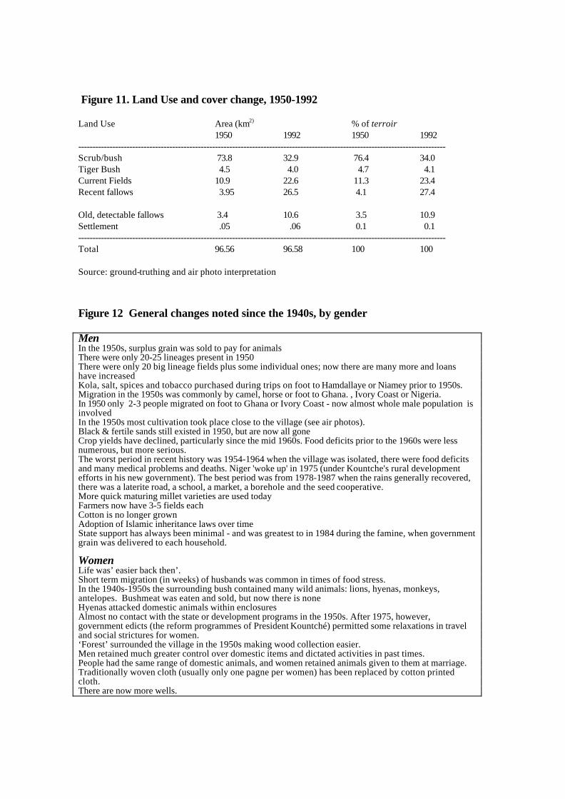
Figure 11. Land Use and cover change, 1950-1992
Land Use Area (km2) % of terroir1950 1992 1950 1992
---------------------------------------------------------------------------------------------------------------------------------Scrub/bush 73.8 32.9 76.4 34.0Tiger Bush 4.5 4.0 4.7 4.1Current Fields 10.9 22.6 11.3 23.4Recent fallows 3.95 26.5 4.1 27.4
Old, detectable fallows 3.4 10.6 3.5 10.9Settlement .05 .06 0.1 0.1---------------------------------------------------------------------------------------------------------------------------------Total 96.56 96.58 100 100
Source: ground-truthing and air photo interpretation
Figure 12 General changes noted since the 1940s, by gender
MenIn the 1950s, surplus grain was sold to pay for animalsThere were only 20-25 lineages present in 1950There were only 20 big lineage fields plus some individual ones; now there are many more and loanshave increasedKola, salt, spices and tobacco purchased during trips on foot to Hamdallaye or Niamey prior to 1950s.Migration in the 1950s was commonly by camel, horse or foot to Ghana. , Ivory Coast or Nigeria.In 1950 only 2-3 people migrated on foot to Ghana or Ivory Coast - now almost whole male population isinvolvedIn the 1950s most cultivation took place close to the village (see air photos).Black & fertile sands still existed in 1950, but are now all goneCrop yields have declined, particularly since the mid 1960s. Food deficits prior to the 1960s were lessnumerous, but more serious.The worst period in recent history was 1954-1964 when the village was isolated, there were food deficitsand many medical problems and deaths. Niger 'woke up' in 1975 (under Kountche's rural developmentefforts in his new government). The best period was from 1978-1987 when the rains generally recovered,there was a laterite road, a school, a market, a borehole and the seed cooperative.More quick maturing millet varieties are used todayFarmers now have 3-5 fields eachCotton is no longer grownAdoption of Islamic inheritance laws over timeState support has always been minimal - and was greatest to in 1984 during the famine, when governmentgrain was delivered to each household.
WomenLife was’ easier back then’.Short term migration (in weeks) of husbands was common in times of food stress.In the 1940s-1950s the surrounding bush contained many wild animals: lions, hyenas, monkeys,antelopes. Bushmeat was eaten and sold, but now there is noneHyenas attacked domestic animals within enclosuresAlmost no contact with the state or development programs in the 1950s. After 1975, however,government edicts (the reform programmes of President Kountché) permitted some relaxations in traveland social strictures for women.‘Forest’ surrounded the village in the 1950s making wood collection easier.Men retained much greater control over domestic items and dictated activities in past times.People had the same range of domestic animals, and women retained animals given to them at marriage.Traditionally woven cloth (usually only one pagne per women) has been replaced by cotton printedcloth.There are now more wells.

Restrictions on trading and market selling were enforced in the old days. Milk, butter, and sauceingredients were sold by women past reproductive age only. Kola, salt and tobacco were purchasedduring trips on foot to Hamdallaye or Niamey.Donkey carts and trucks eased transportation and mobility after the 1960s.

Figure 13. Additional details on the agricultural system
All farmers in the sample survey used local millet varieties as their staple crop, with only twoin 1997 using improved varieties as well. Most intercrop millet with cowpea. Six (of 20)fields also contained hibiscus and two contained sesame - both crops solds for cash.Intercropping was universally regarded as a method to minimise the spread of pest attacks,particularly on cowpea, and as a minimal source of soil improvement from cowpea stover.Intercropping patterns are not static over time, although most farmers learned their presentcrop mixes and planting strategies from their parents. One farmer changed his planting patternafter participating in the seed multiplication project of the 1980s. Fields sizes generally varybetween 1-6 ha-1. As the following table shows, fertilisers have not been applied in recentyears due to availability and cost, but were used extensively during the lifetime of the seedproject (prior to 1987).
Fertiliser and manure applications by year (numbers of fields; n=20)
Chemical fertiliser applied Manure applied1997 none 61996 none 41995 none 41994 none 41993 none 41992 none 4
1991 2 6
1990 2 4
1989 2 51988 2 5
1987 8 6
1986 6 5

1985 8 5
1984 3 5
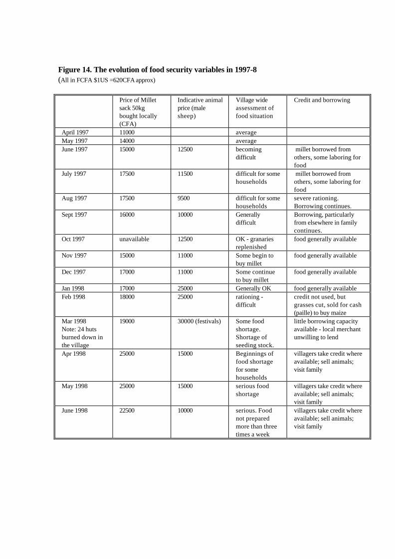
Figure 14. The evolution of food security variables in 1997-8(All in FCFA $1US =620CFA approx)
Price of Milletsack 50kgbought locally(CFA)
Indicative animalprice (malesheep)
Village wideassessment offood situation
Credit and borrowing
April 1997 11000 averageMay 1997 14000 averageJune 1997 15000 12500 becoming
difficult millet borrowed fromothers, some laboring forfood
July 1997 17500 11500 difficult for somehouseholds
millet borrowed fromothers, some laboring forfood
Aug 1997 17500 9500 difficult for somehouseholds
severe rationing.Borrowing continues.
Sept 1997 16000 10000 Generallydifficult
Borrowing, particularlyfrom elsewhere in familycontinues.
Oct 1997 unavailable 12500 OK - granariesreplenished
food generally available
Nov 1997 15000 11000 Some begin tobuy millet
food generally available
Dec 1997 17000 11000 Some continueto buy millet
food generally available
Jan 1998 17000 25000 Generally OK food generally availableFeb 1998 18000 25000 rationing -
difficultcredit not used, butgrasses cut, sold for cash(paille) to buy maize
Mar 1998Note: 24 hutsburned down inthe village
19000 30000 (festivals) Some foodshortage.Shortage ofseeding stock.
little borrowing capacityavailable - local merchantunwilling to lend
Apr 1998 25000 15000 Beginnings offood shortagefor somehouseholds
villagers take credit whereavailable; sell animals;visit family
May 1998 25000 15000 serious foodshortage
villagers take credit whereavailable; sell animals;visit family
June 1998 22500 10000 serious. Foodnot preparedmore than threetimes a week
villagers take credit whereavailable; sell animals;visit family
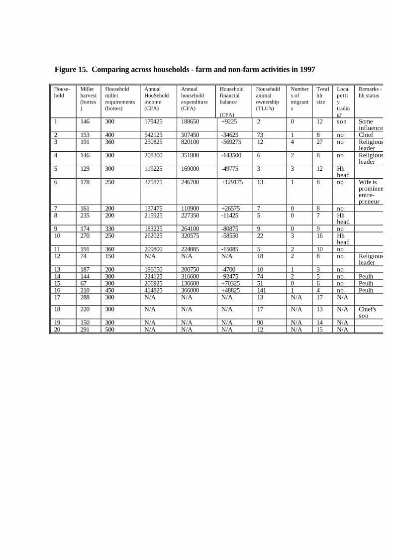
Figure 15. Comparing across households - farm and non-farm activities in 1997
House-hold
Milletharvest(bottes)
Householdmilletrequirements(bottes)
AnnualHouSeholdincome(CFA)
Annualhouseholdexpenditure(CFA)
Householdfinancialbalance
(CFA)
Householdanimalownership(TLU's)
Numbers ofmigrants
Totalhhsize
Localpetttytrading?
Remarks -hh status
1 146 300 179425 188650 +9225 2 0 12 son Someinfluence
2 153 400 542125 507450 -34625 73 1 8 no Chief3 191 360 250825 820100 -569275 12 4 27 no Religious
leader4 146 300 208300 351800 -143500 6 2 8 no Religious
leader5 129 300 119225 169000 -49775 3 3 12 Hh
head6 178 250 375875 246700 +129175 13 1 8 no Wife is
prominententre-preneur
7 161 200 137475 110900 +26575 7 0 8 no8 235 200 215925 227350 -11425 5 0 7 Hh
head9 174 330 183225 264100 -80875 9 0 9 no10 270 250 262025 320575 -58550 22 3 16 Hh
head11 191 360 209800 224885 -15085 5 2 10 no12 74 150 N/A N/A N/A 18 2 8 no Religious
leader13 187 200 196050 200750 -4700 10 1 3 no14 144 300 224125 316600 -92475 74 2 5 no Peulh15 67 300 206925 136600 +70325 51 0 6 no Peulh16 210 450 414825 366000 +48825 141 1 4 no Peulh17 288 300 N/A N/A N/A 13 N/A 17 N/A
18 220 300 N/A N/A N/A 17 N/A 13 N/A Chief'sson
19 150 300 N/A N/A N/A 90 N/A 14 N/A20 291 500 N/A N/A N/A 12 N/A 15 N/A
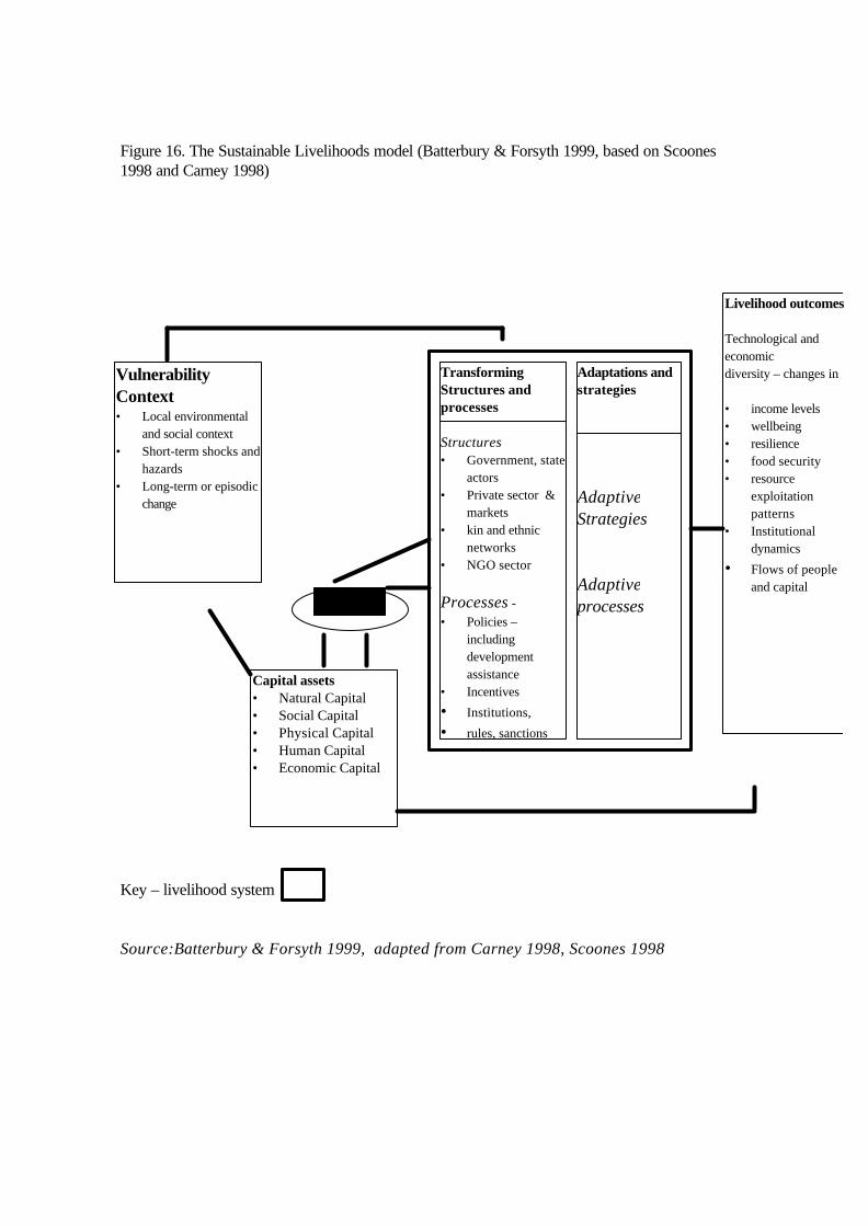
Figure 16. The Sustainable Livelihoods model (Batterbury & Forsyth 1999, based on Scoones1998 and Carney 1998)
Key – livelihood system
Source:Batterbury & Forsyth 1999, adapted from Carney 1998, Scoones 1998
VulnerabilityContext• Local environmental
and social context• Short-term shocks and
hazards• Long-term or episodic
change
Capital assets• Natural Capital• Social Capital• Physical Capital• Human Capital• Economic Capital
TransformingStructures andprocesses
Structures• Government, state
actors• Private sector &
markets• kin and ethnic
networks• NGO sector
Processes -• Policies –
includingdevelopmentassistance
• Incentives
• Institutions,
• rules, sanctions
Adaptations andstrategies
AdaptiveStrategies
Adaptiveprocesses
Livelihood outcomes
Technological andeconomicdiversity – changes in
• income levels• wellbeing• resilience• food security• resource
exploitationpatterns
• Institutionaldynamics
• Flows of peopleand capital
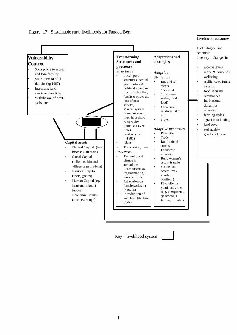
1
Figure 17 : Sustainable rural livelihoods for Fandou Béri
Key – livelihood system
VulnerabilityContext• Soils prone to erosion
and lose fertility• Short-term rainfall
deficits (eg 1997)• Increasing land
shortage over time• Withdrawal of govt.
assistance
Capital assets• Natural Capital (land,
biomass, animals)• Social Capital
(religious, kin andvillage organisations)
• Physical Capital(tools, goods)
• Human Capital (eg.farm and migrantlabour)
• Economic Capital(cash, exchange)
TransformingStructures andprocessesStructures• Local govt.
structures, centralgovt .policy &political economy(loss of schooling,fertiliser prices up,loss of extn .service)
• Market system• Some intra and
inter-householdreciprocity(atomised overtime)
• Seed scheme(>1987)
• Islam• Transport systemProcesses -• Technological
change inagriculture
• Extensification,fragmentation,more animals
• Relaxation onfemale seclusion(>1970s)
• Introduction ofland laws (the RuralCode)
Adaptations andstrategies
AdaptiveStrategies• Buy and sell
assets• Seek credit• Short term
saving (cash,food)
• Move/visitrelatives (shortterm)
• prayer
Adaptive processes• Diversify• Trade• Build animal
stocks• Economic
migration• Build women’s
assets & trade• Secure land
access (mayinvolveconflict!)
• Diversify hhyouth activities(e.g. 1 migrant; 1@ school; 1farmer; 1 trader)
Livelihood outcomes
Technological andeconomicdiversity – changes in
• income levels• indiv. & household
wellbeing• resilience to future
stresses• food security• remittances• Institutional
dynamics• migration• farming styles• agrarian technology• land cover• soil quality• gender relations

2
4. Dissemination
Research is already being disseminated to various audiences through participation in workshops,presentations, and papers. These are listed here, and some are included as Appendices. Wefirst presented our work in-country at ICRISAT in March 1995 during the Starter phase, andhave discussed findings and methods with the national agricultural service INRAN, and withseveral NGOs and academics during several subsequent field visits to Niger. Many academicpresentations have been made in Britain, Europe, and the USA. Several academic papers havebeen published or are in press, and the project has appeared as a case study in a policydocument for the British aid agency, DFID. Lastly, we organised a major international conferencein London to provoke wider debate and interest in these issues drawing from Sahelian andEuropean expertise.
In terms of future work (in the present absence of funding for fieldwork) we envisage FandouBéri as a 'case study' that may improve understanding of the Sahelian environment, and the datacollected may feed into future projects. For example, data has been shared with Henny Osbahr'sclosely related ESRC-funded PhD research on livelihoods and soils. Our GIS system is beingcompared with that of a neighbouring village, Banizoumbou, by ICRISAT in Niamey. Data willbe soon be made available to IoH for research into decision-support systems. Dr Len Milich ofArizona State University has included Niger in a proposal to investigate climate predictors anddrought in the Sahel. Prof Clive Agnew is working with Dr Adrian Chappell and Prof. Warren onwater-balance modelling and Sahelian climate.
The project web site is http://www.lse.ac.uk/depts/destin/simon/serida.html, and the major findingswill be posted there.
Advice to policymakers
In 1999, the UK Department for International Development (DFID) published this book:
Scoones, I and C Toulmin. 1999. Policies for Soil Fertility Management in Africa. DFID issues series,London: Department for International Development. 128Pp.
In addition to reviewing and advising on soil management policy in Africa, the book developed ananalysis of recommendations for different production systems using fifteen cases of researchprojects across the continent. Fandou Béri was included as a case in Appendix 5, and discussedas an example of a "low rainfall site experiencing difficulty" along with other research cases inZimbabwe and Mali. It was noted that in this case,
"...all cultivable land is around the village is now cultivated, and there is little fallow land available.Low inherent potential of the soils, combined with limited access to livestock, mean that levels of soilfertility are low. Where livestock manure is available, yields can be substantially improved...Accessto markets is not particularly poor...but yields and returns are not sufficient to provide muchincentive to intensify. All sites rely heavily on migration for remittances which further limitsinvestment of labour effort in conservation and soil enhancing practices, much of which must be
3
done during the dry season.Off farm incomes are important as a supplement to poor crop yields, andinclude collection of firewood, trading and various craft activities...prospects for this kind of farmingsystem depend greatly on their being able to find crops with a sufficient profit margin to enableinvestment in purchased inputs, as a supplement to organic sources. The high level of out-migrationmay make it difficult to intensify the system through heavy inputs of labour, hence the need to relyon a mix of inorganic and organic inputs."(Scoones & Toulmin 1999:54-55).
In addition a proposal has recently been submitted to the ESRC to convene a series of sixworkshops on "Transformations in African Agriculture: natural resources, livelihoods andmarkets". These meetings would involve academics, DFID and NGO policymakers in discussionof the main challenges facing African agrarian systems over the next two years.
We were less successful in disseminating this research in Niger, since results have becomeavailable after ESRC funding ended. Villagers have been appraised of project activities, severaldiscussions and meeting were held in Niamey with NGOs, and some scientific collaborationcontinues.
International Conference Organised
Simon Batterbury and Andrew Warren convened "The African Sahel: Twenty-five years afterthe great drought" at the Royal Geographical Society, London, in May 1998. There were 175delegates, and eight speakers; Claude Raynaut (Bordeaux), Mike Hulme (UEA), Jean MarieCour (Club du Sahel), Gaoussou Traoré (CILSS), Mike Mortimore, J.J.Rob Groot(Wageningen), Brigitte Thébaud and Camilla Toulmin (IIED). The following day, a 50-persontechnical meeting chaired by S. Batterbury and C. Toulmin assessed the past, current andpotential linkages between research into natural resources and socio-economic change in theSahel, and brought together African and European policymakers and donors to discuss policyissues. Agricultural transformations, and our project, were discussed and documents wereexchanged. Several African scholars attended including Drs. Mamman (Sokoto), Ouedraogo(Ouagadougou) and Amanor (Legon, Ghana) and the aid agencies DFID, Caisse Francaise andDANIDA. This workshop was addressed by Roy Stacy, Director of the OECD's Club du Sahel.The meeting was widely praised, and received funding (£5,960) from the Department forInternational Development's West and North Africa Department, plus support from IIED'sdrylands programme.
A report was produced:
Batterbury, SPJ. 1998. The African Sahel 25 Years After The Great Drought : Assessing ProgressAnd Moving Towards New Agendas and Approaches. 28Pp + 50pp research summaries.http://www.brunel.ac.uk/depts/geo/sahelrep.html
It summarizes the papers, key findings, and possibilities for future collaboration. This is alsoavailable on the internet, and reports features in The Geographical Journal, Haramata, andEnvironmental Conservation. The journal Disaster Prevention and Management featuredthe site and gave it an award (see http://www.mcb.co.uk/portfolio/dpm/issues/008001/net.htm#37)

4
Alister Scott of ESRC-GEC attended and wrote resumés of the presentations, which were allpublished on the DFID/IDS "ID21" web site /email information service (http://ww.id21.org). Asummary appeared in the ESRC-GEC Newsletter.
Papers by each of the presenters, and an additional introduction and a paper on soil erosionresearch, have been submitted for consideration as a special issue of Global EnvironmentalChange as follows (Fandou Béri is discussed in the ninth paper, and Nigerien rural issues inseveral):
1.) Simon Batterbury and Andrew Warren “The African Sahel 25 Years After The Great Drought:Assessing Progress And Moving Towards New Agendas And Approaches “2.) Claude Raynaut “Societies And Nature In The Sahel : Ecological Diversity And SocialDynamics”3.) Mike Hulme “Sahelian Desiccation 1973-1998”4.) Jean Marie Cour “The Sahel In West Africa: Countries In Transition To A Full Market Economy”5.) Gaoussou Traoré “Is the Sahel prepared to take up the challenges of the 21st century?”6.) Mike Mortimore and Bill Adams “ Farmers Adapting to Drought “7.) Henk Breman J.J.Rob Groot, and Herman van Keulen “Resource Limitations In SahelianAgriculture”8.) Brigitte Thébaud “Sahel Pastoralists 25 Years After The Drought”9.) Andrew Warren Simon Batterbury “ Soil Erosion In The Sahel Of West Africa”
Dissemination to scientific, academic, and policy audiences through articles andchapters
The following papers have been produced to date:
Batterbury, S.P.J. 1996 "The Sahel of West Africa: a place for Geographers?" Geography 81 (4) (No. 353): 391-395. (Audience: educators. Compares Fandou Béri with sites in Burkina Faso)
Batterbury, SPJ, Taylor, VNH , M Weigl. 1997. "Security and Change in Southwestern Niger" DevelopmentResearch Insights (IDS, Sussex) 21:2 (audience: policymakers.http://www.ids.ac.uk/ids/publicat/insights/feb97.html)
Chappell, A.fc. The limitations for measuring soil redistribution using 137Cs in semi-arid environments.Geomorphology (based on NERC funded PhD research in Fandou Béri)
Chappell, A., 1998. Mapping 137Cs-derived net soil flux using remote sensing and geostatistics. Journal ofArid Environments, 39: 441-455. (based on NERC funded PhD research in Fandou Béri)
Chappell, A. 1996. Modelling the spatial variation of processes in the redistribution of soil: digital terrainmodels and 137Cs in southwest Niger. Geomorphology 17: 249-261. (based on NERC funded PhD research inFandou Béri)
Chappell, A. and Oliver, M.A. 1997. Geostatistical analysis of soil redistribution in SW Niger, West Africa. InE.Y. Baafi and N.A. Schofield (Eds) Quantitative Geology and Geostatistics, Volume 8/2. Pp961-972. Kluwer.(based on NERC funded PhD research in Fandou Béri)
Chappell, A., Oliver, M.A., Warren, A., Agnew, C.T. & Charlton, M. 1996. Examining the factors controllingthe spatial scale of variation in soil redistribution processes from southwestern Niger. In Anderson, M.G. &Brooks, S.M. (eds.) Advances in Hillslope Processes pp 429-449. Chichester: John Wiley. (partially based onNERC funded PhD research in Fandou Béri)

5
Chappell, A., Oliver, M.A., and Warren, A. 1996. Net soil flux derived from multivariate soil propertyclassification, SW Niger: a quantified approach based on 137Cs. In B. Buerkert, B.E. Allison, and M. vonOppen (Eds) Wind Erosion in West Africa: The Problem and its Control. pp. 69-85. Margraf Verlag,Weikersheim, Germany. (based on NERC funded PhD research in Fandou Béri)
Chappell, A., Valentin, C., Warren, A., Charlton, M.d'Herbés, J.-M. 1997. Testing the validity of upslopemigration in banded vegetation from south-west Niger Catena.
Chappell, A., Warren, A. Oliver, M.A. and Charlton, M. 1998. The utility of 137Cs for measuring soilredistribution rates in south-west Niger. Geoderma , 81, (3-4): 313-338 (based on NERC funded PhD research inFandou Béri)
Chappell, A, Warren A., V.N.H Taylor, and M. Charlton. 1998 "Soil Flux (Loss and Gain) in SouthwesternNiger and Agricultural Impact." Land Degradation and Development 9: 295-310.
Longbottom, J. C 1996. From SOAS to Niger: Reflections on learning and doing anthropology. Anthropologyin Action: Journal for Applied Anthropology in Policy 3 (2): 38-41
Warren, A. 1998. Land Degradation in the Sahel: Some Observations. In Reenberg, A, H Marcussen & I.Nielsen (Eds.)Sahelian Perspectives - Myths and Realities . SEREIN Occasional Paper No 6. pp1-12.Copenhagen: Institute of Geography.
Warren, A. 1998. Environmental science and desertification at the frontier, in The arid frontier: interactivemanagement of environment and development, Eds. Bruins, H.J. and Lithwick, H., Kluwer, Dordrecht, 117-127.
Warren, A & Batterbury, SPJ. Submitted. “Soil Erosion in the Sahel of West Africa: A Review of ResearchIssues and an Assessment of New Approaches” Special Issue on the Sahel, Global Environmental Change(Dec2001)
Other publications and unpublished material
Batterbury, SPJ with Longbottom, J.C. 1996. Social and Environmental Change in a Village in SW Niger, 1900-1996. Unpublished paper, 28pp.
Batterbury, S.P.J and A Warren. 1996. "Approaches to Environmental History and Agricultural Change inSub-Saharan Africa." Workshop on Environmental and Economic Change: Understanding DynamicProcesses in Sub-Saharan Africa". UCL, CSERGE. January. Unpublished paper.
Batterbury, SPJ and Taylor, VNH. To be submitted. Zarma Livelihoods and African Environmental History:Studying 20th century social and environmental change in south-west Niger. Draft for Land Degradation andDevelopment
Batterbury, SPJ. submitted. A local Political Ecology of Livelihood Diversification in Semi-Arid West Africa(Niger). Draft for Ecumene
Batterbury SPJ, Warren A, Waughray D. 1996. “Social and Environmental Relationships, Land Use and LandDegradation in Southwestern Niger”. Starter Grant Report to the ESRC Global Environmental ChangeProgramme. 109pp.
Taylor, VNH, Weigl, M., Waughray D, Warren A, Batterbury SPJ. Field Coordinators Progress reports andfield trip reports. Various Dates, 1997 and 1998.
Warren, A, Osbahr, H et al. In progress. Summary paper on the social relations of land degradation.
Theses /dissertations completed and in progress

6
(these are not included for lack of space - copies are available on request)
Allen, C. 1997. Indigenous understanding of soil fertility and management issues in the Sahelian village ofFandou Béri , south-western Niger. MRes thesis, Environmental Science, University College London.
Chappell, A. 1995. Geostatistical Mapping and Ordination Analyses of 137CS-Derived Net Soil Flux inSouth-West Niger. PhD thesis. London: Department of Geography, University College London.
Longbottom, J.C. 1996. Productive Bricolage: Changing Livelihoods And Gendered Strategies In ResponseTo Food Insecurity In Southwest Niger. MA thesis, Social Anthropology of Development, School of Orientaland African Studies, University of London.
Matthew, S. 1998. The Development of a Soil Water Balance Model as an Efficient Tool for AgroclimaticResearch in the Sudano-Sahelian Zone. MRes thesis, Environmental Science, University College London.
Osbahr, H. 1997. Indigenous Knowledge, fallow systems and indicator species; a case study from FandouBéri Southwestern Niger. MRes thesis, Environmental Science, University College London.
Osbahr, H. In progress, 1997-2000. Livelihood strategies and soil fertility in Fandou Béri, south-westernNiger. PhD in Geography, University College London. (ESRC funded)
Piper, T. 1998. An Investigation into the Effect of Algal Crusts on Soil Fertility in the Sahelian village ofFandou Béri, southwest Niger. MRes thesis, Environmental Science, University College London.
Presentations:
Batterbury, SPJ. 1996. Sahelian Livelihoods in Transition: Social and Environmental Change in SouthwesternNiger. Research Seminar Series, African Studies Centre, University of Cambridge. Invited seminar. November.
Batterbury, SPJ. 1997. Social and Environmental Change in the West African Sahel (Niger and Burkina Faso).African Societies in Transition Series, Department of Geography, University of Oxford. Invited seminar.January.
Batterbury, SPJ. 1998. Rural Development and the Environment in West Africa: Geographers Learning from Farmers. Institute of Education, University of London.October.
Batterbury, SPJ. 1999. Political Ecology, Scale and Time: development and environmental change in Africa.Colloquium Series, Maxwell School of Citizenship and Public Affairs, Department of Geography, SyracuseUniversity, USA. March 2nd.
Batterbury, SPJ. 1999. Political Ecology, Scale and Time: development and environmental change in Africa.Colloquium Series, Department of Geography, University of Minnesota, USA. Feb 5Th.
Batterbury, SPJ. 1999. Political Ecology, Scale and Time: Re-encountering Development and UnderstandingEnvironmental Change in Africa. Colloquium Series, Department of Geography, University of Kentucky, USA.25Th Jan.
Batterbury, SPJ. 1999. A Political Ecology of Livelihood Diversification in Semi-Arid West Africa (Niger).Presented at international session on 'Livelihoods and landscapes in transition: cultural and politicalecologies of contemporary rural change', Association of American Geographers meetings, Honolulu, Hawai'i,March.

7
Batterbury, S.P.J. 1999. Project presentation at 'African Environments: Technology, Modeling, and PoliticalEcology' . Invited panellist, expert workshop of African, European and American scholars, fully funded bythe National Science Foundation. University of Kansas , USA, September 8-11.
Batterbury, S.P.J. 1999. Political Ecology, Environmental History. Learning from studies of environmentalchange in West Africa. Inaugural lecture series, Centre for Earth and Environmental Science Research,Kingston University, 28th April.
Batterbury, S.P.J. 2000. Reflections on Methodological Complexity: Lessons from South-West Niger. Topresent at international session on 'Mixed Landscapes, Mixed Methods', Association of AmericanGeographers meetings, Pittsburgh, USA, April.
Batterbury, SPJ and Taylor, VNH. 1998. Zarma Livelihoods and African Environmental History: Studying 20Th
century social and environmental change in south-west Niger. Presented at international session on 'Accessto resources/environmental history', Association of American Geographers meetings, Boston, USA, April.
Batterbury, SPJ and Warren, A. Nov 1996. Social and Environmental Change in SW Niger. ESRC GlobalEnvironmental Change participants workshop, Hamilton House, London. ESRC event.
Batterbury, SPJ and Warren, A. 1997. Project presentation. Meeting with SEREIN, Institute of Geography,University of Copenhagen. March.
Batterbury, S.P.J, Warren A & Osbahr, H. 1999. Zarma Livelihoods: Social and Environmental Change in the20Th Century In South-west Niger. Presented at the conference on 'African Environments Past and Present,' StAntony's College, Oxford University, June.
Rendell, H.M., Clarke, M.L., Warren, A., Chappell, A. and Taylor, N. 1998. Episodic sand movement in westernNiger. International Conference on Aeolian Research (ICAR-4), July, Oxford (Abstracts, p66).
Osbahr, H. and Allen, C. 1997. Research Presentations. ICRISAT, Sadoré.
Osbahr, H. 2000. Livelihood Strategies and soil fertility in Fandou Béri, south-western Niger. Association ofAmerican Geographers meetings, Pittsburgh, USA, April.
Warren, A. Jan 1997. Dry Science. Inaugural lecture, Professor of Geography, UCL
Warren, A. 1997. British Council lectures on land degradation. University of Khartoum, Sudan.
Warren, A. 1998. Land Degradation in the Sahel: Some Observations. The Danish Sahel Workshop, January,Sönderborg, Denmark.
Warren, A. 1999. Project presentation: sustainability, soils, and dryland farming. Department of Geography,University of Bergen, Norway. September.
Warren, A. 1999. Sustainability in the Sahel. Department of Geography seminar series, UCL, November.
Warren, A. 2000. What do we need to know about Soil Erosion in the Sahel? Presented at Association ofAmerican Geographers meetings, Pittsburgh, USA, April 2000.
Warren, A and Chappell, A. 1997. Soil Flux in Niger and Its Agricultural Impact. 50Th anniversary meeting atthe Wind Erosion Unit (USAD), Kansas State University, Manhattan Kansas, May.
Warren A., Taylor, N. 1997. Field Histories in semi-arid Niger. Workshop on Sustainable Livelihoods inMarginal Environments, 10-11 April, Univ. of Sheffield. ESRC event.
Proposals

8
Workshop Organised
8. Major Difficulties
• Personnel issues - The loss of our Co-PI Dominic Waughray and his skills inenvironmental economics, was not foreseeable. This meant that the economic componentof the study has been downscaled. In addition, and in order to compensate for this,additional fieldwork was carried out in 1998, and the RA worked beyond the end of hiscontract to improve quality and accuracy of our dataset. Micha Weigl's anthropologicalexpertise was lost to the project in late 1997.
• A GIS system has been developed that links to the large socio-economic and agriculturaldatabase collected for Fandou Béri. Although it now works well, it has taken beyond theend of the project to design and make use of this system for representing spatial patternsand key variables, given the long learning curve involved for the project team.
• Niger’s political situation remained in flux throughout the lifetime of the project. Wehave seen two military coups in 1996 and 1999, and the country awaits a democraticallyelected government. The economic crisis continues. Occasional difficulties - corruption,minor hostility and the usual logistical breakdowns were experienced. International aiddisbursements to Niger have been strongly affected by the political situation, and our planto continue working in the village in 1999-2000 in cooperation with a developmentproject or donor therefore looked less and less likely as time went on.
• In addition, partly as a result of its location in Niger, our research host - ICRISAT - haschanged its operations in Niger and is moving many facilities and staff to Mali or furtherafield. This affected our plans for dissemination and future collaboration. Like some otherCGIAR centres, they have faced severe cutbacks. ICRISAT's scientific personnel hasbeen reduced, and non-scientific staff have been laid off, amidst strikes and animosity atthe time.
• In Fandou Béri, considerable data were collected through a combination of scientific,qualitative and quantitative investigations and we tried to rise to the challenge of inter-disciplinary work. Our mode of operation from the outset has been to conduct 'hybrid'and multi-method investigations at a single site, and only later did we focus in on themultiple dimensions of key 'processes' (such as soil erosion, or agriculturaldecisionmaking). We lacked, therefore, an initial organisational 'theory' to guide datainterpretation. With hindsight, interpreting the patterns coming out of the large economicand social dataset has posed significant challenges that a narrowed, more closelytargetted investigation may not have faced to the same extent.
• We have not been able to obtain continued funding for a further fieldwork phase. It wasnot possible to approach the EC in 1996 and 1997, for example, because of their stanceon the military regime in Niger. Niger is not a DFID priority country. We were not

9
included in the Desert Margins Program organised by ICRISAT and INRAN, which hasreceived some international funding. But efforts to attract additional funding to continuethe work have been partially successful, with the award of money for disseminationthrough the Sahel conference, and for six student projects in the village (one funded bythe ESRC - Appendix 2).