land ownership map cr-1 crazies geographic area
TRANSCRIPT

66
9271
8926
8918
47C50
66
Copyright:© 2013 National Geographic Society, i-cubed
Ü0 2 41
Miles
Crazies Geographic Area BoundaryOwnership
National Forest SystemPrivateWater
Land OwnershipCrazies Geographic Area
Spring 2020Helena - Lewis and Clark National Forest2020 Forest Plan
Map CR-1

&3
&3
¬«294
Twodot
Martinsdale
£¤89
£¤12
UpperAmerican
Fork
Upper BigElk Creek
MuddyCreek
CottonwoodCreek
MillerCreek
LittleElk Creek
Bozeman ForkMusselshell
River
West ForkCottonwood
Creek
CombCreek
Upper South ForkMusselshell River
Potter
Creek
Shields River
NorthFork Mus selshellRiver
Sixteenmile C reek
Middle Fork American
Fork
Fish Creek
Haymaker CreekMart i nsda l e Reservo
ir
L ittle Elk Creek
Co ttonwood Creek
Sou thF ork MusselshellRiver
Bozeman ForkMusselshell River
Big Elk Creek
American Fork
Sweet Grass Creek
MartinsdaleReservoir
LeboLake
Ü0 4 82
Miles
Crazies Geographic Area BoundaryMajor StreamsLakes/Reservoirs
Watershed Condition ClassFunctioning ProperlyFunctioning at Risk
WatershedsCrazies Geographic Area
Spring 2020Helena - Lewis and Clark National Forest2020 Forest Plan
Map CR-2

66
9271
CR-01
CR-02
8926
8918
47C50
66
Ü0 2 41
Miles
Crazies Geographic Area BoundaryNon-National Forest System LandLynx Analysis UnitPotential Lynx Habitat
Lynx Analysis Units and Potential HabitatCrazies Geographic Area
Spring 2020Helena - Lewis and Clark National Forest2020 Forest Plan
Map CR-3

66
9271
8926
8918
47C50
66
Ü0 2 41
Miles
Crazies Geographic Area BoundaryNon-National Forest System Land
Desired Recreation Opportunity SpectrumSemi-Primitive Non-MotorizedSemi-Primitive MotorizedRoaded Natural
Desired Recreation Opportunity SpectrumCrazies Geographic Area
Spring 2020
Helena - Lewis and Clark National Forest2020 Forest Plan
Map CR-4
66
9271
8926
8918
47C50
66
Ü0 2 41
Miles
Crazies Geographic Area BoundaryNon-National Forest System Land
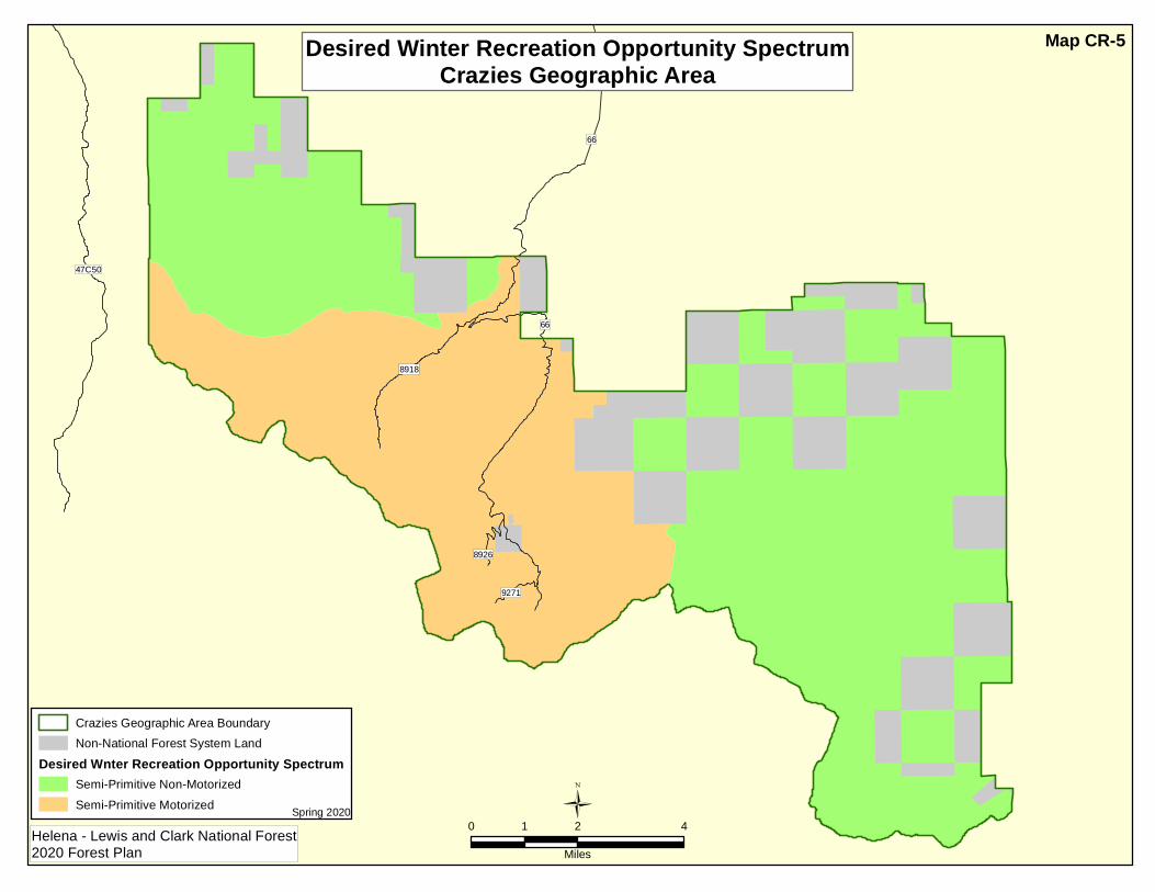
Desired Wnter Recreation Opportunity SpectrumSemi-Primitive Non-MotorizedSemi-Primitive Motorized
Desired Winter Recreation Opportunity SpectrumCrazies Geographic Area
Spring 2020Helena - Lewis and Clark National Forest2020 Forest Plan
Map CR-5

66
9271
8926
8918
47C50
66
Ü0 2 41
Miles
Crazies Geographic Area BoundaryNon-National Forest System Land
Scenic Integrity ObjectivesHighModerateLow
Scenic Integrity ObjectivesCrazies Geographic Area
Spring 2020Helena - Lewis and Clark National Forest2020 Forest Plan
Map CR-6

66
9271
8926
8918
47C50
66
Ü0 2 41
Miles
Crazies Geographic Area BoundaryOther National Forest System LandNon-National Forest System Land
Inventoried Roadless AreasCrazy MountainsBox Canyon
Inventoried Roadless AreasCrazies Geographic Area
Spring 2020Helena - Lewis and Clark National Forest2020 Forest Plan
Map CR-7
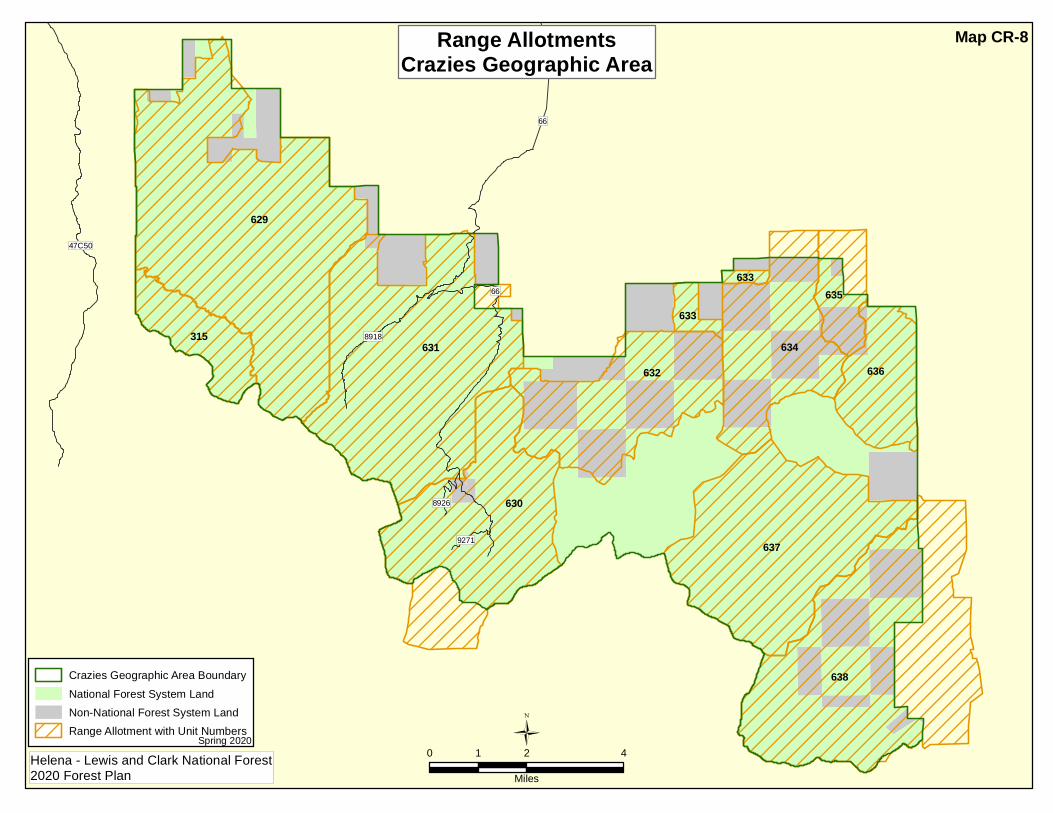
66
634
633
633
636
638
315
630
631632
635
629
6379271
8926
8918
47C50
66
Ü0 2 41
Miles
Crazies Geographic Area BoundaryNational Forest System LandNon-National Forest System LandRange Allotment with Unit Numbers
Range AllotmentsCrazies Geographic Area
Spring 2020Helena - Lewis and Clark National Forest2020 Forest Plan
Map CR-8

66
47C50
66
Ü0 2 41
Miles
Crazies Geographic Area BoundaryNon-National Forest System LandInventoried Roadless AreaLands Suitable For Timber ProductionLands Unsuitable For Timber Production Where Harvest Could Occur
Lands Where Harvest Could OccurCrazies Geographic Area
Spring 2020Helena - Lewis and Clark National Forest2020 Forest Plan
Map CR-9