land management and natural hazards unit - unipr.it · land management and natural hazards unit 20...
TRANSCRIPT

Land Management and Natural Hazards Unit 1
Land Management and Natural Hazards UnitGuido Schmuck (Head of Unit)
http://ies.jrc.ec.europa.eu/the-institute/units/land-management-and-natural-hazards-unit.html
Land Management and Natural Hazards Unit 2
To support EU policies and programs linked to sustainable land management practices in the fields of forestry, soils and weather-driven natural hazards
with a particular focus on
the development of environmental information systems
The unit directly supports European policies in the fields of Environment and Sustainability, Forestry and Soils, Regional Development, and Civil Protection
Mission
Land Management and Natural Hazards Unit 3
ActivitiesForestry
Establishment of the European Forest Data Centre - a single focal point for forest data and information for the Commission
Customers: DG ENV*, DG AGRI**, DG REGIO***, DG ENTR****, EEA*****, Forest services in Member States
SoilEstablishment of the European Soil Data Centre - a single focal point for soil data and
information for the Commission Customers: DG ENV, DG AGRI, EEA
Desertification, Land Degradation and DroughtsDevelopment of tools for the implementation of policies and conventions related to drought
and desertification in Europe and worldwide.Customers: DG ENV, DG DEV******, DG REGIO, DG AGRI, DG EuropAid
Natural HazardsDevelopment of a better capacity for early warning, monitoring and damage assessment
systems for weather-driven natural hazards, as well as for tools for assessing climate change effects, land use change effects, risk mapping and adaptation to extreme events
Customers: DG ENV, DG REGIO, DG ENTR, EEA, National hydrological and meteorological services
*Environment, **Agriculture, ***Regional Policy, ****Enterprise and Industry, ***** European Environment
Agency, ****** Development

Land Management and Natural Hazards Unit 4
Forestry
International organisations:Ministerial Conference for the Protection of Forests in Europe (MCPFE)Food and Agriculture Organisation of the United Nations (FAO) United Nations Economic Commission for Europe (UNECE) International Co-operative Programme on Assessment and Monitoring of Air Pollution Effects on Forests (ICP Forests) United States Department of Agriculture - Forest Service (USDA-Forest Service)United States Environment Protection Agency (US-EPA)
Research organisations:Over 50 research organisations (on e.g. forestry, forest fire modelling, remote sensing, information systems, socio-economic analysis, climate change, emissions)
Land Management and Natural Hazards Unit 5
±
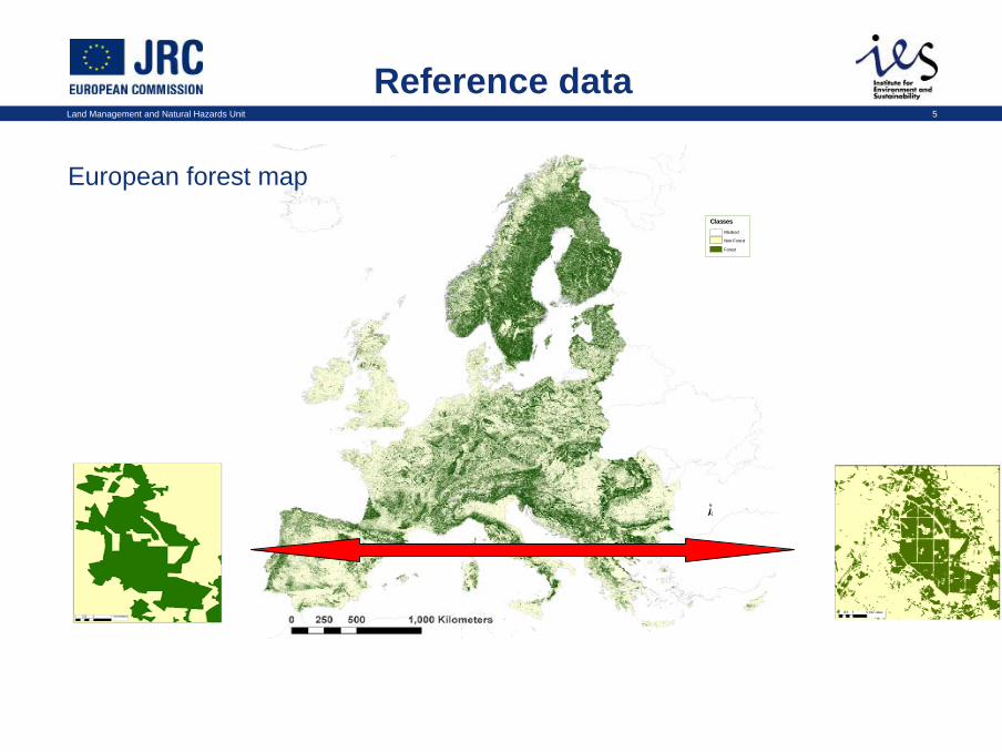
ClassesMasked
Non-Forest
Forest
Reference data
European forest map
Land Management and Natural Hazards Unit 6
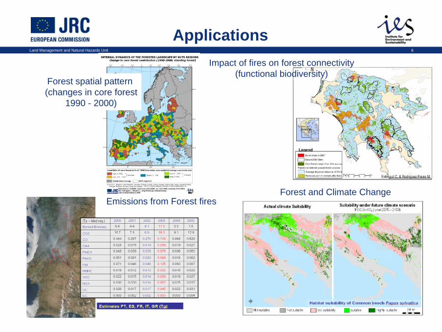
Emissions from Forest firesForest and Climate Change
Applications
Forest spatial pattern (changes in core forest
1990 - 2000)
Impact of fires on forest connectivity (functional biodiversity)
Land Management and Natural Hazards Unit 7
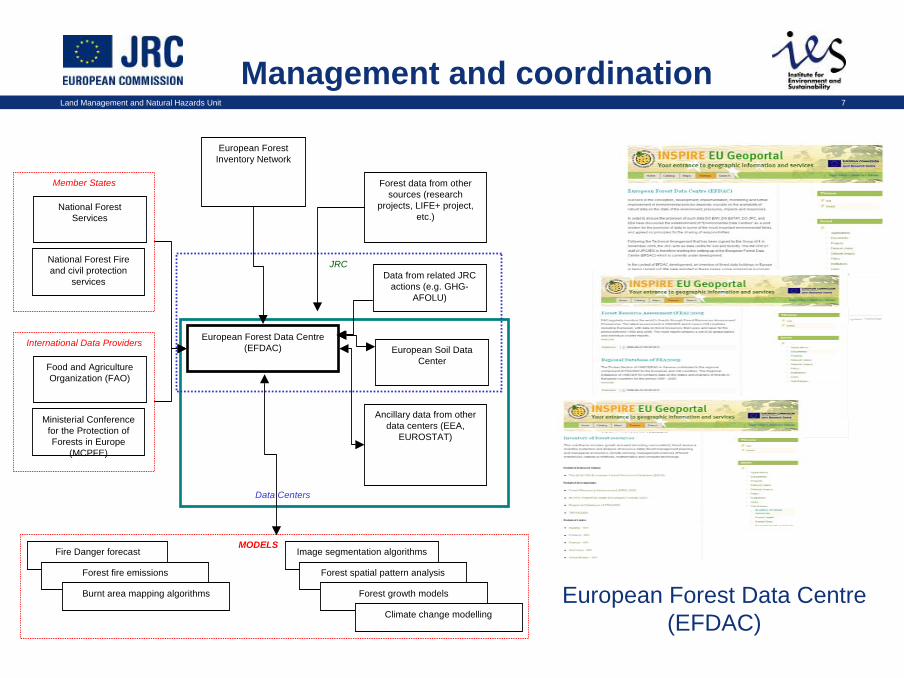
Management and coordination
Data Centers
JRC
European Forest Data Centre(EFDAC)
European Forest Inventory Network
Forest data from other sources (research
projects, LIFE+ project, etc.)
Data from related JRC actions (e.g. GHG-
AFOLU)
European Soil Data Center
Ancillary data from other data centers (EEA,
EUROSTAT)
National Forest Services
National Forest Fire and civil protection
services
Member States
European Forest Data Centre(EFDAC)
Food and Agriculture Organization (FAO)
Ministerial Conference for the Protection of Forests in Europe
(MCPFE)
International Data Providers
Fire Danger forecast
Forest fire emissions
MODELS
Burnt area mapping algorithms
Image segmentation algorithms
Forest spatial pattern analysis
Forest growth models
Climate change modelling
Land Management and Natural Hazards Unit 8
SoilInternational organisations:Food and Agriculture Organisation of the United Nations (FAO) United States Department of Agriculture – Soil Conservation ServiceAustralia's Commonwealth Scientific and Industrial Research Organisation (CSIRO) United Nations Environment Programme (UNEP) United Nations Convention on Biological Diversity (UNCBD)African Soil Science Society (ASSS)European Confederation of Soil Science Societies (ECSSS) European Environment Agency (EEA) European Society for Soil Conservation (ESSC) International Soil Reference and Information Centre (ISRIC) International Union of Soil Sciences (IUSS) International Soil Conservation Organisation (ISCO)Soil and Water Conservation Society (SWCS)
Research organisations:Within Europe, collaboration with national soil survey organisations, leading universities and research institutes, soil science experts is carried out through the JRC’s European Soil Bureau Network. Currently around 80 organisations are members of the foremost network of soil experts in Europe

Land Management and Natural Hazards Unit 9
Reference Data
European soil map

Land Management and Natural Hazards Unit 10
Topsoil Organic Carbon Content
Soil Erosion Risk
Soil Crusting
Wind Erosion Risk
Organic Carbon (%) No Data 0 - 1 1 - 2 2 - 5 5 - 10 10 - 25 25 - 35 > 35
Applications
Land Management and Natural Hazards Unit 11
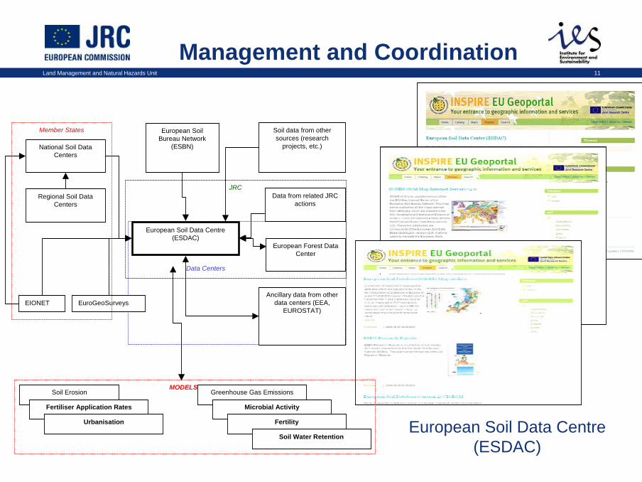
Management and Coordination
Data Centers
JRC
European Soil Data Centre(ESDAC)
European Soil Bureau Network
(ESBN)
Soil data from other sources (research
projects, etc.)
Data from related JRC actions
European Forest Data Center
Ancillary data from other data centers (EEA,
EUROSTAT)
National Soil Data Centers
Regional Soil Data Centers
EIONET EuroGeoSurveys
Member States
European Soil Data Centre(ESDAC)
Soil Erosion
Fertiliser Application Rates
MODELS
Urbanisation
Greenhouse Gas Emissions
Microbial Activity
Fertility
Soil Water Retention
Land Management and Natural Hazards Unit 12
Natural Hazards
International organisations:European Centre for Medium Range Weather Forecast (ECMWF)International River Basin Commissions (IKSO - Oder, IKSE - Elbe, IKSD/ICPDR - Danube)World Meteorological Organisation (WMO)
Research organisations:Bristol University (UK)Bundesanstalt für Gewässerkunde (BfG, DE)Delft Hydraulics (NL)University of Utrecht (NL)University of Washington State, Seattle (USA)

Land Management and Natural Hazards Unit 13
ForecastingEuropean Forest Fire Information System
(EFFIS)
European Flood Alert System(EFAS)
European Drought Observatory(EDO)
Platform for drought detection, monitoring, forecasting, and information exchange
• Commonly agreed products • Multi-scale approach,
integrating • Subsidiarity principle

Land Management and Natural Hazards Unit 14
FIRE RISK CLASSIFICATIONRisk Class
LOW
MEDIUM
HIGH
NO FIRE DATA
Risk Mapping
Floods
Forest Fires
Risk = hazard * exposure * vulnerability

Land Management and Natural Hazards Unit 15
Future risk under climate change conditions
Research:Estimated change in potential flood damage of a 100-year flood for SRES* A2 scenario
Underlying data/models:- 12 km A2 scenario DMI- LISFLOOD model setup- SRTM DEM** - CORINE*** landcover- damage curves countries
* Special Report on Emissions Scenarios, ** Shuttle Radar Topography Mission Digital Elevation Database, ***Coordination of the Information on the Environment

Land Management and Natural Hazards Unit 16
Damage assessment
Forest Fires and NATURA 2000 sitesFloods and industrial installations
Land Management and Natural Hazards Unit 17
Desertification
International organisations:
• United Nations Convention to Combat Desertification (UNCCD)• United Nations Environment Programme/Division of Global Environment Facility Coordination (UNEP/GEF)• United Nations University – International Network on Water, Environment & Health (UNU- INWEH)• Consultative Group on International Agricultural Research (CGIAR, ICARDA/ICRISAT Centres)
Research organisations:
• DesertNet International (Network of Global Desertification Research Institutions, 283 members from 47 countries)• Nucleo di Ricerca di Desertificazione (NRD) (Sassari, Italy)• Estación Experimental de Zonas Aridas (CSIC) (Almeria, Spain)• More than 30 universities and research centres in Europe, NW-Africa, Asia and S-America as partners incompetitive research projects

Land Management and Natural Hazards Unit 18
Examples of basic input data
Vegetation Cover
Bio-physical &
socio-economic
datasets
Land Surface Albedo
Dominant Soil Types
Global Land Cover
Population & Trends (WRI)
Cattle Densities (FAO)
Land Management and Natural Hazards Unit 19
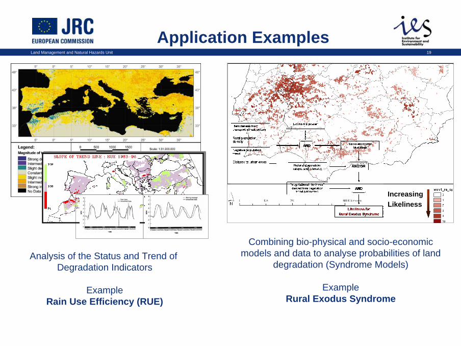
Application Examples
Analysis of the Status and Trend of Degradation Indicators
ExampleRain Use Efficiency (RUE)
IncreasingLikeliness
Combining bio-physical and socio-economic models and data to analyse probabilities of land
degradation (Syndrome Models)
ExampleRural Exodus Syndrome

Land Management and Natural Hazards Unit 20
Management and coordination
Land degradation and desertification
Food Security
Climate Change
Marine Resources& Fisheries
Crisis Response& Humanitarian AidBiodiversity
Protection
Renewable Energies
Vulnerability Assessment
Natural RisksReduction
Illegal Mining and Logging
Land degradation and desertificationLand degradation and desertification
Food SecurityFood Security
Climate Change
Marine Resources& Fisheries
Marine Resources& Fisheries
Crisis Response& Humanitarian Aid
Crisis Response& Humanitarian AidBiodiversity
ProtectionBiodiversity Protection
Renewable Energies
Renewable Energies
Vulnerability AssessmentVulnerability Assessment
Natural RisksReduction
Natural RisksReduction
Illegal Mining and Logging
Illegal Mining and Logging
Assessment and mapping
EU – Africa Partnerships
UNCCD
Desertification, Land Degradation, Drought
ONLINE PORTAL
Data & Information
DLD-IS*
* DLD-IS: Desertification, Land Degradation, and Drought Information System
Benchmarks &Indicators
Global Monitoring and Assessment
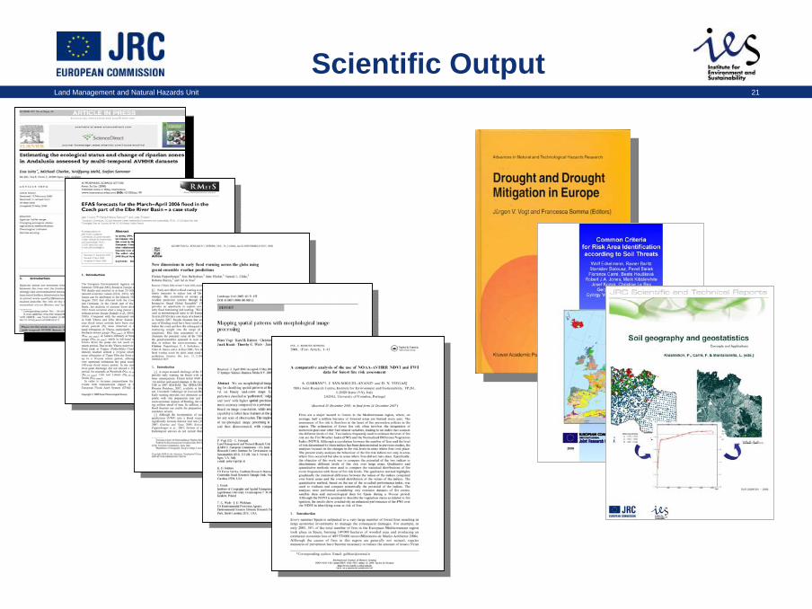
Land Management and Natural Hazards Unit 21
Scientific Output
JRC Ispra - IES1
Monitoraggio dei suoli in Europa e Metalli Pesanti
Parma, 30 settembre 2008
Ciro Gardi, Luca Montanarella, Luis Rodríguez-Lado
Sistemi informativi – Analisi e Gestione del Territorio
JRC Ispra - IES2
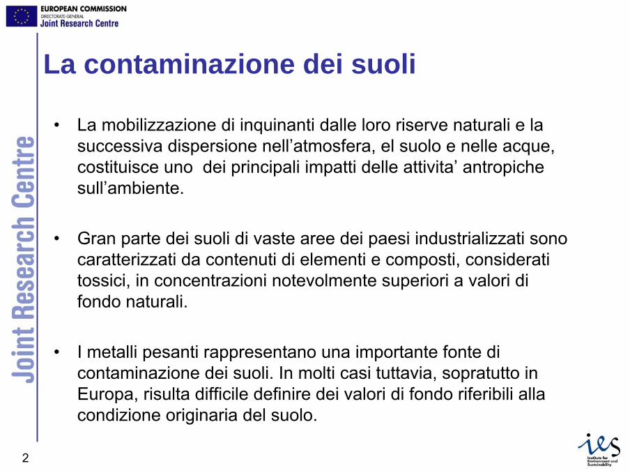
La contaminazione dei suoli
• La mobilizzazione di inquinanti dalle loro riserve naturali e la successiva dispersione nell’atmosfera, el suolo e nelle acque, costituisce uno dei principali impatti delle attivita’ antropichesull’ambiente.
• Gran parte dei suoli di vaste aree dei paesi industrializzati sonocaratterizzati da contenuti di elementi e composti, consideratitossici, in concentrazioni notevolmente superiori a valori difondo naturali.
• I metalli pesanti rappresentano una importante fonte dicontaminazione dei suoli. In molti casi tuttavia, sopratutto in Europa, risulta difficile definire dei valori di fondo riferibili allacondizione originaria del suolo.

JRC Ispra - IES3
La Strategia Tematica per il Suolo
• Il suolo è praticamente una risorsa naturale non rinnovabile, e svolge funzioni cruciali per le attività umane e gli ecosistemi
• Proposta di direttiva quadro sul suolo (COM(2006)232 definitivo,22.9.2006)
• La protezione del suolo e la conservazione delle sue capacità di svolgere una qualsiasi delle seguenti funzioni ambientali, economiche, sociali e culturali:
– produzione di biomassa, in particolare nei settori dell’agricoltura e della silvicoltura;
– stoccaggio, filtrazione e trasformazione di nutrienti, sostanze e acqua;
– riserva di biodiversità, ad esempio habitat, specie e geni;
– ambiente fisico e culturale per le persone e le attività umane;
– fonte di materie prime;
– stoccaggio di carbonio;
– sede del patrimonio geologico e archeologico.
JRC Ispra - IES4
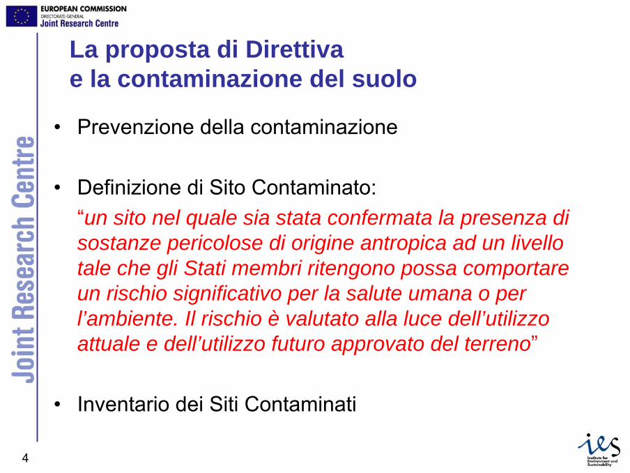
La proposta di Direttivae la contaminazione del suolo
• Prevenzione della contaminazione
• Definizione di Sito Contaminato: “un sito nel quale sia stata confermata la presenza di sostanze pericolose di origine antropica ad un livello tale che gli Stati membri ritengono possa comportare un rischio significativo per la salute umana o per l’ambiente. Il rischio è valutato alla luce dell’utilizzo attuale e dell’utilizzo futuro approvato del terreno”
• Inventario dei Siti Contaminati

JRC Ispra - IES5
Le concentrazioni di riferimento di metallipesanti nei suoli Europei• Geochemical baseline ≠ background value
• Attivita’ iniziata nel 1997 da 26 Stati Membri, con ilcoordinamento del FOREGS (Forum of European Geological Surveys)
• Il prodotto finale e’ costituito dall’Atlante Geochimicod’Europa
JRC Ispra - IES6
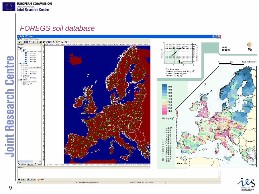
Elaborazioni sul Dataset FOREGS
• 1558 punti relativi a campioni di suolo
• Concentrazioni di As, Cd, Cr, Cu, Hg, Ni, Pb e Zn
• Estrazione con Acqua Regia (tranne mercurio)
• Analisi con ICP-AES (tranne mercurio)
• Utilizzazione di variabili ausiliarie nel processo diinterpolazione
JRC Ispra - IES7
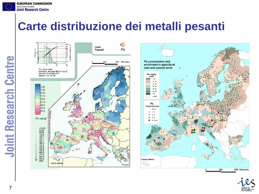
Carte distribuzione dei metalli pesanti
JRC Ispra - IES8
Perche’ la geostatistica?
• Consente di ottenere stime obiettive:– della concentrazione dei metalli– della incertezza associata
• Offre la possibilita’ di utilizzare un numeroelevato di variabili ausiliarie (predittive)
• Consente di effettuare stime accurate delleconcentrazioni di metalli pesanti nel suolo.
• Le procedure possono essere automatizzate (R scripts)
JRC Ispra - IES9
FOREGS soil database
JRC Ispra - IES10
Variabili obiettivo
• 8 metalli pesanti nel suolo:– As, Cd, Cr, Cu, Hg, Ni, Pb, Zn
JRC Ispra - IES11
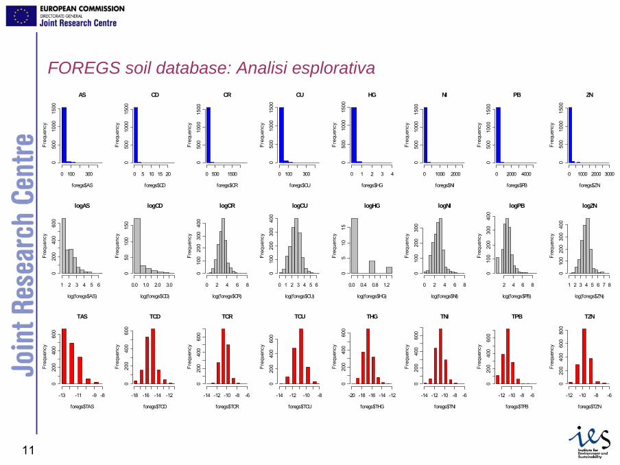
FOREGS soil database: Analisi esplorativaAS
foregs$AS
Freq
uenc
y
0 100 300
050
010
0015
00
CD
foregs$CD
Freq
uenc
y
0 5 10 15 20
050
010
0015
00
CR
foregs$CRFr
eque
ncy
0 500 1500
050
010
0015
00
CU
foregs$CU
Freq
uenc
y
0 100 300
050
010
0015
00
HG
foregs$HG
Freq
uenc
y
0 1 2 3 4
050
010
0015
00
NI
foregs$NI
Freq
uenc
y
0 1000 2000
050
010
0015
00
PB
foregs$PB
Freq
uenc
y
0 2000 4000
050
010
0015
00
ZN
foregs$ZN
Freq
uenc
y
0 1000 2000 3000
050
010
0015
00
logAS
log(foregs$AS)
Freq
uenc
y
1 2 3 4 5 6
020
040
060
0
logCD
log(foregs$CD)
Freq
uenc
y
0.0 1.0 2.0 3.0
050
100
150
logCR
log(foregs$CR)
Freq
uenc
y
0 2 4 6 8
010
020
030
040
0logCU
log(foregs$CU)
Freq
uenc
y
0 1 2 3 4 5 6
010
020
030
040
0
logHG
log(foregs$HG)
Freq
uenc
y
0.0 0.4 0.8 1.2
05
1015
logNI
log(foregs$NI)
Freq
uenc
y
0 2 4 6 8
010
020
030
0
logPB
log(foregs$PB)
Freq
uenc
y
2 4 6 8
010
020
030
040
0
logZN
log(foregs$ZN)
Freq
uenc
y
1 2 3 4 5 6 7 8
010
020
030
040
0
TAS
foregs$TAS
Freq
uenc
y
-13 -11 -9 -8
020
040
060
0
TCD
foregs$TCD
Freq
uenc
y
-18 -16 -14 -12
020
040
060
0
TCR
foregs$TCR
Freq
uenc
y
-14 -12 -10 -8 -6
020
040
060
0
TCU
foregs$TCU
Freq
uenc
y
-14 -12 -10 -8
020
040
060
0
THG
foregs$THG
Freq
uenc
y
-20 -18 -16 -14 -12
020
040
060
0
TNI
foregs$TNIFr
eque
ncy
-14 -12 -10 -8 -6
020
040
060
0
TPB
foregs$TPB
Freq
uenc
y
-12 -10 -8 -6
020
040
060
0
TZN
foregs$TZN
Freq
uenc
y
-12 -10 -8 -6
020
040
060
080
0

JRC Ispra - IES12
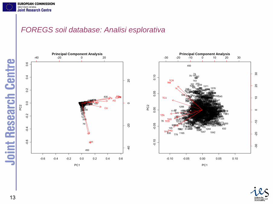
FOREGS soil database: Analisi esplorativa
logAS
log(foregs$AS)
Freq
uenc
y
1 2 3 4 5 6
020
040
060
0
logCD
log(foregs$CD)
Freq
uenc
y
0.0 1.0 2.0 3.0
050
100
150
logCR
log(foregs$CR)
Freq
uenc
y
0 2 4 6 8
010
020
030
040
0
logCU
log(foregs$CU)
Freq
uenc
y
0 1 2 3 4 5 6
010
020
030
040
0
logHG
log(foregs$HG)
Freq
uenc
y
0.0 0.4 0.8 1.2
05
1015
logNI
log(foregs$NI)
Freq
uenc
y
0 2 4 6 8
010
020
030
0
logPB
log(foregs$PB)
Freq
uenc
y
2 4 6 8
010
020
030
040
0
logZN
log(foregs$ZN)
Freq
uenc
y
1 2 3 4 5 6 7 8
010
020
030
040
0
TAS
foregs$TAS
Freq
uenc
y
-13 -11 -9 -8
020
040
060
0
TCD
foregs$TCD
Freq
uenc
y
-18 -16 -14 -12
020
040
060
0
TCR
foregs$TCR
Freq
uenc
y-14 -12 -10 -8 -6
020
040
060
0
TCU
foregs$TCU
Freq
uenc
y
-14 -12 -10 -8
020
040
060
0
THG
foregs$THG
Freq
uenc
y
-20 -18 -16 -14 -12
020
040
060
0
TNI
foregs$TNI
Freq
uenc
y
-14 -12 -10 -8 -6
020
040
060
0
TPB
foregs$TPB
Freq
uenc
y
-12 -10 -8 -6
020
040
060
0
TZN
foregs$TZN
Freq
uenc
y
-12 -10 -8 -6
020
040
060
080
0
TAS = ln(ASstand/1-ASstand)
ASstand= (AS-ASmin)/(ASmax-ASmin)
JRC Ispra - IES13
-0.10 -0.05 0.00 0.05 0.10-0
.10
-0.0
50.
000.
050.
10
Principal Component Analysis
PC1
PC
2 1
23
4
5
6
7
8
9
10
11
12 13
14
15
1617
18
19
20
21
222325
26
2728
29
3031
35
3637
3839
40 4142
44
4546 47
48
49
50 51
52
5354
55
56
57
58
59
6061
62
63 64
65
6667
68
6970 7172
73
74
75
76
77
78
79
80
81
82
83
8485
86
87
88
8990
9192
93
9495
96
97
98
99
100
101102
104
105
106
107
108
109
111112113114
115
116118
119
120
121
122
123
124 125
126128129
130
131
132133134
135
136
137
138
139
140141
142143
144145146
147
148
149150
151
152
153
154
155
156 157
158
159
160161
162 163
164
165166167168
169 170171
172173
176
178
179
180181
182
183184
185
186187
188
189190
191
192194
195
196
197
198199200
201202
203204
205
206
207
208
209210
211
212
213214220
223
224
226
227
228229
230
231 232
233
234235
236
237
238
239240 241
242243244
245
246247
248
250
251
252
253
254255
256
257
258
259
260
261
262
263264
265266
267269 270271
272
274
275
276 277
278279
280
281
284
286287 289
291292
293294
295
296297
298
299
300
301302
303
304
305
306
307
308
309
310311
312313
314
315
316
317
318
319
320
321322323
324325
326
327328
329
330
331
333
334
335
336
337
338
339
340
341
342
343344
345346
347
348
349
350
351
352353
354
355
356357
358360
362
363
364
365
366
367
368
369
370
373375
376377378379380381382
383
384385386
387
388
389
390391
392
393
394
396397
398
399
400
401
402403404405 406
407408409410411
412413414
415
416
417418
419
420
421
422
423424425
426427428
429
430
431432
433
434
435
436437
438
439
440
441
442
443
444445
446
447
448
449
450
451
452
453454
455
456
457458
459
460
461462
463
464
465
466
467
468
469470
471
472 473
474475476
477478
479480481482
483
484485
486487
488
489
490
491
492
493
494
495
496497
498499 500
501
502
503504
505
506
507508
509
510
511
512
513
514
515516
517518
519520
521
522
523
524
525
526527
528
529
530531
532
533
534
535536
537538
539
540
541542543544545546547
548
549
550551
552
553554555556557
558
559560
561562563
564
565
566
567
568569 570
571
572
573574575
576
577
578
579
580581
582
583
584
585
586
587588
589
590
591
592
593
594
595
596597
598599600601
602
603604
605
606607608
609
610
611612
613
614
615
616
617618
619
620621
622
623
624
625
626
627
628
629
630
631
632
633
634
635636
637
638
639
640
641642
643
644645646
647
648
649650651
652653654
655
656
657658
659660
661662
663
664
665666
667
668 669670
671
672
673
674675
676677
678
679680681 682
683
684
685
686
687688 689690691
692693
694
695696
697
698699
700
701
702703
705706
707709
710
712
713714
715716
717
718719
720721
722
723724
725
726
727
728
729730
731732
733
734735
736
737 738
739
740741 742743
744745
746
747
748
749
750
751
752
753754
755
756
757758
759
760761762
763
764
765766
767
768
769770
771
772
773
774 775
776 777
778
779
780 781782783784
785
786
787
788
789
790791
792
793
794
795
796 797
798799
800
801
802
803
804
805806807
808
809810
811
812
813814
815
816
817818
819820822
823824
825
826
827
828
829
830
831
832
833
834
835
836
837
838839
840
841
842843
844
845
846
847
848
849850851
852853
854
855856
857858
859
860861
862863864
865
866
867
868
869
870871
872873
874
875876877
878
879
880
881882
883
884
885
886
887888889
890891
892
893894895896
897
898
899900
901
902
903904
905
906
907
908
909910
911912913914
915
916
917
918
919920
921
922
923
924
925
926
927
928
929930
931932933
934935
936
937
938939940
941942
943
944945
946947948 949
950
951952
953954
955956
957958
959
960
961 962963 964
965
966967968
969970
971
972973
974
975
976977978979980
981982
983
984985
986
987988989
990
991992993
994995
9979989991000
1001
100210031004
10051006
1007
1008
100910101011
1012
1013
10141015
101610171018
10191020
1021
1022
1023
10241025
10261027
1028
1029
1030
1031103210331034 10351036
10371038
10391040
1041
1042
1043
10441045
1046
1047
1048
1049
1050 1051
105210531054
10551056
1057 1058
1059
10601061
1062
1063
1064
1065
1066
10671068
1069
1070
10711072
107310741075
1076
1077
1078
107910801081
1082
1083
10841085
1086
1087
1088
10901091
1092
1093
10941095
1096
10971098
1099
1100
1101
11021103
1104
1105
11061107
11081109
1110
1111
1112
1113
1114
1115
1116
1117111811191120
1121 1122
1123
1124
11251126
1127
1128
1129
1130
113111321133 1134
113511361137
11381139
1140
11411142
1143
1144
1145
1146
1147
1148
1149
1150
1151
1152
1153115411561157
11581159 11601161
11621163
1164
1165
1166
1167
1168
1169
1170
11711172
1173
1174 1175
1176 1177
11781179
1180
11811182
118311851186
1187
11881189
1190
11911192
1193
11941195
1196
1197
11981199
1200
12011202
1203
1206
12071208
120912111212
1213
1214
12151216
1217
1218
121912201221
122212231224
12251226
1227
1228
12291230
1231
123212331234
1235 12361237
1238
1239
12401241
1242
1243
1244
1245
1250
12511252 12531257
12581259
12601261
1262
126312641265
1266
1267 1268
1269
1270
1271127212731274
1275
12761277
1278
1279
1280
1281
12821283
1284
12851286
1287
12881289 1290
1291
1292
12931294
1295
1296
1297
1298
1299
1300
1301 1302
1303
130413071308
1309
1313
13141315
1317131813191320
132113221323
13241325
13261327
13281329
1330
1331
133213331334
1335
1336133713381339
1340
1341
1342
1343
13441345
1346
1347
1348
1349
1350
1351
13531355
13561357
135813591362
1363
1364
1365
1366
1367
13681369
1370
1371137213731374
13751376
1377
1378
1379
13801381
1382
1383
13841385
1386
1387
138813891390
13911392
13931394
1395
1396
1397
1398
1399
1402
1403
14041405
1406
14101411
14121413
1414
14151416
1417
1418
1419
14201421
1422
14231424
1425
1426
1427
14281429
143014311432
14331434
1435143614371438
1439
144014411442
1443
14441445
14461447
1448
1449
1450145114521453
1454
1455
1456
1457
1459
1461
1462
1463 146614671471147214731474
14751476 1477
1478
14791480
1481
1482
1483
14841485
14861487
14881489
14901491
1492
1493
1497
1498
1499
1503
1504
1505
15061507
15081509
1510151115121513
1514
1515
15161517
15181519
1520
15241525
15261530
1531 1532
1533
1534
15351536
1537
1538
1539
1540
1541
15421543
1544
1545
1546
15471548
15491550
155315541555
15561557
1558
1559
1560
15611562
15631564
1565
15661567
156815691570
1571
157215731574
1575 1576
1577
1578
157915801581
1582
1583
15841585
15861587
1588
-30 -20 -10 0 10 20 30
-30
-20
-10
010
2030
TASTCD
TCR
TCU
THG
TNI
TPB
TZN
FOREGS soil database: Analisi esplorativa
-0.6 -0.4 -0.2 0.0 0.2 0.4 0.6
-0.6
-0.4
-0.2
0.0
0.2
0.4
0.6
Principal Component Analysis
PC1
PC
2
12345678910111213141516171819
20212223252627282930313536373839404142444546474849505152535455565758
59
606162636465666768
6970
7172
73
74
75
76
77
78
79
80 81
82
83848586
87
888990919293949596979899100101102104 105106107108109111112113114 115116118119120121122 123124125126128129130131132133134135136137138139140141
142143
144145146
147
148149150151152153154155156
157158159160
161162163164165166167168169170171172173176178179180181182183184185186187188189190191192194195
196197198199200201202203204205206207208209210211212213214220223224226227228229230231232233234235236237238239240241242243244245246247
248
250251252 253254255256257258259260261262263264265266267269270271272274275276277278279280281284286287289291292293294295296297
298299300301302303304305306307308309310311312313314315316317318319320321322323 324325326327328329330331333334335336337338339340341
342
343344345346347348349350351352 353354355356357358360362363364365366367368369370373375376377378379380381382383384385386387388389390391392393394396397398399400401402403404405406407408409410411412413414415416417418419420421422423424425426427428429430431432433434
435436437438439440441
442443444445
446447448449
450
451452453454455456457458459460461462463464465466467468469470471472473474475476477478479480481482483484485486487488489490491492493494495496497498499500501502503504505506507508509510511512513
514515516517518519520521522523524525526527528529530531532533534535536537538539540541542543544545546547548549550551552553554555556557
558
559560561562563564565566567568569570571572573574575576577578579580581582583584585586587588589590591592593594595596597598599600601602603604605606607608609610611612613614615616617618619620621622623624
625
626627628629630631632633634635636637638639640641642643644645646647648649650651652653654655656657658659660661662663664665666667668669670671672673674675676677678679680681682683684685686687688689690691692693694695696697698699700701702703705706707709710712713714715716717718719720721722723724725726727728729730731732733734735736737738739740741742743744745746747748749750751752753754755756757758759
760761762763764765766767768769770 771772773774775776777778
779780781782783784785786787788 789790791792793794795796797798799800801802803804805806807808809810811812813814815816817818819820822823824825826827828829
830
831832833834835836837838839840841842843844845846847848849850851852853854855856857858859860861862863864865866867868869870871872873874875876877878879880881882883884885886887888889890891892893894895896897898899900901902903904905906907908909910911912913914915916917918 919920921922923924925926927928929930931932933934935936937938939940941942943944945946947948949950951952953954955956957958959960
9619629639649659669679689699709719729739749759769779789799809819829839849859869879889899909919929939949959979989991000100110021003100410051006100710081009101010111012 10131014101510161017101810191020102110221023102410251026102710281029103010311032103310341035103610371038103910401041104210431044 1045104610471048104910501051105210531054105510561057105810591060106110621063106410651066106710681069107010711072107310741075107610771078107910801081108210831084108510861087108810901091109210931094109510961097109810991100110111021103110411051106110711081109111011111112111311141115111611171118111911201121112211231124112511261127112811291130113111321133113411351136113711381139114011411142114311441145114611471148114911501151115211531154115611571158115911601161116211631164
11651166
116711681169117011711172117311741175117611771178117911801181118211831185118611871188118911901191119211931194119511961197119811991200120112021203
1206
1207120812091211121212131214121512161217121812191220122112221223122412251226122712281229123012311232123312341235
123612371238123912401241124212431244124512501251125212531257125812591260126112621263126412651266126712681269127012711272127312741275127612771278127912801281128212831284
1285128612871288128912901291129212931294129512961297129812991300130113021303130413071308130913131314131513171318131913201321132213231324132513261327132813291330133113321333133413351336133713381339134013411342134313441345134613471348134913501351135313551356135713581359136213631364136513661367136813691370137113721373137413751376137713781379138013811382138313841385138613871388138913901391139213931394139513961397139813991402140314041405140614101411141214131414141514161417141814191420142114221423142414251426142714281429143014311432143314341435143614371438143914401441144214431444144514461447144814491450145114521453145414551456145714591461146214631466146714711472147314741475147614771478147914801481148214831484148514861487148814891490149114921493149714981499150315041505150615071508150915101511151215131514151515161517151815191520152415251526153015311532153315341535153615371538153915401541154215431544154515461547154815491550155315541555155615571558155915601561156215631564156515661567156815691570157115721573157415751576157715781579158015811582158315841585158615871588
-40 -20 0 20
-40
-20
020
ASCD
CR
CU
HG
NI
PBZN

JRC Ispra - IES14
Regression-kriging
Regressione multipla lineare
Yj = a1 X1 + a2X2 + … + an Xn + εj
Variabileincognita j
residui j
Kriging
Yj
...
... ..... ...
.
. .. ..
..
∑ aiXii
.
..
...
. .. .. .. ..
γεj
distanza (m)
Sem
i-var
ianz
a
(processo di interpolazione realizzatosulla base dell’autocorrelazione tra le varibili)
Dati ausiliari i
Continue Puntuali
Somma tra le due carte
regressione
kriging
regression-kriging
Dati ausiliari
residui
Variabiliincognite

JRC Ispra - IES15
Variabili ausiliarie

JRC Ispra - IES16
Principal Component Analysis
PCA delle variabili ausiliarie
JRC Ispra - IES17
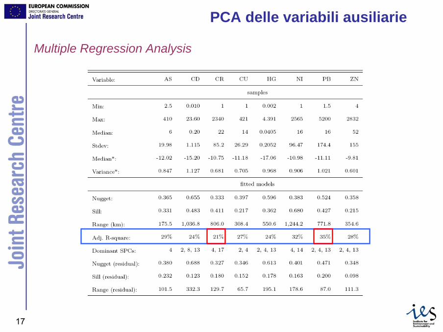
Multiple Regression Analysis
PCA delle variabili ausiliarie

JRC Ispra - IES18
Analisi della struttura spaziale: il semivariogramma

JRC Ispra - IES19
Risultati

JRC Ispra - IES20
Risultati: Pb

JRC Ispra - IES21
Confronto tra Kriging Ordinario e Regression Kriging
JRC Ispra - IES22
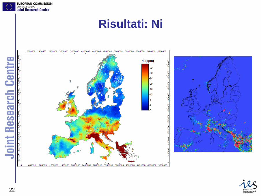
Risultati: Ni
JRC Ispra - IES23
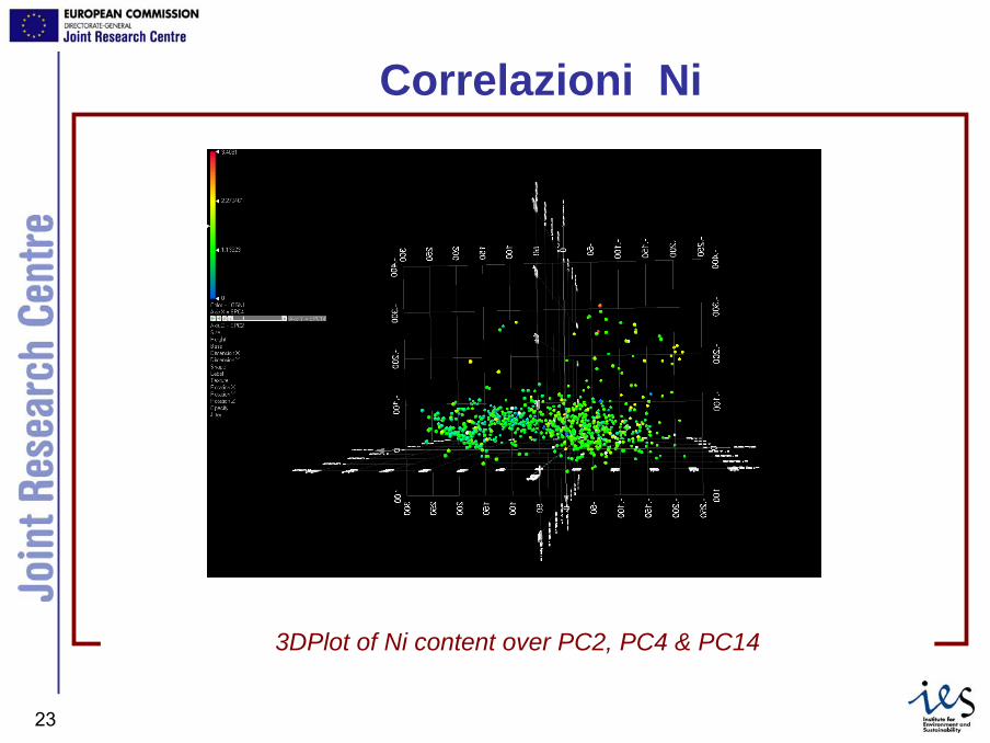
Correlazioni Ni
3DPlot of Ni content over PC2, PC4 & PC14
JRC Ispra - IES24
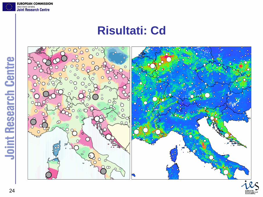
Risultati: Cd

JRC Ispra - IES25
Concentrazione complessiva di metalli in Europa
(1) Liege (Arrondissement) (BE), Attiki (GR), Darlington (UK), Coventry (UK), Sunderland (UK), Kozani (GR), Grevena (GR), Hartlepool & Stockton (UK), Huy (BE), Aachen (DE) (As, Cd, Cu, Hg and Pb)
(2) central Greece and Liguria region in Italy (Cr and Ni).
JRC Ispra - IES26
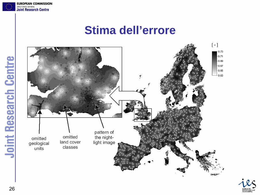
Stima dell’errore
JRC Ispra - IES27
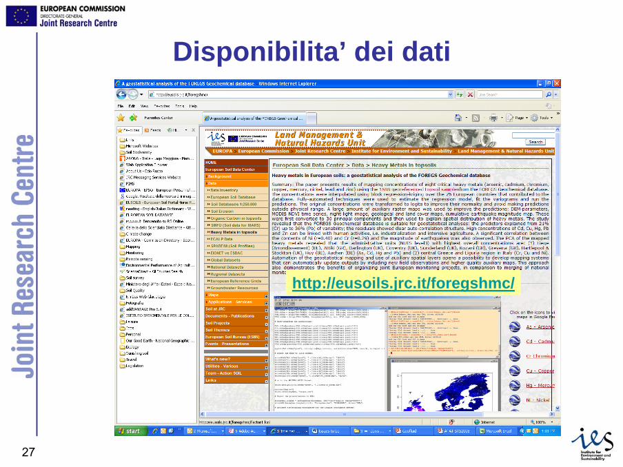
Disponibilita’ dei dati
http://eusoils.jrc.it/foregshmc/
JRC Ispra - IES28
Validazione
• Confronto tra Kriging Ordinario e Regression Kriging
• Abbastanza buono: Ni, Pb• Medio: As, Cd, Hg• Debole: Cr, Cu, Zn

JRC Ispra - IES29
Conclusioni• FOREGS e’ un esempio di dataset pan-
europeo idoneo all’applicazione di metodigeostatistici.
• In molti casi la distribuzione spaziale deimetalli pesanti e’ strettamente correlata ad altri fattori, quali geologia, urbanizzazione, copertura vegetale.

JRC Ispra - IES30
Conclusioni
• La disponibilita’ di cartografia di maggiordettaglio, relativa alle variabili ausiliarie, e di ulteriori dati, consentira’ di ottenererisultati piu’ accurati nel processo diinterpolazione spaziale:– Dati puntuali aggiuntivi– Basi di dati GIS
Luis Rodrguez Lado, Tomislav Hengl, Hannes I. Reuter.Heavy metals in European soils: a geostatistical analysis of the FOREGSGeochemical database, Geoderma (In Press)
JRC Ispra - IES31
Grazie per l’attenzione