land law and survey regulation (sghu 3313) · district land office to dsmm to perform final survey...
TRANSCRIPT
LAND LAW AND SURVEY REGULATION (SGHU 3313)
WEEK 15‐CADASTRAL SURVEY AND REGULATIONS (OFFICE)
SR DR. TAN LIAT CHOON07‐5530844016‐4975551
1

OUTLINE
• Office Practice
2

OFFICE PRACTICE
3
Deposited Plan
Section 410 of the National Land Code 1965 provides thedeposited plan that is a plan of the land shall be deposited if itis certified by the Director of Survey and Mapping as a validand properly plan for the land, with reference numberprovided by the State Director of Surveying and Mappingdated and kept in the State office.
According to Section 14 of the Land Surveyors Act 1958 (Act458), after survey fee deposited to the Board and the lotnumber applied by a licensed land surveyor from Departmentof Survey and Mapping, shall issue a lot after confirming thatpayment has been deposited with the Board.
4

Deposited Plan
After final survey, survey plan (e.g. certified plan) to besubmitted to the Department of Survey and Mapping,licensed land surveyor signed the certified plan shalldeposit the certified plan that together with field book,calculations sheet and survey data (in digital form) to theDepartment of Survey and Mapping within the time periodprescribed in the regulations. All documents shall, if theplan is approved by the Director General of Survey andMapping or other officer appointed by him, become theproperty of the Government and shall be filed as apermanent surveyed record.
5

Deposited Plan
If the work is not completed within the time period allottedin the regulation, the Board may instruct that the workundertaken by the Department of Survey and MappingMalaysia or other licensed land surveyors and survey feespaid in accordance with Section 28 of the Licensed LandSurveyor Regulations 2011.
6

Deposited Plan
Section 411 of the National Land Code 1965: Description of theland with reference to a deposited plan:
1) If:a) any land to be known in any written law or in any instrument,
notice or other documents published or made under,pursuant to or for the purposes of a written law; and
b) the exists of a deposited plan for land, it shall be sufficient ifthe land is known in the law, instruments, notices ordocuments with reference to the plan.
7

Deposited Plan
2) Subsection (1) of land known by reference to a depositedplan, the Minister (or an officer authorized by theMinister to act on his behalf for the purposes of thissubsection) may be ordered so many copies of the planas it deems appropriate shall be distributed to:
a) District Land office where the land is situated;b) Central registry of title to land in the State; andc) any officer and authorities as specified in the direction.
8

Deposited Plan
Section 412 of the National Land Code 1965: Copies ofdeposited plans.
For the purposes of this Chapter, every copy of the depositedplan shall:
a) issued in photography, photo‐lithography or any mechanicalor other processes which in itself ensure the accuracy of thecopy;
b) made by or on behalf of the Director of Survey and Mapping,which was deposited in his office; and
c) certified by or on its behalf as a valid and original copy.
9

Deposited Plan
In the proceedings, any document purporting to be acopy of the deposited plan:
a) shall be presumed until the contrary is proved; and
b) while it considered the case, shall be received inevidence without further proof as a legitimate andcorrect plan for the land to which it refers.
10

Requisition Survey Plan
Requisition Survey Plan is a basic plan that came along withthe application to survey to State DSMM to begin withpreparing the field survey for surveyor. It should show theparticulars lot to be surveyed as well as other relevantinformation. The details contained in the Requisition SurveyPlan is district/county/town, scales, Standard SheetNumber, Location Plan, Figure of lot to be surveyed, areserve either rivers, roads and so on, the position of theold boundary mark, lot number for adjacent lot, area,bearing and distance.
11

Requisition Survey Plan
Requisition Survey Plan is an application form issued by theDistrict Land Office to DSMM to perform final survey asrequired under Section 79 (1) and 83 of the National LandCode 1965.
Section 79 (1) of the National Land Code 1965:“Where any approval of the State Authority to the alienation ofland under this Act relates to land which (under sub‐section (2) ofsection 77) is required to be surveyed before it can be held underfinal title, it shall be given by reference to a plan and descriptionsufficient to enable the land and its boundaries to beprovisionally identified and ascertained pending the survey.”
12
Requisition Survey Plan
There are six types of requisition survey that is alienation ofGovernment Land, partition of Lot/Buildings, Amalgamationof Lot/Part and subdivision, and Surrender of Partial lot,acquisition of part of lot, and re‐survey of lot.
13

Requisition Survey PlanRequisition survey plan for approved land shall be providedsimultaneously with the issuance of qualified title. Draftsmanshall provide enough number of plans for the purpose ofapplication of Survey and Qualified Title. The following detailsmust be met:
i. The purpose of requisition survey and type of ownership,ii. Land area, bearing, distances and connection to boundaries
mark of the land to be surveyed,iii. Name, address and identification number landowner,iv. The State Executive Council approval, if required,v. Verification payment of survey fee, andvi. Reserved rivers, roads, buildings and other physical
characteristics . 14

Requisition Survey Plan
All query of requisition survey from DSMM shall beconveyed to the Chief Clerk through so that immediateaction can be taken. Solutions should be resolved and therequisition survey shall be sent back to the DSMM within aperiod of one month.
15

Requisition Survey Plan
District Land Office shall request DSMM separately forRequisition Survey involved with the difference in surveyunder section 83(3) of the National Land Code 1965.Reference from the State Director of Survey and Mapping toState Authority shall also be submitted simultaneously. Forpartial land affected by land acquisition, a separateRequisition Survey for the lots must be availablesimultaneously. For cases in which the Requisition Surveyapplication was made, then the original Requisition Surveyapplication shall be referred to DSMM.
16
Requisition Survey Plan
Besides the Requisition Survey application received fromthe District Land Office and the Land and Mines Office,DSMM also accept applications for conductingmeasurements from FELDA and JKPTG.
17

Registration and Management Survey files
Each Requisition Survey received should be registered intothe system according to categories such as survey for LandTitle, Strata Titles, Gazette and multi purpose. These dataare stored in the Registration Survey Database. This willallow the files supervised and monitored.
18

Registration File For Land Title Survey, Gazette And Multi Purpose
i. Registration begins when requisition survey for LandTitle Survey, Application for Gazette Survey andApplication for Multi Purpose Survey is received fromthe District Land Office or Land Related Agencies. Theregistration system is also capable of displaying spatialdata and file movement.
ii. Registration system can receive hardcopy application orDigital application for requisition survey.
19

Registration File For Land Title Survey, Gazette And Multi Purposeiii. Hardcopy application for requisition survey:
a) Requisition Survey received must be checked and scannedbefore the job file is opened.
b) Deputy Director of Survey verify and register the job file.c) The system will generate the file number automatically.
Information to be included in the Survey Database File.d) Based on the information obtained from the Requisition
Survey, the system will generate lot numbers based on thetotal number of or Parcel.
e) All documents should be scanned according to requisitionsurvey and stored in Document Management Databaserefers to the registered job file number.
20

Registration File For Land Title Survey, Gazette And Multi Purposeiv. Digital Requisition Survey:
a) Digital Requisition Survey received from District LandOffice in a digital format which consists of three ASCIIfiles:
• * .pul ‐ related information such as parcel area.• * .pub ‐ information related to the boundary line.• * .pud ‐ supporting information such as type of landuse, name and address of the applicant etc.
21

Registration File For Land Title Survey, Gazette And Multi Purposeb) Besides ASCII Requisition Survey is received, the
appendices related to land application shall be attachedwith application digitized requisition survey files. Amongthe attachment are:
• Letter of Approval * .TIF• Letter of District Land Office * .TIF• Fee Exemption Certificate * .TIF• Various documents related to land application.
22

Registration File For Land Title Survey, Gazette And Multi Purposec) All documents and Digital Requisition Survey shall be
digital signed by PTG/PTD.
d) Information from *.pul, *.pub and *.pud will be includedin the Registered Survey File Database.
v. Addition or subtraction of lot numbers is not allowedafter the file is registered. Deputy Director of StateSurvey and Mapping will approve the lot number foreach file only. If necessary subtraction and addition of lotnumbers, new files need to be registered.
23

Pre‐Computation Plan
Pre‐computation plan defined under Section 5 of theNational Land Code 1965, as a pre‐calculation plan means alayout plan with lots that shows the boundaries of theproposed new lots that are based on calculations fromexisting survey and other relevant data, in which the linearmisclosure is not less than a part in eight thousand;
24

Pre‐Computation Plan
Linear dispute mentioned earlier should be interpreted as arequirement minimum linear dispute for the preparation ofthe layout lot or proposed lots through pre‐computationplan. Accordingly, in the original linear dispute of existinglot does not meet the requirements, re‐survey need toincrease the level of lot linear dispute shall not be carriedout.
25

Pre‐Computation Plan
Legal Requirements
Amendment of provisions on pre‐computation plan includedin Section 137(1)(b) and 204D(1)(c) of the National Land Code1965, which came into force on 1 January 1993. Allapplications for subdivision of land and application ofsurrender and re‐alienation in Form 9A and Form 12DNational Land Code 1965 should be accompanied by pre‐computing plan.
Although not provided for in the National Land Code 1965,the preparation and submission of pre‐computation plan asapplication plan for subdivision of land shall also be made.
26

Pre‐Computation Plan
Purpose of Pre‐computation Plan
Pre‐computation Plan should be provided to facilitate and speedup the implementation of survey work where the boundaries tobe measured can be identified more accurately. Therefore anyproblems that may arise when a Land Surveyor carry out surveybased on survey that have not been completed will be reduced.Especially for subdivision applications and submissions andsurrender and re‐alienation land in qualified title can be carriedout properly. Differences in position and area of the landbetween the approved and surveyed can be avoided.
27
Pre‐Computation Plan
Preparation of Pre‐Computation Plan
To meet the objectives mentioned above as well as therequirements of current legislation, all applications forsubdivision and surrender and re‐alienation of land shall beaccompanied by a pre‐computation plan as a plan.
With this amendment, all applications for subdivision of landand surrender and re‐alienation to District Land Office forapproval must be accompanied by a pre‐computation planshowing details of land lots. Pre‐computation Plan should alsobe used to apply lot numbers from DSMM.
28

Pre‐Computation Plan
Pre‐computation Plan Should contain:
a. Appropriate Title.
b. Location plan drawn to scale showing, scale and northpointer also information that can help identify thelocation and boundaries of lots, abuttal and nearby lotnumbers, road name and others.
29

Pre‐Computation Plan
c) Lot plans or existing lots involved with the originalproposed plan drawn accordance with the appropriatescale and based on survey that will be carried out:
i. Dimensions and bearing as well as area for lot or lotsand proposed lots.
ii. Width of roads/paths, river and other.iii. North pointer and scale.iv. Other information as may be necessary.
30

Pre‐Computation Plan
v. Additional information:
• Guide and reminder.• Numbers Cadastral Map.• Validation from Local Authorities.• Confirmation technical department from Planning Authority.• Confirmation from Planning Authority.• Verification from District Land Office or State Land and Mines
Office and the State Authority.• Confirmation from land owner.• Confirmation from technical site of DSMM Licensed Land
Surveyors.• Confirmation of the Participant/Licensed Land Surveyors.
31

Preparation Of Pre‐Computation Plan
Pre‐computation plan should be provided by the Licensed LandSurveyor to ensure that the plan is accurate as required insection 5 of the National Land Code 1965. Perhaps there areothers can provide pre‐computation plan but they do not subjectto any written law as a Licensed Land Surveyor subject to theLicensed Land Surveyors Act 1958 (Act 458) and regulations.Furthermore, Section 13 Licensed Land Surveyors Act andSection 400A of the National Land Code 1965 say only LicensedLand Surveyors and Survey Officer appointed under the NationalLand Code 1965 can perform title surveys. Preparation of pre‐computation plan is part of title surveys based on the definitionin section 2 of Licensed Land Surveyors Act.
32
Preparation Of Pre‐Computation Plan
In line with the requirement for subdivision, surrender andre‐alienation of land under the National Land Code 1965,the approval of such applications must follow the pre‐computation plan. The objective is to avoid problems whereoverlapping land under qualified title.
33

Preparation Of Pre‐Computation Plan
Land Administrator shall ensure that the pre‐computationplan accompanying with form 9A and 12D National LandCode 1965, a plan prepared by a Licensed Land Surveyorsand approval of subdivision of land and surrender and re‐alienation should also be guided by the pre‐computationplan provided by Licensed Land Surveyors.
34

Preparation Of Pre‐Computation Plan
According to Section 137 the National Land Code 1965, everyapplication for subdivision of land to be distributed to Landand Mines Office for approval must meet severalrequirements:
i. Adequate fee.ii. Pre‐computation plan that shows the subdivision. This
subdivision does not conflict with any planning plan and wasaccompanied by a letter of consent from related parties.
iii. Form for subdivision of land (Form 9A).
With the pre‐computation plan, the difference in area,bearing, distance and position of the lot will not arise again.
35
Preparation Of Pre‐Computation Plan
In pre‐computation plan, there are several features thatcontrol inconsistencies in each country. For example, eachpre‐computation plan bearing, distance, area, road reserve,open spaces and etc. Each lot is calculated as accuracy tothe accuracy of the class according to a specific title. Eachsubdivided lot area is clearly indicated. There are also keyindicators and scale used in pre‐computation plan andlocation plan of lot.
36

Preparation Of Pre‐Computation Plan
According to the old method of using only the layout planbefore the amendment in 1992, the subdivision plan onlyavailable in scaled values and area not shown in nearestdecimal place. No precision bearings and distances value. Thishas led to differences on the measured lot area and resultedshifted in lot and reserves .
With the use of pre‐computation plan in Section 137 of theNational Land Code 1965 (Amendment) 1992 (A832), nolonger have different ways of implementation. Everythingaccording to pre‐computation plan provided by the LicensedLand Surveyor in advance.
37

Registration Of Survey File For Pre‐Computation Plan By Licensed
Land Surveyori. The registration file of file began when Pre‐computation
Plan is accepted for application of lot number. Thisregistration system capable of displaying spatial registrydata and file movement.
ii. Pre‐Computation Plan shall take into account the following:a) For areas with full NDCDB, Licensed Land Surveyor need to
send the following files:* .pul ‐ information such as area.* .pub ‐ information such as boundary lines.* .pud ‐ supporting information such as land use
38

Registration Of Survey File For Pre‐Computation Plan By Licensed
Land Surveyorb) For Pre‐computation Plan prepared without using NDCDB,
Pre‐computation Plan shall be prepared based on thecoordinates GDM2000 along with Cadastral Reference Mark.Information in Pre‐Computation Plan shall contain files Pre‐Computation Plan in ASCII as follows:
*.pul ‐ information such as area.*.pub ‐ information such as boundary lines.*.pud ‐ supporting information such as land use, name and
address of the applicant etc.*.crm ‐ file information and location*.pot – GNSS coordinate information 39

Registration Of Survey File For Pre‐Computation Plan By Licensed
Land Surveyori. Licensed Land Surveyor can send Pre‐Computation Plan
online or through counters in DSMM.
ii. Pre‐computation plan in State Cassini shall be reprocessed tomeet NDCDB accuracy. Referred to the Circular DirectorGeneral 3/2009.
iii. For the purposes of this conversion, Section Geodesy DSMMprovides services of direct conversion of States Cassinicoordinates to coordinate GDM2000 and provide thenecessary parameters for conversion purpose.
40

Quality Checking Process
Adjustment on observation data by traverse Method (16 ASCII)
Adjustment process on observed data is only allowed toregistered users with DSMM online.
Mandatory digital files needed by the system for adjusting theobserved data as follows:
‐ Field book (*.fbk)‐ Geographical information (*.coo)‐ Traverses (*.tps)‐ Solar observation (*.sob) (Optional)
41
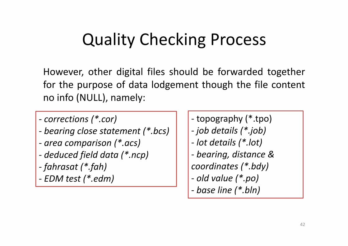
Quality Checking Process
However, other digital files should be forwarded togetherfor the purpose of data lodgement though the file contentno info (NULL), namely:
42
‐ corrections (*.cor)‐ bearing close statement (*.bcs)‐ area comparison (*.acs)‐ deduced field data (*.ncp)‐ fahrasat (*.fah)‐ EDM test (*.edm)
‐ topography (*.tpo)‐ job details (*.job)‐ lot details (*.lot)‐ bearing, distance & coordinates (*.bdy)‐ old value (*.po)‐ base line (*.bln)

Quality Checking Process
Adjustment on observation data by Full GNSS Methods
Mandatory digital files needed by the system for adjustingthe observed data as follows:
‐ Cadastral Reference Mark (*.crm)‐ CRM Point (*.pot)‐ Checkroll (*.crd)‐ Dairy (*.dry)‐ Fahrasat (*.Fah)‐ Traverses (*.tps)
43

Quality Checking Process
However, other digital files should be forwarded togetherfor the purpose of data lodgement though the file contentno info (NULL), namely:
44
‐ field book (*.fbk)‐ coordinates information (*.coo)‐ solar observation (*.sob) (Jika ada)‐ corrections (*.cor)‐ bearing close statement (*.bcs)‐ area comparison (*.acs)‐ deduced field data (*.ncp)
‐ EDM test (*.edm)‐ topography (*.tpo)‐ job details (*.job)‐ lot details (*.lot)‐ bearing, distance & coordinates (*.bdy)‐ old value (*.po)‐ base line (*.bln)

Quality Checking ProcessAdjustment on observation data by Combined Data GNSS andTraverses Method
Mandatory digital files needed by the system for adjusting theobserved data as follows:‐ Cadastral Reference Mark (* .crm)‐ CRM Point (* .pot)‐ Checkroll (* .crd)‐ Dairy (* .dry)‐ Fahrasat (* P.Fah)‐ Field book (* .fbk)‐ Geographical information (* .coo)‐ Traverses (* .tps)‐ Solar observation (* .sob) (Optional) 45

Quality Checking Process
However, other digital files should be forwarded togetherfor the purpose of data lodgement though the file contentno info (NULL), namely:
46
‐ corrections (*.cor)‐ bearing close statement (*.bcs)‐ area comparison (*.acs)‐ deduced field data (*.ncp)‐ fahrasat (*.fah)‐ EDM test (*.edm)
‐ topography (*.tpo)‐ job details (*.job)‐ lot details (*.lot)‐ bearing, distance & coordinates (*.bdy)‐ old value (*.po)‐ base line (*.bln)

Certified Plan (CP)
Certified Plan is the end product of cadastral survey reflectthe actual boundary on the ground (in relative terms)according to the format, media and scale set by DSMM forthe purpose of preparing final title and others. CertifiedPlan will be generated by DSMM or Licensed LandSurveyors.
47

Preparation Of Certified Plan
i. Certified Plan shall be prepared for land title survey, strata stratumtitle survey. However, the Certified Plan need not be provided forre‐survey unless:
a) Survey involves refixation or replacement of boundary marks;b) Survey involves upgrades. In this case, the re‐survey in accordance
with the provisions of circular to the existing lot that formerlywere surveyed using second class and below is considered asupgrades;
c) space on the existing Certified Plan insufficient to includeinformation according to Paragraph 44, circular Director general6/2009; and
d) involves a existing lot why share natural boundaries in accordancewith Paragraph 28(4), circular Director general 6/2009.
48
Preparation Of Certified Plan
ii. Certified Plan shall be prepared based on the coordinatevalues generated from NDCDB.
iii. Certified Plans must be drawn from existing survey recordsin cases where certified plans can not be detected orbecause their physical condition can not be used asParagraph 42(5), circular Director general 6/2009.
iv. For any survey carried out in stages, Certified Plan shall beprepared in accordance with Paragraph 42(6), circularDirector general 6/2009 and other procedures prescribed bythe Department.
49

Preparation Of Certified Plan
v. Numbering of Certified Plan shall be managed in accordanceas in Paragraph 60, circular Director general 6/2009.
vi. For Certified Plan that composition of NDCDB, theDepartment will use the digital pre‐computation plan ordigitized requisition survey received to generate theCertified Plan.
vii. Certified Plan used either A2 or A3 size.
viii. All offsets information should be shown in the Certified Planand generated from GLMS layer.
50

Data Shown In Certified Plan
i. All necessary information shown in Certified Plan shall begenerated from NDCDB as follows:
a. boundary marks; and boundary marks with number shouldbe shown in circle, while terms and symbols shall be inaccordance with the procedures prescribed by theDepartment.
b. lot number;c. lot area as prescribed by Paragraph 38(3), circular Director
general 6/2009;d. abuttal and lot numbers and numbers of Certified Plan
adjacent lots;
51

Data Shown In Certified Plan
e) administrative boundaries, if any;f) offsets related to roads, buildings and hydro if applicable
from GLMS layer;g) coordinate values for two extreme corner lot to the nearest
0,001 meters;h) bearing and distance to be generated in the form of
tabulation and shown to 10“ for bearing and the nearest0.001 meter for distance; and
i) for information that can not be shown due to insufficientspace, use diagram or diagrams without scale is allowed.
52

Data Shown In Certified Planii. Column text for each certified plan shall indicate:
a) Indicators north;b) Title information, as follows:
• name of State;• name of district;• name of county or town or country;• section number (where applicable);• lot number;• scale;• numbers certified plan earlier for subdivision;• original lot number and Certified Plan number in
subdivision or partition or other;• history of lot and related notes, if any. 53

Data Shown In Certified Plan
c. Survey file number;
d. District Land Office file number;
e. Standard Sheet Number;
f. Text of " Diluluskan " and the name of the State Director ofSurvey and Mapping;
g. Number Certified Plan; and
h. 2D Barcode.
54

Certificate on Certified Plan
For Certified Plan that generated for licensed land surveyor job,certificate must be presented in certified plan as follows:
“Saya ………………………………………………. seorangJuruukur Tanah yang dilesenkan di bawah Akta JuruukurTanah Berlesen 1958 (Akta 458), memperakui bahawapengukuran telah dijalankan dan ditanda di atas tanah oleh sayaatau di bawah arahan saya sendiri secara langsung di lapanganpada ..…… haribulan ………………….., 20 …………. semata‐mata mengikut Peraturan–peraturan Juruukur Tanah Berlesen.Bahawa saya bertanggungjawab sepenuhnya ke atas salahbetulnya ukuran ini.…………………………….....................................................Juruukur Tanah Yang Dilesenkan di bawah Akta 458”
55

56
Amendment On Survey Plan
i. Accordance with the provisions of section 396a of theNational Land Code 1965, the Director of Survey andMapping Affairs is responsible for amending andcorrecting mistakes or add data left on the CertifiedPlan which was approved in the followingcircumstances:
a) errors or omissions in the Certified Plan; orb) the change of administrative boundaries; orc) alienated land stop to be part of the town or country or
district.
57

Amendment On Survey Plan
ii. Correction procedure:
a) State Director of Survey and Mapping shall investigateand ensure that the mistakes or missed data isauthentic;
b) If authentic, updates NDCDB shall be made prior to theattributes that need to be amended or madecorrections and should be verified digital signature bythe State Director of Survey and Mapping.
58

Amendment On Survey Plan
c) Any amendments or corrections to be recorded indigital and amendment or correction on certified plangenerated are shown in red as follows:
• erroneously data shall be deleted and corrected;• data left to be added; and• correction or addition shall be digital signed by the State
Director of Survey and Mapping.
59

Amendment On Survey Plan
d) If many correction or amendment needs to be done,Certified Plan shall be regenerated by supplying newCertified Plan number, while the existing Certified Planis cancelled.
e) State Director of Survey and Mapping shall notify theRegistrar or the Land Administrator on any necessaryamendments to the plan title as a result of changes oradditional information to the certified plan.
60
Certified Plan For Re‐Survey
If the certified plan need not be provided for the re‐survey,the annotation shall be provided in the existing CertifiedPlan and signed by the State Director of Survey andMapping as below:
“Sempadan lot ……......... telah disahkan pada…………………..dalam fail…………………….
Pengarah Ukur dan Pemetaan”
61

Compilation Of Certified Plan
If the Certified Plan was drawn with all the lotboundaries values prepared according to existingcertified plans, the statement “Pelan disusun daripadaP.A. ...........” Shall be provided on a Certified Plan.
If the certified plan has been drawn in partial of theboundaries values prepared according to existingcertified plans, the statement “Diukur oleh….........dandisusun sebahagiannya daripada P.A. ….............” Shall beprovided on a Certified Plan.
62

Gazetted Plan
Requirements in gazetted plan under Section 62, 63 and 64of the National Land Code 1965. Section 433 National LandCode 1965 is the requirement of legal and specific notices.The plan has four categories: declarations on amendment,additions, production, and repeal. Application for gazettedplan requires an application letter, Form 126 Amendment1/86 (Requisition Survey) with Requisition Plan,Government Meeting Minutes (MMK) and the relatedapproval letter from MMK in respect of Survey Fee chargeunder Section 4 (2) of the National Land Code (Fee Survey),1965 (LN 486) for free.
63

Gazetted Plan
The gazetted plan contains gazette title, north point, scale,standard sheet number, departmental file number,administrative boundaries, abuttal, nearby lot numbers andCertified Plan number, area, number PT/HS(M)/lot, name ofchecker, name of the State Director of Survey and Mappingand gazetted plan number.
64

Gazetted Plan
The preparation of gazetted plan as follows:
a) Processing of the draft gazette plan and distribute forapproval
b) Processing gazette plan after receiving the approveddraft gazette plan for verification of State Director ofSurvey and Mapping.
c) distribute gazetted plans to gazette after the StateDirector of Survey and Mapping. (6 copies or 2 copies ofthe Gazette Plan and 2 copies of Certified Plan.
65

Preparation Of Gazetted Plan
Besides providing PA and PA(B), DSMM also provides GazettedPlan according to the existing laws, which include:
i. For public under Section 62 of the National Land Code 1965;ii. Forest reserve under Section 7 of the National Forestry Act
1984 (Act 313);iii. Malay Reserve under Malay Reservation Enactment;iv. Areas and Protected Places under Region and Protected
Places Act, 1959 (Act 298);v. Group settlement areas under Sections 4 and 5 of the Land
(Group Settlement Areas) Act 1960 (Act 530);vi. Election area under Section 7 of the Electoral Act 1958.
66
Preparation Of Gazetted Plan
Draft Gazette (DW) generated by the system based onthe requisition for gazette plan be certified in advance bythe applicant or land related agency before gazetted planprepared.
Each draft Gazette and the Gazetted Plan given a uniqueserial number, which is generated by the system.
67
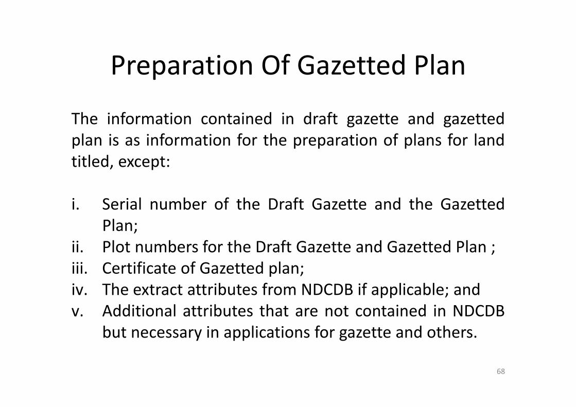
Preparation Of Gazetted Plan
The information contained in draft gazette and gazettedplan is as information for the preparation of plans for landtitled, except:
i. Serial number of the Draft Gazette and the GazettedPlan;
ii. Plot numbers for the Draft Gazette and Gazetted Plan ;iii. Certificate of Gazetted plan;iv. The extract attributes from NDCDB if applicable; andv. Additional attributes that are not contained in NDCDB
but necessary in applications for gazette and others.
68

ROLE OF JUPEM IN GAZETTED
OUTLINE
BackgroundObjective of Gazette Gazette Procedure Gazette Method Conclusion
69

Under the administration of the Selangor State Government,SUK has issued Circular No. 3 Year 2008 Under the StateProcedure for the Open Space Gazette. Where it is synthesizedin the following situations:
The open space that has certified plan,
The open space is located in the area that has been developed but not yet surveyed.
BACKGROUND
ROLE OF JUPEM IN GAZETTE
70
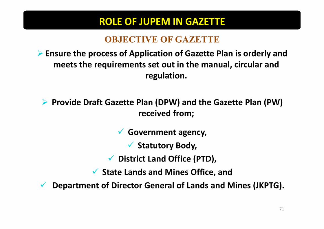
OBJECTIVE OF GAZETTEEnsure the process of Application of Gazette Plan is orderly and
meets the requirements set out in the manual, circular and regulation.
Provide Draft Gazette Plan (DPW) and the Gazette Plan (PW) received from;
Government agency, Statutory Body,
District Land Office (PTD), State Lands and Mines Office, and
Department of Director General of Lands and Mines (JKPTG).
ROLE OF JUPEM IN GAZETTE
71

PROCEDURE OF GAZETTE
GAZETTEUnder Section 62 NLC Other than Section 62
NLC
PURPOSE:Notice regarding lot for public
purpose
PURPOSE:Notice regarding no authorities having
right on related area
ROLE OF JUPEM IN GAZETTE
Gazette involve survey of lot in the field
Example : School, Mosque/surau, Cemetery, Open space, Sewerage area, Playground and other.
Gazette not involve survey of lot in the field
Example : Malay Reserve, Forest Reserve, Cancellation of Forest Reserve, Open Space, Catchment area, Election area and other.
72
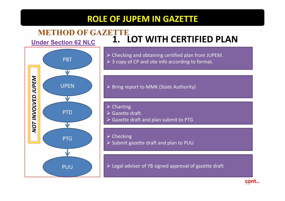
METHOD OF GAZETTE1. LOT WITH CERTIFIED PLAN
PBT
UPEN
PTD
PTG
PUU
Checking and obtaining certified plan from JUPEM. 3 copy of CP and site info according to format.
Bring report to MMK (State Authority)
Charting. Gazette draft. Gazette draft and plan submit to PTG
Checking Submit gazette draft and plan to PUU
Legal advisor of YB signed approval of gazette draft
cont..
Under Section 62 NLC
ROLE OF JUPEM IN GAZETTENOT INVO
LVED
JUPE
M
73

PUU
PTG
PTD
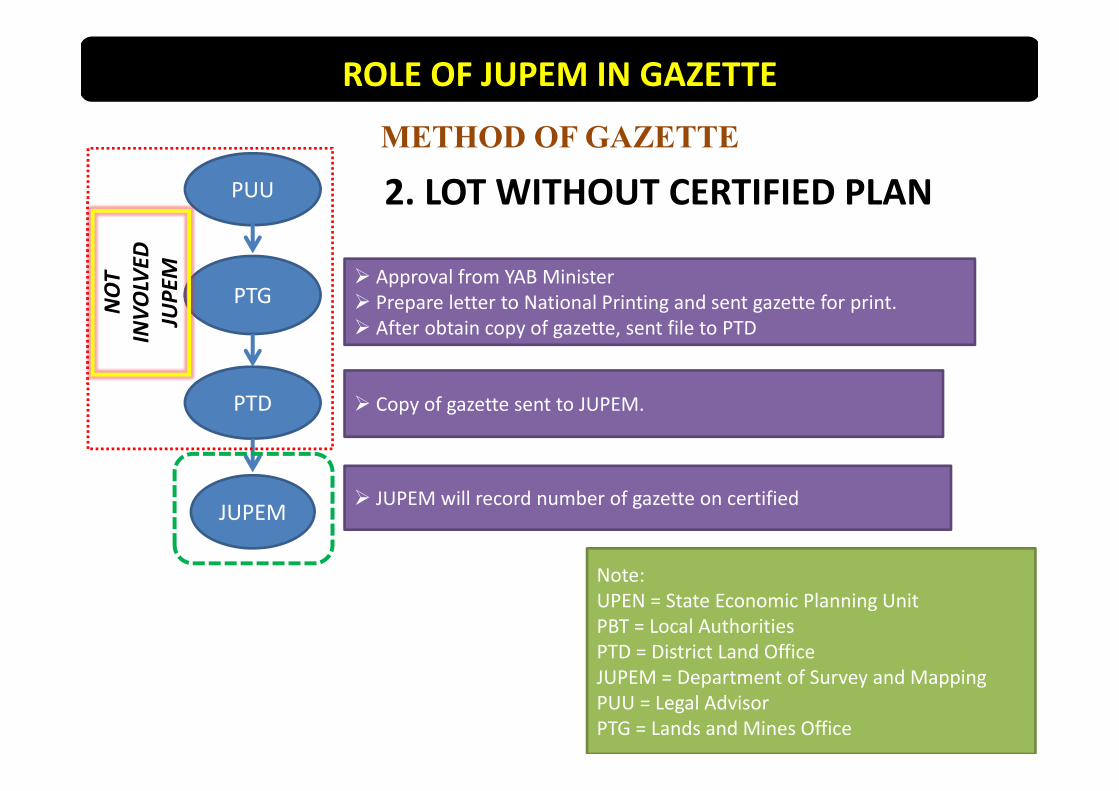
Approval from YAB Minister Prepare letter to National Printing and sent gazette for print. After obtain copy of gazette, sent file to PTD
Copy of gazette sent to JUPEM.
Note:UPEN = State Economic Planning UnitPBT = Local AuthoritiesPTD = District Land OfficeJUPEM = Department of Survey and MappingPUU = Legal AdvisorPTG = Lands and Mines Office
METHOD OF GAZETTE
1. LOT WITH CERTIFIED PLAN
JUPEM JUPEM will record number of gazette on certified plan.
ROLE OF JUPEM IN GAZETTENOT INVO
LVED
JUPE
M
74
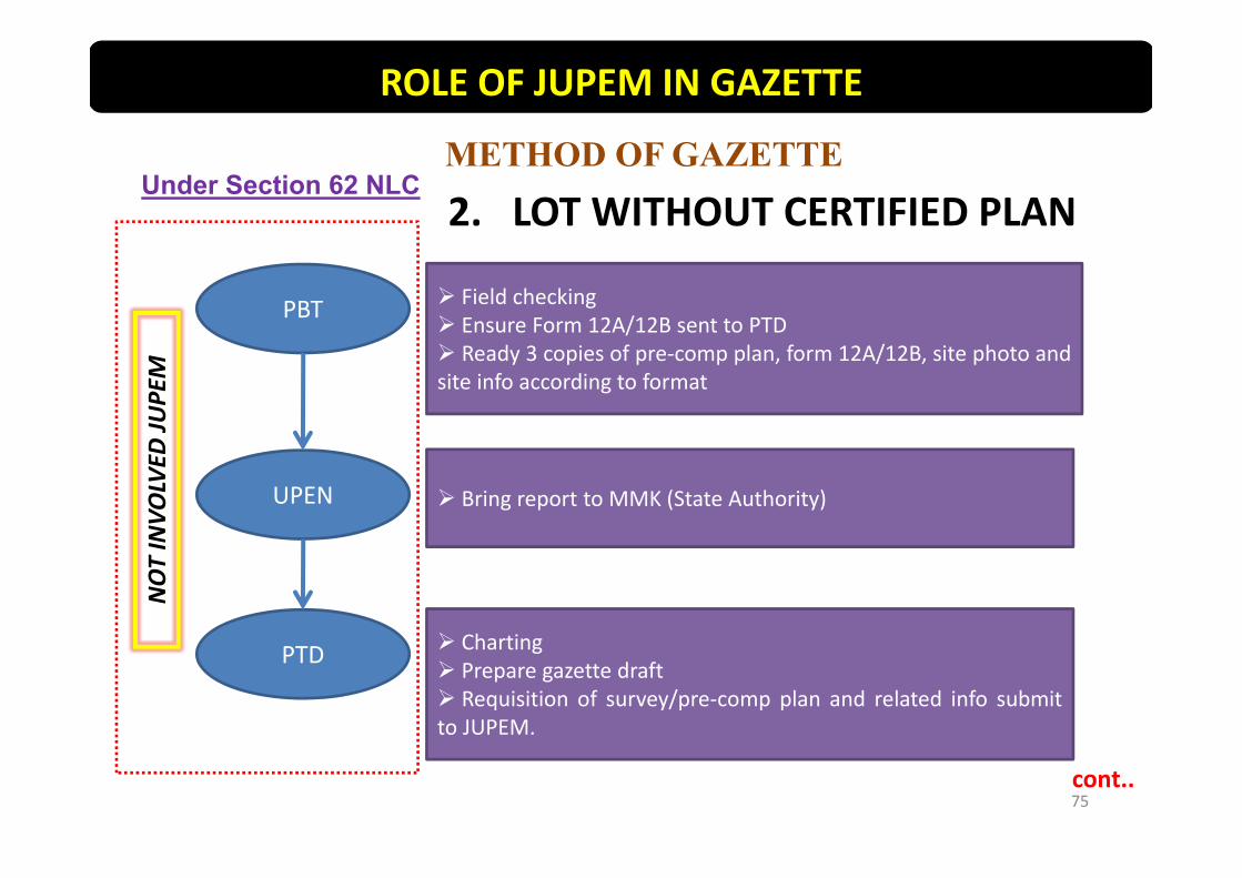
PBT
UPEN
PTD
Field checking Ensure Form 12A/12B sent to PTD Ready 3 copies of pre‐comp plan, form 12A/12B, site photo andsite info according to format
Charting Prepare gazette draft Requisition of survey/pre‐comp plan and related info submitto JUPEM.
Bring report to MMK (State Authority)
cont..
METHOD OF GAZETTE
2. LOT WITHOUT CERTIFIED PLAN
ROLE OF JUPEM IN GAZETTE
Under Section 62 NLCNOT INVO
LVED
JUPE
M
75

PTD
FIELD SURVEY (Prepare CP) JUPEM
PTD
PTG
PUU
Gazette draft and plan submit to PTG
If with CP – JUPEM sent copy of certified plan to PTD
Without CP
Checking Submit gazette draft and plan to PUU
Legal advisor of YB signed approval of gazette draft
cont..
METHOD OF GAZETTE2. LOT WITHOUT CERTIFIED PLAN
ROLE OF JUPEM IN GAZETTE
WORK PROCESS
NOT
INVO
LVED
JUPE
M
76
PUU
PTG
PTD
Approval from YAB Minister Prepare letter to National Printing and sent gazette for print. After obtain copy of gazette, sent file to PTD
Copy of gazette sent to JUPEM.
METHOD OF GAZETTE
2. LOT WITHOUT CERTIFIED PLAN
JUPEM JUPEM will record number of gazette on certified
ROLE OF JUPEM IN GAZETTENOT
INVO
LVED
JUPE
M
77
Note:UPEN = State Economic Planning UnitPBT = Local AuthoritiesPTD = District Land OfficeJUPEM = Department of Survey and MappingPUU = Legal AdvisorPTG = Lands and Mines Office
GAZETTE PROCEDURE
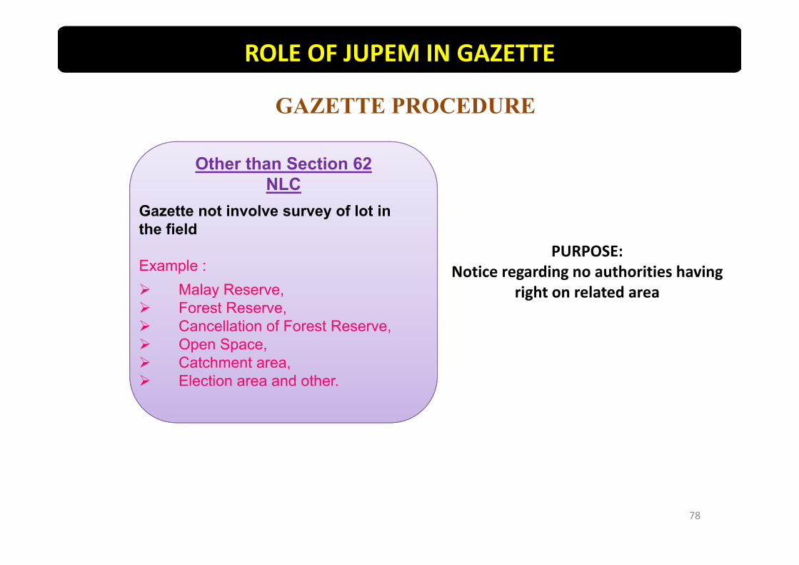
Other than Section 62 NLC
Gazette not involve survey of lot in the field
Example : Malay Reserve, Forest Reserve, Cancellation of Forest Reserve, Open Space, Catchment area, Election area and other.
PURPOSE:Notice regarding no authorities having
right on related area
ROLE OF JUPEM IN GAZETTE
78

cont..
Gazette other than Section 62 NLC
Land Title Section
Register gazette file
If PTG/PTD/agency needs gazette plan. The information submitted
is complete
Gazette Unit (PUSELW)
JUPEM send draft gazette plan (DPW) for approval of related PTG/PTD/agency. A copy of the DPW is kept
in the file.
Preparation of Draft Gazette
Plan
PTG/PTD other agency
Deputy Director of Survey & Mapping (I)
(approve DPW)
METHOD OF GAZETTE
ROLE OF JUPEM IN GAZETTE
Process of Preparation of the Gazette Plan Refer APPENDIX G
79

SUMMARY OF WORK PROCEDURE
cont..
PTG/PTD other agency
If DPW approved
Deputy Director of Survey & Mapping (II)
Deputy Director of Survey & Mapping (I)(Checking & verify)
Land Title Section
Gazette UnitPreparation of Gazette Plan
ROLE OF JUPEM IN GAZETTE
Process of Preparation of the Gazette Plan Refer APPENDIX G
80

SUMMARY OF WORK PROCEDURE
Deputy Director of Survey & Mapping (I)(Checking & verify)
Director of Survey (Approve Gazette
Plan)
PTG/PTD other agency
JUPEM sent Gazette Plan and Gazette Schedule to related PTG/PTD/agency
PTG/PTD must send a Gazette Notification number to JUPEM for annotation on the Gazette Plan after Minister approved
ROLE OF JUPEM IN GAZETTE
81

CONCLUSION
Understanding and cooperation between JUPEM/PTG/PTD/Other agencies can facilitate the process of gazetting and guaranteeing rights to
interested parties,
The gazette process can be implemented quickly and transparently,
The latest information on the land will be maintained and secured
ROLE OF JUPEM IN GAZETTE

83

84

85

86

87
88
89

90

Preparation Of Certified Plan For Mining Lease
Before Certified Plan for Mining Leases can be prepared,Mining Certificate shall be prepared based NDCDB forapproval of the State Authority.
For work done by Licensed Land Surveyor, the pre‐computation plan submitted to DSMM shall be based onNDCDB and generated for the purpose of Lot Plan for theMining Certificate.
91

Preparation Of Certified Plan For Mining Lease
Methods and survey process for preparing of MiningCertificate is same as the survey for the purpose of landtitle
Certified Plan for Mining Lease can only be provided afterMining Certificate approved by the State Authority.
Certified Plan for Mining Lease Format and preparationprocedure is as Certified Plan for land titles.
92

Others Plan
Others plan are drawn from title plan which includinggazette plan. Examples of such survey at the crime scene,racing sports, contour, offshore. All sample survey requiresothers plans when requested by departments orgovernment agencies.
93

Others Plan
Title on the others plan should be clearly stated thepurpose of the plan is drawn. Other information that needsto be shown is scale, county, district and reference files.Due to others plan are not deposited plans as providedunder Section 410 of the National Land Code 1965, thenthis plan does not need to be certified or approved by theState Director of Survey and Mapping.
94

95

Preparation Of Multi Purpose Plan
Multi Purpose Plan is provided to illustrate the positionof a plot of various survey work made or received by theDepartment from time to time.
Multi Purpose plan shall be prepared accordingly exceptthat involve survey in the field.
96

Preparation Of Multi Purpose Plan
Any amendment to Multi Purpose Plan as amendmentprocedure in certified plan.
Information contained in the Multi Purpose Plan is as inCertified Plan with additional information as follows:
i. Purpose of surveyii. Multi Purpose Plan Serial Number
97
Land Ownership Plan
Land ownership plan is issued in compliance with theprovisions of section 86 (c) and 87 (c) of the National LandCode 1965, strata titles plan issued in accordance withsection 16(2) (b) of the Strata Titles Act 1985 and alsomining leases issued in accordance section 27 of the Mining(Mining Enactment) (Cap147).
98
Land Ownership Plan
Confirmation of land ownership plans, strata title andmining lease are made based on section 3 of the Plan andLand Document and Mining (Photographic Copies) Act 1950(Revised 1980). The plan is taken either partially or entiretyfrom the existing certified plan. Authentication of the planphotograph taken for part and whole of the existing planshould be created using a separate certification statementand ensure that is legally. Confirmation is made using acertificate that such statements are stated in paragraph 3 ofDirector General Circular 1/1985.
99

Amendment Of Land Ownership Plan
Director of Survey and Mapping shall notify the Registrar orthe Land Administrator on any amendments to the plantitle as a result of changes in or additional information tothe Certified plan .
100

Preparation Of Duplicate Title
Documents of title to the replacement shall be provided inaccordance with the provisions of section 166 of the NationalLand Code 1965.
Before the replacement of title documents provided, Directorof Survey and Mapping shall ensure that the Registrar or theLand Administrator has provided sufficient evidence that theoriginal title documents:
i. cancelled;ii. disappear;iii. destroyed in whole or in part; oriv. Fully use
101

Verification Copies Of Partial Photographic Plan
If it involves a small lot, partial copy of the photograph topartly certified plan shall be made. Appropriate methodsfor providing certificate shall be determined for example byproviding frames that contain separate certificatestatements to use when taking a copy of the plan. This willavoid short cuts and signature made on each copy of theplan. A certificate shall be made and contain the followingstatement:
102

Verification Copies Of Partial Photographic Plan
"Adalah diakui mengikut seksyen 3 dalam Akta Pelan danDokumen Tanah dan Lombong (Salinan Fotograf) 1950(Semakan 1980), bahawa ini ialah salinan pelan yang betullagi benar yang telah dibuat pada ......... bagi lot ..… didalam .......... (contoh: Mukim/Bandar/Pekan dsbnya)………… (contoh: Daerah/Jajahan) seperti ditunjuk di ataspelan……………"
Signature of the State Director of Survey and Mapping orrepresentative
103
Verification Copies Of Whole Photographic Plan
If it involves a large lot that can not fit into the frame, acopy of the photograph of the overall certified plan and thecertified strata plan should be made. Information such aslot number, district, town and etc does not need to bespecified in the certificate because the information isshown on the copy of the plan when a copy of the entireplan is taken. A certificate shall be made and contain thefollowing statement:
104
Verification Copies Of Whole Photographic Plan
"Adalah diakui mengikut seksyen 3 dalam Akta Pelan danDokumen Tanah dan Lombong (Salinan Fotograf) 1950(Semakan 1980), bahawa ini ialah salinan pelan .................yang betul lagi benar yang telah dibuat pada........................ "
Signature of the State Director of Survey and Mapping orrepresentative
105

Preparation Of Digital Land Title Plan (B1 TIFF)
Digital land title plan by DSMM is based on the provisionsof paragraph 5(1), Table 14 (Section 5A), the National LandCode 1965. According to the existing practice, DSMMprovide two copies of final title plan based on Certified Planfor the related lot. Copy of the land title pan will becertified by the State Director of Survey and Mapping or hisrepresentative to meet the requirements of Section 3 of theAct, Planning, Lands and Mines Documents (PhotographicCopies‐Revised 1980) and the Director General Circular1/1998.
106

Preparation Of Digital Land Title Plan (B1 TIFF)
This module allows the land title Plan prepared in Tiffformat and is designed according to the requirements inForm B1 as in the Computerised Land Registration System(CLRS). Land title plan is then sent to the State landoffice/land and mines office online. Module B1 Tiff usingdata from image system and digital cadastre database forpreparation of digitized land title.
107
Preparation Of Digital Land Title Plan (B1 TIFF)
In line with the ICT, DSMM developed an applications inpreparing digital land titles (B1 Tiff). This module allows theland title Plan in Tiff format and is designed according toForm B1 in the Computerised Land Registration System(CLRS). Land title plan then sent to the District Land Officeor State Land And Mines Office in softcopy format online.
108
Preparation Of Digital Land Title Plan (B1 TIFF)
Module B1 Tiff using data from Document ImageManagement System (SPID) and the National DigitalCadastral Database (NDCDB). To facilitate the provision ofdigital land title plan (B1 Tiff) is implemented, a guidelinehas been prepared to explain the procedures.
109

Preparation Of Digital Land Title Plan (B1 TIFF)
Module B1 Tiff should be implemented by all State DSMMfor the preparation of all types of titles either normal orredraft. To ensure this module runs smoothly, certified planof related lots together with NDCDB and SPID should beupdated first..
110

Preparation Of Digital Land Title Plan (B1 TIFF)
If the frame for B1 Tiff format can not cope with graphicdisplay for the entire lot or lots which have many certifiedplans, follow the requirement from Director GeneralCircular No. 1/1985 and 1/1998.
111
Preparation Work Flow Of B1 TIFF
Preparation work flow of B1 Tiff as follows:
a) Action by Head of Registration and Records Uniti. Received instruction to prepare land title plan.ii. Enter the number of Certified Plan.iii. Provide basic information of NDCDB and SPID Generate
basic data using B1 Data Creator Module.iv. Identify Processor to process B1 tiff Plan.v. Minutes to the processor for generating B1 Tiff Plan.
112

Preparation Work Flow Of B1 TIFF
b) Action by processor
i. Received instruction from unit head and ensure basic dataexists in the folder certified plan (NetB1 PreparationModule).
ii. Create register process and transparent Certified Plans in tiffusing NDCDB.
iii. Use NetB1 Preparation Module to generate B1 tiff Plan foreach lot.
iv. Prepare *.tiff format plan for related lots according to scale.v. Minutes and distribute files through eSRS to Registration
and Records Unit.
113

Preparation Work Flow Of B1 TIFF
c) Action by Head of Registration and Records Unit
i. Collect Certified Plans folder in B1 tiff.ii. Prepare PA_ List.iii. Use district sorter to receive survey file and make sure all
the information was generated.iv. Isolate B1 tiff according to district.v. Prepare Land Registry file.vi. Sent online to District Land Office or State Land and Mines
Office.vii. Check the storage media to ensure that the information in
the back‐up is complete.
114

Preparation Work Flow Of B1 TIFF
viii. Prepare the following items to be forwarded to State Landand Mines Office/District Land Office:
•B1 tiff online•Statement of Wages of Survey fee (if)•Covering letter to the State Land and Mines Office/District LandOffice.•Acknowledgement.ix. Minutes and distribute files to unit head for further action.
d) Deputy Director of Survey minutes and distribute files toRegistration and Records Survey unit to measure thetransmission of documents to District Land and Mines/ StateLand and Mines Office.
115

Digital Signatures
In eKadaster, all data and plans are generated in digitalform. Sending, receiving, processing and generation ofsurvey results is online.
To ensure credibility and accountability as well as thesurvey data and plans that are generated, the data and planmust be digital signed using Public Key Infrastructure (PKI).
116
Digital Signatures
Only Trusted Certification Authority authorized underMalaysian Communications and Multimedia Commission Act562, Digital Signature Act 1997 can be used for digital signatures.
It is the responsibility of all and be sure that all the documentsand plans are in place before making the digital signature.
All information such as user ID or password associated withPKI shall be maintained and kept by the parties involved with thesecret and be careful that PKI is not misused by unscrupulouspeople.
117

Digital Signatures
Two (2) methods for digital signature as follows:i. Onlineii. Offline
For digital signature online, the Director of Survey andMapping and Licensed Land Surveyor will implement it using aportal which has been developed by the Department. Whereasfor offline digital signature will be done locally on each computerthrough software developed by the Department.
118

THANK YOU
119