land at anchor road/deanery road bristol...
TRANSCRIPT
© Cotswold Archaeology
LAND AT ANCHOR ROAD/DEANERY ROAD BRISTOL
STRATIGRAPHY AND PALAEOENVIRONMENT
CA PROJECT: 1314 CA REPORT: 02104
Author: Keith Wilkinson
Approved:
Signed:
Mark Collard
…………………………………………………………….
Issue: 01 Date: 30 September 2002
This report is confidential to the client. Cotswold Archaeology accepts no responsibility or liability to any third party to whom this report, or any part of it, is made known. Any such party relies upon this report entirely at their own risk. No part of this report may be reproduced by any means without permission.
© Cotswold Archaeology
Headquarters Building, Kemble Business Park, Cirencester, Gloucestershire, GL7 6BQ Tel. 01285 771022 Fax. 01285 771033 E-mail: [email protected]
Land at Anchor Road/Deanery Road, Bristol
2
© Cotswold Archaeology
CONTENTS
SUMMARY ..................................................................................................................... 4
1. INTRODUCTION ........................................................................................................ 5
2. GEOLOGICAL BACKGROUND .................................................................................. 7
3. METHODOLOGY ........................................................................................................ 7
4. LITHOSTRATIGRAPHY .............................................................................................. 9
5. FORAMINIFERA ......................................................................................................... 13
Introduction ........................................................................................................ 13 Methods ............................................................................................................. 13 Results ............................................................................................................... 14 Discussion .......................................................................................................... 15
6. DIATOM ANALYSIS .................................................................................................... 16
Methods ............................................................................................................. 16 Results ............................................................................................................... 17 Discussion .......................................................................................................... 18 Summary ............................................................................................................ 19
7. POLLEN ANALYSIS ................................................................................................... 19
Methods ............................................................................................................. 19 Results ............................................................................................................... 21 Interpretation ...................................................................................................... 23 Discussion .......................................................................................................... 26
8. PLANT MACROFOSSIL ANALYSIS ........................................................................... 28
Methods ............................................................................................................. 28 Results ............................................................................................................... 29 Discussion .......................................................................................................... 30
Land at Anchor Road/Deanery Road, Bristol
3
© Cotswold Archaeology
9. DISCUSSION .............................................................................................................. 32
Palaeoenvironments ........................................................................................... 32 Addressing the research questions .................................................................... 35
10. CONCLUSIONS ........................................................................................................ 36
11. ACKNOWLEDGEMENTS ......................................................................................... 38
12. BIBLIOGRAPHY ....................................................................................................... 38
APPENDIX A: NOTES ON POLLEN TYPES .................................................................. 44
LIST OF ILLUSTRATIONS
Fig. 1. Location plan
Fig. 2. Location of geotechnical (GBH) and archaeological boreholes (BH) within the site
Fig. 3. Composite stratigraphy of the site obtained from geotechnical and archaeological
boreholes. For borehole locations see Fig. 2
Fig.4 Sedimentology of Units 2-5 in BH2
Fig. 5a Tree, shrub, climber and herb percentage pollen histogram from BH2
Fig. 5b. Marsh, aquatic, fern and algae percentage pollen diagram from BH2

Land at Anchor Road/Deanery Road, Bristol
4
© Cotswold Archaeology
SUMMARY
A borehole survey carried out as part of a programme of archaeological investigations at
Anchor Road/Deanery Road, Bristol (centred on ST 58129 72626) has revealed important
new data regarding Neolithic and later prehistoric palaeoenvironments of what is now central
Bristol. Six lithostratigraphic units were recognised in two archaeological (BH2 and BH3) and
three geotechnical bores holes. The base of the sequence rests on Triassic sandstones,
formed between 250 and 200 million years ago. The top of this sandstone has weathered
and undergone soil formation, perhaps as recently as the late Quaternary. Overlying this
geological substrate is a thin mineral silt/clay that appears to have formed on the floodplain
of the river Avon between 9300 and 4000 cal. BC. As a result of movement of that river away
from the sampled site, or because deposition on the floodplain outstripped base level rise,
the area became marginalized from the river. This in turn led to the formation of organic mud
strata from 4220-3790 cal. BC onwards in which relatively well-preserved pollen grains were
found. The palynological data suggest that at this time the site consisted of freshwater pools
at the floodplain edge around which lay alder forest. Further away still, on the surrounding
high ground lime-dominated forests had developed. There is evidence in this part of the
sequence for burning and the influx of ash, perhaps as a result of localised forest clearance
by people. During the middle Neolithic sea-levels rose, and following a marine incursion of
the site around 3500 cal. BC the alder woodland declined. Following this episode a true peat
developed in freshwater conditions. Meanwhile human clearance of the lime forest
commenced. At around 3550-3050 cal. BC sea levels rose once more and the site became
part of the intertidal zone. Further mineral silts and clays were deposited in a saltmarsh
environment. However, some time later, perhaps in the Bronze Age the site was briefly
exposed once more to terrestrial processes, and there is short-lived evidence for human
exploitation of the marsh. Two subsequent episodes of similar saltmarsh exploitation are
recognised in the sedimentological data, but remain undated. In either the later medieval or
post-medieval periods the site was ‘reclaimed’ by the simple expedient of deliberately
depositing substantial quantities of sediment upon it and hence raising it above tidal level.

Land at Anchor Road/Deanery Road, Bristol
5
© Cotswold Archaeology
1. INTRODUCTION
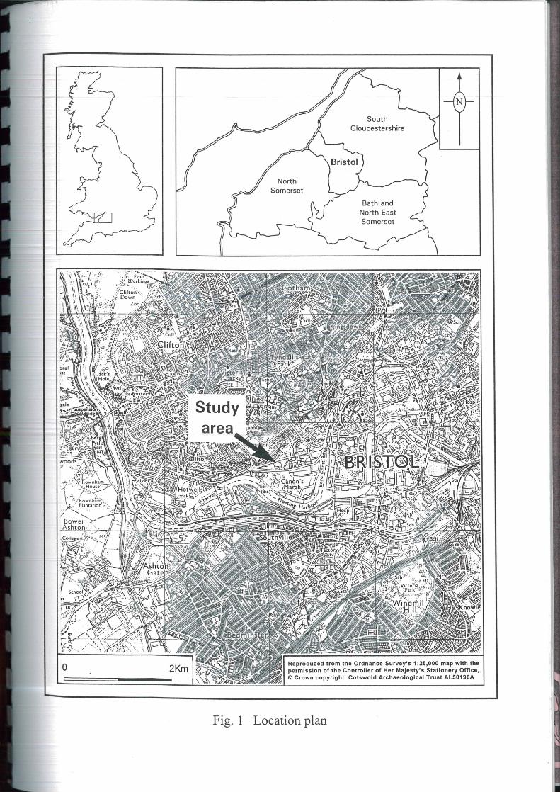
1.1 The site at Anchor Road/Deanery Road, Bristol (Fig.1; centred on ST 58129 72626)
was the subject of an archaeological evaluation and subsequent excavation by
Cotswold Archaeological Trust on behalf of Beaufort Western Limited (now Crosby
Homes (Special Projects) Limited) in 2000-2001 (CAT 2000; 2001). Both these
investigations concentrated on near-surface remains revealed in standard
archaeological trenches and dating to the medieval and post-medieval periods. To
investigate deeper parts of the site stratigraphy buried beneath recent ‘fill’ and
historic period estuarine/alluvial silts and clays, a borehole survey was also carried
out (Fig. 2), with a particular focus on peat strata that had been discovered as a
subcrop between +1m OD and +4m OD in a previous geotechnical survey, carried
out in March and April 2000 (Geotechnical Engineering Limited 2000) Peat forms is
a variety of depositional environments, but in lowland situations is typically
associated with floodplain edges or intertidal margins. These zones have been
frequently used by past human populations, while because of the waterlogged
conditions in which peat is commonly preserved, the potential for preservation of
archaeologically important material is high. Given that peat strata from central Bristol
have not previously been investigated, or indeed found during the course of
archaeological fieldwork (c.f. Bell 2001), the stratigraphy of the site is hence of both
local and regional significance.
1.2 Following completion of the archaeological fieldwork an assessment was carried out
of the borehole stratigraphy (Wilkinson 2001). This took the form of a detailed
description of the extracted cores and the plotting of the reconstructed stratigraphy,
against that revealed in the geotechnical boreholes (Fig. 3). As a result of this study
recommendations were made for further, more detailed analysis to address the
following questions:
• How old was the stratigraphy found below the ‘made ground’ in which the
medieval and post-medieval remains investigated by Cotswold
Archaeological Trust were found?

Land at Anchor Road/Deanery Road, Bristol
6
© Cotswold Archaeology
• How did the peat revealed in the borehole studies form – in a brackish or
freshwater environment?
• Were the apparently weathered layers noted during the assessment in, and
at the surface of clays and silts, which occur below the ‘made ground’, the
result of terrestrial processes or merely localised discolourations of the
intertidal/alluvial stratigraphy?
• Was there any direct or indirect evidence of human activity in the terrestrial
sediments (i.e. peats or ‘surfaces’ in the silts and clays)?
• Did the clays and silts represent accumulation in brackish or freshwater
environments?
1.3 This document reports on the results of the analytical studies recommended in the
assessment report to address these questions (Wilkinson 2001). In the next section
the geological background to the area is discussed. Following this the stratigraphy of
the site, as revealed in the boreholes is discussed in relation to laboratory-based
sedimentological analyses and 14C dating, carried out on cores of archaeological
borehole BH2. Following the establishment of this lithological background, two
classes of microfossils that are used as aids to sea-level reconstruction are then
discussed; firstly Foraminifera and then diatoms. The last category of data
presented in the report relate to botanical remains found from the peat itself.
Palynology (i.e. the analysis of sub-fossil pollen) is discussed first, followed by a
study of plant macro-remains. The penultimate section of the report draws the data
of the previous sections together to both present an account of past environments of
the area surrounding the site in prehistory, and addressing the questions set out
above. The concluding pages of the report assess the importance of the new data
for future archaeological and palaeoenvironmental studies in Bristol. The editing
author wrote all sections unless indicated otherwise.
1.4 Throughout this report, except where otherwise indicated all depth measurements
are in relation to the ground surface. 14C dates are discussed in relation to
calibrations carried out using the INTCAL 98 curve of Stuiver et al. (1998). All
calibrated date ranges used have been calculated at 2σ (95.4%) probability using
the OcCAL 3.5 program (Bronk Ramsey 2000).

Land at Anchor Road/Deanery Road, Bristol
7
© Cotswold Archaeology
2. GEOLOGICAL BACKGROUND
2.1 The site lies close to the modern channel of the River Avon on the edge of central
Bristol. The high ground of Brandon Hill rises behind the site and the Avon Gorge
lies just downstream The drift geology of the area is mapped by the British
Geological Survey (BGS) as ‘Quaternary Alluvium’, a catchall title used by the BGS
to describe all recent (usually Holocene) fine-grained deposits forming in riverine
and intertidal environments. In the case of this site ‘Quaternary alluvium’ includes all
Holocene intertidal and alluvial (senso stricto) silts/clay strata, as well as the
potentially archaeologically important peats. According to the BGS the solid geology
lying beneath the site comprises deposits of Triassic sandstones. These were found
as a subcrop by the geotechnical survey at depths of between 0m OD and –1m OD
(Fig. 3). The same survey demonstrated that 2-4m of fining upwards, red sands and
silts overlies the bedrock deposits, whilst on top of these ‘alluvium’ was found. The
red, fine-grained sediments are likely to be weathered and redeposited sediments
originally derived from the underlying Triassic sandstones.
3. METHODOLOGY
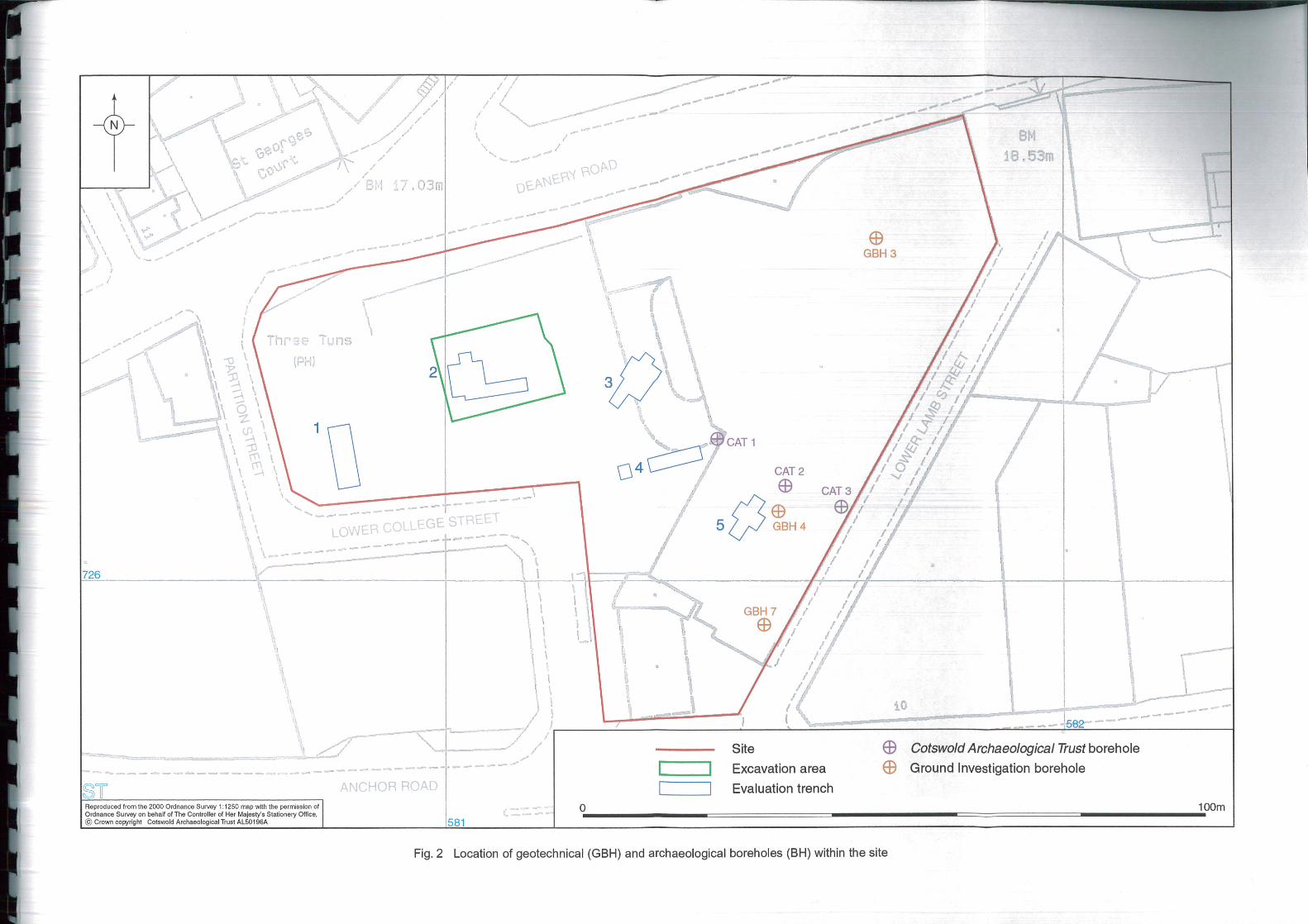
3.1 The original geotechnical investigation 10 boreholes and 15 test pits concentrated
on the northeast part of the site (Fig. 2). Given the equipment used (a cable
percussive drilling rig for boreholes and the rear actor of a mechanical excavator for
test pits) and the purpose of the investigation (aiding decisions regarding
foundation/pile configuration), stratigraphic resolution can be estimated at ±0.10-
0.20m at best. Such a low resolution is of only limited use in archaeological
investigations. Hence for the purposes of the archaeological investigation three
specifically archaeological boreholes were drilled in the south-eastern part of the site
(Fig. 2), where peat had been revealed by the geotechnical boreholes, and the
geotechnical boreholes were widely separated.
3.2 The boreholes were drilled by technicians from an external contractor, supervised by
Cotswold Archaeological Trust, over a period of three days in January 2001. The
author made a visit to the site for a single morning to monitor progress. The works

Land at Anchor Road/Deanery Road, Bristol
8
© Cotswold Archaeology
were also visited by Bob Jones, Bristol City Council Archaeologist, and Vanessa
Straker, English Heritage South-west Regional Archaeological Scientific Advisor.
Prior to drilling, the uppermost 0.5m of demolition debris forming the top of the
‘made ground’ was removed by a mechanical excavator. A Copco Cobra pneumatic
auger fitted with a 1m core sampling device was used to drill the boreholes. The
procedure for each hole was to drill through ‘made ground’ that still remained using
a gouge head and then sample the underlying stratigraphy in Perspex tubes using
the core-sampler. In order to aid penetration the holes were tapered downwards by
using increasingly narrow diameter core samplers. Individual tubes were marked
with the borehole number, depth and direction of their base and were transported to
the laboratory for further study. This procedure worked reasonably well in the case
of BH2 and BH3, but the deposits in the vicinity of BH 1 were so compact that the
core sampler could not be used. Therefore for this borehole the entire stratigraphy
was drilled using the gouge head and sediment retrieved in the sample chamber
was opportunistically sampled. Because of these problems BH 1 is not considered
any further in this report.
3.3 Upon arrival at the laboratory the sample tubes (and bag samples from BH 1) were
placed in cold storage at 2-3oC. The tubes were then cut lengthways using an angle
grinder to reveal the stratigraphy. This was described according to the Troels-Smith
system commonly used on intertidal deposits (Troels-Smith 1955). However, for the
purposes of this report Troels-Smith nomenclature has been translated into standard
geological terminology (c.f. Tucker 1982). Following completion of the assessment
report (Wilkinson 2001) cores from BH2 were subsequently sub-sampled for
sedimentological, micro- and macro-biological analysis, and 14C dating. The focus
for these sub-samples was peat, encountered between 7.30m and 8.20m below
ground surface and associated deposits. ‘Blocks’ of sediment, each 20mm thick
were removed from the cores between 5.20m and 9.00m for sedimentological
analysis. Similar sub-samples, but of 10mm thickness were removed at varied
intervals for Foraminiferal analysis between 6.55m and 8.43m (12 samples), for
diatom analysis between 6.55m and 7.36m (8 samples), and for palynological
analysis between 7.20m and 8.20m (10 samples). Two samples, each a 100mm
thick block of sediment were removed for plant macro remain analysis between
7.35m and 7.85m, while two 20mm thick samples for 14C dating were taken from
near the top and base of the peat (Table 1). Methodologies used in each of these
analyses, with the exception of the sedimentary tests, are discussed in the relevant
sections below.

Land at Anchor Road/Deanery Road, Bristol
9
© Cotswold Archaeology
3.4 The sedimentological tests performed on all 177 sub-samples obtained between
5.20m and 9.00m were designed to further characterise the deposit beyond that
obtained from the laboratory description, and to help reconstruct the environment in
which the sampled deposit formed. Four separate tests were carried out (Fig. 4).
Field moisture was determined by determining the percentage loss in mass of a
sample from its state when sampled and following air-drying at 40oC for 24 hours.
The moisture content of sediment relates to a combination of ground water table
height, grain size and organic content. Both low (χlf) and high (χhf) frequency
magnetic susceptibility were subsequently determined on the <2mm fraction of the
dried sub-samples according to the methodology of Gale and Hoare (1991, 221-
226). The results of each were then used to calculate percentage frequency
difference (χfd). Magnetic susceptibility variations are caused by a number of factors
including the type and quantity of iron minerals in the geological source material,
grain size, organic content, soil formation and burning. The last sedimentary test
determined the organic content. This was achieved by combusting sub-samples
previously used for magnetic susceptibility measurement at 550oC for four hours and
measuring the percentage loss in weight.
4. LITHOSTRATIGRAPHY
4.1 The stratigraphy revealed in BH 2 and BH 3, together with that detailed in the logs of
surrounding geotechnical boreholes (GBH) 3, 4 and 7, is broadly similar and can be
grouped into six strata (Units) (Fig. 3). Further details relating the accumulation of
four of these (Units 2-5) were further documented in the results of the sedimentary
tests detailed in the previous section (Fig. 4). The discussion below integrates
stratigraphic and sedimentary data, together with the results of 14C dating.
Unit 1 ‘Made ground’ - (c. +11 - +6.5m OD) 4.2 This stratum comprises a complex of diamicts, gravels and thin lenses of silt, all
(with the possible exception of the latter) deliberately deposited as demolition debris
and levelling material. Brick fragments of a relatively recent date occur throughout
the stratigraphy, suggesting that the whole layer cannot be older than the post-
medieval period. The silt lenses probably relate to localised flood events, from either
the adjacent river or a local stream. The lower boundary of the unit is sharp, while
differences in height between boreholes indicate that it was also undulating.

Land at Anchor Road/Deanery Road, Bristol
10
© Cotswold Archaeology
Together these data suggest an unconformity between this and the underlying Unit
2.
Unit 2 Upper clay-silts (c. +6.5 - +3m OD) 4.3 In BH2 this unit comprises greyish brown (Munsell 2.5 Y 5/2) bedded clay silts with
occasional lenses of shell fragments and organic detritus, the latter typically
comprising 5-10% by mass of the total (Fig. 4). These characteristics suggest the
deposit formed in low energy intertidal or alluvial conditions. Nevertheless the upper
surface of the unit is a darker and of a more reddish hue (10 YR 3/2 Dark greyish
brown) than the underlying deposits, which may be suggestive of limited
pedogenesis or other weathering. If so, conditions must have been relatively dry
during the final phases of deposition. A similar dark band, some 0.10m thick also
exists in BH 2 at 5.67-5.77m and is accompanied by a minor peak of 15 –8 m3 kg-1
(from c. 10–8 m3 kg-1) in low frequency magnetic susceptibility (Fig. 4). These data
suggest that this part of the stratigraphy is also likely to have suffered minor
terrestrial weathering, possibly during a longer period of ground exposure than was
otherwise usual (e.g. short-lived tidal or flood pattern changes). More substantial
peaks in low frequency magnetic susceptibility occur at 6.10-6.14m and 6.48-6.50m,
although there are no visible changes in sediment morphology. The lower of these
peaks comprises just a single reading and is therefore should not be over
interpreted, but that between 6.10-6.14m is more likely to be a real phenomena. The
size of the latter peak (c. 85 –8 m3 kg-1), suggests more than simply short-lived
weathering, or indeed soil formation (both of which would be visible as a change in
stratigraphy, the latter also as a peak in χfd). It is more likely that burning, either on-
site or close by, and the deposition on site of ash have caused the peak.
Alternatively minute ceramic fragments, which as they consist of burnt clay have
distinctive magnetic properties, may form part of the stratigraphy at this point (c.f.
Stein and Teltser 1989). Either way the peak is an indication of human activity
during the formation of this part of the stratigraphy.
4.4 Between 6.60-6.80m organic carbon content of the sediment in the BH2 cores
almost doubles to around 20%, although there are no visible changes in the
appearance of the stratigraphy. It is therefore likely that during this phase of
deposition the sample site was at a more marginal location with respect to tidal or
river flooding processes than at other times during deposition of the sediments
comprising Unit 2.

Land at Anchor Road/Deanery Road, Bristol
11
© Cotswold Archaeology
4.5 The lower boundary of Unit 2 with Unit 3 is visually sharp. However, the organic
carbon and field moisture data (Fig. 4) suggest a gradual change from the peat of
Unit 3 to the silt-clay of Unit 2. In other words the contact is conformable and hence
erosion of the peat surface is unlikely.
Unit 3 Peat (c. +4 - +1.5m OD) 4.6 This unit was found in both BH 2 and 3, while the geotechnical borehole descriptions
hint that its occurrence is widespread across the whole eastern part of the site. What
now remains is likely to be the highly compressed remnant of the original peat
accumulation, given its burial beneath 7m+ of overburden, and a relatively
unyielding geological subcrop below (c.f. Allen 1999). This peat probably formed at
the margins of either the intertidal zone or at the edge of a floodplain. A chronology
for peat formation was provided by two AMS 14C dates on samples submitted to the
University of Waikato Radiocarbon Laboratory, New Zealand (Table 1). The results
of these suggest that the peat of Unit 3 formed in the 4th millennium BC, i.e. the early
and middle Neolithic.
Lab. No. Depth (m) Result Calibration 2σ (95.4%)
Wk 10946 7.32-7.34 4594±63 BP 3550-3050 cal. yr. BC
Wk 10947 8.15-8.17 5174±61 BP 4220-3790 cal. yr. BC
Table 1. The results of AMS 14C dating of Unit 3
4.7 Laboratory description of BH 2 reveals the ‘peat’ to be a complex of highly humified
peats and organic muds separated by lenses of silts and clays. These variations are
also revealed by the peaks and troughs in the organic carbon and field moisture
content curves of BH2 (Fig. 4). The most organic-rich part of the sequence is
between 7.46m and 7.76m where organic contents commonly exceed 40%. Below
7.80m the deposits in BH2 are visibly recognisable as organic muds, where minor
changes in organic carbon content reflect variations in mineral in wash during
flood/tidal events versus in situ organic production. From this data a short-lived
period of mineral deposition, and hence flooding/high tidal events can be recognised
between 7.98m and 8.04m.
4.8 Undoubtedly the sedimentological characteristic of greatest interest within Unit 3 in
BH2 is the sustained peak in low frequency magnetic susceptibility at 8.00-8.12m
(Fig. 4). The peak thus occurs in organic mud deposits, but overlaps the lower

Land at Anchor Road/Deanery Road, Bristol
12
© Cotswold Archaeology
portion of the mineral in wash event noted above. Although the magnitude of low
frequency magnetic susceptibility enhancement is only half that of the peak in Unit 2
(c. 35-45 –8 m3 kg-1 c.f. 85–8 m3 kg-1), it too, probably results from the influx of ash
from local burning. Possible alternative causes, such as soil formation and changes
in sediment source material are not indicated by either the morphology or
percentage frequency difference data (χfd).
4.9 The lower boundary of Unit 3 is diffuse, i.e. conformable where Unit 4 is present as
in BH2 (further confirmed by gradual decreases in organic carbon content across the
boundary), suggesting continual deposition during the associated environment
change, but sharp where Unit 5 underlies it (GBH7). In the case of the latter, the
peat probably formed directly on the surface of the weathered geological substrate.
Unit 4 Lower clay-silt (c. +3.5 - +2.5m OD) 4.10 This is a further mineral deposit of broadly similar character to Unit 2, except that it
is a great deal thinner (c. 0.3-0.7m). Its distribution may be restricted to the northerly
part of the composite borehole transect (Fig. 3), although this could be a factor of
the poor stratigraphic resolution of GBH 7, where it was not found. Unit 4 is likely to
have formed in a similar low energy fluvial/intertidal environment as Unit 2. Indeed
low frequency magnetic susceptibility measurements and organic carbon
percentages are both lower that those noted in Unit 2.
4.11 The lower boundary of Unit 4 is uniformly sharp, indicating an unconformity at the
top of Unit 5. Further evidence of the nature of this contact is the upper surface of
Unit 5 investigated in BH2. Both low frequency magnetic susceptibility
measurements, which show enhancement, and stratigraphic description, indicates
that the top of Unit 5 has been weathered and therefore that a significant time gap
exists between its emplacement and the deposition of Unit 4. In BH3 a thin layer of
fine gravel was found at the top of Unit 5, which is probably a lag deposit, resulting
from the preferential removal of fine-grained sediment by water (Fig. 3).
Unit 5 Red brown bedded silty sands 4.12 This unit consists of a fining upward (normally bedded) sequence of medium sands
to silts, with a minimal (2-3%) organic content. Its base was not found in the
archaeological boreholes, but the geotechnical boreholes suggest that it varies in
thickness from 2-4m. As has already been stated these deposits are likely to have
been produced through erosion and re-working (possibly in a fluvial environment) of

Land at Anchor Road/Deanery Road, Bristol
13
© Cotswold Archaeology
the underlying Triassic sandstone bedrock. There is no indication from the available
data as to when this process took place. Nevertheless there is possible evidence
from magnetic susceptibility measurements of BH2 (χlf and χfd) that soil formation
has occurred within these deposits prior to their burial by Unit 4. This evidence is
from the minor peak in χlf at the surface of the deposit previously discussed, but
also in the generally high χfd readings throughout. The latter are likely to be the
result of a reduction in the grain size of paramagnetic particles by poorly understood
processes occurring during soil formation (Thompson and Oldfield 1986). However,
it is impossible to determine on present evidence, when these soil-forming
processes may have been active.
4.13 The nature of the boundary between Units 5 and 6 is uncertain as this part of the
stratigraphy was revealed only in the geotechnical boreholes.
Unit 6 Triassic sandstone 4.14 The bedrock geology was only reached in the geotechnical boreholes. The
geotechnical borehole logs suggest that Unit 6 is largely comprised of lithified sands,
although thin bands of conglomerate also occur.
5. FORAMINIFERA
Annette Kreiser
26 Gertrude Road, Norwich
Introduction 5.1 Twelve sediment samples from borehole BH2 were analysed for Foraminifera. The
aim was to assess whether Foraminifera are present and if so, to what extent they
could be used to identify the palaeoenvironment represented by the clay-silts in Unit
2 and the peats of Unit 3.
Methods 5.2 8 cm3 of wet sediment from each sample was wet sieved through 500µm, 125µm
and 63µm mesh sieves. Any foraminifera retained on the 125µm sieve were picked
out and identified at 30-40 x magnification under transmitted or incident light using a

Land at Anchor Road/Deanery Road, Bristol
14
© Cotswold Archaeology
Brunel BMZ zoom stereo microscope. The 63µm fraction was also examined for the
presence of juveniles but it is generally not possible to confidently identify juvenile
tests to species level. Identification follows Murray (1973; 1979) and interpretation of
their ecology follows Murray (1991) and Haslett et al. (1997).
Depth (m.) No. of tests
>125µm in 8cm3
wet sediment
Species present and total Ecology* Forams
<125µm present
6.55-6..56 3 Jadammina macrescens
3 Brackish,
high-mid marsh
no
6.63-6.64 9 Jadammina macrescens
9 Brackish,
high-mid marsh
yes
6.75-6.76
0 yes
6.87-6.88 2 Jadammina macrescens
2 Brackish,
high-mid marsh
yes
7.01-7.02
0 yes
7.11-7.12
0 yes
7.21-7.22
6 Haynesina germanica
Jadammina macrescens
5
1
Brackish,
mid/low marsh
Brackish
high-mid marsh
no
7.29-7.30
0 no
8.13-8.15
0 no
8.21-8.23
0 no
8.33-8.35
0 no
8.41-8.43 0 no
* ‘Ecology’ refers to a literature-derived classification for the individual species and should not be taken as an inferred habitat
for a particular sample.
Table 2. Summary of the results of Foraminiferal analysis of BH2
Results
5.3 The results are presented in Table 2. Generally, foram tests were sparse, not
exceeding nine individuals in any one sample.

Land at Anchor Road/Deanery Road, Bristol
15
© Cotswold Archaeology
5.4 Unit 2 (samples 6.55 -6.56m, 6.63-6.64m, 6.75-6.76m and 6.87-6.88m) yielded just
one species; Jadammina macrescens. This foram has an organic, agglutinated test
and is typically found living in vegetated high-middle salt marsh habitats. With the
exception of 6.55-6.56m, the 63µm fraction of the samples in Unit 2 also contained
occasional juvenile tests of J. macrescens plus fragments of adult tests.
5.5 In Unit 3 (samples from 7.01m to 8.43m), samples 7.01-7.02m and 7.11-7.12m
contained no adult forams although the 63µm fractions contained small forms of
both brackish and marine species. It is not unusual for small tests of fully marine
species to be found in estuarine habitats, particularly following storms (Murray
1991). Sample 7.21-7.22m contained five tests of Haynesina germanica plus one of
Jadammina macrescens. H. germanica is a brackish to marine species with a wide
salinity tolerance, though it is most commonly found in middle-low salt marsh
habitats. Below this level, from sample 7.29-7.30m to 8.41-8.43m, there are no
forams present.
Discussion 5.6 The presence of J. macrescens in the clay-silts of Unit 2 indicates that these
sediments have derived, in part at least, from a vegetated salt marsh environment.
However, with so few forams, and the lack of any other supporting evidence (such
as a high proportion of plant detritus usually found in association with these forams),
it is impossible to say whether the clay-silts were formed in a salt marsh, or were
derived from an eroding salt marsh surface elsewhere.
5.7 The presence of forams in the top three samples of Unit 3 suggests the sediment did
form in a brackish environment. However, most of the juveniles in the top two
samples were probably transported some distance. Also, H. germanica found in
7.21-7.22m has a wide salinity tolerance. Therefore the forams in this section of the
sequence are of limited use in reconstructing the environment of deposition.
Land at Anchor Road/Deanery Road, Bristol
16
© Cotswold Archaeology
6. DIATOM ANALYSIS
Nigel Cameron
Department of Geography, University College London
Methods
6.1 Diatom preparation followed standard techniques: the oxidation of organic sediment,
removal of carbonate and some clay, concentration of diatom valves and washing
with distilled water. Two coverslips, each of a differing concentration of the cleaned
solution, were prepared from each sample and fixed in a mountant of suitable
refractive index for diatoms (Naphrax). Slides were scanned under phase contrast
illumination at magnifications of x400 and x1000. Where it was possible to carry out
percentage diatom analysis, diatom counts are derived from one or more traverses
of a coverslip with a suitable diatom concentration. Several diatom floras and
taxonomic publications were consulted to assist with diatom identification, including
Hendey (1964), Hustedt (1930-1966), Krammer and Lange-Bertalot (1986-1991).
Diatom species' salinity preferences were classified using the halobian groups of
Hustedt (1953, 1957: 199), these are summarised below:
1. Polyhalobian: >30 g l-1 salt
2. Mesohalobian: 0.2-30 g l-1 salt
3. Oligohalobian - Halophilous: optimum in slightly brackish water
4. Oligohalobian - Indifferent: optimum in freshwater but tolerant of slightly
brackish water
5. Halophobous: exclusively freshwater
6. Unknown: taxa of unknown salinity preference.
The principal source used for diatom ecological data was Denys (1992).

Land at Anchor Road/Deanery Road, Bristol
17
© Cotswold Archaeology
Results
6.2 The eight slides prepared were scanned for their diatom content (Table 3). The two
deepest samples from 7.29-7.30m and 7.35-7.36m were suitable for detailed diatom
counting, but on account of the low valve concentrations the remaining six samples
are not. Diatoms were absent altogether from samples 2 and 3 (6.73-6.74 m BGL
and 6.85-6.86m) and the slide preparations have a high content of silt and clay.
6.3 The lowest sample from Unit 2, 7.23-7.24m contains two valves of the marine-
brackish species Pseudopodosira westii and a fragment of the marine species
Paralia sulcata. The sample from 7.13-7.14m has a single valve of Paralia sulcata
present. A small number of valves of marine, marine-brackish and brackish water
taxa are present at 7.03-7.04m. The marine diatoms are Paralia sulcata, Podosira
stelligera and Rhaphoneis sp.; the marine-brackish species Pseudopodosira westii
is present; and the brackish water species Nitzschia punctata is present. In the
topmost sample, 6.55-6.56m, marine (Podosira stelligera), probable brackish (cf.
Chaetoceros cysts) and freshwater, aerophilous taxa (Pinnularia major and
Pinnularia microstauron) are all present, as are Chrysophyte cysts.
Table 3. BH2: results of slide scanning (m - marine; m-b marine-brackish; b - brackish; f -
fresh)
6.4 Diatom analysis of the two basal samples reveals a diverse diatom flora. The marine
component of the flora increases from about 20% at 7.35m to 40% at 7.29m whilst
there is a decline of similar magnitude in the cumulative abundance of
mesohalobous and other brackish water halobian groups. In the bottom sample the
most abundant diatom is a benthic, brackish water taxon Nitzschia cf. vasta (15%)
Diatom Lab.
Sample No.
Depth (m) Diatoms
present
Quality of
Preservation
Valve
Conc.
Species
Diversity
Assemblage
Type
1 6.55-6.56 + poor low low m, b, f
2 6.73-6.74 - - - - -
3 6.85-6.86 - - - - -
4 7.03-7.04 + poor low low m, m-b, b
5 7.13-7.14 + poor poor low m
6 7.23-7.24 + poor poor low m, m-b
7 7.29-7.30 + good high high see count
8 7.35-7.36 + good high high see count

Land at Anchor Road/Deanery Road, Bristol
18
© Cotswold Archaeology
and the second most abundant taxon is the planktonic marine diatom Paralia sulcata
(11%). In the sample from 7.29m the planktonic marine diatoms Paralia sulcata
(18%) and Cymatosira belgica (11%) are most abundant, although brackish water
taxa such as Nitzschia hungarica, Nitzschia cf. vasta and salt tolerant freshwater
taxa such as Navicula rhyncocephala are also common. This shift to a more saline
flora appears to continue in the three succeeding samples where the surviving
valves are mainly marine and marine-brackish taxa. However, the survival of these
taxa is probably also a reflection of their robust structure and the poor conditions for
preservation.
Discussion
6.5 The uppermost sample, 6.55-6.56m from Unit 2 contains a mixture of poorly
preserved diatoms from marine (Podosira stelligera), brackish (cf. Chaetoceros
cysts) and freshwater habitats. However, the two freshwater Pinnularia spp.
identified from this sample are aerophilous diatoms and this observation, along with
the presence of chrysophyte cysts, is consistent with an input of terrestrial material
into a tidal, aquatic environment.
6.6 The transitional and organic sediments of Units 2 and 3 are represented by diatom
samples 5 to 8. All of these samples show that the site of deposition was tidal with a
high proportion of allochthonous marine diatoms and brackish water diatoms from
estuarine habitats. Benthic, mud-surface, habitats are well represented in the
autochthonous diatom assemblages from 7.29m and 7.35m depth. These benthic
species include a number of mesohalobous Nitzschia spp. and naviculoid species
such as the halophilous Navicula cincta and oligohalobous indifferent Navicula
rhyncocephala. Other diatoms represent attached (epontic) habitats such as the
surfaces of aquatic macrophytes. These species include oligohalobous indifferent
Gomphonema spp., Achnanthes spp. and Cocconeis spp. Other epontic diatoms
include oligohalobous to halophobous Eunotia spp which are likely to be epiphytic.
These halophobous, acidophilous diatoms do not grow in brackish water and their
presence reflects the input of freshwater of relatively low pH which may for example
originate from acidic bedrock such as sandstone.

Land at Anchor Road/Deanery Road, Bristol
19
© Cotswold Archaeology
Summary
6.7 Diatoms are present and well preserved in two samples from 7.35m and 7.29m.
Fragmentary diatom assemblages are present at 7.23m, 7.13m, 7.03m and 6.55m
below ground level. Diatoms are absent at 6.85m and 6.73m.
6.8 All the diatom assemblages that are preserved show evidence for brackish water,
tidal conditions with a significant component of allochthonous, marine plankton.
Autochthonous, brackish to freshwater, diatom floras are represented in the two
basal samples for which it was possible to make percentage counts. Allochthonous
diatom inputs from terrestrial and acidic freshwater sources have also been
identified.
6.9 There is an apparent increase in salinity from the base of the sequence to around
7.00m below ground level.
6.10 The uppermost diatom sample, from Unit 2, shows evidence for the input of
terrestrial material.
7. POLLEN ANALYSIS
Heather M. Tinsley
Department of Geography, University of Bristol
Methods
7.1 Prior to processing at the Environmental Archaeology Laboratory at Bristol
University, the samples were examined and the sediment described (Table 4)

Land at Anchor Road/Deanery Road, Bristol
20
© Cotswold Archaeology
Sample Number Depth from top of BH2 in metres Sediment type
1 7.20-.21 clay with organic remains
2 7.30-.31 clay with organic remains
3 7.38-.39 peat
4 7.50-.51 peat
5 7.62-.63 peat
6 7.74-.75 peat
7 7.86-.87 peat with some clay
8 7.97-.98 peat
9 8.09-.10 peat with silty sand
10 8.21-.22 peat with silty sand
Table 4. Description of stratigraphy as revealed in the palynological sub-samples
7.2 All samples were prepared using standard techniques (Moore, Webb and Collinson
1991). Initial digestion in dilute potassium hydroxide was followed by sieving, then
treatment with cold hydrofluoric acid for a week. Samples were washed with hot
10% hydrochloric acid and acetolysed, stained with safranin and mounted in
glycerol. Two tablets of Lycopodium spores were added to each sample at the start
of the preparation to allow pollen concentration to be assessed (Stockmarr 1971).
Samples were counted at a magnification of x400 with x1000 magnification used for
critical determinations. The pollen sum aimed for was >500 land pollen grains with
true aquatics counted outside this total. In addition to pollen, spores of ferns and of
the filamentous green algae Spirogyra and Mougeotia were counted. An unknown
spore, van Geel Type 128, (van Hoeve and Hendriske 1998) occurred in all
samples, and was also counted. The abundance of charcoal was estimated by
counting the numbers of charcoal particles greater than 40µm long on two traverses
of each slide.
7.3 Plant nomenclature follows Stace (1991), which was also used as a source for
ecological information. Pollen types generally follow Bennett (1994). A note about all
pollen types is to be found in the Appendix at the end of this report.
7.4 Pollen preservation was variable: in samples 1 and 2 it was moderate with some
grains fragmented and shrunken, though still identifiable; it was good in samples 3-
5, and moderate in samples 6-10 where corrosion of grains was common, but again
this was not a major problem in identification. The percentage of unidentifiable,
Land at Anchor Road/Deanery Road, Bristol
21
© Cotswold Archaeology
degraded pollen grains for each sample is shown in Fig. 5b. Pollen concentrations
were also variable, high in the central peat band, but much lower in the more mineral
rich samples. The pollen concentration in sample 10 was so low that a total of only
311 land pollen grains were counted.
Results
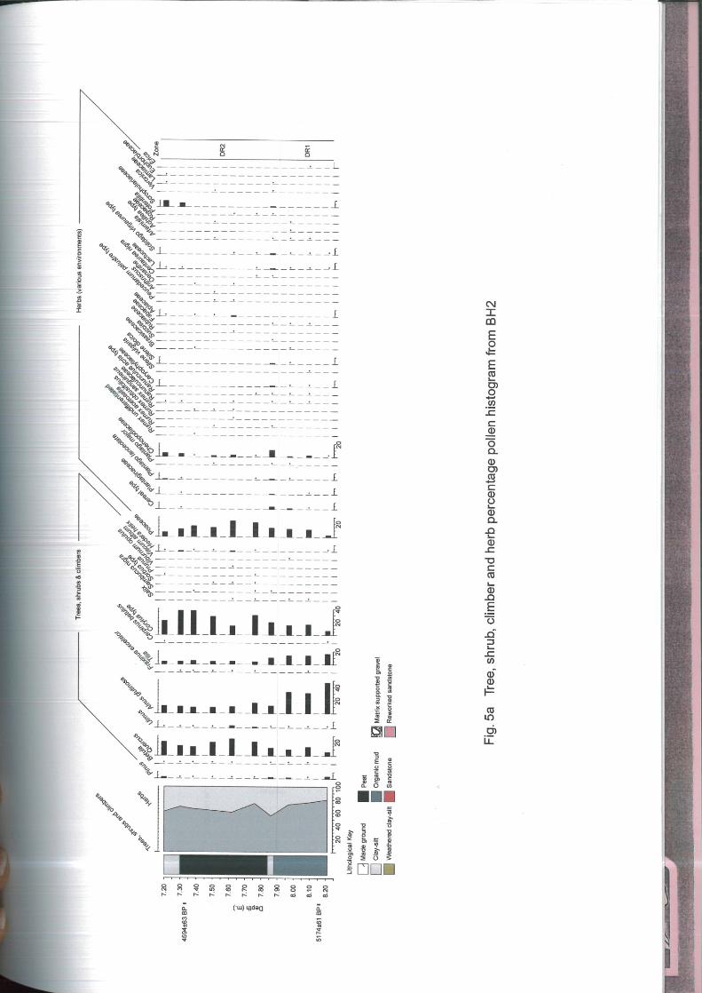
7.5 The results are presented in the form of a pollen diagram drawn using Tilia software
(Grimm 1990) (Fig.s 4a and 4b). Pollen data are expressed as percentages of total
land pollen (TLP). All pollen taxa included in the pollen sum are shown in the
diagram as solid bars. Aquatic taxa were counted outside the pollen sum and
expressed as percentages of total pollen plus aquatics (TPA). Fern spores were
counted outside the pollen sum and expressed as percentages of total pollen plus
ferns (TPF). Algal spores and charcoal fragments are also included in the pollen
diagram, but are shown as actual counts, not percentages. All taxa excluded from
the pollen sum are shown on the diagram as open bars. At the start of the diagram
there is a summary of the changing proportions of pollen of woody and herbaceous
species. The pollen types have been organised into three groups to aid in
interpretation – trees, shrubs and climbers, herbs (various environments), and
marsh and aquatic plants. The groupings of taxa are flexible; some pollen taxa have
members which inhabit a variety of ecological niches. For instance, Ranunculus
acris-type is a large taxon, which includes species typical of grassland (e.g. R. acris,
meadow buttercup, R. bulbosus, bulbous buttercup), but also some wetland species,
such as R. flammula and R. lingua (greater and lesser spearwort). The
Brassicaceae (cabbage family) include many herbs of disturbed ground but also
Rorippa - the water-cresses. Thus some of the flowering herbs included in the ‘herbs
(various environments)’ group may well have grown in marshland.
7.6 In this report, pollen of Corylus-type includes pollen of Corylus avellana (hazel) and
of Myrica gale (bog myrtle). The distinction between pollen of Corylus and Myrica is
not easy to make, Andrew (1984) noted that Myrica pollen can be identified on the
basis of the sloping ‘shoulders’ leading to each pore. All Corylus-type pollen grains
counted in this assessment have been assumed to be Corylus, but it is possible that
some are Myrica. Pollen of Cereal-type was distinguished from that of other grasses
on the basis of size, with all grains >40µm in diameter considered to be in this
group. Some (few) wild grasses also have grains of this size, they are Spartina
anglica (common cord grass), Ammophila arenaria (marram grass), Leymus
Land at Anchor Road/Deanery Road, Bristol
22
© Cotswold Archaeology
arenarius (lyme grass) which are all coastal species, also Glyceria (sweet grass),
which grows in mud by ponds and rivers, and Aira caryophyllea (hair grass) and
some Elytrigia species (couch grasses) which grow in dry sandy places (Moore,
Webb and Collinson 1991). In view of the topographic position of these peats, close
to the River Avon, it is possible that the Cereal-type pollen is that of Glyceria.
7.7 The pollen diagram has been zoned on the basis of changes in the tree pollen
curves. Two assemblages are recognised, Deanery Road 1 (DR1) and Deanery
Road 2 (DR2). The characteristics of these two assemblages are described below.
DR 1 (8.22m – 7.90m) Alnus-Tilia assemblage
7.8 Tree pollen forms between 71% and 82% TLP in this assemblage. Alnus (alder) is
the dominant tree taxon, forming 48% TLP in the basal sample, declining to around
32% TLP at the top of the zone. Tilia (lime) forms 14-16% TLP. Quercus (oak) and
Corylus-type (hazel) fluctuate between 6% and 14% TLP and 7% and 16% TLP
respectively. Pinus (pine), Ulmus (elm) and Betula (birch) are all represented at <2%
TLP. Occasional pollen grains of Fraxinus (ash), Salix (willow) and Viscum album
(mistletoe) occur. The principal herbaceous pollen types are Cyperaceae (sedges)
(7-15% TLP) and Poaceae (grasses) (3-12% TLP). A few Cereal-type grass pollen
grains occur. A range of flowering herbs is present, all at values of <1% TLP
including Plantago lanceolata (ribwort plantain), P. major (greater plantain),
Ranunculus acris-type (buttercup), Silene vulgaris (bladder campion), S. dioica (red
campion), Brassicaceae (cabbage family), Fabaceae (pea family), Lactuceae
(dandelion and related Asteraceae), Solidago virgaurea-type (daisy, aster and
related Asteraceae) and Artemisia (mugwort). A single grain of Erica pollen was
found. Chenopodiaceae (goosefoot family), a taxon associated with both disturbed
ground and halophytic environments, is represented at values of up to 3% TLP.
Occasional pollen grains of the wetland types Lythrum salicaria (purple loosestrife),
and Mentha-type (mints) occur. True aquatics such as Typha latifolia (bulrush),
Sparganium emersum-type (bur reeds, lesser bulrush), Sparganium erectum
(branched bur reed), Alisma plantago-aquatica (water plantain), and Samolus
valerandi (brookweed) are found at frequencies of <1% TPA. Fern spores, including
Pteridium (bracken), Polypodiaceae (polypody fern) and undifferentiated ferns, form
between 15% and 32% TPF; they are most frequent in the basal sample. Occasional
spores of the filamentous green algae Spirogyra occur along with a few spores of
van Geel Type 128. Pollen concentrations are very low in the basal sample (8.21m)

Land at Anchor Road/Deanery Road, Bristol
23
© Cotswold Archaeology
but then rise to around 100,000 grains/cc. Microscopic charcoal fragments >40µm in
length occur throughout the zone at low frequency.
DR 2 (7.90m – 7.20m) Quercus-Corylus assemblage
7.9 In this zone tree pollen is somewhat reduced compared with DR1, fluctuating
between 55% and 74% TLP, this is due to a decline in both Alnus and Tilia, though
increases in Quercus and Corylus-type partly compensate. Around 7.90m Alnus
declines markedly, and forms 9-15% TLP throughout the zone. Tilia declines more
gradually to around 5% TLP above 7.85m. Quercus and Corylus-type both increase
gradually. Frequencies fluctuate between 12 and 27% TLP for Quercus, and
between 14 and 37% TLP for Corylus-type. Pinus and Ulmus are represented
throughout the zone at values of <3% TLP. Occasional grains of Betula, Fraxinus
excelsior, Salix, Sambucus nigra (elder), Sorbus-type (includes whitebeam), Prunus
(cherry), and Hedera helix (ivy) occur. Herbaceous pollen increases slightly,
principally Poaceae which peak at 25% TLP in the middle of the zone (7.62m), and
Cyperaceae which peak at 18% TLP at 7.50m. A few Cereal-type pollen grains
continue to be represented at low frequencies. The range and frequency of most
flowering herbs is very similar to DR1, however, the start of the zone is marked by a
peak in Chenopodiaceae which reach 11% TLP at 7.86m and then fall to values of
<3% TLP before rising to 5-6% TLP above 7.40m towards the top of the zone.
Wetland types are represented mainly by Typha latifolia and Sparganium emersum-
type, the latter reaches 10% TPA at 7.50m. Fern spores are present throughout the
zone at values slightly lower than those of DR1. There is quite a marked increase in
the spores of Spirogyra and of van Geel Type 128 in DR2, and around 7.38m a
number of the distinctive spores of the algae Mougeotia occur. Pollen concentrations
rise markedly in the middle of the zone to values of over 200,000 grains/cc, but fall
back to only 20,000 grains/cc in the upper most sample. Microscopic charcoal is
found throughout DR2 but at very variable frequencies, becoming abundant at
7.76m, then declining markedly above this.
Interpretation
7.10 The peat bed at the site appears to have accumulated in a damp hollow close to the
River Avon and surrounded by trees. The deepest sediments examined for this
report contain a significant inorganic component, which possibly suggests some
active water movement at the site prior to the development of the marsh, and this

Land at Anchor Road/Deanery Road, Bristol
24
© Cotswold Archaeology
also accounts for the low pollen concentration in the basal sample. Peat
accumulation began around 5174 BP, (4220-3790 cal BC) in the early Neolithic
period.
7.11 In zone DR1 the pollen evidence suggests that the marsh was fringed by wet alder
woodland and that beyond this, probably on higher ground, there was extensive dry-
land woodland dominated by lime with some oak and hazel and occasional elm and
ash. Tilia (lime) pollen percentages underestimate the importance of lime in the
vegetation, Tilia is insect pollinated and the large sticky grains are shed close to the
tree. Work by Andersen (1970) suggested that pollen percentages for Tilia needed
to be corrected by a factor of x8, in order to be compared directly with Quercus.
Greig (1982) summarized evidence for the past importance of Tilia in the mid-
Holocene forests of Britain and Europe, using Andersen’s correction factor. The
pollen sum Greig used excluded Alnus and Corylus; if the DR1 data is recalculated
in this way, corrected values for Tilia are between 80% and 90%. According to Greig
(1982), corrected values of Tilia pollen > 60% indicate lime as the major forest
component. It is clear, therefore, that the dry-land woodland around the area at this
time was lime-dominated.
7.12 The marsh itself supported a vegetation of grasses (possibly Phragmites, common
reed) and Cyperaceae (sedges), with some Sparganium (bur reed). There appear to
have been some pools of open water, which supported aquatic communities
including Alisma plantago-aquatica (water plantain), Lemna (duckweed) and
Samolus valerandi (brookweed) as well as the filamentous green algae Spirogyra.
The range of other herbaceous pollen taxa found at low frequency in DR1 include
types which might have grown on the marsh, such as Brassicaceae (cabbage family
– includes water-cresses and cuckoo flower) and Ranunculus acris-type (buttercup,
spearwort). Other taxa may have been associated with the woodland edge such as
the Caryophyllaceae (pink family- including red campion), the Apiaceae (carrot
family- hedge parsley etc) and the Fabaceae (pea family – vetches etc).
7.13 Another group of herbs, which are represented at low frequency, are associated with
disturbed ground, these include Plantago lanceolata and P. major (ribwort and
greater plantain), Rumex (sorrels and docks), Lactuceae (dandelion family and
related Asteraceae), Solidago virgaurea-type (daisy and related Asteraceae) and
Artemisia (mugwort). These herbs are often associated with anthropogenic activity,
however in the case of waterside or estuarine situations disturbance might be the

Land at Anchor Road/Deanery Road, Bristol
25
© Cotswold Archaeology
result of natural processes of erosion resulting in unstable soils. The occurrence of
occasional grains of Cereal-type pollen at low frequencies in the pollen record could
indicate cultivation in the area, but the grasses in this taxon include Glyceria fluitans
(floating sweet grass), a freshwater aquatic grass which may have been growing in
the marsh, or at the edge of the river.
7.14 The presence of pollen of Chenopodiaceae (goosefoot family) in all samples from
zone DR1 is of interest. This is a large family with members growing in a wide range
of habitats, some anthropogenic, others influenced by brackish or salt water. It is
very difficult to distinguish pollen of different species and this has not been
attempted here. This pollen taxon could therefore be representative of plants
growing on salt marshes, strandlines, or anthropogenically disturbed ground. In view
of the situation of the site, close to the tidal River Avon, the presence of
Chenopodiaceae in DR1 may well indicate salt marsh communities in the vicinity.
Solidago virgaurea-type is another taxon which includes some plant species
associated with salt marshes such as Aster tripolium (sea aster). The increase in
pollen of Chenopodiaceae at the start of zone DR2 to 10% TLP occurs at the level
where clay was noted in the pollen sample. This suggests that the site was
influenced by an incursion of seawater bringing mineral material and resulting in
brackish conditions. This did not result in elimination of all the freshwater marsh
plants, Alisma plantago-aquatica (water plantain), for example, continued to be
present, but it may well have been the factor which triggered the decline in Alnus at
the start of DR2. At this stage the fringing alder woods were reduced and, as a
result, increasing pollen of oak and hazel reached the marsh surface. The high
Chenopodiaceae values are not maintained throughout DR2, suggesting that the
incursion was relatively brief, however the alder woods did not recover their former
extent. Between 7.75m and 7.31m the deposits are entirely organic and this also
supports the view that salt water flooding of the site ceased. Above 7.65m there are
increased frequencies of pollen of freshwater aquatics such as Typha latifolia
(bulrush) and Sparganium emersum-type (bur reeds, lesser bulrush) and peaks in
the counts for Spirogyra and Mougeotia, filamentous green algae associated largely
with freshwater conditions (van Geel 1986). The frequency of spores of van Geel
Type 128 also increases. This is a small circular spore with spines, often with a
curved furrow or suture. According to van Hoeve and Hendrikse (1998), it is
indicative of shallow, eutrophic fresh water. At the top of the pollen diagram, above
7.3m, there is a renewed increase in the frequency of Chenopodiaceae pollen (Fig.
5a) and this again correlates with increasing clay in the sediment, suggesting

Land at Anchor Road/Deanery Road, Bristol
26
© Cotswold Archaeology
another episode of flooding by salt or brackish water dated to just after 4594 BP
(3550-3050 cal BC).
7.15 Another significant change that occurs soon after the start of Zone DR2 is the
gradual decline in lime pollen. This is the result of changes in the dry-land
woodlands and does not appear to be related to the decline of alder around the
marsh. It is a much more gradual reduction than that of alder, with lime declining
from 14% TLP at the end of DR1 to 5% TLP by the middle of DR2. Using Greig’s
correction calculations (referred to above), this gives a corrected value for Tilia
pollen in DR2 of between 40% and 60% suggesting (according to Greig 1982) that
lime formed about half the tree cover. Compared with the woods of DR1, lime had
therefore undergone a significant decline. It is possible that this had an
anthropogenic cause; a lime decline is a widely recorded feature in post-Elm Decline
pollen diagrams from England and Wales, though the dates at which it occurs vary.
In mid-Wales, it appears to be rather later than at this site and it has been linked
with Bronze Age human activity (Walker 1993). However, on the Somerset Levels
(Caseldine 1988) a decline in lime follows the initial elm decline, which is dated c.
4800 BP. The date for the start of the decline in lime at the site must be rather
similar to this, as it lies between the two dated horizons of 5174 BP (4220-3790 cal
BC) and 4594 BP (3550-3050 cal BC). Despite the decline, lime remained an
important forest element along with oak in the dry-land woods in the Avon valley.
7.16 The presence of charcoal throughout both zones of the pollen diagram indicates that
anthropogenic activity was present in the area. However, relative charcoal
frequencies are fairly low except at 7.76m where they reach a peak, it may be
significant that this occurs when lime is declining, supporting the view that this
change in forest composition may have been a result of increasing anthropogenic
activity.
Discussion
7.17 The pollen record from the site is extremely important in the context of the Bristol
area. This is the first pollen diagram recording the pre-settlement vegetation of the
Avon valley around Bristol. It provides a record of the history of the Avon woodlands
during the Neolithic period.

Land at Anchor Road/Deanery Road, Bristol
27
© Cotswold Archaeology
7.18 The pollen evidence suggests that the site was freshwater marshland, which was
subject to an incursion of brackish water sometime between 4220 and 3050 cal BC.
This appears to have influenced the alder woods around the marsh, causing them to
be reduced in area or density. This ecological response to brackish/salt water
flooding is similar to that recorded in the pollen diagram from The Sweet Track F site
on the Somerset Levels (Coles, Hibbert and Orme 1973) where a decline in Alnus
pollen occurred prior to the flooding event which resulted in the deposition of the
Lower Wentlooge clay around 5210-4800 cal. BC (Tinsley 2002). The peat at this
site is very compressed, the 14C dates indicate that it formed over a minimum of 240
years but a maximum of 1170 years. It is therefore possible, given the resolution of
the pollen sampling, that other short-lived incursions may have taken place which
have not been picked up.
7.19 The pollen evidence demonstrates the importance of lime in the dry-land woodlands
of the Avon valley between 4220 and 3050 cal. BC. The significance of lime as a
forest component in the mid-Holocene woodlands of England and Wales has been
underestimated in the past owing to the problems of lime pollen representation
discussed above. However, evidence suggests it was probably widespread in the
South Gloucestershire and North Somerset area. A pollen diagram from Walton
Moor in the Gordano valley, North Somerset, has values for lime of around 10% total
pollen (uncorrected) in the mid-Holocene (Jeffries, Willis and Yem 1968). A buried
land surface on the Avon Levels of South Gloucestershire, which is dated between
3300-2200 cal. BC and 2930-2460 cal. BC, has lime frequencies of 5-10% TLP
(uncorrected) (Tinsley 1999). It is therefore likely that lime was the major forest
dominant around both of these sites. The decline in Tilia pollen, which starts around
the DR1/DR2 boundary at the site, reflects the gradual opening up of the lime-
dominated woodlands as a result of human activity during the Neolithic. In view of
the local importance of the site, it would be very useful to have a 14C date for the
lime decline around the DR1/DR2 zone boundary.
7.20 It is clear from the pollen evidence that elm was only a minor forest component in
the late Mesolithic/Neolithic woodlands of the Avon valley. Values for Ulmus pollen
are low in DR1 and remain low at the start of DR2. There is no obvious Elm Decline
horizon, a feature that is recognised at sites throughout Britain and dated to around
5000 BP (c. 3700 cal. BC). On the Somerset Levels, to the south, the first major
decline in elm has been dated at a number of sites to around 4800 BP, though some
dates are as early as 5300 BP (Caseldine 1988). The low values for Ulmus pollen in
Land at Anchor Road/Deanery Road, Bristol
28
© Cotswold Archaeology
the earliest peat which formed at the site around 5174 BP (4220-3790 cal BC)
suggest that the initial Elm Decline had either already taken place by this time, or
that elm was an insignificant contributor to the local forests compared to lime. There
is a temporary increase in Ulmus pollen in the middle of DR2, this occurs after the
decline in Tilia pollen, and it may simply indicate that the few elm trees present in
the woods were able to flower more freely as lime declined in frequency.
7.21 During the later prehistoric period, and during historic times the lime-dominated
woodlands of the Avon valley were reduced even further, but ancient woodland
remains today on the steep slopes of the Avon Gorge on its western side. Tilia
cordata (small leaved lime) is still an important species in some of the areas of
ancient coppice on the side of the gorge and in Leigh Woods. Rackham (1982), in
an account of the ecology and historical features of Leigh Woods, suggested that
lime was likely to have been the dominant species in the wildwood of this area. The
pollen diagram from this site supplies the evidence to support this assertion. The
present Avon Gorge woodlands include Prunus avium (wild cherry) and rare species
of whitebeam (Sorbus); it is interesting to note that both Sorbus and Prunus pollen
are recorded at very low frequency in the pollen diagram. Thus this site has
demonstrated a link between the woodlands which persist in the Gorge today and
those which grew in the valley of the Avon in Neolithic times.
8. PLANT MACROFOSSIL ANALYSIS
Julie Jones
Department of Geography, University of Bristol
Methods
8.1 As the samples were recovered from borehole tubes, they were of limited size,
100ml/95g (7.35-7.45m) and 75ml/80g (7.75-7.85m). They were soaked in warm
water and then sieved through a nest of sieves to a minimum mesh size of 250µm.
The bulk of both samples were mineral with limited organic preservation and in both
samples much of the organic matter was composed of small unidentifiable
fragments with dimensions of <1mm. However a limited assemblage of seeds was

Land at Anchor Road/Deanery Road, Bristol
29
© Cotswold Archaeology
recovered from each sample, the uppermost sample, 7.35-7.45m, showing the
better preservation. Occasional fragments of beetle and cladoceran ephyppia
(water-flea egg cases) were also noted. Full details are shown in Table 5.
Nomenclature and habitat information is based on Stace (1991).
Results
7.35-7.45m below ground surface
8.2 The organic matter in this sample was very fragmented, of small dimensions from
500µm - 1mm, with many of the seeds present also fragmented. Some remains had
lost the outer seed coat, e.g Chenopodiaceae indet (Goosefoot family), which meant
that not all seeds could be identified to species level. However the limited
assemblage suggests a predominantly wet environment with areas of open water
suggested by the presence of aquatic species such as pondweed (Potamogeton sp),
horned pondweed (Zanichellia palustris) and water crowfoot (Ranunculus subg.
Batrachium). Horned pondweed is a species of still to moderate flow in streams and
lakes in depths of up to 2m and includes slightly brackish water conditions. Both
water crowfoot and pondweed include some species, which can tolerate brackish
water conditions, but are primarily fresh water plants. Glaucous Bulrush
(Schoenoplectus tabernaemontani) can also tolerate brackish soils in lakes, pools
and ditches in depths of up to 0.5m, with common clubrush (Schoenoplectus
lacustris), a species of still to moderate flow in freshwater lakes, ponds and streams.
This can occur in association with water plantain (Alisma sp), a freshwater plant of
shallow margins. Overall the assemblage suggests a freshwater environment with
still to moderate water flow, but with a suggestion of brackish water influence.
7.75-7.85m below ground surface
8.3 The assemblage from this sample was more limited and preservation was poor.
Fragments of organic matter were mostly <1mm and largely unidentifiable.
Macrofossils were fragmented, or particularly in the case of the Alisma species, had
lost their outer casing. The most commonly occurring species were water plantain
and water crowfoot, as in the previous sample, plus single bulrush (Typha sp.) and
rush (Juncus sp.) seeds suggesting a predominantly freshwater environment. The
presence of greater plantain (Plantago major) also suggests a drier grassy or rough
ground habitat.
Land at Anchor Road/Deanery Road, Bristol
30
© Cotswold Archaeology
Discussion
8.4 The evidence provided by the samples examined, although limited, points to these
sediments being laid down in a predominantly freshwater environment, with some
indication of brackish water influence in the sample from 7.35-7.45m. The
occurrence of a thin lens of organic mud within Unit 3, suggests an episode of
slightly wetter conditions which temporarily halts the development of peat growth.
The presence of brackish water indicators in the peat above this organic mud may
suggest that this was a marginal area, perhaps in a transitional zone at the limit of
an upper saltmarsh, but that at this location the environment was largely freshwater.
There is no evidence for the age of these deposits and no suggestion of human
activity associated with them.
8.5 It is difficult to compare the results with the evidence provided by pollen and diatom
analyses (from 10mm spits), due to the thickness of the plant macro sample
(100mm). However, it may be possible to correlate the sample from 7.35-7.45m with
the deepest diatom sample from 7.35-7.36m, which suggests that the sediments
accumulated under brackish conditions. Here the most abundant diatoms are
species of benthic brackish water taxa and planktonic marine species. The pollen
record from 7.38-7.39m shows a small increase in Chenopodiaceae also suggesting
a possible increase in brackish conditions towards the top of the sequence
examined.
8.6 There are no diatom samples from an equivalent depth to the lowest sample
examined (7.75-7.85m bgs) and the pollen sample occurs just below this level at
7.86-7.87m bgs, although again a peak in Chenopodiaceae pollen occurs.

Land at Anchor Road/Deanery Road, Bristol
31
© Cotswold Archaeology
Depth below surface 7.35-7.45m 7.75-7.85m
Sample size (ml/g) 100/95 75/80 Habitat
CHARACEAE
Chara spp Stonewort 2 A
RANUNCULACEAE
Ranunculus subg. Batrachium
(DC.)A.Gray
Water Crowfoot 20 10 APR
CHENOPODIACEAE
Chenopodium rubrum/glaucum Red/Oak-leaved Goosefoot 2 CDs
Chenopodiaceae indet 3
POLYGONACEAE
Rumex sp Dock 1 frag DG
PLANTAGINACEAE
Plantago major L. Greater Plantain 1 CDG-o
ALISMATACEAE
Alisma sp Water Plantain 4 11 APR
POTAMOGETONACEAE
Potamogeton sp Pondweed 1 APR
ZANICHELLIACEAE
Zanichellia palustris L. Horned Pondweed 7 APR-fresh
&brackish
JUNCACEAE
Juncus sp Rush 1 GMRw
CYPERACEAE
Carex spp Sedge 1 +2f GMPRW
Schoenoplectus lacustris (L.)Palla Common Club-rush 5 BPR-
shallow
Schoenoplectus tabernaemontani
(C.Gmelin)Palla
Grey Club-rush 5 BPRs-
marshes,
duneslacks
& wet peaty
places
mostly near
sea
Schoenoplectus/Scirpus spp Club-rush/ 9f
POACEAE
Poaceae indet Grass 1
TYPHACEAE
Typha sp Bulrush 1 PR-reed,
swamp
Other remains
Beetle fragments <20 <5
Cladoceran ephyppia 4 2
Key: Habitats A: Aquatic. B. Bankside. C: Cultivated/Arable. D: Disturbed. G: Grassland. M: Marsh. P: Ponds, ditches -
stagnant/slow flowing water. R: Rivers, streams. o: open habitats. s: coastal. w: wet/damp soils
Table 5: Waterlogged plant remains.
Land at Anchor Road/Deanery Road, Bristol
32
© Cotswold Archaeology
9. DISCUSSION
9.1 This section is divided into two parts. In the first a palaeoenvironmental history of the
site is proposed, based on the data presented in Sections 2-8 above. Following this,
the questions set by the assessment report (Wilkinson 2001), and with which this
document began are addressed.
Palaeoenvironments
9.2 The rocks (Unit 6) on which the sequence sits are of Triassic date and formed in
riverine and alluvial fan environments at 250-200 million years ago. Since that date
the upper 2-4m of these sandstones have weathered forming unconsolidated
medium and fine sands (Unit 5). Within at least the top 0.5m of these deposits soil
formation has taken place, as demonstrated by magnetic susceptibility evidence
(χfd), although exactly when this occurred is open to question. The upper surface of
the unconsolidated sands has undergone more intense and probably more recent
(?late Quaternary) weathering as demonstrated by a minor peak in low frequency
magnetic susceptibility and morphological changes. Nevertheless an unconformity
and consequently a temporal hiatus exist at the top of the unit. The overlying clays
and silts (Unit 4) would appear, on the basis of their morphology to have formed in
an aquatic environment, probably during the first half of the Holocene (c. 9300-4000
BC). The complete absence of Foraminifera in a series of samples from these
deposits can tentatively be suggested as indicating that accumulation was in a
freshwater environment (Foraminifera do not inhabit freshwater environments). If so
this is likely to have been on the floodplain of the early Holocene river Avon, which
was not subject to tidal influences in this part of its reach before the mid Holocene.
9.3 Sometime around 4220-3790 cal. BC the site became marginalized from the river
Avon. This may have been caused by deposition on the floodplain outstripping the
rate of base level rise, or a migration of the river channel away from the site; the
present data do not allow a firm interpretation. However, the result was that organic
muds began to develop on the floodplain margin (Unit 3). Pollen preserved in the
muds suggests that pools of open water existed on the site, fringed by alder
woodland. On higher ground, perhaps even the slopes of Brandon Hill, lime

Land at Anchor Road/Deanery Road, Bristol
33
© Cotswold Archaeology
woodland existed with lesser forest components of oak, hazel and elm. Although
there is very limited evidence for human impact during the accumulation of the
organic muds from the palynological evidence (i.e. pollen grains that could be arable
weeds, cereals and indicators of ground disturbance were all found, but could also
be a result of increasing tidal influence in the region), there is a suggestion from the
magnetic data which indicate that people were active in the landscape. A sustained
peak in low frequency magnetic susceptibility from the middle of the organic muds is
most likely to have been caused by the deposition of ash on the floodplain margin.
This is unlikely to have come from the immediate vicinity of the sample site, but
could be the result of Landnam-type clearances (sensu Iversen 1941) further away,
which are typical of the early Neolithic period in southern England. These
clearances, being of relatively short duration are also notoriously difficult to
recognise in pollen diagrams, particularly where close interval sampling has not
been undertaken (as here). During the period of the early Neolithic represented by
the accumulation of the organic muds, the surrounding alder woodland gradually
declined. This was probably the result of minor incursions by tidal waters – to which
alder is not tolerant. One of these events is recognised in the organic carbon record
as a trough between 7.98-8.04m.
9.4 At approximately the contact between the organic mud and the peat (c. 7.85m) there
is a significant change in the pollen assemblage. The alder woodland declines still
further, while a peak occurs in Chenopodiaceae. As many species of the latter family
are characteristic of intertidal environments, a tidal incursion is the most likely
explanation of the changes. However, this would seem to have been short-lived as
the pollen of taxa of freshwater preference increase in overlying samples, while only
freshwater plants are found in the plant macrofossil sample from this part of the
stratigraphy. It would therefore seem that although the site was located close to the
high tide mark (probably Highest Astronomical Tide [HAT]), peat growth rapidly
outstripped sea level rise. Further vegetation changes also occurred during the
accumulation of the peat that have nothing to do with tidal processes. A decline in
lime pollen, accompanied by a peak in microscopic charcoal suggests that people
were impacting on the forest of the surrounding areas by about 3500 BC. However,
as would be expected in a marginal, boggy area the plant macrofossil evidence
suggests that there was no local impact.
9.5 Sometime between 3550-3050 cal. BC the peat ceased forming and instead
accumulation became dominated by mineral silts and clays (Unit 2). Several lines of

Land at Anchor Road/Deanery Road, Bristol
34
© Cotswold Archaeology
evidence suggest that this was the result of further sea level rise with which peat
growth could not keep pace. Diatom assemblages indicate the rapid increase in
importance of marine planktonic forms across this stratigraphic boundary and
generally suggest increasingly saline conditions. Similarly Cyperaceae dominates
pollen assemblages towards the top of the peat, which are here likely to be salt
marsh forms. The plant macro remains found in this part of the sequence, although
of freshwater preference can also tolerate brackish conditions. The transition to salt
marsh was nevertheless gradual as is shown by the slow reduction in organic
carbon content between the peat and overlying mineral sediments. By the time the
lowest mineral sediments of Unit 2 were being deposited, Foraminiferal evidence
suggests that the site lay on either the middle or low saltmarsh zone.
9.6 There are further indications of sea level fluctuation higher in the mineral clays and
silts of Unit 2. Between 6.50-6.80m organic carbon contents rise to levels
comparable with the organic muds of Unit 4, suggesting a more marginal situation
with respect to the foreshore. Foraminiferal evidence also suggests that during this
episode the site was on either the high or mid saltmarsh zone (c.f. low-mid
saltmarsh before), while the diatom assemblages include freshwater, aerophilous
elements and chrysophyte cysts as well as brackish and poorly preserved marine
forms. Thus it would appear that the position of the site had risen in relation to
relative sea level. Indeed the aerophilous diatoms and chrysophyte cysts indicate
the input of terrestrial material, a suggestion that is further supported by a large peak
in low frequency magnetic susceptibility which may be indicative of local burning,
and thus possible human use of the intertidal zone. Although it is impossible to date
this sea-level event, it can very tentatively be assigned to the Bronze Age, when the
rate of sea level rise had slowed in several sea level curves in southern Britain (e.g.
Long, Scaife and Edwards 2000).
9.7 A further episode of ash input into the salt marsh that is suggestive of burning
occurs at about 6.20m, but this time there is no other supporting evidence for a fall
in relative sea level. Subsequently the area would appear to have remained a
saltmarsh until ‘reclaimed’ in either the later medieval or post-medieval period, when
a substantial thickness of sediment was deliberately deposited (Unit 1) on the site to
raise it above the zone of tidal influence.
Land at Anchor Road/Deanery Road, Bristol
35
© Cotswold Archaeology
Addressing the research questions
How old was the stratigraphy found below the ‘made ground’ in which the medieval
and post-medieval remains investigated by Cotswold Archaeological Trust were
found?
9.8 This question can be definitively answered only in relation to the peat as no artefacts
or organic material suitable for 14C dating were found from any other deposit. The
peat formed in the early to middle Neolithic some time between 4220-3050 cal. BC.
It is very likely that the mineral silts and clays (Unit 4) beneath the peat date to the
middle or early Holocene, while it is possible that the relatively organic-rich zone of
the upper mineral silts and clays (Unit 2), between 6.50-6.80m was accreting in the
Bronze Age.
How did the peat revealed in the borehole studies form – in a brackish or freshwater
environment?
9.9 The peat is actually a complex of organic muds and true peat. These began to
accumulate in a freshwater environment at the margin of the Avon floodplain in the
early Neolithic period. At around 3500 cal. BC the peat was subject to marine
incursion. Subsequently its growth outstripped that of sea-level rise and it continued
to form in a freshwater environment. Soon before it stopped developing around
3550-3050 cal. BC it became part of the intertidal zone and thus subject to marine
influence.
Were the apparently weathered layers noted during the assessment in, and at the
surface of clays and silts, which occur below the ‘made ground’, the result of
terrestrial processes or merely localised discolourations of the intertidal/alluvial
stratigraphy?
9.10 Three of these zones were examined in the laboratory studies, one at c. 5.70m, a
second at 6.14-6.18m and the last at c. 6.50-6.80m. The last two at least appear to
have been caused by the short-lived operation of terrestrial processes in the
saltmarsh. Both contain possible evidence for human manipulation of the marsh in
the form of burning as expressed by peaks in the low frequency magnetic
susceptibility curve.

Land at Anchor Road/Deanery Road, Bristol
36
© Cotswold Archaeology
Was there any direct or indirect evidence of human activity in the terrestrial
sediments (i.e. peats or ‘surfaces’ in the silts and clays)?
9.11 As stated in the answer to the previous question there is indirect evidence for human
use of the saltmarsh, or at least burning in the local environment during accretion of
Unit 2. There is also evidence of further burning during the early Neolithic period,
causing a sustained peak in low frequency magnetic susceptibility between c. 8.00-
8.14m. The magnitude of this is such that it is likely that burning was at some
distance from the sample site. Palynological evidence may support this assertion as
possible grains of cereals, weeds and other indicators of ground disturbance were
also found at this level. A more definitive palynological indicator of human activity –
although again away from the sample site – is provided by the decline in lime pollen
from 7.90m upwards and the concomitant increase in microscopic charcoal and
Chenopodiaceae pollen. These last are likely to have been the due to clearance of
lime woodland for agriculture during the middle Neolithic period.
Did the clays and silts represent accumulation in brackish or freshwater
environments?
9.12 The lower silts and clays of Unit 4 are likely to have formed in a freshwater
environment at the margins of the Avon floodplain. However, the evidence for this
hypothesis is only slight, i.e. the absence of Foraminiferal tests from samples of this
deposit and the fact that there are no brackish water indicators in the lower portion
of the peats of Unit 3, with which Unit 4 has a conformable (i.e. time continuous)
boundary. In contrast the clays and silts of Unit 2 formed in a brackish, intertidal
environment, albeit with episodic exposure to terrestrial processes.
10. CONCLUSIONS
10.1 The investigation of the sequence at the site has provided important new
palaeoenvironmental data, particularly given that there are no previous pollen
diagrams from central Bristol, while those from surrounding areas (e.g. Tinsley
1999) are from stratigraphy of a later date. These data are at least of regional
Land at Anchor Road/Deanery Road, Bristol
37
© Cotswold Archaeology
significance. As has already been pointed out in Section 7, the origins of the
nationally famous Leigh Wood, argued by Rackham (1982) to be one of the few
remaining areas of ‘wildwood’ in England are now firmly established as a result of
palynological analysis here. The broad-leaved lime that characterises Leigh Wood
today was the dominant forest tree of the middle Holocene at this site, comprising
perhaps 80% of trees in the wood. However, even these temporally distant
woodlands were subject to modification through the actions of people. Both
palynological and sedimentological evidence suggests that clearance in, and
burning of the surrounding lime woods took place in the Neolithic period.
10.2 A second aspect of the investigation that has proved significant is the data relating
to sea level. The sea level history of the Severn Estuary and tributary rivers is
presently a subject of intense academic interest (e.g. Bell, Caseldine and Neumann
2000; Haslett et al 2001) given recent archaeological discoveries in the intertidal
zone and future worries with regard to the affects of global sea level rise. Evidence
from the site suggests that rising sea levels first directly impacted upon the site
around 3500 cal. BC, although the initial affects were short-lived. Subsequently,
between 3550-3050 cal. BC the site was incorporated within the intertidal zone. The
fact that it was possible to obtain a 14C AMS date of relatively high precision from the
demonstrably conformable contact between the terrestrial/freshwater peat of Unit 3
and the brackish silts and clays of Unit 2 means that the project has added a further,
high resolution sea-level index point (sensu Shennan 1989) to the Severn Estuary
sea level database (see Haslett et al. 2001) (Fig. 5).
10.3 The methodology employed by the project has been demonstrated to be robust by
the results obtained. Archaeologists in particular are often reluctant to employ
borehole surveys because of the limited window that a 100mm diameter (or less)
core provides into the past (e.g. Locock 2001). It is true that boreholes are unlikely
to record the presence of structural remains. However, when stratigraphic records
from boreholes are combined with relatively high resolution sedimentological and
micro-biological analyses of the kind carried out on these samples, information
relating to other aspects of human activity, not normally recovered in ‘standard’
archaeological excavations are revealed (e.g. evidence of sub-regional forest
modification and saltmarsh exploitation). In the case of sites where thick
stratigraphic sequences and a high water table are expected, borehole surveys are
the only realistic, safe and cost effective means of investigation.

Land at Anchor Road/Deanery Road, Bristol
38
© Cotswold Archaeology
10.4 The one major problem area experienced in the investigation of the sequence has
been in the establishment of a chronology. While it was relatively straightforward to
obtain 14C dates for the organic part of the sequence, the mineral strata remain
undated, except by reference to the former. This is particularly unfortunate given that
several episodes of human saltmarsh interference have tentatively been identified in
the sequence. Dating techniques other than 14C have been successfully applied to
mineral-dominated intertidal strata including Lead-210 and optically stimulated
luminescence (OSL). However, the former is only applicable to the last few hundred
years and the latter is impractical from borehole samples. Future studies should
investigate the possibility of using temporal markers to date such strata similar to
geochemical evidence for the rise in lead recognised in intertidal stratigraphy of the
Somerset Levels as a result of the Roman led extraction industry (Haslett et al.
1998).
11. ACKNOWLEDGEMENTS
The authors would like to thank Mark Collard, who managed the project for Cotswold
Archaeological Trust (CAT), Franco Vartuca (CAT), who supervised the drilling of
the archaeological boreholes and Peter Moore (CAT) for drawing Figs. 1 and 2.
Vanessa Straker (English Heritage) and Bob Jones (Bristol City Council) are
thanked for advice both during and after fieldwork, and Myra Wilkinson-van Hoek for
undertaking much of the laboratory-based sedimentological analysis.
12. BIBLIOGRAPHY
Allen, J.R.L. (1999) ‘Geological impacts on coastal wetland landscapes: some general
affects of sediment autocompaction in the Holocene of northwest Europe.’ The
Holocene 9, 1-12.
Andersen, S.Th. (1970) ‘The relative pollen productivity and pollen representation of North
European trees, and correction factors for tree pollen spectra.’ Danmarks geologiske
Undersøgelse. Series 2. 96, 1-99.
Land at Anchor Road/Deanery Road, Bristol
39
© Cotswold Archaeology
Andrew, R. 1984 A Practical Pollen Guide to the British Flora. Technical Guide 1.
Quaternary Research Association, Cambridge.
Bell, M.G. 2001 ‘Environmental archaeology in the Severn Estuary: progress and prospects.’
In Rippon, S. (Ed.) Estuarine Archaeology: the Severn and beyond. Archaeology in
the Severn Estuary 11. Severn Estuary Levels Research Committee, Exeter, 69-
104.
Bell, M.G., Caseldine, A. and Neumann, H. 2000 Prehistoric intertidal archaeology in the
Welsh Severn Estuary. CBA Research Report 120, Council for British Archaeology,
York.
Bennett, K. D. 1994 Annotated catalogue of pollen and pteridophyte spores of the British
Isles. Department of Plant Sciences, University of Cambridge, Cambridge.
Bronk Ramsey, C. 2000 OxCAL 3.5. Research Laboratory for Archaeology and the History
of Art, Oxford.
Caseldine, A. E. 1988 ‘A wetland resource: the evidence for environmental exploitation in the
Somerset Levels during the prehistoric period.’ In Murphy P. and French C. (Eds.)
The Exploitation of Wetlands. BAR British Series 186, British Archaeological
Reports, Oxford, 239-265.
CAT 2000 Land to the north of Anchor Road, Bristol. Archaeological Evaluation. CAT
typescript report 001198
CAT 2001 Land to the north of Anchor Road, Bristol. Archaeological Excavation and
Recoprding. CAT typescript report 01066
Coles, J.M., Hibbert, F.A. and Orme, B.J. 1973 ‘Prehistoric Roads and Tracks in Somerset,
England: 3. The Sweet Track.’ Proceedings of the Prehistoric Society 39, 256-293.
Denys, L. 1992 A check list of the diatoms in the Holocene deposits of the Western Belgian
Coastal Plain with a survey of their apparent ecological requirements: I. Introduction,
ecological code and complete list. Service Geologique de Belgique. Professional
Paper No. 246.

Land at Anchor Road/Deanery Road, Bristol
40
© Cotswold Archaeology
Gale, S.J. and Hoare, P.G. 1991 Quaternary sediments: petrographic methods for the study
of unlithified rocks. Belhaven, London.
van Geel, B. 1986 ‘Application of fungal and algal remains and other microfossils in
palynological analyses.’ In Berglund, B. (Ed.) Handbook of Holocene Palaeoecology
and Palaeohydrology. John Wiley, Chichester, 497-500.
Geotechnical Engineering Limited 2000 Beaufort House, Bristol. Ground Investigation. GEL
report 10971
Greig J. 1982 ‘Past and present lime woods of Europe.’ In Bell, M.G. and Limbrey, S. (Eds.)
Archaeological Aspects of Woodland Ecology. BAR International Series 146, British
Archaeological Reports, Oxford, 23-57.
Grimm, E. 1990 Tilia and Tilia.graph: PC spreadsheet and graphics software for pollen data.
INQUA COMM. Stud. Holocene Working Groups on Data-handling Methods
Newsletter 4, 5-7.
Haslett, S.K., Davies, P., Curr, R.H.F., Davies, C.F.C., Kennington, K., King, C.P. and
Margretts, A.J. 1998 ‘Evaluating late-Holocene relative sea-level change in the
Somerset Levels, southwest Britain.’ The Holocene 8, 197-207.
Haslett, S.K, Davies, P. and Strawbridge F. 1997 ‘Reconstructing Holocene Sea-level
Change in the Severn Estuary and Somerset Levels: The Foraminifera Connection.’
Archaeology in the Severn Estuary 8, 29-40.
Haslett, S.K., Davies, P., Davies, C.F.C., Margetts, A.J., Scotney, K.H., Thorpe, D.J. and
Williams, H.O. 2001 ‘The changing estuarine environment in relation to Holocene
sea-level and the archaeological implications.’ In Rippon, S. (Ed.) Estuarine
Archaeology: the Severn and beyond. Archaeology in the Severn Estuary 11.
Severn Estuary Levels Research Committee, Exeter, 35-54.
Hendey, N.I. 1964 An Introductory Account of the Smaller Algae of British Coastal Waters.
Part V. Bacillariophyceae (Diatoms). Ministry of Agriculture Fisheries and Food,
Series IV.

Land at Anchor Road/Deanery Road, Bristol
41
© Cotswold Archaeology
Heyworth, A. and Kidson, C. 1982 ‘Sea-level changes in southwest England and Wales.’
Proceedings of the Geologist’s Association 93, 91-112.
van Hoeve, M.L. and Hendrikse M. 1998 A study of non-pollen objects in pollen slides: the
Types as described by Dr Bas van Geel and colleagues. Utrecht.
Hustedt, F. 1930-1966 Die Kieselalgen Deutschlands, Oesterreichs und der Schweiz unter
Berucksichtigung der ubrigen Lander Europas sowie der angrenzenden
Meeresgebeite. In Dr. L. Rabenhorsts Kryptogamen-Flora von Deutschland,
Oesterrech und der Schweiz 7, Parts 1-3.
Hustedt, F. 1953 ‘Die Systematik der Diatomeen in ihren Beziehungen zur Geologie und
Okologie nebst einer Revision des Halobien-systems.’ Sv. Bot. Tidskr. 47, 509-519.
Hustedt, F. 1957 ‘Die Diatomeenflora des Fluss-systems der Weser im Gebiet der
Hansestadt Bremen.’ Ab. naturw. Ver. Bremen 34, 181-440.
Iversen, J. 1941 ‘Landnam i Danmarks stenalder.’ Danmarks Geologishe Undersøgelse
Series II 66, 1-67.
Jefferies, R.L., Willis, A.J. and Yem, E.W. 1968 ‘The Late- and Post-glacial history of the
Gordano valley, North Somerset.’ New Phytologist 67, 335-348.
Krammer, K. and Lange-Bertalot, H. 1986-1991 Bacillariophyceae. Gustav Fisher Verlag,
Stuttgart.
Locock, M. 2001 ‘Archaeological prospection and evaluation in the Severn Levels, 1989-
1999.’ In Rippon, S. (Ed.) Estuarine Archaeology: the Severn and beyond.
Archaeology in the Severn Estuary 11. Severn Estuary Levels Research Committee,
Exeter, 131-144.
Long, A.J., Scaife, R.G. and Edwards, R.J. 2000 ‘Stratigraphic architecture, relative sea-
level, and models of estuary development in southern England: new data from
Southamton Water.’ In Pye, K. and Allen, J.R.L. (Eds.) Coastal and estuarine
environments: sedimentology, geomorphology and geoarchaeology. Special
Publication 175, Geological Society, London, 253-279.

Land at Anchor Road/Deanery Road, Bristol
42
© Cotswold Archaeology
Moore, P.D., Webb, J.A., and Collinson, M.E. 1991 Pollen Analysis. 2nd edition. Blackwell
Scientific Publications, Oxford.
Murray, J.W. 1973 Distribution and Ecology of Living Benthic Foraminiferids. Heinemann,
London
Murray, J.W. 1979 British Nearshore Foraminiferids. Academic Press, London
Murray, J.W. 1991 Ecology and Palaeoecology of Benthic Foraminifera. Longman Scientific,
London.
Rackham, O. 1982 ‘The Avon Gorge and Leigh Woods.’ In Bell, M.G. and Limbrey, S. (Eds.)
Archaeological Aspects of Woodland Ecology. BAR International Series 146, British
Archaeological Reports, Oxford, 23-57.
Shennan, I. 1989 ‘Holocene crustal movements and sea-level changes in Great Britain.’
Journal of Quaternary Science 4, 77-89.
Stace, C. 1991 New Flora of the British Isles. Cambridge University Press, Cambridge
Stein, J.K. and Teltser, P.A. 1989 ‘Size distributions in artefact classes: combining macro-
and micro-fractions.’ Geoarchaeology 1, 1-30.
Stockmarr, J. 1971 ‘Tablets with spores used in absolute pollen analysis.’ Pollen et Spores
13, 615.
Stuiver, M., Reimer, P.J., Bard, E., Beck, J.W., Burr, G.S., Hughen, K.A., Kromer, B.,
McCormac, F.G., van der Plicht, J. and Spurk, M. 1998 ‘INTCAL98 radiocarbon age
calibration 24,000-0 cal. BP.’ Radiocarbon 40, 1041-1084.
Thompson, R. and Oldfield, F. 1986 Environmental magnetism. Allen and Unwin, London.
Tinsley, H.M. 1999 ‘Seabank to Pucklechurch Pipeline: Pollen Analysis of upper and lower
buried land surface horizons from Farm Lane Field 136, Trench B east (west facing
section).’ Unpublished Report for Entrepose Laing.

Land at Anchor Road/Deanery Road, Bristol
43
© Cotswold Archaeology
Tinsley, H.M. 2002 ‘Pollen analysis of peat samples from Borehole A Shapwick Heath,
Somerset.’ Unpublished Report for the Shapwick Project.
Troels-Smith, J. 1955 ‘Characterisation of unconsolidated sediments.‘ Danmarks Geologishe
Undersøgelse, Raekke IV 3, 38-73.
Tucker, M.E. 1982 Sedimentary rocks in the field. Wiley, Chichester.
Walker, M.J.C. 1993 ‘Holocene (Flandrian) vegetation change and human activity in the
Carneddau area of upland mid-Wales.’ In Chambers, F.M. (Ed.) Climate Change
and Human Impact on the Landscape. Chapman and Hall, London.
Wilkinson, K.N. 2001 ‘Land to the North of Anchor Road, Bristol: Preliminary Stratigraphic
Report’. in CAT 2001

Land at Anchor Road/Deanery Road, Bristol
44
© Cotswold Archaeology
APPENDIX A: NOTES ON POLLEN TYPES
The taxonomic level to which pollen grains can be identified varies; some can be identified to species level,
others to family and others to group. This report mainly follows theconventions used by Bennett (1994). The
following notes may be helpful:
Corylus-type includes Corylus avellana and Myrica gale.
Lactuceae includes Cichorium intybus, Lapsana communis, Hypochaeris, Leontodon, Picris, Lactuca (some spp)
Cicerbita alpina, Taraxacum, Crepis, Pilosella, Hieracium.
Solidago virgaurea-type includes Filago, Antennaria dioica, Gnaphalium, Inula, Pulicaria, Solidago virgaurea,
Aster, Erigeron, Bellis perennis, Senecio, Tephroseries, Tussilago farfara, Petasites hybridus, Bidens,
Eupatorium cannabinum.
Achillea-type includes Tanacetum vulgare, Otanthus maritimus, Achillea, Anthemis, Leucanthemum vulgare,
Matricaria, Tripleurospermum.
Ranunculus acris-type includes Ranunculus undifferentiated, Clematis vitalba, Pulsatilla vulgaris, Anenome
nemerosa.
Mentha-type includes Clinopodium, Origanum vulgare, Thymus, Lycopsus europaeus, Mentha, Salvia
.
Peucedanum palustre-type includes Bunium bulbocastanum Selinium carvifolia, Angelica sylvestris,
Peucedanum.
Sparganium emersum-type includes Sparganium undifferentiated, Typha angustifolia.
Cereal-type includes all grass pollen grains greater than 40 microns in diameter; this includes the cultivated
grasses (cereals) and Glyceria, Aira caryophyllea, Ammophila arenaria, Leymus arenarius, Elytrigia.