lakes entrance foreshore management plan · • the old slipway site– redevelopment of this site...
TRANSCRIPT
LAKES ENTRANCE
FORESHORE MANAGEMENT PLAN
East Gippsland Shire Council
Department of Sustainability and Environment
October 2012
Lakes Entrance Foreshore Management Plan Department of Sustainability and Environment and East Gippsland Shire Council
Page 1
Copies and further information:
Additional copies and further information regarding management of Lakes Entrance foreshore are available from the Department of Sustainability and Environment’s Bairnsdale Office or East Gippsland Shire Council offices in Bairnsdale and Lakes Entrance:
Department of Sustainability and Environment
574 Main Street, Bairnsdale, VIC. 3875
03 5152 0400
East Gippsland Shire Council
Bairnsdale Corporate Centre
273 Main Street, Bairnsdale Vic 3875
or
Lakes Entrance Library and Business Centre
Mechanics Street, Lakes Entrance Vic 3909
1300 555 886 or 03 5153 9500
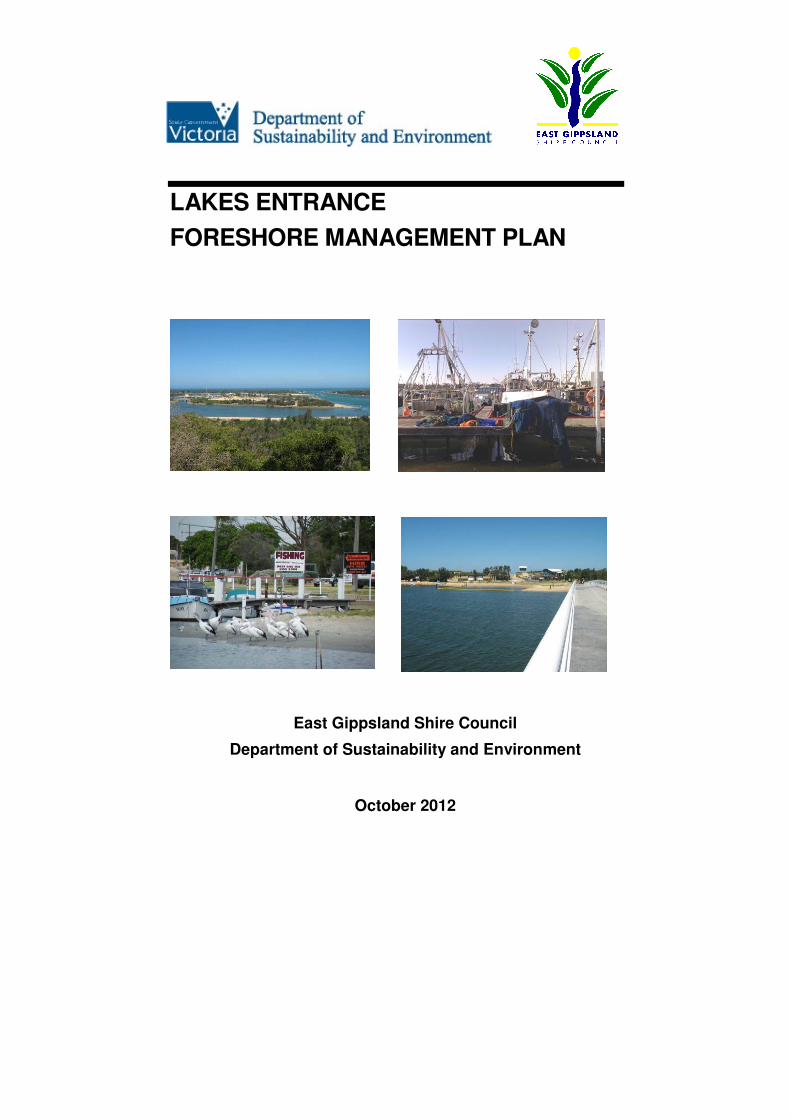
Cover Page Photos:
Top: The entrance, western boat harbour
Bottom: North Arm, Cunninghame Arm bridge
Prepared by:
Kerry Spencer and Eric Sjerp
ETHOS NRM Pty Ltd ENVIRONMENTAL, PLANNING & NATURAL RESOURCE MANAGEMENT CONSULTANTS ABN: 44 104 999 528 PO Box 204, 162 Macleod Street Bairnsdale, Vic. 3875 Telephone: 03-5153 0037 Facsimile: 03-5153 0038 E-mail: [email protected] Website: www.ethosnrm.com.au
Lakes Entrance Foreshore Management Plan Department of Sustainability and Environment and East Gippsland Shire Council
Page 2
Contents
Summary............................................................................................................ 5
1 Introduction .................................................................................................. 7
1.1 Location and study area ................................................................................................ 7
1.2 Objective and scope of management plan.................................................................... 9
1.3 Vision............................................................................................................................. 9
1.4 Implementation and community involvement .............................................................. 10
2 Land status and management responsibility.............................................. 12
2.1 Management responsibility.......................................................................................... 12
2.2 Other relevant authorities ............................................................................................ 13
3 Value of the foreshore................................................................................ 15
3.1 Cultural and heritage value ......................................................................................... 15
3.2 Recreational value....................................................................................................... 16
3.3 Commercial, business and boating value ................................................................... 16
3.4 Natural value ............................................................................................................... 17
4 Relevant strategies, policy and plans ........................................................ 19
4.1 Victorian Coastal Strategy (2008) ............................................................................... 19
4.2 Gippsland Lakes Coastal Action Plan (1999).............................................................. 19
4.3 Gippsland Boating Coastal Action Plan (2002) ........................................................... 19
4.4 Integrated Coastal Planning for Gippsland Coastal Action Plan (2002) ..................... 20
4.5 Victorian Flood Management Strategy (1998) ............................................................ 20
4.6 Gippsland Boating Amenity and Sustainable Infrastructure Study (2008) .................. 20
4.7 Lakes Entrance Foreshore Strategy (Tract 1987)....................................................... 20
4.8 Lakes Entrance Surf Beach Precinct Strategic Works Program (Ethos 2003) ........... 21
4.9 Lakes Entrance Urban Design Framework (2007)...................................................... 21
4.10 North Arm Foreshore & Estuary Action Plan (Vantree & Hanson 1996)..................... 22
4.11 Master Plan and Development Framework for North Arm, Lakes Entrance (2004) ... 22
4.12 Eastern Beach Tourist Park Management Plan (2006)............................................... 23
4.13 Cunninghame Arm Capability Study (1985) ................................................................ 23
5 Activity nodes and precincts ...................................................................... 24
5.1 Natural precincts.......................................................................................................... 26
5.2 Recreation precincts.................................................................................................... 26
5.3 Town precinct .............................................................................................................. 28
6 Management strategies ............................................................................. 30
6.1 Reserve boundaries, committee of management areas and leases........................... 30
6.2 Vehicle access and parking......................................................................................... 32
6.3 Walking, cycle tracks and pedestrian access.............................................................. 35
6.4 Water based recreational activity ................................................................................ 39
6.5 Boating and facilities.................................................................................................... 41
6.6 Facilities and amenities ............................................................................................... 45
6.7 Signage and interpretive information........................................................................... 49
6.8 Flora and fauna management ..................................................................................... 53
6.9 Pest plant and animal management............................................................................ 54
6.10 Fire management ........................................................................................................ 56
6.11 Water quality and flow ................................................................................................. 57
6.12 Flooding and inundation .............................................................................................. 58
6.13 Coastal and tunnel erosion.......................................................................................... 60
6.14 Camping and caravan parks ....................................................................................... 61
6.15 Cultural heritage values and native title ...................................................................... 63
6.16 Property boundaries .................................................................................................... 65
6.17 Public safety and emergency access.......................................................................... 66

Lakes Entrance Foreshore Management Plan Department of Sustainability and Environment and East Gippsland Shire Council
Page 3
7 Conclusion ................................................................................................. 68
Appendix 1 Threatened flora and fauna Lists .............................................. 69
Appendix 2 Development concept figures ................................................... 75
References and relevant strategies.................................................................. 81
Figures
Figure 1 Location map showing study area ................................................................. 8
Figure 2 Management responsibility ...........................................................................14
Figure 3 Precinct and activity node diagram ...............................................................24
Figure 4 Precincts and activity nodes .........................................................................25
Figure 5 Development concepts .................................................................................75
Figure 6 Development concepts .................................................................................76
Figure 7 Development concepts .................................................................................77
Figure 8 Development concepts .................................................................................78
Figure 9 Development concepts .................................................................................79
Figure 10 Development concepts .................................................................................80
Ethos NRM Pty Ltd
Document Control
Client Department of Sustainability & Environment and East Gippsland Shire Council
Title Lakes Entrance Foreshore Management Plan
Author Kerry Spencer & Eric Sjerp
Manager Eric Sjerp
Version Final v1.2
Electronic File Name
8048 le_fshore_mgt plan_final v1.2 september_2011.docx
Date Last Saved 25/5/11
Date Last Printed
13-01-2011 No. Format Date
Distribution: Rod Croft – DSE 1 Draft v1 PDF
3/9/10
Lakes Entrance Foreshore Management Plan Department of Sustainability and Environment and East Gippsland Shire Council
Page 4
Rod Croft – DSE, PCG & STC 1 Draftv1.2 PDF
6/9/10
Rod Croft – DSE, PCG & STC 1 Draft v2 PDF
16/11/10
Rod Croft, DSE 1 Vers 3.1 PDF
08/12/10
Rod Croft, DSE 1 Vers 4 PDF
13/01/11
Rod Croft, DSE : Final Mgt Plan 1 Vers 1.1 PDF
June 2011
Rod Croft, DSE : Final Mgt Plan 1 Vers 1.2 PDF
Sept2011

Lakes Entrance Foreshore Management Plan Department of Sustainability and Environment and East Gippsland Shire Council
Page 5
Summary
Lakes Entrance is a scenic coastal town which is both a popular holiday destination and an important port for commercial boating. Foreshore areas of Cunninghame Arm and North Arm surround much of Lakes Entrance and form an integral part of the township. Visitors and residents have opportunities to undertake a broad range of recreational and water based activities within and around the foreshore.
This Lakes Entrance Foreshore Management Plan has been prepared to improve future use, management and development of the foreshore, as well as to protect natural, cultural and historical foreshore values.
The management plan covers a large area that includes The Esplanade foreshore, Cunninghame Arm from the Flagstaff area at the ‘entrance’ to Lake Bunga, North Arm, Jemmys Point and Bullock Island (Figure 1). Three foreshore precincts have been identified based on linear stretches of land and water with broadly common characteristics. These have been designated ‘recreational precinct’, ‘natural precinct’ and ‘town precinct’ (Figure 3a). Within each of these precincts, activity nodes define activity spots and development sites “within existing coastal settlements which provide a focus area for access to the coast, services, and social interaction within coastal settlements and coastal urban areas, and link and integrate the public and private realms within this area.” (VCS 2008)
Management strategies and recommendations are provided for the issues currently influencing management of the Lakes Entrance foreshore.
In summary the plan recommends:
• rationalising and consolidating management responsibility for foreshore areas
• consolidating and improving vehicle access and foreshore parking
• improving existing pathway networks to provide connected access within and around the study area for pedestrians and cyclists
• promoting and supporting water based recreational activities at appropriate activity nodes
• upgrading boating facilities, particularly along Cunninghame Arm and on Bullock Island
• upgrading facilities and public amenities throughout the entire foreshore to establish a consistent aesthetic theme that complements the town’s coastal setting and boating focus
• preparing a master plan for Bullock Island and a revised master plan for North Arm, to direct future development and provide detailed design and implementation plans
• upgrading signage to convey safety messages, direct people to destination points and providing educational material about the area
• protecting flora and fauna values throughout the foreshore
• implementing an integrated pest plant and animals control program
• minimising fire risk by enforcing regulations and appropriately managing foreshore vegetation
• improving the quality of water being discharged from adjoining residential, commercial and industrial areas into the lakes
Lakes Entrance Foreshore Management Plan Department of Sustainability and Environment and East Gippsland Shire Council
Page 6
• acknowledging that flooding and projected sea level rise needs to be accounted for in the design, development and use of foreshore infrastructure, whilst recognising that foreshore facilities and structures can often sustain short-term inundation, have a shorter design life and can be modified over time as sea levels rise
• controlling erosion to minimise impacts on public land, infrastructure assets and the natural environment
• continuing to improve formal camping and caravan facilities at designated locations
• protecting cultural and heritage values along the foreshore
• clearly identifying boundaries between Crown frontage and private property
• continual improvement of public safety and emergency access
Actions resulting from this plan
• pathway upgrades – widening of existing pathways to meet shared pathway standard, construction of a new pathway at Club Spit and along North Arm past the recreation reserve to Eastern Creek, and along Cunninghame Arm to Eastern Beach Tourist Park
• Eastern Beach – replacement or refurbishment of the toilet block, sealing and formalisation of access to the western car park
• Lake Bunga – upgraded car park, walking tracks and toilet facilities
• Club Spit – a walking track around the water’s edge and interpretative signage
• Main Beach – provision of additional shade, decking around the surf lifesaving clubhouse, day visitor facilities and a small playground
• Bullock Island – improved recreational public open space, possibly including improved parking and access, fishing platforms, public toilet, picnic facilities, shade shelters, playground and sporting equipment, water park or swimming site, a kiosk and landscaping
• Flagstaff Jetty and New Works area – improved pedestrian access within and around the site enabling interpretation of historical significance and safe observation of Gippsland Ports sand management activity
• North Arm Recreation Reserve – improvement of the site for access and use by the general public, including improved pedestrian access, car parking, public toilets and a designated swimming beach
• Jemmys Point–Mt Barkley – preparation of a concept plan to improve visitor facilities and to direct future development of the site as a tourist destination
• boat harbours on The Esplanade – further expansion and planned upgrades to both commercial and recreational boating berths
• Post Office Jetty – together with the recently completed Cunninghame Quay, Post Office Jetty will remain an important foreshore destination for tourists
• the old slipway site– redevelopment of this site as a major tourist attraction including fish sales, cafe, restaurant, toilets and a jetty with itinerant berths for visiting boats
• foreshore area east of Cunninghame Arm Foot Bridge – designated site for approved community events and provision of additional shade and seating facilities.

Lakes Entrance Foreshore Management Plan Department of Sustainability and Environment and East Gippsland Shire Council
Page 7
1 Introduction
1.1 Location and study area
Foreshore areas of Cunninghame Arm and North Arm surround much of Lakes Entrance and are an integral part of this coastal township. Much of the attraction of Lakes Entrance lies not only in the scenic appeal of picturesque views over waterways and Bass Strait, but also in the ability to freely use foreshore areas for recreation and to watch boating activities at close hand.
The foreshore plays a crucial role in commercial fishing and boating activities, with numerous jetties, marinas and boat harbours serving fishing vessels, charter boats and private boats. Several boat ramps allow launching of smaller recreational boats. Bullock Island and The Esplanade are important hubs of fishing and commercial boating activity.
There is a very strong relationship between the commercial areas of Lakes Entrance and the foreshore. Many businesses benefit from their exposure to tourist traffic, both vehicular and pedestrian, along the foreshore.
The study area of the Lakes Entrance Foreshore Management Plan (illustrated in Figure 1) encompasses the public shoreline and adjoining coastal Crown land of:
• North Arm – from Kalimna, along the northern shore to near the end of Albatross Rd; and from the Wyanga Park Winery jetty along the eastern and southern shores to Bullock Island
• Bullock Island – excluding existing Gippsland Ports, LEFCOL (Lakes Entrance Fishermen’s Co-operative) and TAFE facilities
• Cunninghame Arm – from Bullock Island along the northern shore to the golf club, and along the southern shore to the entrance (Long Island)
• Lake Bunga – coastal foreshore reserve area
• shoreline walking track from Lakes Entrance Bridge to Kalimna Jetty, excluding adjoining public land at Kalimna.
Private land is not included in the foreshore management plan except to the extent that it is considered in developing recommendations, due to the strong interdependency between the foreshore and nearby private land use. This relationship underpins the need for integrated planning and management of both the foreshore and private land at Lakes Entrance.
Lakes Entrance entices an increasing tourist market through its ‘fishing village appearance’ and natural beauty of the Gippsland Lakes. The foreshore management plan will seek to balance competing demands by ensuring important natural values are maintained whilst facilitating appropriate use and development of the foreshore.
This plan builds on a previously prepared management plan for the Lakes Entrance foreshore in 1997 (Tract 1997).

Lakes Entrance Foreshore Management Plan Department of Sustainability and Environment and East Gippsland Shire Council
Page 8
Figure 1 Location map showing study area
Lakes Entrance Foreshore Management Plan Department of Sustainability and Environment and East Gippsland Shire Council
Page 9
1.2 Objective and scope of management plan
The Lakes Entrance Foreshore Management Plan will provide clear and agreed directions for management of the Lakes Entrance foreshore and adjoining waterways. The overarching management objective is to maintain important environmental and cultural values whilst realising the potential for boating activities, recreational pursuits and tourism opportunities.
The Lakes Entrance Foreshore Management Plan:
• reviews all existing planning documents and proposals relevant to the Lakes Entrance foreshore
• clarifies boundaries for on-ground management responsibility
• identifies the current condition, values and management issues surrounding the foreshore
• identifies management strategies to protect and improve the foreshore values
• establishes an agreed position with all management agencies on the future use and development of the foreshore and adjoining waterways
• provides a detailed implementation program.
The final management plan has been adopted by all relevant management agencies as the principal tool for guiding future management of the foreshore. After a period of five years the management plan will be reviewed.
1.3 Vision
Lakes Entrance over the next 15 years will continue to grow in its appeal as a holiday and boating destination, providing visitors and residents with opportunities to undertake a broad range of recreational and water based activities. First class boat launching, mooring and access facilities will exist to support the area’s importance as a state marine precinct (BASIS 2008) and to meet increasing demand for use by commercial and recreational boat operators.
The Esplanade, the ‘promenade’ of Lakes Entrance, and its aesthetic values will be improved by the adoption of a consistent coastal development theme for all facilities and amenities, in keeping with the town’s character. The commercial centre, Esplanade and foreshore will be strongly connected, better integrated and developed in accordance with the overall character of the township. Safer and more convenient pedestrian movement will be provided by pathway links and road crossings between the foreshore and business and urban areas.
Improvements to facilities, access and appearance of the foreshore will increase tourism and visitor enjoyment of the area. An extensive foreshore network of pathways will connect activity nodes within the town.
Policies and practices will be in place to respond to the potential effects of climate change and increased inundation.
Existing foreshore vegetation will be protected and managed to improve and conserve its biodiversity and aesthetic value. The natural, cultural and historical value of Lake Entrance will be preserved and become important assets that provide opportunities for education and recreation based activities.
East Gippsland Shire Council and the Department of Sustainability and Environment will work closely with relevant committees of management and community interest groups to actively manage the Lakes Entrance foreshore.
Lakes Entrance Foreshore Management Plan Department of Sustainability and Environment and East Gippsland Shire Council
Page 10
1.4 Implementation and community involvement
This management plan for Lakes Entrance foreshore has been prepared with input from government agencies, community groups, private businesses and the public. Community and stakeholder engagement has been undertaken through the release firstly of a discussion paper in February 2010 followed by a proposed management plan in January 2011.
The discussion paper defined the study area and identified a number of management issues relating to the foreshore. The discussion paper was released for community feedback and additional comments sought through separate focus group meetings and a public meeting which 44 people attended. Another public meeting, attended by 24 people, was held following release of the proposed management plan.
Thirty-five written submissions were received by the Department of Sustainability and Environment on the discussion paper and twenty-six on the proposed management plan. All comments received were considered in preparation of this final management plan.
Comments received from the community on the discussion paper and proposed management plan included:
• strong support for providing a designated swimming only beach within either Cunninghame Arm or North Arm
• the need to provide all mobility access at activity sites and facilities
• the need for improved pathway surfaces, width, signage and connections between popular locations
• support for additional playground equipment near the Cunninghame Arm bridge
• the need to develop a consistent aesthetic theme for facilities and amenities within the urban precinct of the town
• strong support for increasing the number of jetties and marina berths around Lakes Entrance and for providing adequate onshore facilities to service boating (e.g. boat refuelling).
• the need to remove the North Arm Recreational Reserve caravan park and development of that space and the area behind the bowls club for general public recreational use
• a need to provide more shaded seating, seats and bins along Cunninghame and North arms.
• the need for improved parking – a lack of parking facilities, poor configuration, design of car parks and provision for trailer parking.
• the need to protect natural values, particularly shoreline vegetation and habitat.
Management strategies outlined within this document have been prioritised using the following terms:
High Begin immediately
Medium Begin within 2 to 5 years
Low Begin within 5 to 10 years
Ongoing Continual implementation

Lakes Entrance Foreshore Management Plan Department of Sustainability and Environment and East Gippsland Shire Council
Page 11
A business plan encompassing environmental, planning, financial, operating and management parameters, project staging and timing has been prepared as part of the final documentation. This will assist in budget planning and also serve as valuable input and justification for external funding applications.
A master plan for Bullock Island and a revised master plan for North Arm will be prepared to further define the conceptual layout and development of these sites, following the endorsement of this management plan.
The Lakes Entrance Foreshore Management Plan will be reviewed after five years.

Lakes Entrance Foreshore Management Plan Department of Sustainability and Environment and East Gippsland Shire Council
Page 12
2 Land status and management responsibility
2.1 Management responsibility
All foreshore areas within the study area are Crown land reserved under the Crown Land (Reserves) Act 1978 for which the Department of Sustainability and Environment is the ‘underlying Crown land manager’. Day-to-day management of all parts of the foreshore are delegated to various organisations which are appointmented as ‘committees of management’ under the Crown Land (Reserves) Act 1978, except the western portion of Bullock Island, which is managed directly by the Department of Sustainability and Environment. Refer to Figure 2.
The following organisations as committees of management have responsibility for the foreshore:
East Gippsland Shire Council – manages the majority of the foreshore where another committee of management has not been appointed. Council manages much of the foreshore infrastructure including boat ramps, car parks, playgrounds, parks and picnic facilities, and also leases management of areas such as Eastern Beach Tourist Park and the pony club. This is consistent throughout the municipality, where council manages foreshores along the ‘urban interface’ with adjoining waterbodies.
Gippsland Ports – manages land and jetties on the eastern side of Bullock Island including the existing depot and boat yard, a newly appointed area within the centre of the Island and the new Bullock Island landing adjoining SEAMEC (part of Advance TAFE).
Gippsland Ports also manages:
• the boat harbours along the Esplanade
• the old slipway site and jetties
• Bank Jetty, Post Office Jetty
• North Arm Jetty
• Eastern Wharf
• Cunninghame Quay
• the Bullock Island landing
• Flagstaff Jetty
• land at Flagstaff Jetty incorporating dredging and sand by-pass infrastructure
• land at the sand by-pass discharge point on Ninety Mile Beach
• land adjoining Eastern Wharf
• land on Kalimna Hill incorporating the navigation aid (beacon).
Lakes Entrance Ocean Rescue Squad – manages their jetty and building adjacent to the old slipway site on Cunninghame Arm.
Lakes Entrance Recreation Reserve Committee of Management – manages the Lakes Entrance Recreation Reserve (including foreshore camping area) on Rowe and Bulmer streets.
Pony Club – uses under licence the reserve opposite the tourist park on the corner of Eastern Beach Road and Merangbaur Street.
The following have lease agreements over Crown land from one of the committees of management listed above.

Lakes Entrance Foreshore Management Plan Department of Sustainability and Environment and East Gippsland Shire Council
Page 13
Lakes Entrance Golf Club – manages (under a Recreation and Amusement licence from DSE) the golf course on Golf Links Road at the eastern end of Cunninghame Arm.
Eastern Beach Tourist Park – manages (under lease from East Gippsland Shire Council) the tourist park on Eastern Beach Road at the eastern end of Cunninghame Arm.
Lakes Entrance Fishermen’s Co-operative (LEFCOL) – manages (under lease from Gippsland Ports), two loading jetties and a fuel jetty at the south-eastern corner of Bullock Island. A lease directly from the Department of Sustainability and Environment (DSE) exists for the portion of land utilised in the south-eastern corner of Bullock Island.
Appointed land managers are responsible within their designated areas for control of weeds and vermin, vegetation management and management of assets and structures, unless alternative arrangements have been documented. DSE licenses all private jetties along the shores of North Arm and Cunninghame Arm. These must be constructed and maintained to Gippsland Ports standards.
2.2 Other relevant authorities
East Gippsland Catchment Management Authority (EGCMA) is a water authority constituted under the Water Act 1989 with delegated waterway management and floodplain management functions. This empowers the authority to undertake works on designated waterways, and to authorise others to undertake works in accordance with its by-law on waterways protection. The EGCMA prioritises works in accordance with state and regional strategies based on available funding.
East Gippsland Water is a regional water authority. They provide domestic and industrial water and manage wastewater (sewage).
Gippsland Ports, as well as being a committee of management, is the designated waterway manager with responsibilities under the Marine Act 1988, Port Management Act 1995, and Crown Land Reserves Act 1978, including:
• wharfs, piers, jetties and marina development, management and operation
• berthing and mooring development, management and operation
• navigation, port operations, regulation and compliance
• waterway management including boating safety, incident management, emergency response, maritime security, marine pollution response, vessel salvage
• dredging and sand management
• slipways, boat lifting and boat repairs.

Lakes Entrance Foreshore Management Plan Department of Sustainability and Environment and East Gippsland Shire Council
Page 14
Figure 2 Management responsibility

Lakes Entrance Foreshore Management Plan Department of Sustainability and Environment and East Gippsland Shire Council
Page 15
3 Value of the foreshore
Foreshores surrounding Lakes Entrance are valuable for a wide variety of reasons. Substantial areas are highly developed, comprising built infrastructure, sea walls, jetties, recreation facilities and car parks. There are also large areas where the foreshore is less developed and offers passive open space. A number of these relatively undeveloped areas have significant natural and ecological value.
Importantly, the foreshore has a very strong historic and social significance for the many people who either live in or visit Lakes Entrance. Much of the attraction lies not only in the scenic appeal of picturesque views over waterways and Bass Strait, but also in the ability to freely use foreshore areas for recreation and to watch boating activities at close hand. It is these aspects of the foreshore, particularly The Esplanade, that make it an integral part of this regional coastal township, creating the most highly recognisable feature of Lakes Entrance – the ‘signature’ of Lakes Entrance.
3.1 Cultural and heritage value
A number of historic buildings, relics and structures are located within the study area, including the New Works houses on the southern side of Cunninghame Arm. The New Works historical site is located at the western end of Long Island, near the entrance and is listed under the Victorian Heritage Act 1995 due to its scientific and technical significance. The first attempt to construct a safe and permanent entrance into the Gippsland Lakes occurred in 1870, but failed. Additional works (‘new works’) were undertaken on the entrance between 1884 and 1889 which completed the opening. The New Works site includes land on both sides of the entrance, a jetty, remains of a pier, rail tracks, remains of a crane, and various related artefacts (VHD 2010). The site became known as ‘the New Works’ and fishermen began settling in the workers’ houses in the mid 1880s. Post World War 1, Lakes Entrance and the New Works cottages became a popular tourist site. The partially restored Lady Harriet’s Barge, an old steamer which operated on the Lake and Tambo River, is also located at the New Works site. The engineering relics lie spread across the area, most partially buried in sand. These relics are not being actively managed and they are deteriorating and are vulnerable to vandalism (SEM 1998).
Twenty-six Monterey Cypress trees were planted along The Esplanade in 1924 and 1925 in memory of 26 local men who died during World War 1 (LERHS 2010). Although the trees have been removed, the memory of the soldiers has been preserved by a plaque and by the sculptures done by John Brady carved in the tree stumps. These are a well known feature along The Esplanade.
The Gippsland Lakes and surrounding shorelines are known to have sites rich in Aboriginal cultural significance. The Lakes Entrance region was occupied by people of the Gunai/Kurnai language group at the time of European settlement. All Indigenous places and objects, whether registered or not, are protected under the Aboriginal Heritage Act 2006. All Crown land within the study area is subject to a native title determination in favour of the Gunai/Kurnai people. Any future new works, developments or uses (including tenures) on Crown land within the study area must comply with the Native Title Act 1993 provisions, and the relevant procedural rights, if any, must be extended to the appropriate native title parties. The Gippsland Native Title Unit of the DSE coordinates the native title process. Certain types of development or activities in culturally sensitive areas may be required under the Aboriginal Heritage Act 2006 to undertake a cultural heritage assessment and/or cultural heritage management plan.
Lakes Entrance Foreshore Management Plan Department of Sustainability and Environment and East Gippsland Shire Council
Page 16
3.2 Recreational value
Foreshore areas surrounding Lakes Entrance are both a feature of the study area and an important asset as they offer a variety of recreational opportunities popular with both local residents and tourists. Swimming, fishing, boating (motor and yachting), surfing, kayaking, canoeing, paddle boating, jet skiing, water skiing, skate boarding and cycling are all undertaken within the study area.
Lakes Entrance is a state marine precinct (BASIS 2008) for commercial and recreational boat operators. The most popular reason for visiting Gippsland Lakes is recreational boating, yachting and fishing (BASIS 2008). However, there is a shortage of facilities such as fuelling points, jetty berths, itinerant moorings, toilets, rubbish disposal and pump-out points. Appropriate facilities which match the recreational demands are required to ensure cultural and environmental values are protected. Three separate boat ramps enter North Arm off Marine Parade. Both North Arm and Cunninghame Arm have jetties with permanent moorings.
The Esplanade and Marine Parade both have a number of locations that provide access to the lake for water enthusiasts, boat operators and pedestrians. Both roads have long continuous sections of shared pathway along the foreshore in close to the water’s edge for people to use. A number of other less formal walking tracks exist along the foreshore within the study area including at Long Island, Eastern Beach Lake Bunga and Kalimna. Access to the Ninety Mile Beach is possible via a newly built footbridge, opposite Myer St, over Cunninghame Arm to Main Beach, and also further east at Eastern Beach and Lake Bunga.
Main Beach and Eastern Beach provide popular opportunities to swim off the Ninety Mile Beach. However, strong currents and a deep trough can at times make these sites hazardous. Swimming within the lake is not as popular due to an often muddy lake bed and seagrass. Non-motorised recreational water activity also takes place in the study area, especially east of Main Beach where paddle boats, canoes, kayaks and catamarans can be hired.
Fishing is an extremely popular recreational activity throughout the Gippsland Lakes and people fish from jetties, sea walls, boats, the lake foreshore and off the Ninety Mile Beach. Water skiing is a popular activity in North Arm, opposite the recreation reserve. North Arm also has three commercial hire boat operators for people wanting to explore the local area or go fishing.
3.3 Commercial, business and boating value
Lakes Entrance is instantly recognisable by the large number of boats present along the foreshore. Boating is an important activity within Lakes Entrance for commercial, recreational and tourist reasons. The town is home to a large commercial fishing fleet and is an important boating destination for recreational boat users. Access to the Gippsland Lakes and ocean access through the entrance are the main reasons for the commercial success and recreational popularity of boating. Commercial boating operations also service oil and gas industries operating in Bass Strait.
Cunninghame Arm is the primary location for commercial fishing, tourist and recreational boat activity. The boat harbours, Post Office Jetty, Bank Jetty, the old slipway site and Eastern (Scallop) Wharf are where the majority of boats are moored. Short-term and overnight mooring is also available for boats cruising on the Gippsland Lakes. A number of commercial tourist and charter boat operators are located at Post Office Jetty and Cunninghame Arm.
Gippsland Ports’ facilities on Bullock Island cater for port management and vessel maintenance, and are particularly important in servicing the large commercial fishing fleet.

Lakes Entrance Foreshore Management Plan Department of Sustainability and Environment and East Gippsland Shire Council
Page 17
The Bullock Island landing (which is nearing completion), will provide wharf functions and space for net stretching. LEFCOL also operates from Bullock Island.
North Arm is primarily used by smaller boats which can fit under the highway bridge. Three public boat ramps and ten small jetties are located along the southern shore. Jetty berths and boat ramps provide access to boats and waterways by both residents and holiday makers. Three small boat hire operators are located on North Arm. There is a water skiing area in North Arm. Other jetties are found at the Flagstaff area, Kalimna and Wyanga Park Winery.
Throughout Lakes Entrance, there is a strong link between commercial activity, tourism appeal, accommodation, boating activity, pedestrian access to the foreshore and the high visibility of the fishing fleet. However, only two restaurants are actually located on the public waterfront – on jetties along Cunninghame Arm.
Gippsland Ports maintains navigability of the entrance and inner channels with the cutter suction dredge Kalimna and a sand transfer system that pumps sand to a site off the Ninety Mile Beach, approximately one kilometre east of the entrance. Recent dredging has returned the bar to a depth which allows larger vessels to reach the port. Gippsland Ports’ objective is to maintain a navigable channel of approximately 3.5 metres depth. Periodic contract maintenance dredging is also undertaken with a trailer suction hopper dredge. Dredged material is disposed of offshore at approved disposal sites.
3.4 Natural value
Geographically Lakes Entrance is where two bioregions1 meet: the Gippsland Plains and East Gippsland Lowlands bioregions. The Gippsland Plains bioregion is described as flat low lying coastal and alluvial plains with a gently undulating terrain dominated by barrier dunes and floodplains and swampy flats. In contrast, the East Gippsland Lowlands bioregion has gently undulating terraces flanked by coastal plains, dune fields and inlets (DSE 2010a).
Significant areas of remnant indigenous vegetation of state, national and international significance persist within and around the town. Located at the eastern end of the Gippsland Lakes, North Arm and Cunninghame Arm are important estuarine habitats for a broad range of flora and fauna species, including twenty-two threatened or rare flora species, fifty-eight threatened or rare fauna species and nineteen internationally significant migratory birds. Seagrass beds are important nursery habitat for estuarine fish species. Warm temperate rainforest, littoral rainforest, shoreline vegetation, fringing wetlands and the coastal barrier dunes between Cunninghame Arm and Bass Strait are of particular ecological and geomorphological significance.
The foreshore study area is part of the Gippsland Lakes ‘Ramsar wetland of international importance’. The Ramsar convention on wetlands is an international treaty between nations aimed at conserving wetlands. Ramsar wetlands are protected in Australia at a national level by the Environmental Protection and Biodiversity Conservation Act 1999 (EPBC Act).
The Gippsland Lakes is a listed RAMSAR Wetland based on the:
• distinctive regional landscape of wetlands and flat coastal plains of considerable importance for its landforms, vegetation and fauna
• existence of concentrated numbers of Indigenous archaeological sites
1 Bioregions are areas defined by common ecological characteristics and underlying environmental
features.

Lakes Entrance Foreshore Management Plan Department of Sustainability and Environment and East Gippsland Shire Council
Page 18
• outstanding importance for waterbirds, regularly supporting more than 20,000 waterfowl (DEWHA 2009).
A number of different ecological vegetation classes have been mapped within the study area. Four of these are listed as vulnerable within the bioregion; Limestone Box Forest, Damp Sands Herb-rich Woodland, Plains Grassy Forest and Coastal Lagoon Wetland. Warm Temperate Rainforest and Swamp Scrub are also found within the study area and are listed as endangered.
Two floristic communities found within the study area, East Gippsland Alluvial Terraces Warm Temperate Rainforest and East Gippsland Coastal Warm Temperate Rainforest, are listed as threatened communities under the State Flora and Fauna Guarantee Act 1988 (FFG Act). Important patches of Littoral Rainforest, a Critically Endangered EPBC ecological community (a unique group of plants and animals), is also found within the study area. These sites of remnant rainforest are predominantly found within gully systems, marginal bluffs and steep valley sides which are unsuitable for development and provide important habitat for threatened flora and fauna. Large remnant sites of Littoral Rainforest exist on the cliffs below Kalimna, steep foreshore areas adjoining North Arm and Lake Bunga and Long Island. Emergent areas of Littoral Rainforest are also establishing on Club Spit and at Jemmys Point. Erosion, vegetation removal (e.g. clearing for views), recreational activity, rubbish dumping and pest plants and animals are the major threats to these rainforest sites.
A DSE database search within two kilometres of the study area and immediate surrounds recorded 12 threatened and 10 rare flora species including the Viscid Daisy-bush (Beyeria Lasiocarpa), which is listed as vulnerable in Victoria. The search also found 58 threatened fauna species, of which there were 8 EPBC listed species, 25 FFG listed species and 19 migratory species. Threatened fauna included Little Tern (Sternula albifrons), White-bellied Sea Eagle (Haliaeetus leucogaster), Regent Honeyeater (Anthochaera phrygia), Swift Parrot (Lathamus discolor), Long-nosed Potoroo (Potorous poliocephalus), Grey-headed Flying-fox (Pteropus poliocephalus), Fairy Tern (Sternula nereis) and Southern Brown Bandicoot (Isodon obesulus obesulus).
Panoramic coastal and water views are also an important natural value that contribute to the overall appeal of Lakes Entrance. The Gippsland Lakes is an area identified as having ‘significant landscape character’ where it is recognised to be important that the effects of development on the coastal landscape be managed (Planisphere 2006). The Coastal Spaces Landscape Assessment Study (Planisphere 2006) recognises Lakes Entrance and the Ninety Mile Beach to have ‘regional and state significant’ landscape character. The report recommends a reduction of visual impact and intrusion of buildings and structures at the coastal edges, lake edges and prominent ridgelines of large settlements, such as Lakes Entrance.

Lakes Entrance Foreshore Management Plan Department of Sustainability and Environment and East Gippsland Shire Council
Page 19
4 Relevant strategies, policy and plans
Preparation of this foreshore management plan for Lakes Entrance has been in accordance with the requirements of the Coastal Management Act 1995 and guided by a number of policy documents. Reviews of past plans and strategies specific to Lakes Entrance have been undertaken and where appropriate past actions have been included in this plan.
The foreshore management plan has reviewed the appropriateness of all foreshore development, funded by both the private sector and government sectors, in the context of existing planning policies, the type and intensity of development, its location, the retention of ‘coastal open space’, the ‘coastal dependent-ness’ of facilities, and the potential effects on foreshore values.
The following strategies, policies and plans provide both strategic and specific recommendations on the management, development and use of foreshores around Lakes Entrance.
4.1 Victorian Coastal Strategy (2008)
This provides an integrated management framework for the coast and has identified climate change, population growth and marine ecological integrity as significant issues facing coast areas. The strategy describes the Victorian government’s vision for the planning and management of coastal environments, lists government policy commitments, provides a framework for the development and implementation of other related strategies to guide decision making. The strategy states that planning decisions should take climate change, population growth and marine ecological integrity into account, including having a policy of planning for a sea level rise of not less than 0.8 m by 2100.
4.2 Gippsland Lakes Coastal Action Plan (1999)
This details actions to be undertaken by specific organisations and long-term objectives for land managers, including:
• implement actions to minimise sediments from streets and drains with priority for Eastern Creek, Lakes Entrance
• evaluate and implement North Arm Foreshore and Estuary Plan
• implement and enforce local planning controls to preserve valuable vegetation on lake foreshores, especially North Arm and Lake Bunga
• delineate private land boundaries adjacent to Crown foreshore
• provide additional recreational boat access and mooring at town centre
• encourage provision of shower facilities, fuel and short term moorings for visiting recreational boats and yachts
• enforcement of time restrictions for the use of short term moorings.
4.3 Gippsland Boating Coastal Action Plan (2002)
This plan (currently under review) provides a long-term development framework for recreational boating facilities in Gippsland. Recommendations for Lakes Entrance include:
• preparing a revised master plan for North Arm
• rationalising private moorings in North Arm
• reconfiguring the boat harbours in Cunninghame Arm

Lakes Entrance Foreshore Management Plan Department of Sustainability and Environment and East Gippsland Shire Council
Page 20
• providing additional transient berths and facilities (showers, toilets) for itinerant boaters at the western end of Cunninghame Arm
• nominating the western side of Bullock Island as a site which could be developed
• nominating the northern side of Bullock Island as a possible site for a marina.
4.4 Integrated Coastal Planning for Gippsland Coastal Action Plan (2002)
This policy is prepared under the Victorian Coastal Strategy (VCC 2002) and aims to provide an integrated approach to coastal planning in Gippsland. The policy was developed to ‘ensure that coastal development occurs in a sustainable manner, thereby allowing broad community enjoyment of the many opportunities the coast offers while also preserving and protecting its natural features for future generations’ (GCB 2002).
4.5 Victorian Flood Management Strategy (1998)
The purpose of the Victorian Flood Strategy (developed under the Water Act 1989) is to provide effective flood management by identifying objectives, best principles, guidelines and stakeholders. The strategy is implemented at a local level by relevant catchment management authorities, rural water authorities, local government and the DSE. The catchment management authority has declared a 1 in 100 year flood level at Lakes Entrance of 1.8 m (Gippsland Lakes Flood Modelling CEAH 2004).
4.6 Gippsland Boating Amenity and Sustainable Infrastructure Study (2008)
The BASIS study reviewed existing infrastructure and investigated strategic planning for future infrastructure. Strategic priorities which were identified included:
• providing well maintained fuelling and waste pump-out facilities at accessible locations throughout the boating network
• establishing a network of strategically located boating destinations
• promoting the western area of the Gippsland Lakes system as an interesting alternative for boating destinations
• regulating boat berthing time limits and on-water speed limits.
At Lakes Entrance the following upgrade opportunities were identified:
• North Arm – develop pump-out facilities and improve capacity of the public jetty. Rationalise existing jetty facilities for hire boat operators and provide additional permanent berthing.
• Cunninghame Arm – provide more berthing opportunities.
• Drews Jetty – develop into a local destination by upgrading the jetty to accommodate a larger number of boats.
4.7 Lakes Entrance Foreshore Strategy (Tract 1987)
The previous Lakes Entrance Foreshore Strategy divided the foreshore into precincts, with strategies developed for each area. Cunninghame Arm, east of the footbridge, was proposed to become a family recreational space, which is its current primary use, by creating sandy beaches. Eastern Beach was identified as a site for enabling vehicular access to the Ninety Mile Beach and important for its value as a fish breeding and bird

Lakes Entrance Foreshore Management Plan Department of Sustainability and Environment and East Gippsland Shire Council
Page 21
habitat area. The North Arm precinct was recommended as an alternative family beach area. Preservation of Flagstaff Jetty because of its historic significance was considered important and it was recommended that development be limited at this site.
Bullock Island was identified as having potential for future tourist development and greater recreational use. The recently completed Cunninghame Quay development was proposed in this report.
4.8 Lakes Entrance Surf Beach Precinct Strategic Works Program (Ethos 2003)
The Lakes Entrance Surf Beach Precinct Strategic Works Program describes the works program for this precinct, including the surf lifesaving club and patrol tower, paddleboat hire area, toilet and shower block, and public pedestrian paths and open space. The works program identifies a range of actions that need to be achieved to provide better facilities for future needs. Future actions that remain relevant to the study area include:
• complete the surf lifesaving clubhouse and tower
• improve the outdoor picnic area with timber deck
• improve signage
• explore options for replacing the paddleboat hire sheds with a single building of similar architectural design to the surf lifesaving club house.
4.9 Lakes Entrance Urban Design Framework (2007)
The Lakes Entrance Urban Design Framework is one of a series of studies undertaken within East Gippsland Shire to provide strategic guidance for the development of urban areas within the town. The study was based on four general design principles: enhance local character, conserve the environment, promote activity to sustain communities and improve access.
The framework identified the need to provide an appropriate development profile within the town centre and along The Esplanade. Proposed improvements to The Esplanade were: have consistent footpath and kerb treatments, have a landscape treatment with a maritime theme, provide interpretation, protect foreshore views along The Esplanade, strengthen the connection between public open space opposite Myer St and the ocean beach by appropriate signage.
Other strategies for Lakes Entrance as a whole that are relevant to this foreshore management plan included:
• improved pedestrian circulation and safety
• construction of a new ‘gateway’ landscape
• improved car parking arrangements
• improved connection to the Kalimna residential area from the town centre
• construction of pedestrian crossings across the Princes Highway
• provision of ‘all abilities’ access
• redevelopment of Bullock Island to provide recreation and tourist facilities
• promotion of recreational and tourism focused uses within the town.

Lakes Entrance Foreshore Management Plan Department of Sustainability and Environment and East Gippsland Shire Council
Page 22
4.10 North Arm Foreshore & Estuary Action Plan (Vantree & Hanson 1996)
The North Arm Foreshore and Estuary Plan acts as a comprehensive guide for sustainable management of the water and natural environment of North Arm. The emphasis of the plan is to provide amenities and recreational opportunities that are in harmony with the environmental values of North Arm and its catchment. Significant management recommendations derived from this report include:
• improve the management of seagrass, jetties, shoreline and landscape in the section of North Arm in urban areas of Lakes Entrance.
• construct wetlands to reduce nutrients entering the waters of North Arm from the Lakes Entrance urban areas.
• build a walking track system on the foreshore below Seaview Parade and from the Lakes Entrance recreation reserve, north towards the Colquhoun Forest.
• investigate opportunities for commercial uses associated with the recreation reserve section.
• revegetate public land foreshore areas on the west side of North Arm and control weeds in the foreshore generally upstream to the Capes Road area.
• develop planning guidelines for subdivision and development in the catchment areas north of Lakes Entrance.
Strategies of relevance from this plan include:
• cut and remove sea grass in the Marine Parade section, dredge near jetties to deepen the area, and connect future subdivisions to the sewerage scheme
• construct a wetland along Eastern Creek to manage stormwater and absorb nutrients
• improve Marine Parade jetties, use the new beach at the recreation reserve, provide a landing point at Mississippi Creek and continue speed limit restrictions. Focus on passive boating in upper reaches. Retain water ski area until development of a wetland, then review
• construct a walking track along the frontage, act on foreshore privatisation
• commence western shoreline revegetation. Revegetate and control weeds in conjunction with track construction on the eastern side.
4.11 Master Plan and Development Framework for North Arm, Lakes Entrance (2004)
This study investigates and details boating opportunities in North Arm. North Arm is protected from prevailing winds and is described as having excellent boat launching and other facilities. A number of private jetties are in poor condition and all are used to capacity. A large proportion of jetty space is used by private boat hire operators, who also use caravans on the foreshore as booking offices, which are unattractive. The plan acknowledges the potential for North Arm to accommodate further wet berths. However, there are a number of limiting factors including:
• availability for car parking
• water depths
• location of ski zone

Lakes Entrance Foreshore Management Plan Department of Sustainability and Environment and East Gippsland Shire Council
Page 23
• the height of the Princes Highway bridge which restricts entry of large boats.
Two potential marina areas have been identified along North Arm. Consolidation of jetties could result in the hire boat operators moving to either of these sites. Marine Parade east boat ramp is poorly used and silts up. It’s design is poor and there is only limited car parking. The report recommended removing the ramp and using the onshore area for car parking associated with improved nearby beaches. A kiosk or restaurant could be included in any marina design.
4.12 Eastern Beach Tourist Park Management Plan (2006)
The Eastern Beach Tourist Park Management Plan provides recommendations for improving amenities, aesthetics and the financial performance of the park. Substantial recent works have been undertaken in accordance with this plan including refurbishment of toilet and shower blocks, construction of a perimeter fence, construction of new caravans and cabins, provision of ‘RV friendly’ sites, and improved entry and access through the park.
4.13 Cunninghame Arm Capability Study (1985)
The Cunninghame Arm Capability Study was undertaken over 20 years ago at a time when Lakes Entrance was becoming an increasingly popular holiday destination. The study reports on the capability of Cunninghame Arm to support increased levels of recreational use. A large number of recommendations were made including:
• deepen the arm to 4 metres to reduce growth of seaweeds and seagrasses, improve circulation and water quality
• create a swimming beach on the northern side of the arm, east of the footbridge
• upgrade the track to the arm from the footbridge.

Lakes Entrance Foreshore Management Plan Department of Sustainability and Environment and East Gippsland Shire Council
Page 24
5 Activity nodes and precincts
Existing recreational activity and associated infrastructure within the study area is spread largely along the Ninety Mile Beach, North Arm and Cunninghame Arm where the foreshore adjoins residential and retail areas. For the purposes of this plan three discrete precinct types have been identified within the study area: natural, recreational and town precincts. Precincts are linear stretches of land and water broadly grouped by common characteristics. Within each precinct, existing and potential activity nodes have been identified. These are places where activity is high, or likely to be high, and so are proposed for development.
The way activity nodes have been identified is largely consistent with the principles expressed in the Victorian Coastal Strategy (VCC 2008) which describes activity nodes as specific sites of high density recreational use. Identification, management and development of activity nodes can prevent ad-hoc development of recreational facilities, maximise public open space and reduce conflict between different user groups. Figure 3 below provides a schematic diagram of the precinct and activity node concept. Refer to Figure 4 for precincts and activity nodes which have been identified within the study area.
Figure 3 Precinct and activity node diagram
Land
Water
Natural precinct Town precinct
Node Node Node Node Node Node

Lakes Entrance Foreshore Management Plan Department of Sustainability and Environment and East Gippsland Shire Council
Page 25
Figure 4 Precincts and activity nodes

Lakes Entrance Foreshore Management Plan Department of Sustainability and Environment and East Gippsland Shire Council
Page 26
5.1 Natural precincts
Natural precincts are characterised by high conservation value (environmental, aesthetic or cultural), a largely natural environment, passive recreational activity and development restricted to activity nodes or access points.
Low-key development at key activity nodes is permissible provided environmental impacts are minimal and the development is sensitive to the surrounding natural values.
Four natural precincts have been identified within the study area (refer to Figure 4). These are:
• the foreshore abutting the Ninety Mile Beach and Cunninghame Arm from Lake Bunga to the Flagstaff area
• Club Spit
• the North Arm foreshore adjoining Kalimna from Jemmys Point to the wetland just north of Albatross Road
• the North Arm foreshore from Eastern Creek to Wyanga Park Winery.
The activity nodes designated within the natural precincts are: Eastern Beach, Lake Bunga and Club Spit.
• Eastern Beach – located on the Ninety Mile Beach at the eastern end of Cunninghame Arm, it is accessible via Eastern Beach Road and is a popular site for beach activities such as swimming, fishing and surfing. There are access tracks to the beach and two car parks. This is the second most popular beach site in Lakes Entrance and there is scope to upgrade and improve facilities, including replacement or refurbishment of the toilet block, and sealing of the access to the west car park.
• Lake Bunga – is located at the most eastern end of the study area, accessible via Lake Bunga Beach Road. This is a minimally developed site with minimal facilities, significant remnant native vegetation and an estuarine lake. Lake Bunga will remain a low-key recreational activity node, providing opportunities for passive recreation, such as walking, beach going and fishing, while preserving the surrounding natural habitat and minimising adverse effects. Upgrades to the car park, walking tracks and toilet facilities are required.
• Club Spit – is located to the western end of The Esplanade. This landform was created by the deposition of sand following dredging activity at the entrance. The site is a popular location for swimming and has significant native vegetation and aesthetic value. Future development of the site will include a walking track around the water’s edge and interpretative signage which highlights significant aspects of the area. Preservation of high value vegetation and the aesthetic value of this spit are important.
5.2 Recreation precincts
Recreation precincts are characterised by large areas of public open space which provide opportunities to undertake a diversity of recreational activity such as walking, cycling, swimming, fishing and boating. Development is both linear (e.g. pathways) and scattered within the precinct, encouraging people to explore between different nodes.
Lakes Entrance Foreshore Management Plan Department of Sustainability and Environment and East Gippsland Shire Council
Page 27
The aim of a recreation precinct is to maximise opportunities for recreational activity while preserving other foreshore values (e.g. natural, cultural or historical).
The following recreation precincts have been identified within the study area and include (refer to Figure 4);
• Main Beach
• Bullock Island
• Flagstaff Jetty and New Works area
• angling club from Apex Park to Eastern Creek
• Myer Street to Eastern Beach
• the pony club
• Jemmys Point–Mt Barkley
• the golf club.
Activity nodes designated within the recreation precincts are:
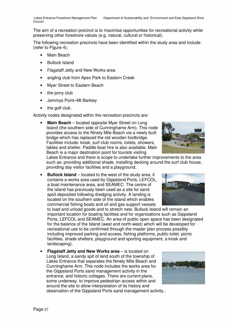
• Main Beach – located opposite Myer Street on Long Island (the southern side of Cunninghame Arm). This node provides access to the Ninety Mile Beach via a newly built bridge which has replaced the old wooden footbridge. Facilities include: kiosk, surf club rooms, toilets, showers, tables and shelter. Paddle boat hire is also available. Main Beach is a major destination point for tourists visiting Lakes Entrance and there is scope to undertake further improvements to the area such as: providing additional shade, installing decking around the surf club house, providing day visitor facilities and a playground.
• Bullock Island – located to the west of the study area, it contains a works area used by Gippsland Ports, LEFCOL, a boat maintenance area, and SEAMEC. The centre of the island has previously been used as a site for sand spoil deposited following dredging activity. A landing is located on the southern side of the island which enables commercial fishing boats and oil and gas support vessels to load and unload goods and to stretch nets. Bullock Island will remain an important location for boating facilities and for organisations such as Gippsland Ports, LEFCOL and SEAMEC. An area of public open space has been designated for the balance of the Island (west and north-west) which will be developed for recreational use to be confirmed through the master plan process possibly including improved parking and access, fishing platforms, public toilet, picnic facilities, shade shelters, playground and sporting equipment, a kiosk and landscaping).
• Flagstaff Jetty and New Works area – is located on Long Island, a sandy spit of land south of the township of Lakes Entrance that separates the Ninety Mile Beach and Cunninghame Arm. This node includes the works area for the Gippsland Ports sand management activity in the entrance, and historic cottages. There are current plans, some underway, to improve pedestrian access within and around the site to allow interpretation of its history and observation of the Gippsland Ports sand management activity..

Lakes Entrance Foreshore Management Plan Department of Sustainability and Environment and East Gippsland Shire Council
Page 28
• Apex Park – a park and picnic area located on the north-east corner of the Princes Highway and Marine Parade adjoining North Arm. A playground, picnic facilities and shelter are available for visitor use. A double boat ramp, car park and toilet facilities are located to the east of the park. Apex Park will continue to provide picnic and park facilities for public use.
• North Arm recreation reserve – located on North Arm bordering Rowe and Bulmer Streets. The reserve provides for a range of recreational uses including a caravan park, football oval and tennis courts. Future use of this area should see removal of the caravan park and development of the site for greater public use. This may include car parking, improved pedestrian access, public toilets and a designated swimming beach.
• Angling club – located to the western side of the Princes Highway on North Arm. This location has angling club rooms, public toilets, boat ramp, sewage hopper, car and boat trailer parking, waste disposal point for recreational vehicles, skate park, picnic tables. It is a popular place for swimming and fishing. This node will remain as a major boat launching, parking and recreation area.
• Eastern Beach Tourist Park – located at the far eastern end of Cunninghame Arm, it is accessible via Eastern Beach Road. The recently upgraded park has sites for tents, caravans, recreational vehicles and cabins. This node will continue to serve as a holiday camping area close to the ocean beach.
• Jemmys Point–Mt Barkley – is the lookout area accessible via the Princes Highway, which provides spectacular views of the entrance and the Gippsland Lakes towards Metung. Below the lookout is important remnant vegetation which extends down to the North Arm water’s edge and east up North Arm and west towards Kalimna Jetty. TheJemmys Point–Mt Barkley location has the potential to be developed as a major tourist attraction including a lookout, interpretation signage and supporting commercial tourism facilities.
• Golf club – located on Golf Links Road and extending between Eastern Beach and Lake Bunga. The golf club will continue to be a major recreation attraction in Lakes Entrance.
• Pony club – located on a parcel of land on the north-east corner of Eastern Beach Road and Merangbaur Street. There is a large area of remnant vegetation on the leased area while a small cleared area is actively used by the pony club. The pony club land has considerable scope for improvement of recreational facilities and to serve as an overflow area for Eastern Beach Tourist Park.
5.3 Town precinct
The town precinct is limited to one strip along The Esplanade and extends from Club Spit to Myer St (where the Cunninghame Arm footbridge is). This precinct consists largely of a built and landscaped environment with a strong relationship between the land and water.

Lakes Entrance Foreshore Management Plan Department of Sustainability and Environment and East Gippsland Shire Council
Page 29
High intensity use over land and water both of a commercial and recreational nature occur in this precinct. The area has little unmodified natural value and the precinct contains numerous structures, buildings and facilities to service the high level of usage.
The aim of the town precinct is to maximise opportunities for boating and tourist activity with high quality facilities and urban foreshore infrastructure.
The activity nodes designated in the town precinct are;
• Boat harbours – this site consists of the eastern, central and western boat harbours located between Carstairs Avenue and Barkes Avenue on the southern side of The Esplanade. Commercial (fishing and charter) and recreational boats are moored in the harbour. Two commercial restaurants are located on the jetties. Boating infrastructure within this node will be upgraded or expanded and will continue to serve both commercial and recreational boating.
• Post Office Jetty – located centrally along The Esplanade, Post Office Jetty is a focal point for tourist charter boat operators. Together with the recently completed Cunninghame Quay, Post Office Jetty will remain an important foreshore destination for tourists.
• Cunninghame Quay – comprises a new concrete jetty for both itinerant and permanent berths, including a limited number of charter operator berths, and a ticket office. It is located opposite Mechanic Street and onshore works include car parking, a boardwalk, landscaping, replacement of the old charter boat ticket office and the addition of showers to the post office toilet block.
• Old slipway site – this node is located opposite Carpenter Street between Cunninghame Quay and the Cunninghame Arm bridge. The slipway is an old industrial site previously used to haul boats onto land for maintenance and repair works. It is situated in a commercial area which has been identified as a site suitable for increased public and tourism use, including seafood sales, cafe, restaurant, toilets and a jetty with itinerant berths for visiting boats. Commercial activity at this site is considered appropriate because of the already highly modified environment within an existing commercial setting. In addition, there will be no loss of public open space through redevelopment of this location.
• Eastern Wharf – is located next to the old slipway site and includes a working wharf and small area on the foreshore used by various commercial fishing boats and oil and gas support vessels to load and unload goods and stretch out nets. Eastern Wharf will continue to serve as an important loading site for fishing and commercial vessels.
• Myer St–Cunninghame Arm Bridge – is located opposite Myer Street where a new bridge has been constructed to allow pedestrian and emergency vehicle access to Main Beach. This node is a major gathering point for a variety of different foreshore users such as beachgoers, shopping patrons and tourists strolling along The Esplanade. Future use of this area will include an approved community event site and provision of additional shade and seating facilities.

Lakes Entrance Foreshore Management Plan Department of Sustainability and Environment and East Gippsland Shire Council
Page 30
6 Management strategies
Management strategies for the Lakes Entrance foreshore study area are described in the following 17 sections (6.1 to 6.17) and have been grouped according to issue type. These sections include detailed descriptions, and the box at the end of each section provides future management recommendations, which include a strategy, aims and actions. The consolidated strategies are illustrated in figures 5 to 10 in Appendix 2.
6.1 Reserve boundaries, committee of management areas and leases
Within the study area, land is managed by several different government agencies, committees of management and private entities. Several areas also have multiple tiers of management. Section 2 of this report provides an overview of current arrangements. As part of the development of this plan a review of the current management relationships was undertaken to ensure that the appropriate agency or group manages an area.
East Gippsland Shire Council is the committee of management for the Eastern Beach Tourist Park and the pony club and lease these sites to the current managers and clubs. Lakes Entrance Recreation Reserve is managed by its own committee of management.
The Department of Sustainability and Environment (Public Land) is currently responsible for the management of the bulk of Bullock Island. A review of use and land management arrangements on Bullock Island resulted in additional land in the centre of the island being allocated to Gippsland Ports for future extension of depot facilities and boatyard operation to accommodate predicted demand over the next 40 years. These land allocations are linked to Gippsland Port’s western yard being decommissioned and the adjacent rock loading wharf being demolished. The balance of Bullock Island will be available for redevelopment as improved recreational public open space. An agency will need to be nominated to manage the associated recreation facilities.
Responsibility for management of the Flagstaff area has been given to Gippsland Ports. This area is where Gippsland Ports’ entrance sand management activity is based and also includes a number of the historical artefacts, but excludes the historic New Works cottages. A separate draft management plan has been prepared for the area (GHD 2009).
Eastern Wharf is used by commercial boats including scallop fishing boats that unload and stretch nets. The wharf and adjacent foreshore is currently managed by Gippsland Ports. Concept plans are in progress to redevelop the nearby old slipway site to create a tourism focused node including associated commercial and tourist opportunities, maritime interpretive information, landscaping or redevelopment and possible reuse of facilities for boat access. Following approval of an agreed redevelopment plan for the old slipway site, a review of the management responsibility may be required.
Lakes Entrance Reserve Committee of Management manages the Lakes Entrance recreational reserve on the corner of Rowe and Bulmer streets, including the North Arm recreation reserve. Camping on the foreshore is limited to people with a permanent site arrangement. This Crown land site has potential to be better used for general public recreational activities. A review of the operation and management of the North Arm recreation reserve is being undertaken as a separate process following this foreshore management plan.
Crown land at Jemmys Point (and Mt Barkley) is currently managed by Gippsland Ports. This is an old arrangement established when Gippsland Ports previously managed the navigational beacon. The beacon is now operated and maintained by Transport Safety Victoria. As Gippsland Ports have no assets at this location, another agency such as the shire council would be better placed to manage this site. The shire already slashes and

Lakes Entrance Foreshore Management Plan Department of Sustainability and Environment and East Gippsland Shire Council
Page 31
maintains the grounds around the public toilet facility, hence a change of management would merely be a formality and in accordance with other foreshore areas managed by the shire that have an urban interface.
Recommended actions – reserve boundaries, committee of management areas and leases
Strategy
Management responsibility for foreshore areas will be rationalised and consolidated to ensure foreshore values are maintained, improved and managed by an agency with the most appropriate resources.
Aims
• to rationalise and consolidate reserve boundaries and management arrangements
• to improve management efficiency of the reserves
• to maintain community involvement in management of the reserves.
Actions
Action Responsibility Priority
6.1a Change management responsibilities within the study area as follows:
Department of Sustainability and Environment, East Gippsland Shire Council, Gippsland Ports
High
• Mt Barkley and Jemmys Point (currently managed by Gippsland Ports) to be managed by East Gippsland Shire Council
• Bullock Island public open space areas to be managed by East Gippsland Shire Council once an agreed development stage is reached
• Management of the old slipway site to transfer to East Gippsland Shire Council, once an agreed development stage is reached.
Medium
6.1b Existing management responsibilities shall remain until reserve boundaries and committee of management areas are finalised and gazetted.
Department of Sustainability and Environment, East Gippsland Shire Council
Ongoing
6.1c Review the operation and management of the North Arm recreation reserve as a separate process to this foreshore management plan.
Department of Sustainability and Environment and East Gippsland Shire Council
High
6.1d Gippsland Ports to continue management of on-water infrastructure at Eastern Wharf and the boat harbours.
Gippsland Ports Ongoing

Lakes Entrance Foreshore Management Plan Department of Sustainability and Environment and East Gippsland Shire Council
Page 32
6.2 Vehicle access and parking
Town precinct
Most visitors to Lakes Entrance will stop at either the lookout or pull-in bays on the Princes Highway at Jemmys Point. These locations provide excellent views of the entrance and the Gippsland Lakes. However, road conditions are unsafe due to poorly located signage and the location of pull-off bays on this section of steep, winding road. Fencing and landscaping at these bays is also old and outdated. Safety and aesthetics are the main reasons behind the need to upgrade these bays.
The Esplanade (Princes Highway) is located along Cunninghame Arm between Club Spit and Short Street and separates the foreshore from the commercial and residential part of the town. Numerous parking facilities and access points to Cunninghame Arm are available via The Esplanade which also serves as the main foreshore promenade. A total of eight off-road car parks exist between Club Spit and Myer Street and two east of Myer Street on the foreshore. Additional parking is also provided in parallel and nose-in locations along The Esplanade.
A traffic management study (Maunsell 2009) identified a number of issues relating to vehicle access and parking along this strip including:
• limited directional signage to off-street car parking facilities (too small or poorly located)
• difficulty in manoeuvring and turning around in foreshore car parks (especially when they are full) and for vehicles towing trailers and caravans
• congestion at Safeway–Target car park
• lack of visibility for vehicles when leaving car parks onto The Esplanade due to cars in parallel parking spots
• separation of cars and pedestrians.
People use parking facilities along Cunninghame Arm for reasons including access to jetties, shopping, sightseeing and parking for workers in nearby shops. Informal car parking occurs east of Myer Street on the foreshore grassed areas, by nearby workers and as informal overflow parking during peak periods.
Recreation precincts
Marine Parade runs parallel to the southern edge of North Arm from the Princes Highway Bridge to the recreation reserve and provides numerous access points to the foreshore. There is a large car parking area for vehicles and boat and trailer parking to the western end of Marine Parade, next to the boat ramp and playground at Apex Park on the foreshore side

Lakes Entrance Foreshore Management Plan Department of Sustainability and Environment and East Gippsland Shire Council
Page 33
of the road. There are a number of informal areas for parking near the finger jetties and boat hire caravans. Parallel parking is also possible along most of Marine Parade. Informal parking occurs along areas of the foreshore and in some places there are no barriers to prevent cars parking at the foreshore edge. This can damage fragile foreshore vegetation which is important for preventing erosion. There is potential to consolidate jetties and swing mooring users who are scattered along North Arm to two designated ‘marina locations’. Car parking could also be formalised and consolidated to designated locations.
Both the North Arm Master Plan (2004) and the BASIS study (2008) recommend consolidation of jetties along North Arm and co-locating the hire boat operators, jetty and swing mooring users on either of the two proposed marina locations.
Access to the lake foreshore becomes restricted further up North Arm, by residential dwellings, steep slopes and foreshore vegetation. No formal car parks are located in this area and access is limited to pedestrian paths (some informal) via nearby roads such as Ferndale Parade, Capes Road, Tara Drive, Blairs Road, and Baades Road (at Wyanga Park Winery).
On the western side of the Princes Highway bridge is a double boat ramp and large car park (with trailer parking). This site is also used by people swimming, skateboarding and fishing, and by members of the angling club which has its club house at this site.
Bullock Island is reached via Bullock Island Road, off the Princes Highway. The road crosses a bridge and leads to the industrial boating areas (LEFCOL, Gippsland Ports and SEAMEC) and then runs across the island to Reeves Channel to a jetty and Gippsland Ports’ current storage and works area. Informal parking and illegal overnight camping occurs on the western part of the island by recreational vehicles. Signage and bollards have recently been installed to address illegal camping. Gippsland Ports have been allocated an additional area within the centre of the island to expand their boat yard and maintenance activities. Modifications and improvements to the current road network and parking arrangements will be undertaken as part of a master plan for Bullock Island.
Natural precincts
Vehicle access into the natural precincts is limited to two sites; Eastern Beach and Lake Bunga. Eastern Beach is the first point east of the entrance where vehicles can park near the beach and is divided into two main areas (east and west). Eastern Beach is a popular site during peak periods and the road at the eastern informal parking area is sealed. The western beach access provides a larger parking area, but it is not sealed and during peak periods the road becomes heavily corrugated due to high use.
Approximately 2.5 kilometres east of Eastern Beach is Lake Bunga which is reached via Lake Bunga Beach Road. The access road and car park are unsealed and parking is poorly designed and signposted.
Recommended actions – vehicle access and parking
Strategy
Foreshore parking at Lakes Entrance will be rationalised and improved to make the use of foreshore land safe and efficient, particularly along The Esplanade and North Arm. Where practical, foreshore parking will be reconfigured and upgraded in preference to providing new parking.
Lakes Entrance Foreshore Management Plan Department of Sustainability and Environment and East Gippsland Shire Council
Page 34
Aims
• to provide safe and efficient vehicle access and parking
• to minimise risks to pedestrians from vehicle movement and traffic
• to maximise efficient use of current parking areas
• to minimise impact on foreshore values from inappropriate vehicle use.
Actions
Action Responsibility Priority
6.2a Seal car park and access road into Lake Bunga. East Gippsland Shire Council
Medium
6.2b Seal access road to second car park at Eastern Beach and formalise car parking areas.
East Gippsland Shire Council
High
6.2c Install bollards with lighting along shared pathway between Myer Street and Short Street.
East Gippsland Shire Council
Medium
6.2d Formalise all road edging to minimise informal parking on foreshore areas with a focus on areas adjoining shared pathways.
East Gippsland Shire Council
Medium
6.2e Formalise space around Youth Recreation Hall on corner of Devitt and Carpenter Streets for car parking and provide directional signage to the site from The Esplanade.
East Gippsland Shire Council
Medium
6.2f Install speed deterrent structures on access road at Eastern Beach.
East Gippsland Shire Council, VicRoads
High
6.2g Install signage directing people to the lookout pull-off bays on Princes Highway when travelling up the hill at Jemmy’s Point.
East Gippsland Shire Council, VicRoads
High
6.2h Review the number of car parks, and the design and safety issues associated with car parking, along The Esplanade.
East Gippsland Shire Council, VicRoads
High
6.2i Remove the car park at Bank Jetty if permanent jetty berth holders are reallocated to the boat harbours and the jetty is modified for transient use (refer to Section 6.5 of the management plan).
East Gippsland Shire Council, Gippsland Ports, VicRoads
Low
6.2j Rationalise and formalise ad-hoc car parking, including creation of bays for boat trailers along North Arm at three locations –west boat ramp (proposed marina site), east boat ramp (proposed marina site) and the recreation reserve.
East Gippsland Shire Council, Department of Sustainability and Environment
Medium
6.2k Reconfigure car parking at the boat harbours to reclaim public open space near the highway, and extend pedestrian pathway over water edge.
East Gippsland Shire Council, Department of Sustainability and Environment, Gippsland Ports, VicRoads
High
6.2l Reconfigure car parking and separate pedestrians from vehicles as part of the old slipway site redevelopment.
East Gippsland Shire Council, Department of Sustainability and Environment, Gippsland Ports, VicRoads
High

Lakes Entrance Foreshore Management Plan Department of Sustainability and Environment and East Gippsland Shire Council
Page 35
Action Responsibility Priority
6.2m Include reconfiguration of car parking and access in the proposed Bullock Island Management Plan..
East Gippsland Shire Council, Department of Sustainability and Environment, Gippsland Ports, VicRoads
High
6.3 Walking, cycle tracks and pedestrian access
Town precinct
Pedestrian access in the town precinct consists of a very popular foreshore ‘promenade’ where visitors enjoy walking along the water’s edge and interacting with boating activity. Activity nodes within this precinct are well connected by a pathway that extends from Club Spit past Cunninghame Arm bridge. A variety of different pathway surfaces have been used including pavers, concrete and jetty boardwalks. As this precinct adjoins the commercial district, pedestrians are frequently crossing the Princes Highway at ad-hoc locations. There is only one formal pedestrian crossing, near Mechanics Street, and one set of traffic lights at Myer Street. During peak holiday periods when there is a steady stream of traffic, safe crossing of the highway to get to the foreshore is difficult. Improved connection between the foreshore and shops will encourage pedestrians to enjoy both sides of The Esplanade with greater ease and safety.
The distance between Cunninghame Arm and North Arm at the narrowest point is only 200 metres. However, visitors do not commonly walk from one foreshore to the other. There is significant potential to improve the connection between the two by identifying and establishing a defined connected pathway. Barkes Avenue is opposite the boat harbours, clock tower and post office in a central location and provides an opportunity to direct pedestrians to North Arm. Barkes Avenue connects to North Arm 150 metres west of the recreation reserve which has potential to be redeveloped to enable greater public use.
The ‘shared pathway’ along The Esplanade extends from Club Spit to just before Short Street in the adjoining recreation precinct. To continue along to Eastern Beach, pedestrians must walk along the sandy water’s edge for 300 metres to opposite Middle Street where the track resumes as a narrow dirt track terminating at Eastern Beach Tourist Park. The pathway is signposted as a ‘shared pathway’, but in places it does not meet the standard width required for this rating. Lack of separation of pedestrians and vehicles along sections of the pathway is also a significant safety issue. Several car parks along the foreshore place vehicles right next to the shared pathway and there are locations where uncertainty exists as to whether vehicles or pedestrians have right of way (e.g. the old slipway site and Eastern Wharf where vehicles can cross the pathway).

Lakes Entrance Foreshore Management Plan Department of Sustainability and Environment and East Gippsland Shire Council
Page 36
Recreation precinct
Pathways are an important feature of the recreation precinct. They provide recreational opportunities for foreshore visitors as well as allowing ease of movement between different activity nodes. From the main beach activity node, a shared concrete pathway extends east along the Cunninghame Arm foreshore, past the little knoll to near Short Street. This is a popular stretch of pathway commonly used by both cyclists and pedestrians; however, conflict between these users often occurs due to high use and a lack of delineated lanes on the path.
A sealed ‘shared pathway’ follows the North Arm foreshore between the Princes Highway Bridge and the recreation reserve. Pedestrian access to the foreshore past this point is limited to informal tracks. There is potential to extend the shared pathway along the foreshore past the recreation reserve and around to Eastern Creek. This would create an important linkage to a planned pathway from the mouth of Eastern Creek to Palmers Road. Extension of a pathway along the foreshore up North Arm past Eastern Creek is difficult due to a number of constraints including private property boundaries, steep land, high value rainforest and foreshore wetland vegetation.
Natural precinct
Walking and cycle access tracks within the natural precinct are important for enabling people to experience and enjoy the natural values of these areas. Many of the existing tracks also provide important linkages between activity nodes.
Access to the Ninety Mile Beach is possible via Cunninghame Arm bridge which brings people to the Main Beach node and surf club. From Main Beach a 4.6 kilometre circuit walking track known as the Entrance Walk heads east to the New Works (Flagstaff) area, and then returns along the beach. The track is in need of maintenance as there are broken steps, steps covered in sand and overhanging vegetation.
At the New Works area a historic walk allows participants to view signposted historic artefacts along predominantly sand tracks. Attractions related to the operation of the entrance include the entrance walls, condition monitoring equipment station mounted above the concrete buttress, the flagstaff and lead lights, the sand shifter infrastructure, the sand transfer station and the former rocket shed. The maze of tracks at this area, all in varying condition, lack directional signage which can create confusion for visitors navigating their way around.
Further east, pedestrian access between Main Beach and Eastern Beach on the southern side of Cunninghame Arm is possible via the beach; there is no formal track through coastal dune vegetation.
Lake Bunga Walking Track extends from the golf club to Lake Bunga car park and is sealed for approximately one kilometre. The track is signposted as a ‘shared pathway’ for use by walkers and cyclists only, but it is narrow and there are sections with poor visibility. A nature trail is also located at Lake Bunga, but is poorly signposted and in need of substantial maintenance works (adjacent picture).
From the Princes Highway bridge, near Bullock Island, there are three pathways – one follows the water’s edge to Kalimna Jetty, another runs beside the highway past a

Lakes Entrance Foreshore Management Plan Department of Sustainability and Environment and East Gippsland Shire Council
Page 37
car pull-in bay up to a lookout near Kalimna Hotel and the third goes steeply uphill via boardwalks through a narrow patch of rainforest to Seaview Parade.
The concrete pathway adjoining the highway has an unattractive old cyclone fence and the path surface is cracked and in need of repair. Cyclists use this section of path, because the road is narrow, but the guardrail is very sharp and close to the path creating a safety hazard. The appearance of this pathway is important as it is highly visible to all passing traffic. The track surface to Kalimna Jetty is generally flat and provides a great opportunity to be close to the lake edge. Once past the sandy point the track becomes blue metal which is a very rough and uneven surface for walkers and cyclists to use.
Club Spit is a largely natural area on the edge of the town precinct. The close proximity of this site to the town makes it an ideal setting for a shared pathway around the water’s edge within a largely natural environment. Views of the Flagstaff area, up and down Cunninghame Arm and boating activity on Bullock Island are possible at different points around the spit.
Along the eastern side of North Arm, Tara Landing is the only formal access point to the foreshore, beyond Eastern Creek. Informal pedestrian access is possible at the end of Ferndale Parade, Bogong Street and Capes Road. From Tara Drive a dirt pedestrian pathway heads down to the small jetty. A site plan detailing land use options was prepared in 2005. It highlights the importance of preserving the foreshore from overuse and degradation. The site plan recommends construction of a deck and boardwalk to the water’s edge to allow launching of canoes and kayaks. However, there are a number of constraints to establishing a linking pathway from Tara Landing to Capes Road, as suggested in the site plan. It cannot be done without having a significant adverse effect on sensitive foreshore vegetation.
Recommended actions – walking track and pedestrian access
Strategy
Existing pathway networks will be upgraded to provide improved and connected access within and around the study area for pedestrians and cyclists. Pathway upgrades will include:
• widening existing pathways to meet shared pathway standard
• construction of a new pathway at Club Spit, along North Arm past the recreation reserve to Eastern Creek and along Cunninghame Arm to Eastern Beach Tourist Park.
Aims
• town precinct – to substantially upgrade pedestrian access to a high standard with hard surfaces and dual use compliant width, to allow for movement of large numbers of people with minimal user conflict
• recreation precinct – to establish a network of pathways and tracks which connect foreshore activity nodes
• natural precinct – to upgrade and maintain existing pedestrian and cycle access along the foreshore without compromising natural and cultural values.

Lakes Entrance Foreshore Management Plan Department of Sustainability and Environment and East Gippsland Shire Council
Page 38
Actions
Action Responsibility Priority
6.3a All new pathways should be constructed to shared pathway standard (dual pedestrian and cycle use)
East Gippsland Shire Council
Ongoing
6.3b Progressively repair and/or upgrade existing paths along The Esplanade and within the urban precinct to a shared pathway standard (width) with consistent surface (concrete) and landscaping treatment, prioritising existing non-compliant sections.
East Gippsland Shire Council
High
6.3c Adopt a consistent lighting theme (bollards with lights as at Cunninghame Quay) for the shared pathways along The Esplanade and North Arm and progressively replace and/or install lights.
East Gippsland Shire Council
High
6.3d Give pedestrians and cyclists right-of-way over vehicles along The Esplanade foreshore shared pathway (using line marking and signage).
East Gippsland Shire Council
High
6.3e Identify Barkes Avenue as a linkage route between Cunninghame Arm and North Arm. Install signage, pedestrian crossings and create a calmed pedestrian environment along Barkes Avenue, including construction of a shared pathway.
East Gippsland Shire Council
Medium
6.3f Upgrade the section of walking track from Princes Highway bridge to Kalimna Jetty along the lake foreshore to a sealed shared pathway.
East Gippsland Shire Council
Medium
6.3g Upgrade (with VicRoads) the section of walking track to remove dangers to pedestrians and cyclists and replace cyclone fencing beside Princes Highway from the highway bridge over North Arm to the lookout near Kalimna Hotel.
East Gippsland Shire Council and VicRoads
High
6.3h VicRoads to identify and install safe crossing points and pedestrian islands (‘havens’) along The Esplanade.
East Gippsland Shire Council and VicRoads
High
6.3i Undertake line marking along the shared pathway east of Cunninghame Arm bridge.
East Gippsland Shire Council
High
6.3j Extend the shared pathway along the foreshore (possibly with a boardwalk) between Middle Street and Eastern Beach Tourist Park.
East Gippsland Shire Council
High
6.3k Extend and widen to 2 metres the shared pathway along North Arm past the recreation reserve and on to Eastern Creek.
East Gippsland Shire Council
Medium
6.3l Do not disturb high value foreshore vegetation by constructing a pathway on the eastern side of North Arm past Eastern Creek.
East Gippsland Shire Council
Ongoing
6.3m Investigate potential to construct a pathway between Eastern Beach and Lake Bunga via Merrangbaur Street and Golf Links Road.
East Gippsland Shire Council
Medium
6.3n Construct a shared pathway with all-ability access, around Club Spit near the water’s edge with interpretative signage.
East Gippsland Shire Council
Low

Lakes Entrance Foreshore Management Plan Department of Sustainability and Environment and East Gippsland Shire Council
Page 39
Action Responsibility Priority
6.3o Upgrade, resurface and widen where required the shared pathway between Lake Bunga and the golf club.
East Gippsland Shire Council
Medium
6.3p Ensure all new shared pathways are designed with consideration for providing access for all abilities.
East Gippsland Shire Council
Ongoing
6.3q Repair steps and structures along the Entrance Walk track.
East Gippsland Shire Council
High
6.3r Assess the feasibility of redesigning the Entrance Walk track to allow all-ability access.
East Gippsland Shire Council and Gippsland Ports
Low
6.3s Construct a deck and boardwalk to the water’s edge which allows launching of canoes and kayaks at Tara Landing.
East Gippsland Shire Council
Low
6.4 Water based recreational activity
Town precinct
Water activities, including swimming, are one of the primary drawcards for visitors to Lakes Entrance. Swimming in the lake occurs at a number of sites within the study area including east of the surf club, opposite Central Hotel, in the channel between Bullock Island and the angling club, Club Spit and opposite the recreation reserve. A trial swimming site was established east of the surf club and footbridge over Cunninghame Arm. The muddy lake bed and the presence of seagrass is a major deterrent for people swimming in the lake. There is strong support for a clean, sheltered family swimming area within Lakes Entrance, with nearby facilities including toilets, shade shelter and tables.
Different sections of the foreshore adjoining The Esplanade are commonly used, particularly during peak summer periods, for boating activities, recreational fishing, swimming and watercraft activities. There are two water ski zones within the study area, one in North Arm near the recreation reserve, east of the small boat ramp and the other on the southern side of Cunninghame Arm, opposite Cunninghame Quay. Both sites provide a calm and sheltered waterway ideal for water skiing. Water skiers and jet skiers both use the water ski zone opposite Cunninghame Quay. Both ski sites are small and narrow and during peak periods there is reported conflict between skiers and other watercraft operators. Boat wake from water skiers and jet skiers also causes problems for moored vessels in Cunninghame Arm. The nearby Barrier Landing is an alternative and popular site for water skiing as there is often less boat traffic. There also is concern from water user groups over a number of safety issues including conflict between swimmers and boat operators within the narrow Cunninghame Arm waterway.
Diving and jumping off jetties and the bridge over Cunninghame Arm is common and poses safety risks. A site in Cunninghame Arm opposite the Central Hotel has become popular for jet skiers and small boat users who land their craft on the small sandy beach.

Lakes Entrance Foreshore Management Plan Department of Sustainability and Environment and East Gippsland Shire Council
Page 40
Recreation precinct
Lakes Entrance and the Gippsland Lakes are extremely popular locations for recreational fishing from boats, jetties, wharfs and the foreshore. The Gippsland Lakes Angling Club is located west of the Princes Highway on North Arm where a boat ramp, sewage hopper and large car park are located. Bullock Island is a popular location for fishing off the sea wall and jetty. Beach fishing is popular at Eastern Beach, Lake Bunga and Main Beach.
The water ski zone in North Arm is located east of the small boat ramp. Boats using these sites can launch in North Arm at the two western boat ramps (either side of the bridge). Skiers launch and moor boats adjoining North Arm recreation reserve on a sandy beach.
East of Cunninghame Arm bridge access for motorised watercraft is limited and this section of waterway is used by people hiring paddle boats, catamarans and windsurfers. Swimming, canoeing and kayaking also occasionally occur along this section of the arm.
Natural precinct
Main Beach and Eastern Beach are popular ocean swimming sites at Lakes Entrance and the Lakes Entrance Surf Club is located at Main Beach. The area at times can have strong currents and a deep trough just off the beach which can make swimming hazardous. Both Main Beach and Eastern Beach are patrolled over summer holiday periods.
Recommended actions – water-based recreational activity
Strategy
Water based recreational activity will be promoted and supported at activity nodes along Lakes Entrance foreshore through appropriate development and provision of facilities which minimise impacts on natural and/or cultural values.
Aims
• to provide appropriate facilities to enable safe use of the foreshore by water based recreational users
• to reduce the potential for conflict between different user groups.
Actions
Action Responsibility Priority
6.4a Designate and maintain a swimming beach on the sandy lake foreshore along North Arm at the recreation reserve. This may require infrequent beach renourishment, with clean sand, from the recreation reserve back towards Laura Street.
East Gippsland Shire Council and Gippsland Ports
Low
6.4b Retain existing swimming beach at Club Spit. East Gippsland Shire Council and Gippsland Ports
Ongoing
6.4c As part of the Bullock Island master plan, investigate the potential to provide a formal swimming area or water park on Bullock Island.
East Gippsland Shire Council and Gippsland Ports
High
6.4d Provide canoe launching facility at Tara Landing. East Gippsland Shire Council and Gippsland Ports
Low

Lakes Entrance Foreshore Management Plan Department of Sustainability and Environment and East Gippsland Shire Council
Page 41
Action Responsibility Priority
6.4e Designate a launch and retrieval access site to the shore on North Arm for water and jet skiers near the recreation reserve, as part of the revised North Arm Master Plan.
Gippsland Ports High
6.4f Review unrestricted speed zones in North Arm in light of potential conflict between the proposed swimming beach and watercraft users, as part of the revised North Arm master plan.
Gippsland Ports High
6.4g Continue to allow fishing by recreational anglers on public jetties, having regard to the jetty purpose, competing uses and safety risks, at designated sites.
East Gippsland Shire Council and Gippsland Ports
Ongoing
6.5 Boating and facilities
Lakes Entrance is a major boating and tourist destination as evidenced by the significant investment in boating infrastructure and designation as a ‘state marine precinct’ (BASIS 2008). Numerous boating and jetty issues have been identified in previous reports and through community consultation, including:
• the need for additional private jetty berths
• the need for additional itinerant berthing
• the need to accommodate larger vessels
• the need to maintain adequate water depths
• the need to review number, location and distribution of swing moorings
• the need for associated public boating facilities, including boat sewage disposal, refuelling, rubbish disposal and onshore toilet and shower facilities.
A number of management and policy documents have previously identified strategic frameworks for boating activities and potential development of additional facilities at Lakes Entrance (refer to Section 4). Findings and recommendations of these reports have been taken into account in determining the best locations for the improvement and location of boating facilities. A common objective from most of the strategies is to concentrate facilities, particularly jetties, into ‘nodes’ in order to prevent ad-hoc development and the proliferation of small structures along foreshores.
Town precinct
Boating for commercial and recreational purposes is the most prominent water based activity within the town precinct. The highest concentration of jetties, including one wharf, is along Cunninghame Arm. There are six main berthing locations along Cunninghame Arm: the boat harbours, Cunninghame Quay, Post Office Jetty, Bank Jetty, Eastern Wharf and Flagstaff Jetty. Berthing of commercial fishing boats, tourist operations and private boats is currently all intermixed across most jetties.
A lack of onshore facilities such as refuelling points, jetties, toilets, rubbish disposal, sewage pump-outs, moorings, temporary berths, and overnight berths are issues for both visiting and local recreational boaters. Identification of suitable sites for these facilities is a priority.

Lakes Entrance Foreshore Management Plan Department of Sustainability and Environment and East Gippsland Shire Council
Page 42
Diesel refuelling facilities are available at LEFCOL on Bullock Island for commercial and recreational boats. For refuelling of recreational boats which require unleaded petrol, the closest location to Lakes Entrance is Metung. A sewage hopper is located at the western boat ramp on North Arm and a sewage pump-out facility is proposed to be located at eastern boat harbour. Gippsland Ports has recently identified a suitable location for boat refuelling and sewage disposal on the northern side of Bullock Island (Nexus 2010).
Recreation precinct
Yachting is popular within the Gippsland Lakes and boat launching and retrieval facilities provided at Lakes Entrance generally cater well to boating enthusiasts. The height of the Princes Highway bridge restricts most yachts from entering North Arm. North Arm has three boat ramps (Apex Park ramp, western ramp and eastern ramp) most of which are generally protected from prevailing winds for boat launching. Apex Park and western boat ramps are large double ramps located either side of the Princes Highway bridge. Eastern boat ramp is a single ramp located to the eastern end of Marine Parade.
East Gippsland Shire Council has recently repaired and upgraded the Apex Park boat ramp. Work included repairing the boat ramp, constructing two floating jetties and upgrading toilet facilities. A large car and trailer parking area is located at this site with informal overflow parking occurring on the grass during peak periods.
Western ramp is located to the west of the Princes Highway and enables large vessels to be launched which would not fit under the Princes Highway bridge if launched at the Apex Park boat ramp. The eastern boat ramp is used infrequently due to problems with siltation, and limited car parking. This ramp is now commonly used to launch small water craft such as jet skis. Shallow water in North Arm restricts boating activity, especially close to shore and restricts the size of boats which can be launched from the eastern boat ramp. The North Arm Master Plan (2004) recommends closing the eastern boat ramp due to its poor design, the limited car parking and siltation. Parking at this site is also an issue as vehicles cross over the shared pathway and park informally, possibly due to a lack of clear delineated bays. The Lakes Entrance Foreshore Management Plan recommends retaining the boat ramp for use by small water craft and boats.
There are nine jetties, of which eight are private, scattered along the foreshore of North Arm and also numerous swing moorings. Three ‘putt-putt’ boat hire businesses with their own jetties operate from this precinct and use foreshore caravans as their ticket offices. There is only limited or no formal parking for hire boat patrons. Both the North Arm Master Plan (2004) and the BASIS study (2008) recommend consolidation of jetties along North Arm and co-locating the hire boat operators, jetty and swing mooring users in either of the two proposed marina locations. A marina in North Arm would be suitable only for smaller boats which can fit under the Princes Highway bridge. It could include a kiosk or restaurant. Additional berths for larger vessels and yachts are still required and the northern side of Bullock Island and near the western boat harbour have been identified as locations where a small marina or jetty could be built. Demand for an on-water refuelling facility could be met by locating one on the northern side of Bullock Island (Nexus 2010).
Informal launching of small water craft (‘tinnies’) occurs along The Esplanade east of Myer Street. Vehicles get to Cunninghame Arm by driving over

Lakes Entrance Foreshore Management Plan Department of Sustainability and Environment and East Gippsland Shire Council
Page 43
the grassed open space and shared pathway onto the sandy lake.
Gippsland Ports has berthing facilities, a boat yard and depot on Bullock Island. LEFCOL also occupy an area of land on the south-eastern side of the island, next to SEAMEC. Gippsland Ports have been informally using an area in the north-west corner of Bullock Island for maintenance and equipment storage. Recent agreements have enabled Gippsland Ports to construct the Bullock Island landing and extension of depot facilities and boatyard operations into the centre of the island to accommodate predicted demand over the next 40 years. These works are linked to Gippsland Ports’ western yard being decommissioned and adjacent rock loading wharf being demolished. The west and north western portions of Bullock Island will be re-developed (subject to a master plan) for improved use as recreational public open space.
Natural precinct
Boating occurs within the natural precinct, but no formal boat launching or retrieval facilities are provided. A public jetty is located at the Flagstaff area and is owned and operated by Gippsland Ports, providing temporary berthing only. Several private finger jetties are scattered along the North Arm natural precinct, including at Tara Landing and Wyanga Park Winery.
Club Spit is a site which has been identified as having potential to accommodate an additional jetty or marina to meet current and future berthing demands at Lakes Entrance. There is only minimal local community support for a marina at this location as the site is highly valued aesthetically, recreationally and because it provides uninterrupted views of the water.
Recommended actions – boating and facilities
Strategy
Boating activity will continue to be strongly supported at Lakes Entrance. Facilities will be improved and upgraded, particularly along Cunninghame Arm and on Bullock Island. Aging jetties along North Arm will be consolidated into new marinas.
Aims
• to identify sites for the development of additional wet berths and associated facilities to meet the increasing demands of boating activity within Lakes Entrance
• to provide facilities that enable safe, easy access and enjoyment for the boating public commensurate with a state boating precinct standard
• to provide boating facilities which are sensitive to the surrounding estuarine and foreshore environments
• to limit development of boating facilities to within defined activity nodes
• to provide all-ability access to all new public jetties
• to provide both short-term and long-term mooring facilities for visiting and local craft.

Lakes Entrance Foreshore Management Plan Department of Sustainability and Environment and East Gippsland Shire Council
Page 44
Actions
Action Responsibility Priority
6.5a Design and construct all new public jetties to consider allowing public recreational fishing use, where appropriate.
Gippsland Ports Ongoing
6.5b Relocate permanent wet berths from Bank Jetty to the redeveloped boat harbours and modify jetty for transient berthing.
Gippsland Ports Low
6.5c Reconfigure and extend the western boat harbour further south into Cunninghame Arm to provide additional berths, including construction of one jetty on the west side of the harbour.
Gippsland Ports Medium
6.5d Clearly define swimming and boating zones within North Arm to reduce the risk of conflict between user groups.
Gippsland Ports High
6.5e Seek approvals for ongoing dredging, in accordance with dredging protocols, to maintain water depths for vessel navigability in boating channels and access to boating infrastructure in North Arm and Cunninghame Arm.
Gippsland Ports Ongoing
6.5f Construct an on-water refuelling and boat sewage disposal jetty facility on the northern side of Bullock Island.
Gippsland Ports High
6.5g Provide transient berths immediately west of Cunninghame Arm footbridge, on the north and south side of the footbridge.
Gippsland Ports Medium
6.5h Restrict expansion of the western boat harbour along the foreshore to only one additional jetty west of the western boat harbour and retain the largely sandy foreshore area east of Club Spit for passive recreational use.
Department of Sustainability and Environment
Ongoing
6.5i Adopt the designated ‘marina nodes’ identified in the North Arm Master Plan (2004) as sites for future consolidation of wet berths, including associated parking, on-water refuelling, boat sewage pump-out or hopper and toilet facility (Refer to figures 5 and 6 in Appendix 2).
East Gippsland Shire Council, Department of Sustainability and Environment, Gippsland Ports
High
6.5j Ensure any new marina constructed provides a sewage pump-out facility.
East Gippsland Shire Council, Department of Sustainability and Environment, Gippsland Ports
Ongoing
6.5k Develop an implementation plan, in conjunction with the North Arm master plan, to consolidate jetties within North Arm and co-locate hire boat operators on two new marinas, near the western and eastern boat ramps.
East Gippsland Shire Council, Department of Sustainability and Environment, Gippsland Ports
Medium
6.5l Provide transient berths on any marina within North Arm.
East Gippsland Shire Council, Department of Sustainability and Environment, Gippsland Ports
Medium

Lakes Entrance Foreshore Management Plan Department of Sustainability and Environment and East Gippsland Shire Council
Page 45
Action Responsibility Priority
6.5m Phase out use of swing moorings (in consultation with users) along North Arm foreshore. This could be done by relocating them, removing them or shifting the boats to a jetty berth on the proposed new marinas.
East Gippsland Shire Council, Department of Sustainability and Environment, Gippsland Ports
Ongoing
6.5n Adopt a policy of no further commercial jetties in North Arm, in accordance with the strategy to focus recreational boating in North Arm and commercial boating in Cunninghame Arm.
East Gippsland Shire Council, Department of Sustainability and Environment, Gippsland Ports
High
6.5o Prohibit construction of non-commercial jetties in Cunninghame Arm between the Flagstaff area and Main Beach footbridge.
East Gippsland Shire Council, Department of Sustainability and Environment, Gippsland Ports
Ongoing
6.6 Facilities and amenities
A wide range of public facilities can be found within the study area including public toilets, playgrounds, picnic shelters, seats, barbeques, rotunda, bins and fish cleaning tables. The East Gippsland Shire Disability Action Plan 2007–09 details actions which should be adopted to improve access for people with a disability. Where new facilities or upgrades to existing facilities are planned, design and construction should address access for people with a disability.
Town precinct
The Esplanade is the most visited location and essentially the ‘promenade’ of Lakes Entrance. Facilities and amenities extend along the entire foreshore and include toilet and shower blocks, rotunda, bins, picnic tables, seats and lighting. The character and standard of facilities within this town precinct is important as they showcase the foreshore and are visually connected. Currently facilities differ markedly in standard and appearance. For example there are six different types of pathway lighting. There is a shortage of seating with shade, bins and barbeques along this precinct given the high number of visitors and locals who use the area.
A rotunda is located just east of the Cunninghame Arm bridge in a large open grass area adjacent to a car park. This site is used regularly for markets and occasionally for special approved events. Further east there are several seats and picnic tables staggered along the grassy foreshore. The rotunda is not heavily used by everyday visitors as it provides limited functionality, primarily due to a lack of seating and to wind exposure.
Recreation precincts
Apex Park on North Arm is the main picnic and barbeque area at Lakes Entrance and is clearly visible as cars drive over the Princes Highway bridge. The park has a number of facilities including shelters, picnic tables, playground and barbeques. Park visitors must use nearby toilets at the double boat ramp. On the western side of the bridge, another toilet block, a skate ramp and picnic tables are also located. Seats are scattered along the

Lakes Entrance Foreshore Management Plan Department of Sustainability and Environment and East Gippsland Shire Council
Page 46
shared pathway strip and a small toilet is located near the eastern boat ramp on North Arm.
Lakes Entrance Golf Club is an eighteen-hole course set amongst remnant native vegetation, located on Golf Links Road between Eastern Beach and Lake Bunga. The golf course is rated 77th in Australia for layout and presentation and also has a function room and club facilities.
The pony club is run by a committee of management and has minimal facilities. No toilets or lighting are present and much of the ground is uneven and poses hazards for riding. An even top-dressed area is desirable and has potential to accommodate riding for the disabled.
Facilities at Jemmys Point–Mt Barkley consist of several picnic tables and two old small toilet blocks. The Lakes Entrance Urban Design Framework (Meindhart 2007) identified this site for major redevelopment including a roundabout at Lookout Road, visitor centre, improved lookout, a pathway to the water’s edge and an elevated pedestrian bridge to Bullock Island. There appears to be little community support for relocating the visitor centre further away from the town centre or for construction of a raised walkway to Bullock Island. Nevertheless, there is potential for both Jemmys Point and Bullock Island to accommodate a tourist or recreational development. Jemmys Point could be improved in the short term by providing interpretation signage, new fencing, new picnic tables, landscaping, upgrading of the lookout and toilet facilities. Community support for redeveloping Bullock Island for greater recreational use is strong, with the opportunity to include a low-key tourist and recreational development. Improved aesthetics, new pathways, fishing facilities, public toilets, water park or swimming site, picnic and shelter facilities were all identified as desirable inclusions for redevelopment of Bullock Island.
Natural precincts
Facilities and amenities within the natural precincts are currently confined to existing activity nodes such as Eastern Beach, Lake Bunga and Main Beach. Construction of new facilities or replacement of existing facilities should be undertaken in a way that does not adversely affect the natural value of the precincts.
Eastern Beach has a playground with shade sail, shelters, picnic tables and barbeques located at the first car park area. This is a very popular alternative to Main Beach during peak periods. The old toilet block is in need of refurbishment or replacement. At the second car park there are several picnic tables, bins and signage. Lake Bunga provides very basic facilities including a toilet block, rubbish bins and a canoe launching site. The toilet block and canoe launching facility are both in need of repair or refurbishment.
Main Beach has a number of substantial facilities including a large new toilet and shower block, one small shade shelter and picnic table, seats, drinking fountains and bins. A kiosk operates out of the bottom of the two storey surf lifesaving clubhouse. Provision of additional shade structures at this site is desirable due to the lack of natural shade and high usage of the area by day visitors. There is community support for locating play equipment at both the northern and southern sides of the bridge.
Picnic tables and toilets are also located above Jemmys Point. This site is not used very often and is unknown to most visitors to Lakes Entrance who alternatively stop on the southern side of the Princes Highway to take pictures and enjoy the view of the Gippsland Lakes and the entrance.

Lakes Entrance Foreshore Management Plan Department of Sustainability and Environment and East Gippsland Shire Council
Page 47
A picnic area with gas barbeque, tables and a composting toilet are located at the Flagstaff area near the public jetty. Bullock Island currently provides no facilities or amenities for public use. There is potential to significantly improve this site in appearance and to provide passive recreational facilities for public use.
Tara Landing is reached via Tara Drive and includes an area of public open space within the gully owned by East Gippsland Shire. A site plan detailing land use options was prepared in 2005 which highlights the importance of preserving the foreshore from overuse and degradation. Provision of a picnic table would improve this location for visitors undertaking passive recreational activity and would minimise adverse effects on the surrounding environment.
Recommended actions – facilities and amenities
Strategy
Facilities and public amenities along the Lakes Entrance Foreshore will be improved and upgraded to establish a consistent aesthetic theme that complements the town’s coastal setting and boating focus. A master plan will be prepared for Bullock Island and the master plan for North Arm will be revised to direct future recreational boating, passive recreation and potential tourist based foreshore commercial activity. The old slipway site and Jemmys Point–Mt Barkley will have concept plans prepared to identify possible uses and provide scope for detailed design of future facilities. Public facilities will also be upgraded at Lake Bunga and Eastern Beach.
Aims
• to provide recreation opportunities and high standard public facilities for passive use and enjoyment of the foreshore
• to ensure new facilities and amenities provide access for people with all abilities
• to prevent pollution from human waste by providing appropriate toilet facilities
• to ensure recreation activities and facilities do not adversely affect the natural and cultural values of the foreshore
• to adopt a consistent style and design of facilities within the foreshore study area.
Actions
Action Responsibility Priority
6.6a Ensure all new facilities or refurbishment of existing facilities provide all-ability access.
East Gippsland Shire Council
Ongoing
6.6b Undertake an aesthetic landscape plan of urban precinct foreshore areas to further define the theme for all new facilities and amenities, including design standards, materials, colours and textures.
East Gippsland Shire Council
High
6.6c Provide shaded seating and tables, of a consistent style and theme, along Cunninghame Arm and North Arm.
East Gippsland Shire Council
Ongoing
6.6d Provide a directional and community events signage board near toilets on Cunninghame Arm at Myer Street.
East Gippsland Shire Council
High
Lakes Entrance Foreshore Management Plan Department of Sustainability and Environment and East Gippsland Shire Council
Page 48
Action Responsibility Priority
6.6e Provide new toilet facilities next to Apex Park in conjunction with upgrading park facilities and play equipment.
East Gippsland Shire Council
Low
6.6f Provide a new toilet block at the old slipway site as part of site redevelopment.
East Gippsland Shire Council and Gippsland Ports
Medium
6.6g Provide a small new toilet block at the ‘knoll’ along Cunninghame Arm, between Myer and Short streets.
East Gippsland Shire Council
High
6.6h Replace or refurbish old toilet block at Eastern Beach.
East Gippsland Shire Council
High
6.6i Replace or refurbish old toilet block at Lake Bunga.
East Gippsland Shire Council
High
6.6j Rehabilitate site of old toilet block near surf club at Main Beach, either for additional public facilities or landscaping and revegetation.
East Gippsland Shire Council
Medium
6.6k Provide additional shade, seating and lighting near the surf club house at Main Beach.
East Gippsland Shire Council
Medium
6.6l Provide two small playgrounds, one near the surf club house and one near the Rotunda.
East Gippsland Shire Council
Medium
6.6m Construct a small bird hide over the water near the second car park at Eastern Beach.
East Gippsland Shire Council
Low
6.6n Provide ‘dog poo stations’ around the foreshore at locations such as Lake Bunga, Eastern Beach, along North Arm and Cunninghame Arm.
East Gippsland Shire Council
High
6.6o Construct timber deck adjoining kiosk at the surf club at Main Beach.
East Gippsland Shire Council
Medium
6.6p Allow the pony club to construct lighting and a toilet and shower block on the pony club land.
East Gippsland Shire Council
Medium
6.6q Allow overflow camping from Eastern Beach Tourist Park during peak periods to use pony club land, subject to further community consultation and negotiation.
East Gippsland Shire Council
Low
6.6r Continue to permit approved community events on public foreshore land in accordance with the provision of the East Gippsland Planning Scheme and relevant council policies, including the Council’s Event Permit process.
East Gippsland Shire Council
Ongoing
6.6s Provide power and tie down points east of rotunda on Cunninghame Arm, to enable construction of a temporary marquee for approved community events.
East Gippsland Shire Council
High
6.6t Extend existing nearby shared concrete pathway to rotunda and improve its useability by providing seating and wind protection.
East Gippsland Shire Council
High
6.6u Limit establishment of public art to suitable foreshore locations within the urban precinct.
East Gippsland Shire Council
Ongoing
6.6v Install picnic table at Tara Landing. East Gippsland Shire Council
Low

Lakes Entrance Foreshore Management Plan Department of Sustainability and Environment and East Gippsland Shire Council
Page 49
Action Responsibility Priority
6.6w Designate Jemmy’s Point–Mt Barkley as a site which could accommodate a tourist or recreational development.
East Gippsland Shire Council, Department of Sustainability and Environment
Ongoing
6.6x Prepare a concept plan for Mt Barkley that includes interpretation signage, new fencing, new picnic tables, landscaping, upgrading of lookout and toilet facilities.
East Gippsland Shire Council, Department of Sustainability and Environment
High
6.6y Prepare a concept plan for the old slipway site in Cunninghame Arm to direct future development and provide detailed concept plans for a tourist attraction that could include maritime interpretive information, seafood sales, cafe and restaurant, toilets, landscaping and a jetty with itinerant berths for visiting boats.
East Gippsland Shire Council, Department of Sustainability and Environment, Gippsland Ports
High
6.6z Prepare a master plan for Bullock Island to direct future development and provide detailed concept plans for improved recreational use, including possible improved parking and access, fishing platforms, public toilet, picnic facilities, shade shelters, playground and sporting equipment, water park or swimming site, a kiosk and landscaping.
East Gippsland Shire Council, Department of Sustainability and Environment, Gippsland Ports
High
6.6aa Prepare a master plan for North Arm to direct future development and provide detailed concept plans for improved recreational use, including consolidation of jetty locations, improved parking, pathway upgrades, provision of a swimming beach, toilet and picnic facilities, shade shelters, playground and sporting equipment and landscaping.
East Gippsland Shire Council, Department of Sustainability and Environment, Gippsland Ports
High
6.7 Signage and interpretive information
Town precinct
Within Lakes Entrance, and along the town precinct in particular, there are many signs including directional, parking, boating, safety, emergency, dog restriction, tourist activity and interpretative or information boards. Directional signage to non-foreshore long-term parking is however limited. Adoption of a consistent theme around the foreshore for particular types of signage would improve aesthetics and make their meaning quickly understandable.
Recreation precincts
Within the recreation precincts, signage is densely grouped at specific activity nodes along the foreshore. In a number of locations signage is prolific and excessive. Consolidation and co-location of some signs is possible and would reduce visual intrusions on the landscape. Signage identifying pathway locations and linkages within

Lakes Entrance Foreshore Management Plan Department of Sustainability and Environment and East Gippsland Shire Council
Page 50
the study area and directional signage to nearby trails such as the East Gippsland Rail Trail are limited.
Natural precincts
There is minimal signage within the natural precincts and what is there is generally confined to activity nodes such as Eastern Beach, Main Beach, the Flagstaff area and Lake Bunga. Safety signage at Eastern Beach, Main Beach and Lake Bunga informs visitors of the hazards of swimming on the Ninety Mile Beach. Directional and interpretative signage at each of these nodes is out-dated, faded and inadequate in a number of locations.
Directional, interpretative and warning signage around the historic walk at the New Works area is of varying type and style. Information boards are old, faded and in some instances out-of-date. Directional signage between Main Beach and the Flagstaff area is lacking and the maze of informal tracks adds to confusion for walkers. Safety and warning signage is important within this area, to ensure the public are informed of hazards and unsafe areas associated with sand transfer and dredging activity. Interpretative signage to highlight artefacts within the New Works site at the Flagstaff area has recently been installed.
Recommended actions – signage and interpretative information
Strategy
Signage will be upgraded at appropriate sites throughout the Lakes Entrance foreshore to convey safety messages, direct people to destination points and educate people about the area. This will increase the enjoyment of the area by visitors.
Aims
• to increase visitors’ enjoyment, appreciation and understanding of the foreshore and Crown reserves
• to provide adequate safety and warning information
• to develop a consistent theme for all signage.

Lakes Entrance Foreshore Management Plan Department of Sustainability and Environment and East Gippsland Shire Council
Page 51
Actions
Action Responsibility Priority
6.7a Co-locate signs wherever possible and adopt common standards to reduce visual impact of excessive signage.
East Gippsland Shire Ongoing
6.7b Install new or updated visitor interpretative and walking track information at the following locations: Main Beach, Eastern Beach, Apex Park, Bullock Island, Club Spit, Cunninghame Arm bridge, Lake Bunga and Jemmys Point. Include the following:
• detailed map of walking tracks, distances, linkages, facilities and vehicle access points;
• biodiversity values of foreshore and surrounding areas, particular reference to wetlands and shoreline vegetation; and
• appropriate information regarding Indigenous customs and use of the foreshore and surrounding areas.
East Gippsland Shire High
6.7c Remove or replace all old, faded or damaged signs.
East Gippsland Shire High
6.7d Modify signage at Eastern Beach to allow dogs off the lead 100 metres away from track entrances to beach, and on the lead within 100 metres of beach entrance tracks. Between 1 November and 30 April allow dogs to move through the area on leads but not to remain within 100 metres of beach entrance tracks.
East Gippsland Shire High
6.7e Install additional signage for parking, including non-foreshore parking within commercial area and boat and trailer parking along The Esplanade.
East Gippsland Shire High
6.7f Install ‘No Parking on Foreshore’ signs along The Esplanade (between Myer Street and Short Street).
East Gippsland Shire Medium
6.7g Install signage directing people to lookout pull-in bays on Princes Highway for cars travelling up the hill at Jemmys Point.
East Gippsland Shire Medium
6.7h Install signage to identify Barkes Avenue as a pedestrian and cycle linkage route between Cunninghame Arm and North Arm.
East Gippsland Shire Medium
6.7i Erect signage indicating water access points for fire trucks.
East Gippsland Shire High
6.7j Erect signage to prohibit all open fires within the foreshore reserve.
East Gippsland Shire High
6.7k Install signage to identify launch and retrieval site on North Arm for water and jet skiers near recreation reserve and swimming area.
Gippsland Ports
East Gippsland Shire
High
Lakes Entrance Foreshore Management Plan Department of Sustainability and Environment and East Gippsland Shire Council
Page 52
Action Responsibility Priority
6.7l In accordance with the Flagstaff Management Plan (GP 2010):
• Install or replace signs at the three entry points to the Flagstaff area (namely at the edge of the picnic area, Flagstaff Jetty; at the committee of management area boundary on the Ninety Mile Beach; and at the boundary of the dune walk) showing the intended flow of pedestrian traffic.
• Install signs to indicate the proposed pedestrian traffic flow within the Flagstaff area allowing visitors to view all points of interest. These signs should be installed at the beginning of all walking tracks and at the track intersections.
• Install hazard warning signs at the following locations: e.g. sand transfer station, sand transfer outlet.
Gippsland Ports High

Lakes Entrance Foreshore Management Plan Department of Sustainability and Environment and East Gippsland Shire Council
Page 53
6.8 Flora and fauna management
Lakes Entrance is home to a diverse range of vegetation types from rainforests to coastal saltmarsh. This diverse habitat in turn sustains large and diverse fauna species, particularly birds. Department of Sustainability and Environment records list 58 threatened fauna species, of which 8 are listed under the EPBC Act, 25 listed under the FFG Act and 19 listed migratory species. Refer to Appendix 1 for a list of threatened flora and fauna species.
There are 12 threatened and 10 rare flora species listed as occurring within a two kilometre radius of the study area. Vegetation communities within Lakes Entrance are regionally, state and nationally significant. Important stands of rainforest including EPBC listed and critically endangered ‘Littoral Rainforest’ is located within the study area. Two types of Warm Temperate Rainforest (Alluvial Terraces and East Gippsland Coastal) listed under the FFG Act are also found within the study area. Foreshores adjoining the Gippsland Lakes are also subject to international obligations for protection of migratory bird species and Ramsar wetland fauna habitat (DSE 2003).
Fringing foreshore vegetation provides important bird breeding and nesting habitat, and is easily damaged by boat wake which can contribute to shoreline erosion.
Vegetation around Lakes Entrance contributes and sometimes impedes panoramic coastal and water views. There are numerous instances where residents are pruning, removing or killing native vegetation in order to preserve water views from their properties. Any vegetation removal requires the appropriate statutory approvals. There is also evidence of non-indigenous vegetation planted on Crown land adjoining the residential areas of Kalimna, North Arm and Cunninghame Arm. Foreshore vegetation, along the Kalimna cliffs is important for stabilising soil and decreasing the potential for erosion, particularly tunnel erosion. Native vegetation also provides important habitat for flora and fauna, especially shoreline bird species.

Lakes Entrance Foreshore Management Plan Department of Sustainability and Environment and East Gippsland Shire Council
Page 54
Recommended actions – flora and fauna management
Strategy
Flora and fauna values throughout Lakes Entrance Foreshore will be protected.
Aims
• to conserve all vegetation within Crown reserves that provide support for biodiversity, recreational and landscape values
• to preserve and improve the foreshore landscape aesthetics
• restrict development within the natural precinct to activity nodes
• ensure foreshore development does not adversely affect high value natural assets.
Actions
Action Responsibility Priority
6.8a Provide educational material to Kalimna, Eastern Beach and Lake Bunga residents regarding illegal vegetation pruning, planting and grass mowing on Crown land.
East Gippsland Shire Council
High
6.8b Remove any dangerous standing and dead fallen trees which pose a safety risk to pedestrians and which are near facilities or buildings within the study area.
East Gippsland Shire Council
High
6.8c Ensure rare and threatened plant species are identified and protected prior to any development activity within the study area.
East Gippsland Shire Council and Department of Sustainability and Environment
Ongoing
6.8d Restrict development within the natural precinct to within identified activity nodes.
East Gippsland Shire Council and Department of Sustainability and Environment
Ongoing
6.9 Pest plant and animal management
Pest plants (weeds) are a threat to the flora and fauna within the study area and have the capacity to transform landscapes. A number of high threat weeds have been identified within the study area including Bridal Creeper, Cape and English Ivy, Periwinkle, Agapanthus, Wandering Trad, Privet, Cotoneaster, Mirror Bush, Dolichos Pea, Panic Veldt-grass, and Rambling Dock. Non-indigenous plantings on Crown land and escaped plants from residential houses have also resulted in notable weed populations adjoining residences within the study area. Wild dogs, foxes, rabbits and hog deer have all been reported as using habitat within the natural or recreational precincts and are a threat to both flora and fauna.

Lakes Entrance Foreshore Management Plan Department of Sustainability and Environment and East Gippsland Shire Council
Page 55
The Catchment and Land Protection Act 1994 is the primary legislation that relates to pest and animal management within Victoria and is relevant to all land (public and private). Weeds which have not been declared noxious are still required to be controlled under other Acts, such as the Flora and Fauna Guarantee Act 1998 and Crown Land (Reserves) Act 1978.
Eradication of new and emerging weeds before they become more widespread is a more effective long-term strategy for weed management and can result in significant cost savings (DSE 2007). Protection of high value assets is the other priority when considering pest plant and animal management. Weed management is most effective if undertaken in an integrated manner by all relevant agencies, irrespective of land tenure.
Recommended actions – pest plant and animal management
Strategy
Control of pest plants and animals within Lakes Entrance will involve on-ground works, cooperation with other agencies and community groups, education and liaison with adjoining private landholders, and enforcement of regulations.
Aims
• to reduce and where possible eliminate pest plant infestations
• to minimise the impact of pest animals on natural values of the Crown reserves
• to consult with adjoining landholders about pest plant management and responsible pet ownership.
Actions
Action Responsibility Priority
6.9a Prioritise weed control actions through the development of an integrated implementation plan.
East Gippsland Shire Council
High
6.9b Implement a program to control high threat weeds.
East Gippsland Shire Council
Medium
6.9c Remove non-indigenous vegetation planted on foreshore where it poses a threat to biodiversity, recreational and landscape values.
East Gippsland Shire Council
Medium
6.9d Provide ‘Grow Me Instead’ and ‘Creeping Backyards’ educational material to Lakes Entrance residents regarding inappropriate foreshore planting and garden escapees.
East Gippsland Shire Council
High
6.9e Encourage Lakes Entrance residents to implement responsible pet ownership practices.
East Gippsland Shire Council
High
6.9f Management agencies should work in cooperation to control all high threat weed populations along the foreshore.
East Gippsland Shire Council, Department of Sustainability and Environment, Gippsland Ports
Ongoing
Lakes Entrance Foreshore Management Plan Department of Sustainability and Environment and East Gippsland Shire Council
Page 56
6.10 Fire management
The East Gippsland Municipal Fire Prevention Plan (EGSC 2009) addresses fire management issues on private land within the study area. Fire management issues on Crown land are addressed by the Department of Sustainability and Environment (DSE) through the Gippsland Fire Protection Plan (DSE 2010b). Lakes Entrance fire brigade is the responsible agency for fires on private land. The nature of the study area, which consists of coastal beaches and lakes, makes emergency vehicle access difficult to some areas. Education about fire behaviour and the way in which fire risk can be reduced is important.
Open fires are prohibited in all Crown land areas within the study area; however, there is evidence of people lighting illegal campfires, especially on beaches. Illegal fires pose a significant threat in these locations due to the highly flammable nature of surrounding coastal vegetation and the potential for fires to spread quickly to nearby residential areas.
Vegetation along the foreshore, especially Banksia trees, are dependent on fire for regeneration. However, fuel reduction burning of a narrow strip of vegetation along the foreshore poses a high level of risk to adjoining private properties should the fire escape. Removal of vegetation to reduce fire risk within a residential setting must be undertaken in accordance with legislation, particularly Clause 52.17 Native Vegetation of the Victorian Planning Provisions. Consultation with East Gippsland Shire must be undertaken to determine whether a permit is required, prior to removal of vegetation from private land. Removal of vegetation from Crown land should also be discussed with the DSE beforehand to ensure that proper regulations are followed.
Grass slashing reduces fire risk and is undertaken along the foreshore strips of Cunninghame Arm and North Arm and other locations within the study area in accordance with East Gippsland Shire’s maintenance regime.
All future fire management activities will need to be consistent with government policy and be based on the recommendations of the 2009 Victorian Bushfires Royal Commission.
Recommended actions – fire management
Strategy
Fire risks within the Lakes Entrance foreshore and risks to adjoining properties will be minimised by enforcement of regulations and appropriate management of foreshore vegetation that is balanced against the need to conserve natural values.
Aims
• manage foreshore areas to minimise fire risk without detrimentally affecting natural values
• protect property and assets from fire risk.
Actions
Action Responsibility Priority
6.10a Maintain all grass areas to reduce fuel loads within the study area.
East Gippsland Shire High

Lakes Entrance Foreshore Management Plan Department of Sustainability and Environment and East Gippsland Shire Council
Page 57
Action Responsibility Priority
6.10b Consult with landholders adjoining Crown land about appropriate fire management strategies around their property.
Country Fire Authority, East Gippsland Shire Council, Department of Sustainability and Environment, Victoria Police
Ongoing
6.10c Only undertake fuel reduction burning of foreshore vegetation with approved plan via DSE and if benefits outweigh environmental risks (erosion, escape).
Country Fire Authority, East Gippsland Shire Council, Department of Sustainability and Environment, Victoria Police
Ongoing
6.10d Continue to prohibit all open fires within the foreshore reserve. Erect signage accordingly.
Country Fire Authority, East Gippsland Shire Council, Department of Sustainability and Environment, Victoria Police
Ongoing
6.10e Ensure fire response strategies (including fuel reduction burning) take into account local characteristics, including potential ignition points, surrounding vegetation densities, water points and access points to the foreshore.
Country Fire Authority, East Gippsland Shire Council, Department of Sustainability and Environment, Victoria Police
Ongoing
6.11 Water quality and flow
The Lakes Entrance foreshore abutts the Gippsland Lakes, which is a series of large estuarine lakes open to the sea via a constructed ‘entrance’ at Lakes Entrance. The Gippsland Lakes are fed by several large rivers which flow through forest, agricultural, industrial, and residential land before entering the lakes. The nature of the adjoining landscape affects the quality and quantity of water entering the Gippsland Lakes.
Stormwater from a number of sites around the town is discharged directly into the Gippsland Lakes without treatment or litter removal. Eleven storm water outlets are located in North Arm and discharge close to the shore, resulting in rubbish accumulating on the beach.
At the time of preparing this foreshore management plan, works are proposed at Eastern Creek to address stormwater runoff, nutrient levels, pollution and flooding by the construction of a nutrient stripping wetland at the mouth of the creek and diversion pipes at Middle Street (which have been installed).
Blue-green algae (cyanobacteria) are a natural component of most aquatic systems. Algal blooms occur within the Gippsland Lakes and study area under certain environmental conditions, triggered by different factors including nutrient levels, low inflow from catchment and warm weather. A significant bloom can be harmful to humans, livestock, animals and birds if they come into direct contact with it. Large blooms reduce the attractiveness of the area to tourists, as water activity is the main drawcard for visitors to Lakes Entrance.
Cunninghame Arm is a narrow, ‘blind’ waterway which is susceptible to pollution and water quality problems. Within the golf club at the far eastern end of Cunninghame Arm there are a series of ‘warm holes’ which provide important fish and bird breeding habitat. A certain amount of water is needed to flush the warm holes and prevent algal blooms.

Lakes Entrance Foreshore Management Plan Department of Sustainability and Environment and East Gippsland Shire Council
Page 58
Construction of the new bridge over Cunninghame Arm at Eastern Beach and channel deepening has increased the amount of water flowing into the warm holes. During high tide events there has been increased flooding of the golf greens which has in turn resulted in the death of vegetation due to saline water inundation. Treated wastewater is used at the golf club to irrigate the greens.
Recommended actions – water quality and flow
Strategy
The effects of poor quality water discharging to waterbodies abutting the Lakes Entrance foreshore will be reduced by improved management practices and compliance with relevant regulations.
Aims
• to protect the quality of waterways around Lakes Entrance
• to protect the health of foreshore vegetation, fauna and users of the waters around Lakes Entrance.
Actions
Action Responsibility Priority
6.11a Install and maintain a boat sewage pump-out facility at Bullock Island.
Gippsland Ports High
6.11b Encourage increased use of on-board holding tanks and portable toilets.
Department of Sustainability and Environment, Gippsland Coastal Board, Gippsland Ports
Ongoing
6.11c Ensure any new marina constructed provides a sewage pump-out facility.
East Gippsland Shire Council, Department of Sustainability and Environment
Ongoing
6.11d Ensure compliance with EPA licence for use of treated wastewater by the golf club to irrigate greens or any other foreshore area.
East Gippsland Shire Council, Environment Protection Authority
Ongoing
6.11e Maintain adequate water flow to Cunninghame Arm ‘warm holes’.
East Gippsland Shire Council, Department of Sustainability and Environment
Ongoing
6.11f Investigate benefits and possible effects of installing a flood gate at the Eastern Beach bridge to reduce inundation of golf course.
East Gippsland Shire Council, Department of Sustainability and Environment
Medium
6.12 Flooding and inundation
Foreshore areas at Lakes Entrance and low lying parts of the township, particularly areas west of Whiters St, are vulnerable to flooding and inundation, as illustrated in the accompanying photos taken by East Gippsland Catchment Management Authority during a significant flood in

Lakes Entrance Foreshore Management Plan Department of Sustainability and Environment and East Gippsland Shire Council
Page 59
June 2007.
Flooding at Lakes Entrance can occur due to high rainfall within the catchment, high ocean king tides or storm surges, which when occurring concurrently result in substantial inundation. Future sea level rise, and the predicted increased frequency and intensity of storms are likely to exacerbate the severity of flood effects.
A ‘Land Subject to Inundation Overlay’ in the East Gippsland Planning Scheme extends over most of the Lakes Entrance commercial area between the highway bridge and Eastern Creek–Whiters Street area. The overlay identifies land which may be affected by a 1 in 100 year flood.
The Victorian Coastal Strategy (2008) and State Planning Policy Framework states as policy (based on the report of the Intergovernmental Panel on Climate Change (IPCC 2007) that planning should be for a sea level rise of not less than 0.8 metres by 2100, and apply the precautionary principle to planning and management decision making.
To better plan for the future of Lakes Entrance and prepare for the anticipated changes, the Victorian Government, East Gippsland Shire Council and the East Gippsland Catchment Management Authority are working to undertake the Gippsland Lakes Inundation Management Project. As an interim measure, an interim use and development control has been applied to the business district of Lakes Entrance, which seeks to achieve a fair balance between landowners’ development expectations and the need to plan for the long-term effects of sea level rise pending the completion and implementation of longer term controls from the Gippsland Lakes Inundation Management Project and final state-wide recommendations from the Coastal Climate Change Advisory Committee and Future Coasts program.
The interim use and development control only applies to residential and business zoned land, and excludes Crown land foreshore areas.
The ‘precautionary principle’ of the Victorian Coastal Strategy (2008) recognises that investment in minor coastal public infrastructure is acceptable provided the design life is within the timeframe of predicted climate change effects. Because the effects of climate change will not take place immediately, investment is still warranted in coastal and foreshore facilities (e.g. jetties, boat ramps and non-habitable buildings) which have a short asset replacement life (approximately 20 to 30 years) and which are generally on public foreshore land. When repaired or replaced, such facilities can often be modified to adapt to changing coastal conditions.
Recommended actions – flooding and inundation
Strategy
Use and development of the Lakes Entrance foreshore will take into account flooding and projected sea level rise in accordance with state policy and interim use and development controls of the East Gippsland Planning Scheme, while recognising that foreshore facilities and structures can often cope with short-term inundation, have a design life that is often shorter than the time in which significant climate effects are expected, and can be modified over time if flooding worsens as sea levels rise.

Lakes Entrance Foreshore Management Plan Department of Sustainability and Environment and East Gippsland Shire Council
Page 60
Aims
• to minimise damage to assets from the effects of flooding
• to provide appropriate foreshore infrastructure and facilities that are not adversely affected by increased flooding
• to implement strategies and actions to mitigate the effects of flooding and inundation.
Actions
Action Responsibility Priority
6.12a Continue to invest, replace and maintain foreshore infrastructure which has a short asset life expectancy and which can be modified to respond to effects of increased flooding.
East Gippsland Shire Council, Department of Sustainability and Environment, East Gippsland Catchment Management Authority, Gippsland Coastal Board, Gippsland Ports
Ongoing
6.12b Design and locate facilities so as to minimise the effects of flooding and to ensure the facilities do not contribute to increased flooding in surrounding areas.
East Gippsland Shire Council, Department of Sustainability and Environment, East Gippsland Catchment Management Authority, Gippsland Coastal Board, Gippsland Ports
Ongoing
6.12c Continue to investigate the causes of and ways of dealing with sea level rise and shoreline erosion at Lakes Entrance.
East Gippsland Shire Council, Department of Sustainability and Environment, East Gippsland Catchment Management Authority, Gippsland Coastal Board, Gippsland Ports
Ongoing
6.12d Continue to work in cooperation through the Gippsland Lakes Inundation Management Project to develop appropriate policy responses for increased flooding and inundation of Lakes Entrance foreshore and township.
East Gippsland Shire Council, Department of Sustainability and Environment, East Gippsland Catchment Management Authority, Gippsland Coastal Board, Gippsland Ports
Ongoing
6.13 Erosion
Erosion around the lake foreshore is caused by a number of factors including increased salinity of the Gippsland Lakes, die-back of saline sensitive foreshore vegetation, boat wake, wind and wave chop. Sections of the foreshore are being eroded, resulting in loss of foreshore vegetation and creating the potential for the undermining of assets such as water and sewer mains.
Sea walls have been constructed around sections of the foreshore to stabilise natural movement of sand and enable the construction of large boat mooring facilities. This is evident primarily along The Esplanade and on Bullock Island where there is almost constant boating activity and a large number of jetties. The sea wall provides a solid foreshore surface. However, repairs to sections of undermined sea wall on Bullock Island and The Esplanade are required.
Tunnel and gully erosion at Kalimna, directly above North
Lakes Entrance Foreshore Management Plan Department of Sustainability and Environment and East Gippsland Shire Council
Page 61
Arm is evident. Protection of remnant vegetation on these steep cliffs is essential as their removal could contribute to further erosion activity. At Jemmys Point there is evidence of gully and tunnel erosion occurring down minor drainage lines which is being exacerbated by the use of trail or mountain bikes.
Recommended actions – erosion
Strategy
Erosion along Lakes Entrance Foreshore will be controlled to minimise its effects on public land, infrastructure assets and natural values.
Aims
• to protect natural, recreational and social values of Lakes Entrance foreshore from detrimental coastal erosion processes
• to protect foreshore vegetation and public facilities from erosion.
Actions
Action Responsibility Priority
6.13a Monitor erosion activity annually. East Gippsland Shire Council, Department of Sustainability and Environment, Gippsland Ports
Ongoing
6.13b Repair damaged sea walls along The Esplanade and on Bullock Island.
East Gippsland Shire Council, Department of Sustainability and Environment, Gippsland Ports
High
6.13c Maintain and repair erosion control structures as required.
East Gippsland Shire Council, Department of Sustainability and Environment, Gippsland Ports
Ongoing
6.13d Remove any old ineffective erosion structures.
East Gippsland Shire Council, Department of Sustainability and Environment, Gippsland Ports
High
6.13e Identify and fence off unstable areas above Jemmys Point and revegetate as required to stabilise soil movement. Prevent access by mountain or trail bikes.
East Gippsland Shire Council, Department of Sustainability and Environment, Gippsland Ports
High
6.14 Camping and caravan parks
Public coastal land makes up 96% of the Victorian coast (VCC 2008). Camping on foreshore areas of Victoria has been occurring for a long time and is an activity highly valued by the community. Camping can offer a safe and affordable holiday experience for families and holiday makers. There are also increasing numbers of retired people, international visitors and holiday makers who are travelling in campervans and caravans. East Gippsland Shire Council has recently installed a waste disposal site, near the angling club, for recreational vehicles (‘RVs’).
Lakes Entrance is a popular destination for all of these groups and the sheer number of caravan parks within the township indicates the high popularity of this type of accommodation. Within the foreshore study area there are two caravan parks; Eastern Beach Tourist Park on Cunninghame Arm and the recreation reserve on North Arm. The management, appearance, operation and occupancy of these parks differ significantly. ‘An important principle for Crown land caravan parks is that access to public land is fair and

Lakes Entrance Foreshore Management Plan Department of Sustainability and Environment and East Gippsland Shire Council
Page 62
equitable and that sites on public land are not managed in an “exclusive” way – rather that sites are available to the broadest range of users’ (DSE 2006 [updated 2012], p. 32). In high demand areas, long-term occupancy of sites is seen as unacceptable. Lakes Entrance is seen as an area with high demand for sites and hence a review of the operation and management of the North Arm recreation reserve is being proposed by the DSE as a separate process to this foreshore management plan. The site has significant potential to be used for greater general public recreational use.
A management plan for Eastern Beach Tourist Park was prepared in 2008. Since then a number of the recommendations have been implemented and a considerable amount of work has been undertaken to upgrade and improve the facilities, campground layout and appearance. The pony club site has been identified as a location where overflow camping could occur during peak periods.
Illegal camping occurs within the study area at a number of locations including Bullock Island, Eastern Beach and Lake Bunga. The increasing number of recreational vehicles on the road in recent years has increased this type of activity. The effects of illegal camping on the environment can include fire, loss of native vegetation, erosion, loss of biodiversity, introduction of pest plants and sewage and waste disposal. The notion of ‘free’ camping on Crown land within towns is also seen as socially unacceptable when other visitors pay to stay and camp within formal caravan parks, which is an important business sector within the community.
The Caravan and Camping Parks on Coastal Crown Land Reference Group Report (DSE 2006 [updated 2012]) investigated a number of the issues of long-term capacity of existing parks on Crown land and the opportunities for new parks. Issues raised include demand for sites and facilities, expectation of facility standards, facility upgrades and maintenance, mix of accommodation, lease terms and security, park management and planning, utilisation of sites throughout the year and environmental impacts. The Victorian Coastal Strategy (2008) has recommended that ‘best practice’ management guidelines be developed for caravan and camping parks on coastal Crown land.
Recommended actions – camping and caravan parks
Strategy
Formal camping and caravan facilities will continue to be supported and improved at designated locations along the Lakes Entrance foreshore, while informal overnight camping will be discouraged.
Aims
• to provide for safe and enjoyable holiday and camping accommodation within Lakes Entrance
• to maintain and improve the appearance and facilities of the Eastern Beach Tourist Park.

Lakes Entrance Foreshore Management Plan Department of Sustainability and Environment and East Gippsland Shire Council
Page 63
Actions
Action Responsibility Priority
6.14a Continue to implement actions from the Eastern Beach Tourist Park Management Plan.
Eastern Beach Tourist Park leaseholder / manager
Ongoing
6.14b Review the appropriateness of using public foreshore land for the operation of a caravan park within the North Arm recreation reserve.
Department of Sustainability and Environment
High
6.14c Should demand justify, following potential removal of permanent caravans at North Arm Recreation Reserve, investigate opportunities and community support for overflow camping (for Eastern Beach Tourist Park) and Lakes Entrance pony club members.
East Gippsland Shire Council, Department of Sustainability and Environment
Low
6.14d Through consultation with appropriate organisations identify a suitable site for overnight recreational vehicle use.
East Gippsland Shire Council High
6.15 Cultural and heritage values and native title
Aboriginal Affairs Victoria records (GCHU 2006) indicate that there are several important sites of Indigenous cultural significance located within the Lakes Entrance foreshore study area. All Indigenous places and objects, whether registered or not, are protected under the Aboriginal Heritage Act 2006.
Any future new works, developments or uses (including tenures) on Crown land must comply with the future act provisions of the Native Title Act 1993, and the relevant procedural rights, if any, must be extended to the appropriate native title parties. The DSE Gippsland Native Title Unit coordinates the native title process.
Changes to current native title processes are possible in the near future due to the settlement of the Gunai/Kurnai native title claim in November 2010, but at this stage no further details are available. Once a new set of processes has been determined, a roll out will occur, possibly replacing the current future act provisions. This could lead to a new set of approval processes. Until such a roll out occurs the existing future act process will continue to apply to any future works proposed on Crown land in the study area.
The New Works area at the Flagstaff area is listed on the Victorian Heritage Register and is also covered by a heritage planning overlay. Of particular value are relics and infrastructure associated with the creation of the Entrance, including the cottages. Remaining relics of value include the rocket shed, crab winch, heavy duty winch tramway, shipwreck bell post, Lady Harriet’s barge, Day’s tractor, steam crane, timber framed trolley, overhead crane, gear carriage and navigation beacons (DHHPM 2007). A number of the relics are corroding and are in locations, covered by sand and/or vegetation overgrowth.

Lakes Entrance Foreshore Management Plan Department of Sustainability and Environment and East Gippsland Shire Council
Page 64
Recommended actions –cultural and heritage values and native title
Strategy
Cultural and heritage values will be protected, and where possible improved, throughout the Lakes Entrance foreshore.
Aims
• to protect all Indigenous and historical sites and places of significance throughout the Crown reserves
• to comply with native title legislation
• to increase public appreciation of Indigenous customs and use of the Crown reserves and surrounding areas
• to increase appreciation of the area’s natural and historic features through interpretative facilities.
Actions
Action Responsibility Priority
6.15a Maintain confidentiality in respect of Indigenous customs, places and objects in accordance with Indigenous tradition and the wishes of relevant Indigenous communities.
All parties, Aboriginal Affairs Victoria
Ongoing
6.15b Protect all Indigenous places, sites and objects from disturbance during any construction and maintenance works, and change of use or tenure prior to construction or maintenance commencing.
All parties, Aboriginal Affairs Victoria
Ongoing
6.15c Encourage research and development of management strategies for Indigenous cultural heritage values of the foreshore, Crown reserves and surrounding area, in collaboration with the relevant Indigenous communities.
All parties, Aboriginal Affairs Victoria
Ongoing
6.15d Provide appropriate information and signage regarding Indigenous customs and use of the foreshore, Crown reserves and surrounding areas.
All parties, Aboriginal Affairs Victoria
Ongoing
6.15e Consultation with Heritage Victoria, Aboriginal Affairs Victoria and DSE must occur prior to any intrusive work.
All parties, Aboriginal Affairs Victoria
Ongoing
6.16f Implement recommendations within the Flagstaff Management Plan (GP 2010) and relevant strategies from the Landscape and Pedestrian Management Study by GHD (2009).
Gippsland Ports Ongoing

Lakes Entrance Foreshore Management Plan Department of Sustainability and Environment and East Gippsland Shire Council
Page 65
6.16 Property boundaries
Within the study area there are a number of locations, particularly along North Arm and Cunninghame Arm where Crown foreshore and private land meet. This boundary is sometimes unmarked and difficult to distinguish. Private use of the Crown land is occurring in a number of locations and includes planting of non-indigenous plants, erection of structures, and storing of equipment and vehicles.
Eastern Beach Tourist Park has recently fenced between the boundary of the park and Cunninghame Arm which provides better security for caravan park visitors and clearly distinguishes the park from the foreshore reserve.
Adjoining Cunninghame Arm, a number of beachfront cottages and jetties are situated on Crown land near the Flagstaff area. These residences date back to the period of construction of the entrance and have leases for occupancy from the East Gippsland Shire Council who manage this area.
Recommended actions – property boundaries
Strategy
Legal boundaries between Lakes Entrance foreshore and adjoining properties will be recognised and, where appropriate, physically marked on the ground.
Aims
• to identify and clearly mark private property boundaries along the foreshore
• to discourage private use of the Crown land foreshore by adjoining private landholders.
• minimise the effects of private occupation of Crown land.
Actions
Action Responsibility Priority
6.16a Undertake enforcement action where local laws or legislation have clearly been breached in relation to the removal of native vegetation from the foreshore, construction on public land and planting of non-indigenous vegetation on public land.
East Gippsland Shire Council and Department of Sustainability and Environment
Ongoing
6.16b Distribute ‘Creeping Backyards’ and ‘Plant me First’ education material to the residents of Lakes Entrance regarding foreshore boundaries and appropriate indigenous species for planting within their property.
East Gippsland Shire Council and Department of Sustainability and Environment
High
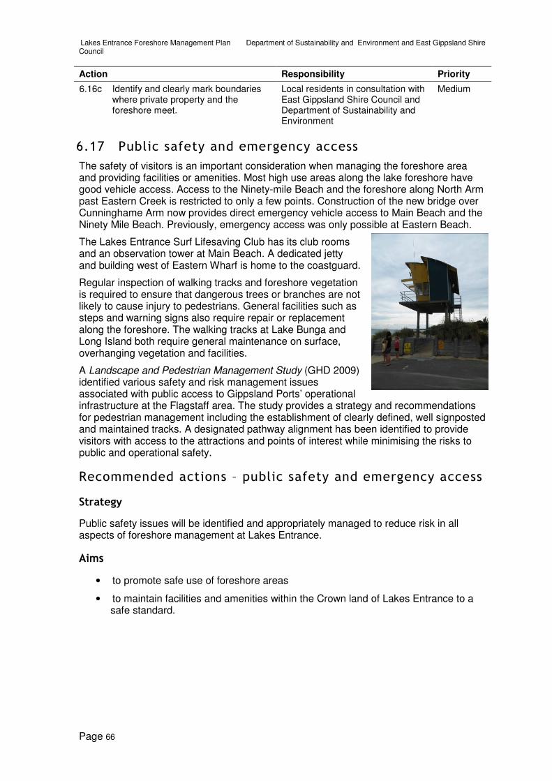
Lakes Entrance Foreshore Management Plan Department of Sustainability and Environment and East Gippsland Shire Council
Page 66
Action Responsibility Priority
6.16c Identify and clearly mark boundaries where private property and the foreshore meet.
Local residents in consultation with East Gippsland Shire Council and Department of Sustainability and Environment
Medium
6.17 Public safety and emergency access
The safety of visitors is an important consideration when managing the foreshore area and providing facilities or amenities. Most high use areas along the lake foreshore have good vehicle access. Access to the Ninety-mile Beach and the foreshore along North Arm past Eastern Creek is restricted to only a few points. Construction of the new bridge over Cunninghame Arm now provides direct emergency vehicle access to Main Beach and the Ninety Mile Beach. Previously, emergency access was only possible at Eastern Beach.
The Lakes Entrance Surf Lifesaving Club has its club rooms and an observation tower at Main Beach. A dedicated jetty and building west of Eastern Wharf is home to the coastguard.
Regular inspection of walking tracks and foreshore vegetation is required to ensure that dangerous trees or branches are not likely to cause injury to pedestrians. General facilities such as steps and warning signs also require repair or replacement along the foreshore. The walking tracks at Lake Bunga and Long Island both require general maintenance on surface, overhanging vegetation and facilities.
A Landscape and Pedestrian Management Study (GHD 2009) identified various safety and risk management issues associated with public access to Gippsland Ports’ operational infrastructure at the Flagstaff area. The study provides a strategy and recommendations for pedestrian management including the establishment of clearly defined, well signposted and maintained tracks. A designated pathway alignment has been identified to provide visitors with access to the attractions and points of interest while minimising the risks to public and operational safety.
Recommended actions – public safety and emergency access
Strategy
Public safety issues will be identified and appropriately managed to reduce risk in all aspects of foreshore management at Lakes Entrance.
Aims
• to promote safe use of foreshore areas
• to maintain facilities and amenities within the Crown land of Lakes Entrance to a safe standard.

Lakes Entrance Foreshore Management Plan Department of Sustainability and Environment and East Gippsland Shire Council
Page 67
Actions
Action Responsibility Priority
6.17a Conduct an annual safety audit of the foreshore assets (including vegetation) to identify risks and recommend appropriate priorities for action.
All parties Ongoing
6.17b Prune and remove any dangerous trees or limbs along the foreshore near facilities or amenities.
All parties Ongoing
6.17c Repair or replace any existing broken access steps, seats, fences.
All parties High
6.17d Maintain emergency access points to Ninety Mile Beach at Eastern Beach and Main Beach.
All parties Ongoing
6.17e Investigate potential of relocating the coastguard to Bullock Island as part of the master plan for Bullock Island.
All parties Low
6.17f Maintain all safety signage. All parties Ongoing
6.17g Minimise, by the use of signage and road or pathway surface treatments, safety hazards where shared pathways cross boat ramp or jetty parking areas.
All parties High

Lakes Entrance Foreshore Management Plan Department of Sustainability and Environment and East Gippsland Shire Council
Page 68
7 Conclusion
Lakes Entrance is a major holiday and boating destination, providing visitors and residents with opportunities to undertake a broad range of recreational and water based activities. Foreshores surrounding Lakes Entrance are extremely diverse in the values and opportunities they provide. Substantial areas are highly developed, comprising built infrastructure, sea walls, jetties, recreation facilities and car parks. This management plan has identified strategies to improve facilities, access and opportunities for recreational activities while protecting natural, cultural and historical values within the study area.
This plan has been prepared with input from government agencies, community groups, private businesses and the public. Comments received on a proposed management plan and discussion paper, and from focus group and public meetings were considered in preparing the final plan.
A business plan encompassing environmental, planning, financial, operating and management parameters, project staging and timing has been prepared as part of the final plan. This will assist in budget planning processes and also serve as valuable input and justification for external funding applications.
A master plan for Bullock Island and a revised master plan for North Arm will be prepared to direct future development and provide detailed concept plans for implementation of specific actions and construction of associated facilities. Concept plans for the Slipway site will be further enhanced and prepared for planning approval. Jemmys Point–Mt Barkley will have a concept plan prepared to determine a preferred future use of this area that could include a viewing area or lookout, picnic tables, visitor information and landscaped setting.
East Gippsland Shire Council, Gippsland Ports and Department of Sustainability and Environment, will work closely with relevant committees of management and community interest groups to manage the foreshore and implement the strategies within this plan.

Lakes Entrance Foreshore Management Plan Department of Sustainability and Environment and East Gippsland Shire Council
Page 69
Appendix 1 Threatened flora and fauna Lists
Table 1 Rare and threatened flora recorded within five kilometres of study area
Common name Scientific name EPBC FFG VROT Number of recordings
Austral Moonwort Botrychium australe L Vulnerable 3
Bluish Pigface Carpobrotus glaucescens
Rare, not otherwise threatened
8
Coast Grey-box Eucalyptus bosistoana
Rare, not otherwise threatened
12
Coast Mistletoe Muellerina celastroides
Rare, not otherwise threatened
4
Coast Stackhousia Stackhousia spathulata
Poorly known, suspected threatened
2
Dune Wood-sorrel Oxalis rubens Rare, not otherwise threatened
5
Eastern Water-ribbons
Triglochin microtuberosa
Rare, not otherwise threatened
3
Jointed Mistletoe Korthalsella rubra subsp. rubra
Vulnerable 2
Limestone Blue Wattle
Acacia caerulescens
V L Vulnerable 4
Limestone Pomaderris
Pomaderris oraria subsp. calcicola
Rare, not otherwise threatened
18
Pinkwood Beyeria viscosa Rare, not otherwise threatened
1
Salt Lawrencia Lawrencia spicata Rare, not otherwise threatened
2
Sandfly Zieria Zieria smithii subsp. smithii
Rare, not otherwise threatened
1
Slender Tick-trefoil Desmodium varians Poorly known, suspected threatened
1
Spicy Everlasting Ozothamnus argophyllus
Rare, not otherwise threatened
2
Spotted Gum Corymbia maculata Vulnerable 1
Spurred Helmet-orchid
Corybas aconitiflorus
Rare, not otherwise threatened
1
Star Cucumber Sicyos australis Vulnerable 2

Lakes Entrance Foreshore Management Plan Department of Sustainability and Environment and East Gippsland Shire Council
Page 70
Common name Scientific name EPBC FFG VROT Number of recordings
Viscid Daisy-bush Olearia viscosa Vulnerable 26
Wallaby-bush Beyeria lasiocarpa Rare, not otherwise threatened
1
Yellow Milk-vine Marsdenia flavescens
Rare, not otherwise threatened
11
Yellow-wood Acronychia oblongifolia
Rare, not otherwise threatened
30
EPBC – Environment Protection and Biodiversity Act 1999
FFG – Flora and Fauna Guarantee Act 1988 (L – Listed under act)
VROT – Victorian rare or threatened species
C – (CAMBA) The China-Australia Migratory Bird Agreement
J- (JAMBA) Japan-Australia Migratory Bird Agreement

Lakes Entrance Foreshore Management Plan Department of Sustainability and Environment and East Gippsland Shire Council
Page 71
Table 2 Rare and threatened fauna recorded within five kilometres of study area
Common name
Scientific name
FFG EPBC VROT Treaty Number of recordings
Australasian Bittern
Botaurus poiciloptilus
listed Endangered 5
Australasian Shoveler
Anas rhynchotis
Vulnerable 40
Azure Kingfisher
Alcedo azurea Near threatened
69
Black Falcon Falco subniger Vulnerable 6
Black-browed Albatross
Thalassarche melanophris
Vulnerable Vulnerable 1
Black-faced Cormorant
Phalacrocorax fuscescens
Near threatened
18
Blue-billed Duck
Oxyura australis
listed Endangered 4
Brown Quail Coturnix ypsilophora
Near threatened
1
Brown Treecreeper (south-eastern ssp.)
Climacteris picumnus victoriae
Near threatened
1
Brush-tailed Phascogale
Phascogale tapoatafa
listed Vulnerable 1
Cape Barren Goose
Cereopsis novaehollandiae
Near threatened
1
Caspian Tern Hydroprogne caspia
listed Near threatened
CJ 118
Chestnut-rumped Heathwren
Calamanthus pyrrhopygius
listed Vulnerable 1
Common Diving-Petrel
Pelecanoides urinatrix
Near threatened
1
Diamond Firetail
Stagonopleura guttata
listed Vulnerable 2
Eastern Curlew
Numenius madagascariensis
Near threatened
CJ 2
Eastern Great Egret
Ardea modesta
listed Vulnerable CJ 233
Eastern Horseshoe Bat
Rhinolophus megaphyllus
listed Vulnerable 2
Fairy Tern Sternula nereis
listed Endangered 66
Glossy Grass Skink
Pseudemoia rawlinsoni
Near threatened
1
Glossy Ibis Plegadis falcinellus
Near threatened
C 1

Lakes Entrance Foreshore Management Plan Department of Sustainability and Environment and East Gippsland Shire Council
Page 72
Common name
Scientific name
FFG EPBC VROT Treaty Number of recordings
Green and Golden Bell Frog
Litoria aurea Vulnerable Vulnerable 1
Grey Goshawk Accipiter novaehollandiae
listed Vulnerable 61
Grey Plover Pluvialis squatarola
Near threatened
CJ 1
Grey-headed Albatross
Thalassarche chrysostoma
listed Vulnerable Vulnerable 2
Grey-headed Flying-fox
Pteropus poliocephalus
listed Vulnerable Vulnerable 2
Ground Parrot Pezoporus wallicus
listed Endangered 2
Growling Grass Frog
Litoria raniformis
listed Vulnerable Endangered 1
Gull-billed Tern Gelochelidon nilotica
listed Endangered 1
Hardhead Aythya australis
Vulnerable 54
Hooded Plover Thinornis rubricollis
listed Vulnerable 101
Intermediate Egret
Ardea intermedia
listed Critically endangered
6
Lace Goanna Varanus varius Vulnerable 2
Latham's Snipe
Gallinago hardwickii
Near threatened
CJ 6
Leathery Turtle Dermochelys coriacea
listed Vulnerable Critically endangered
1
Lewin's Rail Lewinia pectoralis
listed Vulnerable 14
Little Egret Egretta garzetta
listed Endangered 84
Little Tern Sternula albifrons
listed Vulnerable CJ 150
Long-nosed Potoroo
Potorous tridactylus
listed Vulnerable Endangered 23
Magpie Goose Anseranas semipalmata
listed Near threatened
2
Masked Owl Tyto novaehollandiae
listed Endangered 13
Musk Duck Biziura lobata Vulnerable 86
Nankeen Night Heron
Nycticorax caledonicus
Near threatened
44
New Zealand Fur Seal
Arctocephalus forsteri
Vulnerable 2
Pacific Golden Plover
Pluvialis fulva Near threatened
CJ 1
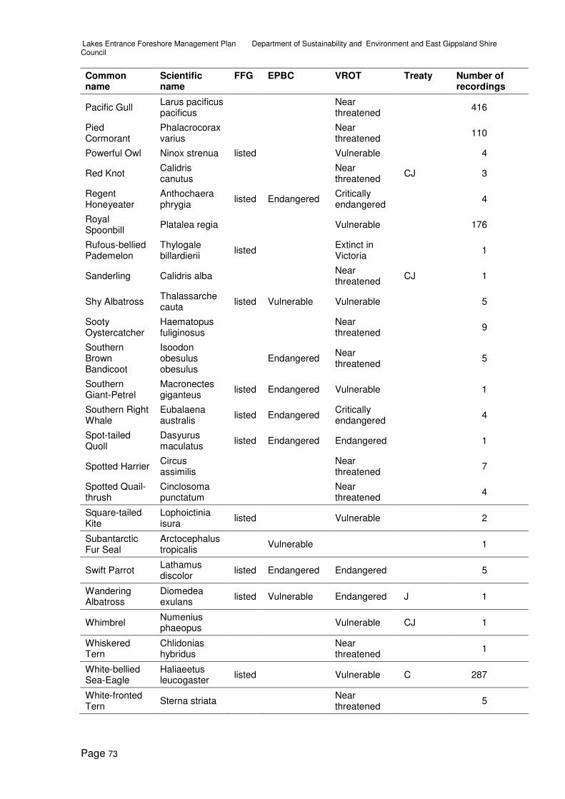
Lakes Entrance Foreshore Management Plan Department of Sustainability and Environment and East Gippsland Shire Council
Page 73
Common name
Scientific name
FFG EPBC VROT Treaty Number of recordings
Pacific Gull Larus pacificus pacificus
Near threatened
416
Pied Cormorant
Phalacrocorax varius
Near threatened
110
Powerful Owl Ninox strenua listed Vulnerable 4
Red Knot Calidris canutus
Near threatened
CJ 3
Regent Honeyeater
Anthochaera phrygia
listed Endangered Critically endangered
4
Royal Spoonbill
Platalea regia Vulnerable 176
Rufous-bellied Pademelon
Thylogale billardierii
listed Extinct in Victoria
1
Sanderling Calidris alba Near threatened
CJ 1
Shy Albatross Thalassarche cauta
listed Vulnerable Vulnerable 5
Sooty Oystercatcher
Haematopus fuliginosus
Near threatened
9
Southern Brown Bandicoot
Isoodon obesulus obesulus
Endangered Near threatened
5
Southern Giant-Petrel
Macronectes giganteus
listed Endangered Vulnerable 1
Southern Right Whale
Eubalaena australis
listed Endangered Critically endangered
4
Spot-tailed Quoll
Dasyurus maculatus
listed Endangered Endangered 1
Spotted Harrier Circus assimilis
Near threatened
7
Spotted Quail-thrush
Cinclosoma punctatum
Near threatened
4
Square-tailed Kite
Lophoictinia isura
listed Vulnerable 2
Subantarctic Fur Seal
Arctocephalus tropicalis
Vulnerable 1
Swift Parrot Lathamus discolor
listed Endangered Endangered 5
Wandering Albatross
Diomedea exulans
listed Vulnerable Endangered J 1
Whimbrel Numenius phaeopus
Vulnerable CJ 1
Whiskered Tern
Chlidonias hybridus
Near threatened
1
White-bellied Sea-Eagle
Haliaeetus leucogaster
listed Vulnerable C 287
White-fronted Tern
Sterna striata Near threatened
5

Lakes Entrance Foreshore Management Plan Department of Sustainability and Environment and East Gippsland Shire Council
Page 74
Common name
Scientific name
FFG EPBC VROT Treaty Number of recordings
Yellow-bellied Sheathtail Bat
Saccolaimus flaviventris
listed 1
Yellow-nosed Albatross
Thalassarche chlororhynchos
listed Vulnerable Vulnerable 2
EPBC – Environment Protection and Biodiversity Act 1999
FFG – Flora and Fauna Guarantee Act 1988 (L – Listed under act)
VROT – Victorian rare or threatened species
C – (CAMBA) The China-Australia Migratory Bird Agreement
J- (JAMBA) Japan-Australia Migratory Bird Agreement
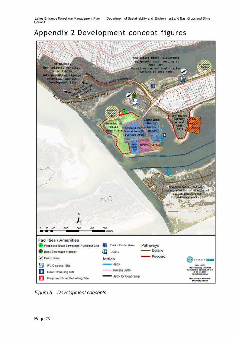
Lakes Entrance Foreshore Management Plan Department of Sustainability and Environment and East Gippsland Shire Council
Page 75
Appendix 2 Development concept figures
Figure 5 Development concepts

Lakes Entrance Foreshore Management Plan Department of Sustainability and Environment and East Gippsland Shire Council
Page 76
Figure 6 Development concepts
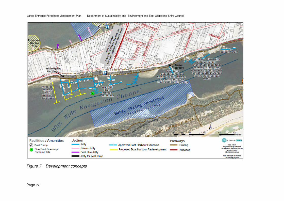
Lakes Entrance Foreshore Management Plan Department of Sustainability and Environment and East Gippsland Shire Council
Page 77
Figure 7 Development concepts

Lakes Entrance Foreshore Management Plan Department of Sustainability and Environment and East Gippsland Shire Council
Page 78
Figure 8 Development concepts

Lakes Entrance Foreshore Management Plan Department of Sustainability and Environment and East Gippsland Shire Council
Page 79
Figure 9 Development concepts

Lakes Entrance Foreshore Management Plan Department of Sustainability and Environment and East Gippsland Shire Council
Page 80
Figure 10 Development concepts

Lakes Entrance Foreshore Management Plan Department of Sustainability and Environment and East Gippsland Shire Council
Page 81
References and relevant strategies BASIS 2008. Gippsland Lakes Boating Amenity and Sustainable Infrastructure Study. Prepared for Gippsland Coastal Board by BECA.
CEAH 2004. Gippsland Lakes Flood Level Modelling Project. Centre for Environmental Applied Hydrology
CFL 1985. Cunninghame Arm Capability Study Prepared for Department of Conservation Forests and Lands by Landsmith Pty Ltd.
CM+CONTEXT 2005. Tara Landing Estate – Land Use Options. Prepared for East Gippsland Shire Council.
DEWHA 2009. Gippsland Lakes – Overview website www.environment.gov.au/cgi-bin/wetlands/ramsardetails.pl?refcode=21. Department of Environment, Water, Heritage and Arts, Canberra 2009.
DHHPM 2007. David Helms Heritage Planning + Management. Archaeological Heritage Impact Assessment for the Sand Redistribution Works, Lakes Entrance, East Gippsland. Volume 2: Historic Heritage Values [Built Structures and Above Ground Objects and Features]. Prepared for Gippsland Ports.
DSE 2003. Gippsland Lakes Ramsar Site Strategic Management Plan, Department of Sustainability and Environment.
DSE 2006. Caravan and Camping Parks on Coastal Crown Land. Victorian Government Department of Sustainability, Melbourne.
DSE 2007. Guidelines and Procedures for Managing the Environmental Impacts of Weeds on Public Land in Victoria 2007. Department of Sustainability and Environment.
DSE 2010a. Conservation and Environment – Victoria’s Bioregions, viewed 23 April 2010.http://www.dse.vic.gov.au/DSE/nrence.nsf/LinkView/EE160E06AD95CA20CA257131000E4170544ABC860B2506F7CA257004002550CC
DSE 2010b. Gippsland Region Fire Protection Plan, viewed July 2010. http://www.dse.vic.gov.au/DSE/nrenfoe.nsf/LinkView/0601385DCAEC77A64A256887002506E0E2B2A8C128CDBC80CA2576580016CE00
EGSC & DSE 1996. North Arm Foreshore and Estuary Action Plan. Prepared for East Gippsland Shire and Department of Natural Resources and Environment by Landsmith Pty Ltd, Vantree Pty Ltd, and Frank Hanson Pty Ltd.
EGSC 1999. East Gippsland Bicycle Strategy Prepared for East Gippsland Shire Council, by Kayleen Summer & Associates.
EGSC 2008. Plan of Management Eastern Beach Tourist Park. Prepared for East Gippsland Shire Council by AUSTPM (Australian Tourist Park Management).
EGSC 2009 East Gippsland Municipal Fire Prevention Plan. East Gippsland Shire
Ethos NRM 2003. Lakes Entrance Surf Beach Precinct Strategic Works Program. Prepared for Department of Sustainability and Environment & East Gippsland Shire Council by Ethos NRM.
GCB 1999. Gippsland Lakes Coastal Action Plan, Prepared for Gippsland Coastal Board, Victoria. Prepared by Vantree in association with Shearwater Environmental Management
GCB 2002. Integrated Coastal Planning for Gippsland – Coastal Action Plan, Prepared for Gippsland Coastal Board by Crossco Engineering & Environmental Consultants, Jennifer Jones Planning Consultants, Landsmith & Shearwater Environmental Management.
GCB 2006. Gippsland Estuaries Coastal Action Plan, Gippsland Coastal Board.

Lakes Entrance Foreshore Management Plan Department of Sustainability and Environment and East Gippsland Shire Council
Page 82
GHD 2009. Lakes Entrance Sand Management Program Landscape and Pedestrian Management Study 2. Prepared for Gippsland Ports.
Gippsland Ports 2010. Flagstaff Management Plan. Prepared by Ethos NRM for Gippsland Ports
LERHS 2010. Lakes Entrance Regional Historical Society – Lakes Entrance History Centre and Museum – Projects, viewed 22 April 2010. http://www.lakes-entrance.com/history/projects.html
Maunsell 2009. DRAFT Lakes Entrance Integrated Planning Project Transport Planning Advice. Prepared for East Gippsland Shire Council. Maunsell Australia Pty Ltd.
Meinhardt Infrastructure & Environment 2007. Lakes Entrance Urban Design Framework. Prepared for East Gippsland Shire and Department of Sustainability and Environment.
Nexus Strategy Group and Ethos NRM 2010. On Water Refuelling and Boat Sewage Disposal Facilities: Risk Assessment, Site Analysis and Feasibility. Prepared for Gippsland Ports, by Nexus Strategy Group and Ethos NRM. July 2010.
Planisphere 2006. Coastal Spaces Landscape Assessment Study. Victorian Government Department of Sustainability, Melbourne.
SEM 1998. (Shearwater Environmental Management). The SS Lady Harriet’s Barge and other relics – Conservation Plan. Department of Natural Resources and Environment.
Tract Consultants 1987. Foreshore Strategy Lakes Entrance. Prepared for Department of Natural Resources and Environment.
VHD 2010. Victorian Heritage Database – New Works Historic Complex, viewed 22 April 2010. http://vhd.heritage.vic.gov.au/places/heritage/641.
VCC 2002. (Victorian Coastal Council) Victorian Coastal Strategy.
VCC 2008. (Victorian Coastal Council) Victorian Coastal Strategy.
Victorian Flood Management Strategy (1998)
Rare and threatened species data source
1. Data Source: 'Victorian Flora Site Database', © The State of Victoria, Department of Sustainability and Environment (accessed via the 'Flora Information System', [March 2010] – © Viridans Biological Databases). The contribution of the Royal Botanical Gardens Melbourne to the database is acknowledged.
2. Data Source: 'Atlas of Victorian Wildlife', © The State of Victoria, Department of Sustainability and Environment (accessed via the 'Victorian Fauna Database', [March 2010]- © Viridans Biological Databases).