lake st. martin crater geology of the surrounding area
TRANSCRIPT
. " ... , -.: ~ ...
~ "
. :6',;, J
.~~--i-~ .. '~
i . , -
GP3/10
MANITOBA MINES BRANCH
DEPARTMENT OF MfNES AND NATURAL RESOURCES
LAKE ST. MARTIN CRYPTO~EXPLOSION CRATER AND
GEOLOGY OF THE SURROUNDING AREA
by
H. R. McCabe and B. B. Bannatyne
Geological Paper 3/70 Winnipeg 1970
..

Electronic Capture, 2011 The PDF file from which this document was printed was generated by scanning an original copy of the publication. Because the capture method used was 'Searchable Image (Exact)', it was not possible to proofread the resulting file to remove errors resulting from the capture process. Users should therefore verify critical information in an original copy of the publication.
•
GP3/10
MANITOBA M]NES BRANCH
DEPARTMENT OF MINES AND NATURAL RESOURCES
LAKE ST. MARTIN CRYPTO·EXPLOSION CRATER AND
GEOLOGY OF THE SURROUNDING AREA
by
H. R. McCabe and B. B. Bannatync
Geological Paper 3/70 Winnipeg 1970
(i)
(ii)
TABLE OF CONTENTS
Page
Introduction' r Previous work I .. Present work 2 Purpose 4 Acknowledgcmcnts 4
Part A - Regional geology and structural setting 4 Post-Silurian paleogeography 10 Post-crater structure 11 Uthology 11
Precambrian rocks 12 Winnipeg Fomlation 13 Red River Fomlation 14 Stony Mountain Formation 15
Gunn Member 15 Gunton Member 16
Stoncwall Formation 16 Interlake Group 16
Summary 17
Part B - Lake St. Martin crypto-explosion crater 33 St. Martin series 33 Shock metamorphism 33
Quartz 33 Feldspar 35 Biotite 35 Amphibole 36 Pseudotachylyte 36
Altered gneiss 37 Carbonate breccias 41 Polymict breccias 43 Aphanitic igneous rocks - trachyandcsitc 47 Post·crater Red Beds and Evaporites (Amaranth Formation?) 50
Red Bed Member 50 Evaporite Member 52 Age of Red Bed·Evaporite sequence 53
Selected References 67 ..
(iii)
Page
Post'Crater erosion' 54 Post-Evaporite paleogeography 56 Origin of Lake St. Martin crater 56 tit
Meteorite impact hypothesis' 56 Volcanic hypothesis 58
~ Comments on meteorite impact hypothesis 58 Comments on volcanic hypothesis 60 Meteoritic-volcanic composite hypothesis 61
Summary 61 Part C - Economic geology 63
High-calcium limestone 63 Silica sand 65 Aggregate material 65 Gypsum 65 Base metals 65 Oil and gas 66
Appendix I 70 Summary logs 70
•
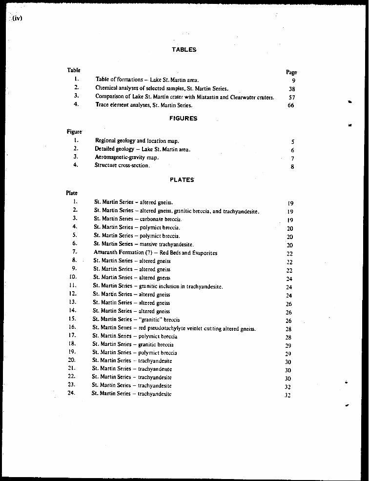
TABLES
Table Page 1. Table' offormations - Lake Sr. Martin area. 9 2. Chemical analyses of select:d samples, St. Martin Series. 38 3. Comparison of Lake St. Martin crater with Mistastin and Clearwater craters. 57 4. Trace element analyses, St. Martin Series. 66
.. FIGURES ..
Figure
I. Regional geology and locarion map. S 2. Detailed geology - Lake St. Martin area. 6 3. Aeromagnetic·gravity map. 7 4. Structure cross-section. 8
PLATES
Plate I. Sf. Martin Series - altered gneiss. 19 2. St. Martin Series - altered gneiss, granitic breccia, and trachyandesite. 19 3. St. Martin Series - carbonate breccia. 19 4. St. Martin Series - polymict breccia. 20 5. St. Martin Series - polymict breccia. 20 6. St. Martin Series - massive trachyandesite. 20 7. Amaranth Formation (?) - Red Beds and Evaporites 22 8. St. Marlin Series - altered gneiss 22 9. St. Marlin Series - altered gneiss 22
ID. St. Marlin Series - altered gneiss 24 II. St. Martin Series - granitiC inclusion in trachyandesite. 24 12. St. Martin Series - altered gneiss 24 13. St. Martin Series - altered gneiss 26 14. St. Marlin Series - altered gneiss 26 15. St. Martin Series - "granitic" breccia 26 16. St. Marlin Series - red pseudotachylyte veinlet cutting allered gneiss. 28 17. St. Martin Series - polymict breccia 28 18. St. Marlin Series - granitic breccia 29 19. St. Martin Series - polymil:! breccia 29 20. St. Martin Series -- trachyandesite 30 21. St. Martin Series - trachyandesite 30 22. St. Martin Series - trachyandesite 30 • 23. St. Martin Series - trachyandesitc 32 24. St. Martin Series - trachyandesite 32
•
LAKE ST. MARTIN CRVPTO-EXPLOSION CRATER
AND
GEOLOGY OF THE SURROUNDING AREA
INTRODUCTION
Thisreport presents a preliminary diSCUSSion of data obtained in a core hole drilling programme in the Lake St. Martin area. The data indicate that the Lake St. Martin structure is a crypto-explosion crateroflate Permian or possibly early Triassic age (2()()'250 m.y.). A structurally uplifted crater rim approximately 14 miles in diameter exposes basal Paleozoic strata and granitic basement rocks within the outcrop belt of Silurian Interlake strata. Immediately inside the crater rim is a complex of down·faulted and brecciated limestone of probable Devonian age; in places these limestones are overlain by 200 feet or more of aphanitic igneous rock (trachyandesite). An inner ring of breccia beds up to 800 feet thick, apparently interlayered with aphanitic igneous rocks, surrounds an uplifted central core 0 f gneissic basemen t rocks shOwing a high degree of shock metamorphism.
The crater may have been formed by a meteorite impact, by an explosive volcanic eruption, or by a combination of both processes; presently available data are not sufficient to confirm any of these hypotheses.
The core hole programme also has provided much additional data regarding Paleozoic stratigraphy and the origin and distribution of the Red Beds and Evaporites in the Gypsumville area.
PREVIOUS WORK
S. I. Dawson, in his geological description accompanying the report of exploration of the Red River Settlement (1859) reported on the remarkable geological relations of the rocks in the Lake St. Martin area, and described two gneissoid islands near The Narrows. Tyrrell, in his detailed report on northwestern Manitoba (1893, p. 203E) described red granite and green soda·rich syenite porphyry in rounded hills in the Lake SI. Martin area; he considered these rocks to be paleotopographic ridges of Precambrian rocks around which the Paleozoic strata were deposited. Tyrrell had described the gypsum deposits of the area in an earlier report (1889).
Bell (1904) referred to the discovery by Charles Camsell of reddish to dark purple amygdaloid'aJ rock in the area east of Gypsum Lake and reported small particles of copper and copper carbonate in the rock, as well as small areas of jasper conglomerate associated with the amygdaloidal rock. In his book, Son of the North (Ryerson Paperbacks No.9), Camsell described his trip to the gypsum area to check on reported occurrences of rock samples containing native copper. "Our copper prospecting trip was a fazzle. We found a very small amount 0 f a copper-bearing conglomerate,
2
but soon came to the conclusion that there was not much chance of finding any body of comme'(cial ore." (p.I64).
WaUace(l925) described amygdaloidallavas with zeolitic infillings and traces of native copper,. and associated hardened tuff beds, in the Lake St. Martin area. An unpublished map in the Manitoba Mines Branch mes,. by Wallace, modified by G. M. Brownell, shows rock exposures in the Gypsumville district of granitic, volcanic,. carbonate, and evaporite rocks.
Another report by Morgan (I 940) describes outcrops of amygdaloidal rock in Sections 13, 14,.23, 24, 2S and 26 of township 33, range 8WPM, and also in sections 18 and 19, township 33, range 7WPM; the area was examined shortly after a fue had passed through the area, and many of the outcrops probably are not normally exposed. Pink pegmatitic granite outcrops to the north of the volcanic rocks, and limestone north of the granite. (nclusions of granite, some several feet in diameter, were reported in the volcanic rocks; amygdales, up to two inches in diameter, of jasper, quartz, zeolite, and carbonate were reported. It should be noted that the full extent of outcrops in the area east of Gypsum lake is not known.
Hunter (1951) carried out the first detailed petrographic work on the granite and volCanic rocks east of Gypsum Lake. at Granite Hill, and in The Narrows area, and distinguished two volcanic rock types, a vesicular porphyritic andesite in the northern part of the area, and amygdaloidal augite andesite in the Sugar Island area.
Because of the relatively young, fresh, unmetamorphosed nature of the volcanic rocks, samples of these rocks were submitted to the Geological Survey of Canada for age determination. The reported ages were 200-250 million years (approximately Permian).
The Paleozoic strata of the area were mapped by Baillie (l9S 1) and Stearn (1956). One ofthe outcrops of "highly weathered hornblende granite", in the NE~ sec. 33, tp. 32, rge.8WPM. was described by Bannatyne (1959) and a suggested extent of the gypsum was indicated from aerial photographic interpretation. A detailed study of the fold structures in the gypsum quarries was made by Hoque (1967); he identified two sets of ridge-forming anticlinal folds. resulting from ice-dragging during the Pleistocene glaciation. Hoque reported also that microfossils found in wen cuttings recovered from red beds at a depth of 160 to 180 feet. in NE~ sec. 26, tp. 32. rge. 9WPM were identified by Dr. W. K. Braun of the University of Saskatchewan as fusuline foraminifera and are believed to be of Permian age. A study of glacial grooving and drag folds in the GypsumvilleSteep Rock area was recently published by Wardlaw. Stauffer, and Hoque (1969).
PRESENT WORK
The Lake St. Martin area has long been of geological interest because of the presence of Precambrian granites and the younger volcanic type rocks. as well as the reported occurrences of native copper. The Manitoba Mines Branch commissioned Lockwood Survey Corporation Ltd. in October 1966 to carry out an aerial photographic interpretation of the Gypsumville-Hodgson area with the primary objective of determing the extent of Precambrian and volcanic rocks in the area. The results of the survey are on file at the Manitoba Mines Branch. A large area in which Precambrian rock either formed the bedrock or was close to the bedrock surface was inferred in townships 32 to 34, ranges 7 to 9WPM in the lake SI. Martin area; in the High Rock Lake area northwest of Hodgson. the survey indicated a 6-mile by 8-mile area in which Precambrian rock is at or
..
•
..
close to the surfilce, in townships 28 and 29, range 2WPM.
During an oil and gas exploration programme in the latter part of 1966, Bralorne Petroleum Limited drilled two exploratory wells in the area. The Bralome Hilbre 8·30-29·8WPM well intersected a normal Paleozoic section near the south end of lake St. Martin; the Bralome Gypsumville 8·20-32-8WPM weD, located 8 miles southwest of the Precambrian inlier at Granite Hill, was drilled to test the possibility of stratigraphic pinch·outs. The latter hole was drilled through red beds into a thick section of "granitic breccias", at first thought to be granite wash on the nank of a Precambrian high, but later identified as a tuff·breccia type of deposit; it reached a total depth of 1055 feet, where granite was encountered some 300 feet below the extrapolated regior.31level of the Precambrian surface • These driD results indicated that the occurrence of granitic and volcanic rocks in the lake St. Martin area was not a simple paleo topographic inlier of Precambrian basement rocks but was a much more complex structure. Small black glassy nodules were recovered in chip samples near the base of the hole, lending credence to the reported Permian age date for the volcanic·type rocks found in the Lake'
St. Martin area.
Within the terms of the F .R.E.D. - agreement for the Interlake Area of Manitoba, a diamond driller training programme was planned for the residents of Indian reserves, and after consultation among the Geology Division of the Mines Branch, E. W. Somers of the ARDA-FRED Adminstration,. E. O. Ens of the F .R.ED. Manpower Corps, J. Ferguson of the Department of Education, and others, it was decided to carry out the programme in the Gypsumville·lake SI. Martin area. The drill hole locations were to be designated by the Geology Division so as to obtain a maximum of useful geological data. One incident that sparked additional interest in this area was the finding of a fragment of chalcopyrite in undisturbed glacial till at a depth of 3 feet in an excavation to serve the Community Education Centre on The Narrows Indian Reserve.
During the drill programme. from August to December. 1968, a total of 17 drill holes were completed. The drill used had a limited capacity of approximately 100 feet in overburden and 500 feet total depth; 7 drill hole locations had to be abandoned in thick overburden before bedrock was reached (Appendix I and Fig. 2). A total of approximately 2.500 teet of bedrock was cored in the other 10 holes; total footage drilled in the 17 holes was 3.360 feet.
Permission to drill a hole in the quarry north of Gypsumville was granted by Domtar Cons· truction Materials Umited.
A licence to prospect on the Lake SI. Martin and Little Saskatchewan Reserves was granted through Band Council Resolutions and by the Indian Affairs Branch, Department of Indian Affairs and Northern Development.
Following preliminary reports on the presence of a possible crater structure in the area (Summary of Geological Fieldwork. 1968, 1969), the writers were contacted by K. L. Currie, Ge~ 1000cal Survey of Canada, and M. R. Uence, Gravity DiVision. Earth Physics Branch, Department of Energy, Mines and Resources. Currie examined some of the drill core and made a trip to the lake St. Martin area with one of the authors. H. R. McCabe, in July. 1969, to examine outcrops and to obtain oriented core samples of the trachyandesite for paleomagnetic determinations. Selected
-Fund for Rural Economic Development. set aside by the Federal Governml!nt to be used to boost the economy of designated rural areas in each prOvince.
3
4
samples from the driU core were sent to M. R. Dence. who kindly prepared a petrographic report with 64 photomicrographs., that proved ofinvaluable assistance especially in the recognition of shock met· amorphic features in the St. Martin structure. Both Dence and Currie (personal communication) note the similarity of the Lake St. Martin structure to other Canadian craters, especially the Mistastin and Clearwater Lakes craters. but their intepretations differ considerably. Dence (in French and Short, 1968) would attribute the craters to meteorite impact, whereas CUrrie (1968, 1968a) believes they are' of volcanic origin; this same controversy applies to many crypto·explosion structures throughout the world.
PURPOSE
The purpose of this report is to present a genera! outline of the litholOgic,. petrographic and morphologic features associated with the Lake St. Martin crater, and to outline the regional geology of the area. It must be stressed that this study is of a preliminary nature and a great deal of detailed mineralogical, petrographic, geophysical and geochemical work remains to be done, especially with regard to the extremely complex effects of shock metamorphism; it is hoped that this paper will pro-, vide a basis for such future studies.
ACKNOWLEDGEMENTS
The writers gratefully acknowledge the comments and advice of M. R. Dence and K. L. Currie •. but they are to be held in no way responsible for any interpretations or conclusions arrived at by the authors of this report.
Age determinations of Precambrian and trachyandesite rocks were made for the Manitoba Mmes' Branch by the Isotope and Nuclear Geology Section of the Geological Survey of Canada at the request of Dr. J. F. Davies, then Chief Geologist of the Manitoba Mines Branch. Samples of various lithologies were checked for suitability for Rb·Sr age determinations by Dr. A. Turek of the Manitoba Mines Branch at the Isotope Geology Branch, United States Geological Survey Lab· oratory in Denver.
PART A. REGIONAL GEOLOGY AND STRUCTURAL SETTING
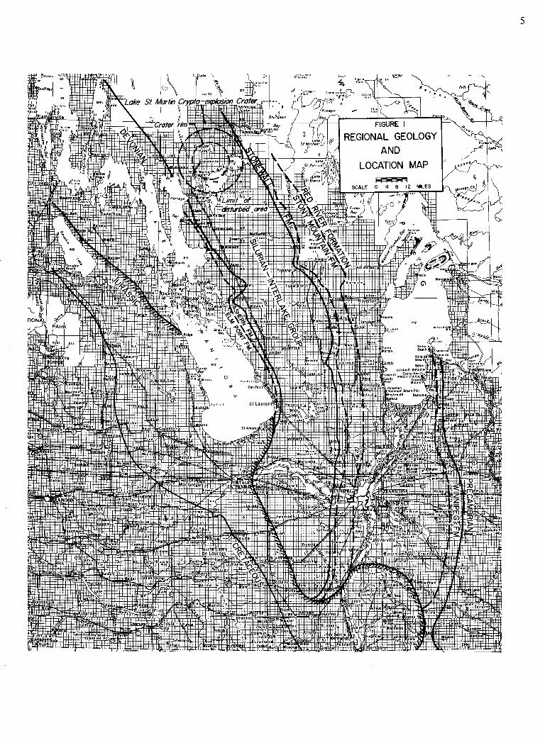
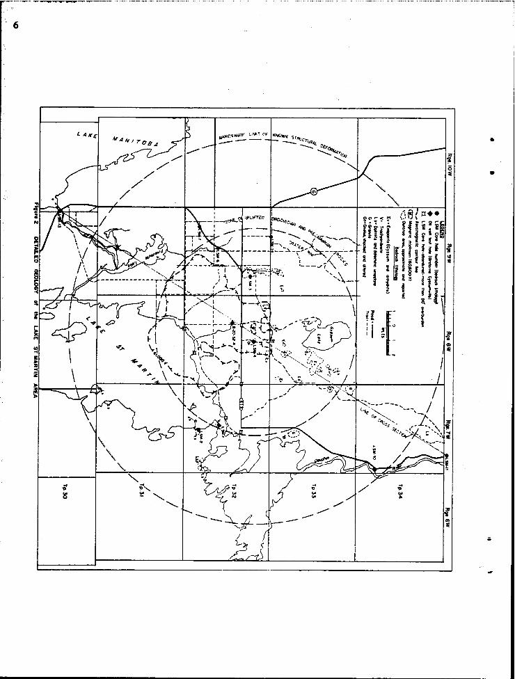
The Lake St. Martin structure is located in the Interlake region approximately 150 miles north of Winnipeg. The area is easily reached via Provincial Trunk Highway 6 and Provincial Road 513 (Fig. I). Physiographically this area comprises part of the Manitoba Plain or First Prairie Level. It is underlain, in all areas except the crater itself, by lower Paleozoic carbonate rocks of Ordovician and Silurian age. A generally thin mantle of glacial till and reworked g1al.;allake deposits covers the area and severely limits the amount of outcrop to less than I per cent. All known or reported outcrops are shown in Figure 2. In addition much of the area is low lying and swampy, making access to most of the outcrop areas in the northern part of the structure very difficult. A network of roads gives good access to the southern part of the area, but unfortunately this area, for the most part, is underlain by an unusually thick section of drift matelial, generally in excess of 100 feet.
The Lake St. Martin crater occurs within the regional outcrop belt of the Silurian Interlake Group (Fig. I) where the expected thickness of lower Paleozoic sedimentary strata is approximately 700 feet (Table I). The strata are virtually flat lying. haVing a present dip of only 10 feet per mile to the west southwest. In the immediate vicinity of the crater, however, pronounced structural up· lift of at least 700 feet has brought to the surface basal Paleozoic strata and Precambrian granitic
•
'6
I /
•
•
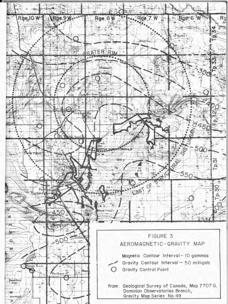
FIGURE 3
AEROMAGNET Ie - GRAVITY MAP
Magnetic Contour Interval- 10 gammas
,..,./ Gravity Contour Interval- 50 milligals
o Gravity Control Point
from : Geological Survey of Canada, Map 7707 G. Dominion Observatories Branch, Gravity Map Series No.49
",,/
~// zoo ~~~/~ I//;~ rL/ ,.,; // i I ,-v- , .. ftc y , '
, I ..... cr.,," ' I I ~~cf/.~t- I
iI: I ~"k: .", ' I' -, ,_..,./ .,0 I I I::rJ/ ~I' ~ 1 ~ I
100 'T, , .... ..h.1 ~ ..:
A /. A
REO BE05
00
! --lIitncc""'"'''4(C,.""WC''''' em 44 ~
?-~~~-? ~~[ ~ •
....... ' .m. /. .... 0 -- ,..--,... ..,.--"
1-
~ I ~k ~, ~~
'h. '1-(J"''It>. "'..;"> ~ '\. '».. "0." '\,~ I -
\P.,;"> '4< ~~'f'..,~ F.l11 'to ~ ~I I '\0.,. ~'f." III
\"~ I
~~\~l ~, I ~' I ~"-- ~: I "'I I '" I • ' , ~I ,
I" /or" 11-.00 ,../ II
~ii ............. ''»j.~ .............
, ~"1IINNIP£6
/ttr,. ~I I . I I I I I ./ °1 I /.. I I ,
., ' /. .... ,<1' ' I .,1 il' 1_ _ .--:::.;;;. ," JM ~I: /,' fif7' ~~ V/ .,-rt1.ff,;,' .. •• ST~'tA
. I»...! I
-------~ I"F- 100 ~ / ~'6f/.\t-" I I ft;6-c-
I I A11 ~~ ' ___ -----"'~ .. -""""""~O-"""""
l
PLEISTOCENE kcl'OI JURASSIC AMARANTH
fORMATION (?I
ST. MARTIN S£RIES
~ PALEOZOIC ~
VERTICAL EXAGGERATION .80 PR£CAMlRIAN I .. •
fiGURE 4 STRUCTURE CROSS SECTION .... ~ M'" 10'01" I, pro,., ,",tlO. ,.1"'.0 '0 C'"'' '1., ......... ""'''' of •• .et... Ete¥ltlOttt of •• ~ N,. D ........ , ••• 0 c ......... 'Of • .,.c ...... *'1." • .., .......... I ......... ,,_ ''''''Nt'' ",0" re ..... • , ....... S_ 7.10, ... II ~o, • ...... 'rapo1 •••• I. '.,per .. 'i.ON ...... coat"'''1NI 0' 1M n~ Ifr01.-llfec ........... 1M ."., ,enl 0' , .. INN',
~,
GIoe: ............ 0."
£wo,an'., RM .. ..
T.oc~, ..... ~. .... 111; oM , ..... INncl~
Co""" "'ICC~ _ ...... _11 .. 11_;_
Gr.ItIC roc.~
,........ f ••• cr ..... 'I~
c.,.. ........ Ii ... (4. A.' ..-c ... .,u, .. 'lect otNc.., •• ,.n ... ,. ... ,." •. ., ....... .
, .' 00
•
TaMe [
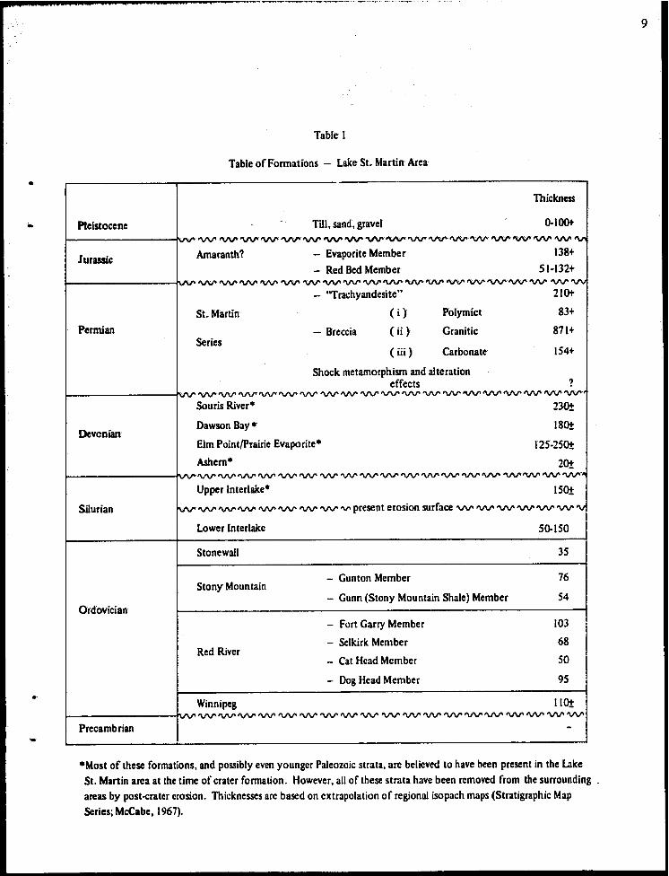
Table of Formations - Lake St. Martin Area
Thickness
Pleistocene Till,. sand,. gravel 0-100+
-~~~~~~~~~~~~~-~~~~-
Jurassic Amaranth? - Evaporite Member 138+
- Red Bed Member 51·132+ • A· .... ~ ~.~.~ 'V'V'. 'VV' ~~ ~'V'V'.'VV" ~ ~ 'VV"'V'V'.~.~ ~ 'V'V
- "Trachyandesite" 210t
St. Martin ( i) Polymict 83+
Permian - Breccia (ii) Granitic 871+ Series
(iii) Carbonate 154+
Shock metamorphism and alteration effects ?
·A .~.~ ~.~.'V'V' ~ ~ 'I/V' 'VV' 'V'V' 'VV' 'VV' 'VV''VV' 'V'V' ~.~.~~.
Souris River· 230±
Devcnian Dawson Bay· 180!
Elm Point/prairie Evaporite· 125·250!
Ashern· 20t .~~'VV'~'V'V'~~'I/V''VV''V'V''VV'~'VV'~'VV''VV'~~~
Upper Interlake· ISO!
Silurian ivv' 'VV' ~ 'VV' ~ 'VV' ~ ~ 'V' present erosion surface 'VV' ~ 'VV' 'V'V' ~ 'V'V' '"
Lower Interlake 50-ISO
Stonewall 35
Stony Mountain - Gunton Member 76
- Gunn (Stony Mountain Shale) Member 54 Ordovician
- Fort Garry Member \03
- Selkirk Member 68 Red River
- Cat Head Member SO
- Dog Head Member 95
Winnipeg I lot I"'" 'VV' ~ 'VV' ~ 'V'V' 'V'V' 'VV' 'VV" 'VV' 'V'V' 'VV' ~ 'VV' 'VV' 'V'V' ~ 'VV' 'VV' 'VV"
Precambrian -
.Most of these formations, and possibly even younger Paleozoic strata. are believed to have been present in the Lake St. Martin area at the time of crater formation. However. all of these strata have been removed from the surrounding . areas by post-cratcr erosion. Thicknesses are based on extrapolation of regional isopach maps (Stratigraphic Map Series; McCabe, (967).
9
'10
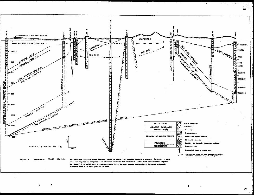
rocks (Fig.4);effecfive dips on the flank ofthe crater are estimated to be 300 to 400 feef per mile,. or 4 0 to 50
Although data are sparse (here appears to be an uplifted, roughly arcuate rim of granitic and basal Paleozoic strata around the eastern flank of the structure. Hole LSM·7 indicates the presence of a similar uplifted rim in the western flank of the structure; in this hole, however, known uplift is only about 200 feet, as indicated by the occurrence of the "Stony Mountain Shale" marker at a depth of only 102 feet, relative to a regional expected depth ofJOO feet. Hole LSM·7 is interpreted as being located approximately I ~ miles southwest of the crater rim and it is suggested that greater uplift may occur between holes LSM-6 and LSM·7.
In view of the above data and the previously noted similarity between the Lake St. Martin structure and other crater structures in Canada it seems highly probable that the Lake St. Martin structure is also roughly circular in outline. Certainly, the 14-mile diameter circle superimposed on the geological map (Fig. 2) appears to fit the available geological and structural data very closely. If the structure is in fact circular and symmetrical, it follows that an uplifted rim of basal Paleozoic strata (Red River and Winnipeg Formations), and possibly Precambrian rocks, exists around the entire 44-rnile circumference of the crater, even though outcrop evidence for this rim is lacking on the northwestern flank of the structure.
Hole LSM·IO, approximately 4 miles northeast of the postulated crater rim, shows only minor uplift of possibly 100 feet. The section in LSM-Il appears to be lithologically normal, and the elevation ofthe Winnipeg and Stony Mountain marker horizons appears to be normal. These data suggest that the structurally disturbed and uplifted area extends only 6 or 7 miles beyond the crater rim, so that the maximum diameter of the structural disturbance is approximately 26 to 28 miles.
The original depth of the crater is uncertain, but the present difference in elevation between the uplifted granitic rim and the base of the breccia beds in the Bralorne 8·20-32·8WPM well (not the base of the in-situ brecciated and shocked basement rocks) is approximately 1050 feet. Reconstruction of the Paleozoic rim of the crater suggests an original depth in excess of 2000 feet. Furthermore, the apparent base of the Bralorne breccia at 1042 feet may not represent the maximum depth of crater excavation.
Within the crater rim there exists a complex sequence of faulted and brecciated carbonate rocks,granitic breCCias, polymict breccias. aphanitic igneous rocks (trachyandesite), and highly shock. metamorphosed basement gneisses. These rocks are designated as the St. Martin Series; age deter· minations of these rocks indicate a probable late Permian age (200·250 m.y.).
Overlying the breccia beds of the St. Martin Series is a flat·lying sequence of red beds and evaporites that are believed to be of Jurassic or Jura·Triassic age and at least in part correlative with the Amaranth and Watrous Formations of southwestern Manitoba and Saskatchewan. These red beds and evaporites apparently comprise an outlier and are not known to occur between the crater area and the Amaranth outcrop belt.
POST-SILURIAN PALEOGEOGRAPHY
Although nothing is known directly of the geological sequence of events between middle Silurian (Middle Interlake) time and middle Jurassic (?) (Amaranth) time, it is necessary to have some
idea onhe paleogeography of the Lake St. Martin area in late Permian time - the time of crater formation - in order to determine the origin of the crater.
EXamination of regional structure and isopach data indicates that the Lake St. Martin area is located on the northeastern flank of the Williston Dasin. This basin, centered in northwestern North Dakota, was the dominant tectonic element throughout much of the middle Silurian to middle Jurassic time period. The other principal tectonic element, the Elk Point Basin centered in south-central Saskatchewan, controlled depositional patterns throughout most of Devonian time.
Regional isopach maps of southwestern Manitoba (McCabe, 1967; Stratigraphic Map Series) show that the present, erosionally controlled, outcrop belts bear little or no relation to the depositional patterns of the units. Extrapolation of the isopach trends from southwestern Manitoba to the Lake St. Martin area are speculative, but suggest that possibly a thousand feet or more of upper Paleozoic strata were laid down in the Lake St. Martin area during middle Silurian to roughly middle MissiSsippian time. Tectonic subsidence and deposition, related to the Williston and Elk Point Basins, probably were dominant during this time, except tor the period ofpost-Silurian, pre-Middle Devonian erosion during which all of the Upper Interlake strata were I!roded in southwestern Manitoba. From approximately middle Mississippian (Mission Canyon-Charles) through middle Jurassic time, the regional isopach and lithofacies data suggest a change in the tectonic pattern so that uptift and erosion became dominant on the fl;.nks of the basin, with deposition occurring only in the more central parts.
The Lake St. Martin crater, of late Permian to possibly early Triassic age, was thus formed during a period when extensive uplift and erosion of Paleozoic strata probably was taking place. Although there is no way of determining accurately how much erosion had occurred at the time of crater formation, indirect evidence suggests that a minimum of at least 300 feet of upper Paleozoic (upper Silurian and Devonian) strata were present. As will be discussed later, this evidence consists of high-calcium "Devonian·looking'· limestones in the carbonate breccia beds of the St. Martin Series. This means that at least 300 feet of erosion has taken place in the area immediately sur· rounding the St. Martin structure since the time of crater formation. The possible amount of preRed Bed erosion within the crater will be discussed in a later sectiun.
POST-CRATER STRUCTURE
It has been pointed out that the present dip of Paleozoic strata in the Lake St. Martin area is approximately 10 feet per mile (00 6') to the west-southwest. A comparison with the area to the southwest suggests that approximately 60 per cent of the regional dip was imposed on the area during post·middle Jurassic (Red Bed) time. It would thus seem reasonable to assume that, in the Lake St. Martin area, 60-70 per cent or more of the present dip, or roughly 6-7 feet per mile, has been superimposed on the crater structure since Permian time. Over the l4-mile diameter of the structure this would amount to approximately 100 feet of post-crater tilting. The combination
of pre·crater dip (34 feel per mile) and post·crater tilting probably accounts in part for the lack of outcro ps on the western ha I f a f the cra ter rim.
LITHOLOGY
The following discussion of the Precambrian and Paleozoic geology of the immediate Lake St. Martin area will be based in part on the subsurface data shown in the structure contour-isopach maps of the Stratigraphic Map Series, but primarily on data from two test holes flanking the crater structure. These are Bralorne Hilbre Prov. 8-30-29-8WPM,located approximately 12 miles south of the crater rim, and core hole LSM-II,located about 9 miles northeast of the crater rim. Both of
11
I:!
these' wells appear to show normal undisturbed sections that conform closely to the regional structural
and isopach patterns.
PRECAMBRIAN ROCKS
Precambrian basement rocks in the Lake SI. Martin area comprise part of the Superior Pre· vince of early Precambrian age. A sample from Granite Hill, on the eastern rim of the crater, gave a potassium-argon age determination of 2387 m.y., considered to be a normal Superior age. The Precambrian rocks are overlain by approximately 700 feet of lower Paleozoic sands, shales and carbonate rocks, except for the area of the crater itself where uplifted Precambrian rocks outcrop along the eastern rim of the crater. In addition, two small basement outcrops occur in the uplifted core of the crater (Fig. 2).
The nearest occurrence of Precambrian basement rocks is north of High Rock Lake (sec. 8, tp. 29, rge. 2WPM), approximately 30 miles southeast of Lake SI. Martin, where another granite inlier is present at an elevation approximately 500 feet above expected regional elevation. The main Precambrian Shield area lies 60 miles to the northeast. Since no other pronounced basement highs are known in southwestern Manitoba the possibility exists that the granite inlier at High Rock Lake may also indicate a crater structure similar to the Lake St. Martin crater. The granite outcrop near High Rock Lake is exposed in two long ridges; no other rock types are known to occur. Access is very difficult. The outcrop is located on the northwestern edge of a small (130 "'1 ) magnetic low about 4 miles in diameter (Federal-Provincial Aeromagnetic Map 4166G).
All of the basement rocks outcropping along the Lake SI. Martin crater rim are of granitic composition and have been identified as oligoclase granite. pink biotite granite, microcline granite, fine-grained aplitic granite and pegmatite. All of these outcrops have been described by Hunter (195 I). The rocks generally arc massive and relatively uniform although some more basic inclusions are noted. Quartz shows strong undulatory or strained extinction. but there is no evidence of any other features that might indicate shock metamorphism; undulatory extinction of quartz. by itself, is too common a feature to be considered indicative of shock metamorphism. These appear to be normal. unaltered but uplifted basement rocks.
The shock·metamorphosed core of the crater consists of an altered granitic or amphibolitic gneiss; lithology of this unit will be discussed more fully in a following section on shock metamorphism and alteration as related to crater formation.
Some idea as to the regional nature of the Precambrian basement can be obtained from the Federal·Provincial aeromagnetic maps (Nos. 4183G. 4184G, 4199G, and 420OG). To the east •
. in the Precambrian Shield outcrop area, the rocks of the Superior Province show a general pattern of roughly cast-west trending volcanic-sedimentary (greenstone) belts separated by large areas of granite and paragneiss; the lithologic pattern is reflected in the aeromagnetic rnaps which show a series of cast-west trending magnetic highs associated with the greenstone belts. In the area of the Lake St. Martin structure, however. a prominent, roughly circular magnetic low interrupts the general ea~t-west trend of the anomaly pattern. The 61,0001 contour outlines a prominent closed low offset somewhat towards the southern half of the crater (Figs. 2.3). When a plot was made to find the best fit of the known geology to a circular crater pattern, without reference to the magnetic contours, the geologically and structurally defined center of the crater was found to fall in the south-center of Section 33, Township 32, Range 8WPM (Fig. 2), only 14 mile east of the magnetic
minimum« 60.000' r }.and ~ mileweslllfhole LSM4 which was collared in the outcrops of shockmetamorphosed basement gneiss. This suggests a close correspondence of the magnetic anomaly with the geological/structural anomaly. Although the overall fit of the magnetic contours to the postulated 14 mile circular crater outline is by no means perfect. the magnetic contours generally show a parallelism to the crater rim, and for approximately 6 miles beyond the crater rim.
There is no evidence that the Lalee St. Martin crater structure is located on any major Pre· cambrian tectonic trend that could have served to localize crater formation. There is no' suggestion, in the magnetic maps, of any trend connecting the Lake St. Martin structure with the previously mentioned High Rock Lake granite inlier. It should be noted, however, that Currie (1965) has postulated a broad regional tectonic control relating the occurrence of "volcanic" craters to the apparent axis of major Precambrian shield uplift in late Paleozoic time.
The regional gravity map of the Gypsumville area (Dominion Observatories Branch. Gravity Map series No. 49, 1965) (Fig. J) shows a poorly defined gravity low of possibly 20·50 milligals in
the crater area. However. only 6 gravity stations were located within the crater so it is not possible to show any correlation of gravity features with geologic features such as depth to basement, shock
metamorphism, etc. It is hoped that subsequent studies will include a number of detailed gravity and magnetic traverses across the crater.
One other aspect of Precambrian basement lithology should be noted. and that is the presence of a weathered zone below the basal Paleozoic Winnipeg beds. Very little information is
available as to the thickness of this weathered zone, but is probably is quite variable. depending on the topography of the erosion surface and the lithology of the basement rocks. For example, 10 feet of IUghly kaolinized granodiorite was encountered in a core hole at Grand Rapids. Undoubtedly a zone of weathered Precambrian rock was present in the Lake 51. Martin crater area and fragments of this weathered rock probably have been incorporated into the breccias and trachyandesites of the St. Martin Series. The considerable variation in degree of alteration of granitic fragments may thus, in part, reflect pre·Ordovician weathering as well as alteration associated with crater formation.
WINNIPEG FORMATION
The Ordovician Winnipeg Formation comprises a complex series of interbedded sands and shares deposited on the eroded and weathered Precambrian surface. Marked lateral facies changes from sand to shale are evident in the subsurface of southwestern Manitoba. but in the general Lake St. Martin area sandstone appears to be the dominant lithology.
In the Hilbre 8·30·29·8WPM well. the only hole in the map·area to have completely pene· trated the formation, Winnipeg strata are 130 feet thick: electric logs indicate that the unit con· sists of roughly 80 per cent sandstone and 20 per cent shale. The sandstone is poorly consolidated to unconsolidated. medium to coarse grained, highly quartzose, and the grains arc extremely well
rounded and frosted. Sand from the Winnipeg Formation is quarried at Black Island. 90 miles southeast of the map-area. as a source of glass sand. The shale is smooth. wa.xy appearing, non· calcareous. kaolinitic. in parI sandy and silty. and varies in color from pale greenish grey to reddish brown. purpli:;h red and olive brown.
The regional isopach of the Winnipeg Formation shows a general. although irregular. de· crease in thickness towards the north; the expected thickness of the formation in the crater area is 100·120 feet; the normal or expected elevation of the top of the Winnipeg is +250 feel. or ap· proximately 550 feet below ground.
13
14
Hole LSM-2, located on the southeast rim of the crater, encountered shales of the Winnipeg
Formation at a depth of 37 feet (vertical) and unconsolidated sand at 48 feet (vertical). Because
of poor hole condition the hole was abandoned after penetrating 20 feet of unconsolidated sand.
Approximately 7 miles northeast of the crater, at a depth of 493 feet, hole LSM·ll encountered 12
feet of mottled purplish and reddish to greenish grey, sandy, slightly pyritic shale comprising the
upper part of the Winnipeg Formation.
Although no outcrops of Winnipeg Formation have been reported in the area,. a white sand
beach occurs a short distance north of hole LSM-2 indicating that the Winnipeg sand may occur
beneath a thin glacial cover_
RED RIVER FORMATION
Regional studies of the Red River Formation show that the formation thins fairly rapidly
towards the north, and this thinning is accompanied by a general increase in the degree of dolomitiz·
ation. The expected thickness of the Red River Formation in the lake SI. Martin area is approximately
325 feet.
The northward change in lithology and thickness is directly reflected in the north-south trending
ouicrop belt which, in effect, comprises a dip-section of the unit. These lateral variations along the
outcrop belt have giilen rise to some uncertainty in detinition and correlation of stratigraphic subdivisions
of the Red River Formation. Early usage (e.g. Baillie, 1952) subdivided the formation. in ascending
order, into Dog Head (lower mottled limestone), Cat Head (cherty dolomite), and Selkirk (upper mottled
limestone) members. Later subsurface studies (Andrichuk, 1959) showed the presence of an uppermost
thick, 13()'foot section of dolomite containing several thin argillaceous, evaporitic and calcareous markers;
this unit was later nanled the "Herald Beds" (Saskatchewan Geological Society, 1958) from its occur·
rences in the Imperial Herald 1·31-1-20W2 well in south·central Saskatchewan, and had no known counter
part in the Manitoba outcrop section.
Sinclair (1959). partly on the basis of faunal studies, suggested that the Cat Head member was
correlative with the upper dolomite unit and proposed a two-fold subdivision of the Red River outcrop
section into Dog Head and Cat Head Members.
On the basis of examination of core obtained from subsequent drilling in the south Interlake,
Lake St. Martin, and Grand Rapids areas. it appears that Sinclair's proposed subdivision is not correct.
A cherty dolomite unit docs occur between upper and lower mottled limestone units. and these units
are in turn overlain by a thick dolomite unit correlative with the Herald Beds. This dolomite unit
forms a prominent marker bed in several of the Lake SI. Martin core holes, and several exposures are
now known. in particular in a quarry 10 miles north of Winnipeg. The term Fort Garry Member is
. hereby proposed for this predominantly dolomite unit comprising the upper part of the Red River
Formation; it is overlain with apparent conformity by the calcareous shales and argillaceous lime
stones of the Gunn Member of the Stony Mountain Formation. and underlain with apparent con·
formity by the limestones and dolomitic mottled limestones of the Selkirk Member of the Red
River Formation.
The type outcrop section of the Fort Garry Member is in the quarry of Mulder Bros. Sand & Gr.wel
Ltd., sec. 27, tp. 13, rge. 3EPM. Only the middle 14 feet of the section is exposed in the quarry (sec
description in Appendix). The closest complete subsurface reference section is Sun Test Hole No.7
(24-11·IWPM); descriptions are included in the Appendix.
The proposed stratigraphic sUbdivision of the Red River is shown in TaMe I, and the descriptive lithology is as fonows. The Dog Head Member comprises a mottled dolomitic limestone similar to the well known ''Tyndall'' building stone; it is essentially a biomicrite with a distinctive, irregular. almost tubular dolomite mottling. The dolomite mottles are almost pure dolomite, and the biomicrite matrix is almost a pure high calcium limestone. This unit is probably the most uniform in lithology of any of the Red River units and shows little variation from the Winnipeg area to the lake SI. Martin area. Thickness in hole LSM-Il is 83 feet.
The bottom 37 feet of the Dog Head was intersected in LSM-2. which was collared in outcrop on the southeast rim of the crater. This outcrop of Dog Head had formerly been miscorrelated with the Stony Mountain Formation because of the reddish, calcareous, and somewhat argillaceous nature of the basal part of the unit. The outcrop shows a very rubbly fractured surface and no determination of structural attitude was possible, although photogeologic studies indicate an anomalous dip to the southeast in this area (Lockwood Survey Corporation Ltd., 1967).
The Cat Head Member was encountered only in hole LSM-Il where it comprises 50 feet of cherty. slightly to moderately calcareous, micro-ctystalline to very rmely crystalline dolomite.
The lithology of the Selkirk Member is !iOmewhat anomalous in the Lake St. Martin area. Normally this unit consist! primarily of the typical mottled "Tyndall" dolomitic limestone, essentially identical to the previously described Dog Head. In the Lake St. Martin area, however,. hole LSM-ll showed the Selkirk to consist of 75 feet of interbedded high calcium limestone (crinoidal biosparite and biomicrite), and streaked, banded and mottled coarsely microcrystalline dolomitiC limestone and calcareous dolomite; the typical ''Tyndall'' mottling was not developed. A possible explanation of this "abnormal" lithology in an otherwise very uniform litholigic unit, is that this represents the original depoSitional texture of the unit prior to organic (?) reworking. Several "burrows" were observed in banded portions of the core.
The Fort Garry Member. as encountered in the LSM-II hole. is approximately 96 feet thick and consists primarily of microcrystalline, dense to slightly granular or sublithographic. massive, tight. hard dolomite. Minor vuggy porosity occurs in some bands; color is dominantly light grey to yellowish buff but some intervals show a prominent dark purplish grey color mottling. Some intervals are slightly to moderately argillaceous and show a fine fragmental texture. Near the top of the unit is a IS-foot zone that is dominantly limestone with minor dolomite interbeds; several breccia zones with a calcareous shale matrix an: also present in this zone. The breccias appear to be of normal sedimentary origin rather than tectonic breccias, and may possibly be the result of evaporite solution.
Hole LSM-IO apparently started coring in the base of the Gunn Member and cored virtually the complete section of the Fort Garry Member. Hole LSM-7 encountered 31 feet of the upper part of the unit at a depth of 149 feet. Minor lateral changes in lithology are evident be. tween the above holes.
STONY MOUNTAIN FORMATION
GunnMember
The Gunn (Stony Mountain Shale) Member of the Stony Mountain Formation provides a distinctive and correlatable lithologic marker in the Lake St. Martin area. In the type area of
15
16
southern Mimitoba' this- unit consists of interbedded calcareous shale and argillaceous, fossil-fragmental limestone. The calcareous and argillaceous content, however, decreases rapidly to the north so that in the Lake St. Martin area the unit consists of a streaked and mottled argillaceous dolomite 54 feet thick., The mottling has a distinctive fine tubular, vermiform appearance. The Gunn Member was encountered in hole LSM-II at 122 feet and in hole LSM-7 to 102 feet.
Gunton Member
Throughout southwestern Manitoba the Gunton consists ofa relatively uniform, faintly mottled, microcrystalline to very finely crystalline massive hard dolomite; the upper limit of the unit is defined by a red argillaceous and, in places, sandy marker bed. This unit is not sufficiently distinctive to be recognized on the basis of lithology alone.
In the Lake St. Martin area the Gunton is approximately 80 feet thick; it was encountered' in nolc' LSM-II at 46 feet and hole LSM· 7 at approximately 40 feet, where it forms the bedrock unit.
STONEWALL FORMATION
The Stonewall strata do not differ greatly from either the underlying Gunton dolomites or the overlying Interlake dolomites; they consist of microcrystalline, in part faintly mottled dolomite with a variable content of fossiliferous fragmental material. The upper limit of the formation is de. fined by an argillaceous, sometimes sandy, marker bed. Stonewall beds form the bedrock unit in hole LSM·II; this probably represents the normal or regional outcrop belt of the Stonewall Form. ation.
INTERLAKE GROUP
The Interlake is a totally dolomitized unit showing a considerable range of textures, from sub lithographic to stromatolitic and fossil fragmental. Most commonly, however, it is a microcry. stalline, dense to slightly granular, sparsely fossiliferous dolomite with a few thin shaly interbeds. Colors are predominantly pale yellowish to greyish buff. Stearn (1956) has subdivided the unit into a number of formations but these are difficult to define in subsurface core.
Hole LSM·13, drilled near the western edge of the Silurian outcrop belt. encountered 230 feet of normal Interlake dolomite, and probably bottomed in the Interlake. The entire Lake St. Martin crater occurs within the Interlake outcrop belt.
In the map·area, outcrops of Interlake dolomite occur on the southeast shore of Lake St. Martin, in road cuts along Highway 6 south of the Gypsumville turn-off. ncar the road along the south side of the Fairford River. and probably in tp. 34. rge. 7, west of the Dauphin River. Scattered outcrops have also been reported northwest of Gypsum ville but have not been mapped. The closest known Silurian outcrop is approximately three miles from the crater rim.
SUMMARY
The' foregoing describes the general lithorogy of the normal Ordovician and Silurian strata as they presently occur in the Lake St. Martin area. All of the carbonate rocks in this interval are dolomite or dolomitic limestone (Tyndall type) except for the three thin limestone beds in the Fort Garry and Selkirk Members. All units were examined and sampled carefully so that comparisons and correlations could be made between the normal Paleozoic strata within and around the crater.
Inasmuch as the crater was formed in Permian time, while the area was still undergoing uplift and erosion, it was suspected that strata younger than those presently forming the bedrock in the area might occur as faulted or brecciated blocks within the crater. As will be shown later, most of the carbonate breccias within the crater are relatively pure limestones and cannot be correlated lithologically with any of the above described units. The only possible source of these limestones appearS to have been the upper Paleozoic, Devonian and younger, beds which contain a relatively high percentage of pure, high-calcium limestones.
17·
1&
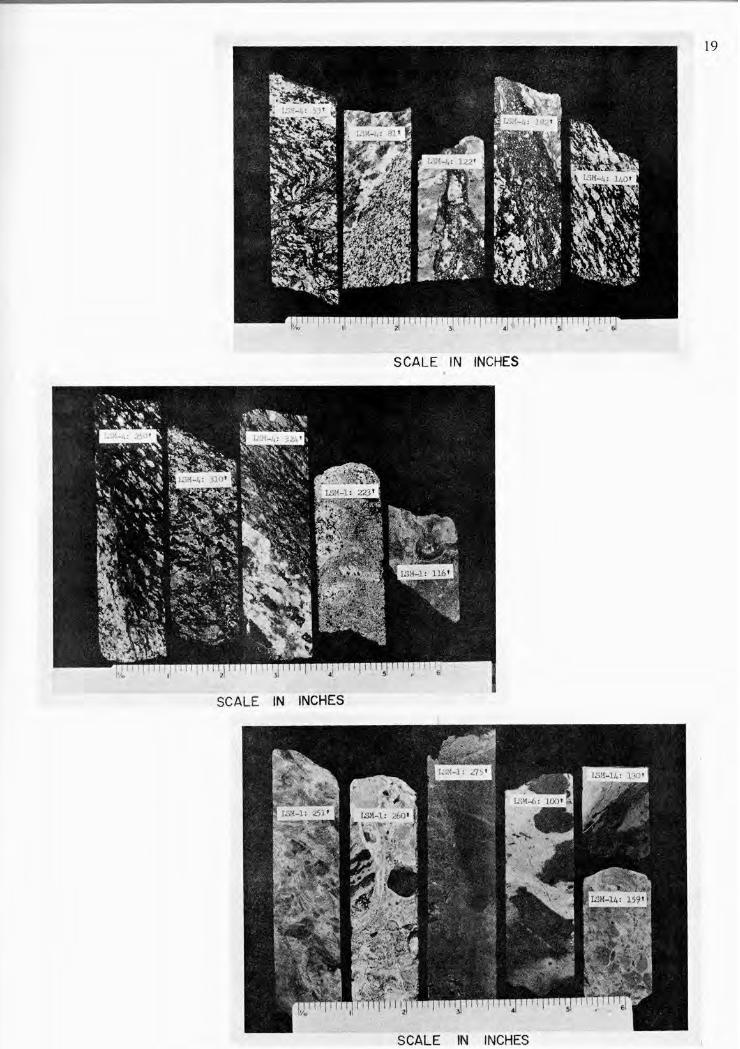
LSM-4: 53' LSM-4: 81' LSM-4:122'
LSM-4:182' LSM-4:140'
LSM4:2S0' LSM4:310' LSM4:324' LSM·I :223'
LSM·l:1l6'
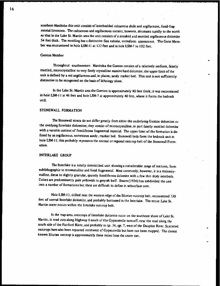
PLATE L ST. MARTIN SERIES • ALTERED GNEISS
- foliation in gneiss dist'Orted by intrusion of thin pseudotachylyte veinlet'S~ - fmer grained gneiss cut by pegmatite vein. - pseudotachylyte vein cutting pegmatite; larger fragments are from adjacent
walls. - pseudotachylyte vein with pegmatite to upper right, altered gneiss to left. - typical altered gneiss.
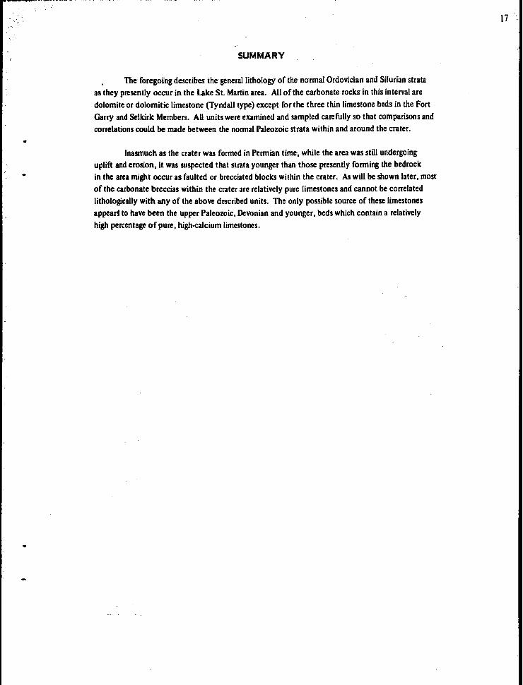
PLATE 2. ST. MARTIN SERIES - ALTERED GNEISS,
GRANITIC BRECCIA AND TRACHY ANDESITE.
- altered gneiss: more basic section of gneiss, cut by red iron oxide ve.inlets. - altered gneiss: foliation disrupted by thin pseudotachylyte vein. - altered gneiss cut by quam and red feldspar pegmatite vein. - polymict breccia; granitic fragments, surrounded by bleached zone, in micro-
breccia matrix.
- trachyandesite with large amygdale·like inclusion showing banded rim.
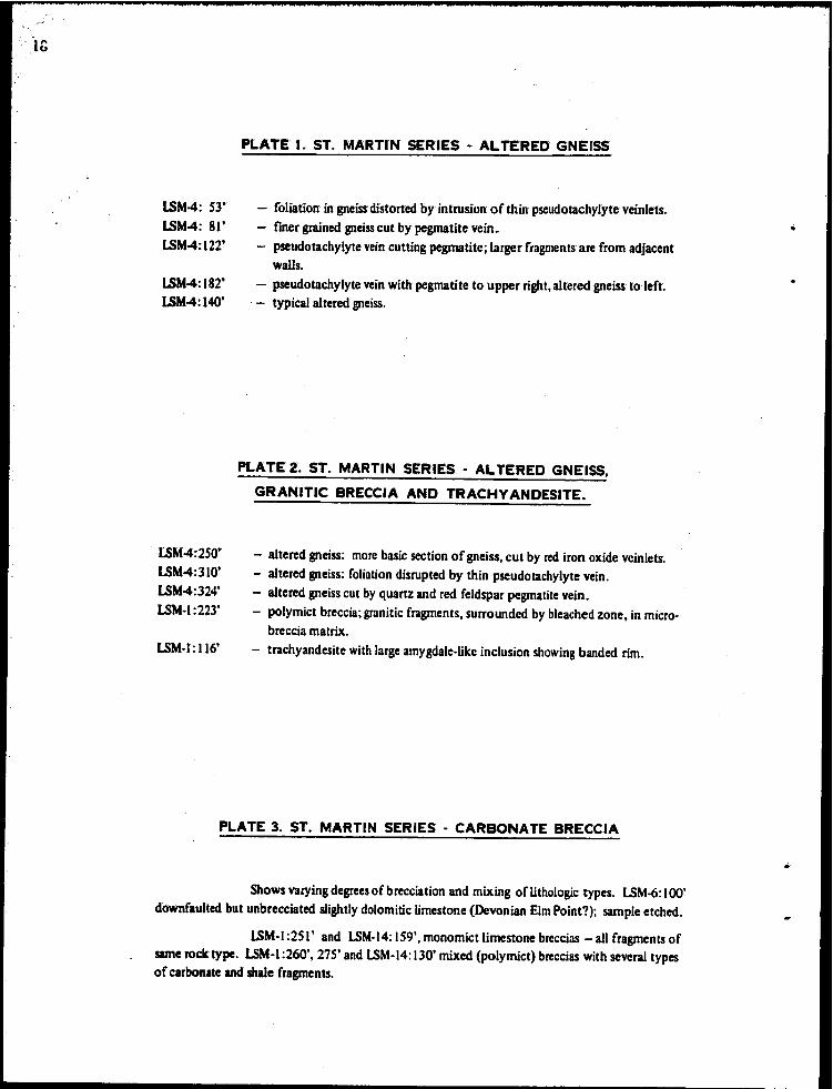
PLATE 3. ST. MARTIN SERIES· CARBONATE BRECCIA
Shows varying degrees of brecciation and mixing of lithologic types. LSM·6: 100' downfaulted but unbrecciated slightly dolomitic limestone (Devonian Elm Point?); sample etched.
ISM·I :251' and LSM·14: 159', monomict limestone breccias - all fragments of same rock type. LSM·I :260', 275' and LSM·14: 130' mixed (polymict) breccias with several types of carbonate and shale fragments.
20
B.G.:433'
B.G.:442'
B.G.:44S'
LSM~J~19S'
LSM·3:200'
LSM~3~223'
LSM~3:23S'
LSM·3:240'
PLATE 4. ST. MARTIN SERIES - POLYMICT BRECCIA
FROM BRALORNE GYPSUMVILLE 8-2c)'32-8WPM WELL
- granitic~ argiUaceous, and igneous' fragments in finely fragmental matrix; some vugs may have been fiUed originally with clayey or highly altered material; note evidence of banding I.S inchcsabove bottom edge of sample.
- extremely altered granitic inclusion with devitrified rim in breccia. - breccia containing relatively unaltered granitic fragments.
PLATE 5. ST. MARTIN SERIES - POLYMICT BRECCIA
- small pellets of varied lithology with iron oxide rim; highly altered. - fragments of aphanitic rock and carbonate rock in breccia matrix; note reduction
patches. - vesicular reddish aphanitic fragments in breccia matrix; light fragments are car
bonate rocks. - aphanitic igneous fragment with banded structure" enclosing granitic rock. - highly brecciated zone; distorted reddish brown aphanitic fragments enclose
mineral fragments.
PLATE 6. ST. MARTIN SERIES - MASSIVE TRACHYANDESITE
Abundant fine to coarse granitic inclusions. Small inclusions with clinopyroxene rims give mottled appearance. Faint banding around large fragment in LSM·3:28S'. Small fragments near top of LSM·3:280' are highly vesiculated.
.,.., ....
PLATE 7. AMARANTH FORMATION (1) - RED BEDS AND EVAPORITES
LSM·3:63.S' - gypsum with needre~liIce porphyroblilsts of anhydrite (stailted sample) LSM·3: ISO' - fUle banded red argillaceous silty dolomite. LSM·3: 162' ,167' - intraformational breccia of granite, dolomite and trachyandesite fragments
in dolomite sandstone. LSM·3:1S9'
LSM4:31S'
LSM4:64'
- sharp contact between Amaranth silty dolomite and breccia beds of the St. Martin series.
PLATE 8. ST', MARTIN SERIES - ALTERED GNEISS
- crossed nicols. Quartz with abundant fine inclusions and planar features (upper left) grading to clear quartz with a few decorated planar features and decreased birefringence, grading iIt turn to dark isotropic (thetomorphic) quartz and mosaic recrystallized quartz (bottom right).
PLATE 9. ST. MARTIN SERIES . ALTERED GNEISS
•
- crossed nicols. Recrystallized quartz in pegmatite vein. Coarse clear mosaic (bottom left) grading to fme concentrically banded mosaic quartz with brown glassy (black) bands, grading to clear fine mosaic quartz.
-,24
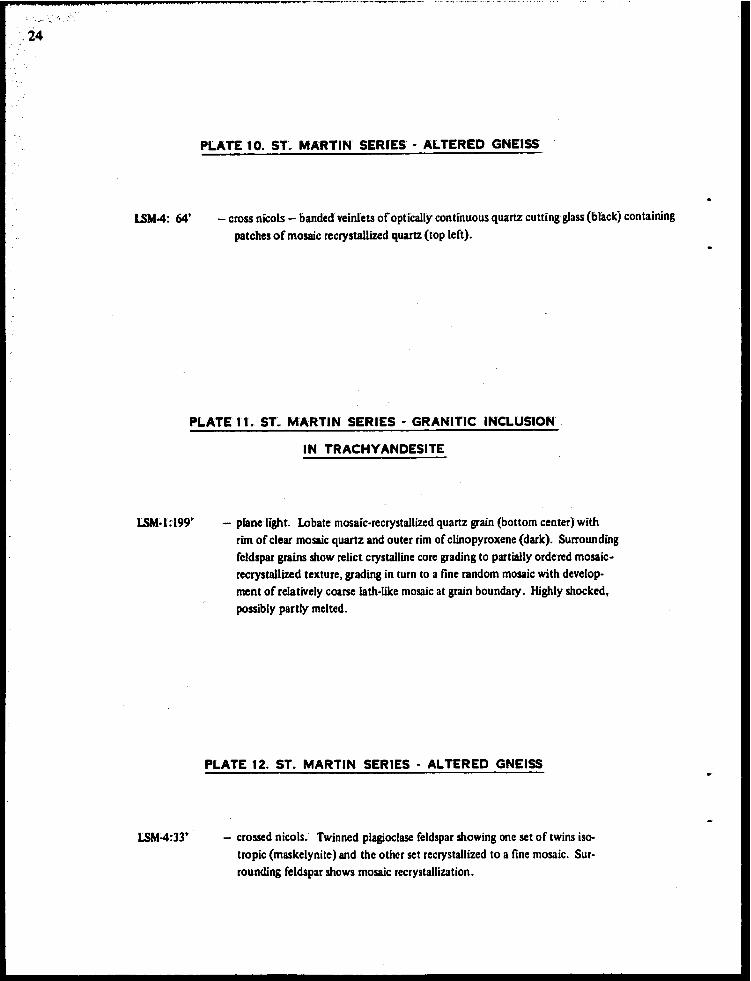
LSM4: 64'
PLATE to. ST. MARTIN SERIES - ALTERED GNEISS
- cross nicols - banded veinlets of optically continuous quartz cutting gJass(bbck) containing patches of mosaic recrystallized quartz (top left).
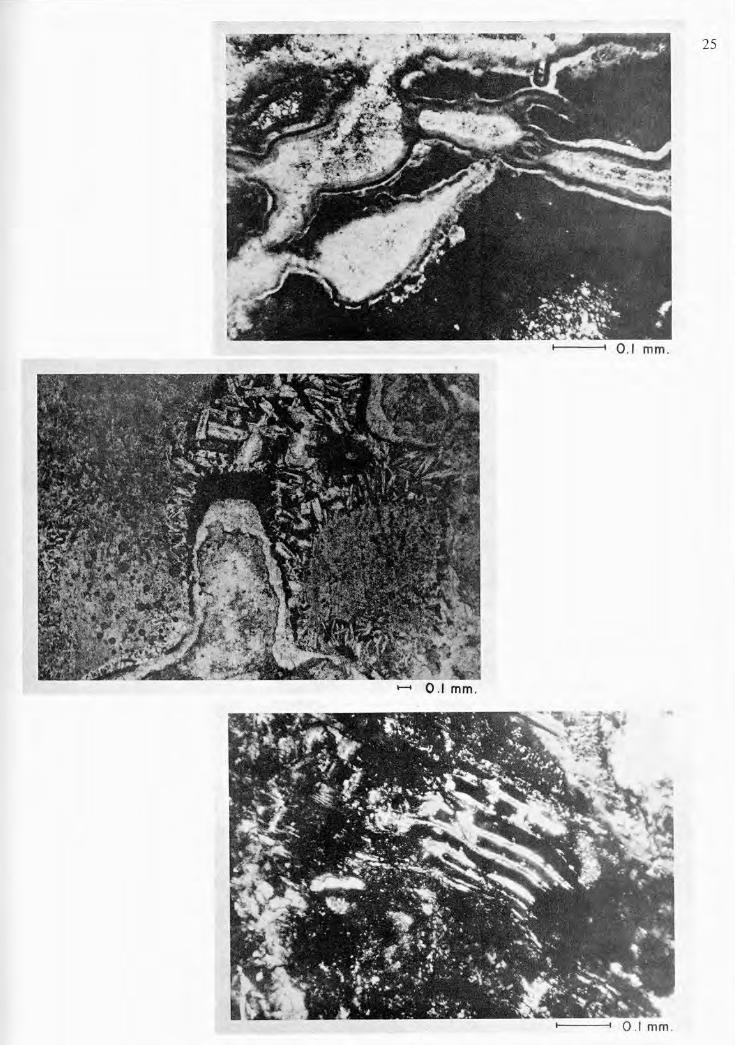
PLATE It. ST~ MARTIN SERIES - GRANITIC INCLUSION
IN TRACHY ANDESITE
LSM~1~r99'
LSM4:33'
- pbne light. Lobate mosaic·recrystallized quartz grain (bottom center) with rim of clear mosaic quartz and outer rim of clinopyroxene (dark). Surrounding feldspar grains show relict crystalline core grading to partially ordered mosaicrecrystallized texture, grading in turn to a fine random mosaic with development of relatively coarse lath·like mosaic at grain boundary. Highly shocked,_ possibly partly melted.
PLATE 12. ST. MARTIN SERIES - ALTERED GNEISS
- crossed nicols. Twinned plagioclase feldspar showing one set of twins isotropic (maskelynite) and the other set recrystallized tc a fine mosaic. Surrcunding feldspar shows mcsaic recrystallization.
.. -
-26
LSM4:200'
LSM4= 33'
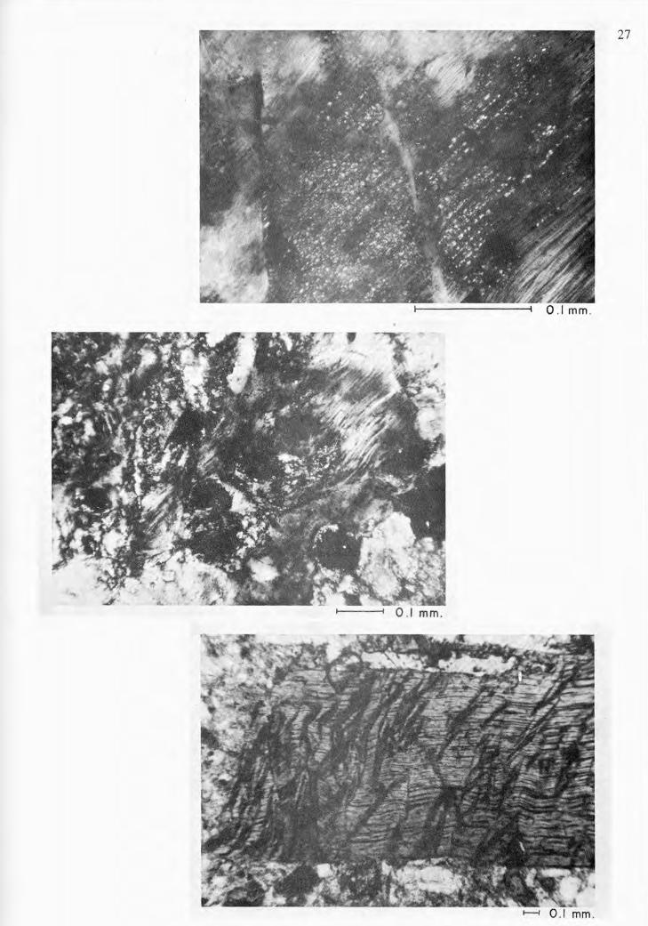
PLATE 13. ST~ MARTIN SERIES - ALTERED GNEISS
- crossed nicols. FeldSpar showing prominenf development of planar features~. patches' of decreased birefringence, and partial recrystallization to a flOe mosaic.
PLATE 14. ST. MARTIN SERIES - ALTERED GNEISS
- crossed nicols. Vesiculation structures in feldspar showing microcrystalline mosaic rims. Feldspars show extreme undulatory extinction and well-dev· eloped decorated planar features and small circular patches of flOe recrystallized mosaic.
PLATE 15. ST. MARTIN SERIES - "GRANITIC" BRECCIA
Bralorne GypsumviUe g·20·32·gWPM: 43S' - plane light. Biotite fragment showing prominent development of kink banding.
..
28
I----i 0 .1 mm .
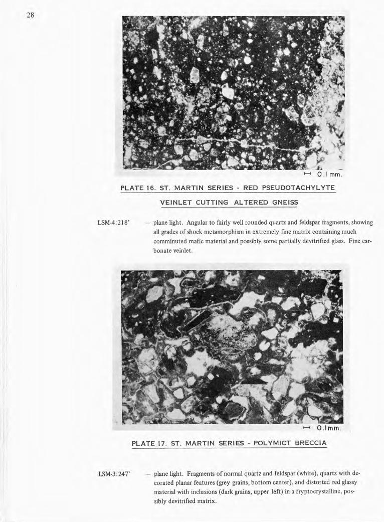
PLATE 16. ST. MARTIN SERIES - RED PSEUDOTACHYLYTE
LSM-4:218'
LSM-3:247'
VEINLET CUTTING ALTERED GNEISS
plane light. Angular to fairly well rounded quartz and feldspar fragments, showing
all grades of shock metamorphism in extremely fme matrix containing much
comminuted mafic material and possibly some partially devitrified glass. Fine car
bonate veinlet.
f---i 0 .1 mm.
PLATE 17. ST. MARTIN SERIES - POLYMICT BRECCIA
plane light . Fragments of normal quartz and feldspar (white), quartz with de
corated planar features (grey grains, bottom center), and distorted red glassy
material with inclusions (dark grains, upper left)in a cryptocrystalline, pos
sibly devitrified matrix.
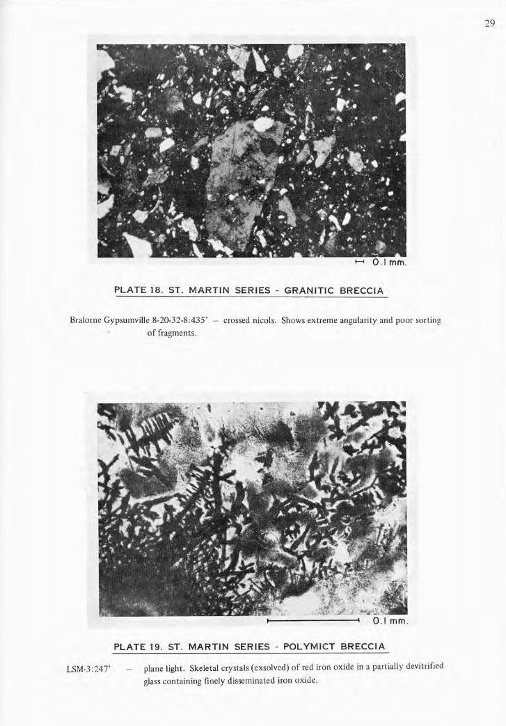
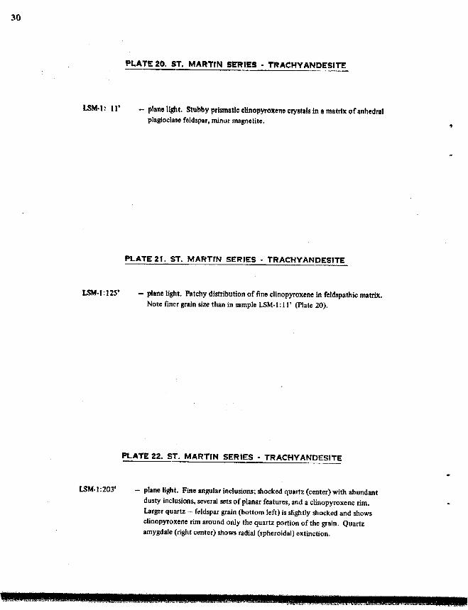
PLATE 18. ST. MARTIN SERIES - GRANITIC BRECCIA
Bralorne Gypsumville 8·20·32·8:435' - crossed nicols. Shows extreme angularity and poor sorting
of fragments.
LSM·3:24T
PLATE 19. ST. MARTIN SERIES - POLYMICT BRECCIA
plane light. Skeletal crystals (exsolved) of red iron oxide in a partially devitrified
glass containing finely disseminated iron oxide.
29
30
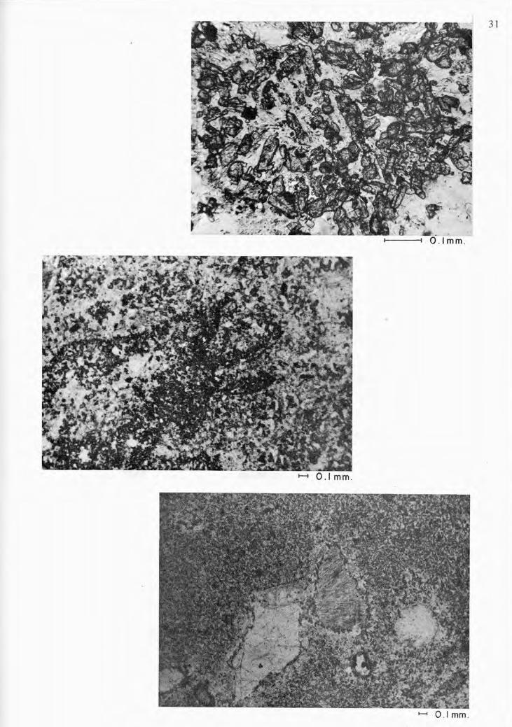
LSM·l: 11'
LSM·l : J 2S'
LSM·l :203'
PLATE 20. ST. MARTIN SERIES· TRACHYANDESfTE
- plane light. Stubby prismatic clinopyroxene cTYstals in a matrix of anhedral
plagioclase feldspar. minor magnetite.
PLATE 21. ST. MARTIN SERIES· TRACHYANDESITE
- plane light. Patchy distribution of fine clinopyroxene in feldspathic matrix.
Note finer grain size than in sample LSM·l: II' (plate 20).
PLATE 22. ST. MAR"fN SERIES· TRACHYANOE:S1TE
- plane light. Fine angular inclusions; shocked quartz (center) with abundant
dusty inclusions, several sets of planar features, and a clinopyroxene rim.
Larger quartz - feldspar grain (bottom left) is slightly shocked and shows clinopyroxene rim around only the quartz portion of the grain. Quartz
amygdale (right center) shows radial (spheroidal) extinction.
32
LSM-I:203 '
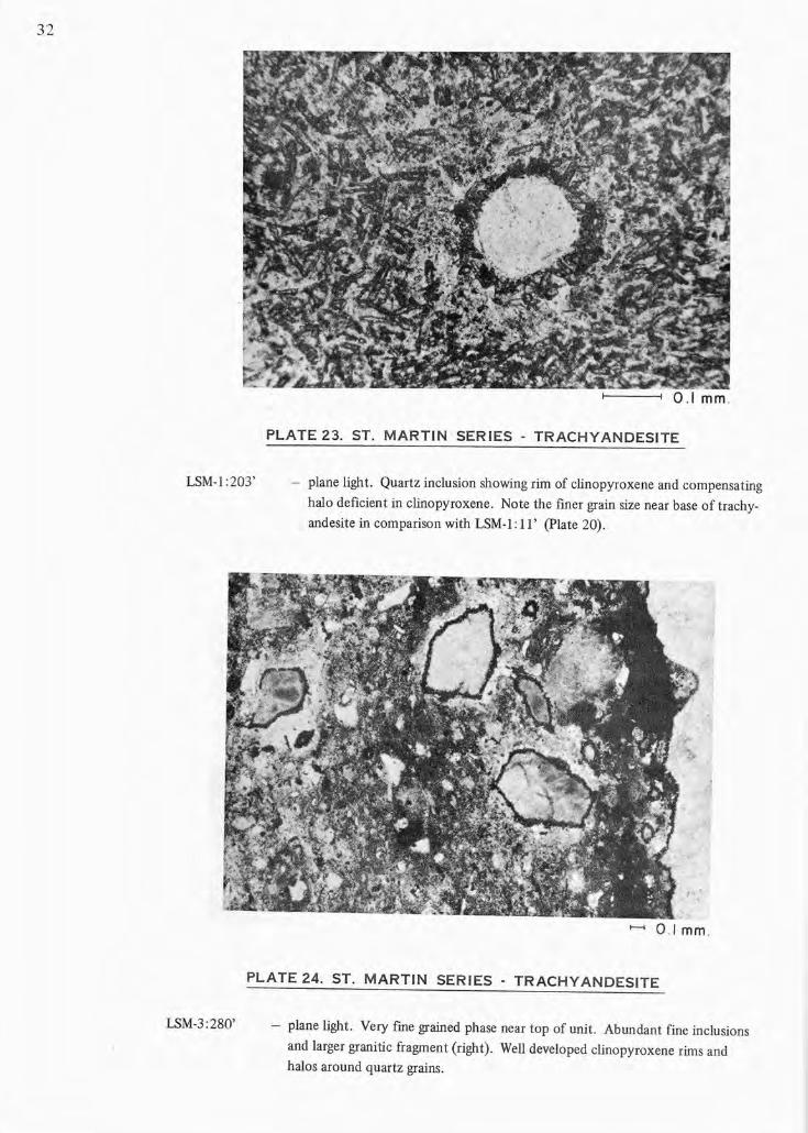
PLATE 23. ST. MARTIN SERIES - TRACHYANDESITE
- plane light. Quartz inclusion showing rim of clinopyroxene and compensating
halo deficient in clinopyroxene. Note the finer grain size near base of trachy
andesite in comparison with LSM-I: II' (plate 20).
......... 01 mm .
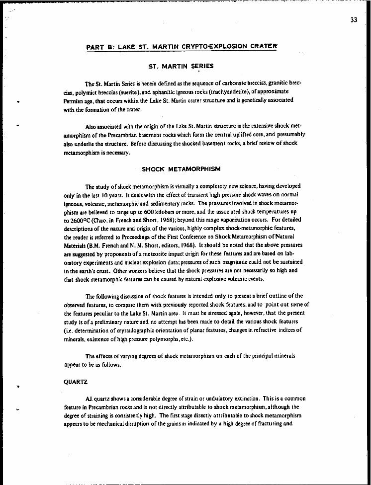
PLATE 24. ST. MARTIN SERIES - TRACHYANDESITE
LSM-3:280' - plane light. Very fme grained phase near top of unit. Abundant fine inclusions
and larger granitic fragment (right) . Well developed clinopyroxene rims and
halos around quartz grains.
'0 ..
PART B:' LAKE' ST., MARTIN CRYPTO-EXPL0510N CRATER
ST. MARTIN SERIES
The SL Martin Series is herein defined as the sequence of carbonate breccias,granicic brec
cias. polymict breccias (suevite). and aphanitic igneous rocks (trachyandesite), of approximate Permian age. that occurs within the Lake St. Martin crater structure and is genetically associated
with the formation of the crater.
Also associated with the origin of the Lake St. Martin structure is the extensive shock met· amorphism of the Precambrian basement rocks which form the central uplifted core, and presumably
also underlie the structure. Before discussing the shocked basement rocks, a brief review of shock
metamorphism is necessary.
SHOCK METAMORPHISM
The study of shock metamorphism is virtually a completely new science, having developed only in the last 10 years. It deals with the effect of transient high pressure shock waves on normal igneous, volcanic, metamorphic and sedimentary rocks. The pressures involved in shock metamorphism are believed to range up to 600 kilobars or more, and the associated shock temperature:; up to 26000 C (Chao, in French and Short, 1968); beyond this range vapori7.ation occurs. For detailed descriptions of the nature and origin of the various. highly complex shock·metamorphic features, the reader is referred to Proceedings of the First Conference on Shock Metamorphism of Natural Materials (8.M. French and N. M. Short. editors. 1968). It should be noted that the above pressures are suggested by proponents of a meteorite impact origin for these features and are based on lab· oratory experiments and nuclear explosion data; pressures of such magnitude could not be sustained in the earth's crust. Other workers believe that the shock pressures are not necessarily so high and that shock metamorphic features can be caused by natural explosive volcanic events.
The foUowing discussion of shock features is intended only to present a brief outline of the observed features, to compare them with previously reported shock features. and to point out some of the features peculiar to the Lake St. Martin area. It must be stressed again, however. that the present study is of a preliminary nature and no attempt has been made to detail the various shock features (i.e. determination of crystallographic orientation of planar features. changes in refractive indices of
minerals, existence of high pressure polymorphs, elc.).
The effects of varying degrees of shock metamorphism on each of the principal minerals appear to be as follows:
QUARTZ
All quartz shows a considerable degree of strain or undulatory extinction. This is a common feature in Precambrian rocks and is not directly attributable to shock metamorphism, although the degree of straining is consisten tly high. The first stage directly attributable to shock metamorphism appears to be mechanical disruption of the grains as indicated by a high degree of fracturing and
33
34
microbrecciation.
The next stage is the development of planar features; these are microscopic, fine" parallel, planar discontinuities resembling closely spaced cleavage traces. They can comprise a number of distinct sets (Plates 8,.23) oriented parallel to crystallographic directions in the crystal; in most instances they are "decorated" by minute inclusions. No orientation studies were made on the planar features, but Dence (personal communication) reports up to six sets per grain with the dominant orientations being of the omega (l013) and pi (l012) types. Where the development of planar features is most intense, the quartz commonly becomes highly clouded with minute inclusions (plates 8, 23), in part as decorations along the planar features; this quartz appears milky white in hand specimen.
The next stage appears to be an annealing of the quartz with a decrease in intensity of planar features and a "cleaning up" of the quartz, possibly due in part to aggregation of the fine decorations into coarser disseminated inclusions; expUlsion of impurities from the annealed area also seems to occur (plate 8). In places the inclusions remain aligned along annealed planar features. Coincident with the annealing is a marked decrease in birefringence with development of a nearly isotropic (thetomorphic) phase.
The next stage in shock metamorphism of quartz in the Lake St. Martin samples, involves a microcrystalline mosaic recrystallization of the quartz to a fine chert-like aggregate. Transition from cloudy quartz with planar features to annealed quartz with decreased birefringence to mosaic recrystallized quartz is shown in Plate 8. The mosaic quartz shows no evidence of planar features, and may be clear as in Plate 8. or may be markedly "dirty" with numerous fine inclusions. Development of mosaic recrystallization textures is one of the more common features noted in the shocked Lake St. Martin samples. especially for inclusions in the trachyandesite. but little reference to this stage of shock metamorphism has been noted in the literature. Oenee (personal communication) also has noted the mosaic recrystallization in these samples and has considered it to be a shock metamorphic effect.
The highest grade of recrystallization was noted in some of the shocked granitic inclusions in the trachyandesite (plate 11); this may result in part from the thermal effects of the surrounding trachyandesites. In these samples rims of clear quartz have been developed around mosaic recrystallized quartz grains (plate 11). In most cases the rims are also a mosaic quartz. but in a few instances rims of spheroidal quartz showing standing extinction crosses have been noted. These may possibly result from actual melting and recrystallization around grain boundaries.
Thetomorphic (isotropic) quartz is not common in the St. Martin rocks, and has not been noted as a specific stage in the shock metamorphic sequence. Where found it appears to be a medium grade shock feature preceding development of mosaic recrystallization. It seems probable that relatively high temperatures were maintained over a considerable period of time (in part due to the presence of thick trachyandesite) and largely prevented preservation of the metastable thetomorphic stage. The formation of thetomorphic glasses is believed to result from a solid-state disordering of the crystalline lattice rather than ar.tual melting.
0-
...
FELDSPAR
Feldspars follow the same general pattem of shock metamorphic features as quartz. The initial stage of shock is evidenced by mechanical disruption, in places well shown by distortion and microfaulting of twin lamellae, and development of pronounced strain extinction and kink banding. The next stage is the development of planar features which is somewhat less common in feldspar than in quartz and is accompanied by a less intense development of fine inclusions than noted in quartz (plate 13).
The next stage appears to be, once again, an annealing of the feldspar, accompanied by "cleaning up", loss of twinning and planar features and decrease in birefringence, grading to com· plete isotropism (i.e. development ofthetomorphic feldspar or maskelynite) (Plates 13, 14). [n some instances one set of plagioclase twins has become isotropic whereas the other appears nor· mal. One instance was noted where one set of twins was isotropic and the other had been recry· stallized to a fine mosaic (plate 12).
As in the case of quartz, and probably for the same reasons, thetomorphic plagioclase is not a major constituent of the shocked rocks at Lake SI. Martin, although it is more common than thetomorphic quartz, and is abundant in a few samples (Plate 13).
The next stage of shock appears to be mosaic recrystallization. Three stages of mosaic recrystallization have been noted. The first stage involves a mosaic recrystallization with partial retention of the gross optical continuity of the parent grain. A normal crystalline core (probably annealed) grades out to an area of mosaic recrystallization that shows gross extinction the same as the relict parent except that each of the small recrystallized units shows a slightly different orientation and extinction from the parent. This in turn may pass to a fine mosaic where no gross extinction characteristics are retained and complete disordering of the individual mosaic units has occurred (Plage I I). The final stage involves development of a relatively coarse recrystallized lath-like feldspar mosaic, probably reSUlting from actual melting and recrystallization (Plate II).
[t should be noted that the above stages in mosaic recrystallization are well developed only in the shocked granitic inclusions in trachyandesite. This suggests that these shock metamorphic features have been modified by a prolonged period of post·shock thermal metamorphism or annealing.
Also associated with mosaic recrystallization of the feldspars, in some samples, is the development of porous vesiculation structures (Plate 14); these are small features,les.~ than ~ millimeter in diameter, that appear to be developed only in the feldspar grains, and commonly show a rim of fine mosaic-recrystallized feldspar.
B[OTITE
The effects of shock metamorphism on ferromagnesian minerals differ considerably from the features described previously for quartz and feldspar. As pointed out by Chao (in French and Short, 1968) this is due to the different, more compact, atomic structure of the mafics which renders them less susceptible to pressure effects. The effect of the high temperatures associated with shock metamorphism therefore becomes the dominant factor.
35
36
The rust' stage ofmoclc in biotite once again appears to be mechanical disruption with dis" tortion and shredding of the grains and development of kink banding (plate 15). Increased shock temperatures apparently result in a degradation or decomposition of the biotite. and progressive gradation can be observed from a relatively normal biotite to a markedly reddish (Oxidized 1) biotite showing decreased pleochroism and possibly decreased birefringence (the deep coloration makes direct visual estimation of birefringence difficult). Still higher degree of shock results in an . increasingly opaque material which probably consists of a mixture of red iron oxide and glass (Chao. in French and Short. 1968) ..
AMPHIBOLE
All of the amphiboles in the shocked gneissic core show an extreme pleochroism •. from light brown to black; this is characteristic of basaltic or oxy-hornblende and appears to be a thermal metamorphic effect. (Oxy-hornblende has been produced experimentally from normal hornblende by heating to 8000C under Oxidizing conditions). Inasmuch as oxy·hornblendes are reo ported only from high temperature volcanic rocks. it seems reasonable to assume that the highly pleochroic nature of the hornblendes in the gneisses results from the thermal effects of shock meta .. morphism.
In addition to the strong pleochrOism. the amphiboles are highly fractured and in places develop rather coarse planar features similar to parting. At higher grades of shock the amphibole becomes progressively darker coloured. more reddish and more opaque. Pleochroism and birefringence also appear to decrease and at the highest stages of metamorphism the amphibole becomes completely opaque. As was susgested for the biotites. this appears to be due to a progressive decomposition of the amphibole probably with formation of a mixture of iron oxide and glass.
It should be noted that some of the features discussed above and attributed to or associated with shock metamorphism may not be the direct result of shock. In particular. development of the cloudy, dirty inclusions in the quartz and feldspar may reflect a later, possibly hydrothermal type of alteration, but nevertheless the extent of this alteration probably is directly related to the intensity of shock, lattice deformation, etc. Similarly the thermal annealing effect. especially for the shocked inclusions in the trachyandesite. results in a thermal overprint on the shock features. The net result is that the "shock metamorphic" effects herein described probably include. or have been modified by. thermal and possibly hydrothermal effects.
PSEUDOTACHYL YTE
Veinlets of red to brownish grey glass and devitrified glass. containing abundan t fine rock and mineral fragments cut the shocked gneiss core. The veinlets in places show flowage structure. and range in thickness from hairline stringers to veins several inches wide (Plates I. 2) These veinlets are similar in nature to pseudotachylyte veinlets reported from other crater structures. and are believed to result from brecciation. melting. and injection. associated with the extremely high pressures and temperatures developed during crater formation. The fragments within the veinlets are commonly monomineralic. angular. subangular. or subrounded and show all degrees of shock metamorphism. ranging from clear. undeformed crystals to mosaic recrystallized aggregates. Fragment size is
.-
•
•.
commonly less than 118 inch;.larger fragments, to ~. inch,. are rare and for the most part are locally
derived from the adjacent wall rock (Plate I). The matrix may consist of:
I) 2)
3)
4)
opaque material,. red in reflected light.
orange to red translucent (iron oxide·rich ?) glass.
patches of low birefringence recrystallized material (devitrified glass)
within red iron oxide rich material •
brecciated mineral fragments, dOminantly mafics with associated iron
oxide; the fragments range in size down to near the limit of microscopic
resolution.
The distinctive features of the veinlets are the micro breccia texture and the distinctive red
coloration due to the abundance of red iron oxide.
ALTERED GNEISS
Altered hematized, shock·metamorphosed hornblende·biotite granitic gneiss cut by pegmatite
is exposed in two drumlinoid outcrops in NWY.a sec. 27, tp. 32, rge. 8WPM, and NM4 sec. 34, tp. 32,
rge. 8WPM, situated in the central area of the lake St. Martin structure (Fig. 2); these outcrops pre
sumably are part of an uplifted core of Precambrian basement rocks. The gneissosity is weU-developed
and strikes 1400 • The gneiSS and pegmatites are intruded by veins of red to grey pseudotachylyte, em
placed at the time of crater formation. The whole outcrop has a strongly weathered appearance, but
this is caused not so much by weathering as by the presence of shock metamorphosed minerals (e.g.
maskelynitized feldspars, shocked opalescent quartz, and hematized mafic minerals); alteration due to
weathering is considered to be minimal. Despite the shock metamorphism and uplift of the Precam
brian rock, the gneissosity is apparently constant across the outcrops.
A 396-foot vertical drill hole, LSM4. was collared at the southeast end of the more southerly
outcrop, on the basis of a magnetic and electromagnetic anomaly reported by W. Zahynacz and C. D.
Anderson, University of Manitoba (personal communication); no mineralization that could account for
the anomaly was intersected. but additional drilling may be warranted.
In places. the core is closely fractured. and the gneiss has undergone deformation ranging from
mild to fairly intense. A core sample from LSM4 at 53 feet shows sharply contorted foliated rock with
pseudotachylyte veins cutting the folds (Plate I). Parts of the core have a slightly brecciated or crushed
texture. The dip of the gneissosity varies throughout the core, but averages approximately 45 degrees.
The gneiSS has a less altered. less fractured appearance in the lower 50 feet, with little evidence of hem
atization of mafic minerals.
A sample from 388 feet, free of pegmatitic and pseudotachylyte veins, was analyzed (Table 2.
Sample 8); this sample is judged to have a mafic mineral content exceeding that of most of the more
all~red core higher in the hole; additional chemical analyses are required to obtain the average com
position of the altered gneiss. However, on the basis of this one analysis, the average composition of
the gneiss probably is roughly comparable to the granitic breccia in the Bralorne well and to the tra
chyandesite.
37
IoU 00
TABLE 2 CHEMICAL ANALYSES OF SELECTED SAMPLES, ST. MARTIN SERIES.
SAMPLE NUMBER
~ 3 4 5 ~ 7 8 9 10
SiO~ 63.65 63.8 61.4Q 61.4 63.4 59.6$ 60.0 .54.6 1.l5 0.3
AI 203 14.0 IS.' 15.2 15.3 13.9 13.3 14.5 16.45 0.3 nil
Fe203 2.34 3.70 4.49 5.90 1.94 2.83 2.74 5.85 0.18 0.95
FeO 1.87 1.23 1.42 0.45 1.10 0.64 2.10 2.70 0.20 0.41
Cao 5.13 436 1.80 2.23 1.58 1.90 2.33 4.49 54.0 31.1
MgO 2.90 2.20 3.69 1.70 5.64 5.86 3.87 3.90 J.JO 20.7 Na20 4.4Q 4.40 4.54 2.69 4.06 4.30 3.65 5.01 nil nil
K20 3.42 2.88 4.25 4.24 2.70 3.00 3.47 2.75 0.07 0.10 Ti02 0.41 0.44 0.36 0.46 0.26 0.29 0.48 0.67 om nil P20 5 0.13 0.13 0.19 0.16 0.03 0.12 0.22 0.28 0.01 nil MnO 0.06 0.06 0.05 0.05 0.03 0.05 0.07 0.16 trace 0.Q2
"20 1.14 1.14 2.10 4.96 4.48 6.91 3.90 2.05 0.79 0.52
CO2 0.23 0.24 0.25 0.16 0.39 1.06 2.88 0.63 42.45 45.7
Total 99.68 99.70 99.74 99.70 99.51 99.91 100.21 99.54 100.26 99.8Q
I) Trachyandesite: LSM·I: combined core fragments from 22 feet and 135 feet. 2) Trachyandesite: LSM·3: core fragments from 274 feet and 276 feet. 3) Trachyandesite: Dralorne GypsumviUe 8·20·32·8WPM; from bit sample 1055 feet. 4) Pseudotachylyte veinlet cutting altered gneiss: LSM-4 at IS feet. 5) Granitic breccia: LSM·I at 219 feet. 6) Polymict breccia: LSM·3 at 219 feet and 222 feet. 7) Granitic breccia: Dralorne Gypsumville 8·20·32·8WPM; core fragments from 430 feet to 440 feet. 8) Altered gneiss: LSM-4 at 388 feet. 9) Carbonate breccia: LSM·I at 239 feet.
10) Carbonate breccia: LSM-6 at 194 feet to' 220 feet, some pyrite.
0, '.
•
•.
Veins and pat'Ches of pegmatitic material consisting of salmon-coloured feldspar and milky white opalescent quartz intrude the gneiss. Six veins, varying from 2 to 4 feet thick are present in the upper 300 feet of core; only a small amount of pegmatite is present in the lower 99 feet 0 f core. In places, graphic intergrowth of cuneiform quartz in potash feldspar is present in the pegmatite. Also present in the core are short intervals of finer grained granitic material.
The pseudotachylyte veinlets are either medium red in colour, or have a central greyish brown area with red borders. The veinlets are most abundant in the upper 300 feet of core. The upper 2 feet of core recovered, from 15 to I7 feet, is entirely pseudotachylyte-type material, consis~ ling of a breccia matrix containing rock fragments, fragments of red aphanitic material, and abundant white chalky inclusions (shocked, recrystallized quartz, and feldspars).
An analysis ofa pseudotachylyte veinlet from LSM4 : 15 feet is listed in Table 2, sample 4;.
the analysis is fairly similar to that of the fragments of aphanitic igneous rock at 1055 feet in the Bralorne well (Table 2, sample 3), except for lower magnesia and soda, and higher H20 content.
Petrographic examination of the altered gneiss, pegmatite, and pseudotachylyte veins showed abundant evidence of shock metamorphic features and of deformation effects. The preliminary studies indicate that the intensity of the shock causing these features varies from weak to extreme at irregular intervals throughout the core, but with an overall decrease in intensity with depth.
Feldspar grains exhibit a complete range of shock metamorphic features. Twin lameUae within the grains are either offset by small fractures, or are slightly curved, plasticly contorted, or highly distorted; highly fractured or shattered grains are present also. Recrystallization along grain boundaries occurs in places. Development of several sets of planar features, and of isotropic (thetomorphic) feldspar, and mosaic recrystallization of the feldspar is present in the same sections. Vesiculation structures, with a thin rim of microcrystalline material, occur in relative abundance in the upper part of the core; in some vesiculated grains, the feldspar twinning is almost completely destroyed, and the grain has a mosaic recrystallized texture. An abundant white alteration (doudiness) pervades all feldspar grains in the surface and near surface portions; this cloudiness decreases with depth.
Maskelynite is definitely more abundant in the lower part of the core, and mosaic recrystallization is less common indicating a lower grade of shock metamorphism. Associated with this change is an increase in the OcCUrrence of planar features in the feldspar; discrete grains of sericite are scattered throughout the feldspar in this section.
Quartz grains in the upper part of the core are either highly clouded with inclusions, generally showing a brownish colour in plane light, or are highly strained, clean, with planar features, or show extensive development of patches and veinlets of recrystallized material. These grains, as discussed in the previous section on shock metamorphism, are probably indicative of a moderate to high grade of shock. Highly strained and fractured quartz grains, showing multiple sets of planar features, are abundant in the lower part of the core; these grains also show a brownish cloudy alteration, consisting of small inclusions oriented along planar features.
The mafic minerals also show various stages of degradation, believed to be a shock metamorphic effect. In the upper part of the core the mafies are to a high degree obscured by disseminated red iron oxide, but crystalline grains of biotite and hornblende, with decreased pleochroism and birefringence,
39
40
are diScernible. [n one of the most highly shocked sections, recognizable biotite and hornblende are almost completely absent and' are represented by pseudomorphic patches of red iron oxide (possibly glass with dissolved iron oxide) enclosing some magnetite gr3inS. In the least shocked sections of the gneiss, hornblende shows extreme pleochroism and other optical properties of oxy-hornblende, and some biotite grains show kink banding; red iron oxide is generally associated with the mafics. According to Deer, Howie and Zussman (1963) oxy-hornblende is indicative of high temperature conditions of formation.
Thin sections of the quartz-feldspar pegmatite veinlets show interesting changes in selected thin sections at various depths. A thin section from an outcrop sample shows cuneiform intergrowth of quartz and feldspar, devitrified glass, and much recrystallization. A pegmatite vein at 64 feet contains an abundance of (quartz '?) glass, with "peninsulas" of crystalline material projecting into the glassy areas (Plate 10). The quartz is recrystallized, exhibiting line concentric banding of partly glassy material around cores of mosaically crystallized quartz (Plate 9). This probably represents melted, flowed and partially recrystallized quartz ('?) glass (Iechatelierite). At 105 feet, abundant recrystallization and vesiculation structures are present, and evidence of a high degree of deformation is abundant. Multiple sets of planar features are present in the feldspars, many of them being bent and kinked. The quartz has been recrystallized, and contains abundant inclusions. At 236 feet, the quartz is in part clear, in part clouded with minute inclusions. Planar features are abundant; microcline is fractured and kinked. Much less recrystallization is present than at 105 feet. In the above 3 pegmatites, calcite veinle ts are present.
In a pegrnati te at 318 feet, deformation is not as noticeable as in the above sections. Quartz, containing abundant brown decorations, many recrystallized to hematite, shows a "crackle-type" of fracture. Sets of multiple planar features in both the quartz and feldspar are almost continuous throughout the slide, which shows the highest degree of development of planar features seen within the St. Manin Series.
The general characteristics of the pseudotachylyte veinlets have been described previously. The veinlets have the appearance of line breccia fragments enclosed in a continuous matrix composed predominantly of red iron oxide (pI age 16). The fragments show all degrees of shock metamorphism, from slightly distorted grains, to patches of melted and recrystaUized quartz and feldspar. Some veinlets contain larger rock fragments of the altered gneiss and pegmatite, up to ~-inch across, that appear to be derived from the adjacent rock and have not been appreciably altered.
From the selected samples studied, it is evident that the grade of shock metamorphism is variable thrQllghout the core, probably caused by variations in shock pressures and type of material. Melting and recrystallization textures occur in strongly shocked sections between less intensely shocked zones. The degree of shock metamorphism can vary rapidly, within an interval of a few feet. In general, however, an overall decrease in the peak intensities can be noted with depth, particularly below the 3OO-foot level.
•
CARBONATE BRECCIAS
The rocks included in the "carbonate breccias" represent disturbed Paleozoic strata occurring within the crater and could, at least in part, be considered as belonging to the Paleozoic sequence. How·· ever, because of the generally extensive faulting, brecciation,. mixing, and uncertainty as to age, aU of the carbonate rocks within the crater are herein assigned to the St. Martin Series .
Three core holes have intersected faulted and brecciated carbonate rocks within the crater rim; these are holes LSM-2, LSM-6, and LSM-14 (Fig. 2). According to the present interpretation, the reported limestone outcrop in sec. 25, tp. 33, rge. 8WPM is also within the crater; this occurrence has not been examined in the present study.
Marked differences in degree of deformation are evident in the above three holes. rn LSM-I, located immediately within the crater rim, the carbonate breccias occur at a depth of 225 feet and are overlain by, and in the upper 10 feet interlayered with, "granitic" breccias, which are in tum overlain by a thick sequence of "trachyandesites" (Fig. 4). The carbonates are highly brecciated throughout, but despite the high degree of brecciation there is, for the most part. no great degree of mixing of fragments of markedly different lithologic types, so that a general lithologic sequence can be determined. The carbonates appear to be "tectonically" brecciated strata rather than a sedimentary or transported breccia. Hole LSM-I cored 71 feet of carbonate breccia and bottomed at 296 feet while still in carbonate breccia beds. No fragments of granite or trachyandesite were seen in the carbonate breccia zone except for the previously noted interbeds of granitic breccia in the top 10 feet of the interval.
UtholOgically, the breccias are predominantly high calcium limestones, mostly microcrystalline, dense, and sparsely fossiliferous; colours are variable but predominantly light grey-buff with some medium to dark grey and some reddish grey. prominently mottled. Argillaceous limestone and calcareous shale intervals are common in the lower part of the cored section, and intervals of dolomite breccia are present near the base. Chemical analysis of the high-calcium limestones (Table 2. Sample 9) shows some of the purest limestones yet reported for Manitoba. No features directly at tributable to shock metamorphism were noted. other than the intense brecciation.
Virtually none of the rock types encountered in the breccia could be correlated lithologically with any of the previously described Ordovician and Silurian strata from the surrounding area. In southwestern Manitoba. high-calcium limestones and dolomitic shales are limited almost entirely to Devonian or younger Paleozoic strata (e.g. Elm Point. Dawson Bay. Souris River. Ashern). so it is postulated that the carbonate breccia beds represent totally or in large part. downfaulted and brec· ciated Devonian or younger Paleozoic strata. These strata. presumably present in the area at the time of crater formation and incorporated into the crater structure. subsequently have been removed from the surrounding area by post-crater erosion. Microfossil studies are being carried out on these strata ~o see if the proposed Devonian or younger age is correct.
Hole LSM-14 is located approximately the same distance from the center of the crater as the previous hole. but on the opposite side of the crater rim. The carbonate breccias in hole LSM-14 are not overlain by trachyandesite and granitic breccia, as in hole LSM-l. and the degree of brecciation
41
42
is considerably less. The breccia beds were encountered beneath a 28·fool cover of glaCial till, and a 171·foot section was cored; because of poor ground conditions the hole had to be abandoned at a
depth of 199 feet while still in breccia beds.
Most of the core consists of a highly fractured rock with the fractures sealed for the most part by crystalline calcite. In some intervals beds have been entirely brecciated but fragments and matrix are of the same composition (I.e. a "crackle" or mosaic breccia) (plate 2, LSM·14: 159'); still other intervals, notably the more shaly beds, are highly brecciated and contain a variety of car;. bonate types (polymict breccia) (Plate 2, LSM·14: 130'). High-calcium, dense to fossil·fragmental limestones once again constitute the largest part of the section, although some dense to saccharoidal dolomite intervals are present as well as several intervals of calcareous and dolomitic shales. Color is predominantly light buff but some intervals show reddish to yellowish and purplish mottling and streaking (possibly due to oxidizing solutions circulating through the highly fractured rock). Where evidence of bedding was preserved, dips of 300 to 600 were noted.
Here again, most of the rock types encountered in the breccia in LSM·14 are not lithologically correlatable with the previously described lower Paleozoic strata of the surrounding area; they are believed to represent downfaulted Devonian or younger Paleozoic strata.
Core hole LSM·6 is located immediately inside the southwestern rim of the crater, approximately the same distance from the center of the crater as the two previously described holes (i.e. 612 miles). Carbonate strata encountered in this hole differ considerably from the previously described rocks in that, for the most part, there is little evidence of bn:cciation or fracturing, and fme undisturbed essentially horizontal lamination is evident in the upper part of the core. However. only 8 feet of badly broken and mixed core was obtained from the bottom 75·foot interval in this hole, and the lithologic types in this zone were quite varied suggesting that this part of the section probably is brecciated.
lithologically, the upper part of the hole, from 50 to 157 feet consists of an upper 2a-foot interval of horizontally interbedded and laminated limestone and dolomite. Below this is an 83·foot section of uniform, medium yellowish brown to pale yellowish buff, mottled, micro-crystalline to very finely crystalline limestone with abundant scattered fossil fragments (biomicrite). The darker patches are compact and dense; the lighter patches are slightly more granular and in places show incipient dolomitization - a dusting of fine dolomite drystals. One short interval (at \00 feet) shows a high
. degree of dolomitization of the lighter patches, but in general the 87·foot section consists of a rela· tively pure high-calcium limestone (see Analyses, Part C). Although the mottling, at first glance, is quite similar to the mottled dolomitic limestones of the Red River Formation. the dolomite content is very much lower, and the mottling pattern is reversed; in the Red River beds, the darker mottles are the dolomitized areas.
This section of mottled limestone cannot be correlated with any of the previously described lower Paleozoic strata, but it is lithologically identical to, and believed to be correlated with, the Middle Devonian Elm Point Formation. The 83·foot section of limestone is thicker than any known section of Elm Point strata in the outcrop belt, where the maximum thickness of 44 feet is recorded in the Steep Rock Quarry, twenty·four miles southwest of Gypsumville. At Steep Rock, however. the upper part
"4$ ____ w ..... 'M ........... P .... ---__ ~_r_.._....,.......,.. ..• ~~., -~~ .
,.,
of the Elm Pornt has' been eroded. The relatively undisturbed nature of the Elm Point (?) strata in the crater sugests that they comprise part of a large downdropped fault block immediately within the crater rim. The elevation of the fault block, assuming the Elm Point correlation is correct, is approx· imately 25()'300 feet below the extrapolated regional elevation of the Elm Point.
Below the uniform limestone interval is a 4·foot section consisting of dolomite" calcareous dolOmite, and highly fractured limestone with prominent vuggy solution cavities along the fractures;. this possibly indicates proximity to the base of the main fault block. Included in the mixed core be· low this are several pieces of red argillaceous dolomite that might possibly represent the basal Devonean Ashern Formation; the other fragments were not lithologically distinctive, but some of the ,pieces of
buff dolomite are similar to the Silurian Interlake dolomites.
One other possible occurrence of carbonate breccia within the crater is the outcrop reported in sec. 25, tp. 33, rge. 8WPM; the position of this outcrop in relation to the center of the crater is al· most identical to the three previously described occurrences. Wet weather and difficult access have so far prevented examination of this outcrop.
From the limited data presently available, it seems probable that the occurrence of carbonate breccias is limited to a narrow belt immediately within the crater rim.
POL YMICT BRECCIAS
IntervalS of breccias were recovered from three drill holes within the Lake St. Martin crater structure. Ught purplish grey breccia with predominantly granitic fragments is present from a depth of 214 to 225 feet below the trachyandesite in hole LSM·1. Breccia of diverse lithology is present from 189 feet to approximately 250 feet in LSM·3, below the Amaranth (?) Red Beds and above trachyandesite. The thickest breccia section is present from 170 to 1042 feet in the Bralorne Gypsum· ville 8·3().32·8WPM weD.
LSM·l: 214 to 225 feet.
The base of the purplish trachyandesite is marked by a sharp contact at an angle of 600 to the axis of the core, underlain by a ~·inch mixed zone of calcite, quartz, clay minerals, and mafics, and a 2·inch zone of 60 per cent sharply angular reddish brown veSicular igneous rock fragments in a matrix of crystalline calcite.
From 214 to 225 feet, the rock is a breccia of fairly well·rounded to sub·rounded Precambrian granitic fragments enclosed in a light purplish.grey matrix consisting of fine angular grains uf feldspars, quartz, and mafic minerals. The matrix in the area surrounding some of the fragments has been bleached to a light greenish'grey colour. No evidence of sorting or stratification was noted.
Five larger fragments of granitic material, ranging from 1 ~ inches to 2 feet in diameter, were cored. In the largest inclusion feldspar grains show a slightly shattered effect, and have salmon-coloured cores; the inclusion is cut by a network of calcite veinlets. Alteration products include red iron oxide, chlorite, and a green waxy material.
43
, 44
•• 4# ¥4M'
Tne matrix contains' granitic fragments grading down to the' size' ofthe larger monomineralic grains that form the major constituent of the matrix; the remainder of the matrix is a micro-breccia. A few fragments of soft, cream-coloured waxy material up to ~-inch across and with a rim of red oxide are present near the base.
The upper 10 feet of the underlying carbonate breccia are cut by thin zones of mixed breccias, consisting of fragments of granitic and carbonate rock and red shaly material in a matrix similar to that of the breccias above, but cut by calcite veinlets. The contacts between the mixed breccia and the carbonate breccia are well-defined, but highly irregular. A light brownish to red aphanitic vein has intruded the breccia in the zone at 227 feet.
The breccia in this hole" close to the rim of the structure, has a filirly uniform lithology and is generally similar to the breccia in the Bralome well. An analysis of the breccia matrix (free oflarge inclusions) from 219 feet is listed in Table 2, Sample 5.
LSM·3: 189 to 265 feet
Reddish-brown breccia of complex lithology is present overlying trachyandesite and under· lying Red Beds. Considerable vertical variation in lithology is evident. Red to purple aphanitic igneous fragments. in part contorted and showing fine banding, characterize the lower part of the core; granitic fragments, some with rims of purple, banded aphanitic material. are present also. An upward increase in the amount ofa matrix composed of fine breccia fragments and c1ay·like material is evident. Matrix is predominant in the upper part of the section. The percentage of carbonate fragments also increases upwards. A zone of iron-oxide-rimmed grains in a clayey matrix occurs in the upper part, overlain by a greenish-grey weathered zone.
In the lower part of the core from 265 to 231 feet, only 16 feet of core was recovered. The lowermost fragment is a vesicular reddish brown aphanitic rock, possibly representing the top of the trachyandesite body. As 3 feet of breccia core was recovered between 255 and 265 feet, the top of the flow lies between 258 and 265 feet.
The lower section of the breccia is characterized by an abundance of reddish brown and purple aphanitic igneous fragments, containing numerous inclusions of small angular mineral fragments; in places the igneous fragments are vesicular. The frogments show much plastic distortion and banding. Several types of gronitic fragments olso are present, including highly altered fine- grained granitic rocks with hematized mafies. and fragments, probably highly shocked, and in part vesiculated. containing segmented clots of salmon feldspars, bluish translucent quartz, and patches of greenish mafics. Some granitic fragments are rimmed with reddish aphanitic igneous material, from 1/8-to Iiinch in width, that shows a concentric banded structure; granitic fragments occur as inclusions up to l·inch in diameter within larger fragments of red aphanitic igneous material.
The breccia matrix consists of comminuted red aphanitic igneous material. fmc angular to rounded quartz grains, and abundant white to green clayey material. This section of the breccia is fairly well consolidated.
From 231 to' 191 feet,. the breccia zone is greenish grey to reddish brown;. scattered light' grey' reduction patches cut across fragment boundaries. Angular to rounded carbonate fragments •. up to ~-inch across. increase upwards in abundance in the upper 30 feet; the fragments are discoloured along their edges, rimmed by a thin layer of red iron oxide, or are surrounded by a reaction halo in the matrix. Some fragments of red aphanitic rock are highly altered to a soft red and grey clayey product. A few well rounded and' frosted quartz grains. possibly derived from the Winnipeg sandstone. occur in the
matrix.
The rock from 188 (0 198 feet (5 feet recovered) is comparatively' fine grained •. consisting of
rounded lI8·inch to 3/ r6-inch grains of carbonate, granitiC. and aphanitic igneous rocks,. quartz grains',. and soft clay like material, commonly rimmed with red iron oxide. Abundant finely banded hollow tubes and globules of a soft green chlorite-like mineral occur either as rounded aggregates of globules or disseminated in the matrix. This section is soft. poorly consolidated and has a highly altered appear
ance.
The upper two feet of the breccia is weathered (0 a light greenish grey colour. The breccia is
insharp horizontal contact with the overlying silty, shaly Red Beds.
In thin section, the "red aphanitic igneous fragments" show a number of variations in matrix
characteristics suggestive of varying degrees of vitrification, or devitrification:
I) an opaque matrix probably consisting in large part of iron oxide (red in reflected light) encloses generally angular to subangular grains, pre· dominantly of quartz and feldspar; these grains vary from fresh·looking unaltered grains, to grains showing all stages of shock metamorphism (planar features, cloudiness,low birefringence, recrystallization).
2) some fragments have a translucent. glassy (isotropic) central area, with inclusions similar to the above; the fragments have an outer rim of opaque iron oxide (red in reflected light). In some grains. the central area has low birefringence (partly devitrified glass?).
3) some fragments have an opaque iron oxide·rich rim, enclosing a ~entral translucent glassy to cryptocrystalline area in which exsolved dendritic red iron oxide crystals occur (see Plate 19).
The matrix is a cryptocrystalline aggregate, that appears white in reflected light, and contains quartz and feldspar grains that vary from unaltered to highly shocked and recrystallized (plate 17). In the lower part of the core the grains are surrounded by narrow rims of microcrystalline material.
Bralorne Gypsumville 8·20·32·8WPM
Breccia is present below Red Beds from a depth of 170 to 1042 feet. Core of the breccia was obtained from 431 to 454 feet (19.5 feet recovered) and of granitic rock from \042 to \055 feet (6 feet recovered); chip samples were recovered from the remainder of the interval. In addition. fragments of trachyandesite were recovered from the drill bit at a depth of lOSS feet. and are believed to represent
rock in place.
45
46
In'general the rock consists of a "vuggy" greenish grey to light purplish grey fine breccia matrix containing scattered large angular to rounded fragments, predominantly of granitic composition but also with numerous fragments of greenish to purplish aphanitic igneous (?) rock and soft grey clay·like: inclusions that have in part been washed out of the core and have contributed to the wggy nature of the breccia (plate 4). The fragments range from less than 1/8 inch to 8 inches in diameter; it is possible that the 6 feet of granitic rock recovered from 1042 to 1055 feet is a breccia fragment. The granitic fragments range from fresh unaltered in appearance to highly altered (in part weathered ?) and shock metamorphosed. One large granitic fragment at 442 feet shows an aphanitic rim up to ~ inch thick, probably of devitrified glass containing fine fragments of quartz, feldspar and mafic minerals. Dence (personal communication) reported that one of the inclusions of granitic gneiss shows features of moderate shock metamorphic grade.
The matrix of the breccia consists of angular quartz, feldspar and mafic mineral grains grading from I/S·inch down to fine silt and clay size (plate 18). Except for one instance of poorly· defined banding at an angle of approximately 450 to the core (Plate 4, Sample BG 433 ') bedding or stratification is not evident.
Petrographic examination of the breccia indicated the majority of the smaller fragments in tfiematrix are generally fresh, angular grains of quartz, feldspar, biotite, hornblende, and iron oxides. In some thin sections shock metamorphic features are present in these smalh:r fragments; quartz and feldspar with planar features, kinked biotite, and maskelynite were observed. The major part of the matrix appears to be an extremely fine grained mixture of similar composition to that of the fragments, although much of it is so fine grained that positive mineral identification is not possible.
Thin sections of the larger granitic fragments indicate a moderate to high degree of shock metamorphism (plagioclase with distorted or fractured twin lamellae, partial maskelynitization of plagioclase,and planar features in feldspars and quartz). At 440.5 feet, a ~·inch fragment of devitri· fled glass contains vesicles with banded rims and acicular crystals in radial orientation.
An analysis of the breccia matrix, free of large inclusions, from selected pieces between 430 and 440 feet, is listed in Table 2, Sample 7.
In the chip samples from 970 to 1042 feet, two distinctive types of fragments are present mixed with the predominantly granitic fragmental matrix; broken fragments of purplish aphanitic rock, somewhat similar to the trachyandesite in LSM·I and LSM·3, are present, as well as discrete spheroidal grains up to l/8·inch diameter of black obsidian·like glass. The glass is packed with dust· like inclusions, but shows no sign of devitrification. The presence of this glass was one llf the first· noted features of the lake St. Martin structure to indicate that the structure was a relatively young post·Precambrian feature; to the writers' knowledge no occurrences of undevitrified glass older than Carboniferous have been reported.
The 6 feet (If core recovered from 1042 to 1055 feet are of weakly to moderately shocked granitic gneiss; from evidence available, it cannot be determined whether the rock represents base· ment material more or less in place, or a large inclusion in the breccia; as noted below, some trachy·
andesite material is present' at 1055 feet'. The gneiss shows many features caused by a low grade' shock metamorphism: planar features in quartz and feldspar. kinked biotite" fractured hornblende. many fractured and faulted grains, and kinked feldspar. Feldspar grains show abundant inclusions, and patches of sericite near grain boundaries; zoned feldspars and micropegmatite are present.
APHANITIC IGNEOUS ROCKS - TRACHYANDESITE
For this report, the aphanitic igneous rocks occurring within the Lake St. Martin crat'Cr will be referred to as "trachyandesites". This indicates the composition of the rock as based on chemical analyses (Table 2) and petrographic examination. Inasmuch as the origin of these rocks is not known with certainty (i.e. meteoritic melt rocks or extrusive volcanic rocks) no genetic significance is implied by the term "trachyandesite". In general. the rocks are aphanitic, purplish grey to reddish purple, in places vesicular and/or amygdaloidal, and everywhere contain inclusions of mineral and rock fragments forming from a few per cent to 40 per cent of the rock.
Trachyandesites have been encountered in two or possibly three core hoh:s" and in three outcrop areas (Fig. 2). Hole LSM·l was located on one of the outcrops, at the Lake St. Martin Narrows. This outcrop forms a prominent topographic knob, roughly % mile in extent and rising about 20 feet above the surr('unding country. This is the only location for which a thickness of the trachyandesite is known; hole LSM·I encountered 214 feet of relatively uniform trachyandesite overlying granitic and carbonate breccias. An unknown thickness or rock has been eroded from the upper part of the trachyandesite.
Hole LSM·J (sec. 26, tp.32,rge. 9WPM) encountered 35 feet of similar trachyandesite at a depth of 265 feet, underlying a thick sequence ofpolymict breccia beds which appear to include fragments of highly altered, partly glassy, vesicular aphanitic rock; in part, these fragments are sim· ilar in appearance to the fmer grained phases of the trachyandesite. The hole was still in massive tra· chyandesite when abandoned.
A considerable area of outcrop of highly vesicular trachyandesite occurs east of Gypsum Lake, as a low·lying rubbly bedrock pavement. Scattered outcrops have' been reported over an area of 7 to 8 square miles. A small part of this area was examined briefly by one of the authors. Over the ~ mile ex· tent ofthe outcrop examined, the rock was very uniform, and except for a higher degree ofvesicularity, is similar in appearance to the other occurrences of trachyandesite. The high degree of vesicularity suggests proximity to the top of the trachyandesite body.
Outcrops of trachyandesite also occur on Sugar Island, a short distance southwest of The Nar· rows outcrop. Here again the trachyandesite is essentially the same as encountered in hole LSM·I, with the material from the east side of the island being somewhat darker, finer grained, and containing more abundant granitic inclusions. This finer grained material resembles the trachyandesite near the base of the section in hole LSM·I. and this, along with the proximity of the granite outcrops on the two small islands east of Sugar Island, suggests that the section exposed on Sugar Island may be close to the base of the trachyandesite body.
47
48
The previously not'ed occurrence of the thin zone of dark andesitic rock at the bottom of the Bralorne core is of particular interest. It seems most likely that this represents a small veinlet within the granitic basement. Alternatively the granite section above the andesite could represent a large frag;. ment, and the andesite could represent the top of a thicker trachyandesite body. Although no other defmite evidence of appreciable amounts of andesitic rocks could be determined in the rotary cuttings from the Bralome hole, abundant black glassy spheroids similar to obsidian were noted in several samples. In general. however. if the Bralome hole can be considered representative. the trachyandesite rocks appear to be rare towards the center of the crater and may be confmed to a rim around at least the eastern periphery of the crater.
Two age determinations have been made on massive trachyandesite and vesicular trachyan· desite. Analyses were carried out by the Isotope and Nuclear Geology Section of the Geological Sur .. vey of Canada. using the K-Ar whole rock method. Results were as follows:
"Andesite" from Sugar Island:
"Vesicular lava" from east of Gypsum Lake:
K=2.7%, Ar40/K40=0.01563 Radiogenic Ar=87%
K=3.2%. Ar40/~0= 0.01223
Radiogenic Ar=86%
Age: 250 t. 25 m.y.
Age: 200 t. 25 m.y.
It should be noted that the above ages are believed to be minimum values because of possible argon loss. However. consideration of all available geologic data tends to support the indicated age of 2~ 250m.y.
Uthologically. the trachyandesites are relatively uniform in appearance. The entire 214-foot section in LSM-I is similar throughout except for a gradational change to a slightly darker colored. fmer·grained. more reddish and slightly more vesicular rock in the bottom 15 feet. This presumably reflects the chilled margin of the body. Calcite veinlets are abundant in the bottom 6 inches of the unit.
The trachyandesite shows a considerable range in content of quartz. feldspar. and igneous
rock fragments. from less than 5 per cent to as much as 40 per cent. Fragments range from monomineralic sand-size grains (most common) up to small boulders, and are fresh·appearing to highly altered and in places vesiculated; they give the rock a generally mottled appearance. In LSM-I the content of fragments increased in the bottom 12 feet of the unit. The number of vesicles and amygdales is relatively low in the LSM-I hole, but shows an increase in the bottom few feet; amygdales and irregular amygdale-like inclusions up to 2 inches in diameter are present and contain banded infdlings of soft c1ay·like minerals and fine euhedral crystals (unidentified) (plate 2. LSM-I: 116'). Sman irregular to round quartz and quartz-carbonate amygdales are also present. Open vesicles are most abundant in the outcrop area east of Gypsum Lake. No phenocrysts were noted in any of the samples examined.
In thin section the rock consists of a matrix of fine anhedral to lath-like feldspar grains (60-70%) in which are scattered fine anhedral equant to subhedral prismatic grains of pale green clin· opyroxene (20-30%). Minor amounts of quartz probably are present but are difficult to identify be· cause of the fine grain size. The texture is commonly equigranular, but patchy variations in grain size are evident on a microscopic scale, as is a patchy distribution of the feldspar and clinopyroxene (Plate 21). This may be the result of complete melting and recrystallization of inclusions. In the
very fme grained phases. such as in the outcrops east of Gypsum Lake, the clinopyroxene occurs as minute microUtic laths. Very fme to medium sized, anhedral to euhedral opaque grains are abundant and give the thin section a very dirty or dusty appearance (plate 24); these opaque grains appear to
be largely magnetite but hematite and pyrite were also noted.
In the coarser-grained samples the feldspar grains show a pronounced zoning with calcic cores grading to sodic rims. Universal stage determinations indicate centres of An32 to An48 (andesine)~, and rims of An IS to An22 (oligoclase); the feldspars are of the high temperature variety common to volcanic rocks.
Fragments included in the trachyandesite consist of quartz grains, feldspar grains and granitic rock fragments. (No limestone fragments were noted). The grains show all degrees of alteration and/or shock metamorphism from fresh unmetamorphosed to completely recrystallized (melted 1) (Plates II, 22, 24). Feldspar grains commonly show a fine mosaic recrystallization texture, sometimes with a coarser crystalline relict core (plate II). The recrystallized mosaic grains commonly show an abundance of fme dusty opaque inclusions. Some feldspar grains show disrupted twinning with development of isotropic patches indicative of maskelynitization. The feldspar grains grade sharply into the feldspatbic matrix with little or no evidence of any reaction rim.
Quartz fragments occur as angular to subrounded grains, some of which show prominent development of planar shock metamorphic features. Most grains show a fine mosaic recrystallized tex· ture. Almost invariably the quartz grains are surrounded by a rim of clinopyroxene grains (plates 22, 23,24). Beyond the rim is a compensating halo of pyroxene-poor matrix, in places optically cantinous with the fragment. The rim appears to result from a preferential nucleation, or segregation of pyroxene grains on the quartz inclusions. In the case of composite quartz·feldspar inclusions, only the quartz portion of the grain boundary shows a pyroxene rim (plate 22).
Round aggregates of spheroidal chalcedonic quartz (showing standing extinction crosses) are also present and probably represent small amygdales (Plate 22). A few small open vesicles show a lining of spheroidal quartz. The spheroidal texture may be emphasized by an abundance of fine, radially oriented opaque inclusions.
The generally sharply defined, angular to sub rounded shape of the fragmental inclusions, expecially the quartz grains, implies relatively minor digestion or reaction of the fragments in the matrix.
Some of the larger inclusions in the trachyandesite show pronounced shock metamorphic effects. A thin section of one granitic fragment in particular (plate II) shows feldspar grains recrystallized partly or completely to a fine microcrystalline mosaic and in places to a relatively coarse grained subradial (bostonitic) aggregate. The quartz consists of fine-grained sutured or cherty mosaics with traces of curvilinear fractures and planar features; it is typically dirty in appearance due to fine dusty inclusions, but many grains show a rim or overgrowth of clear interlocking quarlZ grains, or in one case a rim of spheroidal quartz aggregates. Small, round aggregates of spheroidal
49
so
quartz are also present. Clinopyroxene' occurs as patches of pale green equant anhedral' grains and alSo as subhcdral prismatic grains, in places forming rims around the mosaic quartz grains. Opaque grains, mainly magnetite, occur as fme disseminations and as patchy aggregates. This intense alteration (recrystallization) is probably the result of shock metamorphism with subsequent partial melting caused by immersion in the trachyandesite.
None of the thin sections examined showed appreciable align men t of fragmen IS or of pyroxene or feldSpar microlites such as might indicate flowage texture.
Because of the reported occurrence of native copper in the "volcanic" rocks, trace element analyses' for copper were run on two samples. A sample from Sugar Island showed 490 p.p.m., abnormally high for an igneous rock; a sample ofvesicular trachyandesite believed to be from east of Gypsum Lake showed 58 p.p.m. According to Sm!th (1963) the average copper content of igneous rocks containing 6().65 per cent silica is approximately 40 p.p.m. Additional trace element analyses are listed in Table 4.
The relationships between the various occurrences of trachyandesite is uncertain. It is possible that they all may comprise part of a single continuous unit. However. the low elevation of the top of the unit in LSM·3 (Appendix I; Fig. 4) would require a relatively high primary relief on the top of the unit as well as on the base. Only a small part of the difference in elevation can be accounted for by post-crater tilting. Furthermore, the present tops of the trachyandesite outcrops are eroded surfaces and an unknown thickness of trachyandesite has been removed. In the case of the outcrop east of Gypsum Lake, the highly vesicular nature indicates the possibility that the present surface is close to the original top oCthe unit. For the outcrop at LSM·I. however. the relatively coarse grain size and lack of vesicles suggest that the outcropping rocks are not near the top of the unit and that a considerable thickness of trachyandesite may have been eroded. It thus seems possible that two or even three separate bodies of trachyandesite are present; additional data are required to confirm this hypothesis.
Several fragments of fme grained purplish grey trachyandesite·like rock were obtained as a bit sample at a depth of IOS5 feet in the Bralorne 8·20·32-8WPM well. The pieces show abundant inclusions of plutonic rocks with reaction rims, vesicles flUed with a soft green chloritic mineral. and patches of greenish and brownish pitchstone·like material. An analYSis of the sample of the aphanitic rock is listed in Table 2, No.3.
POSToCRATER RED BEDS AND EVAPORITES (AMARANTH FORMATION?)
RED BED MEMBER
The breccias and trachyandesites emplaced at the time of crater formation are overlain by up to 131 feet, or more, of reddish brown argillaceous dolomitic siltstones and sandstones containing in· terbeds of sedimentary slump breccias. The Red Beds are in turn overlain by 138 feet, or more, of gypsum and anhydrite. As far as is presently known, for the Lake St. Martin area, the Red Beds and Evaporites occur only within the crater.
Hole LSM·3 cored the complete section, including 138 feet of Evaporite and S 1 feet of Red Beds. The Bralorne 8·20·32-8WPM well penetrated 131 feet of Red Beds beneath a 40·foot cover of
.. '
g1aciallilL Both holes encountered breccias of the St. Martin Series beneath the Red Beds. A considerable thickening of the Red Beds is indicated between hole LSM-3 and the Bralorne well (Fig. 4);. this appears to be due primarily to a lateral facies change from Evaporite to Red Beds. Old records of gypsum exploration, as detailed in a subsequent section, suggest that complete lateral changes from Red Beds to Evaporites may occur. Numerous other Evaporite outcrops are shown in Figure 2, and it appears that much of the northern half of the crater is overlain by Red Beds and Evaporites strata.
The contact relationship between the Red Beds and the St. Martin Series has been seen in only one core hole - LSM-3. In this hole the contact is smooth, horizontal, and very sharply defined (plate 7, LSM·3: 169'). The underlying St. Martin breccias consist of soft, highly altered polymict breccia that appears somewhat weathered in the upper 2 feet; the basal Red Beds consist of a very fme grained argillaceous silty dolomite, fmely laminated and colour banded with some beds showing colour gradation similar to graded or varved beds. These grade upward to coarser grained dolomitic siltstones and very fine sandstones. A few small inclusions of the underlying breccia material are found in the bottom 4 inches of the Red Beds, but the contact is nevertheless very sharply defined and the lack of basal breccia is notable.
Starting approximately 6 feet above the base of the Red Beds in LSM-3 is a 23-foot interval containing sparsely scattered to abundant angular to subrounded breccia fragments up to 2 inches in diameter (Plate 7, LSM·3: 162', 167'). The matrix for the breccia is a medium - to coarse·grained well consolidated dolomitic sandstone with almost no shaly interbeds. The breccia fragments are poorly sorted; pale yellowish buff dense microcrystalline dolomite is the most common rock type; granitic fragments, mostly quite fresh in appearance, are next in abundance and are predominantly oflarger size (1-2 inches); fragments of distinctive "volcanic" and breccia rocks undoubtedly derived locally from the St. Martin Series are also present in minor amounts. The breccia fragments probably represent slump or landslide material from the eroding crater rim. Satin spar gypsum veinlets cut the breccia beds in places.
The upper part of the Red Beds, overlying the breccia zone in hole LSM-3, consists of 22 feet of silly dolomitic shale with abundant satin spar stringers, generally horizontal and parallel to the bedding. The first appearance of sandy beds was noted 20 feet below the top of the Red Beds and only 2 feet above the first appearance of breccia fragments.
In the Bralorne well the upper 48-foot section of Red Beds, below the 4(}.foot drift cover, consists of fine sandy silty shale and silstone similar to the section in the upper part of hole LSM-3
. but without the abundance of gypsum stringers. From 88 to 145 feet, the base of the cored interval, the Red Beds consist of massive, very soft and friable, fine - to medium-grained sandsto ne. No breccia fragments were noted in the Bralome core, but the bottom 26 feet of the Red Bed unit was not cored; because of the poor quality of the well cuttings it was not possible 10 determine if any breccia beds are present in the basal part of the Red Bed sequence.
Petrographic examination of the Red Beds in the breccia zone of the LSM-3 section shows that the sand grains are medium to coarse grained, dominantly feldspar, including abundant microcline, and are angular to subangular (immature). A few of the quartz and feldspar grains show shock metamorphic features; biotite flakes are common.
51
S2
The sand iil the Bralorne well differs' somewhat from the above in that it is dominantly fme to medium grained and subrounded to rounded (i.e. a relatively mature sediment). Feldspar is common to abundant and mostly quite fresh appearing.
The Red Beds grade upward sharply but conformably to the overlying Evaporite unit.
EVAPORITE MEMBER
The distribution of the evaporite outcrops is shown in Figure 2;. summary descriptions of the outcrops and of previous drill results have been reported by Bannatyne (1959). The petrography of the evaporite exposed in quarries is described by Hoque (1967), and folded structures in the evaporite beds have been described by Wardlaw, Stauffer and Hoque (1969).
Driller's logs of an early well near the Gypsumville railway station indicate a thickness of200 feet of red shale. Early exposures at the extreme south end of the Gypsumville quarry showed considerable red clay interbedded with the evaporite, and a drill hole in this area indicated interstratified gypsum and red beds to a depth of 50 feet, underlain by red beds with minor gypsum. A drill hole at the north part of the west arm of the original quarry was reported to have intersected 130 feet of evaporite, including 2 beds, 10 iilches and 14 inches thick, of glauberite (Na2S0 4 .caSO ~ between depths of 80 and 90 feet. Drill hole LSM-3, a short distance to the southeast Jntersected 138 feet of evaporite beds (see below). Thus the available evidence indicates that an abrupt and complete lateral facies change from evaporite to red beds occurs in a distance of ~ mile or less, within the west central part of the Lake St. Martin crater.
A previous drill hole in sec. 10, tp. 33, rge. 8WPM, south of Gypsum Lake, intersected 86 feet of anhydrite; the hole did not reach the base of the Evaporites.
The outcrop of gypsum in the east central part oftp. 33. rge. 8WPM. east of Gypsum Lake. has a relief of 35 to 50 feet; the thickness of gypsum has not been determined. The occurrence of trachyandesite in the area immediately east of and at an elevation approximately 35 to 4S feet below the top of the evaporite outcrop indicates that only a thin layer of Red Beds could be present. unless post-crater structural adjustments have resulted in a relative uplift of the trachyandesite in this area. Relief on the depositional surface could account for the thin deposit of Red Beds.
A drill hole, LSM-3. was spotted on the east arm of the 'old quarry' at Gypsumville. approximately at the centre of sec. 26. tp. 32. rge. 9WPM. Close to I ()() per cen t recovery of the 138 feet of Evaporite beds was obtained in AX core.
In Red Beds below the Evaporite, secondary satin spar stringers cutting red shale are present from 138 to 150 feet. From 138 to 134 feet. the evaporite consists of interbedded crystalline anhydrite and clay. Massive translucent light bluish anhydrite. containing some thin distorted beds of clayey anhydrite, is present from 134 to 124 feet.
..
Clear,.crystaUineglauberite is present from 124 to 109 teet, mixed with some anhydrite; a· 1{16-inch white crust is present on much of the core surface. Thin clay beds are present at intervals between 122 and 110 feet.
From 109 to 68 feet, anhydrite,. mixed with some g1auberite, is present in massive, crystalline beds, almost devoid of clay impurities. More detailed studies are required to determine the amount of glauberite, and the possible occurrence of other salts .
Discontinuous small lenses and thin seams of dolomitic shale are scattered through mosaic-textured anhydrite from 68 to 58 feet. The section contains some gypsum and possibly other sulphate salts; development of 1/8- to I {4·inch acicular crystals of anhydrite porphyroblasts in divergent to subradial orientation is common (plate 7, LS~3: 63.5 feet).
From 58 to 34 feet, crystalline anhydrite, showing minor alteration to gypsum, is interbedded with thin buff to light grey dolomitic clay layers, up to ~'inch thick. Between 58 and 53 feet, the clay forll'.s approximately 30 per cent of the core. The bottom one foot of this section is a mixture of clay and selenite, and has a slightly salty taste.
The upper 34 feet of the evaporite is composed of white to light grey nodular gypsum, generally thin bedded; thin mms of grey or greenish grey clay separate the beds, and the bedding planes have been distorted.
In summary up to 138 feet of evaporites consisting predominantly of gypsum and anhydrite, with some g1auberite, occur within the northwest and north central part of the Lake St. Martin crater; an abrupt lateral facies change to Red Beds is present in the west central part of the crater. The amount of erosion of evaporite and the original eastward limit of the Evaporite-Red Bed sequence is not known, but, considering the area probably has been subjected to two or more post-evaporite erosion intervals, as wen as Pleistocene glaciation, a considerable volume of evaporite beds has undoubtedly been eroded from the crater area.
AGE OF RED BED-EVAPORITE SEQUENCE
In general, the lithology of the Red Bed·Evaporite sequence within the Lake St. Martin crater is similar to that of the Amaranth Formation of southwestern Manitoba (Stott, 1955; Bannatyne, 1959). although some differences are noted below. The Amaranth is believed to be of Jurassic or Jura-Triassic age, although no fossil evidence has been found to confl1'm this. The lithologic differences noted between the Red Bed·Evaporite sequence and the typical Amaranth beds of southwestern Manitoba are as follows:
I) Gypsum of the Amaranth Formation commonly contains beds or stringers of dolomite, but these are not present in the Gypsumville area.
2) The Gypsum beds at Gypsumville show pronounced folding, whereas the Amaranth beds are essentially flat·lying; the folding is most likely a local characteristic due to glacial action, but hydration may also have been a contributing factor.
S3
S4
3)' Intraformational' breccia beds are not known to occur within the Red Bed sequence in the Amaranth Formation, although basal breccias are common. The occurrence of intraformational breccia in the GypsumviUe area probably reflects continued erosion of locally derived detritus from the topographically high crater rim.
4) Lateral facies changes from Evaporites to Red Beds, such as have been noted between the LSM·3 and Bralorne holes,. are not known to occur in the main area of occurrence of the Amaranth. Nevertheless, such facies changes are known to take place in the Silver Plains·Dominion City area,. south of Winnipeg, where the Amaranth occurs as an outlying,channel·nll type of deposit. Ifthe Red Bed·Evaporite sequence at Gypsumville is of Amaranth age, as suggested, it also probably occurs as a channel·fill type of deposit.
S)' Thick sand intervals such as in the Bralorne well are not common in the Amaranth but do occur locally in the extreme southwest corner of the Province.
6) The sand content of the lower part of the Red Beds in LSM·3 is markedly angular and highly feldspathic whereas typical sands of the Amaranth are well rounded and only moderately feldspathic. However, the well rounded feldspathic sand in the Bralorne well is essentially identical to the typical Amaranth sand. The immaturity of the Red Bed sands and the presence of shock metamorphosed grains in the LSM·3 hole is indicative of local der· ivation for at least some of this sand, whereas the more mature, well rounded sands of the Bralome well suggest an "outside" source area - the same as provided sand to the Amaranth Formation.
Despite the above noted differences, the overall similarity in lithology and stratigraphic suc~ cession is such that the Red Bed·Evaporite sequence in the Gypsumville area is believed to be, at least in large part, correlative with the Amaranth (Watrous) Formation and consequently of probable Jurassic age. It is possible, however, that the lower part of the Red Bed sequence, as in hole LSM·3, includes beds older than Amaranth (i.e. formed subsequent to crater formation but prior to deposition of the type Amaranth). No break or discontinuity is evident within the Red Bed succession.
POST-CRATER EROSION
The above discussion of the age of the Amaranth is directly concerned with the problem of the amount of erosion of crater strata, or conversely, how complete a record of crater strata has been pre· served. One possibility is that little or no erosion of crater strata has occurred within the crater, and that deposition of Red Beds commenced in the enclosed basin almost immediately after crater formation, and continued through to Jurassic time. (Beyond the limits of the present Red Bed·Evaporite cover, post· Red Bed to Recent erosion has removed additional crater strata, principally around the crater rim). The other possibility is that erosion continued during much of the interval from the time of crater formation (Late Permian 1) to Amaranth (Middle jurassic 1) time, in which case considerable erosion of crater strata may have occurred. Presently available data are not sufficient to determine the amount of post· crater erosion, but several factors suggest that a moderate amount of erosion may have taken place, at least in certain parts of the crater.
..
•
Inhe post~rater Red' BedS are indicative of, or compatible with, a pattern ofinternal sedimentation, within a closed basin, then the section of crater strata preserved below the Red Beds should be essentially complete. However, if the sediments are not derived locally from within the crater, this would indicate that the crater was breached to permit influx of the sediments, and this in tum would have permitted erosion of the St. Martin Series strata as well as any previously deposited intra-crater sediments.
The presence of abundant well rounded fe[dSpathic sand grains in the Bralorne Red Beds is indicative of a relatively mature sediment having undergone a long period of transport and abrasion. It is highly unlikely that such sand could be of local origin, derived from the limited outcrops of granitic rocks in the crater rim and core.
The coarse breccia bed in the iSM-3 Red Bed section, and possibly the associated angular feld',. spathic sand as well, probably reflects some locally derived detritus from the crater rim. This is pro· bably the result of local slumping from the crater rim, and some such deposits would be expected what;. ever the time of Red Bed deposition. However, the lack of (Devonian ?) limestone fragments in the slump breccia seems significant.
Devonian limestones, probably several hundred feet thick, almost certainly were present in the area at the time of crater formation (e.g. St. Martin carbonate breccias) and probably formed the eroding bedrock surface. Intra-crater deposits should thus contain an appreciable percentage of Devonian lime· stone fragments, if the crater deposits represent internal sedimentation. In fact, however, only dolomite fragments are found in the Red Bed breccias, suggesting that Devonian limestone detritus had been eroded from the crater prior to Red Bed deposition. It would appear that, at the time of Red Bed deposition" only the Ordovii:ian and Silurian dolomitic strata were present in the area as a source for the breccias. Furthermore, it is difficult to visualize how erosion of several hundred feet of Devonian strata as well as I S0-300 feet of Silurian strata could have occurred in the surrounding area while deposition of sandStone and siltstone continued within the isolated crater basin.
On the basis of the foregoing, it is believed that the base of the Red Beds may mark a consider· able unconformity, and two hundred feet, or more, of crater strata may have been eroded. The sim· i1ar depths to the base of the Red Beds in the Bralorne and LSM·3 holes (180 feet) suggests that this may represent erosional "base level", and that a channel may have been cut to this depth through the crater rim. The presence of the soft, easily eroded St. Martin breccias would have served to localize the erosion channel, and it seems reasonable to suggest that, where outcrops of Red Beds or Evaporites oc· cur, they will be underlain by breccia beds of the St. Martin Series (e.g. Bralorne and LSM-3 holes).
It must be noted, however, that no direct evidence is available for the existence of a channel breaching the crater. Furthermore, the foregoing estimate of the amount of pre·Red Bed erosion is based on the assumption that the crater was filled to a relatively uniform level with breccia and trachy· andesite; any relief in this depositional surface would affect the estimate of the amount of pre·Red Bed erosion.
Although some pre·Red Bed erosion is suggested, the amount of this erosion probably is not great"and the crater deposits may represent a fairly complete record, probably more complete than for any comparable Canadian crater.
ss
56
POST~EVAPORITE PALEOGEOGRAPHY
The present surfilceofthe evaporite beds in the Lake St. Martin area is the result of Pleistocene' glacial erosion. Undoubtedly post-evaporite sedimentary strata of Jurassic age were laid down in the area and probably overlapped and buried the entire crater structure. Cretaceous deposits also probably extended across the Lake St. Martin area.
Removal of those post-evaporite sediments, and also some additional erosion of (he crater structure, probably took place at several different times. At Arborg, 75 miles southeast of Gypsumville,. a Cretaceous outlier occurs in a channel cut directly into the eroded Paleozoic surface with no intervening Jurassic beds; this indicates that, in this area, the entire Jurassic section was truncated during the post-Jurassic-pre-Cretaceous erosion interval. Pre-Cretaceous erosion may thus have affected parts of the Lake St. Martin crater.
Other periods of erosion may have occurred during late Cretaceous-early Cenozoic time,. late Cenozoic to Pleistocene, during Pleistocene glaciation, and in recent time. Certainly, glaciation has greatly modified the crater morphology as evidenced by the thick drift deposits, in excess of 100 feet, encountered in the southern part of the crater area.
ORIGIN OF THE LAKE ST. MARTIN CRATER
The structural and lithologic features of the Lake St. Martin crater, as described in the foregoing sections, have been considered by some (M. A. Dence, personal communication) to be indicative of a meteorite impact origin (exogenic). Others (Currie, 1969) consider the same data indicative of a volcanic eruptive feature (endogenic). An altemative theory, a combination of the above, is that the structure is the result ofa meteorite impact, and that this triggered subsequent relatively normal volcanic eruption of flows and pyroclastics. A detailed discussion of the mechanics of formation of the Lake St. Martin crater on the basis of any of the three possible theories is beyond the scope of this paper; for this the reader is referred to published reports dealing with the origin of similar crater structures (French and Short, editors, 1968; Dence, 1964, 1968; Currie, 1965, 1968, 1970). A brief outline of the meteoritic and volcanic hypotheses is included so that some of the genetic implications of the previously described crater features can be discussed.
A comparison of some of the vital statistics of the Lake St. Martin crater with similar Canadian craters at Mistastin Lake and Clearwater (West) Lake is shown in Table 3. The only unique feature of the St. Martin crater is that it was formed in a Paleozoic terrane, whereas other Canadian craters are located in essentially Precambrian areas or areas of very thin Paleozoic cover. Also the length of time for which the crater deposits have been subjected to erosion is probably less than for any other major Canadian crater.
METEORITE IMPACT HYPOTHESIS
For a crater of the size of the Lake St. Marlin structure, with the central core of uplifted Precambrian rock, the following generalized sequence of events (as discussed in detail by Dence, 1968) would be expected from a meteorite impact origin:
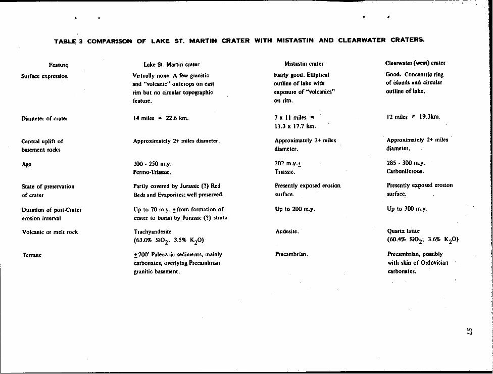
............ ------------------------------------------------------~--------------~----------------------.... ~--~------------~----~--~--------;
TABLE 3 COMPARISON OF LAKE ST. MARTIN CRATER WITH MISTASTIN AND CLEARWATER CRATERS.
Featur~
Surface expression
Diameter of crater
Central uplift of
basement rocks
Age
State of preservation
of crater
Duration of post-Crater
erosion interval
Volcanic or melt rock
Terrane
Lake St. Martin crater
Virtually none. A few granitiC)
and "volcanic" outcrops on east
rim but no circular topographic
feature.
14 miles = 22.6 km.
Approximately 2+ miles diameter.
200 • 250 m.y.
Permo·Triassic.
Partly covered by Jurassic (?) Red
Beds and Evaporites; well preserved.
Up to 10 m.y. ±from formation of crater to burial by Jurassic (?) strata
Trachyandesite
(63.0% Si02; 3.5% K20)
± 700' Paleozoic sediments, mainly
carbonates, overlying Precambrian
granitic basement.
Mistastin crater
Fairly good. Elliptical
outline of lake with
exposur~ of ''volcanics'!
on rim,
1 x II miles ...
11.3 x 11.1 km.
Approximately 2+ miJes
diamet~r.
202 m.y.±.
Triassic.
Presently exposed erosiOn
surface.
Up to 200 m.y.
Andesite.
Precambrian.
Clearwater (west) crater
Good. Concentric ring of islands and circular
outline of lake,
12 miles = 19.3km.
Approximately 2+ miJe!;
diameter.
285 • 300 m.y.
Carboniferous.
Presently exposed erosion
surface:
Up to 300 m.y.
Quartz latite (60.4% Si02; 3.6% K20)
Precambrian, possibly
with skin of Ordovician
carbonates.
Vl ....J
S8
I) Impact' onhe' meteorite through the pre-existing Paleozoic rock cover intn' the Precambrian basement rock.
2) Formation of a crater or ejecta void" during which the meteorite is completely' melted or vaporized, along with the rock in the impact region, with most of the melted rock being ejected. Uplift of the rim rocks. Rocks underlying the crater are strongly shock metamorphosed; the degree of shock metamorphism decreases laterally and with depth, although the variation in grade of metamorphism may be erratic.
3) In large craters, generally those over 8 to 10 miles in diameter" central uplifts are formed due to rebound" possibly by deep sliding along slip surfaces, and accompanied by slumping of sections of the rim into the crater; the central uplifted rocks show strong shock metamorphic effects continuing to a considerable depth, local brecciation and shearing, and are cut by pseudotachylite veinlets.
4) The above events occur within a short time interval; associated with the sliding and central uplift is the fall-back into the crater of highly shocked and melted breccia (suevite) that may form a sheet of melt rock. When solidified" this rock contains abundant fragments or inclusions of shocked and partially remelted or recrystallized country rock.
VOLCANIC HYPOTHESIS
Structures of undoubted volcanic origin most similar to the Lake St. Martin crater structure are the larger collapse calderas or cauldron subsidence structures. However, these differ in their large volume of volcanic products, including ash-flow tuffs, and do not produce the shock metamorphic features or peculiar glassy pseudotachylytes associated with the Lake St. Martin-type struct4res.
A theory has been proposed by Bostock (1969), for the Clearwater Lake crater, that involves the evolution of volatile material from the mantle or above a magma at depth, in a volcanicly inactive zone. Build-up of pressure results in the arching or doming of overlying rocks, followed by rise of the volatiles. As pressure builds up, fracturing in the dome occurs, followed by explosive release of volatiles, of sufficient energy to cause formation of maskelynite. This may be follo~ed by rapid exhalation of volatiles, and by foundering of the uplifted dome along ring faults. Extrusion of lava occurs, and a central plug of basement rock is subsequently uplifted.
Currie (1965) has suggested that the Canadian craters are located on or near an v,is along which major uplift of the Canadian Shield areas occurred (during late Paleozoic time); the craters reo suIt from deep seated gaseous explosive volcanism associated with this major crustal up warping.
COMMENTS ON METEORITE IMPACT HYPOTHESIS
Features of the Lake St. Martin crater explainable by, or compatible with, a meteorite impact origin are:
I) Circularity of the structure - although not definitely confirmed, the known distribution of evaporite and red beds, trachyandesite, fresh granite, uplifted Paleozoic strata, and altered gneiss is best explained by a circular structure 14
miles in diameter.
2) Complex: nature orthe structure indicating an explosive event of catastrophic nature: a) uplift of Precambrian and overlying Paleozoic rock by several hundred feet in an area' surrounding
the crater. b) presence within the crater of several hundred feet of rock showing an extreme degree of breccia
tion.
c) slumping of large blocks of carbonate rock into the crater. d) uplift and shock metamorphism of a block, or area of Precambrian gneiss in the ~'of the
crater structure. 3) The peculiar petrographic features of the trachyandesite - the abundant inclusions of shock met
amorphosed mineral grains and fragnlents and the lack of phenocrysts and flow structures indicate this rock is not a "typical" extrusive rock.
4) The presence of shock metamorphic features is indicative of extremely high pressures, and associ· ated high temperatures.
S) The high degree of shock metamorphism in the central altered gneiss, and the decrease of the intensity of shock with depth.
6) Location of the structure within a stable cratonic area far removed from any features of igneous or tectonic origin. The age of the feature (permian-Triassic) is also unusual in that no events of a' volcanic nature of this age are known (except for the possible craters 1) within several hundred miles of the Lake St. Martin area.
Some of the features of the Lake St. Martin crater that are difficult to explain by the pure meteorite impact theory are: I) A meteorite impact origin implies essentiaUy a single short·lived event. The presence orwhat
appear to be a number of different and discrete breccia and trachyandesite beds seems more compatible with a series of pyroclastic and lava eruptions and/or emission from several different vents. Trachyandesites overlie granitic breccia in LSM·I, and underlie polymict breccia in LSM·3. The thick "granitic breccia" section in the Bralorne well may represent a still lower breccia interval, and the andesitic rock at the bottom of the Bralome core could poSSIbly represent still another trachyandesite layer. According to the meteorite impact theory, the melt rock should form the uppermost layer of the crater infUl, and occur also as a thin skin over the brecciated and shocked b3SCment rocks.
2) The origin of the aphanitic igneous fragments in the LSM-3 breccia beds is problematical. If the fragments are pieces of an original trachyandesite body, then a sequence of intrusion, at least partial solidification, and subsequent fragmentation is suggested. However, the fragments have a predominantly glassy texture as contrasted with the flIlely crystalline texture of the trachyandesite, and the inclusions within the fragments (partly shocked) do not have the reaction rims typical of the trachyandesite. For the aphanitic igneous fragments to have been formed by melting due to meteorite impact, to have picked up shocked and unshocked inclusions, and then been incorporated into a fall-back breccia above the trachyandesite involves a complex sequence of events -not impossible to postulate, but difficult to visualize. The gradual increase in abundance of carbonate fragments in the upper part of the breccia adds a further complication.
Objectively it is difficult to explain the origin of the breccia section in LSM-3 by either the volcanic or meteorite impact theory. on present evidence. More detailed study of this section could conceivably provide evidence that would lead to the solution of the problem of origin.
59
60
3) The frachyandesit'e is' somewhat dIfficult to reconcile as a melt rock. formed by meteorite impact' although some of the lithologic characteristics seem contradictory. Despite the abundance of granitic rock fragments occurring as inclusions in the trachyandesite, most of the fragments show little evidence of resorption into the matrix, as might be expected if the trachyandesite was formed from melted fall-back breccia. On the other hand the patchy variations in mineral distribution and crystal grain size suggest possible complete melting and recrystallization of some inclusions_ Also, the trachyandesite appears to be megascopically homogeneous in composition, both vertically and areaJIy. A greater degree of lithologic variation, might be expected in a meteoritic melt rock, especially in view of the thick layer of carbonate rocks present at the time of impact, and the predominantly granitic composition of the basement rocks comprising the crater rim.
It must nevertheless be pointed out that,. on the limited data available for the Bralorne hole, the 870 feet of "granitic" breccia appears to be quite Uniform, and the chemical analyses of the fine microbreccia portion of these breccias, which may well represent an "average" basement rock,. closely resemble the analysis of the trachyandesites. Homogenization during brecciation to give a rock of trachyandesitic composition is thus possible. On the other hand, the polymict breccias of LSM-3, with their high content of carbonate fragments, differ markedly from the Bralorne breccia and trachyandesite.
The chemical composition of the shocked gneissic core is also not greatly different from that of the trachyandesite although chemical data are not sufficient to permit any type of statistical comparison of the various rock types.
In general, the composition of the trachyandesite is roughly compatible with the composition of at least some of the basement rocks and breccias, and consequently derivation of the trachyandeiste from the basement rocks by explosive impact and melting due to meteorite impact cannot be ruled out.
4) The apparent concentration oftrachyandesite near the crater rim and sparsity near the center appears more compatible with Currie's concept of a ring dyke type of extrusive.
5) The presence of the uplifted plug of Precambrian basement rocks in the center of the crater is also somewhat difficult to account for by the volcanic hypothesis.
COMMENTS ON VOLCANIC HYPOTHESIS
The principal bone of contention with the volcanic hypothesis. for the Lake St. Martin crater as well as the other craters, is the problem of the origin of the shock metamorphic features. In brief. proponents of the volcanic theory contend that the shock pressures required to form shock metamorphic features such as planar features in quartz and feldspar. and development of maskelynite. can occur during rather special high temperature explosive volcanic eruptions.
The proponents of a meteoritic origin for this and other craters would contend that the pressures required to form these shock metamorphic features are so high - in the order of at least several hundred kilobars - that they are beyond the crustal strength of the earth and consequently could not have been generated by any type of volcanic activity. They cite as supporting evidence shock metamorphic effects formed by known meteorite impacts and by atomic explosions.
The problem as' to the origin of the shock metamorphic features is beyond the scope of this discussion, but if shock metamorphic features can be formed by volcanic eruption, the volcanic theory of origin for the Lake St. Martin crater would seem to be most plausible, although a possible meteoritic origin stiU could not be ruled out.
Some of the lithologic peculiarities onhe trachyandesites,. which pose a problem to the origin by meteorite impact, also are not easily explained by the volcanic hypothesis - e.g. the microscopic inhomogeneity, the abundance of inclusions (in part shock metamorphosed), the lack of flow structures, and the lack of phenocrysts.
METEORITIC-VOLCANIC COMPOSITE HYPOTHESrS
The composite theory of meteorite impact triggering volcanic eruption would appear to avoid many of the arguments against the separate hypotheses. Currie (1968) has questioned the composite theory of origin on the basis that, for most Canadian craters, there is a similarity between the "volcanic" or melt rock and the basement rock, and he argues that this would not be expected for a volcanic extrusive triggered by meteorite impact. He proposes melting of near surface rocks by solutions derived from alkaline ultra basic intrusives. and. as noted previously. suggests that the location of the crater is controlled by a major tectonic feature involving uplift of the Precambrian Shield. Geochemical data are not suffiCient to determine if Currie's objection to the composite theory of origin can be applied ill the case of the Lake St. Martin crater.
SUMMARY
Solution of the problem as to the origin of the Lake st. Martin crater will require additional driUing data to supplement the sparse outcrop and well control data presently aVailable. Deepening of the Bralorne and LSM·l, 3, and 4 holes would give a good cross-section of the crater lithology and structure. Detailed magnetic, gravity and possibly seismic profiles would also provide valuable ad· ditional data. Also, much detailed petrographic and mineralogic work remains to be done on the tra· chyandesites. breccias, and shock metamorphosed gneiss.
The foUowing is a summary of the known structural and lithologic features of the St. Martin crater that will have to be fitted in to any theory of origin. It should also be stressed that only a very
-limited amount of data are presently available to "define" these features.
1) A crater with approximately circular configuration, 14 miles in diameter, and a minimum present depth of 1050 feet (original minimum depth of 2000 feet).
2) A structurally uplifted rim around the crater with uplift of Precambrian basement rocks and lower Paleozoic strata of at least 700 feet. The amount of structural uplift decreases rapidly away from the rim and is negligible at a distance of 6 to 7 miles from the rim. The total diameter of the structurally disturbed area is 26 to 28 miles.
3) A ring of downfaultcd and brecciated limestone beds of probable Devonian age immediately within the crater rim; the amount of structural down faulting is at least 300 feet.
61
62
4) A central. sharply uplifted core~ 2 to 1 miles' in diameter,. consisting ofhighly shocked and altered basement gneiss; relief of this uplift is a minimum of 1050 feet above the crater floor. Shock metamorphic features are present to a depth of at least 400 feet in the core. and there is some evidence for a decrease in grade of shock metamorphism with depth.
S) Between the central core and the peripheral carbonate breccias is a thick sequence (>870 feet) of granite and polymict (suevitic) breccias; several different types of breccia are present. and tra'chyandesite fragments occur in the breccias. Vertical gradations in breccia composition (e.g. carbonate fragments) are also evident.
6) Aphanitic igneous rocks of trachyandesite compositIon occur both above and below suevitic breccias. Trachyandesite appears to be most common near the crater rim. and is quite uniform in overall composition. but quite variable on a microscopic scale.
7) The age of the crater is late Premian to possibly early Triassic (200-250 m.y.).
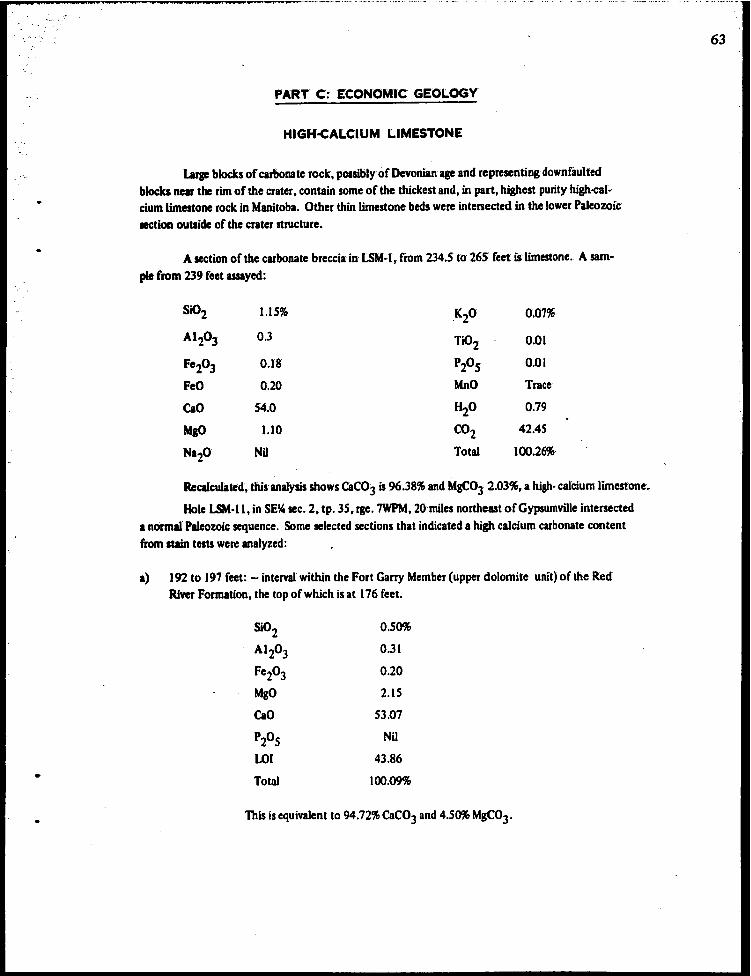
•
PART C: ECONOMIC GEOLOGY
HIGH~ALCIUM LIMESTONE
Larp blocks of carbonate rock, possibly of Devonian age and representing downfaulted blocks near the rim of the crater, contain some of the thickest and, in part, highest purity high-caldum limestone rock in Manitoba. Other thin limestone beds were intersected in the lower Paleozoic section outside of the crater structure.
A section of the carbonate breccia in LSM-r, from 234.5 to 265 feet is' limestone. A sam ..
ple from 239 feet assayed:
Si02 1.15% KO . 2 0:07%
AI2O) 0.3 Ti02 am Fe203 0.18 P20 5 0.01
FeO 0.20 MnO Trace
CaO 54.0 H2O 0.79
MaO 1.10 CO2 42.45
Na20 Nil Total 100.26%
Recalculated',. this analysis shows CaCO) is 96.38% and MgC03 2.03%. a high· calcium limestone~,
Hole LSM-ll,.in SE~ sec. 2, tp. 35, rge. 7WPM, 20 miles northeast ofGypsurnville intersected a normal Paleozoic sequence. Some selected sections that indicated a high calcium carbonate content from stain tests we", analyzed:
a) 192 to 197 feet: - interval within the Fort Garry Member (upper dolomite unit) of the Red River Formation, the top of which is at 176 feet.
SiO 2 0.50%
AI 203 0.31
Fe203 0.20
MgO 2.l5
Cao 53.07
P20 5 Nil
LOI 43.86
Total 100.09%
This is equivalent to 94.72% CaC03 and 4.50% MgC03'
63
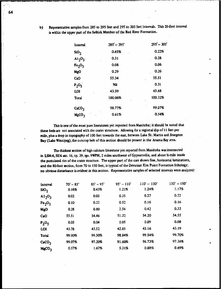
64
b) Representative samples from 285 to 29S feet and 295 to 305 feet'int'ervalS., This 2~foot interval is wiL'lin the upper part of the Selkirk Member ofthe Red River Formation.
Interval 28S'- 295' 29S' -305'
Si02 0.45% 0.22%
Al 20)' 0.31 0.28
Fe203 0.08 0.06
MgO 0.29 0.26
CaO SS.34 5S.51
P205 Nil 0.31
LOI 43.59 43.68
Total 100.06% 100.32%
CaCO] 98.77% 99.07%
MgCO] 0.61% 0.54%
This'is one of the most pure limestones yet reported from Manitoba;. it should be notl:({ that these beds are not associated with the crater structure. Allowing for a regional dip of II feet per mile, plus a drop in topography of 100 feet towards the east, between Lake St. Martin and Sturgeon Bay (Lake Winnipeg), the outcrop belt of this section should be present in the Anama Bay area.
The thickest section of high· calcium limestone yet reported from Manitoba was intersected in LSM-6, SE~ sec. 16, tp. 39, rg\:. 9WPM, 2 miles southwest of Gypsumville, and about ~·mile inside the postulated rim of the crater structure. The upper part of the core shows fine, horizontal laminations,. and the SO-foot section, from 70 to ISO feet, is typical of the Devonian Elm Point Formation lithology; no obvious disturbance is evident in this section. Representative samples of selected intervals were analyzed:
Interval 70'- SS' SS' - 95' 95' - 110' 110' - DO' 130' - [SO'
Si02 0.16% 0.43% 1.21% 1.24% 1.17%
A1 20 3 0.02 0.03 0.35 0.27 0.22
FC203 0.10 0.22 0.52 0.16 0.16
MgO 0.28 O.SO 2.54 0.42 0.33
CaO S5.51 54.46 51.32 54.20 54.55
P205 0.05 0.04 0.05 0.09 0.08
LOI 43.78 43.52 42.S5 43.16 43.19
Total 99.90% 99.50% 9S.84% 99.S4% 99.70%
CaC03 99.07% 97.20% 91.60% 96.73% 97.36%
MgC°3 0.57% 1.67% 5.31% 0.88% 0.69%
A weighted average for the 80·foot interval shows 96.24% CaCO] and 1.70% MgC03, the thickest section of high-calcium limestone in Manitoba. Whether or not the deposit is economic will depend upon its purity, its extent, its distribution (which may be erratic), and its relation to
market areas with respect to other deposits in the Lily Bay.steep Rock area.
SILICA SAND
Drill hole LSM·2, drilled ~·mile south of The Narrows of Lake St. Martin,.at a bearing of 3300 and a dip of 450 , intersected the Winnipeg Formation from 53 to 95 feet. Between 53 feet and 69 feet, the formation consists of:
53·54 feet: shale,. mainly reddish brown. thin sand interbeds-54-64 feet: (6 ft. recovered); sand, in part consolidated; red shale interbeds 64-65 feet: sand, consolidated 65·69 feet: shale, purplish red, bedded
No core was recovered between 69 and 95 feet; the driller reported the interval to be sand;. by analogy with other occurrences of sand within the Winnipeg Formation, it seems- probable that the material will be silica sand of high purity. Unless faulting has removed the sand. it should be present at a shallow depth in the area to the north of drill hole LSM·2.
AGGREGATE MATERIALS
A glacial beach ridge is present in the south part of tp. 35, rge. 7WPM, and is the source of lOcal aggregate; it is unusual in being composed predominantly of well rounded pebbles and cobbles· of
carbonate rock.
Other gravel pits are present in sec. 31, tp. 32, rge. 7WPM, and in the NW~ sec. 27, tp. 32,
rge.8WPM.
Granite Hill could be the source of crushed stone for aggregate, bu t this locally prominent topographic feature could be the focal point for a recreational area, as it provides a scenic promontory rising 7S feet above the flat plains bordering Lake St. Martin and Dauphin River; other granite is present in sec. 31, tp. 33, rge. 7WPM, if aggregate material is required.
GYPSUM
Gypsum deposits have been mined in the Gypsumville area continuously since 1900. and de· posits are of suificient size for many years of continued production.
BASE METALS
The reported presence of native copper in the Lake St. Martin area has long been of interest, and in part gave rise to the present study. Although no in situ occurrences of native copper or any other base metal mineralization have been encountered in the present core hole study, or in the pre·
6S
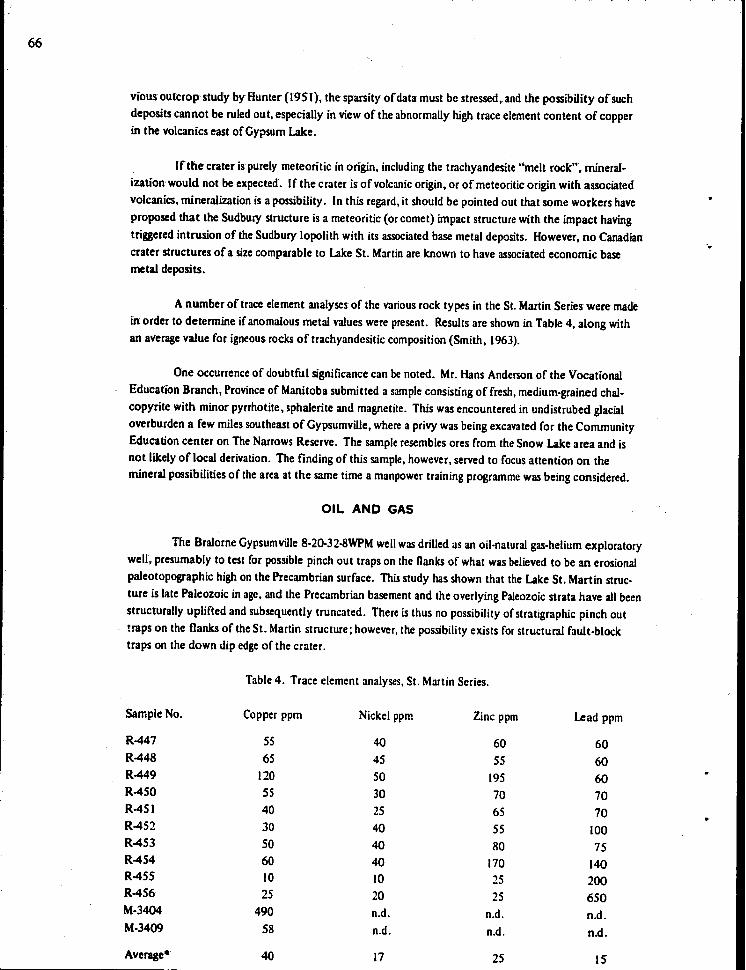
66
vious outcrop study by HUnter' (1951), the sparsity of data must be stressed" and the possibility of such deposits cannot be ruled out, especially in view of the abnormally high trace element content of copper in the volcanics east of Gypsum Lake.
[f the crater is purely meteoritic in origin, including the trachyandesite "melt rock", mineraI~ ization would not be expected. If the crater is of volcanic origin, or of meteoritic origin with associated volcanics, mineralization is a possibility. In this regard, it should be pointed out that some workers have proposed that the Sudbury structure is a meteoritic (or comet) impact structure with the impact having triggered intrusion of the Sudbury lopolith with its associated base metal deposits. However, no Canadian crater structures of a size comparable to Lake St. Martin are known to have associated economic base metal deposits.
A number of trace element analyses of the various rock types in the St. Martin Series were made in order to determine if anomalous metal values were present. Results are shown in Table 4, along with an average value for igneous rocks of trachyandesitic composition (Smith, 1963).
One occurrence of doubtful significance can be noted. Mr. Hans Anderson of the Vocational Education Branch, Province of Manitoba submitted a sample consisting of fresh, medium-grained chalcopyrite with minor pyrrhotite, sphalerite and magnetite. This was encountered in undistrubed glacial overburden a few miles southeast of Gypsumville, where a privy was being excavated for the Community Education center on The Narrows Reserve. The sample resembles ores from the Snow Lake area and is not likely of local derivation. The finding of this sample, however, served to focus attention on the mineral possibilities of the area at the same time a manpower training programme was being considered.
OIL AND GAS
The Bralorne Gypsumville 8-20-32-8WPM well was drilled as an oil·natural gas-helium exploratory well, presumably to test for possible pinch out traps on the flanks of what was believed to be an erosional paleotopographic high on the Precambrian surface. This study has shown that the lake St. Martin structure is late Paleozoic in age, and the Precambrian basement and the overlying Paleozoic strata have all been structurally uplifted and subsequently truncated. There is thus no possibility of stratigraphic pinch out
- traps on the flanks of the St. Martin structure; however, the possibility exists for structural fault-block traps on the down dip edge of the crater.
Table 4. Trace element analyses, St. Martin Series.
Sample No. Copper ppm Nickel ppm Zinc ppm Lead ppm
R447 5S 40 60 60 R448 6S 45 55 60 R449 120 50 195 60 R450 55 30 70 70 R451 40 25 65 70 R452 30 40 55 100 R453 50 40 80 75 R454 60 40 170 140 R455 10 10 25 200 R456 25 20 25 650 M-3404 490 n.d. n.d. n.d. M-3409 58 n.d. n.d. n.d.
Average- 40 17 25 15
'.
•
• Avenge trace element content from igneous rocks with 63% Si02 (equivalent to trachyandesfte) after
Smith (1963).
R447: R448: R449: R450: R451: R452: R453: R454: R455: R456: M·3404: M·3409:
Andrichuk', 10M. 1959
Baillie, A.D~ 1951
Biillie,A.D. 19S2
Bannatyne, B.B. 19S9
&en,R.A. 1904
Currie, K. L. 1965
Curric,K.L 1968
Currie, K. L. 1968a
CUrrie, K. L. 1970
Dawson,.S.r. 18S9
trachyandesite" LSM~l: 22 feet and 135 feet. trachyandesite, LSM·3:274 feet and 276 feet. trachyandesite,Bralorne 8·20-32·8Wat IOS5 feet. pseudotachylyte, LSM4: 15 feet. granitic breccia, LSM·I: 219 feet polymict breccia, LSM·3; 219 feet and 222 feet. granitic breccia matrix, BraJorne 8·20-32·8W: at 430' ·440 feet. altered gneiss, LSM-4: 388 feet. carbonate breccia, LSM·I: 239 feet. carbonate breccia, LSM·6; i 94 • 200 feet (contains pyrite)~ trachyandesite, Sugar Island outcrop. trachyandesite, east of Gypsum Lake, vesicular rock.
SELECTED REFERENCES
Ordovician and Silurian stratigraphy and sedimentation in southern M'anitoba, Canada; Bun. Am. Assoc. Petrol. Geol., vol. 43, No. 10, pp. 2333·2398.
Silurian geology ofthe Interlake area,. Manitoba; Manitoba Mines Branch, Publ. SO-I.
Ordovician geology of the Lake Winnipeg and adjacent areas, Manitoba; Man·, itoba Mines Branch, Publ. S 1·6. 64 p.
Gypsum - anhydrite deposits of Manitoba; Manitoba Mines Branch,Publ. S8·2 ..
Amygdaloid in Manitoba; Geo!. Surv. Can., Summ. Rept. 1903, p. 9A.
Analogues of lunar craters on the Canadian Shield; Ann. N.Y. Acad. Sci., vol. 123, Art. 2, pp.9IS·940.
Geochemistry of some large Canadian craters; Nature, vol. 218 pp. 4S7-459.
Mistastin Lake, Labrador: A new Canadian crater; Nature, vol. 220, pp. 776-777.
Lake St. Martin structure, Manitoba; Report of Activities, Part A: April to October, 1969; Geol. Surv. Can., Paper 70-1, Part At p. Ill.
Report on the exploration of the country between Lake Superior and the Red River settlement and between the latter place and the Assiniboine and Saskatchewan; Canada, Legislative Assembly r., vol. 19, Appendix 36.
67
68
Deer, W. A., Howie, R. A.,. Zussman,.J. 1963 Rock forming minerals; Longmans, London.
Dence,M.R. 1964
Dence,M. R. 1968
A comparative structural and petrographic study of probable Canadian· meteorite
craters; Meteorites, vol. 2, pp. 249-270.
Shock zoning at Canadian craters~ petrography and structural frnplications. In~
Shock metamorphism of natural materials, B. M. FrenCh and N. M. Short, (eds.);. Baltimore, pp. 169-184.
Denee,. M. R. (in preparation) 1970 Shock metamorphism at the Lake St. Martin, Manitoba, structure; Abstract,
Annual Meeting, Geological Association of Canada.
Dominion Obsemtories Branch (in report by R. J. Buck) 1965 Winnipeg-Gypsumville, Manitoba; Gravity Map Series No. 49.
FrenCh, B. M., and Short, N. M., (cds.) 1968 Shock metamorphism of natural materials; Mono Book Corp., Balfimore,.644 p~
Hoque,M. 1967
Hunter, H. E. 1951
Structure and petrology of the Gypsumville gypsum deposit; M.Sc. thesis, University of Saskatchewan.
Igneous rocks in the Lake St. Martin area, Manitoba; Manitoba Mines Branch,. Publ. 50-10.
Lockwood Survey Corporation Ltd. 1967 Reconnaissance photo-interpretation of the Interlake region - Manitoba. Open
me report, Manitoba Mines Branch.
McCabe, H. R. 1966
McCabe, H. R. 1967
Morgan,.J. H.
Revised stratigraphic map series; Manitoba Mines Branch.
Tectonic framework of Paleozoic formations in Manitoba; C.1. M. M. Bull., vol. 54, No. 663, pp. 765·774.
1940 Pre-Paleozoic inliers in the vicinity of Gypsumville, Manitoba; unpublished report, Manitoba Mines Branch.
saskatchewan Geological Society 1958 Report of the lower Paleozoic names and correlation committee.
Sinclair, G. W. 1959
Smith,F.G. 1963
Succession of Ordovician rocks in southern Manitoba; Geol. Surv. Can., Paper 59-5, 9 p.
Physical geochemistry; Addison-Wesley, Reading, p. 410.
..
..
•
•
Stearn,C. W. 19S6 Stratigraphy and paleontology of the' Interfake Group and Stonewall Formation
of Southern Manitoba; Geol. Surv. Can., Memoir 281.
Taylor, F. C. and Dence, M. R. 1969 A probable meteorite origin for Mistastin Lake, Labrador,.Can .. I. Earth Sci., voL
TyrreU, I. B. 1889
Tyrrell, I. B. 1893
Wallace, R. C. 1925
3,pp.394S.
Gypsum deposits in northern Manitoba; Can. Rec. Sci., vol. 3, No., 6, pp. J53~360.
Report on northwestern Manitoba with portions of the adjacent dIstricts of Assiniboia and Saskatchewan; Geol. Surv. Can., Ann. Rept. I 89()'9I, pt. E.
The geological formationS' of Manitoba; The Natural History Society of Manitoba.
Wardlaw, N. C.,.Stauffer,.M. R.,and Hoque, M. 1969 Striations, giant grooves, and superposed drag foldS, Intedake area, Manitoba: Can.
I. Earth Sci., vol. 6, No.4, (pt. I). pp. S77·S93 •
69
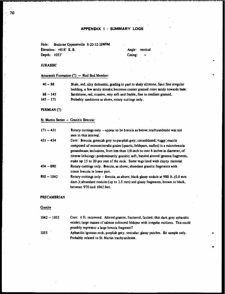
70
APPENDIX 1 • SUMMARY LOGS
Hole: Bralorne Gypsumville 8·20"32~28WPM Elevation: +818' K. B. Angle: vertical
Casing; Depth: 1055'
JURASSIC
Amaranth Formation (:) - Red Bed Member:
40-88
88 -145 145 - 171
PERMIAN(?)
Shale, red, silty dolomitic,. grading in part to shaly siltstone~. faillt fUle irregular bedding, a few sandy streaks; becomes coarser grained more sandy towards base~ Sandstone, red, massive, very soft and friable, fine to medium grained. Probably sandstone as above, rotary cuttings only.
St. Martin Series - Granitic Breccia:
171 - 431
431 -454
454 -890
890-1042
PRECAMBRIAN
Granite
1042-- lOS5
lOSS
Rotary cuttings only - appear to be breccia as below;. trachyandesite was not seen in this interval. Core: Breccia, greenish grey to purplish grey; consolidated; vuggy; matrix composed of monomineralic grains (quartz, feldspars, mafics) in a microbreccia groundmass; inclusions, from less than 118·inch to over 8 inches in diameter, of diverse lithology; predominantly granitic; soft, banded altered igneous fragments, make up IS to 20 per cent of the rock. Some vugs lined with clayey material. Rotary cuttings only. Breccia. as above; abundant granitic fragments with minor breccia in lower part. Rotary cuttings only - Breccia, as above; black glassy nodule at 900 ft. (0~8 mm diam.);abundant nodules (up to 2.5 mm) and glassy fragments, brown to black, between 970 and 1042 feet.
Core: 6 ft. recovered. Altered granite, fractured. faulted; thin dark grey aphanitic veinlet; large masses of salmon coloured feldspar with irregular outlinc:s. This could possibly represent a large breccia fragment? Aphanitic igneous rock, purplish grey, vesicular; glassy patches. Bit sample only. Probably related to St. Martin trachyandesite.
..
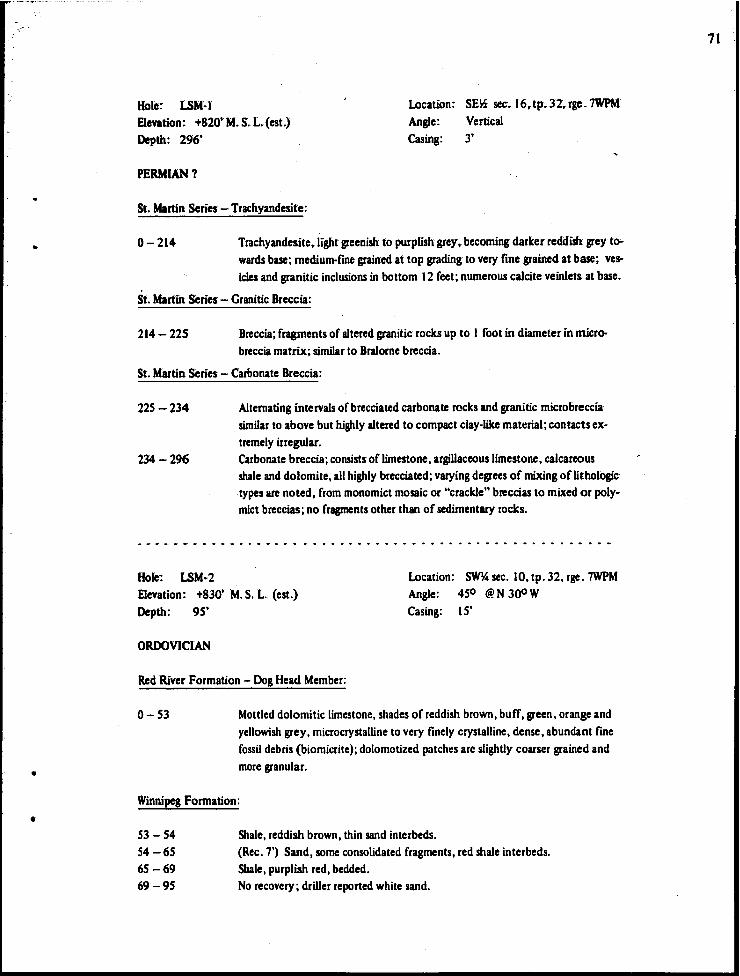
-" .. -'
•
•
•
Hole: LSM~ r location: SE~ sec.16,.tp~J2~.rge. 7WPM
Elevation: +820'M.S.L.(est.) Depth: 296'
Angle: Vertical Casing: 3'
PERMIAN?
St. Martin Series - Trachyandesite:
0-214 Trachyandesite, light greenish to purplish grey, becoming darker reddish grey tawards base; medium-fme grained at top grading to very fine grained at base; vesIcles and granitic inclusions in bottom 12 feet; numerous calcite veinlets at base.
St. Martin Series - Granitic Breccia:
214- 225 Breccia; fragments of altered granitic rocks up to I foot in diameter in microbreccia matrix; similar to Bralorne breccia.
St. Martin Series - Carbonate Breccia:
225 -234
234-296
Hole: LSM-2
Alternating intervals of brecciated carbonate rocks and granitic microbreccia similar to above but highly altered to compact c1ay"like material; contacts extremely irregular. Carbonate breccia; consists of limestone, argillaceous limestone, calcareous shale and dolomite, all highly brecciated; varying degrees of mixing of lithologic types are noted, from monomict mosaic or "crackle" breccias to mixed or polymict breccias; no fragments other than of sedimentary rocks.
Elevation: +830' M.S. L. (est.) location: SW~ sec. 10, tp. 32, rge. 7WPM Angle: 450 @ N 300 W
Depth: 95' Casing: IS'
ORDOVICIAN
Red River Formation - Dog Head Member:
0-53 Mottled dolomitic limestone, shades of reddish brown, buff, green, orange and yellowish grey, microcrystalline to very finely crystalline, dense, abundant fme fossil debris (biomicrite); dolomotized patches are slightly coarser grained and more granular.
Winnipeg Formation:
53-54 54-65 65 -69 69-95
Shale, reddish brown, thin sand interbeds. (Rec. 7') Sand, some consolidated fragments, red shale interbeds. Shale, purplish red, bedded. No recovery; driller reported white sand.
71
72
Hole: LSM-3 Location: NE~ sec. 26,. tp. 32~ rge. 9WPM Elevation: +840' M~ S. L (est.) Depth: 300'
Angle: Vertical Casing:
JURASSIC (1)
Amaranth Formation (1) - Evaporite Member:
0- 34 34 -124
124 - 138
Gypsum, thin bedded,clay seams Anhydrite, minor clay and gypsum with gJauberite 109 to 124. Anhydrite, interbedded red dolomitic shale.
Amaranth Formation (1) - Red Bed Member:
138 -160
160-183
183 -189
PERMIAN (1)
Red shale, silty, dolomitic; abundant satin spar stringers parallel to bedding; becoming sandy in bottom 2 feet. Breccia; sparse to abundant angular to sub rounded fragments of dolOmite,. "granite" , and greenish rock closely resembling the St. Martin trachyandesite; matrix is a medium - to coarse-grained dolomitic sandstone; a few thin satin spar stringers are present. Dolomite, silty, argillaceous; several inclusions of underlying polymict microbreccia near base; sharp horizontal contact with:
St. Martin Series - Polymict Breccia:
189 -225
225 - 265
Polymict breccia; highly altered friable appearance; color is vaguely mottled shades of reddish to greenish grey; fragments in upper part are predominantly angular carbonate with pronounced alteration rims; soft reddish to greenish laminated fragments, possibly h.ighly altered "trachyandesite" fragments are common and show vague outlines, merging into matrix; granite fragments common and range from fresh-appearing to h.ighly altered; trace sandstone fragments and rounded frosted quartz grains; matrix is flOe quartz-feldspar microbreccia with clay-like groundmass. Polymict breccia as above but carbonate fragments rare or absent; red altered aphanitic igneous fragments predominant and oflarger size and partly vesicular; granitic fragments to 4" common; matrix becomes a minor constituent.
St. Martin Series - Trachyandesite:
265 - 300 Trachyandesite, medium purplish grey, very line grained, massive, abundant fine quartz and feldspar inclusions; granitic fragments to 4" common, in part vesiculated; a few vesicles and greenish to reddish banded amygdale-like inclusion!; several porous, vuggy altered zones.
•

.. , .... ,.'-"..'- '.'
..
•
•
Hole: LSM4 Elevation: +840' Depth: 396'
PRECAMBRIAN
Location; NW~ sec. 27, (p. 32, rge. 8WPM Angle: Vertical Casing: IS feet
Shock-metamorphosed gneiss:'
IS - 17 17 - 180
180 - 297
297 - 396
Pseudotachylyte'" brownish abundant inclusions. Gneiss, medium to coarse grained; exhibits weak.to fairly intense defonnation features (fracturing, folding and breCCiation); cut by veinlets of pegmatite and pseudotachylyte. Upper part has much of the quartzofeldspathic material altered to chalky white to opalescent appearance, and mafies almost completely altered to iron oxide. Pegmatite veins are present at 63 to 67 feet and 104 to 106 feet. Gnews, as above; mafies less altered, biotite and hornblende present; lower degree of distortion. Pegmatite veins occur at 235 to 237 feet, 275 to 277 feet, 289 to 291 feet"and 293 to 297 feet. Gneiss, hornblende-biotite, fractured, only minor pegmatite and pseudotachy:.. lyte; good gneissic appearance in places •
.. ' ................................................................ _-- ............... ..
Hole: LSM-S Location: S~ sec. 28, (p. 32, rge. 8WPM Elevation: +820' M. S. L. (est.) Depth: 104'
Angle: Vertical Casing: 104'
0-104 Overburden; clay till with scattered boulders; no bedrock.
...................................................................... -
Hole: LSM~6
Elevation: +810' M.5.L. (est.) Depth: 231'
Location: SE~ sec. 16, tp. 32. rge. 9WPM
Angle: Vertical Casing: 42 feet
PERMIAN?
St. Martin series - Carbonate Breccia:
42 - 70
70 -153
IS3 - 157
IS7 - 232
Umestone, dolomitic limestone, and dolomite, interbedded. fine horizontal laminations. Umestone. mottled pale yellowish to brownish buff. massive; high calcium limestone identical in appearance to Devonian Elm Point Formation. Interbedded dolomite and limestone. fractured with vuggy solution cavities near base. Recovered only 8 feet broken core. mixed limestone, dolomite and red calcareous shale.
73
74
Hole: LSM~7 Location: NW~ sec. 5,. tp. 32, rge.9WPM
ElevaHon: +815' M.S.L.(est.} Depth: 183'
Angle: Vertical Casing: 29 feet.
ORDOVICIAN
Stony Mountain Formation - Gunton Member:
26 - 102 Dolomite, pale yeUowish buff~ faint!y mottled,. microcrystalline.
Stony Mountain Formation - Gunn Member (Stony Mountain Shale):
102 - 149 Argillaceous dolomite, mottled shades of medium to light greenish grey;. mottling has characteristic tubular or vermiform appearance.
Red River Formation - Fort Garry Member:
149 - 180
Hole: LSM~
Dolomite, pale yellowish to greyish buff, microcrystalline, dense to moderat'ely granular, trace white chert.
Location: SE~ sec. 25, tp. 32, rge. 8WPM Elevation: +830' M. S. L. (est.)
Depth: 107' Angle: Vertical Casing: 107 feet.
0-107 Overburden; clay till with scattered boulders, no bedrock.
Hole: LSM~9 Location: NW~ sec. 22, tp. 32, rge. 7WPM Elevation: +805' M. S. L. (est.) Depth: 110'
Angle: Vertical Casing: 110 feet
0-110 Overburden; clay till with scattered boulders, no bedrock.
Hole: LSMrlO Location: SE~ sec. 12, tp. 34, rge. 7WPM Elevation: +805' M. S. L. (est.) Depth: 180'
Angle: Vertical Casing: 83 feet
ORDOVICIAN
Stony Mountain Formation - Gunn Member:
86 -95 Dolomite, light grey buff, faintly speckled banded and mottled, microcrystalline, slightly granular, abundant fine fossil fragments.
Red River Formation - Fort Garry Member:
95 - 180 Dolomite, mostly microcrystalline dense to sUblithographic, color varies from pale yellowish brown to medium grey and purplish grey, in part shows prominent mottling, minor fme horizontal lamination; thin carbonate breccia at liD probably intraformational.
..
•
•
•
•
Hole: ISM·I1 Location: SE~ sec. 2, tp~ J5, rge. 7WPM
Elevation: +795' M. S. L. (est.)
Depfh: 50S'
Angle: Vertical Casing: 21 feet
ORDOVICIAN
Stonewall Formation'(?):
21- 46 Dolomitt, pale grey to yellowish buff,. in part faintly mottled, microcrystaIline~. dense to slightly granular, some coarse VUgs)' porosity near base; at 36', a I·fool interval with bands and patches of grey argillaceous dolomite.
Stony Mountain Formation - Gunt!>n Member;
46- 49 49 -122
Dolomite, sHty and slightly argillaceous, medium light bluiSh grey, banded. Dolomite, pale yellowish buff, massive, microcrystalline, dense to slightly granular; becoming denser and showing faint to prominent streaking and mottling
in bottom 11 feet.
Stony Mountain Formation - Gunn Member(Stony Mountain Shale):
122 -176 Dolomite,. slightly to moderately argillaceous, mottled and streaked shades of medium to light grey and purplish grey, mottling shows characteristic ver·
miform pattern, sparsely fossiliferous.
Red RiverFormation - Fort Garry Member:
176 -189
189 -205
205 -272
Dolomite, pale yellowish buff with grey argillaceous streaking, microcrystalline.
chert nodules to 4 inches~ Interbedded limestone, dolomite, and breccia; limestone mostly brownish buff fmely crystalline subsaccharoidal, some fine argillaceous partings; dolomite buff to grey, partly laminated; breccia beds of angular limestone and dolomite in cal· careous shale matrix (intraformational breccia).
Dolomite, variable,light grey to yellowish buff, some purplish grey mottling, microcrystalline, sublithographic, some argillaceous bands.
Red River Formation - Selkirk Member:
272 - 283.5
283.5 -307
Dolomite, in part calcareous, becoming more calcareous towards base, microcry· stalline, faintly mottled and streaked grey to buff. Umestone, pale grey to greenish grey. microcrystalline dense at top grading downward to coarse crinoidal biosparite (a high calcium limestone) .
7S
76
307 - 330 Limestone~ dolomitic, dolomite' diSseminated in calcareous matrix"microcry' stalline to very fmely crystalline, moderately granular, irregular streaking and mottling (but not similar to Tyndall Stone); chert nodules to 6" common towards base; increasingly dolomitic towards base:
Red River Formation - Cat Head Member:
330-398 Calcareous dolomite, light grey buff" faintly streaked and mottled" microcrystalline granular; good fine intergranular porosity; white chert nodules to 2 inches common.
Red River Formation - Dog Head Member:
398 -493 Dolomitic limestone, mottled shades of pale grey to brownish buff; darker' patches highly dolomitized, microcrystalline to very fmely crystalline,. dense, tight, fine fossil debris (biomicrite); becoming reddish towards base.
Winnipeg Formation:
493 -50S Shale and sandy shale, mottled shades of purpliSh red and green.
• e ••• - ••.• ' ......... .,_ ...................... _". e' .............................. _ ••••
Hole: LSM·l2 Elevation: +805' M.S. L.(est.} Depth: 70'
0-70 Overburden, no bedrock
Location: SW~ sec. 4, tp. 32. rge. 8WPM' Angle: Vertical Casing: 70 feet
.. ..' .. .. e' ... ' _ e" ." .. .. .. "" .. .. .. .. .. .. .. .. .. .. .. .. .. .. ... .. ... .. ... .. .. ... .. ... ... .. .. ... ... .. .. ... .. .. .. ... e' ...
Hole: LSM~11 Location: NE~ sec. 24. tp. 30. rge.IOWPM Elevation: +820' M. S .. L (est.) Depth: 236'
Angle: Vertical Casing: 7 feet
SILURIAN
Interlake Group:
7 - 236' Dolomite, fairly uniform, light buff to greyish white. microcrystalline dense to subliiliographic, some coarser grained intervals, several thin shaly beds.
•
-". .... . ~ .. '
•
•
•
Hole: LSM·14
Elevation: +820' M. S. L. (est) Depth: 199'
PERMIAN (1)
St. Martin Series - Carbonate Breccia:
Location: SW% sec .. 4, tp~. 33, rge; 9WPM Angle: Vertical Casing: 28 feet
28 -199 Brecciated lirnestone~ dolomite, and shale; intertayered; rusty shades' of light grey
Hole: LSM~ IS
to buffbut some intervals of medium yellow, orange and red; relatively pure limestone, microcrystalline to medium crystalline is most common; dolomite next and shaly beds least common; no fragments other than sedimentary rocks; breccia is mostly of the mosaic, crackle or monomict type; the shaly intervals contain dolomite and limestone fragments and are a polymictic, heterogeneous type breccia.
Location: NWI4 sec. 23, tp .. 32';Jge. 9WPM ElevatiOn: +820' M.S •. L.(est.) Depth: 113'
Angle: Vertical Casing: 113 feet
0-113 Overburden, no bedrock
HOle: LSM·19 Elevation: +8OS' M.S. L.(est.) Depth: 80'
0-80 Overburden, no bedrock
Hole: LSM~20
Elevation: +8OS' M. S. L. (est.) Depth: 129'
Location: NEI4 sec. 3, tp. 32, rge; 8WPM Angle: Vertical Casing: 80 feet
Location: NEI4 sec. 16, tp. 32, rge. 7WPM Angle: Vertical Casing: 88 fect
64 -129 Recovered only S' buff dolomite fragments with some granite pebbles. Pro· bably no bedrock.
77
78
Mulder Bros:Sand & Gravel Ltd. - Quarry Pit No. 12 locatiOn! sec. 27, tp. 13, rge. 3EPM Elevation: Approx. +no'
Red River Formation - Fort Garry Member (type section):
0-S'9"
S'9" - 9' S"
9' 5" - 10'· U"
10' 11" - II'· 5"
II' 5" -12' U" 12' II" - 13' 7" 13'7"
Dolomite,. mottled pale yellowish grey to yellOwiSh brown, very fInely crystalline, scattered small white soft chert nodules; yeUowish patches are moderately granular, brownish patches are dense; sparse poorly pre· served fossils cf. Favosites; fairfme wggy and intergranuJar porosity; thick bedded with faint streaking and banding in part. Cherty dolomite, mottled, similar to above but slightly darker, and small chert nodules common; massive to poor rubbly bedding; 4-inch bed at base shows fine mottling. Dolomite,light grey, massive, microcrystalline,. slightly granular, sublithographic, smooth subconchoidal fracture, tight. Soft red clay, slightly dolomitic. The bottom part of the section is poorly exposed and may have been disturbed by blasting or bulldozing; in places shale appears to pass laterally into dolomite. Some evidence of breccia is noted, and it is possible that this zone represents in part a solution breccia. Dolomite,light grey, microcrystalline, dense. Red clay? Floor of quarry. Dolomite, pale yellowish buff,1ithographic,hard.
Sun Core Hole No.· 7: SE24-ll·IW Loc:ation: SE~· sec. 24, tp. II, rsc. IWPM K. B. Elevation: +793'
Well cuttings only
ORDOVICIAN
Stony Mountain Formation - Gunn Member:
-210 Limestone, argillaceous, dolomitic, medium dark greyish red, fossiliferous
Red River Formation - Fort Garry Member: - suggested reference subsurface section:
210 - 220
220-230
Electric log top 21S' Limestone, pure high-calcium, very light buff, microcrystalline dense, sublithographic. Some limestone as above. Dolomite, very flllely crystalline, slightly granular, trace medium oolite with fair porosity.
•
--
•
•
•
230 - 250
250 - 260
260-270
270 - 320
320 -330
Dolomite, medium light brownish buff, finely crystalline granular (0 partly saccharoidal, fair to good intergranular and fine vuggy porosity. Trace white chert. Dolomite, partly as above and partly medium crystalline tight dense; chert common; trace reddish argillaceous dolomite. Limestone, light buff, very finely crystalline. slightly granular; chert com· mon; some dolomite as above. Dolomite, very pale buff, microcrystalline dense to slightly granular.
- 290 some red argillaceous mottled -300 slightly more granular or earthy • -310 trace reddish argillaceous Dolomite, finely crystalline granular to saccharoidal,. fair to good intergranular and fme wggy porosity; some dolomite as above.
Red River Formation - Selkirk Member:
330 - 340
340-350
Electric log top not determinable Dolomitic limestone, medium light buff to reddish grey,. slightly ar~ gillaceous, very finely crystalline, slightly to moderately granular, much dolomite as above. Limestone, medium crystalline granular, crinoidal,. microcrystalline earthy matrix, some finely crystalline saccharoidal dolomite. Probably ''Tyndall Stone" lithology .
79