chapter 12 - ground conditions - planning inspectorate · 2018-11-19 · geology and soils 12.21...
TRANSCRIPT

Penrhos Leisure Village Chapter 12: Ground Conditions
12 - 1
CHAPTER 12: GROUND CONDITIONS
Introduction
12.1 This chapter assesses the impact of the proposed development on ground
conditions, including soils, geology, groundwater and contaminated land. In particular, it considers the potential effects from construction and operation of the development with respect to:
� Loss and degradation of soil resources due to construction, compaction, excavation and removal of materials;
� Geological interest in the area, particularly with respect to the coastal cliffs;
� Groundwater resources and water quality. � Environmental and Human Health risks arising from the disturbance and
mobilisation of potential contaminants present within the site; and,
12.2 The chapter describes the methods used to assess the impacts, the baseline conditions currently existing at the site and surroundings, the potential direct and indirect impacts of the development arising from land disturbance, excavation, construction and operation of the development, the mitigation measures required to prevent, reduce, or offset the impacts and the residual impacts. It has been written by Capita Symonds.
Planning Policy Context:
National Planning Policy
Planning Policy Wales
12.3 Chapter 13 of PPW sets out the policy framework for minimising and managing
environmental risks and pollution. It states that the planning system should guide development to lessen the risk from natural or human-made hazards, including risk from land instability and land contamination. The aim is not to prevent the development of such land, though in some cases that may be the appropriate response. Rather it is to ensure that development is suitable and that the physical constraints on the land, including the anticipated impacts of climate change, are taken into account at all stages of the planning process.
Environment Agency (2004) Contaminated Land Report 11 (CLR11),
Model Procedures for the Management of Land Contamination
12.4 This provides the technical framework for applying a risk management process
when dealing with land impacted by contamination. The technical approach presented in the Model Procedures is designed to be applicable to a range of non-regulatory and regulatory contexts including the development or redevelopment of land under the planning regime.
Environment Agency Pollution Prevention Guidelines 12.5 A number of Pollution Prevention Guideline (PPG) documents have been produced
by the Environment Agency to provide practical advice to industry and the public regarding the prevention of pollution of surface water, groundwater and land from activities such as storage of oils and fuels, refuelling activities, construction and demolition practices, fire water management and vehicle washing.

Penrhos Leisure Village Chapter 12: Ground Conditions
12 - 2
Environment Agency Groundwater Protection: Policy and Practice (GP3)
2008
12.6 This guidance document provides a framework for the regulation and protection
of groundwater resources. It comprises a number of parts; Part 1 outlines the Environment Agencies approach to the management and protection of groundwater, Part 2 provides a technical framework which sets out key principles and concepts, Part 3 provides guidance in the tools available for analysing and assessing the risks to groundwater and Part 4 provides the EA’s position and polices in respect to developments and other activities which may present a risk to groundwater. It also provides guidance on the key groundwater legislation and how to interpret it.
12.7 The policy is risk based. To assist in this, the Environment Agency has developed a series of Groundwater Vulnerability Maps and Source Protection Zones (SPZs). Vulnerability maps identify where a groundwater resource is at risk from pollution (should a pollution source exist) due to the nature of the soil, unsaturated zone or inherent characteristics of the aquifer. SPZs show the level of risk to water quality at an abstraction due to activity on or in the ground.
Regionally Important Geological sites/Local Geological Site
12.8 Features of regional or local geological interest can be designated as Regionally
Important Geological sites (RIGS). It should be noted that since the publication of the DEFRA Local Sites Guidance report (2006), the designation of Local Geological Site has replaced the Regionally Important Geological site. Local Geological Sites (LGS) are selected by voluntary geo-conservation groups and are considered the most important places for earth science outside statutorily protected land such as Sites of Special Scientific Interest (SSSIs) and are important as educational, historical and recreational resources.
Local Planning Policy:
12.9 The Gwynedd Council Board, along with the IOACC Executive Committee, has
decided to set up a Joint Policy Unit to prepare a Joint LDP for the Gwynedd and Anglesey Local Planning Authority Areas. This is still in development, and consequently, reference has been made to the Local Plan (1996).
Isle of Anglesey Local Plan, 1996
12.10 Policy 1 indicates that Anglesey County Council will determine planning
applications in accordance with policies and proposals in the Plan. In considering planning applications, the Council will take into account protection of the Best and Most Versatile Land (BMVL) within classification grades 1, 2 and 3A.
12.11 Policy 34 of the Local Plan indicates that the Council will ensure that non-statutory sites known to be important for nature conservation including sites of geological importance and fisheries are protected from damaging or inappropriate development.
Anglesey Landscape Strategy, 2011
12.12 The report identifies a number of areas on Holy Island such as Trearddur and Penrhos Coast as important geological landscapes and indicates that recreational and tourism developments should take into account direct or indirect impact upon coastal landscapes and have regard to the AONB Management Plan.

Penrhos Leisure Village Chapter 12: Ground Conditions
12 - 3
Isle of Anglesey AONB Management Plan, 2009 - 2014
12.13 Under Policy CCC 1.2 the Management Plan aims to encourage measures that maintain the accessibility and conservation interest of sites of geological importance and support the work of Geomon and the UNESCO GeoPark.
12.14 Under Policy NE 2.1 the Management Plan aims to promote the protection of soil, water and air resources for the long term benefit of the AONB’s special qualities.
Isle of Anglesey Guidance on the Redevelopment of Contaminated Land
12.15 IOACC Infrastructure Policy SG1 - Contaminated Land, states:
“Proposals to develop land known or suspected of being contaminated will need
to be accompanied by:
i) a site investigation report (including a risk assessment) in order to establish
the nature and extent of contamination”; and,
ii) detailed proposals in line with best practice for the removal, containment or
otherwise rendering harmless such contamination, to a suitable standard for the
proposed after use of the site”.
Approach
Assessment Methodology
12.16 A wide range of baseline data on the environment has been used to define the baseline conditions. Data and information has been gathered from a combination of sources including:
12.17 Two site visits were made by a Capita Engineer between November 2010 and August 2011. Two preliminary summary reports have been produced by Capita Symonds, as follows:
� Capita Symonds Ltd Report GC20620/009. Penrhos Nuclear Village Sites.
Preliminary Ground Risk Assessment 2010. � Capita Symonds Ltd. Penrhos Leisure Village Drainage and Flood Risk
Baseline, Opportunities and Constraints. Technical Advice Note. 2011
12.18 Key third party information was reviewed for this study including the following: � A site specific Landmark Reports (Orders 33053063: Site 3 Trearddur
(2011); 33052369; Site 1: Kingsland (2011) and 33052636: Site 2 Penrhos (2011)) providing key information on local water abstraction licences; wastewater discharge consents; geological maps; groundwater vulnerability maps; geological memoirs, landfill descriptions and distances and geology, hydrogeology and ground conditions;
� National Soils Resources Institute Soils Site Reports; Report No. 33052636, Penrhos; Report No. 33052639, Kingsland and Report No. 33052063, Trearddur.
� The Environment Agency website and Flood Map. � Planning and Concept Drawings � Site Services Plans � Reports provided by Anglesey Aluminium Metal (AAM); � Response Ein cyf/Our ref: NT/2011/112658/01-L01 from the EA; and, � E-mail response from Anglesey Council (8th November 2011).
Penrhos Leisure Village Chapter 12: Ground Conditions
12 - 4
12.19 In general, historical information and site investigation data for the sites is limited. However, a number of third party investigation reports are known for the Cae Glas Landfill (located on the Cae Glas Nature Village Site) and for the Anglesey Aluminium site, located adjacent to the Cae Glas and Penrhos Sites. They include:
� Golder Associates 2010 LFG Monitoring and Assessment and updated Risk
Assessment. Cae Glas Landfill, Penrhos, Holyhead, Anglesey. � Golder Associates 2008 Phase II Environmental Site Investigation of Cae Glas
Landfill, Penrhos, Holyhead, Anglesey. � URS Ltd. 2001 Phase 1a site report for IPPC Application – Anglesey
Aluminium Facility. Produced for Anglesey Aluminium Metal Ltd. and referenced in: Environmental Statement – Renewable Energy Plant. 2009 Prepared for Anglesey Aluminium Metal by PB Power.
� Hyder Consulting Report GD00280/RT/025 2001 A55 Llandegai to Holyhead DBFO Project Geotechnical Design Report No 4. Inland Sea to Holyhead (39000 – 60400).
� Wallace Evans Ltd (WEL).1994 Environmental Assessment of the land at Penrhos and Cae Glas Landfill.
12.20 The above information has been used to undertake a Phase I ground risk
assessment of the development sites as follows: � Capita Symonds Ltd Report GC20639/01 2011. Penrhos Leisure Village.
Preliminary Sources (Desk) Study and Ground Risk Assessment. � Capita Symonds Ltd Report GC20640/01 2011. Kingsland Leisure Village.
Preliminary Sources (Desk) Study and Ground Risk Assessment. � Capita Symonds Ltd Report GC20641/01 2011. Cae Glas Leisure Village.
Preliminary Sources (Desk) Study and Ground Risk Assessment
Geology and Soils
12.21 The geology of the Development Site and surrounding area has been determined
with reference to a number of recent and historical investigations and reports produced by third parties, British Geological Survey (BGS) published maps and Memoirs and the commercially available Landmark Geology and Ground Stability reports
12.22 The main issues for impacts on geology and soils include damage to areas designated for their geological interest. In addition, potential issues associated with loss or damage to soils, have been considered. Magnitude of the impact of the scheme on geology and soils is based on the criteria shown in Table 12.1.
Hydrogeology
12.23 Groundwater represents a potential receptor for any pollutants emanating from the development, either during construction or operation. The baseline information and the assessment of the impact on groundwater use desk based information and quantitative intrusive and analytical data (i.e. boreholes, groundwater monitoring) from third party reports.
12.24 A Tier 1 qualitative risk assessment of the potential risk from leachate to controlled coastal waters using the analytical results obtained from third party reports has been undertaken. This has involved the comparison of the leachate concentrations with relevant Marine Environmental Quality Standards (EQS) or UK Drinking Water Standards (DWS) where environmental quality standards are absent. To assess the risks to groundwater and surface waters in line with the

Penrhos Leisure Village Chapter 12: Ground Conditions
12 - 5
requirements of the WFD, the published Tier 1 screening values from “The River Basin Districts Typology, Standards and Groundwater Threshold Values (Water Framework Directive) (England and Wales) Directions 2009” have been adopted.
12.25 Aquifers that are a source of public water supply, or that connect directly to surface water bodies are particularly sensitive to pollution incidents. The magnitude of potential impacts on the hydrogeological resources that may be affected by the development is based on the criteria shown below in Table 12.1. Contaminated Land
12.26 A contaminated land qualitative Phase I risk assessment has been undertaken in accordance with the guidance contained within CLR 11. The assessment uses a risk-based approach following the source-pathway-receptor methodology promoted by the EA, which considers the nature of potentially contaminated areas in relation to the proximity of any sensitive receptors such as controlled waters or residential developments.
12.27 The current environmental assessment considers those sites that present the greatest potential risk of an adverse environmental impact. The potential impact is based on the criteria presented in Table 12.1. Where sites have been categorised as ‘major’ risk sites, recommendations have been presented for ground investigations or for remedial and/or mitigation measures as part of the scheme development.
Assessment of Potential Impacts
12.28 The Environmental Appraisal provides an initial assessment of the likely
significant effects of the Development in relation to site preparation and construction activities, and operational activities.
12.29 The environmental effects have been predicted with reference to definitive standards and legislation where available. Where it has not been possible to quantify effects, qualitative assessment has been carried out based on available knowledge and professional judgement. Where uncertainty exists, this has been noted in the relevant chapter.
12.30 The potential significance of predicted impacts has been determined by reference to criteria for each topic. Broadly, the significance of the impact is determined with reference to the magnitude of the potential impact, the value of the receiving environment or receptor and the likelihood of the impact occurring and its duration. In order to provide a consistent approach to expressing the outcomes of each of the assessments, the following terminology has been used to assist in determining the degree of significance.
12.31 An Impact Assessment Matrix (IAM) has been used to provide guidance in setting the level of impact significance and the whole process has been guided and moderated by professional judgement where appropriate.

Penrhos Leisure Village Chapter 12: Ground Conditions
12 - 6
Magnitude
12.32 Magnitude refers to the 'size' or ‘amount’ of an impact. It is a function of other
aspects such as the ‘extent’ of an impact being the area over which the impact occurs, the duration i.e. the time for which the impact is expected to last prior to recovery or replacement of the resource or feature, the likelihood (i.e. the chance that the impact will occur) and reversibility. An irreversible (permanent) impact is one from which recovery is not possible within a reasonable timescale or for which there is no reasonable chance of action being taken to reverse it. The level of ‘Magnitude’ is defined in Table 12.1. Value
12.33 The value or sensitivity of a receptor is a function of a variety of factors e.g.
biodiversity value, social/community value and economic value. The value or potential value of a resource or feature can be determined within a defined geographical context. The level of value is defined in Table 12.2.
Significance
12.34 Using the value of the environmental receptor, together with the determined
magnitude of the impact and consideration of factors such as the sensitivity of the receptor to change, the significance of an impact can be determined.
12.35 The classification of significance aids in the identification of the main environmental effects of the proposed development and what weight should be given to these effects. There is no statutory definition of what constitutes a significant effect and guidance is of a generic nature. However, it is widely recognised that ‘significance’ reflects the relationship between the magnitude of an impact and the value of the affected resource or receptor. Statutory designations and any potential breaches of environmental law take precedence in determining significance, because the protection afforded to a particular receptor or resource has already been established as a matter of law, rather than requiring a project or site-specific evaluation.
12.36 To assist in the assessment process, an impact matrix (Table 12.3) has been used in determining the level of impact significance.

Penrhos Leisure Village Chapter 12: Ground Conditions
12. 7
Table 12.1: Assessment of Magnitude
Magnitude General Impact Geology & Soils Contaminated Land Groundwater
High
Significant, permanent loss / irreversible changes, to key characteristics, features or function of an environmental parameter. Impact may occur over a significant area (>50%). Significant Impact certain or likely to occur
An internationally or nationally designated site, such as an SSSI or a significant area of high quality or rare soil type that will be significantly damaged or destroyed by the proposed development.
An area where contaminated zones are present or likely. Impacts from contamination and disturbance will effect the surrounding built and natural environment during construction and operation. Extensive, long term mitigation measures required to avoid adverse impacts.
Pollution, damage or destruction of an aquifer within a Source Protection Zone (SPZ), public water supply or Principal Aquifer.
Medium
Damaging significant changes to key characteristics or features or function. over a moderate area (15%-50%). Likely to last for more than 2 years . Impact likely to occur.
A locally designated or proposed site of geological interest, such as a RIG, an area of high quality soil type Loss of good agricultural land (1, 2, 3A) that will be significantly damaged.
An area where contaminated zones are present or likely. Impacts that effect the surrounding natural environment will be prevalent during construction, but are unlikely to affect the operation of the scheme. Moderate / short term mitigation measures to be incorporated.
Pollution or damage to Secondary (Class A) Aquifer providing local resource / base flow to rivers.
Low
Noticeable but not significant changes (temporary / potentially reversible), over a partial area (<15%), to key characteristics or features of an environmental parameter. Impact will possibly occur.
Slight damage to a designated site of geological interest or damage to soils or good agricultural land (Grade 1,2,3a). Any other prominent but undesignated geological feature that will be damaged.
An area where contaminated zones are possible, but where it is considered very unlikely that contamination will effect the environment during construction or operation. No mitigation measures anticipated. Minor site investigation may be required.
Pollution or damage to a Secondary (Class B) aquifer or Secondary (Class A) Aquifer that is used for industrial or agricultural purposes.
Very Low
Noticeable temporary / reversible, changes for less than 6 months, or barely discernible changes for any length of time, over a small area, to key characteristics or features of an environmental parameter. Impact unlikely to occur
Slight damage to other sites of geological interest, soils or poor agricultural land (Grade 3b, 4, 5). that is in the vicinity of the site but will not be affected by the development.
Potentially contaminated site in the study area that is sufficiently distant from the development that it will not affect, or be affected by, its construction or operation.
Minor pollution of Secondary (Class B) aquifer and/or where there is no significant groundwater resource.

Penrhos Leisure Village Chapter 12: Ground Conditions
12 - 8
Table 12.2: Assessment of Receptor Value
Value Description Examples
High
Feature possessing key characteristics which contribute significantly to the distinctiveness, rarity and character of the site Feature possessing very significant biodiversity, social/community value and/or economic value at the national level. Feature is extremely rare.
Significant residential/industrial development. Strategic sites e.g. hospital, park. Surface Water: Salmonid/Cyprinid fishery River Ecological Quality High. Designated sites protected under International or UK wildlife legislation (SAC, SPA, SSSI, Ramsar site). Groundwater: Principal aquifer providing a regionally important resource, Public water supply abstractions, SPZ or supporting site protected under wildlife legislation.
Medium
Feature possessing key characteristics which contribute significantly to the distinctiveness, and character of the site. Feature possessing significant biodiversity, social/community value and / or economic value at the regional level. Feature is uncommon.
Sites of Special Scientific Interest (SSSIs). Regionally Important Geological Sites (RIGS). Significant transport links e.g. railway, airport. Significant utilities. Species protected under EU or UK wildlife legislation. Surface Water: River Ecological Quality Good. Groundwater: Secondary aquifer providing a locally important resource or supporting river ecosystem. High quality agricultural land.
Low
Feature possessing characteristics that are locally significant. Feature not designated or only designated at a regional / local level. Feature possesses moderate biodiversity, social/community value and / or economic value at the local level. Feature is relatively common.
Surface Water: River Ecological Quality Moderate. Groundwater: Secondary (Class A) Aquifer providing water for agricultural or industrial .
Very Low
Feature characteristics do not make a significant contribution to the character or distinctiveness locally. Feature not designated. Feature possesses low biodiversity, social/community value and / or economic value. Feature is common.
Minor residential / industrial development. Surface Water: River Ecological Quality Poor - Bad Secondary (Class B) Aquifer with limited connection to surface water. Low quality agricultural land.

Penrhos Leisure Village Chapter 12: Ground Conditions
12 - 9
Table 12.3: Table format
Magnitude
Value and Sensitivity of Receptor
Very Low Low Medium High Very Low Negligible Negligible Minor Minor
Low Negligible Minor Minor Moderate Medium Minor Minor Moderate Major High Minor Moderate Major Major
12.37 The ratings derived through the assessment process and as set out in Table 12.3 can also generally be described in a generic manner as shown in Table 12.4. The descriptors for the various significance ratings given in Table 12.4 can be used as a framework for confirmation (or not) of the ratings and also provide a greater understanding of the nature, scale and type of determined impact.
Table 12.4: Generic Significance Descriptors
Significance Generic Significance Ratings
Major
Very large or large change in environmental or socio-economic conditions. Effects, both adverse and beneficial, which are important considerations at a national to regional level because they contribute to achieving national / regional objectives, or, likely to result in exceedence of statutory objectives and/or breaches of legislation.
Moderate
Intermediate change in environmental or socio-economic conditions. Effects that are likely to be important considerations at a district to local level because they contribute to achieving local objectives, or, may result in exceedence of local statutory objectives and/or breaches of legislation.
Minor Small change in environmental or socio-economic conditions. These effects may be raised as local issues but are unlikely to be of importance in the decision making process.
Negligible No discernable change in environmental or socio-economic conditions. An effect that is likely to have a negligible or neutral influence, irrespective of other effects.
12.38 Although Tables 12.1 to 12.3 generally consider adverse effects that have a
negative influence on receptors and resources potential impacts from the development may also be beneficial and have a positive influence on receptors or provide opportunities for improvement. Consequently, final residual significance ratings may include � Major, Moderate, Minor and Negligible Beneficial impacts; and, � Major, Moderate, Minor and Negligible Adverse impacts.
12.39 The rating of the impact significance may provide a strong indication as to whether mitigation may be required and also determines whether, following the use of mitigation measures, identified impacts may be avoided, reduced or offset. Assumptions / Limitations
12.40 In practice, and given the role of judgement in the assessment process, there
may be some variation between subject areas in the significance rating process. This may be as a result of limited information on the sensitivity of features and / or the complexity of interactions that require assessment in determining magnitude of change.
12.41 A significant proportion of the information contained in this assessment is derived from desk based studies and 3rd party reports, often from historic sources.
Penrhos Leisure Village Chapter 12: Ground Conditions
12 - 10
Consequently, uncertainty exists as to the accuracy of all information. While care has been taken in assessing the information some changes to site conditions are likely to have taken place during the intervening periods, as have laboratory analytical techniques and assessment methodologies.
12.42 A local groundwater abstraction (a spring or well acting as a domestic supply for eight people in the summer) was noted in the Wallace Evans Desk Study (1992). Further confirmation is required from the local authority as to the status of this water supply.
12.43 Internet searches have found references to a Regionally Important Geological Site (RIGS) designation at Gorsedd-y-Penrhyn peninsula on the Penrhos Site. Further confirmation is required from the local RIGS Group (Geomon) as to the status of this site.
12.44 No intrusive site investigations (other than those historically referenced) have
been undertaken to date with regard to ground conditions discussed in this chapter. Consequently, a significant proportion of the findings of this environmental assessment, particularly with regard to contaminant pollutant linkages, are subject to uncertainty, and may change or require updating in the light of the findings of any further site investigations.
Baseline Conditions
12.45 This section describes the baseline conditions at the site (and surrounding area as
appropriate). Soils
12.46 Soil Reports for the site (Cranfield University) provide a general classification for
the soils as East Keswick 1 type soil. These are considered to be deep well drained fine loamy and similar soils with slowly permeable sub-soils and slight seasonal waterlogging. Peat horizons were found at some isolated locations around the site (mostly associated with marshy areas and waterlogged soils) and are likely in hollows with poor drainage and along stream bottoms.
12.47 The hydrology of East Keswick 1 type soils as described in the reports is likely to be “clays with low permeability and low storage capacity”. This description is consistent with the known conditions of wet marshy ground.
12.48 Natural soil fertility is described as low. The expected crops and landuse is described as stock rearing on permanent grassland in Wales.
12.49 Land grade is determined by a combination of soil types, drainage status, climatic factors and topography (land gradient). The Agricultural Land Classification (ALC) system classifies land into five main categories (Grade 1 to 5) and two subdivisions within Grade 3, i.e. classes a and b. Grade 1 is the highest quality land with no or very limited restriction to agricultural use. Grade 5 is of least agricultural value, usually only of limited grazing use. Under PPS 7, Grades 1, 2 and 3a are defined as Best and Most Versatile Land (BMVL) and are a national resource to be protected.

Penrhos Leisure Village Chapter 12: Ground Conditions
12 - 11
12.50 The ALC for the development areas of concern is understood to be Grade 4. This
is considered poor quality agricultural land with severe limitations which significantly restrict the range of crops and/or level of yields. It is mainly suited to grass with occasional arable crops (e.g. cereals and forage crops) the yields of which are variable. In moist climates, yields of grass may be moderate to high but there may be difficulties in utilisation. The grade also includes very droughty arable land. Geology
12.51 The Geology of the site is determined from Landmark Reports and based on the
British Geological Survey 1:50,000 digital map - Map Sheet 93; Anglesey).
12.52 The bed rock on the Sites is principally the New Harbour Group. These are late Precambrian rocks (Neoproterozoic) comprising fissile green mica schists, gritty green mica schists with psammites, phyllites and pelitic lavas. In addition, the South Stack Group is present on the northern half of the Kingsland Site, comprising a schistose sequence of alternating meta-sandstones, siltstones (pelites) and quartzites. These rocks lie stratigraphically below (are older than) the New Harbour Group.
12.53 A number of other minor rock types occur variously across the sites, as follows: � One and two basic igneous intrusions (gabbro or diorite) are noted on the
Cae Glas Nature Village Site and the Kingsland Site respectively; � An outcrop of the Clwyd Limestone Group of rocks is noted toward the
southern end of the Penrhos Site. This is a much younger rock unit of Carboniferous limestone that is presumed to rest unconformably on the basement rocks.
12.54 Faults are present in the area and on each site, including;
� A northwest to southeast trending on the Cae Glas Site; � A northwest to southeast tending fault through the centre of the Kingsland
Site; and, � A northeast to southwest trending fault across the Penrhos Site.
12.55 The Geological Drift Map indicates that with regard to superficial geological
deposits, on all three sites the principal materials comprise Devensian glacial till (Diamicton). These are described as containing clay, sands, silts and gravels.
12.56 According to the Environmental Statement (ES) prepared by PB Power (2009) for a Renewable Energy Plant on the AAM site, the geological sequence outlined by the BGS sheets has been confirmed by intrusive site investigations on the AAM site to the west.
12.57 A total of 210 boreholes were excavated during 1967 and 1968 prior to the site being developed for aluminium processing. No source is referenced. The detailed reports from the investigations are not available, however, the ES summarises the investigation and indicates that boreholes encountered drift deposits of sand, silt and gravels ranging from 0.3m to 12m in thickness across the site. In the main, drift deposits were thicker in the northern part of the site. Bedrock underlying the drift deposits comprised grey folded schists interspersed with veins of quartz.

Penrhos Leisure Village Chapter 12: Ground Conditions
12 - 12
12.58 Further site investigations were undertaken in 1992/1993 by Wallace Evans Ltd.. A total of 59 trial pits and eight boreholes were excavated across the adjacent AAM site. Geology encountered was similar to that found in the 1967/68 intrusive investigations.
12.59 Drift deposits (found in all borehole and trial pit locations) ranged from a silty fine sand with some schist gravel through to a sandy silty clay with occasional schist boulders. Sands and gravels up to 2.3m thick were encountered in six locations, usually forming the upper sequence overlying any cohesive clay deposits.
12.60 Peat horizons were found at some isolated locations around the site (mostly
associated with marshy areas and waterlogged soils). Schist bedrock was encountered across the site in most locations and was characterised as a green, slightly to highly weathered mica schist. Bedrock was encountered between 0.6-3.6mbgl.
12.61 The available intrusive information (Wallace Evans, 1994 and Golders 2008) from the Cae Glas site suggests that to the south of the A55, superficial deposits predominantly comprise soft to firm sandy silty CLAY, occasionally referred to as Boulder CLAY. These were present in all boreholes and ranged from 0.3m to 2.8m thick, usually lying directly on bedrock. Deposits of granular material were not common, and occurred in two locations as units between 0.2m and 0.8m thick. Peat was encountered in two locations at 0.1m and 1.4m thickness. Glacial deposits were also encountered over much of the A55 route with underlying rock noted to be shallow (less than 4m) over this section.
12.62 Although glacial deposits can vary significantly over short distances, it is likely that the superficial drift deposits on the three sites are similar in nature to the materials found on these Sites. In addition, discrete areas of minor superficial materials are noted to be present on the Cae Glas and Penrhos Sites, including:
Cae Glas Site - Tidal Flat (silts and clays) and Coastal Zone Deposits (sand, silt
and clay) occur around the coastal margins of the site. Penrhos Site - Windblown sand deposits occur along the coastal margins,
particularly to the northwest of the site, but also along the north and east coast. Significant sand deposits were also intercepted on the AAM site.
12.63 Other minor superficial materials that may be variously present or absent include;
glacio-fluvial sands and gravels noted at locations outside the site areas and peat horizons at isolated locations associated with marshy areas and waterlogged soils.
12.64 Significant areas of the Cae Glas and Kingsland Sites also show superficial deposits to be absent, with bedrock directly at the surface, or overlain by thin soils. Bedrock is noted to be very shallow beneath the AAM site, as it has been reported that the majority of trial pits excavated in the 1992/1993 excavations were terminated at depths between 0.8-2.5 mbgl due to refusal on bedrock. In addition, the Wallace Evans Site Investigation (1994) encountered bedrock at as little as 0.2m below ground surface (BGL).

Penrhos Leisure Village Chapter 12: Ground Conditions
12 - 13
12.65 Anecdotal evidence suggests that drilling on the AAM site encountered large voids,
possibly sea caves, within the bedrock, resulting in a loss of drilling rods, however, reference to this has not been identified in available reports. It is also noted that the potential for dissolution voids is classed as moderate toward the southern end of the Penrhos site, coincident with the Clwyd Limestones. This suggests that there is potential for voids to be present on the Penrhos site
12.66 No designated Sites of Special Scientific Interest (SSSI) relating to geological features have been identified within 1km of the proposed scheme. Internet References (www.kehoecountryside.com/penrhos-coastal-park.html) suggest that the headland at Gorsedd-y-Penrhyn on the Penrhos Site has been designated as Regionally Important Geological Sites (RIGS) for glacial landforms (drumlins), however, no official designation has been identified. The site is part of the the Anglesey Geopark, known as GeoMôn, that includes outstanding examples of Precambrian geology and is one of the finest places to study plate tectonic processes and features. The Penrhos coastline provides important geological and geomorphologic features and rock structures. Hydrogeology
12.67 The sites are not located within or near any formally designated groundwater source protection zones for large scale public water supply abstraction.
12.68 Under the aquifer classification scheme, the bedrock strata beneath the site are classified as Secondary Aquifers (Class B). Class B Secondary Aquifers are described by the EA as:
‘predominantly lower permeability layers which may store and yield limited
amounts of groundwater due to localised features such as fissures, thin permeable
horizons and weathering.’
12.69 The Golders report (2008) refers to the Wallace Evans Report 1992. This
indicates that the schists in the area are likely to exhibit low storage coefficients. One falling head test (Wallace Evans 1994) indicates that the metamorphic rocks have hydraulic conductivities in the order of 10-8 m/s. Porosity in the order of between 0.001 and 1% is anticipated.
12.70 The actual hydraulic conductivity and porosity of the green schists will largely depend on the degree of fracturing of the rock and may vary greatly over relatively short distances and there is a potential for groundwater to preferentially flow along pathways of increased fracturing.
12.71 The Schist may provide sources suitable for domestic supplies but it is likely that the effective aquifer will only be in the upper few metres close to the ground surface where the bedrock is weathered. A number of water strikes were noted on the Cae Glas landfill site at the interface between superficial deposits and bedrock, although no water strikes were noted in the Golders Report (2007).
12.72 Some general information is presented in the Hyder Report (2001), concerning groundwater to the southwest of the Cae Glas site, along the line of the A55. This indicates that the groundwater is perched on top of the rock surface within the overburden. Water level observations indicate groundwater at 2m – 4.5m below ground level (11mOAD – 14mOAD) in this area.

Penrhos Leisure Village Chapter 12: Ground Conditions
12 - 14
12.73 From the Wallace Evans Report (1992) it is understood that an abstraction well
sunk in 1903 to the north west of the AAM site (SH22608 38121) to a depth of 9m. This had yielded a supply (1.6l/s) but was terminated as a result of poor groundwater quality. No further details are available and the water bearing strata is not known. Fluctuations in the groundwater levels in this borehole may be attributed to tidal influences, and it is also possible that the coastal groundwater in the area is subject to the effects of saline intrusion.
12.74 For the purposes of this study, these rocks can be regarded as non aquifers (negligibly permeable) and generally regarded as containing insignificant quantities of groundwater, however, they can still act as a pathway for contaminant flow.
12.75 The aquifer classification scheme also includes superficial aquifers. A small area of superficial deposits (the windblown sands) in the northwest corner of the Penrhos Site, and extending westwards beyond the site boundary, are designated as a Secondary Undifferentiated aquifer. These aquifers are assigned in cases where it has not been possible to attribute either category A or B to a rock type. In most cases, this means that the layer in question has previously been designated as both minor and non-aquifer in different locations due to the variable characteristics of the rock type. Because the deposits are at the surface with little or no overlying soil for protection, they are classified as at a relatively high risk from leaching of contaminants if spilt or present.
12.76 Granular deposits were only encountered significantly within the AAM site and are likely to be present, as discussed above, at discrete locations on the Penrhos Development Site. Where they were present in boreholes and trial pits they were noted to be underlain by cohesive deposits. Due to the presence of widespread cohesive glacial deposits within the overburden it is likely that the shallow bedrock groundwater is largely isolated from surface waters. Falling head tests in cohesive deposits (Wallace Evans, 1994) indicate hydraulic conductivities in the range 10-5 to 10-7 m/s. However in some areas where the superficial deposits are thin or not present, surface watercourses may be in at least partial hydraulic continuity with the groundwater.
12.77 Groundwater was noted during the 1992/1993 intrusive investigation on the AAM however, all groundwater strikes were encountered between 0.2-2.8 m bgl in the drift deposits. It is likely that these groundwater strikes represent shallow of perched groundwater of limited lateral extent.
12.78 No water abstraction licenses or discharge consents have been recorded and identified on the sites. Off-site, the following water related details are noted within 1 km of each site: Cae Glas - No water abstraction licenses have been identified. Nine existing
discharge consents are present between 439m and 896m and one minor pollution incident to controlled waters is noted at 892m to the north involving the discharge of diesel into the sea.
Penrhos - No water abstraction licenses have been identified. Three existing
discharge consents, between 106m and 587m from the site and one minor pollution incident to controlled waters at 870m to the west involving the discharge of diesel into the sea.

Penrhos Leisure Village Chapter 12: Ground Conditions
12 - 15
Kingsland- No abstraction licenses have been identified. Two existing discharge consents are present between 269m and 959m but no pollution incidents to controlled waters are noted;
12.79 According to the Wallace Evans Desk Study (1992) a spring or well acting as a
domestic supply for eight people in the summer was located at SH22596 38022 at Tyddyn-Uchaf on the Cae Glas Site. Further confirmation of the continued use of this source is required.
12.80 Two instances of pollution are noted on the Cae Glas Site, caused by leachate breakout from the landfill.
Contaminated Land
12.81 The condition of the sites with regard to contaminated land are summarised in the
Capita Symonds Preliminary Sources Studies (2011).
12.82 The historical development of the sites, and their surrounding area, as seen on historical mapping supplied with the Landmark Report indicates that since 1888 - 1889 when the historic plans begin, the majority of the site areas have largely remained unchanged.
12.83 In 1889 the sites generally comprised a mixture of rough grassland, exposed rocky outcrops, marshy areas and woodland, interspersed with enclosed areas for grazing, occasional farms and field drains. Slight changes have occurred on the sites, including improvements to the grassland, increased fencing and drainage and the disappearance of some farms. Significant contaminant sources are discussed below.
12.84 An area in the northeast of the Cae Glas Site, adjacent to the A55T and the rail line, was used as a waste disposal site (Cae Glas Landfill) by land raising. An investigation and report prepared by Wallace Evans Ltd. (1994) indicates the extent of waste disposal operations at the site. The Golders (2008) Environmental Site Investigation Report and Phase II Risk Assessment also contains additional information regarding the extent and condition of the Cae Glas landfill.
12.85 Available information provided by Anglesey Aluminium indicates that the site was licensed for the disposal of inert, industrial waste from AAM, such as alumina and carbon dust, floor sweepings, builder’s rubble, disused/waste electric cables, paper/cardboard waste, plastic/polythene, refractory bricks, tyres, wooden pallets. In addition, it is understood to have been used for the disposal of inert, commercial, industrial and special waste as well as domestic refuse by the local authority. There is a suggestion that whole cars were introduced at an early stage somewhere near the base of the landfill.
12.86 The facility operated from 1977 to 1992, when the licence was surrendered. There is no impermeable capping over the landfill and it is not known, but considered unlikely, that a formal engineered lining was placed beneath the waste.
12.87 Following the cessation of waste disposal, the site was used for aggregate storage for the construction of the A55 Trunk Road, and was subsequently sculpted to mimic natural landforms and then planted with indigenous tree species. These are now well established over the majority of the site, and have become a haven for wildlife, including protected species such as red squirrels, otters and badgers.

Penrhos Leisure Village Chapter 12: Ground Conditions
12 - 16
12.88 No data on the concentrations of contaminants within near surface soils on the landfill site are available.
12.89 A water balance for the Site was calculated by Wallace Evans (in 1992). Average annual rainfall and actual evaporation (Meteorological Office MORECS data) for the Site is 998 millimetres (mm) and 564 mm per annum, respectively. A month by month water balance was determined which produced 470 mm of potential rainfall (monthly rainfall minus actual evaporation). As the Site was not capped at the time of calculation the average volume of 28,224 cubic metres (m3) of leachate was predicted to be generated by infiltration through the waste (potential rainfall x the area of the landfill (60,000 m3)). This is equivalent to a mean range from 0 m3 to 5,682 m3 per month (0 to 2.2 litres per second (l/s)), and potentially up to 11,004 m3 per month (4.1 l/s) based on maximum rainfall records.
12.90 It is considered plausible that recharge of water in the base of the landfill occurs from the surface water drain flowing south through the central area of the Site. This feature was present prior to construction of the landfill and may continue to contribute to leachate generation.
12.91 No evidence of leachate seepage was noted in any of the six Boreholes drilled by Golders (2008). Leachate levels encountered on three monitoring occasions are presented in Table 12.5 One leachate sample was obtained from borehole BH1. Although leachate was encountered in boreholes BH3 and BH4 there was insufficient quantity to facilitate sampling for chemical analysis.
Table 12.5: Leachate Levels in Cae Glas Landfill (from Golders 2008)
Standing Water /Leachate Level (mbgl)
Monitoring
Round
BH 1 BH 2 BH 3 BH 4 BH 5 BH 6
09/09/2007 6.45 Dry 3.58 8.69 Dry Dry 27/09/2007 7.10 Dry Dry 8.65 Dry Dry 01/11/2007 7.20 Dry Dry 8.77 Dry Dry
12.92 Two leachate breakouts from the landfill are known (Figure 12.1). One
discharges across the beach and foreshore to the east, causing extensive oxide staining, dieback of normal vegetation, and promotion of algal growth. A second leachate breakout is known to occur at the foot of a valley running South from the landfilled area. This breakout is collected and treated in an augmented natural reed bed. The outflow was observed to be clear, and there is a total absence of oxide staining and algal growth.
12.93 The historic investigation of the Cae Glas landfill undertaken by Wallace Evans Ltd. (1994) and Golders in 2008 and 2010 included leachate analysis from within the landfill and in discharges on the margins of the site. Table 12.6 shows the range of contamination identified in the leachate samples for selected contaminants, compared with current water quality standards for the protection of aquatic life in coastal waters.
12.94 This data indicates that the concentrations of contaminants within leachate in the Cae Glas Landfill exceed the appropriate water quality standards for salt waters. Although contaminant concentrations within the leachate discharge drains are significantly lower than the leachate they are noted to exceed water quality standards for BOD, Fluoride, Nitrite, hydrocarbons (EPH) and a number of PAHs. In addition, a number of contaminants could not be assessed since the adopted

Penrhos Leisure Village Chapter 12: Ground Conditions
12 - 17
criteria are less than the analytical detection limits for the contaminants concerned.
12.95 The main potential controlled water receptor for discharges from the Cae Glas site is the coastline along the eastern side of the proposed development area forming the western boundary of a UK Site of Special Scientific Interest (SSSI); the Beddmanarch-Cymyran SSSI (national grid reference SH275790). This includes a variety of coastal habitats between HolyIsland and 'mainland' Anglesey designated primarily for its ornithological and botanical interest.
12.96 A number of areas of minor infilling have also been identified on the Cae Glas Site at locations where ponds or other small areas of water have been filled. The majority of these are associated with the adjacent landfill, however, an old quarry at the northern end of the Cae Glas Site adjacent to the landfill is significant. This was noted to have been in-filled by the 1969/1974 historical plan, and therefore may potentially have been used for land-filling prior to the introduction of licensing.

Penrhos Leisure Village Chapter 12: Ground Conditions
12 - 18
Table 12.6: Contaminant concentrations in Cae Glas Leachate (from WEL, 1994 and Golders 2008)
Contaminant WEL 1994 Golders 2008 Golders 2010 Marine Water Quality Std.*
Freshwater Quality Std. Units Min
Conc.
Max
Conc.
BH1 Max
Drain 1
Max
Drain 2
Max
Drain 1
Max
Drain 2
pH pH - - 7.59 8.47 8.06 8.44 7.97 6 – 8.5 6 - 9
BOD mg/l <24 <600 24 22 25 <2.83 <2.77 - 6 COD mg/l <1 3469 1800 540 980 38.3 75.8 - - Mercury ug/l 0.19 4.89 <0.05 <0.05 <0.05 0.05 1 (Total) Ammoniacal -N mg/l 0.3 56.1 7.3 0.6 26 0.021 (Free N) 0.025 (Free N) Chloride mg/l 105 276 190 360 160 119 129 - 250 Fluoride mg/l 0.315 9.46 20 9.3 11 5 5 Sulphate mg/l 46.8 603 310 41 32 - 400 Nitrate as NO3 mg/l - - <0.3 <0.3 <0.3 50 DWS 50 DWS Nitrite as NO2 mg/l - - <0.05 <0.05 0.05 - 0.03 Boron ug/l - - 670 670 540 7000 2000 Copper ug/l 94 6410 <1 2 4 5 28 Zinc ug/l 634 3130 49 15 6 40 125 (Total) Cadmium ug/l <10 34 <0.4 <0.4 <0.4 0.2 5 (Total) Chromium Ug/l - - <1 1 2 15 250 Lead ug/l 70 647 <1 <1 1 7.2 7.2 Arsenic ug/l 130 1080 4 5 3 25 50 Selenium ug/l <30 <40 8 6 7 10 DWS 10 DWS Nickel ug/l 49 1140 17 8 17 20 20 Iron ug/l - - 3800 860 6100 1000 1000 Phenols ug/l <50 1780 50 <10 <10 30 30 EPH (DRO) (C10-C40)
ug/l - - 750 <10 380 300# 50 (Abst. DW1)
Dissolved Methane ug/l - - 170 2 68 140** 140**

Penrhos Leisure Village Chapter 12: Ground Conditions
12 - 19
Table 12.6 (Cont.) Contaminant concentrations in Cae Glas Leachate (from WEL, 1994 and Golders 2008)
Contaminant WEL 1994 Golders 2008 Marine Water Quality
Std.*
Freshwater Quality
Std. Units Min Conc.
Max Conc.
BH1 Max Drain 1
Max Drain 2
Naphthalene ng/l - - - 720 62 1200 2400 Acenaphthylene ng/l - - - <11 <11 Acenaphthene ng/l - - - <15 34 Fluorene ng/l - - - <14 34 Phenanthrene ng/l - - - 51 97 Anthracene ng/l - - - <15 42 100 100 Fluoranthene ng/l - - - 69 240 100 100 Pyrene ng/l - - - 57 200 Benz(a)anthracene ng/l - - - 30 82 Chrysene ng/l - - - 43 120 Benzo(b)fluoranthene ng/l - - - 52 160
30 30 Benzo(k)fluoranthene ng/l - - - 28 60 Benzo(a)pyrene ng/l - - - 35 92 50 50 Indeno(123cd)pyrene ng/l - - - 21 52
2 2 Benzo(ghi)perylene ng/l - - - 32 71 Dibenzo(ah)anthracene ng/l - - - <16 <16 PAH ng/l - - - 1100 1300 0.1 DWS 0.1 DWS
*Water Framework Directive Values (WFD) Coastal Waters (for the protection of aquatic life) from River Basin Districts Typology, Standards and Groundwater Threshold Values (Water Framework Directive England and Wales Directions 2009 - Part 3 (General Physico-chemical parameters, Part 4 (Specific Pollutants) / Part 5 (Environmental Quality Standards for Priority Substances). # Visible Sheen from Bathing Waters Directive DWS, Drinking Water Standard based on Water Supply Regulations (Water Quality) Regulations 2000 unless stated Abst. DW1 - The Surface Water (Abstraction for Drinking Water) (Classification) Regulations 1996. DW1 treatment (i.e. simple physical treatment and disinfection limit). FW, EQS, Council Directive on the quality of fresh waters needing protection or improvement in order to support fish life (Freshwater Fish Directive) **Adopted consent limit for dissolved methane generally accepted for discharges of leachate into the public sewerage system (SEPA, 2003)

Penrhos Leisure Village Chapter 12: Ground Conditions
12 - 20
12.97 No major historic contaminative uses have taken place on the Penrhos Site but it is possible that smaller scale areas of contamination exist associated with the soak-a-ways of septic tanks (known to exist), fuel storage for farm vehicles and localised midden deposits. No significant waste or midden deposits were observed.
12.98 Two areas of minor infilling have been identified on the Penrhos Site at locations where small quarries appear to have been filled. These include a;
� Small sandpit (Penrhos Sandpit) identified from historic plans (1901) located
on the northwest coast; and, � Small rocky outcrop / quarry structure at the southern end of the site.
12.99 In addition, a Pet Cemetery has been identified on the Penrhos Site. Pet
cemeteries are defined as landfills within the meaning of the Landfill Directive i.e. a waste disposal site for the deposit of waste onto or into land and dead pets are waste within the meaning of the Waste Framework Directive. However, it is recognised by the Environment Agency that pet cemeteries are unique and bear little resemblance to “traditional” landfill sites in terms of environmental impact, scale or operation or indeed the maintenance for the purposes of visiting and remembrance. The scale and nature of pet cemetery operations are considered to pose low environmental risk.
12.100 No significant contamination sources have been identified on the Kingsland Site, other than an electricity sub-station located adjacent to the Leisure Centre. Although this is within the site boundary it will not be included within the development footprint.
12.101 Current and historic potentially contaminating uses identified within 500m of the
sites are summarized in the Table 12.7 below. These contaminant sources require consideration because of the potential for migration of contaminants onto the proposed Development Sites and therefore influence the scope of any environmental testing undertaken as part of intrusive investigations.
Table 12.7: Current and historic potentially contaminating uses within 500m of the sites
Source Pathway
A55T / A5 and existing road network Contaminant run-off in surface waters and airborne deposition Railway
Anglesey Aluminium (inc. Waste storage and Tanks)
Contaminant migration via sub-surface superficial groundwater and surface run-off
Alpoco Aluminium Powder Works Service Stations (~380m) Local Authority recorded landfill at Porthdafarch, 342m NW
Ground Gas
12.102 According to the Health Protection Agency (Report HPA-RPD-033) Indicative
Atlas of Radon in England and Wales, 2007, and the Landmark Report, the proportion of properties on the Kingsland and Cae Glas Sites above the Radon action level is <1%. Consequently, no measures would normally be required for the protection of new buildings against Radon. However, some areas of the Penrhos Site towards its southern end would fall into the classification of having >30% of properties above the radon action level of 200 Bq m-3.
12.103 Gas monitoring has been carried out in boreholes within the Cae Glas landfill
area and at spike test locations in natural soils around the perimeter of the
Penrhos Leisure Village Chapter 12: Ground Conditions
12 - 21
landfill by Golders (2008 and 2010). The results of monitoring by Golder Associates (Table 12.8) indicate high levels of Methane and Carbon Dioxide in the boreholes, but with negligible flow rates.
12.104 Spike tests were generally clear of methane however, elevated concentrations
(1000ppm) were noted at one location. Although spike tests are useful as an exploratory survey tool they are not considered acceptable (BS8485, 2007) for long term monitoring in order to undertaken an appropriate gas risk assessment.
12.105 Carbon Dioxide at potentially asphyxiating levels were recorded in the 1992
report by IOACC, but no flow rates were recorded: this is not unusual for monitoring of that era.
12.106 Carbon dioxide is classed as a highly toxic gas. Where 3%v/v carbon dioxide is
present, this can result in headaches and shortness of breath, with increasing severity up to rapid loss of consciousness at 10%v/v to 11%v/v. Fatality is likely to occur at concentrations of 22%v/v and above.
12.107 The UK Health & Safety Executive (HSE) has published information (HSE, 2002)
relating to exposure limits for carbon dioxide. These are the Long Term Exposure Limit (LTEL, 8 hour period) and the Short Term Exposure Limit (STEL, 15 minute period), which are 0.5%v/v and 1.5%v/v carbon dioxide, respectively.
12.108 Carbon dioxide is also an asphyxiant and poses a risk to humans as it excludes
oxygen. The density of carbon dioxide means that it can collect in poorly ventilated spaces such as inspection pits and excavations. Concentrations of 6%v/v to 10%v/v can produce unconsciousness or death in less than 15 minutes.
12.109 Methane is a flammable gas. When the concentration of methane in air (oxygen
20.9% by volume (%v/v)) are between the limits of 5%v/v and 15%v/v, an explosive mixture is formed. The Lower Explosive Limit (LEL) of methane is 5%v/v. The 15%v/v limit is known as the Upper Explosive Limit (UEL), but concentrations above this level cannot be assumed to represent safe concentrations.
12.110 Although methane is considered to be of low toxicity, its capability to displace
oxygen means that at high enough concentrations it becomes an asphyxiant. Oxygen starvation occurs at 33%v/v methane, whilst at 75%v/v methane death results after 10 minutes.
12.111 Anglesey County Council guidance on contaminated land requires that:
“Where methane concentrations in the ground are unlikely to exceed 1% by
volume a house or similar small building is constructed with a floor built with a
concrete slab and granular layer then no further protection is required. In other
cases, further specific guidance should be sought”.
“where carbon dioxide concentrations in the ground are above 1.5% by volume
then floor constructions such as those described in the BRE report (Construction
of New Buildings on Gas Contaminated Land, 1991) should be considered to
prevent gas ingress. For concentrations in the ground above 5% by volume,
these floor constructions are required”.

Penrhos Leisure Village Chapter 12: Ground Conditions
12 - 22
12.112 Although landfill gas was detected at very high levels in four of the six
boreholes the gas flow level was below detection in all boreholes over the monitoring rounds (with the exception of BH5 on one monitoring occasion). An absence of flow generally indicates that the landfill gas within the waste mass is at equilibrium with the atmosphere and a pressure gradient is not present to enable migration of gas laterally or through the landfill surface. However given the high atmospheric pressure conditions experienced during the three monitoring visits it was not possible to monitor landfill gas flows during a period of low or decreasing atmospheric pressure.
Table 12.8: Summary of Gas Monitoring Data (Golders 2008 and 2010)
CH4 CO2 O2 Balance CO H2S Atm
Pressure
Flow
% v/v
% v/v
% v/v
% v/v (ppm) (ppm) (mb) (l/hr)
BH1
09/09/2007 <0.1 0.6 20.6 78.7 <1 <1 1024 bdl 27/09/2007 <0.1 0 20.5 79.2 <1 <1 1015 bdl 01/11/2007 <0.1 1.4 19.1 79.3 <1 <1 1027 bdl 07/10/2009 0 1.2 19.2 79.6 - - 1011 bdl 23/03/2010 0 1.3 18.3 80.4 - - 1013 bdl BH2
09/09/2007 20.1 15.9 0.2 64.1 45 <1 1024 bdl 27/09/2007 22.1 15.8 0.2 61.6 <1 <1 1015 bdl 01/11/2007 24.9 17.1 0.2 57.5 <1 <1 1027 bdl 07/10/2009 23.1 17 0.7 59.3 - - 1011 bdl 23/03/2010 25.9 15.2 1.4 57.5 - - 1013 bdl BH3
09/09/2007 43.1 11.1 0 46.8 49 <1 1024 bdl 27/09/2007 39.5 12.6 0.2 47.6 <1 <1 1023 bdl 01/11/2007 43 11.2 0.2 45.5 2 <1 1027 bdl 07/10/2009 41.3 12.1 2.3 44.2 - - 1011 bdl 23/03/2010 41.3 9.2 1.0 48.6 - - 1013 bdl BH4
09/09/2007 40.8 20.5 1.1 37.9 55 <1 1024 bdl 27/09/2007 41.4 25 0.1 34.1 0 <1 1022 bdl 01/11/2007 43.8 25 0.1 31 4 <1 1027 bdl 07/10/2009 40.6 25 0.4 32.7 - - 1011 bdl 23/03/2010 43.0 23.1 0.8 33 - - 1013 bdl BH5
09/09/2007 55 25.9 0.1 18.9 191 <1 1024 bdl 27/09/2007 52.3 24.5 0.6 22.9 <1 <1 1022 0.3 01/11/2007 55.3 26.8 0.1 17.9 <1 <1 1027 bdl 07/10/2009 50.7 26.4 0.4 22.3 - - 1011 bdl 23/03/2010 51.6 25.4 1.2 21.7 - - 1013 bdl BH6
09/09/2007 0.2 0.1 8.3 91.7 <1 <1 1024 bdl 27/09/2007 0.2 0.3 18.8 80.7 <1 <1 1022 bdl 01/11/2007 <0.1 0.5 13.1 86.3 <1 <1 1027 bdl 07/10/2009 0.1 0.8 18.7 ? - - 1011 bdl 23/03/2010 0 0.2 20.4 70.4 - - 1013 bdl
12.113 On the Penrhos Site, the pet cemetery also represents a potential short lived source of ground gas with low gas generation rates.

Penrhos Leisure Village Chapter 12: Ground Conditions
12 - 23
Geo-environmental Risk
12.114 The risk assessment recommended in current guidance (EA/DEFRA CLR 11,
2004) is a qualitative source-pathway-receptor assessment, and its function is to demonstrate whether or not potential contamination is likely to come into contact with the receptors (people, structures, water bodies, ecosystems) that may be harmed. The guidance calls this type of connection “pollutant linkage”. To understand potential linkages it is necessary to develop a Conceptual Site Model (CSM). This uses the information gathered in the previous sections to identify the potential sources, pathways, and receptors, and is presented in the following sections.
12.115 A qualitative risk assessment is then undertaken to determine the likelihood
that complete pollutant linkages are active. Risk can be defined as the combination of the consequence of a harmful effect and the probability of its occurrence. The existence of a pollutant linkage is heavily dependent on site use, as well as environmental conditions. The following summarises the qualitative risk assessment undertaken by Capita Symonds (2011) as described in the Preliminary Sources and Ground Risk Assessment Reports GC20639/01 GC20640/01 and GC20641/01 for the Penrhos, Kingsland and Cae Glas Sites respectively.
Contaminant Sources
12.116 The significant and potentially contaminating activities and site constraints on
and off sites are summarised in Tables 12.9 and 12.10 and their locations illustrated on Figures 12.1, 12.2 and 12.3 for the Penrhos, Kingsland and Cae Glas Sites respectively.
Table 12.9: Contamination associated with on-site activities
Distance to site
Source Hazards
Penrhos Site On-Site
Pet Cemetery Sulphate, Ammonia, Microbial Contamination, Hazardous /asphyxiating gas
In-filled sand-pit / rocky outcrop
Unknown fill materials, Hazardous /asphyxiating gas
Minor Sources – sceptic tanks, agricultural fuels etc
Organic biological contaminants, fuel hydrocarbons, oils, ash
Peat Methane Limestone Carbon dioxide
Kingsland On-Site Electricity Sub-station Hydrocarbons
Bedrock Radon Accumulation and carcinogenic effects Cae Glas On-Site In-filled quarry Unknown waste materials, Gas and Leachate (See Cae Glas
Landfill below) Agriculture Diffuse pollution from fertilisers, pesticides, metals and
organic waste. Cae Glas Landfill Commercial, industrial, domestic and special wastes –
Leachate, metals, acids and alkalis, sulphates, asbestos, organics (fuels/oils, PAH’s, chlorinated/non-chlorinated solvents, aromatics), PCB’s, Dioxins & Furans. Hazardous /asphyxiating gas (principally Methane and Carbon dioxide).
Bedrock Radon Accumulation and carcinogenic effects

Penrhos Leisure Village Chapter 12: Ground Conditions
12 - 24
Table 12.10: Potential Contamination associated with off-site activities
Distance to site
Source Hazards
Penrhos Site
0m-50m A55T Metals, alkalinity, petroleum hydrocarbons, PAHs Railway Land Metals, Hydrocarbons, PAHs, herbicides. A5 Metals, alkalinity, petroleum hydrocarbons, PAHs
50 – 250m Anglesey Aluminium (inc. Waste and Tanks)
Tar, carbon black, Metals, Cyanide, Fluorides & chlorides, sulphur compounds, acids and alkalis, fuels/oils, Aromatic hydrocarbons, solvents, PAH’s, PCBs Alpoco Aluminium
Powder Works 250 – 500m
Cae Glas Landfill Commercial, industrial, domestic and special wastes – Leachate, metals, acids and alkalis, sulphates, asbestos, organics (fuels/oils, PAH’s, chlorinated/non-chlorinated solvents, aromatics), PCB’s, Dioxins & Furans. Hazardous /asphyxiating gas (principally Methane and Carbon dioxide).
Kingsland Site
0m-500m A55T Metals, alkalinity, petroleum hydrocarbons, PAHs
Local Authority recorded waste site at Porthdafarch, 342m
No information available. Leachate, metals, acids and alkalis, sulphates, asbestos, organics (fuels/oils, PAH’s, chlorinated/non-chlorinated solvents, aromatics), PCB’s, Dioxins & Furans. Ground Gas (principally Methane and Carbon dioxide).
Cae Glas Site
0m-50m A55T Metals, alkalinity, petroleum hydrocarbons, PAHs Railway Land Metals, Hydrocarbons, PAHs, herbicides.
50 – 250m Anglesey Aluminium (inc. Tanks)
Tar, carbon black, Metals, Cyanide, Fluorides & chlorides, sulphur compounds, acids and alkalis, fuels/oils, Aromatic hydrocarbons, solvents, PAH’s, PCBs Alpoco Aluminium
Powder Works 250 –500m Garage Service
Stations (~380m) Metals, asbestos, acidity, fuels/oils, Aromatic hydrocarbons, PAH’s, chlorinated solvents.
Exposure Pathways
12.117 The principal exposure pathways to contamination at the sites are summarised as follows:
� Human Health via: Ingestion, inhalation and dermal contact with
contaminated materials including soils, dust, waste, leachate or water. � Controlled Waters Via:
a) Contaminant leaching, downward migration and lateral flow via superficial and bedrock groundwater. This will be limited to migration via superficial deposits or within the upper weathered bedrock due to the nature of the underlying bedrock geology. Movement through surface and superficial soils will be controlled by the continuity of permeable horizons and is likely to be towards streams, drainage ditches, associated marshy areas and the coast. Migration via this route is evident from leachate breakouts adjacent to the Cae Glas landfill.
b) Mobilisation of contaminants (leaching and/or contaminated sediment transport) via surface run-off.
� Buildings and Infrastructure Via: Direct contact with contaminated soil or water.
� Ecosystems Via: Direct contact with soil/water and/or uptake of dissolved phases.
� Buildings / Human Health: Exposure to asphyxiating and explosive gas.

Penrhos Leisure Village Chapter 12: Ground Conditions
12 - 25
Receptor
12.118 A receptor is the potential target of the pollution to which significant harm or
deterioration in quality may be caused. The report considers the potential impacts for on-site receptors from both on-site and off-site contamination, however, off-site receptors are only considered in the context of the impacts from any on-site contamination.
12.119 Due to the nature of the superficial deposits and bedrock on site, sub-surface
migration of contaminants is only considered likely via near surface soils or at the interface between soils and bedrock. Furthermore, the geology of the area suggests that groundwater is not considered a significant receptor. The receptors under consideration are:
Table 12.11: Potential Receptors to contamination
Receptor Penrhos Kingsland Cae Glas
Human Health Site end-users and visitors Site end-users and visitors
Site end-users and visitors
Controlled Waters:
• Surface Water Drains, • Local ponds • Coastal Zone marine
waters (SSSI)
• Surface Water Drains
• Local ponds
• Water abstraction (Tyydyn Uchaf)
• Surface Water Drains,
• Local ponds • Coastal Zone marine
waters (SSSI) • Proposed on-site
constructed ponds Buildings and Infrastructure
Services (e.g. water supply pipes), Concrete
Services (e.g. water supply pipes), Concrete
Services (e.g. water supply pipes), Concrete
Land Quality Deterioration of Land quality due to contaminant migration from adjacent sites
- -
Ecological Receptors
Beddmanarch-Cymyran SSSI - • Livestock • Beddmanarch-
Cymyran SSSI
Qualitative Risk Assessment
12.120 The following Tables (12.12, 12.13 and 12.14) summarise the pollutant linkages
that may exist with potential to affect receptors post development at the Penrhos, Kingsland and Cae Glas Sites respectively. The reader is referred to Figures 12.1, 12.2 and 12.3 for that illustrate the locations of the contaminant sources concerned.
12.121 For each pollutant linkage (i.e., source-pathway-target) identified, the likelihood
of its occurrence is considered to determine whether the pollutant linkage may be active. If a linkage is described as Potentially Active, it does not necessarily mean that there is a risk, or that the linkage is present, but that further investigation is required to assess the potential and level of any risk.

Penrhos Leisure Village Chapter 12: Ground Conditions
12 - 26
Table 12.12: Penrhos Environmental Risk Assessment (Conceptual Model)
Source Location of
source Receptor Pathway Comments Linkage
Status
Sandpit / Rocky depression • Leachates • Ground Gas • In-fill
On Site Site end-users Site Workers
Ingestion, inhalation or dermal contact with soils and leachates.
These features are located at the extreme ends of the site, a significant distance from any development buildings or the location of proposed holiday lodges on site, but within an area identified for landscaping. The exact extent of any fill is not known, however the proximity to the proposed development suggests that a pollutant linkage may be potentially active post development.
Potentially Active
Site end-users Buildings
Ground Gas via superficial soils & service runs
As above, however, the scale of the filled areas and distance from proposed developments suggest that pollutant linkages are unlikely.
Unlikely
Services Leachate from fill into service runs
The potential impact depends on the nature of any contaminant fill and resulting leachate. The scale of the filled areas and distance from proposed developments suggest that pollutant linkages are unlikely
Unlikely
On-site water body Leachate via superficial soils
The possibly in-filled rock depression at the southern end of the site is only 50m from the lake at the southern end of the site.
Potentially Active
Controlled Waters Leachate Sub-surface flow Surface water run-off
The nearest controlled waters (coast) is within 50m and therefore potentially at risk from any leachate generated by waste.
Potentially Active
Flora & Fauna & SSSI Ingestion and uptake
The scale of any waste is limited and existing flora appears largely unaffected.
Unlikely.
Pet Cemetery • Leachates • Ground Gas
On Site
Site end-users Site Workers
Ingestion, inhalation or dermal contact with soils and leachates.
This feature is located within the development area, but within an area identified for landscaping. The site is clearly defined and marked with grave stones. Contact with the waste is considered highly unlikely.
Unlikely
Site end-users Buildings
Ground Gas via superficial soils & service runs
It is un-clear when the most recent burials were undertaken and whether waste is present that is producing hazardous gases.
Potentially Active
Services Leachate from fill into service runs
The nature of any leachate is unlikely to significantly impact services. The scale of the filled area is limited and considered of minor environmental significance
Unlikely
On-site water body Controlled Waters
Leachate via superficial soils / weathered bedrock
The distance to receptors is significant and the source is small and considered of minor environmental significance.
Unlikely
Naturally Occurring Gas - Radon
Site Users Vertical migration through superficial deposits
Parts of the site are classified as having <30% of homes above the action level. It is advised that a BR211 Report from the British Geological Survey (BGS) is commissioned to confirm its presence / absence.
Potentially Active

Penrhos Leisure Village Chapter 12: Ground Conditions
12 - 27
Source Location of source
Receptor Pathway Comments Linkage Status
Methane Site Users Vertical migration through superficial deposits
Depends on the presence and extent of Peat deposits. Restricted to areas of Peat.
Potentially Active
CO2 Site Users Vertical migration through superficial deposits
Restricted to areas of Limestone in the southern area of the site where dissolution occurs.
Potentially Active
Anglesey Aluminium and Aluminium powder Works
Off Site Land Quality Sub-surface soils
Infiltration and lateral migration
Potential for contaminated perched groundwater to migrate from the adjacent works onto the proposed site. This is unlikely to have significant environmental impact, due to the absence of significant groundwater and the likelihood that any superficial ground water will be intercepted by the peripheral drains, however it has the potential to impact on land quality.
Potentially Active.
All other receptors All other pathways Due to the distance from the site, flow direction and presence of peripheral local drains, intervening high ground and the pollution control measures required for atmospheric discharges, complete pollutant linkages impacting the Penrhos site are considered unlikely.
Unlikely
Cae Glas Landfill • Contaminated
soils • Leachates • Ground Gas
Off Site Site end-users Site Workers
Ingestion, inhalation or dermal contact with soils.
The landfill is located to the south of the site, within an area identified for access via marked trails and a visitor centre. The site has been covered and planted. Due to the dense nature of the vegetation, direct contact with soils during access is considered unlikely.
Unlikely
Site end-users Leachates. Leachate breakouts have been identified at the surface, to the east and south of the landfill. Although access is currently restricted, it is considered likely that by encouraging visitors onto the landfill area, the potential for contact with leachate increases.
Potentially Active

Penrhos Leisure Village Chapter 12: Ground Conditions
12 - 28
Table 12.13: Kingsland Environmental Risk Assessment (Conceptual Model)
Source Location of Source
Receptor Pathway Comments Linkage Status
Transformer oil On-Site End-Users Direct Contact, dermal exposure, ingestion
Access to the back of the Leisure Centre is required, and repeated exposure to contaminated soils.
Unlikely
End-Users Spillages and infiltration – migration via surface soils and run-off
The source is located on-site, but not in the area of the proposed new development. In addition, the location of the transformer is on the northeast boundary, topographically below the development site. Surface and sub-surface drainage is likely to be to the north and northeast away from any development.
Unlikely
Surface Water Drains
Spillages and infiltration – migration via surface soils and run-off
As above. Potential migration to nearby surface water drains is considered possible if spillages occur.
Potentially Active
Bedrock Radon On-Site End Users Vertical Gas migration and accumulation in buildings
The site is classified as having <1% of homes above the action level and no measures would normally be required for the protection of new buildings against Radon. However, the gas has been identified to the northeast of the site and it is advised that a BR211 Report from the British Geological Survey (BGS) is commissioned to confirm its presence / absence.
Potentially Active
Porthdafarch Waste Site. Contaminants within the subsurface and hazardous/asphyxiating gas
Off Site All on-site receptors -
Migration via sub-surface pathways
The Kingsland site is located approximately 350m to the southeast of the potential source, with intervening high ground. Drainage is to the north. Consequently migration of contamination via subsurface pathways is not considered plausible, and it is unlikely that these receptors will be significantly impacted by any potential shallow sources associated with waste. .
Unlikely
A55 Trunk Road and Railway land
Off Site All on-site receptors
Migration via sub-surface pathways
Surface run-off from road/rail likely to be controlled. The Kingsland site is located approximately 500m to the southwest of the potential source, with intervening high ground. Drainage is to the north and east. Consequently migration of contamination via subsurface pathways is not considered plausible, and it is unlikely that these receptors will be significantly impacted by any potential shallow sources associated with waste. .
Unlikely

Penrhos Leisure Village Chapter 12: Ground Conditions
12 - 29
Table 12.14 Cae Glas Environmental Risk Assessment (Conceptual Model)
Source Location of
source Receptor Pathway Comments Linkage
Status
Old Infilled Quarry • Contaminated
soils • Leachates • Ground Gas • In-fill
On Site Site end-users Site Workers
Ingestion, inhalation or dermal contact with soils and leachates.
The quarry is located immediately adjacent to the location of proposed holiday lodges on site, but within an area identified for landscaping. The exact extent of any fill is not known, and the proximity to the proposed development suggests that a pollutant linkage may be potentially active post development.
Potentially Active
Site end-users Buildings
Ground Gas via superficial soils & service runs
As above. Gas in spike survey at SP06 Potentially Active
Services Leachate from fill into service runs
The potential impact depends on the nature of the local superficial deposits and any contaminant fill through which service runs are constructed.
Potentially Active
Proposed constructed water body
Leachate via superficial soils The distance to the proposed lake is of the order of 280m. The lake will require an impermeable liner and is unlikely to allow the ingress of sub-surface flow.
Unlikely
Old Infilled Quarry (Cont.) • Contaminated
soils • Leachates • Ground Gas • In-fill
On Site Controlled Waters
Leachate Sub-surface flow Surface water run-off
The nearest controlled waters (coast) are located ~400m distant and groundwater flow is not considered significant
Unlikely
Flora & Fauna & SSSI
Ingestion and uptake
Existing flora appears largely unaffected and the distance to the SSSI is ~400m.
Unlikely.
Local small ponds and drains
Leachate via superficial soils The potential exists for leachate flow to ditches and drains on site.
Potentially Active
The access road to the Cae Glas Landfill passing through the old quarry. Contaminants within the shallow subsurface from spillages during transport and waste management activities.
On Site Site end-users Ingestion, inhalation or dermal contact with soils.
The access road is located immediately adjacent to the location of proposed holiday lodges on site, but within an area identified for landscaping. The proximity to the proposed development suggests that a pollutant linkage may be potentially active post development.
Potentially Active
Buildings Services Proposed Water body Flora & Fauna
All Pathways It is considered unlikely that these receptors will be significantly impacted by the any potential shallow sources associated with waste transport.
Unlikely

Penrhos Leisure Village Chapter 12: Ground Conditions
12 - 30
Source Location of source
Receptor Pathway Comments Linkage Status
Cae Glas Landfill • Contaminated
soils • Leachates • Ground Gas • In-fill
On Site
Site end-users
Ingestion, inhalation or dermal contact with soils.
The landfill is located immediately adjacent to the site, within an area identified for access via marked trails, with a visitor centre located on the edge of the site. The site has been covered and planted. Due to the dense nature of the vegetation, direct contact with soils during access is considered unlikely, however, if access is provided the potential for contact will increase.
Potentially Active
Site Workers Ingestion, inhalation or dermal contact
Potential contact during construction of the visitor centre and other facilities.
Potentially Active
Site end-users Leachates. Leachate breakouts have been identified at the surface, to the east and south of the landfill. Although access is currently restricted, it is considered likely that by encouraging visitors onto the landfill area, the potential for contact with leachate increases.
Active
Site end-users Buildings
Ground Gas via superficial soils & service runs
The landfill is located within 125m of the proposed lodges, and the proposed visitor centre appears to be adjacent to the landfill site boundary. Gas is present in the landfill and in spike survey at SP06. Therefore gas has the potential to impact the receptors.
Potentially Active
New Services Leachate from fill into service runs
Leachate breakouts have been identified towards the east and south. The potential impact depends on rockhead topography, local soils and line of services, but may therefore be active below the surface.
Active
Controlled Waters SSSI
Leachates. Two leachate breakouts are noted to flow from the landfill, including one that crosses the beach.
Active
Proposed constructed water body
Leachate via superficial soils The distance to the proposed lake is of the order of 400m. The lake will require an impermeable liner and is unlikely to allow the ingress of sub-surface flow.
Unlikely
Local small ponds and drains
Leachate via superficial soils Two leachate breakouts are noted to flow from the landfill, therefore the potential exists for additional contaminant flow to ditches and drains on site.
Potentially Active
Bedrock Radon On-Site Site Users Vertical migration through superficial deposits
The site is classified as having <1% of homes above the action level and no measures would normally be required for the protection of new buildings against Radon. However, the gas has been identified to the northeast of the site and it is advised that a BR211 Report from the British Geological Survey (BGS) is commissioned to confirm its presence / absence.
Potentially Active
Agriculture Accumulated pesticides, herbicides
On Site Site end users Ingestion, Inhalation Dermal contact
Potential exposure to contaminants (if present) during leisure activities on adjacent heathland
Potentially Active

Penrhos Leisure Village Chapter 12: Ground Conditions
12 - 31
Source Location of source
Receptor Pathway Comments Linkage Status
& fertilisers Controlled Waters Surface water streams and drains Coastal Zone
Leaching / surface water run-off of soluble contaminants
Possible run-off of contaminants derived from agricultural activities
Potentially Active
Flora & Fauna Ingestion and uptake Existing flora and fauna appears largely unaffected but the potential for ingestion exists.
Potentially Active
A55 Trunk Road and Railway land
Off Site Site end-users Ingestion, inhalation or dermal contact with soils
Surface run-off from road/rail likely to be controlled. Proposed development includes large constructed bund adjacent to the road
Unlikely
Stream / Drain Sediments
Surface water run-off into existing streams
The surface water stream in the centre of the northern end of the site flows onto site from the direction of the rail and road sites
Potentially active
Proposed constructed water body
Surface water run-off into existing streams
The surface water stream where the constructed water body will be formed currently flows onto site from the direction of the rail and road sites. Depends on site drainage and water management.
Potentially active
Anglesey Aluminium and Aluminium powder Works
Off Site All receptors All pathways The granular nature of the superficial geology indicates that contaminated groundwater may flow via subsurface permeable horizons. However, the findings of site investigations on the AAM site indicate limited superficial perched groundwater. The distance from the site, flow direction of local streams (northwards) and the pollution control measures required for atmospheric discharges, suggest complete pollutant linkages impacting the Cae Glas site are unlikely. Given the uncertainty, further information is required.
Unlikely
Garages Off Site All recpetors All Pathways Due to the nature of the superficial and bedrock geology, the distance from the site and flow direction of local streams, complete pollutant linkages impacting the Cae Glas site are considered unlikely.
Unlikely

Penrhos Leisure Village Chapter 12: Ground Conditions
12. 32
Potential Impacts
12.122 This section provides a summary of the potential risks of the proposed
development, based on an assessment of activities that will occur during the construction and operation of the proposed developments, prior to the inclusion of mitigation measures.
12.123 The contaminated land assessment is largely based on the results obtained
through desk based studies utilizing a considerable body of third party data. The assessment has considered the potential pollutant pathways described previously and the proposed development clearly has the potential to expose new receptors to existing contamination and potentially create additional contaminant pathways. However, it is apparent that a number of existing pollutant pathways are already present on-which the proposed development will have a neutral impact. No account has been taken of this in the initial assessment of impact, in order to highlight significant issues that may otherwise be overlooked. However, the final assessment of residual impact post mitigation will include an indication of neutral or beneficial effects likely to occur through development.
Demolition and Construction
12.124 Potential impacts due to site preparation and construction activities are
summarised in (Table 12.15 and Table 12.16).
12.125 A description of the stages, infrastructure and methods to be used in the construction of the development is contained within the project description and construction sections of the Environmental Statement. Key activities that have the potential to impact environmental ground conditions largely relate to the clearance and preparation of the site prior to the construction of infrastructure and buildings, including:
� land clearance and fencing; � stripping off topsoil and excavation of subsoils and transfer to stockpile or
storage area(s); � site levelling to create the main site platforms for the nuclear islands and
other platforms at various different levels for other buildings and infrastructure;
� construction of the infrastructure network including roads, drainage network and temporary construction site drainage;
� construction of temporary and permanent structures.
12.126 The main potential impacts on soils during the construction phase of the development are:
� Permanent loss of agricultural land (soils, crops, livestock), classified as
Grade 4; and � Soil damage as a result of topsoil stripping, movement and stockpiling.
12.127 The value of the geology of the Development Site is therefore effectively
confined to the visible outcrops forming the cliff and foreshore platform along the northern and eastern boundaries of the Penrhos and Cae Glas sites and the Local Geological site at Gorsedd-y-Penrhyn. All potential impacts on geological interests therefore relate to the effects of the construction on these existing exposures.

Penrhos Leisure Village Chapter 12: Ground Conditions
12. 33
12.128 Although some of the construction works, e.g. site levelling for foundations and roads, would lead to disruption to and the loss of geological material, these activities are not considered to have any significant impact on intrinsic geological interest. This judgement is based on the following reasons:
� the rocks and geological sequence affected by the site works are not
exposed within the development area and therefore are not available for examination and study;
� the rocks form part of a geologic sequence that subcrops extensively in the wider area; and,
� the designated site at Gorsedd-y-Penrhyn is outside the construction footprint.
12.129 The main potential impacts on groundwater conditions are likely to be:
� Dewatering and disruption during the construction phase; and, � Potential contamination of groundwater during both construction and
operational phases.
12.130 The following construction related activities may create and/or introduce new pathways and/or disturb and mobilise contamination:
� Excavation and filling operations (‘Cut and Fill’) particularly using granular
and permeable soils and fills; � General earthworks/re-grading/landscaping; � Piling and foundation construction; � Groundwater dewatering; and � Installation of drainage and services.
12.131 The following potential pathways/exposure mechanisms may exist during the
construction phase: � Direct contact, inhalation and/or ingestion with/of soils and/or gases and
vapours; � Infiltration and leaching through areas of exposed Made Ground/soil and
bedrock; � Windborne transport of soil and dust from areas of exposed soils and rock; � Migration of contamination via permeable soils and bedrock; � Migration via groundwater flow; � Migration via man made conduits (e.g. drainage, services, foundation piles,
etc.); � Surface run off; and � Migration of gases and vapours into buildings and buried structures via
cracks and defects in the floor slab, walls and via service entry points.
12.132 The following are considered to be potential receptors in relation to any contaminants contained in soild disturbed during the construction phase:
� Human health; � Controlled waters (i.e. site groundwaters and surface waters); � Buildings, services and other infrastructure; and � Ecological Receptors.

Penrhos Leisure Village Chapter 12: Ground Conditions
12 - 34
Table 12.15 Construction Impacts (Soils, Geology, Groundwater)
Activity Potential Impact Effect of Potential Impact Need for
Mitigation Comments
Sensitivity /Value
Magnitude (Probability)
Significance
Soils
Site clearance, enabling works and construction
Direct loss of Agricultural land
Very Low Very Low Negligible Adverse
� Short term impacts in areas of ancillary construction activities with long term impacts within areas containing the main facilities and residences.
Permanent/Temporary damage to Soil Quality
Very Low Very Low Negligible Adverse
� Soil stripping for reuse and working practices will be adopted to minimise long term degradation of soils.
Geology
Site clearance, enabling works and construction
Permanent Loss of geological Materials
Very Low Very Low Negligible �
Limited useful exposure within the development area and therefore no significant loss and the rocks form part of a geologic sequence that subcrops extensively in the wider area.
Permanent Damage / loss of cliff exposures and Local Geological Site at Gorsedd-y-Penrhyn
Medium Very Low Minor � Construction is not expected to take place on the coast and therefore impacts will no long or short term impacts are anticipated.
Groundwater
Local Dewatering during construction.
Disruption of groundwater flow in Aquifers
Very Low (Secondary
Class B) Very Low Negligible �
Localised effects on a Class B aquifer of low sensitivity, potentially limited to weathered bedrock beneath glacial till and considered to be of poor quality.
Low (Secondary
Class A) Very Low Negligible �
The area of Secondary Class A Aquifer on the Penrhos Site is a significant distance from the construction area. A temporary reduction in recharge may occur at the extreme eastern end of the aquifer formation.
Local abstraction at Tyddyn-Uchaf (If present)
Low-Medium Low Minor �
The location is a significant distance from the development area. Located in a different drainage catchment, therefore recharge unaffected Monitoring of water levels at the source will be implemented.
Reduction in drainage flows Very low Very Low Negligible � Any reduction in stream flow will be minor due to limited connectivity with the bedrock aquifer and compensated by discharge of treated water.
Site activities such as the storage of fuel, oil and materials
Spillages and leakages of oil, fuel and other potentially polluting substances that could impact groundwater
Very Low (Secondary
Class B) Low Negligible �
This is a concern where construction occurs directly over the aquifer. Good site management practices will be adopted (Environmental Management Plan) to reduce the potential for spills or leaks.

Penrhos Leisure Village Chapter 12: Ground Conditions
12 - 35
Table 12.16 Construction Impacts (Contaminated Land)
Contaminant
Source Potential Impact Effect of Potential Impact Need for
Mitigation Comments
Sensitivity /Value
Magnitude (Probability)
Significance
Contaminated Land; Penrhos Site
Sandpit / Rocky Depression
Adverse impacts on Health of Workers direct contact, inhalation, ingestion
High Low Moderate � No development works to take place – Landscaping only. Significant contamination is not anticipated. Site investigation to confirm. PPE may be required
Pet Cemetry Adverse impacts on Health of Workers direct contact, inhalation, ingestion
High Very Low Minor � This feature is located within an amenity area. The site is clearly defined and marked with grave stones. Contact with the waste is considered highly unlikely.
Cae Glas Landfill Migration of leachate onto site. Adverse impacts on Health of Workers
High Low Moderate �
The potential for leachate migration is considered low and limited excavation is anticipated in the affected areas. Significant contamination is not anticipated. Site investigation to confirm. PPE may be required
Contaminated Land; Cae Glas Site
Old Infilled Quarry
Adverse impacts on Health of Workers direct contact, inhalation, ingestion
High Low Moderate �
Within the site development area in an area of potential excavation and construction. Significant contamination may be present in the form of waste, fill and leachate. Site investigation is necessary to confirm. PPE may be required to manage risks to workers.
Adverse impacts on Health of Residents from dust inhalation and ingestion
High Very low Minor �
Potential for contaminated dust to be generated during excavation and any remedial activities such as waste removal from site. Mitigation measures required to manage risks.
Pollution of Ground water by leachate
Very Low (Secondary
Class B) Medium Minor �
Disturbance and dewatering may result in contamination entering groundwater or migrating within the site. Site investigation is necessary to confirm. Remedial measures may be required.
Local abstraction at Tyddyn-Uchaf (If present)
Low-Medium Low Minor �
The location is a significant distance from the development area. Located in a different drainage catchment, therefore recharge unaffected. Monitoring of water levels and quality at the source will be implemented.
Pollution of Surface water by discharge of contaminated groundwater
Very Low Medium Minor �
Dewatering may result in pumping of contaminated waters into surface waters drains. Site investigation is necessary to confirm presence of contamination. Remedial measures may be required
Existing Access Route
Adverse impacts on Health of Workers direct contact, inhalation, ingestion
High Low Moderate �
Within the site development area in an area of road construction and adjacent to lodges. Contamination may be present in the form of waste and fill. Site investigation is necessary to confirm. PPE may be required to manage risks to workers.

Penrhos Leisure Village Chapter 12: Ground Conditions
12 - 36
Contaminant Source
Potential Impact Effect of Potential Impact Need for Mitigation
Comments
Sensitivity /Value
Magnitude (Probability)
Significance
Cae Glas Landfill
Adverse impacts on Health of Workers direct contact, inhalation, ingestion
High High Major �
Within the site development area in an area of potential excavation and construction. Significant contamination is present in the form of waste, fill and leachate. Site investigation is necessary to confirm details in development areas. PPE will be required to manage risks to workers. Gas monitoring and assessment will be required during works.
Adverse impacts on Health of Residents from dust inhalation and ingestion
High Very low Minor �
Potential for contaminated dust to be generated during excavation and any remedial activities such as waste removal from site. Mitigation measures required to manage risks.
Pollution of Ground water by leachate
Very Low (Secondary
Class B) Medium Minor �
Disturbance, excavation and dewatering may result in contamination entering groundwater or migrating within the site. Site investigation is necessary to confirm. Remedial measures may be required.
Local abstraction at Tyddyn-Uchaf (If present)
Low-Medium Low Minor �
The location is a significant distance from the development area. Located in a different drainage catchment, therefore recharge unaffected. Monitoring of water levels and quality at the source will be implemented.
Discharge of contaminated groundwater
Very Low Medium Minor � Dewatering may result in pumping of contaminated waters. Remedial measures will be required to treat any leachate pumped from excavations.

Penrhos Leisure Village
12 - 37
Completed Development
12.133 The potential impacts on the soil, geology and hydrogeology and contaminated
land associated with the proposed scheme during operation have been assessed and presented in Table 12.17 and 12.18.
12.134 The changes to soils and geology occurring during the construction phase (such
as land take and loss of cropping areas) will remain through the operational phase of the project and therefore any impacts will be long term. No further impacts on soils beyond those caused during construction are expected to occur during operation. There is potential for degradation of fragile geological exposures due to the impacts of visitor numbers on potentially susceptible locations.
12.135 Key aspects of the operational phase of the project that may lead to changes in
groundwater conditions include: � placement of new building foundations and hardstanding, resulting in a
change to groundwater flow and recharge, and, � potential contamination arising from spillages of chemicals or contaminated
run-off from infrastructure such as roads and car parks. 12.136 The potential sources of contaminants during operation (other than those that
could potentially be released accidentally) are those soils which may be retained on-site or re-deposited within the fills used on site during the construction works. Given the presence of the Cae Glas landfill, continued contaminant migration is considered highly likely and a long term issue. The following are considered to be potential contaminant migration and/or exposure pathways during the operational phase.
� Direct contact, inhalation and/or ingestion by humans of soils and/or gases
and vapours; � Migration of contamination via permeable soils and bedrock; � Migration via groundwater flow � Migration via man made conduits (e.g. drainage, services, foundation piles
etc.); � Surface run off; and � Migration of gases and vapours into buildings and buried structures via
cracks and defects � in the floor slab, walls and via service entry points.

Penrhos Leisure Village Chapter 12: Ground Conditions
12 - 38
Table 12.17 Operational Impacts (Soils, Geology, Groundwater)
Activity Potential Impact Effect of Potential Impact Need for
Mitigation Comments
Sensitivity /Value
Magnitude Significance
Soils
Operational Phase None - - - � No additional impacts beyond those caused by construction are anticipated.
Geology
Operational Phase Degradation of Local Geological sites such as Gorsedd-y-Penrhyn
Medium Low Minor �
Additional access to the coastal sites may increase erosion and destruction. A management plan is required to limit access to slopes and other zones susceptible to increased erosion.
Groundwater
Interference from foundations and hardstanding
Disruption of groundwater flow in Aquifers
Very Low (Secondary
Class B) Very Low Negligible �
Localised affects from generally shallow foundations on a Class B aquifer that is of low sensitivity and potentially limited to weathered bedrock are likely to be negligible.
Low (Secondary
Class A) Very Low Negligible �
The area of Secondary Class A Aquifer on the Penrhos Site is a significant distance from the construction area and is unlikely to suffer significant long term operational impacts.
Local abstraction at Tyddyn-Uchaf (If present)
Low-Medium Very Low Negligible �
The location is a significant distance from the development area and is unlikely to undergo on-going long term impacts. Located in a different drainage catchment, therefore recharge unaffected.
Reduction in groundwater recharge and base flow to streams
Very low Low Negligible �
Any reduction in flow due to interception of rainfall by hard standing will be partly compensated by the discharge of surface waters via soak-a-ways and other sustainable approaches to drainage. This will have small long term effect on flows in minor drains and streams.
Spillages and run-off from site activities and transport infrastructure car parks.
Spillages and leakages of oil, fuel and other potentially polluting substances that could impact groundwater
Very Low (Secondary
Class B) Low Negligible �
This is a concern where construction occurs directly over the aquifer. Appropriate surface water management is required in accordance with the Environment Agency Guidance and will reduce the potential for any spillages or leakages of potentially polluting substances entering the groundwater.

Penrhos Leisure Village Chapter 12: Ground Conditions
12 - 39
Table 12.18 Operational Impacts (Contaminated Land)
Contaminant
Source Potential Impact Effect of Potential Impact Need for
Mitigation Comments
Sensitivity /Value
Magnitude (Probability)
Significance
Contaminated Land; Penrhos Site
Sandpit / Rocky Depression
Adverse impacts on Health of Site users from direct contact, inhalation, ingestion
High Very Low Minor � Located in areas to be landscaped only. Significant contamination is not anticipated. Site investigation to confirm condition.
Adverse impacts on Health of Site users from the migration of ground gas
High Low Moderate �
Small scale features a significant distance from receptors where significant contamination is not anticipated. Site investigation to confirm condition and potential for gas generation.
Contaminant migration in service runs and impacts on below ground services and groundwater
Low Very Low Negligible �
Significant contamination is not anticipated. Pollutant pathways to site services not anticipated within 100m of locations. Site investigation to confirm.
Pollution of controlled surface waters (Pond and Coast) by leachate
Low Low Minor � Significant contamination is not anticipated. Site investigation to confirm. Remedial measures may be required.
Pollution of Groundwater from leachate (Rocky Depression)
Very Low (Secondary
Class B) Very Low Negligible �
Significant contamination is not anticipated. Site investigation to confirm. Remedial measures may be required.
Pollution of Groundwater from leachate (Sandpit)
Low (Secondary
Class A) Low Minor �
Significant contamination is not anticipated. Site investigation to confirm. Remedial measures may be required.
Pet Cemetry
Adverse impacts on Health of Site users from direct contact, inhalation, ingestion
High Very Low Minor � This feature is located within an amenity area. The site is clearly defined and marked with grave stones. Contact with the waste is considered highly unlikely.
Contaminant migration in service runs and impacts on below ground services and groundwater
Low Very Low Negligible � This feature is located within an amenity area a significant distance down topographic gradient from the development.
Adverse impacts on Health of Site users from the migration of ground gas.
High Low Moderate �
Small scale feature a significant distance from receptors where significant contamination is not anticipated. Site investigation to confirm condition and potential for gas generation.
Pollution of Groundwater from leachate.
Very Low Very Low Negligible � Minor source of short term duration and limited capacity. The area will not be disturbed by the development. Must Conform to EA Rules SR2009No1
Naturally Occurring CO2
Adverse impacts on Health from migration into buildings
High Very Low Minor � Limestone outcrops located at southern end of Penrhos site away from development area.

Penrhos Leisure Village Chapter 12: Ground Conditions
12 - 40
Contaminant Source
Potential Impact Effect of Potential Impact Need for Mitigation
Comments
Sensitivity /Value
Magnitude (Probability)
Significance
Naturally Occurring Methane
Adverse impacts on Health from migration into buildings
High Very Low Minor � Methane derived from peat likely to be minimal. Mitigation measures required to remove peat deposits for construction if encountered.
Naturally Occurring Radon
Adverse impacts on Health from migration into buildings
High Low Moderate � BR211 Radon report to be obtained from BGS. Further investigation may be required based on findings of the report.
AAM & Aluminium Powder Works
Adverse impact on land from lateral migration of contaminants
Low Very Low Negligible � Potential migration of contaminants from adjacent sites although topography and drainage mitigates against this. Further investigation required.
Cae Glas Landfill
Adverse impacts from soils and leachates on site users accessing the landfill area as an amenity
High Low Moderate � Site investigation required to determine appropriate risk management actions to prevent complete pollutant linkages.
Adverse impacts on Health of Site users from the migration of ground gas
High Very Low Minor � The potential for gas migration is considered very low due to distance, nature of soils and geology. Site investigation to confirm.
Adverse impacts on Health of Site users from direct contact, ingestion of migrating leachate
High Very Low Minor �
The potential for leachate migration is considered low and likely to be below ground. Significant contamination is not anticipated. Site investigation to confirm.
Contaminant migration in service runs and impacts on below ground services and groundwater
Low Very Low Negligible � The potential for leachate migration is considered low and unlikely to impact services. Site investigation to confirm.
Pollution of controlled surface waters (Pond) by leachate
Low Very Low Negligible � As Above. Site investigation to confirm need for remediation.
Accumulated Pesticides and herbicides
All receptors Medium Low Minor � Site investigation required to assess potential.
Contaminated Land, Kingsland Site
Transformer Oil (PCBs)
Adverse impacts on Health of Site users from direct contact, ingestion of contaminated soils
High Very Low Minor � Transformer site not incorporated in to the development. Access to location needs to be Secure.
Pollution of controlled surface waters (drains) by oil
Very Low Low Negligible � Significant contamination is not anticipated. Transformer site not incorporated in to the development.
Naturally Occurring Radon
Adverse impacts on Health from migration into buildings
High Very Low Minor � Radon is not anticipated but a BR211 Radon report from BGS is recommended.

Penrhos Leisure Village Chapter 12: Ground Conditions
12 - 41
Contaminant Source
Potential Impact Effect of Potential Impact Need for Mitigation
Comments
Sensitivity /Value
Magnitude (Probability)
Significance
Porthdafarch Waste Site
All receptors Low Very Low Negligible � Site located 450m to the north west. Ground conditions indicate impacts are unlikely.
Pesticides and herbicides
All receptors Medium Low Minor � Site investigation required to assess potential.
Contaminated Land; Cae Glas Site
Old Infilled Quarry
Adverse impacts on Health of Site Users by direct contact, inhalation, ingestion of soils
High Medium Major �
Within the site development area adjacent to proposed lodges. Significant contamination may be present in the form of waste, fill and leachate. Site investigation is necessary.
Adverse impacts on Health of Site users from the migration of ground gas via ground.
High High Major �
Within the site development area adjacent to proposed lodges. Significant contamination may be present with potential to generate gas. Site investigation and monitoring is necessary.
Contaminant migration in service runs and impacts on below ground services
Medium Medium Moderate �
Within the site development area adjacent to proposed lodges. Significant contamination may be present with potential to generate leachate. Site investigation and monitoring is necessary.
Pollution of constructed pond by leachate migration
Low Low Minor � Significant distance to pond (350m) that is likely to be lined. Site investigation is necessary.
Pollution of Ground water by leachate migration
Very Low (Secondary
Class B) Medium Minor �
Site investigation is necessary to confirm. Remedial measures may be required.
Local abstraction at Tyddyn-Uchaf (If present)
Low-Medium Very Low Negligible � The location is a significant distance from the development area. Located in a different drainage catchment, therefore recharge unaffected.
Old Infilled Quarry
Pollution of controlled waters including local ponds and coastal water by leachate
Low Medium Minor � Site investigation is necessary to confirm. Remedial measures may be required.
Existing Access Route
Adverse impacts on Health of Site Users by direct contact, inhalation, ingestion
High Very Low Minor �
Within the site development area in an area of road construction and adjacent to lodges. Contamination may be present in the form of waste and fill. Site investigation is necessary to confirm.
Pollution of Ground water by leachate
Very Low (Secondary
Class B) Low Minor �
Site investigation will confirm. Construction will mitigate risks.
Cae Glas Landfill Adverse impacts on Health of Site Users direct contact, inhalation, ingestion of soils
High High Major �
Within the site development area in an area of potential excavation and construction. Significant contamination is present in the form of waste, fill and leachate. Access to this area is encouraged. Site investigation is necessary and gas monitoring and assessment will be required.

Penrhos Leisure Village Chapter 12: Ground Conditions
12 - 42
Contaminant Source
Potential Impact Effect of Potential Impact Need for Mitigation
Comments
Sensitivity /Value
Magnitude (Probability)
Significance
Adverse impacts on Health of Site users from the migration of ground gas
High High Major �
Visitor centre to be constructed immediately adjacent to landfill site. Site investigation is necessary and gas monitoring, assessment and mitigation will be required.
Contaminant migration in service runs and impacts on below ground services and groundwater
Medium Medium Moderate � Visitor centre to be constructed adjacent to landfill site. Site investigation is necessary and assessment and mitigation will be required.
Pollution of Ground water by leachate
Very Low (Secondary
Class B) High Minor �
Contamination of groundwater beneath the landfill site is highly likely. Mitigation measures to address this issue not anticipated.
Local abstraction at Tyddyn-Uchaf (If present)
Low-Medium Very Low Negligible � The location is a significant distance from the development area. Located in a different drainage catchment, therefore recharge unaffected.
Long term leachate breakout and pollution of controlled surface waters and SSSI
High Medium Major �
Contamination is issuing from the landfill site and discharging to the inland sea across the beaches and foreshore to the east and south of the Cae Glas Site. Monitoring and Mitigation measures to address this issue will be required.
Pollution of local ponds by leachate
Low Medium Minor � Site investigation is necessary to confirm. Remedial measures may be required.
Naturally Occurring Radon
Adverse impacts on Health from migration into buildings
High Very Low Minor � Radon is not anticipated but a BR211 Radon report from BGS is recommended.
Pesticides and herbicides
All receptors Medium Low Minor � Site investigation required to assess potential.
A55 Trunk Road and Railway land
Adverse impacts on Health of Site Users direct contact, inhalation, ingestion
High Very Low Minor � Potential pollutant pathway is considered unlikely and mitigated by proposed bund on site.
Existing streams and proposed Surface waters
Low Low Minor � Site investigation required to assess potential risk.
Penrhos Leisure Village Chapter 12: Ground Conditions
12 - 43
Mitigation Measures
Response from Consultees
12.137 The following responses to consultation need to be taken into account when considering the mitigation measures for the development.
12.138 Isle of Anglesey County Council Environmental Health Department -
Request for a Land Contamination condition be included and an appropriate remedial strategy to be agreed with the Local Planning Authority if contamination is identified.
12.139 Countryside Council for Wales (CCW) – Indicates that mitigation will be
required to address the leachate breakout on the beach at Cae Glas and request liaison with the EA and CCW.
12.140 Environment Agency (EA) - The response from the EA regarding the
proposed development focused particularly on the Cae Glas landfill part of the site. The main concerns and requirements of the EA are as follows
12.141 Protection of the water quality of the Inland Sea next to Penrhos and the
Stanley Embankment for shellfish and the designated European bathing water at Trearddur Bay is essential. The development should ensure no increase in contaminated water discharging into the water environment.
12.142 Prior to the commencement of development the following components of a
scheme to deal with the risks associated with contamination of the site shall each be submitted to and approved, in writing, by the local planning authority:
� A preliminary risk assessment (this report) which identifies:
o all previous uses o potential contaminants associated with those uses o a conceptual model of the site indicating sources, pathways and
receptors o potentially unacceptable risks arising from contamination at the site.
� A site investigation scheme, based on (1) to provide information for a detailed assessment of the risk to all receptors that may be affected, including those off site.
� An options appraisal and remediation strategy giving full details of the remediation measures required and how they are to be undertaken based on the site investigation results and the detailed risk assessment.
� A verification plan providing details of the data that will be collected in order to demonstrate that the works set out above are complete and identifying any requirements for longer-term monitoring of pollutant linkages, maintenance and arrangements for contingency action.
12.143 Any changes to these components require the express consent of the local
planning authority. The scheme shall be implemented as approved.
12.144 Prior to commencement of development a verification report demonstrating completion of the works set out in the approved remediation strategy and the effectiveness of the remediation shall be submitted to and approved, in writing, by the local planning authority. The report shall include results of sampling and monitoring carried out in accordance with the approved verification plan to demonstrate that the site remediation criteria have been met. It shall also include any plan (a “long-term monitoring and maintenance plan”) for longer-

Penrhos Leisure Village Chapter 12: Ground Conditions
12 - 44
term monitoring of pollutant linkages, maintenance and arrangements for contingency action, as identified in the verification plan, and for the reporting of this to the local planning authority.
Demolition and Construction
Soils
12.145 A Soil Management plan for soil excavation, handling and storage will be
developed and undertaken in accordance with the Environment Agency Pollution Prevention Guidelines (PPG1), and would identify strategies for restoring areas disturbed during construction.
12.146 Good practice regarding soil removal and reinstatement requires that soils
should be returned as closely as possible to their original state after disturbance. Appropriate reinstatement techniques mean that site restoration establishes more quickly and is sustained. Soils will be re-used on-site wherever it is practicable to do so.
12.147 The proposed mitigation in relation to impacts on soil resources during the
construction phase includes development of restoration plans for temporarily required construction areas to restore land use, and soils handling and management programmes to preserve surface soils.
12.148 Adverse impacts on the integrity of soils and soil structure, and hence on future
agricultural potential of soils, will be reduced by implementing a soil handling strategy and Soil Management Plan during the construction phase. The Soil Management Plan will include procedures for soil stripping, handling, transporting, storing, and reinstatement (or re-use) of soils so as to maintain, as far as practicable, soil viability and biological activity. The Soil Management Plan will follow Defra’s Code of Practice on Sustainable Soils and will comply with the MAFF Good Practice Guide for Handling Soils by Machine (2000). It will also include procedures for the separation of topsoil and subsoil and for the height and slopes of storage mounds to maintain soil viability.
12.149 Separate stockpiles will comprise topsoil, suitable soil materials, unsuitable soil
materials and rock. Stockpiles will be seeded with a neutral grassland seed mix to maintain slope stability and to prevent erosion or dust generation. Stockpiles will be managed and monitored throughout their lifetime.
Geology
12.150 No significant loss is anticipated during the construction phase, and therefore
additional mitigation measures are not required. Groundwater
12.151 All works will be conducted in accordance with current legislation and standards
including EA Pollution Prevention Guidance (PPG) documents that provide important information on a range of relevant environmental issues. In particular PPG5 (2007), ‘Works and maintenance near water’ and PPG6 (2012), ‘Working at construction and demolition sites’, provide information on protecting the water environment from pollution caused during construction operations.
12.152 Fuels and chemicals would be stored in accordance with the Control of Pollution
(Oil Storage) Regulations in either double skin tanks, or within appropriately sized bunds. Such storage containers would be inspected regularly for leaks or

Penrhos Leisure Village Chapter 12: Ground Conditions
12 - 45
damage. Cement, concrete, other chemicals and materials would be stored securely. Prior to construction an emergency response would be set up to deal with incidents of construction spillages.
12.153 Building foundations, plinths and hardstandings will be formed through the
pouring of concrete. Concrete is highly alkaline and corrosive and can have a detrimental impact on watercourses and surrounding ecology. Without controls on this process, concrete spillages could potentially result in pollutants coming into contact with surface water features. Concrete will be batched on site within the designated area. The appropriate classification of concrete for the environmental conditions will be used in order to avoid the potential for leaching.
12.154 A Foundation Works Risk Assessment will be undertaken prior to construction in
accordance with the foregoing relevant guidance, issued by the Environment Agency. This will assess the piling and foundation method being undertaken; the likelihood of piling through contaminated ground; and the overall risk to groundwater quality in the aquifer.
12.155 Given the potential for saturated ground there is the possibility that significant
inflows of groundwater will enter the excavations. Appropriate measures will be required to intercept, test and manage groundwater during site development in order to prevent nuisance or migration of suspended sediment and contamination during development. Groundwater and surface water drainage arising from the working areas of the site will also require collection to allow suspended sediment to settle and prevent any contamination due to spillages entering the local drainage system. Legislation and good practice guidance notes provide clear direction on the measures to be adopted when working in and near to watercourses.
12.156 Where there is potential to draw contaminated waters into excavations,
appropriate groundwater control measures will be implemented. Options to intercept contaminated groundwater include; interceptor trenches and re-circulation, hydraulic control and re-circulation or engineered control methods.
12.157 No significant impacts are anticipated at the local water abstraction at Tyddyn-
Uchaf as it is located in an adjacent water catchment area. However, water level and quality monitoring will be implemented to insure that not significant impacts are occurring.
Contaminated Land
12.158 It is considered good practice to prevent and/or minimise potential impacts and
risks as far as reasonably possible. In respect of this, standard good practice measures and management will be utilised during the construction phase to ensure that the potential for risk of exposure to contaminants and their mobilisation through the pathways identified previously is appropriately controlled.
12.159 The starting point for this control will be an appropriate intrusive site
investigation, environmental monitoring programme and risk assessment. These studies will clarify the status of pollutant linkages and distribution, nature and extent of contaminated materials on site and potential effects outside the site boundaries. Subsequent mitigation measures will be designed, based on the findings of these studies.

Penrhos Leisure Village Chapter 12: Ground Conditions
12 - 46
12.160 Mitigation measures to manage and reduce the risks associated with contaminated land will be required. Such measures will be contained in the Environmental Management and Monitoring Plan and the Site Waste Management Plan and would be agreed with the Environment Agency and the local authority.
12.161 Standard measures would also be employed during construction to prevent and
minimise the release of potentially contaminated materials into the environment from their original source location. Certain standard control measures, which are typically applied on construction sites where substantive earthworks are undertaken, are also effective at controlling the dispersion and creation of contamination. Potential measures for controlling risk from contaminated soils and groundwater include:
� Health and Safety plan for the site detailing working practices, gas safety
monitoring and PPE requirements for workers � Removal and/or remediation of contaminated materials; � Careful materials management planning (e.g. selective re-use/replacement of
soils at appropriate places and depths); � Measures to manage contaminated groundwater intercepted during
excavations including treatment and/or disposal; � Appropriate design and specific built infrastructure to protect against any
potential impact via contaminated soils or ground gas; and � Standard good construction practices/environmental protection e.g. dust
control, vehicle wash-down and sheeting.
12.162 A ‘watching brief’ would then be maintained during the remaining main construction earthworks, so that in the event that additional areas of unsuitable materials or suspected contaminated soils are encountered, these areas would be isolated, removed, segregated (e.g. in a specific ‘quarantine’ area) and tested to decide whether they are suitable for re-use on site, require further remediation, or would be disposed off site
12.163 The preparation of Site Waste Management Plans (SWMP) is a legal requirement
in England for all aspects of construction work (including preparatory work such as demolition and excavation). SWMP’s are not a legal requirement in Wales; however, they do represent good practice, providing a valuable tool for addressing the adverse impact of waste arisings from construction and development.
12.164 Disposal of material off site may require waste classification in terms of its
chemistry, in order to allow disposal in accordance with current legislation.
12.165 It is possible that materials (including contaminated soils) may be used on site for construction and engineering purposes without treatment. This will depend on the risks and pollutant linkages identified during the site investigation and the measures to mitigate those risks described in any remediation plan, if necessary.
12.166 For the re-use of materials on-site, appropriate regulatory agreement will be
required depending on the methodology adopted for materials management.
12.167 The EA considers that where a Remediation Plan incorporating appropriate criteria is in place, either through Planning or the Contaminated Land Regime, the use of excavated materials on the development or remediation site will not be regulated under waste management legislation:

Penrhos Leisure Village Chapter 12: Ground Conditions
12 - 47
12.168 The Remediation Plan must be agreed with the Local Authority. The EA will work with the relevant Planning or Part IIA authority to ensure compliance with the Remediation Plan. Any use of materials which do not meet the required criteria will be regulated under waste management controls. In these cases, the material will be required to be treated prior to reuse, removed from site as waste or considered as disposal of waste by landfill and a Pollution Prevention Control (PPC) Landfill Permit will be required.
Completed Development
Soils
12.169 No significant additional mitigation measures are anticipated during operation.
Geology
12.170 Access management measures will be implemented to minimise impacts on the
Local Geological site at Gorsedd-y-Penrhyn. Groundwater
12.171 No significant additional mitigation measures are anticipated to manage
groundwater flow during operation. Appropriate surface drainage infrastructure will be implemented to manage risks associated with spills and contaminated run-off form roads and carparks.
Contaminated Land
12.172 Remedial measures will be required, depending on the results of intrusive site
investigation, environmental monitoring programme and risk assessment. Such measures will be contained in the Environmental Management and Monitoring Plan and the Site Waste Management Plan.
12.173 All mitigation measures will be subject to discussion and agreement with the
Environment Agency and the local authority and will be based on the principal of technical viability and cost effectiveness. Potential measures for controlling risk from contaminated soils and groundwater are discussed below.
12.174 Removal and/or remediation of contaminated materials, where feasible and
appropriate is an option for small areas of contaminated materials. This would have the effect of reducing or eliminating risks to:
� Human Health by removing the contaminated soils; � Human Health by removing gas generation sources (organic waste and peat); � Ground and surface waters by removing leachate sources; � Underground services by removing leachate sources;
12.175 Where source removal is not possible, as in the case of the Cae Glas Landfill,
risks to human health, buildings, infrastructure and land outwith the landfill boundary can be reduced and managed by intervening in the pollutant linkage and removing the potential pathway. This may include:
� Capping contaminated areas; � Encouraging and undertaking dense planting schemes to restrict access; � Restricting movement of receptors by permitting access only to controlled
areas where mitigation measures are increased;

Penrhos Leisure Village Chapter 12: Ground Conditions
12 - 48
� Incorporating gas protection and monitoring measures into building design and management; and,
� Installation of in-ground barriers (engineered, hydraulic, active treatment) to prevent the movement of contaminated groundwater into recreational areas, local surface waters and groundwater outwith the landfill limits if necessary.
12.176 As discussed previously (Response from Consultees), the main area of concern
noted by the Environment Agency are the potential for the site to impact the adjacent controlled coastal waters, i.e. the on-going leachate generation occurring within the Cae Glas landfill, resulting in leachate breakout to the southeast and east and impacting on the inland sea and associated SSSI. Measures to reduce the generation of leachate in the landfill and treat the discharges to the coast will be considered as part of an Options Appraisal.
12.177 Any remedial measures will be subject to the approval of the EA and Local
Authority. The main concerns expressed by the EA are detailed above and consequently, they require the following prior to commencement of development:
� A site investigation scheme, to provide information for a detailed assessment
of the risk to all receptors that may be affected, including those off site. � An options appraisal and remediation strategy giving full details of the
remediation measures required and how they are to be undertaken based on the site investigation results and the detailed risk assessment.
� A verification plan providing details of the data that will be collected in order to demonstrate that the works set out above are complete and identifying any requirements for longer-term monitoring of pollutant linkages, maintenance and arrangements for contingency action.
Residual Impacts
12.178 The following Tables describe the anticipated scheme impacts with the proposed
mitigation measures or appropriate industry standard protection measures in place during construction (Tables 12.19 – 12.20) and operation (Tables 12.21).
Demolition and Construction
12.179 Residual impacts relating to soils during the construction phase are predicted to
be of no greater significance than negligible adverse with mitigation measures in place. This mainly relates to the low quality of the soils within the construction areas A Soil Management Plan will ensure that residual impacts are acceptably small.
12.180 Residual impacts relating to geology during the construction phase are predicted
to be of no greater significance than negligible adverse. This mainly relates to the limited exposure of the rocks and geological sequences affected by the site works within the development area. Therefore they are not available for examination and study.
12.181 Since the value of the geology of the Development Site is effectively confined to
the visible outcrops forming the coastal cliffs and foreshore potential impacts on geological interests relate to the effects on these existing exposures and the Local Geological site at Gorsedd-y-Penrhyn. Since construction is not proposed in these areas, significant residual impacts are not predicted.

Penrhos Leisure Village Chapter 12: Ground Conditions
12 - 49
12.182 No significant changes to groundwater levels are predicted, either within shallow localised groundwater or the deeper groundwater. Whilst dewatering of foundations will be required the effect of this in terms of reduced groundwater levels would be localised and would occur only in the drift material and for a short period.
12.183 Mitigation measures outlined for the control of site activities are expected to
control any potential releases to groundwater. Potential risks to groundwater during construction are therefore considered to be negligible.
12.184 There is still the need to undertake intrusive investigations to fully describe the
quality of the underlying materials across the sites.
12.185 With regard to contaminant risks to human health during construction, it is the duty of the site operator and any contractors to insure the Health and Safety of all personnel involved in the site development or located within the vicinity of the scheme that may be effected. Consequently, all potential impacts on Human Health are required to be negligible, and the mitigation measures implemented are expected to meet this obligation.
12.186 Any groundwater encountered during the excavation of foundations which could
be contaminated will be treated and discharged under appropriate controls in accordance with regulations and permits obtained from the EA. Therefore, negligible residual effects are predicted associated with contaminated shallow groundwater.
12.187 The significance of any residual risk will be dependent on the findings of
additional ground investigations and the level of contamination on the current site, however, it is anticipated that, given the low sensitivity of the groundwater and with appropriate control measures, the net effects of construction on groundwater will be negligible. Completed Development
12.188 Negligible residual impacts to soils are predicted during the operational phase, as
none of the operational activities will have any impact over and above those which occur and are mitigated for during the construction phase.
12.189 Minor residual impacts to the value of the geology of the Development Site is
predicated during operation. The main potential risks are to the Local Geological site at Gorsedd-y-Penrhyn. An access management plan is required, however, minor adverse impacts to the site are probable due to the increased access and visitor numbers.
12.190 There will be no change to the principle of surface water drainage on site and
with appropriate sustainable water management and infiltration no significant change to groundwater recharge is anticipated.
12.191 Potential exists for accidental spills of oil or fuel which could infiltrate permeable
areas of ground cover and enter groundwater. Measures and protocols are in place to avoid the likelihood of such events occurring. However, there will always be the potential for accidental incidents. Response to such events will be managed through the Environmental Management Plan, such that all spills will be contained. These spill response measures will reduce the likelihood of pollutants becoming mobile within groundwater. Occurrences of this nature are expected to be low in magnitude and infrequent in nature. Overall the residual effect is considered to be negligible.
Penrhos Leisure Village Chapter 12: Ground Conditions
12 - 50
12.192 With regard to contaminant risks to human health during operation, it is the duty
of the site operator to insure the Health and Safety of all workers and visitors to the site or located within the vicinity of the scheme that. Appropriate mitigation measures to manage risks from contamination can be readily incorporated into scheme design. Consequently, appropriate mitigation measures will be implemented to ensure that all potential impacts on Human Health are managed to ensure negligible effects.
12.193 Contaminated leachate is present beneath the Cae Glas landfill and groundwater
contamination is likely to be occurring. In addition, other areas of fill may be giving rise to contamination of ground and surface waters. Mitigation measures to address groundwater issues at the Cae Glas site directly are not considered practical and scheme effects are therefore negligible. However, measures to remove or manage other areas of fill have the potential for Minor Beneficial residual effects on ground and surface waters.
12.194 Leachate breakout has occurred on the eastern margins of the Cae Glas landfill
and contamination is known to be occurring on the foreshore and is affecting the inland sea and SSSI. Remedial measures to reduce drainage into the landfill and improve the quality of leachate discharges affecting coastal areas therefore have the potential to give rise to Major Beneficial residual effects.

Penrhos Leisure Village Chapter 12: Ground Conditions
12 - 51
Table 12.19 Construction Residual Impacts (Soils, Geology, Groundwater)
Activity Potential Impact Effect of Potential Impact Residual
Impacts post Mitigation
Comments
Sensitivity /Value
Magnitude
Significance
Soils
Site clearance, enabling works and construction
Direct loss of Agricultural land Very Low Very Low Negligible Negligible -
Permanent/Temporary damage to Soil Quality
Very Low Very Low Negligible Negligible Soil Management Plan and good soil handling practices. Reuse and reinstatement of soils in line with site restoration plan.
Geology
Site clearance, enabling works and construction
Permanent Loss of geological Materials
Very Low Very Low Negligible Negligible -
Permanent Damage / loss of cliff exposures and Local Geological Site at Gorsedd-y-Penrhyn
Medium Very Low Minor Negligible Construction is not expected to take place in sensitive geological locations.
Groundwater
Local Dewatering during construction.
Disruption of groundwater flow in Aquifers
Very Low (Secondary
Class B) Very Low Negligible Negligible
Groundwater management measures in accordance with EA guidance will reduce effects.
Low (Secondary
Class A) Very Low Negligible Negligible
Groundwater management measures in accordance with EA guidance will reduce effects.
Local abstraction at Tyddyn-Uchaf (If present)
Low-Medium Low Minor Negligible Monitoring of water levels at the source will be implemented.
Reduction in drainage flows Very low Very Low Negligible Negligible Groundwater and surface water management and discharge will reduce effects
Site activities such as the storage of fuel, oil and materials
Spillages and leakages of oil, fuel and other potentially polluting substances that could impact groundwater
Very Low (Secondary
Class B) Low Negligible Negligible
Good site management practices will be adopted (Environmental Management Plan) in accordance with EA guidance.

Penrhos Leisure Village Chapter 12: Ground Conditions
12 - 52
Table 12.20 Construction Residual Impacts (Contaminated Land)
Contaminant Source
Potential Impact Effect of Potential Impact Residual Impacts post Mitigation
Mitigation
Sensitivity /Value
Magnitude (Probability)
Significance
Contaminated Land; Penrhos Site
Sandpit / Rocky Depression
Adverse impacts on Health of Workers direct contact, inhalation, ingestion
High Low Moderate Negligible PPE and H&S management as required
Pet Cemetry Adverse impacts on Health of Workers direct contact, inhalation, ingestion
High Very Low Minor Negligible The site is clearly defined and marked with grave stones. Contact with the waste is considered highly unlikely.
Cae Glas Landfill Migration of leachate onto site. Adverse impacts on Health of Workers
High Low Moderate Negligible Significant contamination is not anticipated. Site investigation to confirm. PPE and H&S management as required.
Contaminated Land; Cae Glas Site
Old Infilled Quarry
Adverse impacts on Health of Workers direct contact, inhalation, ingestion
High Low Moderate Negligible Site investigation is necessary to confirm. PPE and H&S management as required to manage risks to workers.
Adverse impacts on Health of Residents from dust inhalation and ingestion
High Very low Minor Negligible Dust suppression and good construction management practices required to manage risks.
Pollution of Ground water by leachate
Low (Secondary
Class A) Medium Minor Negligible
Site investigation is necessary to confirm. Remedial measures (groundwater interception, containment and treatment) may be required.
Local abstraction at Tyddyn-Uchaf (If present)
Low-Medium Very Low Negligible Negligible Water Quality monitoring may be required
Pollution of Surface water by discharge of contaminated groundwater
Very Low Medium Minor Negligible
Site investigation is necessary to confirm presence of contamination. Remedial measures (groundwater interception, containment and treatment) may be required prior to discharges.
Existing Access Route
Adverse impacts on Health of Workers direct contact, inhalation, ingestion
High Low Moderate Negligible Site investigation is necessary to confirm. PPE and H&S management as required to manage risks to workers.
Cae Glas Landfill
Adverse impacts on Health of Workers direct contact, inhalation, ingestion
High High Major Negligible
Site investigation is necessary to confirm details in development areas. PPE and H&S management will be required to manage risks to workers. Gas monitoring and assessment will be required during works.
Adverse impacts on Health of Residents from dust inhalation and ingestion
High Very low Minor Negligible Dust suppression and good construction management practices required to manage risks.
Local abstraction at Tyddyn-Uchaf (If present)
Low-Medium Very Low Negligible Negligible Water Quality monitoring may be required
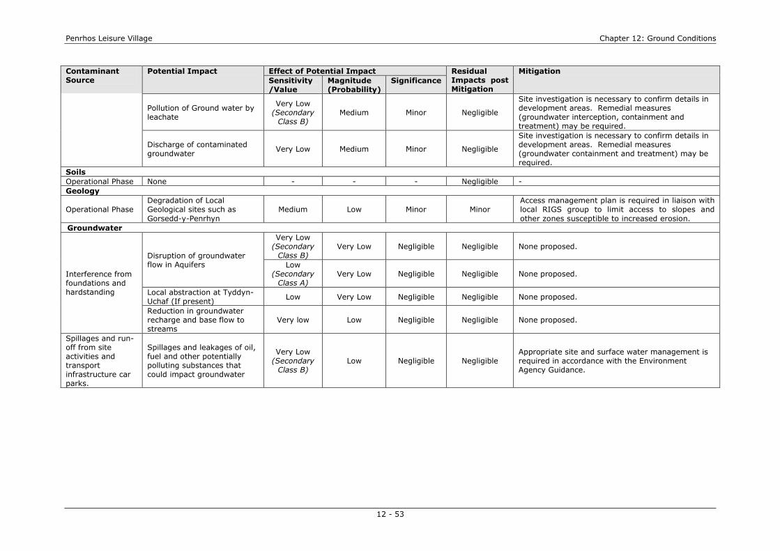
Penrhos Leisure Village Chapter 12: Ground Conditions
12 - 53
Contaminant Source
Potential Impact Effect of Potential Impact Residual Impacts post Mitigation
Mitigation
Sensitivity /Value
Magnitude (Probability)
Significance
Pollution of Ground water by leachate
Very Low (Secondary
Class B) Medium Minor Negligible
Site investigation is necessary to confirm details in development areas. Remedial measures (groundwater interception, containment and treatment) may be required.
Discharge of contaminated groundwater
Very Low Medium Minor Negligible
Site investigation is necessary to confirm details in development areas. Remedial measures (groundwater containment and treatment) may be required.
Soils Operational Phase None - - - Negligible - Geology
Operational Phase Degradation of Local Geological sites such as Gorsedd-y-Penrhyn
Medium Low Minor Minor Access management plan is required in liaison with local RIGS group to limit access to slopes and other zones susceptible to increased erosion.
Groundwater
Interference from foundations and hardstanding
Disruption of groundwater flow in Aquifers
Very Low (Secondary
Class B) Very Low Negligible Negligible None proposed.
Low (Secondary
Class A) Very Low Negligible Negligible None proposed.
Local abstraction at Tyddyn-Uchaf (If present)
Low Very Low Negligible Negligible None proposed.
Reduction in groundwater recharge and base flow to streams
Very low Low Negligible Negligible None proposed.
Spillages and run-off from site activities and transport infrastructure car parks.
Spillages and leakages of oil, fuel and other potentially polluting substances that could impact groundwater
Very Low (Secondary
Class B) Low Negligible Negligible
Appropriate site and surface water management is required in accordance with the Environment Agency Guidance.

Penrhos Leisure Village Chapter 12: Ground Conditions
12 - 54
Table 12.21 Operational Residual Impacts (Contaminated Land)
Contaminant Source
Potential Impact Effect of Potential Impact Residual Impacts post Mitigation
Mitigation
Sensitivity /Value
Magnitude (Probability)
Significance
Contaminated Land; Penrhos Site
Sandpit / Rocky Depression
Adverse impacts on Health of Site users from direct contact, inhalation, ingestion
High Very Low Minor Negligible Site investigation to confirm condition. Removal and of contaminant sources if required.
Adverse impacts on Health of Site users from the migration of ground gas
High Low Moderate Negligible Site investigation to confirm condition and potential for gas generation. Removal and of contaminant sources if required.
Contaminant migration in service runs and impacts on below ground services and groundwater
Low Very Low Negligible Negligible Site investigation to confirm condition. Removal and of contaminant sources if required.
Pollution of controlled surface waters (Pond and Coast) by leachate
Low Low Minor Minor
(Beneficial)
Site investigation to confirm condition. Removal and of contaminant sources if required to provide long term benefit.
Pollution of Groundwater from leachate (Rocky Depression)
Very Low (Secondary
Class B) Very Low Negligible
Negligible (Beneficial)
Site investigation to confirm condition. Removal and of contaminant sources if required.
Pollution of Groundwater from leachate (Sandpit)
Low (Secondary
Class A) Low Minor
Minor (Beneficial)
Site investigation to confirm condition. Removal and of contaminant sources if required to provide long term benefit.
Pet Cemetry
Adverse impacts on Health of Site users from direct contact, inhalation, ingestion
High Very Low Minor Negligible None proposed
Contaminant migration in service runs and impacts on below ground services and groundwater
Low Very Low Negligible Negligible None proposed
Adverse impacts on Health of Site users from the migration of ground gas.
High Low Moderate Negligible Site investigation to confirm condition and potential for gas generation. Mitigation may be required.
Pollution of Groundwater from leachate.
Very Low Very Low Negligible Negligible None proposed
Naturally Occurring CO2
Adverse impacts on Health from migration into buildings
High Very Low Minor Negligible Site investigation required with gas protection measures if necessary.
Naturally Occurring Methane
Adverse impacts on Health from migration into buildings
High Very Low Minor Negligible Mitigation measures required to remove peat deposits for construction if encountered.
Naturally Occurring Radon
Adverse impacts on Health from migration into buildings
High Low Moderate Negligible BR211 Radon report to be obtained from BGS. Gas protection measures may be required

Penrhos Leisure Village Chapter 12: Ground Conditions
12 - 55
Contaminant Source
Potential Impact Effect of Potential Impact Residual Impacts post Mitigation
Mitigation
Sensitivity /Value
Magnitude (Probability)
Significance
AAM & Aluminium Powder Works
Adverse impact on land from lateral migration of contaminants
Low Very Low Negligible Negligible Site investigation required to determine appropriate risk management actions to prevent complete pollutant linkages.
Cae Glas Landfill
Adverse impacts from soils and leachates on site users accessing the landfill area as an amenity
High Low Moderate Negligible Site investigation required to determine appropriate risk management actions to prevent complete pollutant linkages.
Adverse impacts on Health of Site users from the migration of ground gas
High Very Low Minor Negligible The potential for gas migration is considered very low due to distance, nature of soils and geology. Site investigation to confirm.
Adverse impacts on Health of Site users from direct contact, ingestion of migrating leachate
High Very Low Minor Negligible Site investigation required to determine appropriate risk management actions to prevent complete pollutant linkages.
Contaminant migration in service runs and impacts on below ground services and groundwater
Low Very Low Negligible Negligible Site investigation required to determine appropriate risk management actions to prevent complete pollutant linkages.
Pollution of controlled surface waters (Pond) by leachate
Low Very Low Negligible Negligible (Beneficial)
Site investigation required to determine appropriate risk management actions to prevent complete pollutant linkages.
Accumulated Pesticides and herbicides
All receptors Medium Low Minor Negligible Site investigation required to determine appropriate risk management actions to prevent complete pollutant linkages.
Contaminated Land, Kingsland Site
Transformer Oil (PCBs)
Adverse impacts on Health of Site users from direct contact, ingestion of contaminated soils
High Very Low Minor Negligible Access to location needs to be Secure during operation.
Pollution of controlled surface waters (drains) by oil
Very Low Low Negligible Negligible None proposed
Naturally Occurring Radon
Adverse impacts on Health from migration into buildings
High Very Low Minor Negligible BR211 Radon report to be obtained from BGS. Gas protection measures may be required
Porthdafarch Waste Site
All receptors Low Very Low Negligible Negligible None proposed
Pesticides and herbicides
All receptors Medium Low Minor Negligible Site investigation required to determine appropriate risk management actions to prevent complete pollutant linkages.
Contaminated Land; Cae Glas Site
Old Infilled Quarry Adverse impacts on Health of Site Users by direct contact, inhalation, ingestion of soils
High Medium Major Negligible Site investigation and monitoring required to determine appropriate risk management actions to prevent complete pollutant linkages if necessary.

Penrhos Leisure Village Chapter 12: Ground Conditions
12 - 56
Contaminant Source
Potential Impact Effect of Potential Impact Residual Impacts post Mitigation
Mitigation
Sensitivity /Value
Magnitude (Probability)
Significance
Adverse impacts on Health of Site users from the migration of ground gas via ground.
High High Major Negligible
Contaminant migration in service runs and impacts on below ground services
Medium Medium Moderate Negligible
Pollution of constructed pond by leachate migration
Low Low Minor Negligible
Pollution of Ground water by leachate migration
Very Low (Secondary
Class B) Medium Minor
Minor (Beneficial)
Local abstraction at Tyddyn-Uchaf (If present)
Low-Medium Very Low Negligible Negligible
Pollution of controlled waters including local ponds and coastal water by leachate
Low Medium Minor Minor
(Beneficial)
Existing Access Route
Adverse impacts on Health of Site Users by direct contact, inhalation, ingestion
High Very Low Minor Negligible Site investigation required to determine appropriate risk management actions to prevent complete pollutant linkages.
Pollution of Ground water by leachate
Very Low (Secondary
Class A) Low Minor Negligible
Site investigation required to determine appropriate risk management actions to prevent complete pollutant linkages.
Cae Glas Landfill
Adverse impacts on Health of Site Users direct contact, inhalation, ingestion of soils
High High Major Negligible Site investigation required to determine appropriate risk management actions to prevent complete pollutant linkages.
Adverse impacts on Health of Site users from the migration of ground gas
High High Major Negligible
Site investigation required to determine appropriate risk management actions to prevent complete pollutant linkages. Gas monitoring, assessment and mitigation will be required.
Contaminant migration in service runs and impacts on below ground services and groundwater
Medium Medium Moderate Negligible Site investigation required to determine appropriate risk management actions to prevent complete pollutant linkages. Mitigation will be required.
Long Term Pollution of Ground water by leachate
Very Low (Secondary
Class B) High Minor
Negligible (Beneficial)
Contamination of groundwater beneath the landfill site is highly likely. Mitigation measures to address this issue directly are considered impractical but beneficial effects from other actions likely.
Local abstraction at Tyddyn-Uchaf (If present)
Low-Medium Very Low Negligible Negligible The location is a significant distance from the development area. None proposed

Penrhos Leisure Village Chapter 12: Ground Conditions
12 - 57
Contaminant Source
Potential Impact Effect of Potential Impact Residual Impacts post Mitigation
Mitigation
Sensitivity /Value
Magnitude (Probability)
Significance
Long term leachate breakout and pollution of controlled surface waters and SSSI
High Medium Major Major
Beneficial
Site investigation required. Monitoring and treatment measures to address this issue will be required and will therefore have a major beneficial impact.
Pollution of local ponds by leachate
Low Medium Minor Minor
(Beneficial) Site investigation is necessary to confirm. Remedial measures may be required.
Naturally Occurring Radon
Adverse impacts on Health from migration into buildings
High Very Low Minor Negligible BR211 Radon report to be obtained from BGS. Gas protection measures may be required
Pesticides and herbicides
All receptors Medium Low Minor Negligible Site investigation required to determine appropriate risk management actions to prevent complete pollutant linkages.
A55 Trunk Road and Railway land
Adverse impacts on Health of Site Users direct contact, inhalation, ingestion
High Very Low Minor Negligible None proposed, however, scheme design is beneficial
Existing streams and proposed Surface waters
Low Low Minor Negligible (Beneficial)
Site investigation required to assess potential risk.

Penrhos Leisure Village
12 - 58
Conclusions
12.195 The overall findings of the assessment indicate that the scheme will have a
largely negligible impact in terms of Geology, Soils, Groundwater and Contaminated Land with respect to the majority of the elements identified as of concern. However, notable potential specific impacts include:
� Minor long term adverse impacts to the Local Geological site at Gorsedd-y-
Penrhyn;
� Major long term Beneficial Impacts where the scheme addresses current pollution caused by the Cae Glas Landfill to the Beddmanarch-Cymyran SSSI and inland sea; and,
� Minor Beneficial Impacts (subject to site investigation) if the scheme is able
to address pollution issues caused by other areas of fill or contamination.
References � British Geological Survey 1:50,000 Map Sheet 93; Anglesey � British Standards Institute (2007) Code of Practice for the Characterisation and remediation from ground
gas in affected developments. BSI � Capita Symonds Ltd. (2010) Report GC20620/009: Penrhos Nuclear Village Sites. Preliminary Ground
Risk Assessment. Carlisle � Capita Symonds Ltd. (2011) Technical Advice Note: Penrhos Leisure Village Drainage and Flood Risk
Baseline, Opportunities and Constraints. Carlisle. � Capita Symonds Ltd. (2011) Report GC20639/01: Penrhos Leisure Village. Preliminary Sources (Desk)
Study and Ground Risk Assessment. Carlisle. � Capita Symonds Ltd. (2011) Report GC20640/01: Kingsland Leisure Village. Preliminary Sources (Desk)
Study and Ground Risk Assessment. Carlisle. � Capita Symonds Ltd. (2011) Report GC20641/01: Cae Glas Leisure Village. Preliminary Sources (Desk)
Study and Ground Risk Assessment. Carlisle. � Council of the European Union (1975) Council Directive concerning the Quality of Bathing Water
76/160EEC. � Department of the Environment, Food and Rural Affairs (DEFRA) (2010) The River Basin Districts
Typology, Standards and Groundwater Threshold Values (Water Framework Directive) (England and Wales) Directions 2010. HMSO London
� Department of the Environment, Food and Rural Affairs (DEFRA) (2009) Safeguarding our soils. A Strategy for England. DEFRA London
� Department of the Environment, Food and Rural Affairs (DEFRA) (2009) Defra Code of Practice on Sustainable Soils on Construction Sites (2009).
� Department of the Environment, Food and Rural Affairs (DEFRA) (2008) Soil Strategy for England (Draft). HMSO, London
� Department of the Environment, Food and Rural Affairs (DEFRA) (2006) Defra Circular 01/2006, Environmental Protection Act 1990: Part 2A, Contaminated Land.
� Department of the Environment, Food and Rural Affairs (DEFRA) (2006) Local Sites. Guidance on their Identification, Selection and Management. DEFRA London
� Department of the Environment, Food and Rural Affairs (DEFRA) (2004) First Soils Action Plan for England 2004 - 2006. DEFRA London
� Department of the Environment (DOE) (1990) Planning Policy Guidance Note 14. Development on Unstable Ground. DOE London
� Environment Agency (EA) (2011) Response Ein cyf/Our ref: NT/2011/112658/01-L01 � Environment Agency (EA) (2010) Pollution Prevention Guidance (PPG) 6. Working at Construction and
Demolition Sites � Environment Agency (EA) (2008) Groundwater Protection: Policy and Practice (GP3) � Environment Agency (EA) (2001) Pollution Prevention Guidance (PPG) 5. Works or Maintenance near
water. � Environment Agency (EA) (2004). Contaminated Land Report 11 (CLR11), Model Procedures for the
Management of Land Contamination. EA Bristol � Environment Agency (EA) (2001) Pollution Prevention Guidance (PPG) 1. General Guidance to the
Prevention of Pollution � Golder Associates (2008) Phase II Environmental Site Investigation of Cae Glas Landfill, Penrhos,
Holyhead, Anglesey. � Golder Associates (2010) LFG Monitoring and Assessment and updated Risk Assessment. Cae Glas
Landfill, Penrhos, Holyhead, Anglesey.

Penrhos Leisure Village
12 - 59
� Health and Safety Executive (HSE) (2002) Occupational Exposure Limits 2002. HSE Books, Sudbury � Hyder Consulting (2001) Report GD00280/RT/025: A55 Llandegai to Holyhead DBFO Project Geotechnical
Design Report No 4. Inland Sea to Holyhead (39000 – 60400). � Isle of Anglesey County Council (1996) Yns Mon Local Plan. � Isle of Anglesey County Council (2009) Isle of Anglesey AONB Management Plan 2009 - 2014. � Isle of Anglesey County Council (2009) Landscape Strategy Update 2011. � Isle of Anglesey County Council. Guidance on the development of Contaminated Land. � Landmark Reports (2011): 33053063: Site 3 Trearddur; 33052369; Site 1: Kingsland and 33052636: Site
2 Penrhos. � Ministry of Agriculture Fisheries and Food (MAFF) (1988) Agricultural Land Classification of England and
Wales. Revised guidelines and criteria for grading the quality of agricultural land HMSO, London � Ministry of Agriculture Fisheries and Food (MAFF) (2000) Good Practice Guide for Handling Soils by
Machine. HMSO, London � National Soils Resources Institute Soils Site Reports (2010); Report No. 33052636, Penrhos; Report No.
33052639, Kingsland and Report No. 33052063, Trearddur. Cranfield University. � Office of the Deputy Prime Minister (ODPM 06/2005) (DEFRA 01/2005) Biodiversity and Geological
Conservation – Statutory Obligations and their Impact within the Planning System. � PB Power (2009) Environmental Statement – Renewable Energy Plant. � URS Ltd. (2001) Phase 1a site report for IPPC Application – Anglesey Aluminium Facility. � Wallace Evans Ltd (WEL). (1994) Environmental Assessment of the land at Penrhos and Cae Glas Landfill.

`
PENRHOS LEISURE VILLAGE Figure 12.1
Site Constraints April 2012
Pet Cemetery
Rocky Depression
Sand Pit
Anglesey Aluminium Metal
Aluminium Powder Co.
Cae Glas Landfill
A55 / Railway
Gabion Failures
Outfall

Figure 12.2
Kingsland Residential
Village
Site Constraints North
Electricity Sub
Station
Porthdafarch
Waste Site
Area Prone to standing
water

Figure 12.3
Cae Glas Nature Village
Site Constraints
North
In-filled Old Quarry
Old Access Road to Cae Glas Landfill
Cae Glas Landfill
Tidal Flats silt and clay deposits
Potential impacts from highway / rail run-off
Site Boundary
Approximate position of Leachate Breakout
Gas Spike Location SP06 Drainage Flow Direction SP06 Unconfirmed Abstraction