lake st. clair basinwide report - great lakes coastal flood study
TRANSCRIPT

Discovery Report Great Lakes Coastal Flood Study
Lake St. Clair
Basinwide Report Report Number 01 Draft October 2012
DRAFT

Preface
The Department of Homeland Security (DHS), Federal Emergency Management Agency’s (FEMA) Risk Mapping, Assessment, and Planning (Risk MAP) program provides states, tribes, and local communities with flood risk information and tools that they can use to increase their resilience to flooding and better protect their citizens. By pairing accurate floodplain maps with risk assessment tools and planning and outreach support, Risk MAP has transformed traditional flood mapping efforts into an integrated process of identifying, assessing, communicating, planning for, and mitigating flood-related risks.
This lake-wide Discovery Report provides users with a comprehensive and holistic understanding of the historical flood risk, existing coastal data, and current flood mitigation activities within Lake St. Clair. The report includes a summary of the data collected, including information that could influence flood risk decision-making, historical information, existing flood hazard data and information, and mitigation activities. County-based Discovery Reports and data can be found within the appendices of this lake-wide report.
This Discovery Report also provides communities with a summary of FEMA’s intent to proceed with a Risk MAP coastal flood study project based on the data available, data collected, and analysis performed to date.
DRAFT

i Lake St. Clair Discovery Report Draft October 2012
SUBMITTED BY:
125 S. Wacker Drive, Suite 600
Chicago, IL 60606
Date Draft Submitted: October 2012
DRAFT

ii Lake St. Clair Discovery Report Draft October 2012
Project Area Community List for Lake St. Clair
Macomb County St. Clair County Wayne County Macomb County St. Clair County Wayne County Charter Township of Clinton Algonac, City of Detroit, City of Chesterfield, Township of Clay, Township of Grosse Pointe Farms, City of Harrison, Township of Cottrellville, Township of Grosse Pointe Park, City of Mount Clemens, City of East China, Township of Grosse Pointe Shores, Village of New Baltimore, City of Ira, Township of Grosse Pointe Woods, City of St. Clair Shores, City of Marine City, City of Grosse Pointe, City of Marysville, City of Harper Woods, City of Port Huron, City of St. Clair, City of St. Clair, Township of
This list includes all communities within the Lake St. Clair Project Area covered by this report for the Great Lakes Coastal Study under consideration for new Federal Emergency Management Agency (FEMA) Risk Mapping, Assessment, and Planning (Risk MAP) products and datasets, which may include Flood Insurance Studies (FISs) and Flood Insurance Rate Maps (FIRMs). Not all communities will receive new/updated FEMA Risk MAP products and datasets or FISs and FIRMs.
DRAFT

iii Lake St. Clair Discovery Report Draft October 2012
Table of Contents I. Introduction .................................................................................................................. 1
i. Risk MAP Introduction .............................................................................................. 2
ii. Great Lakes Coastal Flood Study ............................................................................... 2
II. Discovery Overview ..................................................................................................... 4 i. Purpose of Lake St. Clair Discovery .......................................................................... 5
III. Stakeholder Communication and Coordination ................................................... 6 i. Lake St. Clair Stakeholder Coordination for Discovery ............................................ 7
IV. Lake St. Clair Discovery Meetings ......................................................................... 8
V. Summary of Data ....................................................................................................... 14 i. New data for Lake St. Clair...................................................................................... 21
I.V.i.1 Oblique Imagery............................................................................................... 21 I.V.i.2 Topography and Bathymetry ........................................................................... 21 I.V.i.3 Shoreline Feature Dataset ................................................................................ 23 I.V.i.4 Proposed Draft Transects ................................................................................. 24 I.V.i.5 Storm Surge and Wave Study .......................................................................... 24
VI. Lake-wide Issues and Long-term Trends ............................................................ 24 i. Water Levels ............................................................................................................ 26
ii. Historical Flooding & High Water Marks ............................................................... 30
iii. Coastal Flood Protection Measures .......................................................................... 33
iv. Coastal Recession .................................................................................................... 38
VII. Hazard Mitigation Resources, Strategies, and Actions ...................................... 39 i. Hazard Mitigation Overview ................................................................................... 39
ii. The Mitigation Action Form and Action Tracker .................................................... 43 I.VII.ii.1 Types of Mitigation Actions ........................................................................ 45
iii. Hazard Mitigation Programs and Assistance ........................................................... 46
VIII. Risk MAP Projects and Needs .............................................................................. 50 i. Future Coastal Study ................................................................................................ 50
I.VIII.i.1 Engineering and Mapping ............................................................................ 51 I.VIII.i.2 National Flood Insurance Program Data Integration ................................... 52 I.VIII.i.3 Risk Assessment Product Development....................................................... 53
DRAFT

iv Lake St. Clair Discovery Report Draft October 2012
Table of Contents - continued
ii. Potential for Mitigation Assistance .......................................................................... 55
iii. Compliance .............................................................................................................. 56 I.VIII.iii.1 Coastal Special Flood Hazard Areas (SFHAs) .......................................... 57 I.VIII.iii.2 Building Requirements in VE Zones ......................................................... 58 I.VIII.iii.3 Limit of Moderate Wave Action (LiMWA) .............................................. 58
iv. Communication ........................................................................................................ 62
v. Unmet Needs ............................................................................................................ 62
IX. Close ........................................................................................................................ 63
X. References ................................................................................................................... 64
XI. Appendices .............................................................................................................. 65
DRAFT

v Lake St. Clair Discovery Report Draft October 2012
Table of Contents - continued List of Figures Figure 1: Flooding at Anchor Bay, Lake St. Clair, MI ......................................................... 1 Figure 2: Great Lakes Basin Overview ................................................................................. 3 Figure 3: Discovery Process Overview ................................................................................. 5 Figure 4: Discovery Meeting Overview ................................................................................ 9 Figure 5: Sample Proposed Transect Figure (from Discovery Meeting) ............................ 12 Figure 6: Historic Great Lakes Water Levels from 1918 to 2011 ....................................... 29 Figure 7: Lake St. Clair Shoreline Material and Coastal Structures ................................... 37 Figure 8: Hazard Mitigation ................................................................................................ 41 Figure 9: LiMWA ............................................................................................................... 59
List of Tables Table 1: Stakeholder General Comments and Transect Comments Collected During Discovery Meetings ............................................................................................................. 13 Table 2: Data Collected for Lake St. Clair ........................................................................... 14 Table 3: Coastal Data Request Form Data Compilation – 3pgs .......................................... 18 Table 4: High Water Marks ................................................................................................. 32 Table 5: USACE Coastal Inventory Database ..................................................................... 36 Table 6: Hazard Mitigation Plan Status ............................................................................... 40 Table 7: Summary of Potential Mitigation Actions and Strategies ...................................... 42 Table 8: FEMA Hazard Mitigation Assistance (HMA) Program ........................................ 47 Table 9: Other Agency Mitigation Program and Assistance .............................................. 48 Table 10: Potential Flood Risk Products for Lake St. Clair ................................................ 53
Appendices Appendix A: Lake St. Clair Stakeholder List Appendix B: Coastal Data Request Form Appendix C: Macomb County Discovery Report (with attachments) Appendix D: St. Clair County Discovery Report (with attachments) Appendix E: Wayne County Discovery Report (with attachments) Appendix F: Final Discovery Maps Appendix G: High-Risk Erosion Figures (MDEQ) Appendix H: Mitigation Action Form (condensed)
DRAFT

vi Lake St. Clair Discovery Report Draft October 2012
Acronyms and Abbreviations
AAL Average Annualized Loss CAV Community Assistance Visit CBRS Coastal Barrier Resources System CID Community Identification Number CIS Community Information System CMAG Coastal Management Assistance Grant C-MAN Coastal Marine Automated Network CNMS Coordinated Needs Management Strategy CO-OPS Center for Operational Oceanographic Products and Services CRS Community Rating System DFO Department of Fisheries and Oceans FEMA Federal Emergency Management Agency FIPS Federal Information Processing Standards FIRM Flood Insurance Rate Map FIS Flood Insurance Study GLCF Great Lakes Coastal Flood Study GLCRG Great Lakes Coastal Restoration Grant Hazus-MH Multi-Hazard Risk Assessment and Loss Estimation Software
Program HWM High Water Mark HUC8 Hydrologic Unit Code 8 LOMA Letter of Map Amendment LOMC Letter of Map Change LOMR Letter of Map Revision LOMR-F Letter of Map Revision based on Fill MLI Midterm Levee Inventory NDBC National Data Buoy Center
NFIP National Flood Insurance Program NGDC National Geophysical Data Center NID National Inventory of Dams NOAA National Oceanic and Atmospheric Administration
NWS National Weather Service Risk MAP Risk Mapping, Assessment, and Planning SFHA Special Flood Hazard Area USACE U.S. Army Corps of Engineers
USGS U.S. Geological Survey
DRAFT

1 Lake St. Clair Discovery Report Draft October 2012
I. Introduction The intent of this report is to provide users with a comprehensive and holistic understanding of historical coastal flood risk, existing coastal data, and current activities underway to mitigate coastal flood risk within the Lake St. Clair basin. In other words, help users discover the current and historic state of the Lake St. Clair basin as it relates to coastal flood risk and mitigation activities. This report includes a summary of data collected from Lake St. Clair stakeholders throughout the discovery process, as well as a compilation of Lake St. Clair long-term issues and trends as it relates coastal flooding. This report also provides users with information about the intent to move forward with a new coastal flood risk study along the Lake St. Clair shoreline as part of the Great Lakes Coastal Flood Study initiative. An updated coastal flood study is needed to obtain a better estimate of coastal flood hazards on Lake St. Clair. Historically, Lake St. Clair flooding is generally not the result of a single storm event, but rather it is the result of a series of contributing factors, such as wind speed and lake water level. In addition, the general desire to live along the Lake St. Clair shoreline has concentrated development and consequently increased potential flooding damage.
The most damaging flooding has occurred along the Lake St. Clair coast in 1973, 1985, and 1986. Storms on March 31, 1985, and April 4 and 6, 1985, with high easterly and northeasterly winds, drove the already high waters of Lake St. Clair on shore, inundating portions of all the coastal communities around the Lake. Much of the damage along Lake St. Clair shorelines has been caused by water flowing through gaps in dikes built under USACE’s Operation Foresight in 1973-1974, which were subsequently lowered or removed in the late 1970's by some residents to facilitate access to Lake St. Clair. Figure 1 provides an example of flooding that occurred at Anchor Bay on March 28, 1986. The subsection below outlines the Federal Emergency Management Agency (FEMA) program, Risk Mapping, Assessment, and Planning (Risk MAP), under which the new coastal flood study will be performed.
Figure 1: Flooding at Anchor Bay, Lake St. Clair, MIPhotograph taken by: Carol Swinehard, Michigan Sea Grant Extension March 28, 1986

2 Lake St. Clair Discovery Report Draft October 2012
i. Risk MAP Introduction Risk Mapping, Assessment, and Planning (Risk MAP) is a FEMA program that provides communities with flood information and tools they can use to enhance their mitigation plans and better protect their citizens against flood hazards. Through more accurate flood maps, risk assessment tools, and outreach support, Risk MAP strengthens local ability to make informed decisions about reducing flood risk. Through collaboration with State, Local, and Tribal entities, Risk MAP will deliver quality data that increases public awareness and leads to action that reduces risk to life and property. The intention of FEMA is to collaborate with Federal, State, and local stakeholders to achieve the following goals: • Address gaps in flood hazard data to form a
solid foundation for risk assessment and floodplain management.
• Ensure that a measurable increase of the public’s awareness and understanding of risk results in a measurable reduction of current and future vulnerability.
• Lead and support States, local, and Tribal communities to effectively engage in risk-based mitigation planning resulting in sustainable actions that reduce or eliminate risks to life and property from natural hazards.
• Provide an enhanced digital platform that improves management of Risk MAP, stores information produced by Risk MAP, and improves communication and sharing of risk data and related products to all levels of government and the public.
• Align programs and develop synergies to enhance decision-making capabilities through effective risk communication and management.
ii. Great Lakes Coastal Flood Study FEMA, through the Risk MAP program and in cooperation with the U.S. Army Corps of Engineers (USACE), the Association of State Floodplain Managers (ASFPM), and other partners, is conducting a comprehensive study of flood hazard for all United
DRAFT
3 Lake St. Clair Discovery Report Draft October 2012
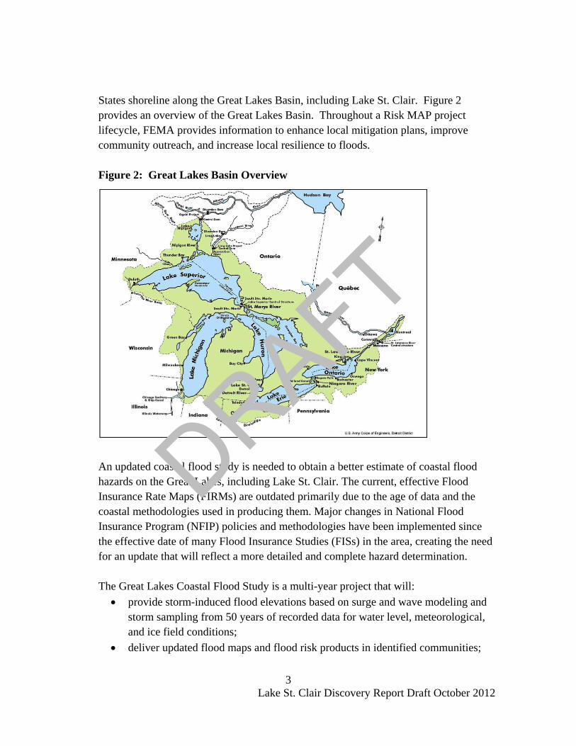
States shoreline along the Great Lakes Basin, including Lake St. Clair. Figure 2 provides an overview of the Great Lakes Basin. Throughout a Risk MAP project lifecycle, FEMA provides information to enhance local mitigation plans, improve community outreach, and increase local resilience to floods. Figure 2: Great Lakes Basin Overview
An updated coastal flood study is needed to obtain a better estimate of coastal flood hazards on the Great Lakes, including Lake St. Clair. The current, effective Flood Insurance Rate Maps (FIRMs) are outdated primarily due to the age of data and the coastal methodologies used in producing them. Major changes in National Flood Insurance Program (NFIP) policies and methodologies have been implemented since the effective date of many Flood Insurance Studies (FISs) in the area, creating the need for an update that will reflect a more detailed and complete hazard determination. The Great Lakes Coastal Flood Study is a multi-year project that will:
• provide storm-induced flood elevations based on surge and wave modeling and storm sampling from 50 years of recorded data for water level, meteorological, and ice field conditions;
• deliver updated flood maps and flood risk products in identified communities;
DRAFT

4 Lake St. Clair Discovery Report Draft October 2012
• provide oblique photos, high-resolution bathymetry, geospatial inventory of coastal land features and structures, and other coastal data to advance local, State, and Federal capability in public safety, hazard mitigation, and asset management initiatives; and
• enhance local planning processes The Great Lakes Coastal Flood Study includes a system-wide solution that provides a comprehensive analysis of storm and high water events within the Great Lakes Basin. FEMA, USACE, ASFPM, State partners, and FEMA contractors will collaborate in updating the coastal methodology and flood maps, and create new flood risk products. FEMA manages the NFIP, which is the cornerstone of the national strategy for preparing communities for flood-related disasters. The Great Lakes Coastal Flood Study will incorporate modern analysis of historic storm and high water events and provide for updated flood risk information serving United States communities having shoreline along the Great Lakes. The storm surge study is one of the most extensive coastal storm surge analyses to date, encompassing coastal floodplains in the eight States with coastlines on the Great Lakes. The new coastal flood hazard analyses will utilize updated 1-percent-annual-chance (100-year) flood elevations obtained from the comprehensive storm surge study being developed by the USACE Each Risk MAP project, including the Great Lakes Coastal Flood Study, begins with a Discovery phase. Section II of this report provides a Discovery overview.
II. Discovery Overview Prior to moving forward with a Risk MAP project, FEMA conducts a process called Discovery. During the Discovery phase, FEMA:
• Gathers information about local flood risk and flood hazards • Reviews mitigation plans to understand local mitigation capabilities, hazard risk
assessments, and current or future mitigation activities • Supports communities within the project area to develop a vision for the future • Collects information from communities about their flooding history, development
plans, daily operations, and stormwater and floodplain management activities • Uses all information gathered to determine which areas require mapping, risk
assessment, or mitigation planning assistance through a Risk MAP project
DRAFT
5 Lake St. Clair Discovery Report Draft October 2012
• Develops a Discovery Map and Report that summarizes and displays the Discovery findings
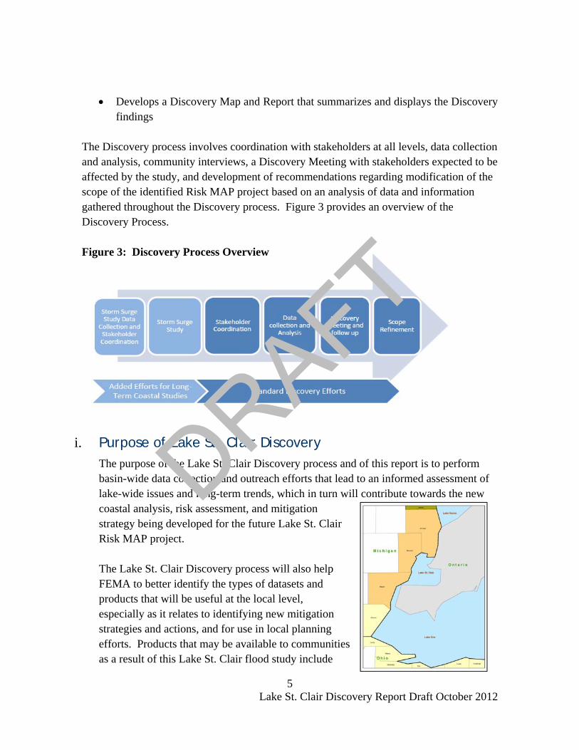
The Discovery process involves coordination with stakeholders at all levels, data collection and analysis, community interviews, a Discovery Meeting with stakeholders expected to be affected by the study, and development of recommendations regarding modification of the scope of the identified Risk MAP project based on an analysis of data and information gathered throughout the Discovery process. Figure 3 provides an overview of the Discovery Process.
Figure 3: Discovery Process Overview
i. Purpose of Lake St. Clair Discovery The purpose of the Lake St. Clair Discovery process and of this report is to perform basin-wide data collection and outreach efforts that lead to an informed assessment of lake-wide issues and long-term trends, which in turn will contribute towards the new coastal analysis, risk assessment, and mitigation strategy being developed for the future Lake St. Clair Risk MAP project. The Lake St. Clair Discovery process will also help FEMA to better identify the types of datasets and products that will be useful at the local level, especially as it relates to identifying new mitigation strategies and actions, and for use in local planning efforts. Products that may be available to communities as a result of this Lake St. Clair flood study include
DRAFT

6 Lake St. Clair Discovery Report Draft October 2012
updated FIRMs and FIS, coastal flood risk products, calibrated models for storm surge and wave analysis, and accurate depictions of water level and wave response of the lake occurring during hundreds of actual events. The type of product a community will receive during a Risk MAP study is dependant not only on the coastal flood study analysis results, but also on the type of data, local or national, that is available. The Lake St. Clair Discovery process included tabular and spatial data collection, information exchange between all governmental levels of stakeholders, cooperative discussion with stakeholders to better understand the Lake St. Clair area, and a collaborative approach on the project planning. This process has allowed FEMA to continue to vet the Great Lakes coastal study methodologies with a large stakeholder group, to discuss local priorities and data, to discuss mitigation strategies and coastal issues, and to move towards a project that will successfully identify the risks associated with Lake St. Clair flooding. The results of this Discovery process and next steps for the Lake St. Clair coastal flood study project are discussed in the remaining sections of this report.
III. Stakeholder Communication and Coordination Communication and coordination with Federal, State, and local stakeholders is key to the success of the Great Lakes Coastal Flood Study (GLCFS). A large emphasis has been placed on identifying stakeholders early and often and working with those stakeholders continually throughout the study process, from Discovery all the way through flood map and flood risk product development. Through outreach, the goal is to increase understanding of the new coastal study methodologies and the tools and processes that will be available for risk-based community planning, and to increase flood hazard awareness within the Great Lakes Coastal Region. Throughout this GLCFS process, FEMA will seek to identify partnerships with stakeholders early and often. Through coordination with stakeholders, identification of local flood hazards, data, and mitigation needs will help FEMA to better understand types of flood risk products that may be beneficial to communities as they seek to better protect and inform their citizens against flood hazards. Additional information about the coastal flood risk products that may be available to communities as a result of this study can be found in the county-based reports, under the “Coastal Flood Risk Products” section, in Appendices C (Macomb County), D (St. Clair County), and E (Wayne County) of this report.
DRAFT

7 Lake St. Clair Discovery Report Draft October 2012
i. Lake St. Clair Stakeholder Coordination for Discovery Meetings, emails, telephone calls, and letters are essential to communicate effectively throughout the life of this Lake St. Clair Coastal Flood Study project, which has begun with this Discovery process. A master list of stakeholders within the project area covered by this Discovery Report (Lake St. Clair) has been established as part of Discovery and is included in Appendix A. FEMA will continuously update this list throughout the life of this project. To kick-off this Discovery process, FEMA formed a group of core stakeholders, which included representatives from FEMA Region V, STARR (mapping partner to FEMA), USACE, NOAA, ASFPM, the State NFIP Coordinator, the State Hazard Mitigation Officer (SHMO), and State Engineers. The core stakeholders reviewed the Discovery plan, objectives, and key outcomes for Lake St. Clair Discovery with FEMA, provided suggestions for outreach and communication, and raised any concerns as it related to Lake St. Clair and the coastal flood study process. Following this kick-off process, outreach, communication, and coordination with local stakeholders was initiated. Three Discovery Meetings were held for the Lake St. Clair project area. Discovery Meeting invitations were sent to local stakeholders within the St. Clair, Macomb, and Wayne County portions of the Lake St. Clair Coastal Flood Study project. In addition, an email invitation was sent to a larger list of stakeholders including, but not limited to, the core stakeholder group, other federal agencies, universities, watershed groups, Great Lakes associations, technical stakeholders, and emergency management agencies. Representatives from the local governments, including cities, townships, and villages were considered fundamental stakeholders in this process because they have been elected or appointed to represent the interests of the residents of the project area. The Discovery Meeting invitations included a Coastal Data Request Form, which can be found in Appendix B following this report. The form requested communities provide information on data that they had available at the local level that may be of use during the flood study update and during the development of the coastal flood risk products discussed earlier in this report.
DRAFT

8 Lake St. Clair Discovery Report Draft October 2012
The Coastal Data Request Form listed requests for information and data, including: • Base map data • Coastal data • Historic flood data • Risk assessment • Flood mitigation information • Community plans and projects • Other comments/concerns based on local knowledge
A summary of the data and information collected via the completed Coastal Data Request Forms can be found in Section V, Summary of Data, of this report, and also in the county-based Discovery Reports found in Appendices C (Macomb County), D (St. Clair County), and E (Wayne County). In addition to the hard copy letter invitations, and in order to improve the communication and data sharing leading up to the Discovery Meeting, FEMA offered local communities an opportunity to attend pre-Discovery Meeting conference calls, also termed “Information Exchange Sessions”. The conference call information was included in the Discovery invitation letters mailed to local community officials, and an email reminder was sent out as well. The session’s intent was to begin the process of learning about local data availability and what the critical issues are for the communities, and to review the Coastal Data Request Form. Meeting minutes and a copy of the presentations from the Information Exchange Session conference calls can be found in Appendices C, D and E, the county-based Discovery Reports. The Discovery Meetings are discussed in greater detail in the next section of this report.
IV. Lake St. Clair Discovery Meetings The Discovery Meetings for Lake St. Clair coastal communities and stakeholders were held on the following dates:
• Macomb County: Monday, August 20, 2012, 2-4pm ET in Clinton Township, Michigan
• St. Clair County: Monday, August 20, 2012, 8:30-11:30am ET in Goodells, Michigan
• Wayne County: Tuesday, August 21, 2012, 2-4pm ET in Grosse Pointe Park, Michigan
DRAFT

9 Lake St. Clair Discovery Report Draft October 2012
Communities and stakeholders affected by coastal flooding in Macomb, St. Clair, and Wayne Counties were invited to the Discovery Meetings. The figure below depicts the location of the Discovery Meetings in Lake St. Clair basin. Figure 4: Discovery Meeting Overview
DRAFT

10 Lake St. Clair Discovery Report Draft October 2012
Below is a summary of the stakeholders in attendance: • Attendees included, but were not limited to, planners, engineers, GIS Specialists,
natural hazard program specialists, educators, building inspectors, and conservation agents.
• Out of the 23 coastal communities included in this study area, seven (7) were represented at one (1) of the three (3) Discovery Meetings.
• In total, the meetings were represented by 39% community officials, 21% county officials, 11% local engineering firms, 8% State officials, 7% academia community, 7% community members and associations, and 7% from the Air National Guard.
Sign-in sheets for each meeting can be found within the county-based Discovery Reports found in Appendices C (Macomb County), D (St. Clair County), and E (Wayne County). All stakeholders listed in Appendix A, Lake St. Clair Stakeholder List, were invited to attend these Discovery Meetings either via email or hard copy letter. Copies of the invitations, along with County-specific contact lists, can be found in within the county-based reports in Appendices C, D, and E. The objectives of the Discovery Meetings included:
• Continuation and expansion upon stakeholder engagement • Discussion of data inputs from Federal, state, and local stakeholders • Identification of local coastal flood hazard needs and areas of concern • Identification of flood risk products and datasets that best advance coastal
mitigation action • National Flood Insurance Program (NFIP) regulatory updates • Discovery schedule and deliverables
The Discovery Meeting presentations included the following information:
• An overview of the GLCFS and schedule • Review of the Discovery process and outcomes • Discussion of coastal mapping and flood risk topics to be aware of • Discussion of how the study may affect the communities, including compliance
requirements • Review of hazard mitigation opportunities and grant funding • Encouragement and facilitation discussion regarding coastal study needs,
mitigation project needs, desired compliance support, and local flood risk awareness efforts.
DRAFT

11 Lake St. Clair Discovery Report Draft October 2012
Draft Discovery Maps (found in Attachments within county-based reports in Appendices C, D, and E) were displayed and utilized during the meeting to stimulate the discussion regarding areas of coastal flood risk concern and areas of mitigation interest (AoMI). The draft Discovery Maps shown at the meetings included geospatial and tabular data that had been collected prior to the meetings: Geospatial Data:
• Average Annualized Loss (AAL) data • Coastal Barrier Resources System (CBRS1
) • Coordinated Needs Management Strategy (CNMS2
) Data (riverine only) • Proposed Transects • Effective Special Flood Hazard Areas (SFHAs) • Jurisdictional Boundaries • Letters of Map Change (LOMCs) • Levees • Shoreline • Streams • USGS Gages • Watershed Boundaries
Tabular Data:
• Declared Disasters • Flood Insurance Data • Potential Mitigation Actions (from local Hazard Mitigation Plans) • Summary of Shoreline Data (Type and Material)
Attendees were asked to cooperatively identify Areas of Concern and Areas of Mitigation Interest (AoMIs) within the Lake St. Clair study area using the draft Discovery Map
1 CBRS consists of the undeveloped coastal barriers and other areas located on the coasts of the United States that are identified and generally depicted on a series of maps. CBRS areas are ineligible for most new Federal expenditures and financial assistance. 2 CNMS is a FEMA initiative to update the way FEMA organizes, stores, and analyzes flood hazard mapping needs information for communities. CNMS defines an approach and structure for the identification and management of flood hazard mapping needs that provides support to data-driven planning and the flood map update investment process in a geospatial environment. CNMS makes information related to mapping needs readily accessible and more usable. Currently, CNMS only captures riverine needs. It is expected coastal needs will be captured in this system in the future.
DRAFT

12 Lake St. Clair Discovery Report Draft October 2012
(Attachments within Appendices C, D, and E) and through general discussion during the meeting. In addition to the draft Discovery Maps, figures showing the location of initially proposed transects around Lake St. Clair were available for review and comment immediately following the meetings. Stakeholders were encouraged to review the proposed transects and provide comments related to the location and orientation of transects. The proposed transect maps that were available at the Discovery Meeting can be found as attachments in the county-based reports located in Appendices C, D, and E. A sample map is shown below as Figure 5. Users should note that transects have since been revised and should refer to the updated proposed transect locations found on the Final Discovery Maps (Appendix F). Figure 5: Sample Proposed Transect Figure (from Discovery Meeting)
DRAFT

13 Lake St. Clair Discovery Report Draft October 2012
All comments that were provided during these meetings on the draft Discovery Maps and transect figures have been compiled into geospatial layers and associated tables. The layers, titled “Stakeholder General Comments” and “Stakeholder Transect Comments”, can be found on the Final Discovery Maps in Appendix F. A list of each comment collected for all Lake St. Clair counties is listed below, along with a map identification number (if one exists), which correlates to its location on the Final Discovery Maps (Appendix F). A summary and analysis of the comments collected by county can be found in the individual county-based reports for Macomb County, St. Clair County, and Wayne County, located in Appendix C, D, and E, respectively, of this report.
Table 1: Stakeholder General Comments and Transect Comments Collected During Discovery Meetings
ID (See Final Discovery Map) County
Location of Comment FIPS CID Comment
MAC-1 Macomb Township of Harrison 26099 N/A To be developed
MAC-2, MAC-TR-1, and MAC-TR-2 Macomb
Township of Harrison 26099 260123
User indicated suggested transect location; sloping rock wall; to be developed
MAC-3 Macomb City of St. Clair Shores 26099 260127
User indicated suggested transect location; Critical lift facility - Critical Facility
WAY-4 Wayne City of Detroit 26163 260222
Water Works Park - Critical Facility; Transect suggested at Water Works Park along Detroit River
WAY-TR-4 Wayne
Belle Isle, City of Detroit 26163 260222
Transect suggested for the eastern tip of Belle Isle
N/A All
Macomb, St. Clair, and Wayne Counties
26099, 26147, 26163 N/A
Requested the effective transects be used for Lake St Clair
FIPS = Federal Information Processing Standards CID = Community Identification Number
DRAFT

14 Lake St. Clair Discovery Report Draft October 2012
Discovery Meeting documents, including meeting minutes, sign in sheets, presentations, coastal data request forms, and correspondence documentation, have been included in the attachments for each county-level Discovery Report, found in Appendices C (Macomb County), D (St. Clair County), and E (Wayne County).
V. Summary of Data This section summarizes the data and information collected for Lake St. Clair during this Discovery process. During the Discovery portion of the Lake St. Clair Coastal Flood Study project, a massive collection of tabular and spatial data was conducted for all the coastal communities from Federal, State, and local sources. In addition, information was collected through phone conversations, information exchange session conference calls, the Discovery Meetings, and the Discovery Coastal Data Request forms sent to each coastal community. The below table is a comprehensive list of all the types of data and their sources that were collected for this Lake St. Clair study area. Table 2: Data Collected for Lake St. Clair
Data Types Deliverable/Product Source Date of
Data Collection
Level
Average Annualized Loss
Data (AAL)
Discovery Map/Tabular Data
Federal Emergency Management Agency (FEMA) June 2012 Nationwide
Bathymetry and Topography Discovery Report USACE 2012 Lakewide
Census Blocks Discovery Map/Tabular Data U.S. Census Bureau June 2012 Countywide
Coastal Data Request Form
Discovery Report/Tabular Data
Community and County Stakeholders July 2012 Countywide
Contacts Discovery Report/Tabular Data
Local Community Websites,
State/FEMA updates June 2012 Countywide
Community Assistance Visits
(CAVs)
Discovery Report/Tabular Data
FEMA Community Information System (CIS) July 2012 Countywide
DRAFT

15 Lake St. Clair Discovery Report Draft October 2012
Data Types Deliverable/Product Source Date of
Data Collection
Level
Community Rating System
(CRS)
Discovery Report/Tabular Data
FEMA’s “Community Rating System
Communities and Their Classes”
July 2012 Nationwide
Comprehensive Plans Discovery Report Local Community
Websites July 2012 Countywide
Coastal Barrier Resources
System (CBRS) Discovery Map U.S. Fish and Wildlife
Service July 2012 Nationwide
Coastal Structures
Discovery Map/Tabular Data
U.S. Army Corps of Engineers (USACE)
August 2012 Nationwide
Coordinated Needs
Management Strategy (CNMS)
– riverine only
Discovery Map FEMA July 2012 Countywide
Critically Erosion Beach
Areas None Identified None Identified N/A Countywide
Critical Facilities Discovery Report/Discovery Map
Local Mitigation Plan, Discovery Meeting July 2012 Countywide
Dams Discovery Map/Tabular Data
USACE, National Inventory of
Dams, Flood Insurance Rate
Map (FIRM) Database
July 2012 Countywide
Declared Disasters
Discovery Report/Tabular Data
FEMA’s “Disaster Declarations Summary” June 2012 Nationwide
Demographics, Industry
Discovery Report/Tabular Data
U.S. Census Bureau, Local Mitigation Plans June 2012 Countywide
Effective Floodplains Discovery Map
FEMA Map Service Center and Mapping Information Platform
June 2012 Countywide
Hazard Mitigation Plans
and Status
Discovery Report/Tabular Data Local Mitigation Plans July 2012 Countywide
DRAFT

16 Lake St. Clair Discovery Report Draft October 2012
Data Types Deliverable/Product Source Date of
Data Collection
Level
Hazard Mitigation Assistance
Program Grants Received
Discovery Report/Tabular Data
FEMA’s “Hazard Mitigation Program
Summary” Community Input
June 2012 Nationwide
Hazard Mitigation
Projects
Discovery Report/Tabular Data Local Mitigation Plans July 2012 Countywide
High Water Marks
Discovery Report, Tabular Data
Effective Flood Insurance Study (FIS)
August 2012 Countywide
Historical Flooding &
Storm Events Discovery Report
Effective Flood Insurance Study (FIS),
Local Mitigation Plans July 2012 Countywide
Individual/Public Assistance
Discovery Report/Tabular Data
FEMA’s “Public Assistance Subgrantee
Summary” June 2012 Nationwide
Insurance Policies
Discovery Report/Tabular Data FEMA CIS July 2012 Nationwide
Letters of Map Change
(LOMCs)
Discovery Map/Tabular Data
FEMA’s Mapping Information Platform July 2012 Countywide
Meteorological Gages
Discovery Map/Tabular Data
National Oceanic and Atmospheric
Administration (NOAA) Great Lakes
Environmental Research Laboratory
July 2012 Regionwide
Oblique Imagery Discovery Report USACE 2012 Lakewide
Ordinance Status Discovery Report/Tabular Data FEMA CIS July 2012 Countywide
Repetitive Loss Discovery Report/Tabular Data FEMA CIS July 2012 Countywide
Shoreline Classification
Discovery Map/Tabular Data USACE July 2012 Regionwide
DRAFT

17 Lake St. Clair Discovery Report Draft October 2012
Data Types Deliverable/Product Source Date of
Data Collection
Level
Stream Gages Discovery Map/Tabular Data USGS July 2012 Countywide
Water Level Gages
Discovery Map/Tabular Data
NOAA Department of Fisheriesand Oceans July 2012 Regionwide
Wave Gages Discovery Map/Tabular Data NOAA July 2012 Regionwide
Information and data collected for each county along Lake St. Clair has been compiled into county-level Discovery Reports and can be found in Appendices C (Macomb County), D (St. Clair County), and E (Wayne County) of this report. The data in the county reports are divided into two sections: one section listing the data that can be used for Risk MAP products and the other section listing the information that helped the study team to form a better understanding of the Lake St. Clair Project Area prior to moving forward with the Great Lakes Coastal Flood Study. A list of local data and information collected from local stakeholders as part of this Discovery process through the Coastal Data Request Form (Appendix B) has been compiled for Lake St. Clair in Table 3.
DRAFT

Table 3. Lake St. Clair Local Data CollectionBase Map Data, Coastal Data, Other Data, and Historical Flood Data
HISTORICAL FLOOD DATA
Community, County or State Organization County State Topography
Property Information (Building Footprints, Parcel Data, Tax Assessor's Data)
Coastal Structure Inventory (Seawalls, Jetties, etc)
Coastal Feature Inventory (dunes, bluffs, etc)
Shoreline Change Data
Locations of beach nourishment or dune restoration projects
Areas of significant beach or dune erosion
Mean high water
Mean lake level
Hydraulic Structures (i.e. bridges, culverts, levees, dams) with inspection status, if available
Elevated roads
Critical Facilities
Other known hazards with geographical boundaries, i.e., landslide hazard areas, storm surge inundation zones, wildfire hazard areas, etc.
Other relevant data
Are you aware of any coastal flooding issues not represented on effective FIRMs:
Charter Township of Clinton Macomb MI No
Macomb County Office of Emergency Management Macomb MI Digital Digital No
Southeast Michigan Council of Governments (SEMCOG) SEMCOG MI
LiDAR & Contour data
Building footprints
City of Grosse Pointe Woods Wayne MI No
City of Harper Woods Wayne MI
Available through Wayne County
Available through Wayne County No
BASE MAP DATA COASTAL DATA OTHER DATA
DRAFT
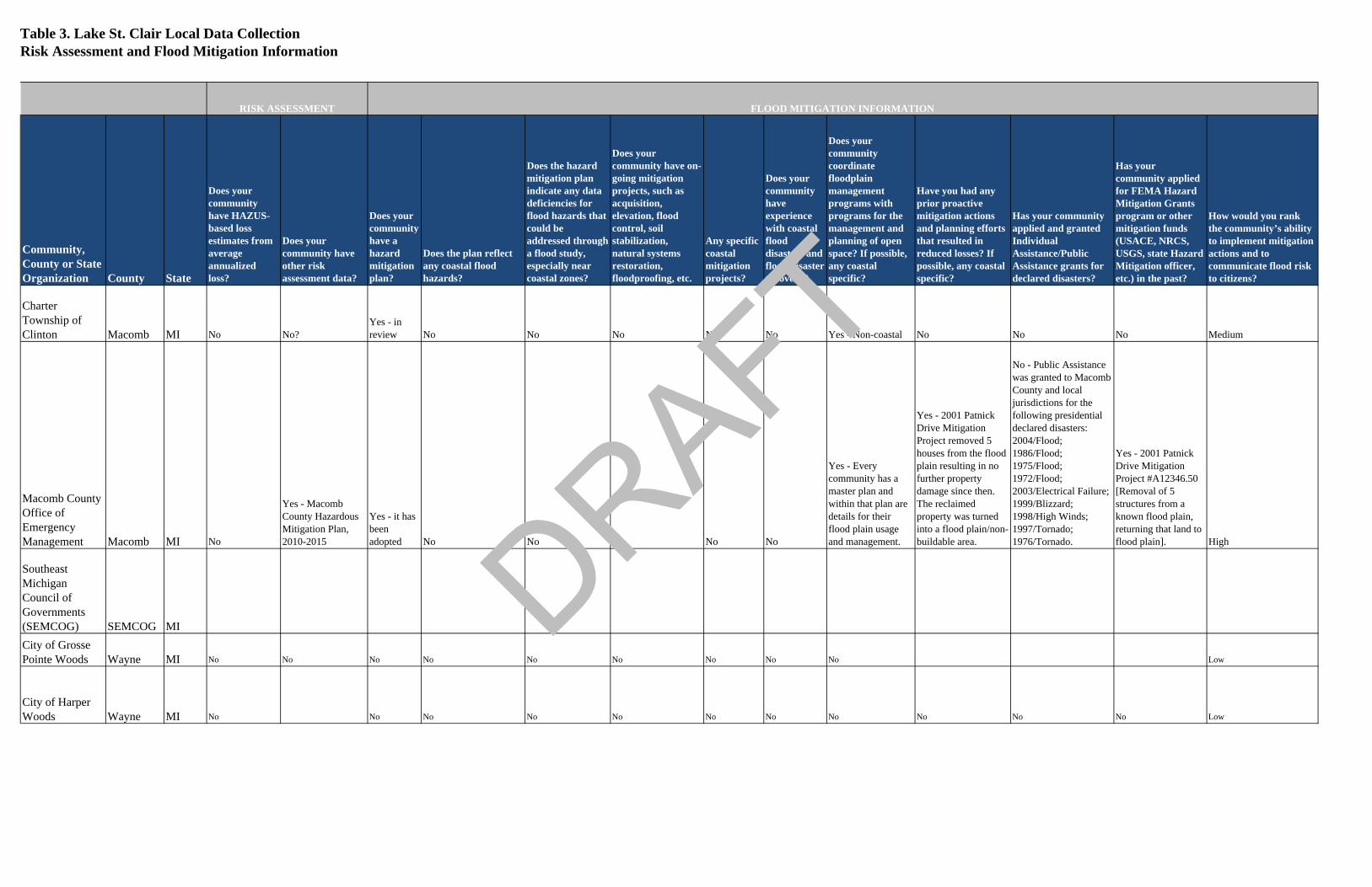
Table 3. Lake St. Clair Local Data CollectionRisk Assessment and Flood Mitigation Information
Community, County or State Organization County State
Does your community have HAZUS-based loss estimates from average annualized loss?
Does your community have other risk assessment data?
Does your community have a hazard mitigation plan?
Does the plan reflect any coastal flood hazards?
Does the hazard mitigation plan indicate any data deficiencies for flood hazards that could be addressed through a flood study, especially near coastal zones?
Does your community have on-going mitigation projects, such as acquisition, elevation, flood control, soil stabilization, natural systems restoration, floodproofing, etc.
Any specific coastal mitigation projects?
Does your community have experience with coastal flood disasters and flood disaster recovery?
Does your community coordinate floodplain management programs with programs for the management and planning of open space? If possible, any coastal specific?
Have you had any prior proactive mitigation actions and planning efforts that resulted in reduced losses? If possible, any coastal specific?
Has your community applied and granted Individual Assistance/Public Assistance grants for declared disasters?
Has your community applied for FEMA Hazard Mitigation Grants program or other mitigation funds (USACE, NRCS, USGS, state Hazard Mitigation officer, etc.) in the past?
How would you rank the community’s ability to implement mitigation actions and to communicate flood risk to citizens?
Charter Township of Clinton Macomb MI No No?
Yes - in review No No No No No Yes - Non-coastal No No No Medium
Macomb County Office of Emergency Management Macomb MI No
Yes - Macomb County Hazardous Mitigation Plan, 2010-2015
Yes - it has been adopted No No No No No
Yes - Every community has a master plan and within that plan are details for their flood plain usage and management.
Yes - 2001 Patnick Drive Mitigation Project removed 5 houses from the flood plain resulting in no further property damage since then. The reclaimed property was turned into a flood plain/non-buildable area.
No - Public Assistance was granted to Macomb County and local jurisdictions for the following presidential declared disasters: 2004/Flood; 1986/Flood; 1975/Flood; 1972/Flood; 2003/Electrical Failure; 1999/Blizzard; 1998/High Winds; 1997/Tornado; 1976/Tornado.
Yes - 2001 Patnick Drive Mitigation Project #A12346.50 [Removal of 5 structures from a known flood plain, returning that land to flood plain]. High
Southeast Michigan Council of Governments (SEMCOG) SEMCOG MICity of Grosse Pointe Woods Wayne MI No No No No No No No No No Low
City of Harper Woods Wayne MI No No No No No No No No No No No Low
FLOOD MITIGATION INFORMATIONRISK ASSESSMENT
DRAFT

Table 3. Lake St. Clair Local Data CollectionCommunity Plans and Projects and Other GIS Data
GIS DATA
Community, County or State Organization County State
Does your community have a comprehensive plan?
Does your community’s comprehensive plan have a special consideration for coastal areas?
Does your community have a coastal zone management plan?
Does your community have planning staff or a planning/zoning commission and other measures, such as ordinances, administrative plans, or other programs contributing to effective administration of floodplain zoning, building codes, open space preservation, and coastal zone management?
Does your community have areas of recent or planned development/re-development and areas of high growth or other natural land changes (e.g., wildfires or landslides):
Are there any locations of other ongoing studies or projects and studied areas that have been modified since the effective map and require an updated study (e.g., highway improvement, seawall improvement, etc.)
Any other comments/concerns based on local knowledge:
Other GIS Data Available - be specific if possible, include type of data, date of data, data sources, etc
Charter Township of Clinton Macomb MI No No No
Yes - Floodplain Ordinance along with daily review of building permit applications as it relates to the floodplain. No No
Macomb County Office of Emergency Management Macomb MI No No No
Yes - EPA Phase II Watershed Management Groups; Open Space No No
Southeast Michigan Council of Governments (SEMCOG) SEMCOG MI
SEMCOG can also provide generalized master planning data
LiDAR, Contours, and 2010 building footprints available for counties within SEMCOG
City of Grosse Pointe Woods Wayne MI
Yes - Our community does have a Comprehensive Plan. No - Our community's Hazard Mitigation Plan was not coordinated with the Comprehensive Plan. No No
Yes - Our community has planning staff and/or planning/zoning commission and other measures, such as ordinances, administrative plans, and/or other programs contributing to effective administration of floodplain zoning, building codes, open space preservation, and coastal zone management. No No
City of Harper Woods Wayne MI No No No No No No
COMMUNITY PLANS AND PROJECTS
DRAFT

21 Lake St. Clair Discovery Report Draft October 2012
As the Risk MAP project for Lake St. Clair advances, FEMA will continue to work with local officials to determine partnerships that may be achieved based on local community or county-based data that has been identified as already available through this Discovery process. Available datasets may be used to create certain flood risk products or may be used to help initiate mitigation projects on a community to community basis. Therefore, this report should be referred to throughout the coastal flood study for Lake St. Clair.
i. New data for Lake St. Clair In addition to data collected from local, state, and federal sources, several new datasets were developed specifically as part of the overall GLCFS effort, and include the Lake St. Clair project area. These datasets have been summarized below:
I.V.i.1 Oblique Imagery
USACE collected oblique imagery for the entire Great Lakes coastline in 2012. Oblique imagery is captured at an angle, as compared to an overhead view provided by orthophotos, and allows users a 3-dimensional view of landscape, buildings, and other features. This dataset may be useful to communities during emergency response, planning, and management of assets, critical facilities, and public properties along the Lake St. Clair shoreline. The oblique images can also be used to identify the shoreline types and identify obstructions to the coastal flood hazard analysis. The oblique imagery for the entire Great Lakes can be viewed from http://greatlakes.usace.army.mil/.
I.V.i.2 Topography and Bathymetry
As part of the Great Lakes Coastal Flood Study, LiDAR was collected to develop topographic and bathymetric data along the Lake St. Clair shoreline. Topography is the configuration of natural and man-made features of a surface area and their relative position and elevations. Bathymetry is the underwater equivalent to topography. The LiDAR data, collected and processed by USACE, is expected to become available in late 2012 or early 2013 for this study area. The transect-based coastal
DRAFT
22 Lake St. Clair Discovery Report Draft October 2012
flood hazard analysis as well as the mapping of the coastal flood risks will utilize this new data. Existing high-resolution bathymetric and topographic data is available at http://csc.noaa.gov . LiDAR is an optical remote sensing technology that can measure the distance to, or other properties of, a target by illuminating the target with light, often using pulses from a laser. A narrow laser beam can be used to map physical features with very high resolution. Downward-looking LIDAR instruments fitted to aircraft and satellites are used for surveying and mapping. LiDAR can be used to create DTM (Digital Terrain Models) and DEM (Digital Elevation Models), which is a digital model or 3D representation of the terrain's surface.
The LIDAR data for this study was collected within a 1500m buffer (500m inland and 1000m seaward of the land/water interface). Where water clarity permitted, data was collected to cover all federal navigation projects. Flight lines were flown along the channel alignment to ensure the best possible coverage of inlets and structures. For quality control purposes, one cross line was used every 25 miles along shore or more frequently to ensure 90% of all planned lines within the area were crossed by a cross line. In areas of the coast where natural or artificial barriers prevent aircraft operations, the cross line(s) were collected at the nearest possible location to the required interval, but no closer than five (5) miles to an adjacent planned cross line. Overlapping lines and datasets were compared to each other and to cross lines and the differences calculated. At the time this report was generated, the quality control process was not yet completed on the LiDAR dataset. However, as part of that process, the vertical difference between the LiDAR and ground truth data will be calculated. Ground truth refers to a process in which a pixel on a satellite image is compared to what is there in reality. This is especially important in order to relate LiDAR data to real features and materials on the ground. The collection of ground truth data enables calibration of the LiDAR data, and aids in the interpretation and analysis of what is being sensed. Using this process, all systematic errors will be identified and eliminated and remaining errors should have a normal distribution. Differences between a DEM created from the LiDAR data representing bare ground and the
DRAFT

23 Lake St. Clair Discovery Report Draft October 2012
ground truth data will be unbiased and within +/-15 cm (RMSE3) in flat terrain and within +/-30 cm (RMSE) in hilly terrain. Horizontal positions will be accurate to +/- 1.5m (RMSE). Data will be processed to 2ft contours. During Discovery outreach efforts, Lake St. Clair stakeholders raised concerns that phragmites, wetland grass that grows along the Lake St. Clair shoreline, may reduce the accuracy of the new bathymetry. The true shoreline location and depth of water may be compromised, especially in those extremely dense phragmites areas. The processing of the bathymetric data for this study will be performed based on the strongest return of each LiDAR pulse, assuming this depth represents the bottom. Data will be processed to produce bottom reflectance data from the LiDAR data.
I.V.i.3 Shoreline Feature Dataset
The shoreline feature dataset was generated by USACE Detroit District (U.S. Army Corps of Engineers, 2012) using 2012 oblique photographs. The dataset captures shoreline types, land uses, coverage, and vegetation types along the entire Great Lakes shoreline, including Lake St. Clair. The dataset includes identification of “artificial” shoreline, which may be indicative of local coastal flood protection structures. This dataset does not identify the level of protection of any coastal structures and it does not validate whether or not a coastal structure exists. The current dataset contains data at one-mile spacing. The dataset does not include field-based reconnaissance or sediment/subsurface soil collection. This dataset is shown on the Final Discovery Maps (Appendix F). The dataset can also be downloaded from http://www.greatlakescoast.org/ under Technical Resources.
3 Root-mean-square-error is a measure of the differences between values predicted by a model or an estimator and the values actually observed.
DRAFT

24 Lake St. Clair Discovery Report Draft October 2012
I.V.i.4 Proposed Draft Transects
Transects are profiles along which coastal flooding analysis is performed. Transects are used to transform offshore conditions to the shoreline and are used to define coastal flood risks inland of the shoreline. They are placed to define representative profiles for a shoreline reach. The final transect layout for a coastal hazards analysis and subsequent floodplain delineation is determined by physical factors such as changes in topography, bathymetry, shoreline orientation, and land cover data, in addition to societal factors such as variations in development and density. For Lake St. Clair, proposed draft transects were placed in advance of the Discovery Meetings and were provided to local stakeholders for review and comment. Based on the comments captured throughout the Discovery process (Table 1), proposed transects have been revised to incorporate placement comments and the request to incorporate effective transects where possible. The revised proposed draft transects can be seen on the Final Discovery Maps, located in Appendix F. These transects are subject to change based on the future coastal analysis and should not be considered final at this time.
I.V.i.5 Storm Surge and Wave Study Lake level and wave climate are necessary to identify the coastal flood risks. Since there are few observations of lake levels and waves within Lake St. Clair, USACE modeled historical events (a process known as hindcasting). The hindcasted lake level and wave models are driven by wind and pressure fields on a grid defined by available bathymetric data. The resultant model outputs are available on a gridded basis within Lake St. Clair. Additional information can be found at http://www.greatlakescoast.org/ under Technical Resources.
VI. Lake-wide Issues and Long-term Trends Lake St. Clair is a fresh-water lake that lies between the Province of Ontario and the State of Michigan. The Lake has approximately 430 square miles of water and is part of the Great Lakes System. It is a shallow Lake, averaging 10 feet deep, with a maximum depth of just over 21 feet. It is the smallest lake in the Great Lakes system (U.S. Army Corps of Engineers, 2004) .
DRAFT
25 Lake St. Clair Discovery Report Draft October 2012
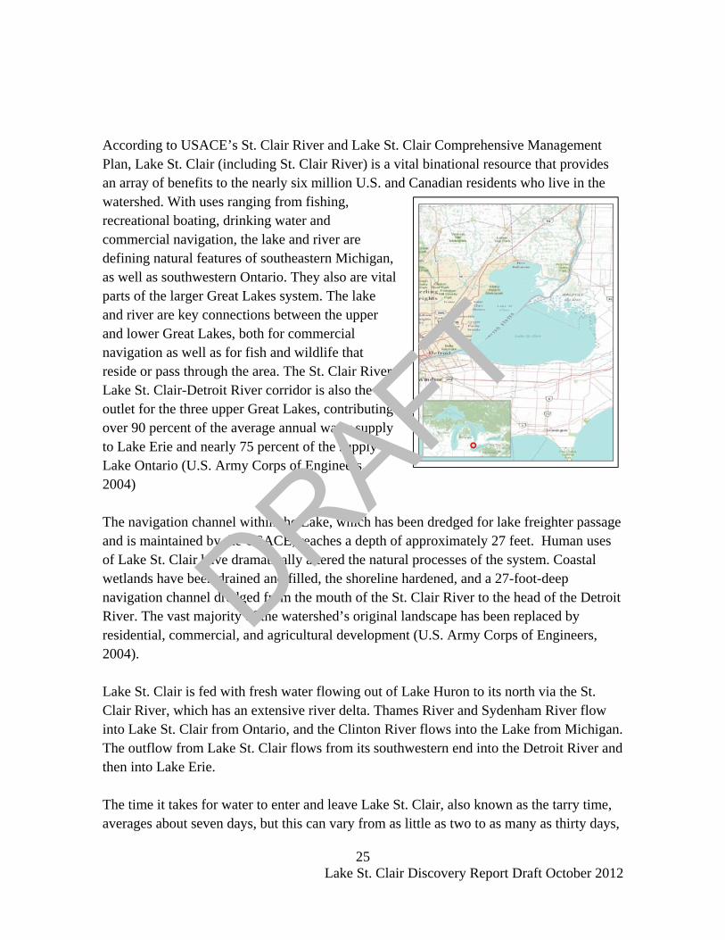
According to USACE’s St. Clair River and Lake St. Clair Comprehensive Management Plan, Lake St. Clair (including St. Clair River) is a vital binational resource that provides an array of benefits to the nearly six million U.S. and Canadian residents who live in the watershed. With uses ranging from fishing, recreational boating, drinking water and commercial navigation, the lake and river are defining natural features of southeastern Michigan, as well as southwestern Ontario. They also are vital parts of the larger Great Lakes system. The lake and river are key connections between the upper and lower Great Lakes, both for commercial navigation as well as for fish and wildlife that reside or pass through the area. The St. Clair River- Lake St. Clair-Detroit River corridor is also the outlet for the three upper Great Lakes, contributing over 90 percent of the average annual water supply to Lake Erie and nearly 75 percent of the supply to Lake Ontario (U.S. Army Corps of Engineers, 2004) The navigation channel within the Lake, which has been dredged for lake freighter passage and is maintained by the USACE, reaches a depth of approximately 27 feet. Human uses of Lake St. Clair have dramatically altered the natural processes of the system. Coastal wetlands have been drained and filled, the shoreline hardened, and a 27-foot-deep navigation channel dredged from the mouth of the St. Clair River to the head of the Detroit River. The vast majority of the watershed’s original landscape has been replaced by residential, commercial, and agricultural development (U.S. Army Corps of Engineers, 2004). Lake St. Clair is fed with fresh water flowing out of Lake Huron to its north via the St. Clair River, which has an extensive river delta. Thames River and Sydenham River flow into Lake St. Clair from Ontario, and the Clinton River flows into the Lake from Michigan. The outflow from Lake St. Clair flows from its southwestern end into the Detroit River and then into Lake Erie. The time it takes for water to enter and leave Lake St. Clair, also known as the tarry time, averages about seven days, but this can vary from as little as two to as many as thirty days,
DRAFT

26 Lake St. Clair Discovery Report Draft October 2012
depending on the direction of the winds, the water circulation patterns, and the seasonal amount of water that is flowing out of Lake Huron. The time the water remains in the Lake is about two days if it flows through the navigation channel. Microtopography has been formed by the dumping of excess material as a result of the dredging of the channel that extends across the lake. The Delta of the St. Clair River is the dominant feature of the Lake. This platform of deltaic deposits has been built out into the Lake, the outer edge of which is bounded by foreset slopes extending downward from platform depths of less than one meter to greater than 3 meters depth (U.S. Army Corps of Engineers, 2004). The subsections below detail trends and issues specific to Lake St. Clair, including water levels, historical flooding and high water marks, coastal flood protection measures, and coastal recession.
i. Water Levels Coastal flooding along the Great Lakes is primarily the result of storm-induced surge and waves and is directly related to the long-term lake water levels. Variations in lake water levels due to decadal scale variations in precipitation and human activities affect the risk of flooding and will be taken into account during the upcoming Great Lakes Coastal Flood Study. NOAA’s Center for Operational Oceanographic Products and Services (CO-OPS) maintains several water level stations along Lake St. Clair. CO-OPS’ primary motivation is the collection and dissemination of high quality and accurate measurements of lake level for scientific studies.
Great Lakes water levels constitute one of the longest high quality hydrometeorological data sets in North America with reference gage records beginning about 1860 with sporadic records back to the early 1800's.
The below table lists the water level stations along Lake St. Clair.
DRAFT

27 Lake St. Clair Discovery Report Draft October 2012
Table 4: Lake St. Clair Water Level Stations
Station Number Station Latitude Longitude
Hourly Records
6-minute Records
9014070 Algonac, MI 42° 37.2' N 82° 31.6' W 1/1975 – 1/2010 1/1996 – 2010 9034052 St. Clair Shores, MI 42° 28.3' N 82° 52.3' W 1/1975 – 1/2010 1/1996 – 2010 9044036 Fort Wayne, MI 42° 17.9' N 83° 50.5' W 1/1975 – 1/2010 1/1996 – 2010 9044049 Windmill Point, MI 42° 21.4' N 82° 55.8' W 1/1975 – 1/2010 1/1999 – 2010
The station information and water level data are available at NOAA CO-OPS Website: http://tidesandcurrents.noaa.gov/station_retrieve.shtml?type=Great Lakes Water Level Data&state=St.+Clair+River&id1=841. According to USACE’s St. Clair River and Lake St. Clair Comprehensive Management Plan, water levels fluctuate significantly in Lake St. Clair due to climate variability upstream on the Lake Superior-Michigan-Huron basins and downstream on the Lake Erie watershed and short-term weather events across the region. Long-term changes in water levels on Lake St. Clair are usually the result of precipitation that is above or below average. Temperature and cloud cover are also factors (U.S. Army Corps of Engineers, 2004). During the early 1960s, low water levels in the Great Lakes were due to several years of below-normal precipitation. In the late 1960s through early 1970s and again in the mid-1980s, heavy precipitation raised water levels to new record highs (U.S. Army Corps of Engineers, 2004). Short-term changes in water levels on Lake St. Clair usually occur within a few days when heavy rains fall on the Thames River watershed in Ontario and the Clinton River watershed in Michigan. This also occurs when ice build-up occurs in the St. Clair and/or Detroit rivers (U.S. Army Corps of Engineers, 2004) Lake levels on Lake St. Clair are also influenced by control of the Lake Superior outflows into St. Marys River at Sault Ste. Marie, Michigan and Ontario. The controls are managed by the International Joint Commission (IJC), in accordance with established criteria to minimize the extremes of levels that can occur on either Lake Superior or the combined Lake Michigan-Huron. This control does affect the magnitude and timing of flows into Lake St. Clair, though is secondary to the local climate causes (U.S. Army Corps of Engineers, 2004).
DRAFT
28 Lake St. Clair Discovery Report Draft October 2012
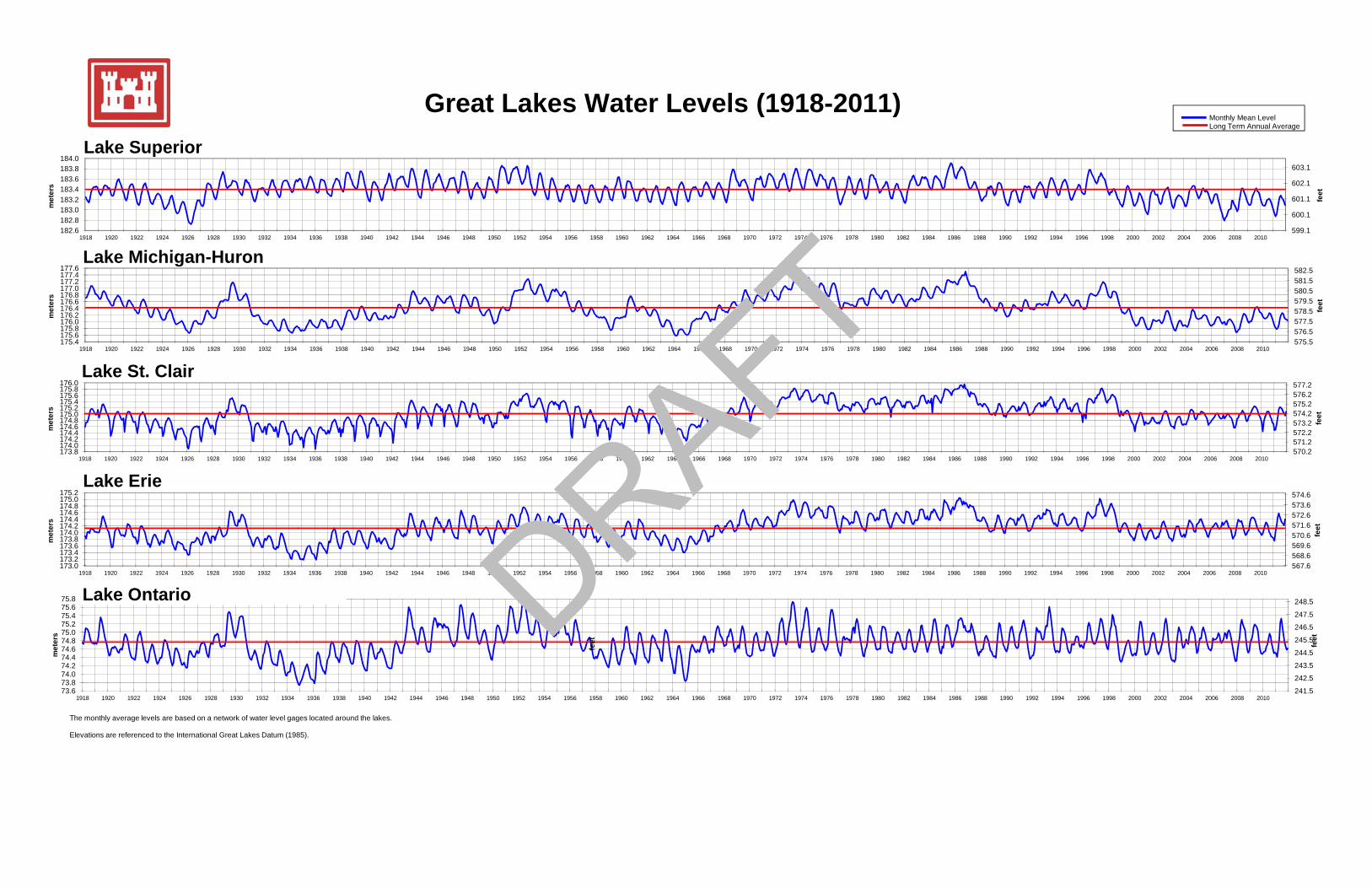
Geologic studies indicate that the upper Great Lakes have regular intervals of high and low levels. Short-term fluctuations usually occur every 30-35 years with long-term fluctuations occurring about every 150-160 years. Water levels have generally declined over the last several years. On average, the Lake’s water level varies about 1.6 ft (0.5 m) depending on the season, with low levels typically occurring in February and high levels occurring in July of each year (U.S. Army Corps of Engineers, 2004) . The longest recorded time series for Lake St. Clair is at Windmill Point gage, and suggests a stationary lake level for the last 100 years. . The monthly high and low water level data from the year 1918 to 2011 at Lake St. Clair are available at the USACE website: http://www.lre.usace.army.mil/greatlakes/hh/greatlakeswaterlevels/
Figure 6, shown on the next page, is USACE’s graphic that shows Historic Great Lakes Water Levels from 1918 to 2011 (U.S. Army Corps of Engineers, 2012). Monthly mean level and long term annual water level elevations are shown in both feet and meters and are referenced to the International Great Lakes Datum (1985).
DRAFT
599.1
600.1
601.1
602.1
603.1
182.6182.8183.0183.2183.4183.6183.8184.0
1918 1920 1922 1924 1926 1928 1930 1932 1934 1936 1938 1940 1942 1944 1946 1948 1950 1952 1954 1956 1958 1960 1962 1964 1966 1968 1970 1972 1974 1976 1978 1980 1982 1984 1986 1988 1990 1992 1994 1996 1998 2000 2002 2004 2006 2008 2010
feet
met
ers
582.5177 4177.6
Lake Michigan-Huron
Lake Superior
Great Lakes Water Levels (1918-2011)Monthly Mean LevelLong Term Annual Average
575.5576.5577.5578.5579.5580.5581.5582.5
175.4175.6175.8176.0176.2176.4176.6176.8177.0177.2177.4177.6
1918 1920 1922 1924 1926 1928 1930 1932 1934 1936 1938 1940 1942 1944 1946 1948 1950 1952 1954 1956 1958 1960 1962 1964 1966 1968 1970 1972 1974 1976 1978 1980 1982 1984 1986 1988 1990 1992 1994 1996 1998 2000 2002 2004 2006 2008 2010
feet
met
ers
570.2571.2572.2573.2574.2575.2576.2577.2
173.8174.0174.2174.4174.6174.8175.0175.2175.4175.6175.8176.0
1918 1920 1922 1924 1926 1928 1930 1932 1934 1936 1938 1940 1942 1944 1946 1948 1950 1952 1954 1956 1958 1960 1962 1964 1966 1968 1970 1972 1974 1976 1978 1980 1982 1984 1986 1988 1990 1992 1994 1996 1998 2000 2002 2004 2006 2008 2010
feet
met
ers
Lake Michigan-Huron
Lake St. Clair
Lake Erie
241 5
242.5
243.5
244.5
245.5
246.5
247.5
248.5
73 673.874.074.274.474.674.875.075.275.475.675.8
feet
met
ers
feet
567.6568.6569.6570.6571.6572.6573.6574.6
173.0173.2173.4173.6173.8174.0174.2174.4174.6174.8175.0175.2
1918 1920 1922 1924 1926 1928 1930 1932 1934 1936 1938 1940 1942 1944 1946 1948 1950 1952 1954 1956 1958 1960 1962 1964 1966 1968 1970 1972 1974 1976 1978 1980 1982 1984 1986 1988 1990 1992 1994 1996 1998 2000 2002 2004 2006 2008 2010
feet
met
ers
Lake Erie
Lake Ontario
241.5
242.5
73.673.874.0
1918 1920 1922 1924 1926 1928 1930 1932 1934 1936 1938 1940 1942 1944 1946 1948 1950 1952 1954 1956 1958 1960 1962 1964 1966 1968 1970 1972 1974 1976 1978 1980 1982 1984 1986 1988 1990 1992 1994 1996 1998 2000 2002 2004 2006 2008 2010
The monthly average levels are based on a network of water level gages located around the lakes.
Elevations are referenced to the International Great Lakes Datum (1985).
DRAFT

30 Lake St. Clair Discovery Report Draft October 2012
Recent developments in mathematical and computer modeling of storm winds, waves, and storm surge, combined with more extensive measurements, provide an opportunity to significantly improve the accuracy of flood risk maps along the Great Lakes (U.S. Army Corps of Engineers, April 2012). In USACE’s draft April 2012 technical report, “Wave Height and Water Level Variability on Lake Michigan and Lake St. Clair”, the evaluation and assessment of lake levels were used as the basis for a proposed strategy for revising the flood risk maps for the Great Lakes. By evaluating long term lake levels, seasonal trends, and storm-induced changes in lake levels on Lake St. Clair, the statistical characteristics of the data was able to be analyzed in the context of computing flood risk. To view USACE’s analysis of the historical storm climatology and resulting measured waves and water levels, detailed history of water levels and wave time series, and flood map methodology proposed to seek improved accuracy to base flood elevation prediction along the Great Lakes, the April 2012 draft technical report “Wave Height and Water Variability on Lakes Michigan and St. Clair” can be accessed from http://www.greatlakescoast.org/ under Technical Resources.
ii. Historical Flooding & High Water Marks The information below was compiled from effective Flood Insurance Studies (FISs) for Macomb, Wayne, and St. Clair Counties (Federal Emergency Managment Agency, 2006) (Federal Emergency Managment Agency, 2010) (Federal Emergency Management Agency, 2012), as well as the future FIS for Macomb County, scheduled to go effective December 4, 2012 (Federal Emergency Managment Agency, December 2012). Local stakeholders who may have historical flooding pictures and high water mark information are encouraged to submit them to FEMA Region V, Mitigation Division. High water marks are defined for this section as marks indicating the highest level of water reached during a flood. Macomb County For Lake St. Clair in Macomb County, the combination of high lake levels and easterly winds produces conditions favorable for flooding. The general desire to live along the shoreline has concentrated development and consequently increased potential flooding damage. The area fronting the lake and immediate canal areas are particularly susceptible to erosion and damage from wave action. Another factor in lower areas
DRAFT
31 Lake St. Clair Discovery Report Draft October 2012
being favorable for flooding is sewer backup associated with high wind tides. Records for the past century show that the rise and fall of the average water surface levels of Lake St. Clair have a cyclic variation between 1.8 feet below to 4.6 feet above the low water datum set in 1933 (Federal Emergency Managment Agency, 2006). Lake flooding is not generally the result of a single storm event, but rather it is the result of a series of causative factors. One such factor occurs when the wind, blowing over large water surface areas, transfers large amounts of energy to the water surface by shear stress. As a result of these stresses acting over a period of time, the water surface is tilted. This tilt will last until the wind velocity is significantly reduced or the wind changes direction. This phenomenon is called wind tides and the magnitude of the tilt between two locations is known as the wind set up. The magnitude of the wind tide depends primarily on the wind speed, the fetch length over which the wind acts, and the depth of the Lake. Lake St. Clair, because of its shallowness and surface area, can react quickly to strong wind forces. Storm waves are another factor that affects the western shore of the Lake. These wind generated waves can reach a height of 4 feet and cause floodwaters to rise higher than recorded flood levels indicate (Federal Emergency Managment Agency, 2006). Historically, the most damaging flooding has occurred along the Lake St. Clair coast in 1973 and again in 1985 and 1986 (U.S. Army Corps of Engineers, 1989). Storms on March 31, 1985, and April 4 and 6, 1985, with high easterly and northeasterly winds, drove the already high waters of Lake St. Clair on shore, inundating portions of all the coastal communities around the Lake. Some of the worst damage was caused by water flowing through gaps in dikes built by the USACE under Operation Foresight in 1973-1974, which were subsequently lowered or removed in the late 1970's by some residents to facilitate access to Lake St. Clair. The three 1985 storms collectively caused about $4.7 million in damages in Macomb County, with 985 homes and 31 businesses reporting flood damages. Instantaneous high still water levels recorded at the St. Clair Shores gage for the 1973, 1985, and 1986 periods are shown in the table below. Still water levels reflect lake setup, but not wave run-up during a storm (Federal Emergency Managment Agency, 2006).
DRAFT

32 Lake St. Clair Discovery Report Draft October 2012
Table 4: High Water Marks
Flooding Source Date Elevation (ft NAVD88)
St. Clair Shores, Macomb County Shoreline - Still water levels March, 1973 577.7
St. Clair Shores, Macomb County Shoreline March, 1985 577.6 St. Clair Shores, Macomb County Shoreline October, 1986 577.9
NAVD88 = North American Vertical Datum of 1988 St. Clair County Flooding in St. Clair County is experienced from rainstorms in the spring or early summer. The more severe flooding occurs in late winter or early spring from rainfall and/or snowmelt in conjunction with ice jams. Water-surface elevations on the Great Lakes vary from season to season and from year to year. Seasonal variations generally reach peak values during the period from May to July, then recede to a low value in the month of February (Federal Emergency Managment Agency, 2010). Continuous winds, blowing strongly from a southerly direction across Lake St. Clair, can create a wind setup or rise in lake level above the normal undisturbed water level along the north shore. Additionally, waves generated by these winds may induce wave run-up or a further increase in water-surface elevations above the setup level. These phenomena are of comparatively short duration and quickly subsides when the wind velocity lessens or the wind direction changes. An increase in the water-surface elevation of Lake St. Clair will be manifested by an attendant rise in the St. Clair River’s stage (Federal Emergency Managment Agency, 2010). Flooding of record in the Township of Clay occurred during the period from March 15 to 19, 1973. Undisturbed water levels in Lake St. Clair were approximately 4.0 feet above low water datum at the time. Southwest winds created an additional wind setup along the northern shore of Lake St. Clair and raised both river and lake stages above overflow levels. Ponding of water was reported in houses, garages and yards in several of the residential areas. This flood had an estimated frequency of 200 years (Federal Emergency Managment Agency, 2010). Low lying areas along in the Township of Clay and the Township of Ira have been subject to periodic flooding caused by overflows of the St. Clair River or rises in the
DRAFT
33 Lake St. Clair Discovery Report Draft October 2012
water levels of Lake St. Clair and the dredged waterways that are directly connected to Lake St. Clair (Federal Emergency Managment Agency, 2010). Wayne County For the portion of Wayne County that borders the Detroit River, Lake Erie, and Lake St. Clair, a combination of high lake and river levels along with easterly winds produces conditions favorable for flooding. Historically, the most damaging floods have occurred as a result of this combination. Severe flooding occurred along this shoreline in 1954, 1973, 1985, and 1986 (U.S. Army Corps of Engineers, 1989; U.S. Army Corps of Engineers, 1974). Storms on March 31, 1985, and April 4 and 6, 1985, along with high easterly and northeasterly winds, drove the already high waters of Lake Erie and Lake St. Clair on shore, inundating several communities along the shoreline. This included portions of the Charter Township of Brownstown; the Cities of Ecorse, Gibraltar, Grosse Pointe, and Grosse Pointe Park; the Township of Grosse Ile; and the extreme northeastern portion of the City of Detroit (Federal Emergency Management Agency, 2012). Some of the worst recorded flooding damage occurred in 1985 when water flowed through gaps in dikes that had been built by the USACE under Operation Foresight in 1973 and 1974. In many locations, these dikes had been lowered or removed by individual residents in the late 1970s to facilitate access to Lake Erie. The storms on March 31, 1985, and April 4 and 6, 1985, collectively caused about $2 million in damages in Wayne County, with approximately 1,300 homes reporting flood damages (U.S. Army Corps of Engineers, 1989)
iii. Coastal Flood Protection Measures Much of the shoreline along Lake St. Clair has steel, concrete, and wood seawalls and breakwaters to protect from flooding and erosion. However, most of these protective works have been inadequate and easily topped by flood waters. Coastal structures and shoreline material along Lake St. Clair will be reviewed in more detail during the engineering analysis of the Lake Clair Study. A summary of information collected regarding existing coastal structures, shoreline material, and flood protection measures is described below.
DRAFT
34 Lake St. Clair Discovery Report Draft October 2012
It’s important to note that these shore protection measures are multi-purpose in nature and do not necessarily offer protection from the 1-percent annual chance of occurrence flood elevations; however, they may protect from most ice damage and from floods of lesser magnitude. During 1972 and 1973, the USACE took emergency measures with Operation Foresight. This program was a cooperative effort between Federal, State, and local governments. With the help of the USACE, most of the shore and canal properties were protected by dikes of sandbags and cribbing under cooperation of residents and volunteers. At that time, at a lakefront elevation of 582.1 feet (NAVD88) in Macomb County, the crib top was approximately 4.6 feet above the highest recorded instantaneous static elevation level and appeared to be adequate protection from wave damage. In St. Clair County, under Operation Foresight, elevations of 580.8 feet (NAVD88) were established for lakefront dikes and 578.5 feet (NAVD88) for canal dikes. In Wayne County, these protection measures consisted of earthen dikes and sand or rock filled cribs in Charter Township of Brownstown and the Cities of Detroit, Ecorse, Gibraltar, Grosse Ile, Grosse Point, and Grosse Point Park (U.S. Army Corps of Engineers, 1974) It’s important to note that the design for Operation Foresight was for a temporary measure, and the dikes and other structures have since been partially removed by home owners. The protection measures were constructed to meet immediate flood threats and were never considered to be permanent. Earth-filled dikes may provide protection from wave action and spray, however, when they are breached or overtopped, they tend to entrap water behind the wall and do not permit drainage back into the Lake (U.S. Army Corps of Engineers, 1974) In 1985, as part of the USACE Advance Measures initiative, additional clay dikes and sand filled cribs where constructed in the Charter Township of Brownstown (Wayne County). In response to flooding in 1985 and 1986, the City of Detroit (Wayne County) made substantial modifications to sheet piling in the vicinity of Fox Creek in the late 1980s. Numerous residential, commercial, and industrial areas along the shore have employed flood protection measures such as the filling of lower areas or the installation of sheet piling for bank stabilization and shore protection (U.S. Army Corps of Engineers, 1974). Many local property owners use seawalls, revetments, riprap, and/or groins to prevent storm damage and beach erosion along Lake St. Clair. Concrete and steel sheet piling
DRAFT
35 Lake St. Clair Discovery Report Draft October 2012
at the bank level protect against erosion. (Federal Emergency Managment Agency, 2010). A levee exists in Wayne County along the Grosse Pointe Park Lake St. Clair shoreline. The February 2, 2012 effective FIRMs for Wayne County depict this levee as providing protection from the 1-percent-annual-chance flood event per a Provisionally Accredited Levee (PAL) agreement. As of the date of this report, the PAL agreement has expired and thus the area designated as PAL behind the levee system, and mapped as a Zone X (shaded), is currently under review regarding the extent to which the levee provides protection from the 1-percent-annual-chance flood. Additional information on PALs can be found by visiting http://www.fema.gov/library/viewRecord.do?id=1987 . The regulatory requirements of the NFIP that apply to the evaluation and mapping of levee systems and levee-impacted areas are cited at Title 44, Chapter 1, Section 65.10 of the Code of Federal Regulations. Interested parties may access Section 65.10 of the NFIP regulations through the FEMA website at http://www.fema.gov/library/viewRecord.do?id=2741 . The USACE also maintains a large infrastructure of over 900 coastal structures in the United States. These coastal structures protect harbors and shore-based infrastructure, provide beach and shoreline stability control, provide flood protection to varying degrees, and protect coastal communities, roadways and bridges, etc. These maintained coastal structures include seawalls, bulkheads, revetments, dikes and levees, breakwaters, groins, sills/perched beaches, and jetties and piers. The USACE coastal structure data for Lake St. Clair was extracted from the Enterprise Coastal Inventory Database from the Engineer Research and Development Center through the USACE. As previously stated, it is important to note that these coastal structures do not necessarily protect areas from the 1-percent-annual-chance flood event. Many of these USACE coastal structures were built between 1860 and 1940 and low Lake water levels since the 1990’s have accelerated deterioration. The table below lists the coastal structures found within the Lake St. Clair basin that are maintained by the USACE.
DRAFT

36 Lake St. Clair Discovery Report Draft October 2012
Table 5: USACE Coastal Inventory Database
USACE Office
Coastal Structure Name State
Completion Date Type
Length (m)
Length (ft)
Detroit Clinton River Breakwater MI 1966
Laid Stone 4263.7 1400
Detroit Clinton River Earth-Fill MI 1966
Rock Rubble 1127.8 3700
The USACE has recently performed condition assessments to obtain average overall condition of each structure. The Clinton River structures have been given a “B” rating, which indicates low risk of failure. Please note that identified structures will be assessed in greater detail during the engineering portion of this coastal flood study and have not been assessed as part of this report. The figure on the next page shows the 2012 USACE shoreline feature dataset, including identification of artificial shoreline material (which may include steel, concrete, or wood seawalls as described above), as well as the USACE Coastal Inventory within the Lake St. Clair basin.
DRAFT

37 Lake St. Clair Discovery Report Draft October 2012
Figure 7: Lake St. Clair Shoreline Material and Coastal Structures
DRAFT

38 Lake St. Clair Discovery Report Draft October 2012
iv. Coastal Recession In Michigan, areas prone to erosion along the shoreline, including Lake St. Clair, are subject to special setback requirements established by the Michigan Department of Environmental Quality (MDEQ). From the MDEQ’s website (http://www.michigan.gov/deq/ ), high risk erosion areas are those shorelands of the Great Lakes and connecting waters where recession of the zone of active erosion has been occurring at a long-term average rate of one foot or more per year. The erosion can be caused from one or several factors, including high water levels, storms, wind, ground water seepage, surface water runoff, and frost. The high risk erosion area regulations require setback distances to protect new structures from erosion for a period of 30 to 60 years, depending on the size, number of living units and type of construction. Approximately 300 miles of shoreline are classified as high risk erosion area. Updates of the recession rate studies, which form the basis of the setbacks, are periodically conducted to reflect changing water levels and shore protection efforts. For the Lake St. Clair study area, high risk erosion area maps were provided by MDEQ for the Township of Fort Gratiot (part of Lake Huron study) and the City of Port Huron (St. Clair County) and can be found in Appendix G of this report. The maps depict the high risk erosion areas and show the number, in feet, of the 30-year projected recession distance and 50-year projected recession distance. Additional information can be found at the MDEQs High Risk Erosion Areas website at http://www.michigan.gov/deq/0,1607,7-135-3313_3677_3700-10860--,00.html .
DRAFT

39 Lake St. Clair Discovery Report Draft October 2012
VII. Hazard Mitigation Resources, Strategies, and Actions A review of hazard mitigation resources, strategies, and actions was performed as part of this Discovery process and were discussed with Lake St. Clair stakeholders during the Information Exchange Sessions and the Discovery Meetings. This section provides general information about hazard mitigation, as well as mitigation topics specific to Lake St. Clair.
i. Hazard Mitigation Overview Hazard mitigation is any sustained action taken to reduce or eliminate the long-term risk to human life and property from hazards. This creates safer communities and facilitates resilience by enabling communities to return to normal function as quickly as possible after a hazard event. Once local officials understand risk from flooding and other hazards, the community is in a better position to identify potential mitigation actions that can reduce that risk to its people and property. Mitigation activities may be implemented prior to, during, or after an incident. However, it has been demonstrated that hazard mitigation is most effective when based on an inclusive, comprehensive, long-term plan that is developed before a disaster occurs. Hazard mitigation planning helps communities develop strategies to reduce their risk to natural hazard events. Mitigation Plans form the foundation for a community's long-term strategy to reduce disaster losses and break the cycle of disaster damage, reconstruction, and repeated damage. The planning process is as important as the plan itself. It creates a framework for risk-based decision making to reduce damages to lives, property, and the economy from future disasters. As part of this Discovery process, existing Hazard Mitigation Plans in the study area were reviewed to better understand flood risks within the Lake St. Clair communities, and the strategies and actions that have already been developed as part of their planning process. By obtaining a better understanding of efforts made at the local level to reduce risk, FEMA can identify areas of need or areas where partnerships may be formed throughout this Great Lakes Coastal Flood Study process. The status of Hazard Mitigation Plans in Macomb, St. Clair, and Wayne Counties is listed in the table below:
DRAFT

40 Lake St. Clair Discovery Report Draft October 2012
Table 6: Hazard Mitigation Plan Status
JURISDICTION APPROVAL
DATE EXPIRATION
DATE
Macomb County (Multi-Jurisdictional) November 9, 2010 November 9, 2015
St. Clair County (Multi-Jurisdictional) May 9, 2006 May 9, 2011 Wayne County (City of Detroit) March 22, 2007 March 22, 2012 Wayne County (Multi-Jurisdictional) June 22, 2007 June 22, 2012
Source: FEMA Region V
Hazard mitigation plans are required by the Robert T. Stafford Disaster Relief and Emergency Assistance Act (Public Law 93-288), as amended by the Disaster Mitigation Act of 2000, as well as the National Flood Insurance Act of 1968, as amended by the Flood Insurance Reform Act of 2004 (Public Law 108-264). Under the Disaster Mitigation Act of 2000; governments have certain responsibilities including reviewing and updating effective mitigation plans every five (5) years. From the previous table, St. Clair County, Wayne County, and the City of Detroit all have expired hazard mitigation plans. Currently, both St. Clair County and the City of Detroit have obtained planning grants and efforts are underway to update their respective Hazard Mitigation Plans. Figures 8 displays the status of local hazard mitigation plans, along with hazard mitigation projects that have been funded historically. In Lake St. Clair, several projects that involved the elevation of structures, labeled “Elevation Increase” in the figure below, occurred along the Macomb County shoreline
DRAFT

41 Lake St. Clair Discovery Report Draft October 2012
Figure 8: Hazard Mitigation
DRAFT

42 Lake St. Clair Discovery Report Draft October 2012
As a part of the review of the local Hazard Mitigation Plans included in this Discovery process, potential mitigation actions and strategies were compiled from each plan and have been provided as tables within the county-base reports found in Appendices C (Macomb County), D (St. Clair County), and E (Wayne County). The below tables contains a summary of common hazard mitigation actions related to flooding in Lake St. Clair coastal communities. Note that mitigation actions compiled in the table below may apply to all types of flooding, not just coastal.
Table 7: Summary of Potential Mitigation Actions and Strategies
Action Number Hazard Mitigation Action or Strategy
1 Flood proof homes
2 Mitigate flooding of roads
3 Mitigate flooding of residences along shoreline
4
Develop disaster mitigation/emergency response GIS. Continue to enhance the capabilities of GIS systems to function as a planning tool to aid in regulatory efforts to mitigate hazard events.
5 Install flood monitoring equipment
6 Riverbank stabilization and restoration to the parts of the riverbanks to prevent future floodwater erosion of the streambank.
7 Proposed dredging, riverbank stabilization, debris removal, retention basin construction
8 Maintain updated floodplain mapping
9 Implement land use planning regulations in floodplain and coastal zone areas
10
Alleviate repetitive loss properties by: wet floodproofing of structures; dry floodproofing structures; acquisition of repetitive loss properties; purchase or transfer of development rights; conservation easements
11 Implement effective stormwater management.
DRAFT
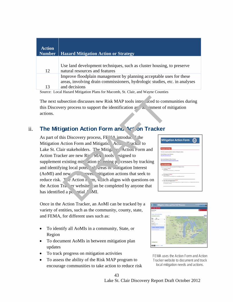
43 Lake St. Clair Discovery Report Draft October 2012
FEMA uses the Action Form and Action Tracker website to document and track
local mitigation needs and actions.
Action Number Hazard Mitigation Action or Strategy
12 Use land development techniques, such as cluster housing, to preserve natural resources and features
13
Improve floodplain management by planning acceptable uses for these areas, involving drain commissioners, hydrologic studies, etc. in analyses and decisions
Source: Local Hazard Mitigation Plans for Macomb, St. Clair, and Wayne Counties
The next subsection discusses new Risk MAP tools introduced to communities during this Discovery process to support the identification and attainment of mitigation actions.
ii. The Mitigation Action Form and Action Tracker As part of this Discovery process, FEMA introduced the Mitigation Action Form and Mitigation Action Tracker to Lake St. Clair stakeholders. The Mitigation Action Form and Action Tracker are new Risk MAP tools designed to supplement existing mitigation planning processes by tracking and identifying local potential Areas of Mitigation Interest (AoMI) and new or improved mitigation actions that seek to reduce risk. The Action Form, which aligns with questions on the Action Tracker website, can be completed by anyone that has identified a potential AoMI. Once in the Action Tracker, an AoMI can be tracked by a variety of entities, such as the community, county, state, and FEMA, for different uses such as: • To identify all AoMIs in a community, State, or
Region • To document AoMIs in between mitigation plan
updates • To track progress on mitigation activities • To assess the ability of the Risk MAP program to
encourage communities to take action to reduce risk
DRAFT

44 Lake St. Clair Discovery Report Draft October 2012
It is important to note that entering a potential Mitigation Action does not obligate a jurisdiction to fund or complete an identified action. When updating local Hazard Mitigation Plans, local planning teams may find it useful to review the actions stored in the Mitigation Action Tracker, assess them, and consider adding them as a new or modified actions during the planning process. Through collaboration between Risk MAP project teams and communities, new actions can be identified and existing actions may be improved upon. In addition, funding and collaboration opportunities to implement mitigation actions may be identified. Stakeholders who attended the Discovery Meetings were provided with the Mitigation Action Form (Appendix H) and were encouraged to complete and return the form to FEMA Region V. Although no forms for the Lake St. Clair project area had been returned to FEMA at the time this report was created, there was discussion throughout the discovery process between the local stakeholders and FEMA regarding the intent to update the expired Hazard Mitigation Plans in St. Clair County and Wayne County in the near future. The updating of Hazard Mitigation Plans is considered to be an identified action. The Mitigation Action Tracker can be accessed at: http://fema.starr-team.com The Mitigation Action Form template can be downloaded and printed at http://fema.starr-team.com/MAF-Form.pdf . FEMA is undertaking an effort in 2012, with support from state partners and a core stakeholder group, to identify a strategy that defines hazard mitigation actions to reduce loss of life and property and build resilience throughout the coastal communities of the Great Lakes regions.
FEMA’s Mitigation Planning Technical Assistance (MPTA) may also be available to help communities plan for and reduce risks by providing communities with specialized assistance. MPTA is a part of the Risk MAP program and includes risk assessment, mitigation planning, and traditional hazard identification (flood mapping) activities. Additional information on MPTA and how it applies to the Lake St. Clair Coastal Flood Study is included in Section VIII of this report under “Potential for Mitigation Assistance”. The next subsection provides examples of mitigation actions.
DRAFT

45 Lake St. Clair Discovery Report Draft October 2012
I.VII.ii.1 Types of Mitigation Actions Hazard mitigation actions include adoption of local plans and regulations, creation of community identified programs that may help to reduce flood risk or other risks within a community, and structure and infrastructure projects. The FEMA Mitigation Action Form requests the identification of potential mitigation actions in one of these 3 categories. The outline presented below lists the types of possible flood-related actions within each category: Local Plans and Regulations: • Adopt building codes. The use and enforcement of building codes and
development standards can ensure structures are safe from flooding. • Adopt planning and land use regulations. These regulations can mitigate
flooding by influencing development. Consider updating and aligning Comprehensive and Master Plans, as well as other local plans to ensure that risk is considered at all levels of community planning.
• Adopt stormwater management plan. Rainwater and snowmelt can cause flooding and erosion in developed areas and the plan can seek to mitigate that risk.
• Adopt floodplain management. Through enforcement and adoption of NFIP floodplain management requirements, communities can reduce risk for new developed areas, and property owners in participating communities may purchase insurance protection against flood losses.
Community Identified Programs: • Create funding mechanisms for local risk reduction. • Create incentives for local risk reduction. • Create a mitigation program at the local level that seeks to reduce risk from
flooding and other natural hazards. Structure and Infrastructure Projects: • Protect structures from flood damage by elevating the structure, raising or
floodproofing HVAC equipment, installing sewer backflow valves, dry floodproofing a building, or constructing with flood-resistant materials.
DRAFT
46 Lake St. Clair Discovery Report Draft October 2012
Communities can link hazard mitigation
plans and actions to the right FEMA grant programs to fund flood risk reduction. More information about FEMA HMA
programs can be found at http://www.fema.gov/hazard-mitigation-
assistance
• Flood control structures, such as levees and dikes, can also be built to prevent flood damage to infrastructure, critical facilities, and residential or non-residential structures.
• Soil stabilization or erosion control projects can be completed to stabilize slopes that may be susceptible to erosion
To learn more about mitigation planning, mitigation actions, and mitigation best practices, we recommend you visit http://www.fema.gov/hazard-mitigation-planning-resources . The next section discusses funding opportunities that may be available to assist local officials in implementing hazard mitigation planning and projects.
iii. Hazard Mitigation Programs and Assistance Not all mitigation activities require funding, and those that do are not limited to outside funding sources. For those mitigation actions that require assistance through funding or technical expertise, several state and federal agencies have flood hazard mitigation grant programs and offer technical assistance. These programs may be funded at different levels over time or may be activated under special circumstances such as after a presidential disaster declaration. FEMA, as well as other federal agencies, award many mitigation grants each year to states and communities to undertake mitigation projects to prevent future loss of life and property resulting from hazard impacts, including flooding. The FEMA Hazard Mitigation Assistance (HMA) programs provide grants for mitigation through the programs listed below. State and local mitigation plans are a requirement for most FEMA HMA project grant funding.
DRAFT

47 Lake St. Clair Discovery Report Draft October 2012
Table 8: FEMA Hazard Mitigation Assistance (HMA) Program
Mitigation Grant
Program Authorization Purpose
Hazard Mitigation
Grant Program (HMGP)
Robert T. Stafford
Disaster Relief and Emergency Assistance Act
Activated after a presidential disaster declaration; provides funds on a sliding scale formula based on a percentage of the total federal assistance for a disaster for long-term mitigation measures to reduce vulnerability to natural hazards
Flood Mitigation Assistance
(FMA)
National Flood Insurance
Reform Act
Reduce or eliminate claims against the NFIP
Pre-Disaster Mitigation
(PDM)
Disaster Mitigation Act
National competitive program focused on mitigation project and planning activities that address multiple natural hazards (program under review)
Repetitive Flood Claims
(RFC)
Bunning-Bereuter-
Blumenauer Flood Insurance
Reform Act
Reduce flood claims against the NFIP through flood mitigation; properties must be currently NFIP insured and have had at least one NFIP claim
Severe Repetitive
Loss (SRL)
Bunning-Bereuter-
Blumenauer Flood Insurance
Reform Act
Reduce or eliminate the long-term risk of flood damage to SRL residential structures currently insured under the NFIP
The HMGP and PDM programs offer funding for mitigation planning and project activities that address multiple natural hazard events. The FMA, RFC, and SRL programs focus funding efforts on reducing claims against the NFIP. Funding under the HMA programs is subject to availability of annual appropriations, and HMGP funding is also subject to the amount of FEMA disaster recovery assistance provided under a presidential major disaster declaration. FEMA’s HMA grants are awarded to eligible states, tribes, and territories (applicant) that, in turn, provide subgrants to local governments and communities (subapplicant). The applicant selects and prioritizes subapplications developed and submitted to them by subapplicants and submits them to FEMA for funding consideration. Prospective subapplicants should consult the office designated as their applicant for further
DRAFT
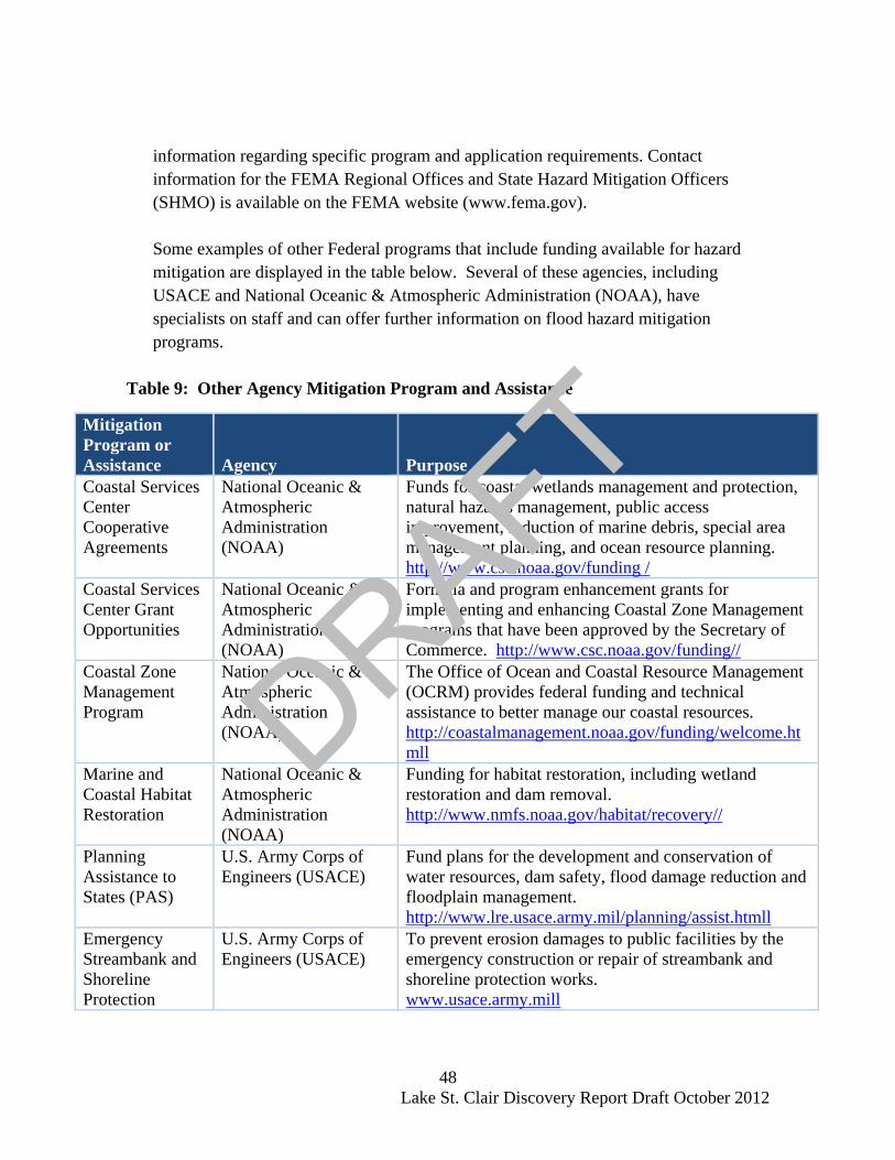
48 Lake St. Clair Discovery Report Draft October 2012
information regarding specific program and application requirements. Contact information for the FEMA Regional Offices and State Hazard Mitigation Officers (SHMO) is available on the FEMA website (www.fema.gov). Some examples of other Federal programs that include funding available for hazard mitigation are displayed in the table below. Several of these agencies, including USACE and National Oceanic & Atmospheric Administration (NOAA), have specialists on staff and can offer further information on flood hazard mitigation programs.
Table 9: Other Agency Mitigation Program and Assistance
Mitigation Program or Assistance Agency Purpose Coastal Services Center Cooperative Agreements
National Oceanic & Atmospheric Administration (NOAA)
Funds for coastal wetlands management and protection, natural hazards management, public access improvement, reduction of marine debris, special area management planning, and ocean resource planning. http://www.csc.noaa.gov/funding /
Coastal Services Center Grant Opportunities
National Oceanic & Atmospheric Administration (NOAA)
Formula and program enhancement grants for implementing and enhancing Coastal Zone Management programs that have been approved by the Secretary of Commerce. http://www.csc.noaa.gov/funding//
Coastal Zone Management Program
National Oceanic & Atmospheric Administration (NOAA)
The Office of Ocean and Coastal Resource Management (OCRM) provides federal funding and technical assistance to better manage our coastal resources. http://coastalmanagement.noaa.gov/funding/welcome.htmll
Marine and Coastal Habitat Restoration
National Oceanic & Atmospheric Administration (NOAA)
Funding for habitat restoration, including wetland restoration and dam removal. http://www.nmfs.noaa.gov/habitat/recovery//
Planning Assistance to States (PAS)
U.S. Army Corps of Engineers (USACE)
Fund plans for the development and conservation of water resources, dam safety, flood damage reduction and floodplain management. http://www.lre.usace.army.mil/planning/assist.htmll
Emergency Streambank and Shoreline Protection
U.S. Army Corps of Engineers (USACE)
To prevent erosion damages to public facilities by the emergency construction or repair of streambank and shoreline protection works. www.usace.army.mill
DRAFT

49 Lake St. Clair Discovery Report Draft October 2012
Mitigation Program or Assistance Agency Purpose Environmental Laboratory
U.S. Army Corps of Engineers (USACE)
Guidance for implementing environmental programs such as ecosystem restoration and reuse of dredged materials. http://el.erdc.usace.army.mil/index.cfmm
Small Flood Control Projects
U.S. Army Corps of Engineers (USACE)
To reduce flood damages through small flood control projects not specifically authorized by congress. www.usace.army.mill
Coastal Wetlands Conservation Grant Program
U.S. Fish & Wildlife Service
Matching grants to states for acquisition, restoration, management or enhancement of coastal wetlands. http://ecos.fws.gov/coastal_grants/viewContent.do?viewPage=homee
Disaster Recovery Assistance
U.S. Department of Housing and Urban Development (HUD)
Disaster relief and recovery assistance in the form of special mortgage financing for rehabilitation of impacted homes. http://portal.hud.gov/hudportal/HUD?src=/program_offices/comm_planning/communitydevelopment/programs/dri
Neighborhood Stabilization Program
U.S. Department of Housing and Urban Development (HUD)
Funding for the purchase and rehabilitation of foreclosed and vacant property in order to renew neighborhoods devastated by the economic crisis. http://portal.hud.gov/hudportal/HUD?src=/program_offices/comm_planning/communitydevelopment/programs/neighborhoodspg
USDA Smith-Lever Special Needs Funding
U.S. Department of Agriculture (USDA)
Grants to State Extension Services at 1862 Land-Grant Institutions to support education-based approaches to addressing emergency preparedness and disasters. http://www.csrees.usda.gov/funding/rfas/smith_lever.html
Community Facilities Direct Loans
U.S. Department of Agriculture (USDA)
Loans for essential community facilities. http://www.rurdev.usda.gov/HCF_CF.html
Community Facilities Direct Grants
U.S. Department of Agriculture (USDA)
Grants to develop essential community facilities. http://www.rurdev.usda.gov/HCF_CF.html
Farm Service Agency Disaster Assistance Programs
U.S. Department of Agriculture (USDA)
Emergency funding and technical assistance for farmers and ranchers to rehabilitate farmland and livestock damaged by natural disasters. http://www.fsa.usda.gov//
DRAFT
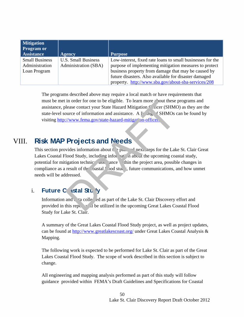
50 Lake St. Clair Discovery Report Draft October 2012
Mitigation Program or Assistance Agency Purpose Small Business Administration Loan Program
U.S. Small Business Administration (SBA)
Low-interest, fixed rate loans to small businesses for the purpose of implementing mitigation measures to protect business property from damage that may be caused by future disasters. Also available for disaster damaged property. http://www.sba.gov/about-sba-services/208
The programs described above may require a local match or have requirements that must be met in order for one to be eligible. To learn more about these programs and assistance, please contact your State Hazard Mitigation Officer (SHMO) as they are the state-level source of information and assistance. A listing of SHMOs can be found by visiting http://www.fema.gov/state-hazard-mitigation-officers .
VIII. Risk MAP Projects and Needs This section provides information about the planned next steps for the Lake St. Clair Great Lakes Coastal Flood Study, including information about the upcoming coastal study, potential for mitigation technical assistance within the project area, possible changes in compliance as a result of the coastal flood study, future communications, and how unmet needs will be addressed.
i. Future Coastal Study Information and data collected as part of the Lake St. Clair Discovery effort and
provided in this report will be utilized in the upcoming Great Lakes Coastal Flood Study for Lake St. Clair.
A summary of the Great Lakes Coastal Flood Study project, as well as project updates, can be found at http://www.greatlakescoast.org/ under Great Lakes Coastal Analysis & Mapping. The following work is expected to be performed for Lake St. Clair as part of the Great Lakes Coastal Flood Study. The scope of work described in this section is subject to change.
All engineering and mapping analysis performed as part of this study will follow guidance provided within FEMA’s Draft Guidelines and Specifications for Coastal
DRAFT

51 Lake St. Clair Discovery Report Draft October 2012
Studies Along the Great Lakes, issued on May 8, 2012 (Federal Emergency Management Agency, 2012).
I.VIII.i.1 Engineering and Mapping Coastal flood hazard analyses and mapping for all communities of the United States located along the Lake St. Clair shoreline will be performed. Below is a summary of data that will be collected and analysis that will be performed: 1) Creation of Bathymetric and Topographic Map Data Inventory:
New bathymetric LiDAR, RGB Imagery and Hyperspectral Imagery will be used for the coastal study areas. The LiDAR used will have 1 meter cell bare earth DEMs, as well as classified LAS point cloud files.
Topographic data for the coastal areas to be studied will be used for coastal analysis, floodplain boundary delineation and/or testing of floodplain boundary standard compliance. The topographic data used will be based on the data collected as part of this Discovery process, and will depend on the ability to gather currency and accuracy information for existing topographic data. Only topographic data that is of better quality than that of the original study or effective studies will be used.
2) Base Map Acquisition
Basemap data for all counties, including data collected during this Discovery process as an initial inventory, will be collected and/or organized and the necessary permission from the map source will be obtained to allow FEMA use and distribution of hardcopy and digital map products using the digital base map. Base map data must comply with FEMA Guidelines & Specifications (Federal Emergency Managment Agency, 2003).
3) Coastal Flood Hazard Analysis
Response-based computational approaches outlined in Appendix D.3 dated May 2012 will be used to perform coastal flood hazard analysis for the Lake St. Clair shoreline and areas subject to coastal flooding. The coastal flood hazard analyses include the following components:
DRAFT

52 Lake St. Clair Discovery Report Draft October 2012
• Wave setup • Erosion • Wave runup • Wave overtopping • Overland wave propagation • Primary frontal dune identification (where applicable).
A transect-based approach for assessing coastal flood risks along Lake St. Clair will be used. The Lake St. Clair study will include the St. Clair River included within the model domain defined by USACE – Engineering Research and Data Center for Lake St. Clair. The 1.5 foot breaking wave height will be selected from the WHAFIS results and used to define the Limit of Moderate Wave Action (LiMWA) as described in FEMA Procedural Memorandum No. 50.
The coastal flood hazard results will be transferred to topographic work maps. Topographic data provided by the USACE in 2012 will be utilized. Coastal flood hazards will be mapped as outlined in FEMA’s Guidelines and Specifications Appendix D.3 dated May 2012 (Federal Emergency Management Agency, 2012). Flood hazard mapping will extend to the landward limit of coastal flooding as a result of waves and storm surge.
Draft coastal flood maps (or workmaps) will be produced for the study area. The workmap will include the 1-percent- and 0.2-percent-annual chance Special Flood Hazard Area (SFHA), Coastal High Hazard (VE Zone) and Coastal A Zone (AE Zone), Base Flood Elevations (BFEs), and Limit of Moderate Wave Action (LiMWA). Communities will be provided with an opportunity to review the workmaps prior to FIRM production.
I.VIII.i.2 National Flood Insurance Program Data Integration Regulatory Digital Flood Insurance Rate Map (DFIRM) files will be updated through FEMA’s Physical Map Revision (PMR) process using the results from the work performed in the Engineering and Mapping tasks.
DRAFT

53 Lake St. Clair Discovery Report Draft October 2012
The floodplain delineations created in the Engineering and Mapping tasks will be used. For areas adjacent to updated coastal analysis, tie-ins will be resolved between coastal floodplain and riverine using the topographic data acquired.
Data collected as part of the coastal analysis will be put into DFIRM database format and reviewed per FEMA’s Guidelines and Specifications. The final production and distribution of updated FIRMs will be dependent on the results of the coastal analysis and discussions with the communities. Therefore, it cannot yet be identified at this time the exact communities that will received updated FIRMs for adoption. The risk assessment products and their distribution, discussed below, are also dependant on the results of the coastal analysis and further community discussions and are subject to change.
I.VIII.i.3 Risk Assessment Product Development Depending on available data, results of coastal analysis, local needs identified, local partnerships, and fiscal year funding, coastal flood risk products may be generated for identified coastal communities in Macomb, St. Clair, and Wayne Counties, as summarized in Table 10. Table 10: Potential Flood Risk Products for Lake St. Clair
County State
Flood Risk Map and Flood Risk Report
Changes Since Last FIRM
Flood Depth and Analysis Grids
Hazus-MH
Optional Flood Risk Assessment Products
Macomb MI X X X X Not yet funded St. Clair MI X X X X Not yet funded Wayne MI X X X X Not yet funded
DRAFT

54 Lake St. Clair Discovery Report Draft October 2012
Below is a brief description of each flood risk product and their uses: Changes Since Last FIRM (CSLF)
The CSLFs serve the following purposes:
• Identify Areas and Types of Flood Zone Change: Compares current effective (previous) with proposed (new) flood
hazard mapping; and Flood zone changes are categorized and quantified.
• Provide Study/Reach Level Rationale for Changes Including:
Methodology and assumptions; and Changes of model inputs or parameters (also known as
Contributing Engineering Factors). Flood Depth and Analysis Grids
• Flood Depth and Analysis Grids will be created for the 1% frequency event of the engineering studies performed and as appropriate for the data. Wave runup areas may not be applicable. Flood-depth and analysis grids (DAGs) will include the 1-percent-annual chance flood for coastal areas.
HAZUS 2010: 1-Percent Exposure
• The 2010 HAZUS national dataset for 1-percent exposure data will be used to tabulate the results by identified community.
A Flood Risk Map, Flood Risk Report, and Flood Risk Database may also be developed as part of this process, in conjunction with the above described products, and is also dependant on results of coastal analysis, data availability, and fiscal year funding. For additional information regarding Coastal Flood Risk products, Flood Risk Maps, Flood Risk Reports, and Flood Risk Databases, users may review the county-based reports found in Appendices C, D, and E of this report, or visit http://www.fema.gov .
DRAFT
55 Lake St. Clair Discovery Report Draft October 2012
ii. Potential for Mitigation Assistance As part of a Risk MAP project, Mitigation Planning Technical Assistance (MPTA) may available to help communities plan for and reduce risks by providing communities with specialized assistance. MPTA includes risk assessment, mitigation planning, and traditional hazard identification (flood mapping) activities. Technical assistance through MTPA can be performed at any time during the hazard mitigation planning process. Determining which communities receive MPTA is dependent on identification of a need, the willingness of a community to partner with FEMA, local resources and data availability, and federal funding availability. Unfortunately, not every community will be able to receive MPTA as part of a Risk MAP project. Forming a partnership between FEMA and a local community is an essential part of initiating a MPTA project. Assistance will be prioritized after all data and information is collected and assessed by FEMA in coordination with the local communities to determine where MPTA resources would be beneficial. Communities should alert FEMA of any resources that are available at the local level, and of actions they are interested in implementing in partnership with FEMA. Technical assistance activities should be based on the needs of the community and assist with already established capabilities. Some technical assistance activities could include (but are not limited to):
• Advising in the creation of initial Hazard Mitigation Plans • Advising in the update of existing Hazard Mitigation Plans • Training to improve a community’s capabilities for reducing risk • Assistance in incorporating flood risk datasets and products into potential and
effective community legislation, guidance, regulations, procedures, etc. • Assistance with the creation, acquisition and incorporation of GIS data into
potential and effective maps, planning mechanisms, emergency management procedures, etc.
• Facilitating the identification of data gaps and interpret technical data to identify risk reduction definiencies that should be corrected.
During this discovery process, it was identified that St. Clair County and City of Detroit (Wayne County) have received planning grants and are in the process of updating their Hazard Mitigation Plans. Wayne County’s Hazard Mitigation Plan has expired and plans to update were unknown at the time this report was developed. It is recommended additional discussion occur between FEMA and these stakeholders as
DRAFT

56 Lake St. Clair Discovery Report Draft October 2012
this coastal flood study moves forward to see if MPTA would be an appropriate and beneficial option. Continued discussion regarding FEMA partnership with local communities to assist in developing new mitigation actions and moving those actions forward will be essential as well as this coastal project moves forwards.
iii. Compliance FEMA uses a number of key tools to determine a community’s compliance with the minimum regulations of the NFIP. Among them are Community Assistance Visits (CAVs), the Letter of Map Change (LOMC) process, and Submit-for-Rates. These tools help assess a community’s implementation of their flood damage reduction regulations and identify any floodplain management deficiencies and violations. The CAV is a visit to a community by a FEMA staff member or staff of a state agency on behalf of FEMA that serves the dual purpose of providing technical assistance to the community and assuring that the community is adequately enforcing its floodplain management regulations. Potential violations may be identified during the CAV visit as a result of touring the floodplain, inspecting community permit files, and meeting with local appointed and elected officials. Violations can also be discovered when Letter of Map Revision based on Fill (LOMR-F) applications depict a non-compliant structure based on elevation data; or can be found through Submit-for-Rate requests, which occur when a structure applies for flood insurance but has been identified as being two or more feet below Base Flood Elevation (BFE). Elevation comparisons identified through LOMR-F applications and Submit-for-Rates imply structures were not built compliantly. No potential LOMR-F violations or Submit-for-Rate issues were identified at the time this report was created. If administrative problems or potential violations are identified, the community will be notified and given the opportunity to correct those administrative procedures and remedy the violations to the maximum extent possible within established deadlines. FEMA or the state will work with the community to help them bring their program into compliance with NFIP requirements. In extreme cases where the community does not take action to bring itself into compliance FEMA may initiate an enforcement action against the community.
DRAFT

57 Lake St. Clair Discovery Report Draft October 2012
After coastal analysis is completed for this study, communities may be faced with adopting new regulations related to coastal high hazard areas. An understanding of regulations associated with coastal areas will be important so that communities remain compiant. During this Discovery process, stakeholders were provided with information regarding NFIP requirements that are associated with coastal hazard zones, as well as information about new FEMA guidance related to moderate wave action. These topics, including coastal Special Flood Hazard Areas (SFHAs), building requirements in VE Zones, and Limit of Moderate Wave Action (LiMWA), are compiled below and discussed in greater detail.
I.VIII.iii.1 Coastal Special Flood Hazard Areas (SFHAs)
The Lake St. Clair Coastal Flood Hazard study analysis may result new Special Flood Hazard Areas (SFHAs), which is defined as the area that will be inundated by the flood event having a 1-percent chance of being equaled or exceeded in any given year. The 1-percent annual chance flood is also referred to as the base flood or 100-year flood. SFHAs labeled as Zone AE have been studied by detailed methods and show Base Flood Elevations (BFEs). SFHAs labeled as Zone VE are along coasts and are subject to additional hazards due to storm-induced velocity wave action. BFEs derived from detailed hydraulic analyses are shown within these zones. The NFIP shows coastal flood hazards in two different zones on its FIRMs: • Zone VE, where the delineated flood hazard includes wave heights equal
to or greater than three feet; and • Zone AE, where the delineated flood hazard includes wave heights less
than three feet.
During the Discovery Meetings these zones were discussed in greater detail as the updated coastal analysis results may show that these flood risks exist along the Lake St. Clair shoreline. Additional information on Coastal SFHAs can be found at http://www.greatlakescoast.org under Great Lakes Flood Zones Overview.
DRAFT
58 Lake St. Clair Discovery Report Draft October 2012
I.VIII.iii.2 Building Requirements in VE Zones
The zone designation and the BFE are critical factors in determining what requirements apply to a building and, as a result, how it is built. The NFIP minimum requirements for buildings built in Zone VE (Coastal High Hazard Areas) are: 1) the building must be elevated on pile, post, pier, or column
foundations, 2) the building must be adequately anchored to the foundation, 3) the building must have the bottom of the lowest horizontal structural
member at or above the BFE, and 4) the building design and method of construction must be certified by a
design professional. The area below the BFE must be free of obstructions; if enclosed, the enclosure must be made of lightweight wood lattice, insect screening, or breakaway walls.
Communities participating in the NFIP, and that have mapped VE Zones, must adopt floodplain management regulations that meet or exceed these minimum NFIP requirements, as described above.
I.VIII.iii.3 Limit of Moderate Wave Action (LiMWA)
Post-storm field visits and laboratory tests have confirmed that wave heights as small as 1.5 feet can cause significant damage to structures when constructed without consideration to the coastal hazards. Additional flood hazards associated with coastal waves include floating debris, high velocity flow, erosion, and scour, which can cause damage to Zone AE-type construction in these coastal areas. To help community officials and property owners recognize this increased potential for damage due to wave action in the AE zone, FEMA issued guidance in December 2008 on identifying and mapping the 1.5-foot wave height line, referred to as the Limit of Moderate Wave Action, or LiMWA. FEMA Procedure Memorandum No. 50 on the decision to identify these areas as an informational layer on Flood Insurance Rate Maps is available online http://www.fema.gov/library/viewRecord.do?id=3481.
DRAFT

59 Lake St. Clair Discovery Report Draft October 2012
The LiMWA alerts property owners on the inland side of this line that although their property is in a Zone AE area, it may also be affected by waves 1.5 feet or higher. Consequently, it is important to be aware of the area between this inland limit and the Zone VE boundary as it still poses a high risk, though not as high of a risk as Zone VE. The coastal figure below helps to explain the LiMWA zone location.
Figure 9: LiMWA
If areas that are subject to waves between 3-ft and 1.5-ft are identified, then FEMA will delineate the inland extent of the 1.5-ft wave as the LiMWA when producing new FIRMs. A new line layer will be added to the DFIRM Database to accommodate the LiMWA features and will be depicted on updated FIRMs as two black dots and three white dash lines in a sequential pattern. The LiMWA will be identified in the FIRM legend as “Limit of Moderate Wave Action,” and a note will be included in the “Notes To Users” section on the map panel to explain the LiMWA boundary. Although not labeled as such on FIRMs, these areas between the LiMWA and the Zone V boundary (or shoreline) are referred to as “Coastal A Zones”. Keep in mind that even if current effective FIRMs do not show a LiMWA now, the maps may be revised in the future as part of this coastal flood study effort for the Great Lakes.
DRAFT

60 Lake St. Clair Discovery Report Draft October 2012
Figure 10 is an example FIRM showing the delineated LiMWA. The area in Map A shows the delineation of the LiMWA in an area where the predominant coastal flood hazard is overland wave propagation. Map B shows delineation of the LiMWA in a region where the major coastal flood hazard is wave breaking and run-up. Example FIRM showning LiMWA is below
Figure 10: Example FIRM showing LiMWA
While FEMA does not impose floodplain management requirements based on the LiMWA, the LiMWA is provided to help communicate the higher risk that exists in that area. Mapping the LiMWA will provide community officials and other stakeholders with additional important flood risk details to consider when buying/developing, mitigating, or enforcing floodplain management regulations in the coastal flood hazard areas. Because the 1.5-foot breaking wave in the LiMWA zone can potentially cause foundation failure, communities are encouraged to adopt building construction standards similar to Zone VE in those areas. For communities that do adopt Zone VE building standards in the area defined by the LiMWA, additional Community Rating System (CRS) credits are available. CRS credits can lower
DRAFT

61 Lake St. Clair Discovery Report Draft October 2012
insurance premiums for residents and business owners. For additional information on CRS, please visit http://www.fema.gov/national-flood-insurance-program/community-rating-system . Starting in 2009, flood-resistant provision and floodplain management requirements began to be incorporated into model building codes, such as the International Building Code (IBC), the International Residential Code (IRC), and the National Fire Protection Association (NFPA). If a local community has adopted a recent version of these codes, specifically the IBC, without amending the code to remove the flood provision then the community must enforce flood-resistant design and construction requirements based on the IBC, as well as the floodplain management ordinance that must be adopted to meet minimum requirements per the NFIP. It is important for local communities to note that some Coastal A Zone practices, specifically practices that go above the minimum NFIP requirements, may be required by the IBC through its reference to American Society of Civil Engineers (ASCE) Flood Resistant Design and Construction (24-98). In ASCE 24-98 (issued in 2000), there are basic building requirements related to high risk flood areas and flood hazard areas subject to high velocity wave action. In addition, ASCE has issued an update in 2006, Flood Resistant Design and Construction (24-05), which includes basic requirements for flood hazard areas including high-risk flood hazard areas, coastal high-risk hazard areas, and Coastal A Zones. Residents and business owners living or working in the Coastal Zone A should be aware of the potential wave action along with floating debris, erosion, and scour that could cause significant damage on their property. They are encouraged to build safer and higher than minimum local requirements to reduce the risk to life and property. Additional guidance for design and construction in Coastal A Zones can be found in FEMA 499, Home Builder’s Guide to Coastal Construction (http://www.fema.gov/fima/mat/fema499.shtm ). While the risk of damage is higher between the LiMWA line and the Zone VE line than other parts of the coastal AE zone, the NFIP flood insurance rates currently do not differ from other AE zone rates. The Federal mandatory purchase requirement does apply in these zones and property owners are encouraged to carry coverage equivalent to the
DRAFT

62 Lake St. Clair Discovery Report Draft October 2012
replacement cost of their building and to include contents coverage. For additional background information on LiMWA, please refer to FEMA Procedure Memorandum No. 50 at www.fema.gov/library/viewRecord.do?id=3481.
iv. Communication Throughout this Discovery process, community representatives and local stakeholders indicated the need to be kept informed about the results of Discovery, the upcoming coastal flood study, and opportunities for public input throughout the study process. As a result of communication to date, several new stakeholders have been identified and added to the master contact database for this study. Ongoing communication and coordination will be an essential part of this Lake St. Clair Coastal Flood Study. Throughout this study process, Federal, State, and local stakeholders will be kept informed via email, phone calls, letters, newsletters, and meetings. The Great Lakes Coastal Flood Study website http://www.greatlakescoast.org is an excellent resource where stakeholders can obtain the most update-to-date information about the status of the Great Lakes Coastal Flood Study, data collection, upcoming meetings, new technical reports, the latest methodologies, factsheets, and much more. FEMA encourages stakeholders to remain involved throughout the study process and will seek to identify partnership opportunities during the study process.
v. Unmet Needs During the Discovery Meetings and throughout the Discovery process, Lake St. Clair stakeholders identified some concerns with proceeding with a new coastal flood risk study. Many stakeholders were concerned about what to expect in terms of extent of new SFHA boundaries. In addition, St. Clair County representatives noted concern regarding overland flooding and how that risk will be mapped. FEMA acknowledged this concern, adding that upcoming engineering and mapping tasks includes the distribution of workmaps and other flood risk products designed to give local stakeholders an opportunity to review and comment on flood risk data before the data is carried into NFIP FIRM maps.
DRAFT
63 Lake St. Clair Discovery Report Draft October 2012
Concerns were also expressed relative to density of near-shore vegetation, particularly phragmites, which may compromise accuracy of new LiDAR bathymetry being collected in 2012. St. Clair County suggested it would be helpful to photograph potential problem areas and build site-specific datasets to enhance ground-truthing techniques. There was an offer to consider local resources in obtaining survey points and photographs of the shoreline, for ground verification and independent validations. Comments and questions related to the proposed draft transects were discussed during the Discovery Meeting by State and County representatives. It was suggested by stakeholders the effective transects along Lake St. Clair be used where possible. This request was incorporated into the revised proposed draft transects where possible, however, it should be noted that the transects proposed in this report remain subject to change pending further coastal analysis.
IX. Close Federal, State and local stakeholders were interested in the Discovery processes and in ensuring that local existing information and data that may assist in the upcoming Lake St. Clair flood study was provided to FEMA so that it may be considered for use as the study progresses. Many stakeholders were interested in learning more about the new methodologies being used as part of the Great Lakes Coastal Flood studies, and how their community would be specifically affected by the flood study. The information gathered in this Discovery process will provide invaluable information as the Lake St. Clair Coastal Flood Study proceeds.
DRAFT

64 Lake St. Clair Discovery Report Draft October 2012
X. References Federal Emergency Management Agency. (2012, May). FEMA Great Lakes Coastal Guidelines, Appendix D.3 Update DRAFT. Retrieved September 2012, from FEMA: http://www.fema.gov/library/viewRecord.do?id=5912 Federal Emergency Management Agency. (2012). Flood Insurance Study, Wayne County, Michigan. Federal Emergency Managment Agency. (December 2012). Flood Insurance Study, Macomb County (Future). FEMA. Federal Emergency Managment Agency. (2006). Flood Insurance Study, Macomb County, Michigan. Federal Emergency Managment Agency. (2010). Flood Insurance Study, St. Clair County, Michigan. Federal Emergency Managment Agency. (2003). Guildelines and Specifications for Flood Hazard Mapping Partners. U.S Army Corps of Engineers. (2004). Management Plan. U.S. Army Corps of Engineers. (1989). After Action Report: Flood Response, Advance Measures, and Other Activities as a Result of Record Great Lakes Water Levels, March 1985 through April 1989. Detroit: Buffalo District, Chicago District, Detroit District. U.S. Army Corps of Engineers. (1974). After Action Report: Operation Foresight, Great Lakes exclusive of Lake Superior, 1973-1974. Detroit: Detroit District. U.S. Army Corps of Engineers. (2012, March 23). Historic Data. Retrieved August 2012, from U.S. Army Corps of Engineers - Detroit District: http://www.lre.usace.army.mil/greatlakes/hh/greatlakeswaterlevels/historicdata/ U.S. Army Corps of Engineers. (2012). Shoreline Feature Dataset. Detroit District, MI. U.S. Army Corps of Engineers. (2004). St. Clair River and Lake St. Clair Comprehensive Mangement Plan. U.S. Army Corps of Engineers. (April 2012). Wave Height and Water Level Variability on Lakes Michigan and St. Clair (DRAFT).
DRAFT
65 Lake St. Clair Discovery Report Draft October 2012
XI. Appendices The Discovery Report and appendices are stored digitally under their respective folders on the FEMA Mapping Information Platform (MIP) at: (TO BE INSERTED ONCE REPORT IS FINALIZED) The draft Discovery Report and appendices are also available for download from the following website: http://www.greatlakescoast.org/ Expiration Date: TBD Appendix A: Lake St. Clair Stakeholder List Appendix B: Coastal Data Request Form Appendix C: Macomb County Discovery Report (with attachments) Appendix D: St. Clair County Discovery Report (with attachments) Appendix E: Wayne County Discovery Report (with attachments) Appendix F: Final Discovery Maps Appendix G: High-Risk Erosion Figures (MDEQ) Appendix H: Mitigation Action Form (condensed)
DRAFT

66 Lake St. Clair Discovery Report Draft October 2012
THIS PAGE INTENTIONALLY LEFT BLANK
DRAFT