lake conroe watershed protection plan - san … conroe watershed protection plan prepared by: san...
TRANSCRIPT

Lake Conroe Watershed Protection Plan
Prepared by:
San Jacinto River Authority 1577 Dam Site Road Conroe, Texas 77304
www.sjra.net
May 2015

Lake Conroe Watershed Protection Plan
This page is intentionally left blank

Lake Conroe Watershed Protection Plan
Table of Contents Prepared by: .......................................................................................................................... i
List of Figures ...................................................................................................................... iv
List of Tables ........................................................................................................................ v
Acronyms and Abbreviations ............................................................................................... vi
Acknowledgements ............................................................................................................ vii
Executive Summary ............................................................................................................. ix
1.0 Introduction ................................................................................................................... 1
1.1. General .............................................................................................................................1
1.2. Plan Goal and Objectives .................................................................................................2
1.3 Project Team and Stakeholders Group .............................................................................2
1.4 EPA Process Guidelines ....................................................................................................3
1.5 Summary of Existing Water Quality ................................................................................4
2.0 Watershed Overview ................................................................................................. 7
2.1 General .............................................................................................................................7
2.2 Background and History ..................................................................................................9 2.2.1 Geography ............................................................................................................................................ 9 2.2.2 Early Settlement Period ....................................................................................................................... 9 2.2.3 Initial Development ............................................................................................................................ 10 2.2.4 San Jacinto River Authority ............................................................................................................. 11
2.3 Watershed Characteristics ............................................................................................. 12 2.3.1 Climate ................................................................................................................................................ 12 2.3.2 Soils ..................................................................................................................................................... 12 2.3.3 Ecology, Wildlife and Vegetation...................................................................................................... 12 2.3.4 Land Use ............................................................................................................................................. 14 2.3.5 Storm Drains ...................................................................................................................................... 16 2.3.6 Petroleum Storage Tanks .................................................................................................................. 17 2.3.7 On-Site Sewage Facilities ................................................................................................................... 17 2.3.8 Wastewater Treatment Plants and Lift Stations ............................................................................. 18 2.3.9 Recreational Activities ....................................................................................................................... 25 2.3.10 Other Potential Sources of Pollution ............................................................................................ 25
3.0 Water Quality .......................................................................................................... 31
3.1 General ........................................................................................................................... 31
3.2 Current Monitoring Program ......................................................................................... 31
i

Lake Conroe Watershed Protection Plan
3.2.1 Clean Rivers Program ....................................................................................................................... 32 3.2.2 Storm Event Program ........................................................................................................................ 32 3.2.3 Branch Cove Program ....................................................................................................................... 32 3.2.4 SJRA Water Treatment Plant Intake Program .............................................................................. 34
3.3 Monitoring Frequency and Procedures .......................................................................... 34 3.3.1 Sample Frequency ......................................................................................................................... 34 3.3.2 Parameters and Standards ................................................................................................................ 34
3.4 Water Quality Data ........................................................................................................ 38 3.4.1 CRP Data ............................................................................................................................................ 38 3.4.2 Storm Event Data ............................................................................................................................... 42 3.4.3 Branch Cove Data .............................................................................................................................. 42 3.4.4 Raw Water Intake Data .................................................................................................................... 42
4.0 Management Activities ............................................................................................ 47
4.1 General ........................................................................................................................... 47
4.2 Ongoing Activities .......................................................................................................... 48 4.2.1 Monitoring Water Quality ............................................................................................................... 48 4.2.2 Maintaining the Watershed Protection Plan .................................................................................. 49 4.2.3 On-Site Sewage Facility Program .................................................................................................... 49 4.2.4 Runoff from Urbanized Areas .......................................................................................................... 50 4.2.5 Public Education ................................................................................................................................ 50 4.2.6 Shoreline Mitigation and Aquatic Vegetation Control ................................................................... 50 4.2.7 Solid Waste Management .................................................................................................................. 51
4.3 New Activities ................................................................................................................. 52 4.3.1 Regulatory Changes for the OSSF Program ................................................................................... 52 4.3.2 Urban Runoff ..................................................................................................................................... 53 4.3.3 Solid Waste Management .................................................................................................................. 54
4.4 Future Activities ............................................................................................................. 55 4.4.1 Municipal Separate Storm Sewer System Discharges .................................................................... 56 4.4.2 Centralized Wastewater Collection and Treatment Plants ............................................................ 57 4.4.3 New Centralized Wastewater Systems ............................................................................................. 58 4.4.4 Best Management Practices for Urban Runoff ............................................................................... 59 4.4.5 Construction Sites .............................................................................................................................. 62 4.4.6 Agricultural and Animal Sources ..................................................................................................... 64
5.0 Public Education and Outreach................................................................................. 67
5.1 Goals and Objectives ...................................................................................................... 67
5.2 Current Activities ........................................................................................................... 67 5.2.1 SJRA Website ..................................................................................................................................... 67 5.2.2 Educational Materials........................................................................................................................ 67 5.2.3 Press Releases and Articles ............................................................................................................... 68 5.2.4 Special Events ..................................................................................................................................... 68
ii

Lake Conroe Watershed Protection Plan
5.2.5 Texas Stream Team ........................................................................................................................... 68
5.3 Future Activities ............................................................................................................. 69 5.3.1 Clean Marinas Program .................................................................................................................... 69 5.3.2 Solid Waste Management .................................................................................................................. 69 5.3.3 Enhanced Website .............................................................................................................................. 69 5.3.4 Conservation Easements .................................................................................................................... 69
6.0 Implementation ....................................................................................................... 71
6.1 Summary ........................................................................................................................ 71
6.2 Management Activities ................................................................................................... 71 6.2.1 Ongoing Activities .............................................................................................................................. 71 6.2.2 New Activities ..................................................................................................................................... 72 6.2.3 Future Activities ................................................................................................................................. 72
6.3 Public Outreach Activities .............................................................................................. 73 6.3.1 Ongoing Activities .............................................................................................................................. 73 6.3.2 Future Activities ................................................................................................................................. 73
6.4. Continuing Review Process ....................................................................................... 74 6.4.1 Basis and Schedule for Revisions ...................................................................................................... 74 6.4.2 Stakeholder and Public Participation .............................................................................................. 74 6.4.3 Future Issues....................................................................................................................................... 74
References ......................................................................................................................... 77
Appendices ........................................................................................................................ 79
Appendix A ........................................................................................................................ 81
Stakeholder Group Meeting Summaries .................................................................................... 81
Appendix B ........................................................................................................................ 85
Water Quality Data ................................................................................................................... 85
Appendix C ......................................................................................................................... 89
OSSF Regulation ....................................................................................................................... 89
iii

Lake Conroe Watershed Protection Plan
List of Figures
Figure 2.1. Lake Conroe Watershed .................................................................................... 8
Figure 2.2. Soil Types ....................................................................................................... 13
Figure 2.3. Land Cover ..................................................................................................... 15
Figure 2.4. Storm Drain Loactions .................................................................................... 19
Figure 2.5. Petroleum Storage Tank Locations .................................................................. 20
Figure 2.6. Conventional OSS (Source: www.structural-design-solutions.com ................... 21
Figure 2.7. Aerobic Treatment unit (Source: www.flower-mound.com) .............................. 21
Figure 2.8. OSSF Locations .............................................................................................. 22
Figure 2.9. OSSF Locations in Grand Harbor ................................................................... 23
Figure 2.10. Wastewater Treatment Plant and Outfall Locations ....................................... 24
Figure 2.11. Wastewater Lift Station Locations ................................................................. 27
Figure 2.12. Boat Ramp and Marina Locations ................................................................. 28
Figure 2.13. Dock Locations ............................................................................................. 29
Figure 3.1. Water Quality Sampling Site Locations ............................................................ 33
Figure 3.2. Nitrate Concentrations over a 4-Year Span at Three Location in Lake Conroe . 40
Figure 3.3. Phosphorus Concentrations over a 4-Year Span at Three Locations in Lake Conroe ............................................................................................................................... 40
Figure 3.4. Chlorophyll-a Concentrations over a 4-Year span at Three Location in Lake Conroe ............................................................................................................................... 41
Figure 3.5. Chloride-Concentrations over a 4-Year Span at Three Locations in Lake Conroe .......................................................................................................................................... 41
Figure 4.1. A Typical Pre-Engineered Sewage Lift Station (Source: www.cummingpower.com) ................................................................................................. 58
iv

Lake Conroe Watershed Protection Plan
List of Tables
Table 3.1. Water Quality Constituents Analyzed at the SJRA Laboratory ............................. 36
Table 3.2. EPA Maximum Contaminant Levels ....................................................................... 37
Table 3.3a Water Quality Data “Average over four years ....................................................... 39
Table 3.3b. Water Quality Data “Average over four years ...................................................... 39
Table 3.4. Water Quality Data “Average over two years’ ......................................................... 43
Table 3.5a Water Quality Data “Average over eight months .................................................. 44
Table 3.5b. Water Quality Data “Average over eight months ................................................. 45
v

Lake Conroe Watershed Protection Plan
Acronyms and Abbreviations
ATU Aerobic Treatment Unit
BMP Best Management Practice
BOD Biochemical Oxygen Demand
CGP Construction General Permit
CRP Clean Rivers Program
CWA Clean Water Act
E. coli Escherichia coli
EPA [United States] Environmental Protection Agency
GIS Geographic Information System
GRP Groundwater Reduction Program
H-GAC Houston-Galveston Area Council
HHW Household Hazardous Waste
LID Low Impact Development
MCL Maximum Contaminant Level
MS4 Municipal Separate Storm Sewer System
MSL Mean Sea Level
MUD Municipal Utility District
NPS Non-Point Source Pollution
NRCS Natural Resource Conservation Service
OSSF On-Site Sewage Facility
PST Petroleum Storage Tank
SJRA San Jacinto River Authority
SWMP Storm Water Management Program
TAC Texas Administrative Code
TCEQ Texas Commission on Environmental Quality
TPWD Texas Parks and Wildlife Department
TPDES Texas Pollutant Discharge Elimination System
TSSWCB Texas State Soil and Water Conservation Board
WWTP Wastewater Treatment Plant
vi
Lake Conroe Watershed Protection Plan
Acknowledgements
The Lake Conroe Watershed Protection Plan was developed by San Jacinto River Authority (SJRA) staff with input from a diverse group of stakeholders who volunteered their time in the Plan development effort. The SJRA would like to acknowledge the contributions from all of these stakeholders. The members of the Stakeholder Group included:
• Terry Bowie, President, Lake Conroe Communities Network • Tim Cade, Lieutenant, Montgomery County Precinct-1 Constables • Peter Czerwinski, Walden Resident & Registered Professional Engineer • Ron Gunter, President, Seven Coves Bass Club • Scott Harper, President, Greater Conroe/Lake Conroe Area of Chamber of Commerce • Jim Haymon, President, Far Hills MUD • Andy Isbell, Director of Planning & Development, Walker County • Tyler Jacobs, Land Broker & Ranch Owner • Scott Nichols, Director of Environmental Health Services, Montgomery County • Vernon Miller, Shoreline Services • Paul Nelson, Lone Star Groundwater Conservation District • Warren Oja, District Ranger, Sam Houston National Forest • Carrol Reed, Director of Public Works, City of Huntsville • Ben Richardson, Owner, Palms Marina • Ruth Stultz, Owner/Broker, Ruth Stultz Realty • Scott Taylor, Director of Public Works, City of Conroe • Mark Webb, District Supervisor, Inland Fisheries, Texas Parks and Wildlife Department
Other interested parties who participated in various meetings included:
• Amy Beussink, United States Geological Survey • Michael Bleier, member of the SJRA Board of Directors • Marlisa Briggs, Lone Star Groundwater Conservation District • Frank Green, Montgomery County Environmental Health Services • Steven Johnston, Project Manager, Houston-Galveston Area Council • Kathy Jones, Lone Star Groundwater Conservation District • Kimberly Kembro, Supervisor, City of Huntsville Environmental Services • Gary Montgomery, former member of the SJRA Board of Directors • Lloyd Tisdale, President of the SJRA Board of Directors • Tamara Trow, Nova • Jean Wright, Clean Rivers Program Monitoring Coordinator, H-GAC
vii

Lake Conroe Watershed Protection Plan
This page is intentionally left blank
viii

Lake Conroe Watershed Protection Plan
Executive Summary
The area around Lake Conroe has undergone steady urban development and its location within the Houston metropolitan area will continue to attract heavy recreational use of the lake. Fortunately, and unlike some of the reservoirs in Texas, the water quality in Lake Conroe remains excellent and is generally unimpaired by this urban development around its perimeter. This anticipated growth and continued recreational use will present significant challenges to maintaining Lake Conroe’s current excellent water quality. The goal of this Plan is to maintain and, when appropriate, improve the excellent water quality condition currently present. The development of this Plan required the SJRA to characterize the current conditions within the watershed in greater detail and to assess the specific sources of potential pollution which may threaten the watershed in the future. Based on this assessment, various ongoing management activities are planned to continue and additional activities are proposed to be implemented in the future, including increased outreach and education programs for the community.
The primary sources of potential pollution in the Lake Conroe watershed are identified as:
• stormwater runoff from the surrounding urbanized development around Lake Conroe; • nutrient and bacteria levels from wastewater treatment plants (WWTP); • bacteria from sanitary sewer overflows, pet and wildlife waste, and malfunctioning On-
site Sewage Facilities (OSSFs); • silt and debris from construction sites within the high-growth areas of the watershed; • litter and waste from commercial areas and recreational activities.
The management activities proposed to address these sources of pollution include:
• Regulating OSSFs more stringently; • Improving stormwater controls in new developments; • Improving compliance and enforcement of existing stormwater quality permitting,
including construction sites; • Continuing public education and outreach with respect to nutrients and the impact of
littering.
A diverse group of stakeholders within the Lake Conroe watershed will continue to be engaged in implementing this Plan in order for the SJRA to gain valuable input into the various strategies for maintaining and improving the quality in Lake Conroe. The stakeholders currently involved in this process include representatives from federal and state agencies, cities, counties, municipal utility districts (MUDs), local businesses, industries, landowners, agricultural producers, environmental interest groups representatives, conservationists, homeowners and citizens who volunteer their time for the well-being of the Lake Conroe watershed. The input from this group will help form the recommendations on which various elements of this Plan will be focused for implementation.
ix

Lake Conroe Watershed Protection Plan
This page is intentionally left blank
x
Lake Conroe Watershed Protection Plan
1.0 Introduction
1.1. General Lake Conroe is a 21,000-acre reservoir impounded by a dam on the West Fork of the San Jacinto River near Conroe, Texas. The dam and reservoir were constructed by the SJRA and the City of Houston in 1973 to provide water supply for municipal and industrial purposes. Like many of the reservoirs in Texas, Lake Conroe was planned and constructed shortly after the record seven-year drought of the 1950s as part of a reservoir-building effort intended by state water planners to prevent a repeat of the water shortages experienced during that era. Since its construction, the areas around the reservoir have undergone rapid urban development, and its location within the Houston metropolitan area has attracted heavy recreational use.
The Lake Conroe watershed (the land area that ultimately drains into Lake Conroe) is primarily located in northern Montgomery County and southern Walker County; Grimes County occupies only a small section of the watershed in the northwest area. Lake Conroe itself covers most of the lower one-third of the watershed and has significant residential and commercial development around the reservoir shores, including areas recently annexed by the City of Conroe. The middle part of the watershed consists of the Sam Houston National Forest, with small ranches and small farms scattered throughout the forest. The upper watershed comprises a mixture of cultivated lands, pastures, pristine forests, and cleared land from timber harvesting. The City of Huntsville represents a major urban development located in the northeastern section of the watershed.
The SJRA is charged with the overall mission to develop, conserve, and protect the water resources of the San Jacinto River watershed. This mission is accomplished through four operational divisions, including the Lake Conroe Division which manages the resources of the Lake Conroe dam and reservoir. As part of this responsibility, the Lake Conroe Division 1) operates and maintains the Lake Conroe dam, spillway structure, and service outlet; 2) handles all monitoring functions related to water quality, including permitting and inspection of on-site sewage systems around Lake Conroe; 3) administers boating safety and navigation-hazard marking, and enforcement programs; 4) administers licensing programs for residential docks, piers, marinas, commercial operations, and marine sanitation facilities, all for the purpose of ensuring navigation and recreation safety; 5) maintains an aquatic vegetation control program for the lake; 6) monitors the construction of permanent structures and other encroachments on the lake; and 7) administers the rules and regulations for Lake Conroe as promulgated by SJRA. SJRA currently performs multiple functions designed to support the goal of protecting and maintaining the water quality of Lake Conroe. This Plan provides an additional tool to SJRA by establishing further guidance for future programs and management activities to support this goal.
1
Lake Conroe Watershed Protection Plan
1.2. Plan Goal and Objectives
The fundamental goal of the Plan is to maintain the reservoir’s current excellent water quality conditions and, when possible, improve the reservoir water quality conditions. This goal is accomplished by identifying opportunities to better manage resources, by educating and informing the public and interest groups regarding water quality conditions, and by supporting and encouraging activities within the watershed which reduce future pollution from all sources. This Plan provides an assessment of the current reservoir water quality and the potential for degradation in the future from various sources within the watershed. Based on this assessment and the potential for future pollution, a range of management activities are outlined herein which the SJRA can adopt to mitigate that potential for increased pollution from these sources.
The ultimate objective of the Plan is to create a watershed management strategy that defines and addresses both existing and future water quality problems emanating from both point and non-point sources of pollution. The Plan is a means to resolve and prevent water quality problems using a holistic watershed approach. The Plan has been developed with active assistance of local stakeholders, all of whom have an interest in protecting the water quality and the designated uses of the reservoir. The Plan proposes voluntary, non-regulatory water resource management activities and enhanced local regulations and ordinances where needed. Public participation will continue to be critical throughout Plan development and implementation, since the ultimate success of any strategy depends on stewardship of the land and water resources by local landowners, businesses and residents of the watershed, and of the public. The Plan will ultimately lead to the implementation of various strategies for improvement and will identify opportunities for widespread participation of stakeholders across the watershed to work together and as individuals to implement voluntary practices and programs that maintain and improve the quality of water in Lake Conroe.
1.3 Project Team and Stakeholders Group Successful development and implementation of the Plan depends on the commitment and involvement of community members. This Plan was developed by SJRA with initial input from a diverse group of stakeholders around the lake. The Lake Conroe Watershed Stakeholder Group is comprised of a diverse collection of people who volunteered their time for the well-being of the Lake Conroe watershed and made
The goal of the Plan is to maintain and, when possible, improve the reservoir’s current excellent water quality conditions.
The Lake Conroe Watershed Stakeholder Group is comprised of diverse members who volunteered their time for the well-being of the Lake Conroe watershed.
2

Lake Conroe Watershed Protection Plan
recommendations to the SJRA Project Team. This Stakeholder Group consists of representatives from city, county and MUDs, local businesses, industries, landowners, agricultural producers, environmental interest groups, conservationists, and homeowners as well as concerned citizens, including:
• City of Conroe • City of Huntsville • Far Hills MUD • Greater Conroe/Lake Conroe Area of Chamber of Commerce • Houston-Galveston Area Council • Lake Conroe Association • Lake Conroe Communities Network • Lone Star Groundwater Conservation District • Montgomery County Environmental • Montgomery County Precinct 1 Constable Office • United States Forest Service • Seven Coves Bass Club • Texas Parks and Wildlife Department • United States Geological Survey • Walker County
The topics that were discussed during the Stakeholder Group meetings are summarized briefly within Appendix A. These discussions provided guidelines for activities that need managed in order to maintain the current quality of land and water resources in the Lake Conroe watershed. These discussions also formed the foundation for the development of this Plan.
Through a number of surveys conducted by the SJRA Project Team, the Stakeholder Group provided and will continue to provide valuable input in the form of recommendations on which elements of the Plan have been focused. The Stakeholder Group will be encouraged to continue to participate in regular meetings with the SJRA Project Team in the future to discuss various strategies for: 1) maintaining and improving the quality of water in Lake Conroe; 2) providing source-water protection for the SJRA’s Groundwater Reduction Program (GRP); and 3) expanding the stakeholder participation to achieve further input into the program.
1.4 EPA Process Guidelines
At its best, a watershed protection plan is a means to identify and prevent water quality problems using a holistic watershed approach. According to the guidance provided by the Environmental Protection Agency (U.S. Environmental Protection Agency, 2008), a watershed approach is the most effective framework to address today's water resource challenges. The approach is hydrologically defined (hence, the term “watershed”) and includes stakeholder involvement and management actions based on sound science and technology. Making decisions about a watershed is an important responsibility. Decisions must be based on a solid
3
Lake Conroe Watershed Protection Plan
understanding of the characteristics of the watershed and how physical processes shape watershed conditions. The watershed planning process should therefore comprise a series of steps to characterize the existing conditions in the watershed; identify and prioritize water quality and related watershed problems; define and establish management activities; develop protection and/or remediation strategies; and implement selected actions to achieve the established goals and objectives. Since the Lake Conroe watershed is currently unimpaired, appropriate elements from this process have been used to develop this Plan in order to ensure that the watershed remains unimpaired.
1.5 Summary of Existing Water Quality The water in Lake Conroe is currently of good quality. As required under Section 303(d) of the Federal Clean Water Act (CWA), the State of Texas is required to identify water bodies that are considered impaired with regard to the approved Texas Surface Water Quality Standards. Lake Conroe is not included on the list of impaired water bodies. Therefore, the focus of the watershed protection required for Lake Conroe is not one of repair or restoration, but one of maintaining the existing raw water quality and preventing any future degradation. Even though it was not the intended purpose when the reservoir was constructed, the natural beauty and proximity to major population areas has resulted in Lake Conroe serving as a major recreational resource in the region. Urban growth and development is projected to continue around the lake, and will increase the potential for new sources of pollution. The SJRA, in cooperation with stakeholders from the Lake Conroe watershed, have developed this Plan in order to maintain the existing good water quality in the reservoir. The expectation is that Plan water quality goals will provide increased water quality protection for drinking-water purposes as well as recreational safety. The goals are anticipated to protect current conditions and provide preventative measures to ensure continued excellent conditions into the future.
While Lake Conroe provides a broad scope of recreational activities, its original and primary purpose is to serve as a public drinking water source for the region. As such, the reservoir must fully support that use designation as well as the contact recreation use designation. There are currently no reported exceedances for maximum bacteria levels; however, according to the Houston-Galveston Area Council (H-GAC, 2011) report, bacterial contamination in the reservoir is trending upwards. The most likely cause of this trend is continued urban development around the reservoir and the associated increase of discharges from wastewater treatment facilities that serve this development. While there are many subdivisions with sanitary sewer systems in this area, there are also subdivisions that are served by OSSFs or septic tank systems. Also, noteworthy within the reservoir is an island that is known to serve as a habitat and rookery for large numbers of birds. Gulls and egrets, in particular, make the island home year-round and likely contribute to some portion of bacterial contamination in the reservoir. The water quality in the Lake Conroe reservoir has been monitored by SJRA since 1976. The constituents monitored through sampling and the frequencies of sampling have changed over the years, but the reservoir water quality has never been considered “impaired”
4

Lake Conroe Watershed Protection Plan
by the Texas Commission on Environmental Quality (TCEQ). The water quality standards and designated uses are explained in greater detail in Section 3.0 of this document.
5

Lake Conroe Watershed Protection Plan
This Page Intentionally Left Blank
6

Lake Conroe Watershed Protection Plan
2.0 Watershed Overview
2.1 General The Lake Conroe watershed was created when the West Fork of the San Jacinto River was dammed near Conroe in the early 1970s to create a water supply reservoir. The watershed of Lake Conroe comprises approximately 450 square miles out of the total upper basin of the West Fork of the San Jacinto River. Figure 2.1 provides a map of the Lake Conroe watershed. A watershed is defined as an area of land from which surface runoff that forms after a
precipitation (rainfall) event and groundwater ultimately drains down-slope into a body of water, such as a stream, creek, river, lake, wetland and/or ultimately the ocean. Watersheds therefore cross municipal, county, and state boundaries. Other terms used to describe a watershed are drainage basin, catchment, catchment basin, or drainage area. Human activities in the watershed are directly responsible for many of the threats to water quality
impairment observed in a watershed. Urban land development, industrial development, crop and livestock production, recreational areas, forest areas, and roadways all create opportunities for pollution and thus present a potential threat to water quality if good management practices are not followed. For instance, excessive use of fertilizers on croplands or on residential lawns can lead to the leaching of the unused nutrients into runoff or groundwater and eventually into streams and lakes. These additional nutrients can cause excessive algae growth and destroy aquatic habitat within the body of water. Stormwater runoff from pavement areas can cause oils, metals, and other toxic materials to be washed into the surface waters and groundwater in the area.
For identification and management purposes, potential pollutants in a watershed are classified as either point-source pollution or non-point source pollution (NPS). Pollution originating from a single, identifiable source, such as a discharge pipe from a WWTP, is called point-source pollution. On the other hand, NPS comes from many diffuse sources which occur over a wide area and are therefore not easily attributed to a single source. In many watersheds, NPS pollution is the leading remaining cause of water quality impairment. NPS source pollution occurs as stormwater runoff moves across the land or through the ground and picks up both natural and human-made pollutants, and deposits them into water bodies like lakes, rivers and wetlands, as well as into groundwater. NPS pollution originates from excess animal manure, fertilizers, herbicides, insecticides from agricultural lands and from commercial and residential areas; oil, grease and toxic chemicals originate from urban runoff; sediment is produced from
A watershed is defined as an area of land from which surface runoff ultimately drains down-slope into a body of water.
7

Lake Conroe Watershed Protection Plan
Figure 2.1. Lake Conroe Watershed
8
Lake Conroe Watershed Protection Plan
construction sites, forest lands, and eroding stream-banks; and bacteria and nutrients can be produced from livestock, pet wastes, and faulty septic systems. The TCEQ, which assumed the regulatory authority to administer the National Pollutant Discharge Elimination System from the EPA, regulates point sources of pollution by issuing permits through the Texas Pollutant Discharge Elimination System (TPDES). TPDES rules require specific levels of treatment and limit the types and amounts of pollutants a facility, such as a WWTP or a stormwater outfall, can discharge into surface water and groundwater. TCEQ also promulgates regulations that mandate the ways that hazardous materials are handled, stored, and used in potential point-source pollution settings. However, preventing and controlling NPS pollution is a more complex challenge. Although NPS pollution control is primarily accomplished through regulation under the CWA (Water Pollution Control Act of 1972), voluntary watershed protection efforts of citizens, businesses and service organizations constitute an essential part of the effort in addressing NPS pollution. Best management practices and pollution prevention can be implemented at the local, state, and federal level to reduce and prevent NPS pollution.
2.2 Background and History 2.2.1 Geography Like most of the reservoirs in Texas, the lake was planned and constructed shortly after the record seven-year drought of the 1950s as part of a reservoir-building boom intended by state water planners to prevent a repeat of the water shortages experienced during the drought (SJRA, 2013).
The headwaters of Lake Conroe, formed by the West Fork of the San Jacinto River, are located about 17 miles west of Huntsville in western Walker County. The river flows southeast for about ninety miles through Montgomery County to its confluence with the East Fork of the San Jacinto River on the northern rim of Lake Houston in northeastern Harris County. The river flows through gently sloping to nearly level terrain through western Sam Houston National Forest. The loamy and clayey soils along the banks of the river support patches of loblolly pine-sweetgum, loblolly pine-shortleaf, water oak-elm, pecan-elm, and willow oak-blackgum woods. The main tributaries of the river include Neely Spring Branch, McGary Creek, West Sandy Creek, Robinson Creek, McDonald Creek, East Sandy Creek, Little Caney Creek, Lake Creek, Little Lake Creek, Spring Creek, and Cypress Creek (Texas State Historical Association, 2010).
2.2.2 Early Settlement Period Patiri Indians, as well as other Indian tribes, lived on the West Fork of the San Jacinto River in Archaic and Neo-American periods. Evidence of human occupation dating back 12,000 years can be found in Montgomery and Walker Counties (U.S. Forest Service, 2014). More recently, Atakapan-speaking groups known as the Bidai, Patiri, Deadose and Akokisa, made the basins of the San Jacinto and Trinity Rivers their home. Although they were primarily hunters and
9
Lake Conroe Watershed Protection Plan
gatherers, it is believed that some from these groups may have practiced some form of agriculture. Disease and pressure from European settlers led to their eventual extinction in the early 1800s. Spanish incursions into the area began in the 1700s and continued during the regime of Spanish Governor of Texas, Jacinto de Barrios y Jaurequi (Montgomery 2003). It has been popularly believed for many years that the San Jacinto River, which was a major river in the area, was named either for the hyacinth plant that grew along its banks or for the saint on whose day it was discovered. However, records indicate that the river took its name due to the numerous machinations of the Spanish along its banks and tributaries under orders from Governor Jacinto de Barrios (Montgomery, 2003).
In the mid-eighteenth century, the Spanish governors of Texas competed with French adventurers for control of trade with the Orcoquisac Indians living on the lower reaches of the West Fork of the San Jacinto River. Anglo-American pioneers began to settle on the lower course of the river in what became Montgomery County in the early 1820s. Stephen F. Austin founded his colony in this area in 1821. In 1824, the San Jacinto River was formally declared to be the eastern boundary of the Stephen F. Austin Colony (Texas State Historical Association, 2010).
2.2.3 Initial Development In the years prior to Texas independence, the area was governed by the Municipality of Washington, which became Washington County during the Texas Revolution. In 1837, the First Congress of the Republic of Texas included the area of present Walker County within Montgomery County when that county was carved from Washington County. Steamboat navigation of the Trinity River spurred the earliest burst of commerce in the area. In 1838, James DeWitt established the port town of Cincinnati, which soon became the leading regional commercial center, partly because it was on the stage road connecting Washington-on-the-Brazos and Nacogdoches. Cotton and other agricultural products were taken down this highway to Cincinnati, and then transported down the Trinity River to the Port of Galveston. Subsequently, many agricultural communities sprung up which engaged in the trading of cotton and timber.
In April 1846, the first legislature of the new State of Texas established Walker County and designated Huntsville the seat of government. By 1847, there were 2,695 people living in the area. In 1848, the county became the designated site for what became the Texas State Penitentiary at Huntsville, which began operating in 1849. Conroe was established as a lumber mill village on the east bank in the early 1880s (Texas State Historical Association, 2010).
Logging and cotton farming continued to be the mainstays of Montgomery and Walker County between 1900 and 1930, but partly because of the boll weevil, cotton farming in the area became less productive after 1900 even though the number of acres devoted to the crop expanded significantly The population grew slowly during the first years of the twentieth century, increasing about 20 percent from 1900 to 1920, but the area lost population during the 1920s. The character of the local economy was fundamentally altered during the Great Depression, as cotton farming collapsed, sharecroppers left the land, and cattle ranching
10

Lake Conroe Watershed Protection Plan
became more important. By 1940, total cropland harvested declined by 50 percent from its peak in the 1930s as tens of thousands of acres were taken out of crop production during the depression. During this same period, the number of cattle doubled and these trends continued into the 1940s.
2.2.4 San Jacinto River Authority
In order to continue the proper management of the agricultural and other natural resources of the Lake Conroe watershed, the State of Texas Legislature created, in 1937, the San Jacinto Conservation and Reclamation District. Although the Legislature changed the name of the agency to SJRA in 1951, the primary objectives of the agency have remained the same, namely, to develop, conserve, and protect the water resources of the San Jacinto River basin.
In its early years, from 1937 to 1941, the SJRA devoted most of its resources to providing soil conservation services for farmers and ranchers. Together, the SJRA and farmers built stock tanks, ponds and small lakes that were used to control stormwater runoff and erosion (Montgomery, 2003). The SJRA activated a long-range program of soil conservation and land reclamation in 1946 with the goal of improving the agriculture of the area and preventing negative impacts to the watershed
from soil erosion (SJRA, 2013). The SJRA Board of Directors entered into a joint program with the San Jacinto Soil Conservation District in which the Conservation District would furnish engineering and planning for the reclamation measures undertaken by the SJRA within the area. The Board of Directors strongly believed that soil conservation projects would not only increase the agricultural productivity of the lands, but would also promote the recharging of the underlying aquifers by allowing runoff water to better percolate into the soil.
Despite all the successes the SJRA has achieved in the area of land and soil conservation, the primary focus has always been and will continue to be water supply development. This objective was the basis of a partnership agreement the SJRA reached with the City of Houston and the Texas Water Development Board in 1968 to jointly construct a water supply reservoir, Lake Conroe, on the West Fork of the San Jacinto River. The dam constructed to impound the waters of the reservoir was completed in January, 1973 and it was filled by October 31, 1973. The lake covers a 21,000-acre area and extends about 21 miles from the dam to the upper reaches of the West Fork of the San Jacinto River, with 5,000 acres lying in the Sam Houston National Forest. The lake can store up to 430,000 acre-feet of water at the normal pool elevation of 201 feet above Mean Sea Level (MSL), i.e., above the National Geodetic Vertical Datum of 1929.
Besides providing an alternative source of water supply for the City of Houston, Lake Conroe will begin in January, 2016, to supplement groundwater sources in Montgomery County as a source of drinking water. Rapid population growth and the resulting increase in water demand
In 1937, the Texas Legislature created the San Jacinto Conservation and Reclamation District; which was renamed in 1951 to San Jacinto River Authority
11

Lake Conroe Watershed Protection Plan
in the county has exhausted the sustainable groundwater supply and prompted the Lone Star Groundwater Conservation District to mandate a reduction in groundwater withdrawals. The SJRA responded to this mandate by constructing a water treatment plant to draw surface water from Lake Conroe in order to create a more balanced approach to supplying the water needs of the entire Montgomery County area.
2.3 Watershed Characteristics 2.3.1 Climate
The climate in the Lake Conroe watershed can be characterized as one in which the summers are hot and humid, lasting for the better part of the year while the winters are generally short and mild. The average temperature in the summer is 83°F. However, the mid-summer temperatures can exceed 95°F. The average winter temperature is 53°F but often do drop below 50°F. Rarely do temperatures drop to less than 10°F in winter or rise above 110°F in summer (U.S. Forest Service, 2014). The average rainfall is 48 inches. Although rainfall is typically uniformly distributed throughout the year, normally dryer periods occur in the months from September to October and again from February to March. December and January weather consists of many cold frontal showers. Historical data show a uniform distribution of precipitation and of average maximum and minimum temperatures across the watershed. Due to the small size of the watershed (444 square miles), these uniform distributions are not unexpected.
2.3.2 Soils In as much as the majority of the Lake Conroe watershed is occupied by the Sam Houston National Forest, the soil characteristics in the watershed are akin to the forest soils. The watershed lies within the Gulf Coastal Plains; hence, the principal soils were developed from unconsolidated beds of clay, sand, sandy clay, or clay shale materials comprising old non-calcareous sediments of the Tertiary and Pleistocene Ages (U.S. Forest Service, 2014). Figure 2.2 shows how the soil types are distributed across the watershed.
The soils range from slightly too severely erosive, although any of the soils in the watershed will erode if the right conditions are present, such as heavy rains or heavy stormwater runoff.
2.3.3 Ecology, Wildlife and Vegetation The loamy and clayey soils along the banks of the West Fork San Jacinto River support patches of loblolly pine-sweetgum, loblolly pine-shortleaf, water oak-elm, pecan-elm, and willow oak-blackgum woods (Texas State Historical Association, 2010).
Deer is the most popular game animal in the Lake Conroe watershed, with squirrels coming in a close second. Quail and dove are found around newly regenerated timberland in the Sam Houston National Forest (U.S. Forest Service, 2014). Lake Conroe and the surrounding
12

Lake Conroe Watershed Protection Plan
Figure 2.2. Soil Types
13
Lake Conroe Watershed Protection Plan
National Forest lands provide a wintering habitat for the protected bald eagle. Another endangered species, the red-cockaded woodpecker, can be found throughout the Sam Houston National Forest. The woodpecker makes its home by pecking cavities in large, living pine trees. These cavities are later used by a variety of other forest wildlife, including other woodpeckers, bluebirds, screech-owls, wood-ducks, squirrels, and honey-bees (U.S. Forest Service, 2014).Lake Conroe supports heavily utilized and nationally recognized recreational fisheries for crappie, catfish, and largemouth bass. The challenge of maintaining these fisheries lies in the quality of the reservoir water. Reservoir Fisheries Habitat Partnership (2014) have identified the primary water quality issue in Lake Conroe as being the nutrient enrichment caused by development in the watershed and the explosive growth of exotic aquatic vegetation, including hydrilla, giant salvinia, and water hyacinth. The Texas Parks and Wildlife Department (TPWD) is therefore working with the SJRA, Montgomery County, the Bass Anglers Sportsman Society, Texas A&M University, the U.S. Army Corps of Engineers, the United States Forest Service, the Lake Conroe Association, the TCEQ and the United States Fish and Wildlife Service to address the problems associated with exotic vegetation and nutrient enrichment and to promote native aquatic vegetation in the lake. Populations for various fish species could be greatly enhanced by improving the aquatic habitat and reducing the nutrient loads that emanate from the watershed (Reservoir Fisheries Habitat Partnership, 2014).
2.3.4 Land Use The northern part of the Lake Conroe watershed is a gently rolling area, most of which consists of the heavily timbered Sam Houston National Forest, which occupies about 38 percent of the watershed area. Land use in the watershed consists of mainly municipal, commercial, agricultural, forested, and residential areas. The watershed land cover is depicted in Figure 2.3.
The impacts of land use in the watershed will produce long-term challenges for regional water quality management due to projected population growth and ongoing urban development. Such challenges will include: increased wastewater generation; protection of source water for increased drinking water supply needs from Lake Conroe; increased demand on lake and river waters for contact and non-contact recreational uses, such as canoeing and kayaking along creeks and in the lake; increased land disturbance resulting in more impervious surfaces associated with new developments and generating NPS pollution from wider geographic areas; and altered drainage patterns resulting from flood-damage reduction measures.
Land use is important to consider when managing the water quality in a watershed. Given a land use type, one can estimate the amount of pollution that is produced by that certain land type. Urban areas with high levels of impervious surfaces, such as concrete and asphalt, tend to collect oils and chemicals that wash off with rain water. Rain also washes off fertilizers, pet waste and trash from urban environments. Other land use types like agriculture are known for having high amounts of animal manure, sedimentation and fertilizer runoff.
14

Lake Conroe Watershed Protection Plan
Figure 2.3. Land Cover
15

Lake Conroe Watershed Protection Plan
2.3.5 Storm Drains In developed areas covered with concrete, houses, or other impermeable surfaces, stormwater runoff is directed to drainage systems. The drainage systems are designed to prevent flooding and direct stormwater through ditches and underground pipes.
Rainwater can pick up many pollutants as it flows over the many various surfaces that make up the urban environment. Our yards can contain various pollutants that rain easily picks up, such as pet waste and fertilizers that contain high levels of nutrients and bacteria. A large portion of urban areas are made up of impervious surfaces like concrete. Oils, chemicals and trash are picked up off parking lots, roads and driveways, and then the rain water containing these pollutants is usually directed towards a drainage system that will either discharge into a creek, retention pond or body of water such as Lake Conroe. There are over 221 storm drain outfalls that discharge directly into Lake Conroe from the surrounding neighborhoods, roadways and
Land Cover Categories
High Intensity DevelopmentIncludes highly developed areas where people reside or work in high numbers; examples include apartment complexes, row houses, and commercial/industrial
Low Intensity DevelopmentIncludes areas with a mixture of constructed materials and vegetation; these areas most commonly include single-family housing units
Open Space Development
Includes areas with a mixture of some constructed materials, but mostly vegetation in the form of lawn grasses; these areas most commonly include large-lot single-family housing units, parks, golf courses, and vegetation planted in developled settings for recreation, erosion control, or aesthetic purpose
Cultivated
Areas characterized by herbaceous vegetation that has been planted or is intensively managed for the production of food, feed, or fiber; or is maintained in developed settings for specific purposes; Herbaceous vegetation accounts for 75-100% of the cover; Also includes paster/hay areas of grasses, legumes, or grass-legume mixtures planted for livestock grazing or the production of seed or hay crops, typically on a perennial cycle; Pasture/hay vegetation accounts for greater than 20% of total vegetation
Grassland/Scrub
Areas characterized by non-cultivated grassland, shrubland, and transitional woody land; Shrubland includes natural or semi-natural woody vegetation with aerial stems, generally less than 6 meters tall, with individuals or clumps not touching to interlocking; Both evergreen and deciduous species of true shrubs, young trees, and trees or shrubs that are small or stunted because of environmental conditions are included; Grasslands include mixture of areas characterized by natural or semi-natural herbaceous vegetation; herbaceous vegetation accounts for 75-100% of the cover; Also includes areas dominated by upland grasses and forbs; These areas are not subject to intensive management, but they are often utilized for grazing
ForestAreas characterized by tree cover (natural or semi-natural woody vegetation, generally greater than 6 meters tall); tree canopy accounts for 25-100% of the cover
Woody WetlandAreas where forest or shrubland vegetation accounts for greater than 20% of vegetative cover and the soil or substrate is periodically saturated with or covered with water
Herbaceous WetlandAreas where perennial herbaceous vegetation accounts for 75-100% of the cover and the soil or substrate is periodically saturated with or covered with water
Bare
Areas characterized by bare rock, gravel, sand, silt, clay, or other earthen material, with little or no "green" vegetation present regardless of its inherent ability to support life; Vegetaion, if present, is more widely spaced and scrubby than that in the "green" vegetated categories; lichen may be extensive
Open Water All areas of open water, generally with less than 25% cover of vegetation or soil
16

Lake Conroe Watershed Protection Plan
parking lots, as shown in Figure 2.4. In addition, there are hundreds of drainage ditches, swales, and tributary streams that are heavily influenced by heavy stormwater runoff which discharge directly into Lake Conroe.
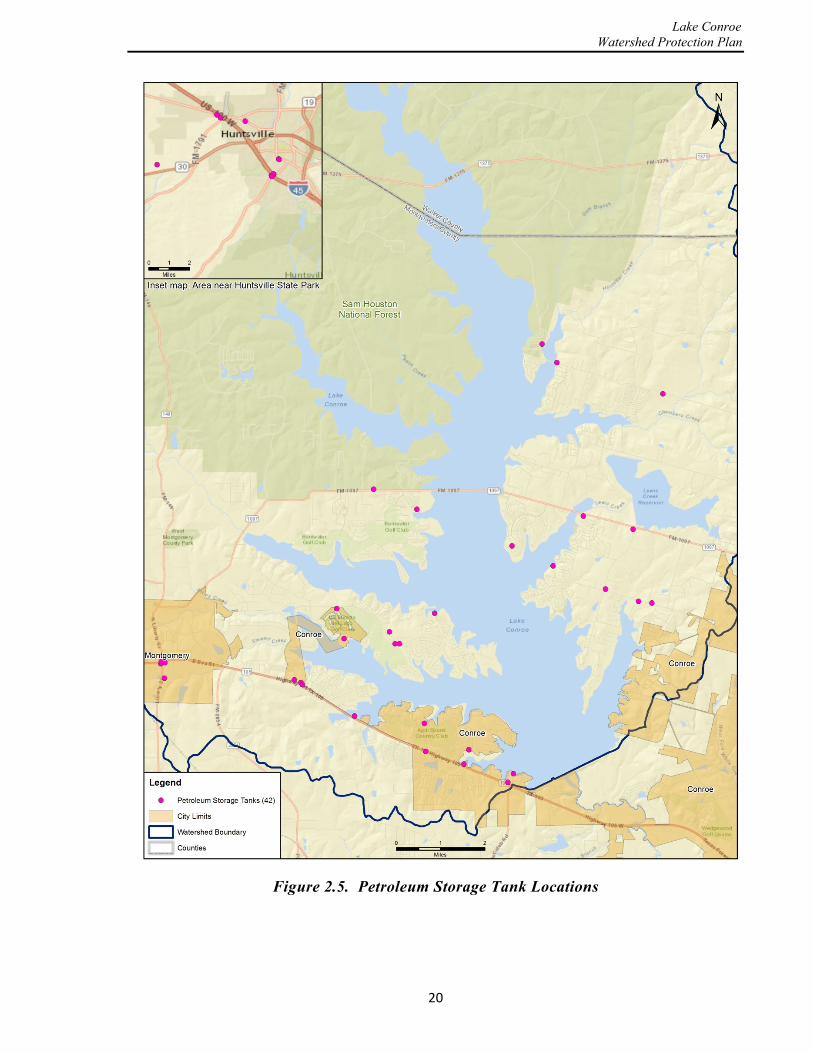
2.3.6 Petroleum Storage Tanks Regulated petroleum storage tanks (PSTs) can be found in locations throughout the watershed on the water, near the reservoir or on dry land. The PSTs that are on the water pose the biggest pollution threat due to possible leaks or breaks to the systems, which could significantly contaminate the water. The PSTs that are found on the water are usually located at marinas or gas stations located near the marinas to allow watercraft to refuel while still in the water. Spills are usually caused by customers during refueling of the watercraft. PSTs found near or away from the reservoir, but still in the watershed, are also a source of leakages or spills that can contaminate the reservoir by flowing via tributary creeks or ditches to the waterbody. The PSTs that are not directly on the water do not pose as great of a risk to contaminating the water during a spill, but can still pollute the waterbody if not caught in time. The location of PSTs in the watershed is depicted in Figure 2.5.
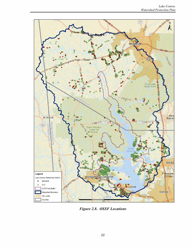
2.3.7 On-Site Sewage Facilities There are approximately 2,080 OSSFs or septic tank systems, within SJRA’s septic system jurisdiction. OSSFs are used to treat wastewater from a home or businesses and return treated wastewater back into the environment. There are also another 2,701 OSSF systems located outside the SJRA jurisdiction (but within the Lake Conroe watershed) in Walker, Montgomery, and Grimes Counties. SJRA recognizes the importance of keeping track of OSSF locations, type of system, system age and any maintenance contracts. Mapping all of the systems into a Geographic Information System (GIS) gives the opportunity for SJRA management to determine where high concentrations of OSSF systems are located and recognize areas that might have a future problem with failing OSSF systems due to age and other factors.
Conventional OSSFs allow gravity to drain wastewater to a soil adsorption field. Local soils in the Lake Conroe watershed are typically not well suited for conventional OSSF systems (i.e. septic tanks). Aerobic Treatment Units (ATU) have, therefore been replacing the conventional OSSFs and are now the most commonly used new construction OSSF system in the watershed for individual home disposal systems. Figures 2.6 and 2.7 provide illustrations of the two types of OSSFs. The TCEQ sets the minimum code for OSSFs, issues licenses to OSSF operators, delegates permitting and enforcement to local governmental entities, such as the SJRA, and periodically reviews local programs. The SJRA is the authorized agent in the Lake Conroe Water Quality Zone, which is 2,075 feet horizontally of the Lake Conroe shore at elevation 201 feet (MSL).
Figure 2.8 shows the distribution of OSSFs in the watershed and, as an example for greater detail; Figure 2.9 provides an expanded view of the OSSF locations in Grand Harbor in the southwest section of the watershed. The SJRA program consists of permitting, inspecting,
17

Lake Conroe Watershed Protection Plan
complaint investigation, and enforcement action when necessary for those OSSFs in the Water Quality Zone.
OSSF Rules require that a site and soil evaluation and a design be performed by a Sanitarian or Professional Engineer registered in the State of Texas. Upon approval of the design, the SJRA issues a construction permit. Finally, a construction inspection and approval is required in order for the SJRA to issue a license to operate the OSSF. There is a 5,000-gallon-per-day limit for OSSFs in the Lake Conroe watershed.
2.3.8 Wastewater Treatment Plants and Lift Stations There are currently 40 wastewater plants within the Lake Conroe watershed. A wastewater plant discharges its finished liquid (effluent) product through a discharge pipe, called an “outfall”. The outfalls discharge the treated effluent either into a creek or directly into Lake Conroe. Wastewater plants can cause pollution if they are not operated properly and fail to treat the wastewater as designed. Even properly-operated wastewater plants can contribute to higher than normal amounts of metals and nutrients in a water body. Figure 2.10 shows where WWTPs are located in the Lake Conroe watershed.
A wastewater lift station is a facility that pumps wastewater from a lower elevation to a higher elevation. Lift stations are common with any centralized system that is in a location with significant variations in topography. Lift stations are regulated in Texas by the TCEQ and must meet minimum design and operational standards to be legally permitted and operated. Typical of these rules is a requirement for backup power supply case of a power loss or having access to and designs for a portable generator supply. Likewise, each lift station is required to have an alarm for potential overflow of the system and a backup pump in case the primary pump was to break. There are 325 lift stations in the Lake Conroe watershed, located as depicted in Figure 2.11. Most of the lift stations in the watershed are located within the Water Quality Zone of the Lake Conroe shoreline. Lift stations by design are located at lower elevations, and if not functioning properly, may overflow directly into the lake.
18

Lake Conroe Watershed Protection Plan
Figure 2.4. Storm Drain Locations
19
Lake Conroe Watershed Protection Plan
Figure 2.5. Petroleum Storage Tank Locations
20

Lake Conroe Watershed Protection Plan
Figure 2.6. Conventional OSSF (Source: www.structural-design-solutions.com)
Figure 2.7. Aerobic Treatment Unit (Source: www.flower-mound.com)
21
Lake Conroe Watershed Protection Plan
Figure 2.8. OSSF Locations
22

Lake Conroe Watershed Protection Plan
Figure 2.9. OSSF Locations in Grand Harbor
23

Lake Conroe Watershed Protection Plan
Figure 2.10. Wastewater Treatment Plant and Outfall Locations
24

Lake Conroe Watershed Protection Plan
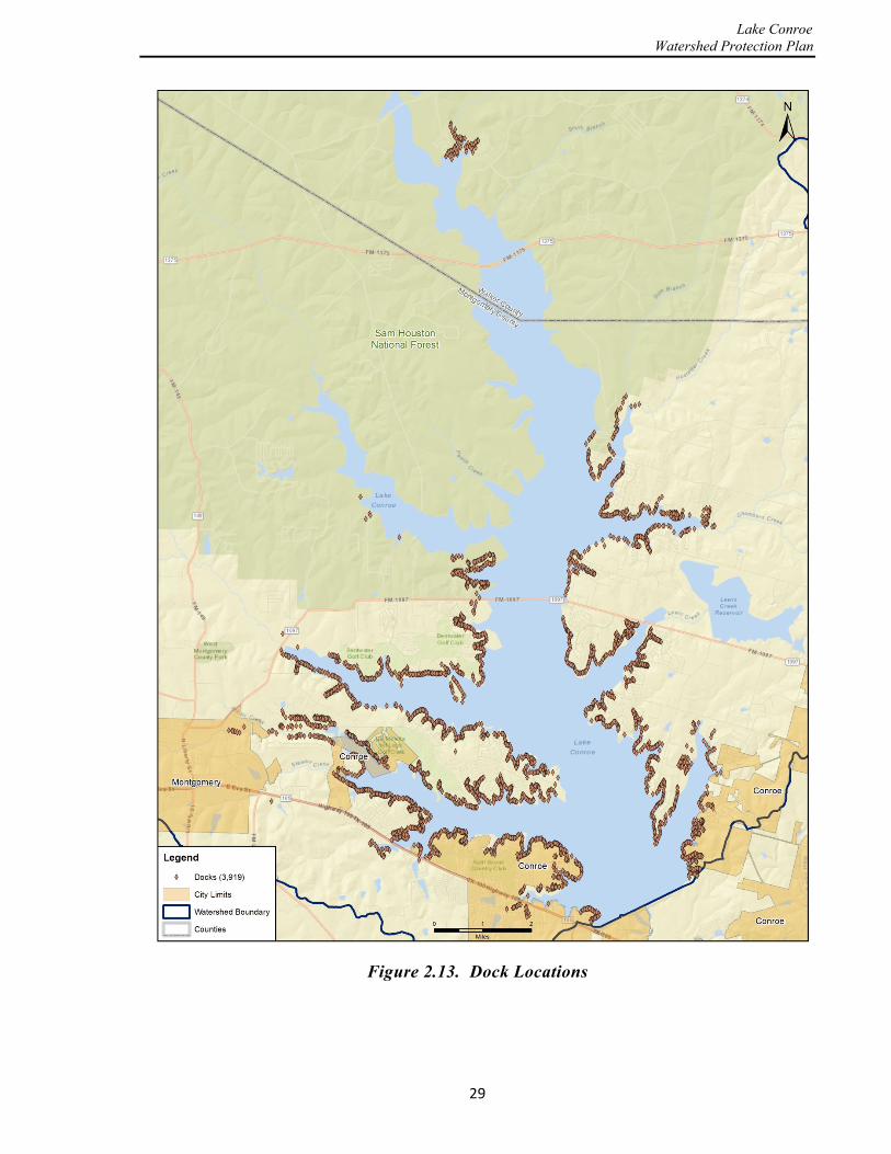
2.3.9 Recreational Activities Lake Conroe has over 110 commercial, private or public boat ramps. Boat ramps can give the public a way to enjoy Lake Conroe by personal watercraft for various recreational hobbies. Boat ramps can also potentially harm the water quality by creating an easy access point for invasive species and pollutant contamination. Invasive species are a growing problem for Lake Conroe management, and it is important to have all of the boat ramp locations identified for use in invasive species management plans.
Some of the boat ramps on Lake Conroe are located at commercial marinas. These marinas provide space for boats year-round on the water. With a high volume of boats all housed together on the water, it poses a possible threat of pollutant contamination by spills of petroleum products, trash, chemicals and wastewater from boats with waste-holding facilities. Boat ramp and marina locations are shown in Figure 2.12. Dock locations are depicted in Figure 2.13.
2.3.10 Other Potential Sources of Pollution There are several additional potential pollution sources for the Lake Conroe watershed, however, the risk associated with these sources is generally considered to be fairly minor. These other potential pollution sources include natural-gas and crude-oil pipeline, agricultural and livestock operations in the upper watershed, silvicultural (logging/forest cultivation) operations in the National Forest, and wildlife populations throughout the watershed.
Pipelines - Several oil and gas pipelines are located across Lake Conroe. Two of the pipelines carry natural gas to the Entergy power generation plant on the east side of the lake. One other major pipeline carries crude-oil beneath the lake from the north to refineries located in the Houston area. As required by the Federal Energy Regulatory Commission, each pipeline maintains an emergency spill plan. Approximately eight other cross-country petroleum product pipelines are located in the upper watershed above Lake Conroe.
Agriculture - The majority of land-use activity in the northern half of the watershed consists of small agricultural and livestock farms. These farms do not have large amounts of livestock contained in small areas, such as concentrated animal feeding operations, but instead generally have small numbers of cattle (approximately 50,000 – 60,000 head) or horses populating relatively large tracts in Montgomery and Walker Counties. The agricultural practices in the watershed can pose a threat with respect to manure and fertilizer runoff. As livestock are allowed free access to stream bed and banks, potential erosion problems can also occur.
Silviculture -The majority of silvicultural activity which occurs in the watershed is in the National Forest and is overseen by the U.S. Forest Service. All silvicultural work done on U.S. Forest Service land has to follow prescribed guidelines and practices designed in part to prevent erosion and sedimentation problems for the watershed.
25

Lake Conroe Watershed Protection Plan
Wildlife - The northern half of the watershed provides habitat for different types of native plant, insect, and larger wildlife, including white-tailed deer, multiple small mammals, and birds. Most wildlife lives in relative harmony with the ecosystem, but there are also invasive species that are found in the watershed, including feral hog. Feral hogs are found throughout the National Forest and agricultural lands in the northern part of the watershed. The population of feral hogs in the National Forest is not known. However, in 2014, TPWD estimated that the feral hog population in Texas was around 2.6 million (out of the 6 million estimated in the United States) and growing (Texas A&M AgriLife Extension, 2014). Feral hogs can cause occasional problems to water quality by waste deposition, destroying vegetation and burrowing activity near stream banks and channels.
26

Lake Conroe Watershed Protection Plan
Figure 2.11. Wastewater Lift Station Locations
27

Lake Conroe Watershed Protection Plan
Figure 2.12. Boat Ramp and Marina Locations
28
Lake Conroe Watershed Protection Plan
Figure 2.13. Dock Locations
29
Lake Conroe Watershed Protection Plan
This page is intentionally left blank
30

Lake Conroe Watershed Protection Plan
3.0 Water Quality 3.1 General The CWA defines pollution as an impairment of the beneficial uses of a water body. Therefore, water quality should be assessed based on the characteristics of the water relative to the beneficial uses of the water. Beneficial uses, which are also referred to as designated uses, are often legally defined, such as to protect public water supply, protect aquatic habitats for fish and shellfish, support wildlife, and provide for recreational, agricultural, industrial, navigational and/or aesthetic uses.
Because water quality describes the condition of the water, including its chemical, physical, and biological characteristics, with respect to its suitability for a particular purpose such as drinking or contact recreation, a number of criteria can be used to define water quality. The most common ways for defining water quality involve measurement of bacteria levels, the amount of suspended material in the water (turbidity) and the concentration of nutrients (nitrogen and phosphorus), herbicides, pesticides and other contaminants in the water. For instance, phosphorus is a component of fertilizers that enters water bodies, such as lakes, through runoff from lawns, golf courses, and agricultural land and can stimulate growth of plants and algae in the water body. Monitoring water quality data such as these are therefore critical to characterizing the watershed.
3.2 Current Monitoring Program The SJRA currently implements four distinct programs for water quality monitoring: 1) the Clean Rivers Program (CRP); 2) a tributary stream storm-event program; 3) a branch cove program; and 4) SJRA water treatment plant intake area program. Together, these programs consist of 26 different sampling locations, various different frequencies of sampling, and various types of field and laboratory measurements designed to provide an understanding of the water quality within Lake Conroe. The sampling sites for these four programs are shown in Figure 3.1 and discussed in more detail in this
The Clean Water Act defines pollution as an impairment of the beneficial uses of a water body.
SJRA implements four discrete sampling programs which together consist of 26 sampling locations, various different frequencies of sampling, and various types of field and laboratory measurements.
31

Lake Conroe Watershed Protection Plan
section. Each of these four programs mentioned above will be monitored on an ongoing basis, and the scope and frequency of sampling will be modified to maximize the effectiveness of the overall program.
3.2.1 Clean Rivers Program The SJRA participates in and contributes to the CRP by sampling Lake Conroe and its tributaries water at various designated sites on a monthly basis. The collected water quality samples are transported and delivered to the City of Houston’s Water Quality Laboratory for analysis. The CRP is managed regionally by the H-GAC. The H-GAC collects all field and laboratory data from the various CRP participants and disseminates the information through its website www.h-gac.com.
The Texas CRP, established by the Texas State Legislature through the Texas Clean Rivers Act of 1991, is a partnership between the TCEQ and regional water authorities throughout the state to coordinate and conduct water quality monitoring, assessment, and stakeholder participation in order to improve the quality of surface water within each river basin in Texas. The CRP uses a watershed management approach to identify and evaluate water quality issues, establish priorities for corrective action, and work to implement those actions. Fifteen regional water authorities, including twelve river authorities, one water district, one council of government, and an international water commission, have contracts with the TCEQ to conduct water quality monitoring, assessment, and stakeholder outreach in the 23 major river and coastal basins of Texas. The H-GAC is the lead assessment agency for the San Jacinto River basin. The H-GAC also oversees the CRP in the Trinity-San Jacinto, San Jacinto-Brazos, and Brazos-Colorado coastal basins.
Working through the H-GAC, the SJRA and the City of Houston operate a network of 10 water quality monitoring stations in the Lake Conroe watershed as shown in Figure 3.1. The CRP sites are all located in the main body of the lake and have many years of data collected from these sites.
3.2.2 Storm Event Program One of the goals of this Plan was to extend the range of the water quality sampling to encompass the entire watershed. The SJRA has good data from the CRP for the water quality in the main body of Lake Conroe, but less is known about the quality of the water as it immediately enters the reservoir from the various tributaries; therefore, a storm-event sampling program was recently established to capture water samples within major tributaries of the watershed. For the period from January 2013 to present, eight monitoring sites, as depicted in Figure 3.1, were established near the discharge locations for the main tributaries into the reservoir.
3.2.3 Branch Cove Program There was also a need to improve the understanding of the general water quality within the isolated branch coves of Lake Conroe that are formed by property owner’s dredging within the
32

Lake Conroe Watershed Protection Plan
Figure 3.1. Water Quality Sampling Site Locations
33

Lake Conroe Watershed Protection Plan
numerous small tributaries around the reservoir. These cove areas are known to have very little mixing from wind and boat activity due to the small size of the coves and the shallow depth of the water. The higher summer temperatures also create a higher potential for bacterial problems in these coves. Eight sites have been sampled since November 2012 in order to gain a better understanding of the water quality in the cove areas of the lake and additional sampling should improve this understanding in the future. These sites are also shown in Figure 3.1. Eight sites were selected near the headwaters of the feeding tributaries in areas that do not receive a lot of mixing. Sites 2 through 7 are located upstream from the CRP sites. Sites 1 and 8 are located on branches of the reservoir that are not regularly sampled.
3.2.4 SJRA Water Treatment Plant Intake Program The intake structure at the Lake Conroe Dam is the location of the pumps that will be transferring raw water to the SJRA water treatment plant. Since the water plant is new and there is limited history of water quality data from the pumping location, there was a need for additional sampling to be conducted at this site.
3.3 Monitoring Frequency and Procedures 3.3.1 Sample Frequency Water quality monitor sampling by the SJRA is conducted at three different frequencies (daily, monthly, and quarterly). The frequency is varies for each of these programs based on the amount of resources available.
Daily - The intake sampling program at the Lake Conroe dam is currently conducted three days out of each work week for specific parameters. These samples are taken to an SJRA laboratory located in the Lake Conroe Division Office and processed by Water Quality Department staff.
Monthly - The CRP provides sampling and monitoring by the SJRA on a monthly basis, with the chemical and biological analyses provided by the City of Houston at their laboratory. Some parameters for the special intake sampling program are also monitored on a monthly basis. These later samples are processed at an external laboratory.
Quarterly - The storm-event sites are sampled once per quarter during storm events when rainfall is approximately one inch or greater in the surrounding watershed. The storm-event and branch cove program sampling is performed quarterly in order to observe the impact of typical storms on water quality and the seasonal variations in water quality within the coves, respectively.
3.3.2 Parameters and Standards The water quality samples that are collected in the SJRA monitoring programs are analyzed for various constituents, as presented in Table 3.1. These constituents selected for analysis provide a characterization of the raw water quality in Lake Conroe and potentially give indications of
34

Lake Conroe Watershed Protection Plan
possible water quality issues that may need to be addressed in the future. The TCEQ standards and screening levels are presented in Table 3.2. The parameters within the State standards are established by the TCEQ based on water quality problems that affect human and ecological health. The state water quality standards were created within the EPA Clean Water Act of 1973 based on a “designated use”. The three designated uses for Lake Conroe are water supply, primary contact recreation, and aquatic life. TCEQ also has a set of screening levels that are not standards or laws, but are instead recommended levels designed to reduce the risk of health or ecological problems. The additional constituents included within this program by SJRA were selected based on the desire to identify any additional pollutants that might be entering into Lake Conroe and the need to better understand the water chemistry for efficient operation of the GRP water treatment facility located at the Lake Conroe Dam.
The EPA and TCEQ provide detailed Quality Assurance and Quality Control procedures for field sampling and data entry adopted from the Surface Water Quality Manual (refer to TCEQ (2012)). The SJRA follows all of these required guidelines during field sampling, equipment calibrations, and data entry. The laboratory Quality Assurance and Quality Control process follows the guidelines found in the widely accepted Standard Methods for the Examination of Water and Wastewater, (Eaton, A.D. et al, 2005). The standard methods provide the detailed process for processing each sample through the laboratory. Quality-control in the laboratory is also conducted by properly calibrating the laboratory equipment on a routine basis.
35
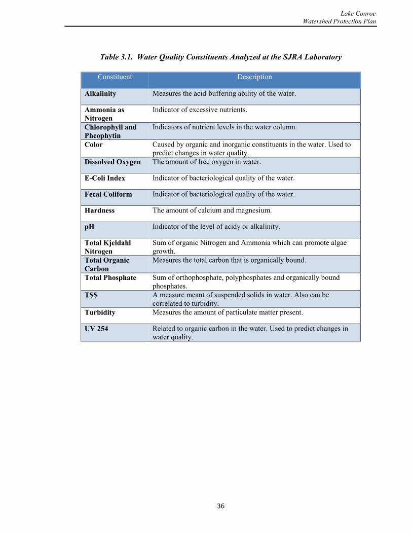
Lake Conroe Watershed Protection Plan
Table 3.1. Water Quality Constituents Analyzed at the SJRA Laboratory
Constituent Description
Alkalinity Measures the acid-buffering ability of the water.
Ammonia as Nitrogen
Indicator of excessive nutrients.
Chlorophyll and Pheophytin
Indicators of nutrient levels in the water column.
Color Caused by organic and inorganic constituents in the water. Used to predict changes in water quality.
Dissolved Oxygen The amount of free oxygen in water.
E-Coli Index Indicator of bacteriological quality of the water.
Fecal Coliform Indicator of bacteriological quality of the water.
Hardness The amount of calcium and magnesium.
pH Indicator of the level of acidy or alkalinity.
Total Kjeldahl Nitrogen
Sum of organic Nitrogen and Ammonia which can promote algae growth.
Total Organic Carbon
Measures the total carbon that is organically bound.
Total Phosphate Sum of orthophosphate, polyphosphates and organically bound phosphates.
TSS A measure meant of suspended solids in water. Also can be correlated to turbidity.
Turbidity Measures the amount of particulate matter present.
UV 254 Related to organic carbon in the water. Used to predict changes in water quality.
36

Lake Conroe Watershed Protection Plan
Table 3.2. EPA Maximum Contaminant Levels
Parameter Criterion Type Standard or Screening Level
Ammonia-N 2010 TCEQ Screening Level
0.11 mg/L
Chloride 2010 EPA Water Quality Standard
50 mg/L
Chlorophyll a 2010 TCEQ Screening Level
26.7 Micrograms/L
Dissolved Oxygen (minimum 24-hour mean)
2010 EPA Water Quality Standard
5.0 mg/L
Dissolved Oxygen (single sample minimum)
2010 EPA Water Quality Standard
3.0 mg/L
E. Coli 2010 EPA Water Quality Standard
126 MPN/100 mL
Nitrate-N 2010 TCEQ Screening Level
0.37 mg/L
Orthophosphate-P 2010 TCEQ Screening Level
0.05 mg/L
Sulfate 2010 EPA Water Quality Standard
50 mg/L
Temperature 2010 EPA Water Quality Standard
90 Degrees F
Total Dissolved Solids 2010 EPA Water Quality Standard
300 mg/L
Total Phosphorus 2010 TCEQ Screening Level
0.2 mg/L
37

Lake Conroe Watershed Protection Plan
3.4 Water Quality Data The data presented in this section’s tables are displayed as mean values over the most recent representative period of data for each site. The last column in each table provides the appropriate stream standard that the EPA and TCEQ have established, if any, for that particular identified constituent under the approved Texas Surface Water Quality Standards. If there is no standard for a constituent, it is marked as “not available” (NA). If there is a parameter that is tested but cannot be detected in the sample, it is marked “non-detectable” (ND). Sampled reservoir constituent data when compared against these tables, provides confirmation that the water in Lake Conroe is currently of good quality. Further confirmation is provided by the fact that Lake Conroe is not included on the state’s list of impaired water bodies (Section 303(d) of the federal Clean Water Act).
3.4.1 CRP Data The CRP data is the most representative and statistically accurate of all water quality data available for Lake Conroe due to the long period of record. Table 3.3 provides a summary of
the data as an average (mean) for the last four years. This particular monitoring program has been ongoing for over 40 years and shows similar excellent water quality data for the entire period. Figures 3.2 through 3.5 graphically depict a selected set of water quality data from the CRP, showing trend lines and the reference standard. Each graph represents a different
constituent at three different sampling locations. The three sampling locations were selected to best represent the major regions of the lake, including one sampling location in a northern part of the reservoir at the FM 1375 bridge, the second near the center of the reservoir at the FM 1097 bridge, and another at a downstream location near the Lake Conroe Dam. The red line on each graph represents the standard and the dotted blue line on some of the figures represents the statistical trend of the available data for this 4-year period.
Nitrate and phosphorus (nutrient) levels in Lake Conroe over the period from July 2010 to January 2014 are depicted in Figures 3.2 and 3.3. Except for the peaks occurring during the recent 2010-2012 drought which are observable at the northern reach of the lake, the nutrient levels are relatively low and represent good water quality.
Water quality monitoring data collected from the lake by H-GAC (2011) indicated good water quality with the exception of chlorophyll-a. Figure 3.4 illustrates this issue, as indicated by the high concentration values with peaks exceeding the standard between July, 2008, and October, 2009. However, additional monitoring of the upper watershed may be necessary to adequately portray water quality throughout the watershed. (H-GAC, 2011)
The SJRA monitoring program has been ongoing for over 40 years and shows similar excellent water quality data for the entire period.
38
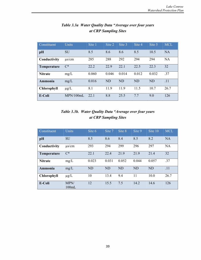
Lake Conroe Watershed Protection Plan
Table 3.3a Water Quality Data “Average over four years at CRP Sampling Sites
Constituent Units Site 1 Site 2 Site 3 Site 4 Site 5 MCL
pH SU 8.5 8.6 8.6 8.5 10.5 NA
Conductivity µs/cm 285 288 292 294 294 NA
Temperature C* 22.2 22.9 22.1 22.5 22.3 32
Nitrate mg/L 0.060 0.046 0.014 0.012 0.032 .37
Ammonia mg/L 0.016 ND ND ND ND .11
Chlorophyll µg/L 8.1 11.9 11.9 11.5 10.7 26.7
E-Coli MPN/100mL 22.1 8.8 25.5 7.7 9.0 126
Table 3.3b. Water Quality Data “Average over four years at CRP Sampling Sites
Constituent Units Site 6 Site 7 Site 8 Site 9 Site 10 MCL
pH SU 8.5 8.6 8.4 8.5 8.2 NA
Conductivity µs/cm 293 294 299 296 297 NA
Temperature C* 22.1 22.4 21.9 21.9 21.4 32
Nitrate mg/L 0.023 0.031 0.052 0.044 0.057 .37
Ammonia mg/L ND ND ND ND ND .11
Chlorophyll µg/L 10 13.4 9.4 11 10.0 26.7
E-Coli MPN/ 100mL
12 15.5 7.5 14.2 14.6 126
39

Lake Conroe Watershed Protection Plan
Figure 3.2. Nitrate Concentrations over a 4-Year Span at Three Locations in Lake Conroe
Figure 3.3. Phosphorus Concentrations over a 4-Year Span at Three Locations in Lake Conroe
40

Lake Conroe Watershed Protection Plan
Figure 3.4. Chlorophyll-a Concentrations over a 4-Year Span at Three Locations in Lake Conroe
Figure 3.5. Chloride Concentrations over a 4-Year Span at Three Locations in Lake Conroe
41
Lake Conroe Watershed Protection Plan
3.4.2 Storm Event Data This sampling program is fairly new and therefore only a short period of quarterly data (approximately two years) is available. Further compounding the interpretation of this data is the fact that each event sampled represents a single “grab” sample taken of a flowing stream during a storm event in that quarter. The concentration of the water quality constituents analyzed under this program is known to vary significantly throughout a single storm event. However, it does provide a snapshot of the incoming water quality at the various tributary streams.
The data presented in Table 3.4 is the average for this two-year period for the eight sites in the storm event sampling program. As would be expected, the concentrations for several parameters are slightly higher than those nearby sampling sites within the reservoir and sometimes surpass the standard. This is not surprising since initially high concentrations of pollutants often occur in storm water runoff, especially for the first flush of runoff early within a storm event. Within a reservoir impoundment such as Lake Conroe, there is a rapid die-off of the bacteria due to temperature and sunlight penetration into the water column and the storm runoff is quickly mixed within this shallow reservoir so it is difficult to detect the results of a recent storm event within 2-3 days after the storm. Plant life and algae also create a demand for nutrients which can cause reductions in those constituents over time as well.
3.4.3 Branch Cove Data One of the newest monitoring programs was initiated recently to determine whether the reservoir water quality varied significantly as sampling sites were moved from the main body of the reservoir into the various branch or arms of the reservoir. At this time, there are only four quarterly samples which have been monitored under this program. As shown in Table 3.5, the water quality is very consistent across the multiple arms of the reservoir and is quite similar to the quality shown in the main body of the reservoir. This data is still very limited but is useful for comparison purposes to better understand the reservoir mixing and general changes as water moves from the upstream area to the downstream area of the lake.
3.4.4 Raw Water Intake Data This intake sampling program contains the most extensive range of water quality constituents that has been monitored for Lake Conroe in its entire history. Although only sampled at a single site (the intake area) for a relatively recent five-year period, this raw water intake monitoring program has provided very extensive data for many additional constituents within Lake Conroe. The average concentrations for all constituents sampled over the two-year period are shown in Table B.1 in Appendix B. As would be expected, the concentration levels for pesticides, herbicides, organic chemicals, heavy metals, and many other pollutants of concern are all extremely low or are completely undetectable using the approved EPA analysis techniques. For this reason, continued sampling at the intake will be significantly reduced and limited to key parameters of concern to the water treatment processes in the future.
42
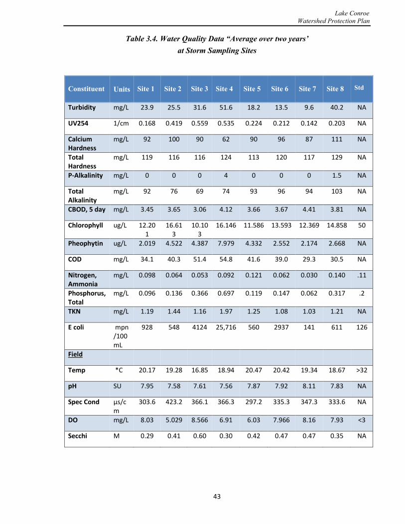
Lake Conroe Watershed Protection Plan
Table 3.4. Water Quality Data “Average over two years’
at Storm Sampling Sites
Constituent
Units
Site 1
Site 2
Site 3
Site 4
Site 5
Site 6
Site 7
Site 8
Std
Turbidity mg/L 23.9 25.5 31.6 51.6 18.2 13.5 9.6 40.2 NA
UV254 1/cm 0.168 0.419 0.559 0.535 0.224 0.212 0.142 0.203 NA
Calcium Hardness
mg/L 92 100 90 62 90 96 87 111 NA
Total Hardness
mg/L 119 116 116 124 113 120 117 129 NA
P-Alkalinity mg/L 0 0 0 4 0 0 0 1.5 NA
Total Alkalinity
mg/L 92 76 69 74 93 96 94 103 NA
CBOD, 5 day mg/L 3.45 3.65 3.06 4.12 3.66 3.67 4.41 3.81 NA
Chlorophyll ug/L 12.201
16.613
10.103
16.146 11.586 13.593 12.369 14.858 50
Pheophytin ug/L 2.019 4.522 4.387 7.979 4.332 2.552 2.174 2.668 NA
COD mg/L 34.1 40.3 51.4 54.8 41.6 39.0 29.3 30.5 NA
Nitrogen, Ammonia
mg/L 0.098 0.064 0.053 0.092 0.121 0.062 0.030 0.140 .11
Phosphorus, Total
mg/L 0.096 0.136 0.366 0.697 0.119 0.147 0.062 0.317 .2
TKN mg/L 1.19 1.44 1.16 1.97 1.25 1.08 1.03 1.21 NA
E coli mpn/100mL
928 548 4124 25,716 560 2937 141 611 126
Field
Temp *C 20.17 19.28 16.85 18.94 20.47 20.42 19.34 18.67 >32
pH SU 7.95 7.58 7.61 7.56 7.87 7.92 8.11 7.83 NA
Spec Cond µs/cm
303.6 423.2 366.1 366.3 297.2 335.3 347.3 333.6 NA
DO mg/L 8.03 5.029 8.566 6.91 6.03 7.966 8.16 7.93 <3
Secchi M 0.29 0.41 0.60 0.30 0.42 0.47 0.47 0.35 NA
43
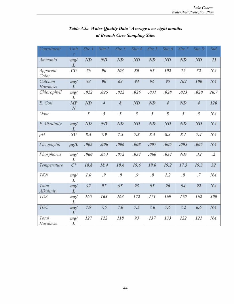
Lake Conroe Watershed Protection Plan
Table 3.5a Water Quality Data “Average over eight months at Branch Cove Sampling Sites
Constituent Units
Site 1 Site 2 Site 3 Site 4 Site 5 Site 6 Site 7 Site 8 Std
Ammonia mg/L
ND ND ND ND ND ND ND ND .11
Apparent Color
CU 76 90 103 80 95 102 72 52 NA
Calcium Hardness
mg/L
93 90 63 94 96 95 102 100 NA
Chlorophyll mg/L
.022 .025 .022 .026 .031 .028 .023 .020 26.7
E. Coli MPN
ND 4 8 ND ND 4 ND 4 126
Odor 5 5 5 5 5 8 5 5 NA
P-Alkalinity mg/L
ND ND ND ND ND ND ND ND NA
pH SU 8.4 7.9 7.5 7.8 8.3 8.3 8.1 7.4 NA
Pheophytin µg/L .005 .006 .006 .008 .007 .005 .005 .005 NA
Phosphorus mg/L
.060 .053 .072 .054 .060 .054 ND .12 .2
Temperature C* 18.8 18.4 18.6 19.6 19.0 19.2 17.5 19.3 32
TKN mg/L
1.0 .9 .9 .9 .8 1.2 .8 .7 NA
Total Alkalinity
mg/L
92 97 95 93 95 96 94 92 NA
TDS mg/L
165 163 163 172 171 169 170 162 300
TOC mg/L
7.9 7.5 7.0 7.5 7.6 7.6 7.2 6.6 NA
Total Hardness
mg/L
127 122 118 93 137 133 122 121 NA
44

Lake Conroe Watershed Protection Plan
Table 3.5b. Water Quality Data “Average over eight months
at Branch Cove Sites
Constituent Units Site 1 Site 2 Site 3 Site 4 Site 5 Site 6 Site 7 Site 8 Std
TSS mg/L 9.15 7.4 10 7.1 7.5 12.8 7.1 6.6 NA
True Color CU 25 21 19 16 19 15 21 12.5 NA
Turbidity mg/L 5.2 6.1 6.8 5.0 4.8 7.7 4.7 3.1 NA
UV254 1/cm .158 .133 .133 .137 .141 .135 .136 .126 NA
Cond µs/cm 352.5 327.1 331 330.4 323.5 316.3 328.1 327.1 NA
DO mg/l 8.3 10.3 6.8 8.2 9.7 9.3 9.4 8.3 <3
45
Lake Conroe Watershed Protection Plan
This page is intentionally left blank
46

Lake Conroe Watershed Protection Plan
4.0 Management Activities
4.1 General The purpose of this section of the report is to summarize the management activities that the SJRA wishes to consider in order to implement and achieve the goals of this Plan. Some of these activities are already in various stages of implementation by SJRA while others are proposed activities that will require further consideration and stakeholder input prior to implementation. Management activities have been selected based on identified potential sources of pollution which have a significant risk of occurrence in the future given the characteristics of the Lake Conroe watershed. These management activities are designed to be conducted by SJRA’s professional staff. Most of these activities are grouped into three broad categories with respect for timing.
• Ongoing management activities that are expected to continue into the future, all of which may be re-evaluated, enhanced, or modified appropriately depending on future conditions.
• New management activities which have been identified/selected as a result of the development of this Plan and which are believed to warrant consideration for near-term development (i.e., next five years).
• Future management activities which are known to offer the potential to reduce risks associated with the various sources of pollution into Lake Conroe and which may be considered for long-term development and implementation (beyond five years) as resources and funding become available.
Most of these management activities are designed to reduce the risk of future pollution in the watershed which often requires a change in the behavior of the originator of that potential pollution. Therefore, the effectiveness of each activity is enhanced considerably by the public’s understanding and appreciation of the expected benefits to water quality which will result from that change in behavior. For this reason, public education and outreach activities are a
foundational requirement to the successful implementation of these management activities. These important educational activities are discussed in more detail in Section 5 of this report.
These management activities are designed to reduce the risk of future pollution and their effectiveness is enhanced by the public’s understanding of the benefits. For this reason, public education and outreach are a foundational requirement to successful implementation.
47
Lake Conroe Watershed Protection Plan
Additionally, many of the management activities proposed within this report require significant cooperation and assistance from other public agencies and local private organizations within the watershed in order to successfully accomplish the goals of the activity. The SJRA will
continue to work closely with these diverse groups to maximize the opportunities for success of each activity. The existing Stakeholder Group will be requested to continue its involvement with the SJRA as the Plan is further developed and implemented and that Stakeholder Group will be expanded as required to address any specific areas of concern.
The primary sources for future pollution in the Lake Conroe watershed were characterized in Section 2 of this report and are summarized below.
• Stormwater runoff from the surrounding and expanding urbanized development around Lake Conroe.
• Nutrient and bacteria levels from existing overloaded and/or poorly performing WWTP facilities.
• Bacteria from sanitary sewer overflows, pet and wildlife waste, and malfunctioning OSSFs.
• Silt and debris from construction sites within the high-growth areas of the watershed. • Litter and waste from roadways, commercial areas, and aquatic recreational activities.
The management activities to be considered to address these sources of pollution will therefore include a wide range of measures such as the following: 1) improving stormwater controls in new developments and retro-fitting the controls in older developments; 2) managing the OSSFs more stringently; 3) improving compliance and enforcement of existing stormwater quality permitting; 4) continuing public education and outreach with respect to nutrients and their consequences; and 5) reducing or properly managing fertilizer runoff from residential lawns as well as from the agricultural areas that are located primarily in the northern portion of the watershed.
4.2 Ongoing Activities The SJRA currently conducts multiple management activities that are within the Authority’s jurisdiction and that contribute to the maintenance and enhancement of the current good water quality within the Lake Conroe watershed. These activities are outlined below and are expected to continue in the future. Much of the work associated with these activities is conducted in conjunction with other jurisdictional entities within the watershed and this interaction and cooperative effort is also expected to continue.
4.2.1 Monitoring Water Quality The extensive Lake Conroe water quality monitoring program conducted by SJRA was outlined in Section 3. This management activity will continue into the future. The water quality data collected under this Plan serve as the foundation for detecting future changes or trends in the
48

Lake Conroe Watershed Protection Plan
fundamental water quality within the reservoir. The water quality monitoring program also serves to detect any specific violations of surface water quality standards that may require immediate detailed investigation or action. The collection of frequent samples over a wide geographic area and the analysis of the wide range of water quality parameters create the single
most expensive element of the watershed protection management activities currently being provided by the SJRA for Lake Conroe. The scope and breadth of this water quality monitoring program is subject to change to maximize its value to the Plan.
4.2.2 Maintaining the Watershed Protection Plan This Plan will be periodically reviewed, revised, and updated with the most current information by the SJRA and its stakeholders. As ongoing activities are implemented and as miscellaneous new management activities are developed in the future, these activities will be documented and appended to this report in order to provide a consolidated and summarized record of those activities. Approximately every five years, a formal plan update will be developed and published by the SJRA to reflect the latest conditions and the ongoing and proposed management activities that are currently under implementation. Therefore, the Plan will be a living document that will be periodically revised to meet the needs of program and the watershed stakeholders and to address both short- and long-term goals to improve water quality in the Lake Conroe watershed.
4.2.3 On-Site Sewage Facility Program One of the more important ongoing management activities related to water quality is the existing OSSF Program that SJRA has operated since Lake Conroe was initially constructed. The OSSF Program encompasses the area around Lake Conroe designated as the Water Quality Zone, which is located within 2,075 feet measured horizontally from the 201-ft MSL lakeshore contour line. Within this designated area in both Walker and Montgomery Counties, the TCEQ has delegated authority to SJRA to serve as the Authorized Agent on behalf of the State of Texas to operate the OSSF Program in accordance with Chapters 285 and 366 of the Health and Safety Code and Chapters 7 and 37 of the Texas Water Code. The SJRA ensures compliance with these State rules and regulations by: reviewing designs, issuing permits, inspecting the constructed facilities, investigating complaints, instituting enforcement action when necessary, and providing the official regulatory record-keeping for the State. Outside of the Water Quality Zone, Walker and Montgomery County serve as the Authorized Agents for the OSSF Program in their respective counties.
Initially, the majority of OSSFs installed within the Water Quality Zone used the conventional septic tank and drain-field systems. ATUs were introduced in the late 1980s and were required to be installed in areas with poor soil conditions or in areas with a high seasonal water table. Unlike the conventional systems which must percolate all wastewater underground through infiltration into the soil, the ATU utilizes additional treatment processes to achieve secondary treatment, which produces an effluent suitable for disposal by spray irrigation. TCEQ rules require ATUs in situations where old conventional systems have failed and where tests show
49

Lake Conroe Watershed Protection Plan
poor soil conditions or a high water table to exist. Through subsequent years, many conventional systems around Lake Conroe have been required to be replaced with ATUs because of their poor performance. Most remaining undeveloped areas that propose large lot sizes and wish to use OSSFs are also required to use ATUs due to the typical soil types found
in these areas. About two thirds of all OSSFs around Lake Conroe are now ATUs. When a new ATU is installed, the rules require that homeowners enter into a two-year maintenance contract with a certified maintenance provider to operate and maintain the ATU. Unfortunately, in 2009, the TCEQ dropped the requirement for single-family dwellings to have ongoing maintenance after the initial two years. This condition creates a major concern which is addressed in Section 4.3.
4.2.4 Runoff from Urbanized Areas While a significant portion of the Lake Conroe watershed consists of undeveloped forest and grassland, limited but dense urban and suburban areas have developed in the past decades adjacent to Lake Conroe and the City of Huntsville. With continuing increased urbanization in the watershed and the corresponding increase in impervious surfaces, Lake Conroe and its tributaries may become more and more impacted by the potential degrading effects of urban stormwater runoff. If it is not already, urban runoff could become the leading source of pollution causing water quality impairment related to human activities in the Lake Conroe watershed. For any development seeking to discharge stormwater directly into Lake Conroe, the SJRA has recently instituted a practice of requiring facilities to be installed within the development to physically limit the amount of pollutants in that stormwater runoff. There are multiple methods available to achieve a reduction in pollution from these direct discharges and SJRA requires the development to use one or more of these techniques whenever possible. This practice will continue and potentially be enhanced in the future (See Section 4.3).
4.2.5 Public Education The single most important opportunity for maintaining and improving the quality of water within the Lake Conroe watershed is a function of the public’s understanding and appreciation of the impact that their actions may have on water quality. Whether it is properly disposing of household wastewater, trash, pet waste, toxic chemicals, or improper use of lawn-care products, the impact of these personal activities cannot be over-emphasized. The SJRA recognizes its important role of creating educational materials and supporting special events that help keep our community aware of the importance of these individual actions. Education and outreach activities supporting the Plan are ongoing and will continue. These public education activities are designed to reach a wide range of audiences and to cover multiple topics and are further outlined in Section 5 of this report.
4.2.6 Shoreline Mitigation and Aquatic Vegetation Control Since the early 1980s, Lake Conroe has experienced varying degrees of infestation from non-native plant species. Non-native, or nuisance, aquatic plants disrupt the natural ecology of lakes and reservoirs and can significantly reduce the health of these systems. Desirable shoreline
50
Lake Conroe Watershed Protection Plan
ecosystems consist of diverse plant populations made up of primarily native species that are well adapted to the soil and climatic conditions of the area.
Throughout the years, the SJRA, through consultation with the TPWD, has taken an integrated management approach to controlling non-native species. This approach has included physical removal, herbicide treatments with EPA-approved aquatic herbicides, use of biological control agents, and shoreline restorative plantings with native plants. SJRA has also partnered with other governmental agencies, public and private organizations, area businesses, local residents, and civic organizations to accomplish its goals.
One biological control agent historically chosen for use on Lake Conroe is the Asian grass carp or white amur (Ctenopharyngodon idella). These fish are very effective at controlling certain non-native plant species, especially hydrilla (Hydrilla verticillata). Unfortunately, they can also consume many native species and have the potential to leave reservoirs virtually void of aquatic plants. This has happened twice in the history of Lake Conroe. The goal is to maintain just enough grass carp to prevent overpopulation of undesirable species while simultaneously maintaining a wide variety of native species. The key is to have plentiful populations of species that are not favored by grass carp and can thus survive and expand even though grass carp are present in adequate numbers to keep hydrilla under control. Research into carp-resistant species is on-going. Both scientific and anecdotal evidence suggest that the water willow (Justicia Americana) is a plant well suited to provide suitable habitat for micro- and macro-invertebrates as well as many fish species. This plant also assists with shoreline stabilization and nutrient filtering. SJRA and its partners have already planted some five miles of Lake Conroe shoreline with a variety of grass carp-resistant native plants with a focus on water willow and have plans to expand this effort into other areas of the reservoir. As research continues, future efforts will include the best available technology to establish native aquatic plant species specifically selected for their survival tendencies and overall ecological benefits. Observations will be made as to their effectiveness in resisting grass carp predation and the program will be adjusted accordingly.
4.2.7 Solid Waste Management Solid waste, which is commonly known as trash or garbage, can be a common environmental problem in a watershed. Solid waste poses many problems, such as health issues, pollution, environmental damage to wildlife habitats, and aesthetic-value degradation. Solid waste may be defined as anything from car batteries leaking acid to plastic shopping bags littering the sides of the road. Solid waste in the Lake Conroe watershed is evident in many places, such as floating trash or “floatables” within the upper reaches of Lake Conroe, especially in the coves, or may appear in the form of illegal trash dumps within the National Forest or other rural areas of the watershed.
The “Rivers, Lakes, Bays ‘N Bayous Trash Bash” program is an existing program that has been operating in the watershed for several years now. The program helps educate the public on the magnitude of this problem and gives the public the opportunity to give back and help the local governing agencies in cleaning up trash around the lake. The program has been successful at
51

Lake Conroe Watershed Protection Plan
removing tires, beer bottles, and other forms of illegal dumping in the national forest. When Lake Conroe was at its recent low level in 2011, the program enabled the removal of trash along the newly exposed shoreline. SJRA plans to continue to support this beneficial program.
4.3 New Activities In addition to continuing the ongoing activities related to water quality as described above, the SJRA expects to expand and improve many of these programs in order to achieve greater effectiveness and value from these activities. More detailed evaluation of these potential improvements will be required by the SJRA over the next 5-year period in order to develop a better understanding of the potential costs, resources, schedules, and methods of evaluating effectiveness. Many of these new activities will also require cooperation of other public agencies and participation of various stakeholders to help refine and implement the programs. More details regarding the anticipated schedule of activities is provided in Section 6 of this Report.
4.3.1 Regulatory Changes for the OSSF Program OSSF systems, when designed, operated, and maintained properly, provide an efficient and economical method for disposal of residential household wastewater. However, failure of an OSSF within the 2,075 foot Water Quality Zone creates a high risk for partially and inadequately treated wastewater to enter into Lake Conroe. Although the volumes of wastewater are usually small for such events, this can pose significant risk for recreational users of the lake in the immediate area. The majority of the causes for failing ATU systems include: failed aerator pumps, clogged aerator filters, broken air lines, stopped up diffusers, failed irrigation pumps, malfunctioning electrical circuits, clogged backwash filters, over-accumulation of sludge and broken sprinklers. The majority of the causes for failing gravity or conventional systems include: over-accumulation of sludge in the septic tanks, carry-over of sludge into the field lines due to not periodically pumping the tanks, crushed field lines, broken tank lids, sewage surfacing to the ground due to overloading or root infested field lines, and stoppage of the flow in field lines due to a biological mat. SJRA, in its role as the OSSF Authorized Agent for the State within the Water Quality Zone of Lake Conroe, observes frequent and multiple failures of these systems.
The most common problems associated with OSSF systems are operation and maintenance issues as outlined above. Upon justification and approval by TCEQ, Authorized Agents can amend their OSSF orders to include more stringent requirements than those required by the TCEQ. On this basis, the SJRA is evaluating appropriate amendments to its OSSF Order and anticipates some significant changes will be considered within FY 2016. The potential amendments to the OSSF Order would be similar to the more stringent requirements already adopted by Montgomery and Walker counties which now are in effect for areas outside of the Lake Conroe Water Quality Zone. All of the proposed amendments to the OSSF Order under consideration are outlined in Appendix C. Most deal with OSSF design criteria. However, one
52

Lake Conroe Watershed Protection Plan
of the more significant changes also being considered is an amendment to require all ATUs to be operated and maintained by a licensed maintenance provider. Many homeowners already comply with this provision by using a licensed provider beyond the current two-year minimum required for new installations; unfortunately, some homeowners do not maintain these contracts and do not maintain their systems to the proper level of compliance. SJRA is therefore considering an amendment requiring that all ATU systems be maintained by a licensed maintenance provider or by a resident homeowner that has been certified and licensed by the TCEQ, as explained further below.
Under the proposed amendments, property owners who wish to do their own maintenance may do so provided they can produce and submit to SJRA a valid certificate of completion of either: 1) the Basic Maintenance Provider Course offered by the Texas Onsite Wastewater Association, or 2) the Aerobic/Surface Application O&M Course offered by the Texas Engineering Extension Service, or 3) a valid TCEQ Class-D Wastewater License, or 4) an equivalent course approved by the TCEQ and SJRA. These property owners will be required to enter into a written agreement with SJRA that they will comply with all inspection, testing, and reporting requirements as determined by SJRA. Property owners who fail to submit required inspection reports shall forfeit their authority to self-maintain their aerobic system and will be required instead to obtain a contract for maintenance of their system by a licensed maintenance provider.
In conjunction with the proposed amendments, increased inspections and audits of the maintenance and operation of these systems are also being considered. SJRA currently has approximately 2,000 OSSFs in its jurisdiction, of which about 600 are conventional and 1,400 are ATUs. If these systems are audited annually, SJRA will need to perform about 40 inspections per week or eight per day; therefore, the cost would be significant. Multiple options for scaled implementation and funding will be investigated as a part of this determination and implementation planning.
4.3.2 Urban Runoff Urban runoff is the term used to describe rainwater that flows off roadways, urban streets and sidewalks, parking lots, lawns, construction sites and other similar properties within urban developed areas. When rainfall occurs in non-urbanized areas, stormwater either infiltrates into the ground, where it is filtered and ultimately replenishes aquifers, or flows overland and directly into streams and rivers. However, in developed or urbanized areas, impervious surfaces such as pavement and rooftops prevent the stormwater from naturally soaking into the ground. Instead, the water runs rapidly into storm drains, sewer systems, and drainage ditches and moves quickly downstream, sometimes causing many undesirable consequences such as flooding, erosion of stream banks, increased turbidity from erosion, degradation of terrestrial and aquatic habitats, changes in the stream flow hydrograph, and damage to infrastructure. All of this can lead to pollution of streams, rivers, and lakes from the material picked up by the rapidly flowing water.
53

Lake Conroe Watershed Protection Plan
Pollution from urban stormwater runoff is a major concern, especially in urban areas surrounding a lake such as Lake Conroe. As the runoff flows over natural land and impervious surfaces, it picks up debris, chemicals, sediment and other pollutants, such as spilled oil, detergents, solvents, pesticides, fertilizer, and bacteria from pet waste, that adversely affect water quality if the runoff is discharged untreated. Most surface pollutants are collected during the first one-half inch of rainfall in a given storm event. This is the time period when the majority of bacteria, sediment, excess fertilizer, litter, and debris are picked up by flow across lawns and roadways resulting in non-point source pollutants entering the lake. Most stormwater discharges are considered as point sources of pollution and entities responsible for controlling such discharges may be required to receive a TPDES permit before discharging the stormwater into local surface waters. The TPDES Stormwater Program regulates stormwater discharges from Municipal Separate Storm Sewer Systems (MS4s), construction sites, and industrial sites. Recently, low impact development (LID) principles have been used to design buffers that filter stormwater pollutants before they reach surface waters or infiltrate into the groundwater. LID techniques for stormwater management that may be applied in the Lake Conroe watershed are discussed in Section 4.4.
Currently, SJRA does not have stormwater management rules to address stormwater pollution in new developments or redevelopments around Lake Conroe. SJRA intends to work closely with the City of Conroe and Montgomery County to explore methods of strengthening the regulatory system within the Water Quality Zone to encourage the use of LID principles and mitigate the impact of continuing urban development in this area. The objective will be to create a seamless review and permitting process among the respective agencies that facilitates the design and implementation of runoff controls to reduce the likelihood of increased pollutant loads from these post-development urbanized properties.
4.3.3 Solid Waste Management There is an expectation that the issues associated with littering and trash accumulation within the Lake Conroe watershed will continue and potentially increase as the urbanization of the watershed expands. More aggressive efforts to manage solid waste will undoubtedly be needed by the various agencies responsible for solid waste regulations and enforcement within the watershed. Waste management and minimization can take many forms. It includes activities as varied as recycling of regular household materials, management of pharmaceutical waste, recycling of used electronics, management of home chemicals, and management/recycling of construction and demolition materials. No single approach can be used to address all of these activities. State and local agencies responsible for solid waste management will likely use a variety of tools to maximize material recovery and safely manage potentially dangerous materials.
The TCEQ regulates solid waste disposal in Texas and both counties and cities are responsible to implement those regulations. In addition, the H-GAC is the State-designated planning agency for solid waste management issues in the region. The H-GAC Solid Waste Program reviews applications for landfill permits and solid waste grants, provides technical assistance to local governments on solid waste issues, as well as continuing education opportunities for local
54
Lake Conroe Watershed Protection Plan
governments and solid waste professionals. SJRA will continue to collaborate in the future with all of these agencies and continue to serve as another regional entity which encourages activities that support the management of solid waste to the benefit of the water resources of the region. For example, Household Hazardous Waste (HHW), such as oil based paints, motor oil, pesticides and lead-acid batteries present a real disposal challenge. While these wastes constitute only a small percentage of the residential waste stream, the potential damage from improper disposal is significant. HHW collection programs may be sponsored either by local governments, public interest groups or private firms. Financial support may be obtained from a variety of sources that can include: local or regional chemical manufacturers, corporations, civic groups or government agencies. TCEQ sponsors a Municipal Solid Waste Program through H-GAC, in which HHW programs and projects are eligible for funding. Several local programs of this nature are already ongoing in the watershed, and SJRA will help to expand these programs as needed and as opportunities occur.
Likewise, illegal dumping is a major problem experienced in the rural areas of the Lake Conroe watershed. It threatens human health, harms the environment, impacts quality of life, and burdens the community with significant costs. To assist in this battle against illegal dumping, the H-GAC Solid Waste Program can provide illegal dumpsite surveillance cameras which are able to capture clear videos day or night as well as license plates of cars traveling at speeds up to 50 mph. Cameras are available for local governments to use, but must be used for illegal dumping enforcement 100 of the time. SJRA will assist appropriate local governments in working with the H-GAC in promoting the use of this tool where appropriate, both in the watershed and in other areas of the San Jacinto jurisdiction.
4.4 Future Activities Significant population growth is projected to continue to occur within Montgomery County for many decades into the future. With the exception of the National Forest area, the Lake Conroe watershed will likely experience much of that growth through conversion of agricultural or forested undeveloped areas to commercial and residential development. Likewise, some existing low-density residential areas may also be “redeveloped” to higher density apartments or townhomes and some low-density commercial and industrial tracts may convert to higher-density uses. This growth could potentially cause increased runoff from urbanized areas and place increased pressure on the existing good water quality that is currently enjoyed within Lake Conroe. The SJRA expects to see a growing long-term responsibility to implement management activities designed to preserve the resources within the watershed in order to protect this good water quality. Some of these long-term management activities which may require consideration are outlined in this section of the report. These activities offer methods to address serious pollution if it occurs in this watershed but will require significant study effort to identify the resources and means to implement any of these major activities.
55

Lake Conroe Watershed Protection Plan
4.4.1 Municipal Separate Storm Sewer System Discharges Municipal separate storm sewer system (MS4) discharges in the Lake Conroe watershed are often built within the public right-of-way, and are therefore owned and operated by 1) Texas Department of Transportation; 2) the counties (Montgomery, Walker and Grimes); and 3) local public agencies, such as cities, MUDs and sewer districts under regulations promulgated by the TCEQ. The TCEQ regulations are administered under the TPDES. The TPDES system is based on the Federal CWA administered by EPA. The TPDES program requires that larger population centers and areas of higher density population such as Conroe, Montgomery, Willis, and Huntsville, as well as other storm sewer operators in these areas: (a) reduce to the maximum extent practicable the presence of pollutants in their stormwater discharges; (b) satisfy the appropriate water quality requirements of the CWA; and (c) manage stormwater quality activities through a formal Storm Water Management Program (SWMP) established in accordance with the requirements of a TPDES Permit for their MS4’s.
An MS4 is a conveyance or system of conveyances that discharges to a local surface water body, including the waters of the United States. Contrary to a general understanding, the term “MS4” does not solely refer to municipally owned storm sewer systems. MS4 has a much broader application that includes the State Department of Transportation, local sewer districts, flood-control districts, public universities, public hospitals, military bases, prisons or other public bodies, in addition to local jurisdictions like counties, MUDs, and townships. An MS4 is not always just a system of underground pipes but can include roads with gutters, ditches and other drainage systems. In fact, the regulatory definition of an MS4 is, according to 40 CFR 122.26(b)(8) (U.S. Government Printing Office, 2013)), “a conveyance or system of conveyances (including roads with drainage systems, municipal streets, catch basins, curbs, gutters, ditches, man-made channels, or storm drains)…designed or used for collecting or conveying stormwater”.
In 2014, the Montgomery County Stormwater Quality Coalition, consisting of Montgomery County, the City of Conroe, and The Woodlands Joint Powers Agency developed an SWMP in accordance with the TPDES General Permit TXR040000. This SWMP is being used to reduce discharges of pollutants from small MS4s within Montgomery County in accordance with TCEQ regulations. Furthermore, the SWMP was required to conform to “Minimum Control Measures” outlined in the TPDES General Permit, including public education and public involvement; illicit discharge detection and elimination; construction site runoff control; post-construction runoff control; good housekeeping and system operations; industrial facilities runoff control and; impaired waterbody management. Illicit discharges are non-stormwater discharges such as leaks from sewers, failing septic tanks or OSSFs, industrial discharges and spills, construction debris, and sediment. The jurisdictional coverage limits of the MS4 permit within Montgomery County do not currently include any land within the Lake Conroe watershed; however, that jurisdictional limitation will likely change over the next decade or two, and the densely populated area around Lake Conroe will eventually be covered by this
56

Lake Conroe Watershed Protection Plan
TCEQ permitting program. In the meantime, the SJRA will work with the City and County to consider ways to adapt the beneficial elements of SWMP for use within the Water Quality Zone of Lake Conroe and to continue to monitor changes to the stormwater regulatory program within the County created by this program.
4.4.2 Centralized Wastewater Collection and Treatment Plants Most of the communities or subdivisions within the Lake Conroe watershed were constructed with centralized wastewater collection and treatment systems. There are forty wastewater plants in the watershed, many of which are located within the Water Quality Zone. These systems are highly regulated, are permitted by the TCEQ, and are monitored and inspected. A centralized system requires a central treatment plant to treat all of the wastewater that is conveyed to it and permits a discharge of that wastewater under the terms of a detailed TPDES permit. The permit regulates the amount of the discharge and limits the allowable concentration of multiple constituents. The permit also specifies the monitoring and reporting requirements and other important regulations associated with the treatment facility. The wastewater for these systems is usually collected in gravity sewers from individual customers and conveyed to the treatment plant by use of pumping stations as needed to overcome gravity limitations. The entire system is required to be designed in accordance with strict standards of engineering and safety of operation.
However, in spite of the design standards and rigorous permits that are used to regulate these facilities, problems can and do occur, especially in smaller systems operated on a small budget. Mechanical and electrical components can fail. Residential customers can flush inappropriate material from their homes which can cause blockages in the system. Commercial food establishments can allow buildup of waste fats, cooking oil, and grease to enter into the system and cause blockages and resulting overflows of the system. Electrical power supply can be interrupted. Stormwater can unintentionally be allowed to enter into the wastewater system and overload its capacity. Any of these and multiple other problems can lead to the discharge of relatively large quantities of inadequately treated wastewater into the environment and ultimately into Lake Conroe. Unfortunately, these problems all have occurred and will continue to occur in the Lake Conroe watershed.
The TCEQ has limited staff in this region but is responsible for thousands of public, private commercial and industrial systems that it must regulate and inspect. As growth in this watershed continues, there is a possibility that the frequency and severity of operational problems within these centralized wastewater collection and treatment systems will increase. SJRA has an opportunity to enhance its support of the TCEQ and to serve as resource against the risk that these facilities create for the water quality in the Lake Conroe watershed. SJRA could allocate resources to conduct additional monitoring, identify problem facilities, encourage improved regulations, and support financial assistance to need-worthy systems. This potential source of pollution deserves further investigation and consideration in the future as SJRA looks beyond the 5-year horizon and develops additional management strategies for this watershed.
57

Lake Conroe Watershed Protection Plan
For example, diesel- or natural gas –generated standby power is often provided at major treatment plants and lift stations to prevent sewage overflows during extended power outages from the local electric utility. There are over 325 lift stations in the Lake Conroe watershed, many of which do not have standby power. In order to increase the reliability and safety of these list stations, it would be beneficial to encourage the station operators to install a standby power generator at each station. Alternately, some larger utilities can acquire and maintain trailer-mounted generators sufficient to protect their systems from localized power failures. In today’s market, there exist many pre-engineered or packaged sewage lift stations which include submersible pumps, an underground valve vault, a standby generator and controls, such as that shown in Figure 4.1. As the lift stations in this watershed age and require replacement, such designs should be encouraged and financially supported by the public. SJRA will continue to work toward this goal in both public education and in supporting local utilities when possible.
Figure 4.1. A Typical Pre-Engineered Sewage Lift Station (Source: www.cumminspower.com)
4.4.3 New Centralized Wastewater Systems A potential future management activity for SJRA will be to encourage communities that still rely on on-site sewage systems to convert to centralized wastewater treatment systems, especially when major redevelopment might be occurring within that development. The principal disadvantage associated with on-site systems in the Lake Conroe watershed is the lack of ability of the local soils to absorb the required amount of wastewater. Centralized systems overcome this disadvantage by creating an effluent that can be recycled and discharged into the natural system. However, the cost of conversion can be quite high, and this is a difficult hurdle for many older systems to achieve.
Small centralized systems often suffer from higher unit cost in their initial construction and in their operation. Therefore, another option to be considered is “regionalization” of such smaller
58

Lake Conroe Watershed Protection Plan
systems into larger centralized systems. The unit cost advantage of these larger systems can sometimes offset the additional conveyance cost associated with the greater distances. SJRA will work to encourage consideration and support of “regionalization” for wastewater facilities in the Lake Conroe watershed in order to reduce the number of small systems and their associated problems. However, this option will definitely require a longer time-frame and significant efforts of many parties.
4.4.4 Best Management Practices for Urban Runoff One of the major sources of potential pollution in the Lake Conroe watershed in the future will continue to be urban stormwater runoff. The EPA (U.S. Environmental Protection Agency, 2012) has developed a number of best management practices (BMPs) that may be applied to reduce the potential for pollution from this source. The SJRA will endeavor to encourage adoption of these practices in residential developments within the watershed. The use of these practices is especially appropriate for small commercial and industrial development. These BMPs have proven to be very effective in removing parking lot and roadway pollutants, are very cost-efficient, and can be aesthetically appealing for many developments; therefore, the principle of using BMPs will be encouraged for incorporation into the site designs for all new developments within the watershed. Some of the more common BMPs are described below.
Grassed Swales - Grassed swales are shallow grass-covered storm flow conveyance channels that are used to slow runoff and increase infiltration. The use of grassed swales depends on the land use, soil type, slope, imperviousness of the watershed, and slope of the grassed swale itself. Grassed swales are effective in managing runoff from drainage areas that are less than 10 acres in size and with slopes of up to a maximum of five percent.
Bio-retention Cell - A bio-retention cell is a depressed area with porous backfill (material used to refill an excavation) under a vegetated surface. These areas often have an underdrain to encourage filtration and infiltration, especially in clayey soils. Bio-retention cells provide groundwater recharge, pollutant removal, and runoff detention. Bio-retention cells are an effective solution in parking lots or urban areas where green space is limited.
Green Parking Design - Green parking design techniques include the following: setting upper limits for the number of parking lots created; minimizing the dimensions of parking lot spaces; utilizing alternative pavers in overflow parking areas; using bio-retention areas to treat stormwater; encouraging shared parking; providing economic incentives for structured parking; and other similar techniques. All these techniques are designed to minimize the amount of impervious area that is often created using conventional parking lot design.
Curb-and-Gutter Elimination - Curbs and gutters are efficient at transporting flow as quickly as possible to a stormwater drain. However, they do not allow for infiltration or removal of pollutants. Eliminating curbs and gutters can increase sheet-flow and reduce the volume of runoff. Sheet flow can be established and maintained in an area that does not naturally concentrate flow, such as parking lots. Maintaining sheet flow by eliminating curbs and gutters
59
Lake Conroe Watershed Protection Plan
and directing runoff into vegetated swales or bio-retention basins helps to prevent erosion sustain predevelopment hydraulic conditions. A level spreader, which is an outlet designed to convert concentrated runoff to sheet flow and disperse it uniformly across a slope, may also be incorporated to prevent erosion.
Inlet Protection Devices - Inlet protection devices are flow-through structures with a settling or separation unit for removing sediments, oil and grease, trash, and other stormwater pollutants. These devices are often used as pre-treatment for other stormwater management devices and are commonly used in potential stormwater “hot spots”, i.e. areas where higher concentrations of pollutants are more likely to occur, such as gas stations.
Vegetated Filter Strips - Vegetated filter strips are designed to treat runoff from roads and highways, roof downspouts, very small parking lots, and other impervious surfaces. The filter strips are essentially bands of dense vegetation that are planted downstream of such impervious runoff surfaces. The strips are more effective on gently sloping areas where vegetative cover can be established and channelized flow does not develop easily. Filter strips are also ideal components for the fringe of a stream buffer.
Infiltration Trenches - Infiltration trenches are rock-filled ditches with no outlets that are designed to collect runoff during a storm event and release it into the soil by infiltration. Infiltration trenches may be used in conjunction with other stormwater management devices, such as grassed swales, vegetated filter strips and inlet protection devices, to provide both water-quality control and peak-flow attenuation.
Permeable Pavement - Permeable pavement is a porous surface that allows stormwater to drain through into a stone reservoir underneath the pavement. The reservoir temporarily stores surface runoff before infiltrating it into the subsoil. Underdrains may also be used below the stone reservoir if soil conditions are not conducive to complete infiltration of runoff. Permeable pavement provides for an excellent alternative to asphalt or concrete surfaces.
Permeable Pavers - Permeable pavers come in different forms and are designed to promote groundwater recharge. Common forms are the permeable interlocking concrete pavements (PICP), which are concrete block pavers that create voids on the corners of the pavers to promote infiltration of stormwater. Another form is concrete grid paver system in which the concrete blocks are made porous by eliminating finer particles in the concrete; this creates voids inside the blocks through which infiltration can occur. The concrete grid paver blocks can also be arranged to create voids between blocks. Other forms of permeable pavers may also be available for promoting infiltration and, hence, groundwater recharge.
Riparian Buffers - A riparian buffer is a forested area along a shoreline or stream where development is restricted or prohibited. The primary function of riparian buffers is to physically separate and, hence, protect the lake or stream from future disturbance or encroachment and sustain the integrity of the lake or stream ecosystem.
60

Lake Conroe Watershed Protection Plan
Sand and Organic Filters - Sand and organic filters are designed to direct stormwater runoff through a sand bed to remove floatables, particulate metals, and other pollutants. Sand and organic filters provide water-quality treatment by reducing sediment, biochemical oxygen demand, and fecal coliform bacteria. Sand and organic filters are typically used as a component of a treatment train for removing pollution from stormwater before it is discharged to receiving waters, or groundwater, or reuse facilities.
Soil Amendments - Soil amendments are used to increase the infiltration capacity of the soil and, hence, reduce runoff from the site. Soil amendments are designed to change the physical, chemical, and biological characteristics of the soil so that it can become more effective at maintaining water quality. Soil amendments, including both soil conditioners and fertilizers, make the soil more suitable for the growth of plants and increase water retention capabilities. However, the use of soil amendments is conditional on their compatibility with existing vegetation, particularly native plants.
Other Types of BMPs - Other forms of BMPs that could be used in the Lake Conroe watershed to control stormwater pollution are: (a) stormwater planters, which are small landscaped stormwater treatment devices that can be placed above or below ground and are designed to use soil infiltration and biogeochemical processes to decrease stormwater quantity and improve water quality; (b) tree-box filters, which are in-ground containers used to control runoff water quality and provide some detention capacity; (c) green (vegetated) roofs, which consist of impermeable roof membranes overlain with a lightweight planting mix with a high infiltration rate and vegetated with plants which can tolerate heat, drought, and periodic inundations; (d) rain barrels, which are placed outside a building at roof down-spouts to store rooftop runoff for later reuse in lawn and garden watering, and cisterns, which store rainwater in significantly larger volumes in manufactured tanks or underground storage areas.
Low Impact Development - LID is a site design strategy which incorporates multiple BMPs with a goal of maintaining or replicating the pre-development hydrologic regime through the use of design techniques which create a functionally equivalent hydrologic landscape. The design techniques are selected such as to preserve or closely mimic the site’s natural (or pre-development) hydrologic response to rainfall through the use of integrated and distributed small stormwater retention and detention areas, reduction of impervious surfaces, and the lengthening of flow-paths and runoff time (Coffman, 2000). LID principles are based on controlling stormwater runoff and pollutants near the source by the use of small controls, such as flatter grades, open drainage swales and depression storage that are distributed throughout the development site. Ultimately, this reduces the need for a centralized BMP facility to control the stormwater runoff from the development site. One of the primary goals of LID design is to reduce runoff volume by infiltrating rainfall to groundwater, allowing rain-water to evaporate to the atmosphere after a storm, and beneficially using the runoff instead of transporting it down storm sewers to outfalls. For the Lake Conroe watershed, the result of applying LID techniques would create a landscape that closely matches predevelopment hydrologic conditions, which means less surface runoff and less pollution damage to streams and ultimately the lake.
61

Lake Conroe Watershed Protection Plan
Storm Inlet Marking Program - Throughout the course of our daily lives, we all handle a variety of potential pollutants which, if not cared for properly, can make their way into our waterbodies. Pesticides, petroleum products, paint products, pet waste, yard waste (including fertilizers), and other materials are all potential sources of water pollution. In some instances, these materials run directly into creeks, rivers, or lakes. This type of direct runoff typically occurs in more rural areas. In urban areas, pollutants usually find their way into our waterbodies through storm drains that carry water away from our streets to prevent flooding. As this water is being transported, it can take pollutants along with it. Many people are under the false impression that storm drains actually lead to the same waste treatment facility that handles the human waste from inside their homes. As a result, it is quite common for people to pour pollutants directly into storm drains thinking that they will be properly “treated” at the waste treatment facility.
One way to help combat this problem is by labeling storm drains with information that states exactly where materials received into these storm inlets ultimately ends up. These labels are reminders to potential dumpers that their actions can have an adverse effect on the local waterbody. Creatively crafted images and slogans can be used to help discourage this type of dumping. In addition, communities can be solicited to become involved in the labeling process. Volunteers can then take on the task of marking the drains with their particular area of the community. Personal investment into the program helps develop accountability within communities.
There are a variety of options available for storm drain marking programs. Fortunately, in Texas, the TCEQ has an entire program in place with resources available to help entities develop their own individualized programs. SJRA plans to consider making use of these State resources to initiate and facilitate implementation of a storm-drain marking program for the Lake Conroe watershed.
4.4.5 Construction Sites Due to the anticipated urban growth within the Lake Conroe watershed, there will continue to be significant construction activity in this area far into the future. Construction sites can contribute sediment and nutrients to the watershed through runoff and erosion. Bacteria may also be found at a construction site in products used for fertilization and landscaping, from improper disposal of on-site sanitary wastes (Houston-Galveston Area Council, 2012), and attached to sediment. Construction sites further contribute to bacteria loading in waterways if water is turbid and sunlight cannot penetrate deeply, resulting in longer survival times for bacteria that are present. Nutrients can also contribute to increased bacteria by acting as a food source. If a construction site complies with the TCEQ Construction General Permit (CGP), TXR150000, as well as local stormwater quality permits, then sediment and bacteria in runoff can be minimized. Problems arise when construction sites do not have adequate erosion and sediment controls as specified by the CGP and other permits. A study conducted by researchers at the University of North Carolina found that greater enforcement of existing regulations, rather than more stringent regulations, is needed to better protect water quality
62
Lake Conroe Watershed Protection Plan
downstream of construction sites (Houston-Galveston Area Council, 2012). The H-GAC studied this construction issue during development of the Implementation Plan for bacteria reductions throughout the bacteria-impaired waterways for the Houston-Galveston region. As a part of this study, the H-GAC developed three primary management activities to address these construction sources.
• Increase compliance with and enforcement of stormwater management permits by increasing the percentage of sites inspected.
• Develop and distribute educational material to inform contractors, construction site owners, developers, MS4 operators, and citizens of proper construction site practices.
• Conduct training workshops for contractors, construction site owners, developers, and MS4 operators regarding stormwater management best management practices and encourage them to, in turn, require training of their crews.
These are all worthwhile activities and efforts that SJRA can assist the H-GAC in executing within the Lake Conroe watershed, as discussed further below. Generally speaking, construction site regulations are adequate, requiring that sediment be retained on-site to the extent practicable (Houston-Galveston Area Council, 2012). It is the small number of TCEQ or other local CGP enforcement staff, faced with an overwhelming number of construction sites at any given time, which accounts for the inadequate enforcement and, subsequently, limited compliance with the CGP in some areas. As a part of the Implementation Plan for reducing bacteria in this region, the H-GAC has proposed to increase enforcement at construction sites by increasing the percentage of sites inspected. Local governments and/or MS4 operators were further requested to evaluate the need for additional staffing to achieve an appropriate construction inspection program. SJRA will evaluate possible ways of becoming more engaged in the process for preventing stormwater runoff within the watershed. Part of that increased engagement may be to assist the local jurisdictions, such as the City of Conroe and Montgomery County, with permitting responsibility by reporting construction sites that may be experiencing problems in complying with their permits, especially within the water quality zone around the lake. Because of the close proximity of these construction sites to the lake, it is important to quickly detect any compliance issues in order to limit the pollution consequences during our frequent storm events. The responsibility to ensure compliance with their permits lies with the contractors, construction site owners, developers, and MS4 operators for each permit. Therefore, it is in their best interest to ensure that construction workers under their supervision are properly trained in the installation and maintenance of erosion and sediment controls. As resources are available, H-GAC plans to develop training workshops for contractors, construction site owners, developers, and MS4 operators to ensure they are knowledgeable about construction site BMPs, emerging BMPs and requirements, and are able to communicate that knowledge to their employees. A good reference during training is the Storm Water Management Handbook for Construction Activities developed by the City of Houston, Harris County, and the Harris
63
Lake Conroe Watershed Protection Plan
County Flood Control District. Included in the handbook are easy-to-understand descriptions and diagrams of erosion controls describing their proper installation and maintenance (City of Houston, Harris County, and Harris County Flood Control District, 2006). Montgomery County is also developing similar reference documents for their SWMP which will highlight local regulations and appropriate recommended practices for this area. At the appropriate time, SJRA could offer to sponsor these training workshops for this area and make its local facilities available for H-GAC, Montgomery County, the City of Conroe or others to present this training to the local community. Private construction operations should not be the only participants in this activity. Local government departments, municipal districts, and other government entities involved in construction, such as public works crews, contractors, and subcontractors charged with construction and renovation of public facilities, also have a responsibility to properly install and maintain erosion and sediment controls at construction sites and to educate their respective personnel. These additional parties should consider participating in the scheduled training events. 4.4.6 Agricultural and Animal Sources Bacteria loading from agricultural practices and from animals are both identified in various regional studies for this area as nonpoint pollution sources of concern. For the Lake Conroe watershed, this source is not expected to be significant; however, the extent of pollution from these sources is not known at this time. Concerns regarding agriculture and livestock include bacteria attached to sediment in runoff, the potential effect that nutrients from animal waste will have on algae and on bacteria growth rates in Lake Conroe. The H-GAC has studied this source of pollution with respect to bacteria violations within the region and has adopted two management strategies, as discussed, below which are applicable to the Lake Conroe watershed.
• Promote increased participation in existing programs for erosion control, nutrient reduction, and livestock management.
• Promote the management of feral hog populations.
Livestock: Existing livestock management programs provided by multiple agencies are traditionally voluntary, unless large concentrated populations of animals are involved. The promotion and expansion of existing programs could help lower bacteria, sediment, and nutrient levels in waterways, particularly in sub-watersheds where croplands, pasturelands, and rangelands play a more significant role. According to the resources available for study in developing this Plan, there are no concentrated animal feeding operations (CAFOs) in the watershed. However, cattle and equestrian populations are expected to be the most abundant livestock in the region, followed by poultry. Other animals of concern throughout the region include swine, sheep, and goats, with their densities likely varying by sub-watershed. For example, horse populations are prevalent in certain watersheds where commercial riding stables and horse training facilities are located. These populations have the potential to make a
64
Lake Conroe Watershed Protection Plan
significant contribution to bacteria loading, as the horse riding trails are often located along waterways and floodplains.
The governmental agencies listed below are responsible for implementing management measures aimed at reducing non-point source loadings from agricultural operations. Their duties and activities are described briefly below.
• Texas State Soil and Water Conservation Board (TSSWCB) – The TSSWCB is the lead agency in Texas responsible for planning, implementing, and managing programs and practices for preventing and abating agricultural and silvicultural (forestry) non-point source pollution (Texas Agriculture Code Section 201.026).
• Natural Resource Conservation Service (NRCS) – The NRCS provides conservation planning and technical assistance to landowners, groups, and units of government to develop and implement conservation plans that protect, conserve, and enhance their natural resources.
• Soil and Water Conservation Districts (SWCDs) – Through decades-old agreements, SWCDs offer agricultural landowners and operators technical assistance through partnerships with the NRCS and the TSSWCB.
• Texas AgriLife Extension Service – AgriLife Extension, an agency of the Texas A&M University System, provides quality, relevant outreach and continuing education programs and services to Texans.
SJRA will evaluate increased participation in existing erosion control, nutrient reduction, and livestock management programs. A variety of programs provide farmers and ranchers with the technical and financial assistance necessary to combine agricultural production with environmental control actions. These environmental control actions may address water quality, reduction of soil erosion and sedimentation, livestock waste management, and other issues. Various funding sources are available to assist with these activities and SJRA may be able to assist interested landowners in tapping these sources.
• Environmental Quality Incentives Program (EQIP), administered by the NRCS, • Water Quality Management Plan Program (WQMP), a part of the Texas Non-
Point Source Management Program administered by the TSSWCB through the SWCDs
• Conservation Innovation Grants (CIG), administered by the NRCS, • Conservation Security Program (CSP), administered by the NRCS, • Farm and Ranch Lands Protection Program (FRPP), administered by the NRCS, • Grassland Reserve Program, administered by the NRCS, • Wetlands Reserve Program (WRP), administered by the NRCS, and • Wildlife Habitat Incentives Program (WHIP), administered by the NRCS.
These voluntary programs provide technical and financial assistance. Although current participation is limited, likely due to a lack of familiarity with the programs and because agricultural lands are being converted to urban uses, implementation of management measures
65

Lake Conroe Watershed Protection Plan
is estimated to be greater than indicated by participation levels. Some measures are implemented without use of the cost-share programs either because it is cost effective for the property owner to implement them even without financial assistance or because property owners can afford implementation on their own and do not want to wait for funding.
Feral Hog Populations: Another prominent concern raised by stakeholders in the watershed pertains to feral hogs. In addition to being a nuisance to landowners because of their landscape destruction and occasional predation of small livestock, feral hogs discharge large amounts of bacteria and nutrients into the environment through fecal waste. A good estimate of the number of feral hogs does not exist for the watershed but the numbers are expected to be quite large, especially within the Sam Houston National Forest areas. Hogs are known to reproduce quickly, have no natural predators, and spend the majority of their time either in or around water (Taylor, 2010). These facts indicate that hogs are likely a potential source of bacteria for some of the upper watershed streams encompassed by this Plan.
With continuous effort, feral hogs can be managed. The Texas Wildlife Damage Management Service (TWDMS), a division of the Texas AgriLife Extension Service, is a valuable resource for training, technical assistance, and direct control in wildlife damage management including feral hog populations. Control methods include snaring, live trapping, shooting, hunting with dogs, aerial hunting, exclusion, and habitat management (Muir and McEwen, 2007). The H-GAC plans to take advantage of the services provided by the TWDMS by arranging two feral hog management workshops for landowners, local governments, and other interested individuals annually for five years. H-GAC intends to have workshops held in strategic locations throughout the region. Workshops will be heavily promoted in the Extension Service newsletter, local newspapers, and radio stations. Management activities, as described above, can also be implemented by local governments such as SJRA. If interest in workshops remains strong after five years, H-GAC plans to continue to arrange workshops throughout the area. SJRA will evaluate the need for these workshops within the Lake Conroe watershed and offer to sponsor them as appropriate.
66
Lake Conroe Watershed Protection Plan
5.0 Public Education and Outreach
5.1 Goals and Objectives The ultimate goal of public education, as a component of the Plan, is to develop and implement a diverse and well integrated partnership with the community to assure the long-term health of the Lake Conroe watershed. The public education component focuses on water quality
protection driven by environmental and aesthetic objectives. These objectives help the public and stakeholders to better understand the potential sources and causes of pollution and future threats to the surface water quality within the watershed. A wide range of
educational approaches must be selected and implemented in order to change established public behaviors and to guide their activities toward beneficial actions.
5.2 Current Activities The SJRA has ongoing programs outlined below which should improve public awareness with regard to potential water quality issues and which are designed to encourage individual activities that may improve or maintain the good water quality in Lake Conroe; however, each of these ongoing programs is expected to be further enhanced as discussed below.
5.2.1 SJRA Website Two webpages were created to provide the public with a centralized location containing Lake Conroe Watershed Protection Plan information. The webpage (www.sjra.net/lakeconroe/WPP) is maintained by SJRA and includes information on the Plan development and content. In the future, SJRA will create a separate section on the Authority’s website for educational material about various important water quality topics. The Stakeholder Group webpage (www.sjra.net/lakeconroe/wppsg) is also maintained by SJRA and includes stakeholder meeting agendas, presentations, opinion surveys, and meeting minutes. These pages will be expanded as the stakeholders continue to meet and assist the Authority with this program.
5.2.2 Educational Materials As part of the water quality education and outreach program, SJRA has in the past and will continue in the future to create paper handouts, pamphlets, and other printed materials that will be effective in the outreach program. SJRA will author some of the material and will also make use of published documents provided by other partnering agencies. The materials will be
The goal of public education is to achieve a diverse and well integrated partnership with the community to assure the long-term health of the watershed.
67

Lake Conroe Watershed Protection Plan
directed to various audiences and focused on different water quality problems that SJRA will determine is needed to educate in order to possibly make a difference in their actions and habits. The materials will be distributed at the different events that SJRA attends throughout the year, such as homeowner association (HOA) meetings, school visits, environmental expos, Trash Bash, and other events that the SJRA sponsors at the Lake Conroe offices.
5.2.3 Press Releases and Articles SJRA regularly creates and submits press releases to numerous local media outlets based on the subject matter and necessity. Local media outlets include, but are not limited to: Community Impact News, Conroe Courier, Dock Line Magazine, Houston Chronicle, and The Villager. Submission of press releases to local news media regarding the Plan, Lake Conroe water quality, and other environmental issues impacting the lake is on-going and will continue based on needs.
5.2.4 Special Events Local public outreach events such as HOA/POA meetings, Lake Conroe dam tours, Lake Conroe water quality laboratory tours, Sam Houston National Forest Fishing Derby, Trash Bash, and The Woodlands & Wildlife Expo, will be used as platforms for presentations and distribution of informative materials. Educational materials will be disseminated at each of the above speaking engagements, in addition to various events occurring sporadically throughout the year.
5.2.5 Texas Stream Team The Texas Stream Team (TST) is a program based out of The Meadows Center for Water and the Environment at Texas State University. The Texas Stream Team works with partners to train citizens to become certified water quality monitors and citizen scientists. The TST gives the opportunity for the public to be involved with the local water quality issues and provides them the opportunity to learn about local water quality and how to protect this valuable resource.
When local citizens take the training to be Stream Team members, they must undergo education through two training sessions with a certified TST trainer. After successful training, they are provided with a water quality testing kit supplied by the sponsoring agency. The new members are given sites of their preference and asked to sign commitments to sample their site once a month for two years. The TST not only gives the opportunity for the public to get involved with their local environment, but also gives the SJRA a chance for public outreach regarding water quality and the benefit of obtaining additional water quality data. SJRA plans to continue sponsoring this TST program and will use the Plan as an opportunity to expand the local involvement.
68
Lake Conroe Watershed Protection Plan
5.3 Future Activities
5.3.1 Clean Marinas Program The Clean Marinas Program is a program established by the Marina Association of Texas, the TCEQ and TPWD. The program provides boaters the opportunity to identify marinas that promote clean activities and follow best management practices. The program provides a qualifying checklist for the marina to become part of the program, a guidebook and an Environmental Improvement Goal Workbook. It is important to have a system to provide recognition to the marinas in Lake Conroe that follow best management practices for the local environment and safety. Marinas are usually a location for high boat traffic and boat storage; therefore, a potential source of contamination by exotic species and pollution from various sources. By supporting the Clean Marinas Program, including consideration of an award system, SJRA can encourage all the marinas on Lake Conroe to participate and make pollution prevention a higher priority in their operations.
5.3.2 Solid Waste Management The SJRA is considering implementation of a program to further address the solid waste problem through additional education and outreach and by establishing an illegal-dumping hotline. The education and outreach would consist of printed materials, a designated SJRA website area, and presentations to the public. The presentation will be designed for various audiences such as schools, HOAs, and environmental expositions. A designated hotline (telephone) number could be made available so that the public can call SJRA to report any illegal dumping they observe anywhere in the Lake Conroe watershed. The hotline would connect the public to an SJRA staff member who would direct the call to the appropriate City or County environmental department for handling the reported incident of illegal dumping. The hotline number may also be printed on signs that will be placed at known illegal dumping sites and other environmental sensitive areas in the watershed.
5.3.3 Enhanced Website SJRA is evaluating purchase of an online mapping application that would allow the public to view the GIS data utilized in this Plan. Data used to create the maps in the previous sections could be made available in a web based application, allowing the user to perform functions such as zooming to specific areas of the watershed, performing queries, and looking for spatial patterns. Tools can be used to create maps showing the data and information that is important to the user, and help provide answers to their questions. SJRA online mapping application would give the public access to regularly updated and timely local information, and would provide a way to better visualize the watershed that they live in.
5.3.4 Conservation Easements Conservation easements provide a very powerful tool for long-term protection of water quality and for other multiple benefits, especially when located along land adjacent to floodplains and
69
Lake Conroe Watershed Protection Plan
natural areas of high environmental quality. Perpetual conservancy easements are used throughout the state, including within this region to maintain open space, protect wildlife habitat, and foster environmental benefits including water quality protection. Private non-profit organizations have been created to assist property owners in dedicating these land and water conservation easements and to subsequently manage these easements for long-term sustainability. The Sam Houston National Forest in many ways functions in a similar manner to provide a hugely significant benefit to the Lake Conroe watershed. However, additional benefits can accrue to the watershed if additional easements are created, especially along the numerous tributaries within the upper watershed. As a long-term objective, SJRA will evaluate programs and activities that would encourage these dedications in the future and will endeavor to identify opportunities to educate property owners as to the benefits that they can achieve by considering this option.
70
Lake Conroe Watershed Protection Plan
6.0 Implementation
6.1 Summary SJRA is charged with the overall mission to develop, conserve, and protect the water resources of the San Jacinto River watershed. The Plan provides an important element of this mission. The fundamental goal of the Plan is to maintain the current excellent water quality conditions within the Lake Conroe Reservoir and watershed, and when possible to improve the water quality and reservoir conditions. This goal is accomplished by identifying opportunities to better manage resources, by educating and informing the public and interest groups regarding water quality conditions, and by supporting and encouraging activities within the watershed that reduce future pollution from all sources. The ultimate objective of the Plan is to create a watershed management strategy that defines and addresses both existing and future water quality problems emanating from both point and non-point sources of pollution. The Plan is therefore a means to resolve and prevent water quality problems using a holistic watershed approach.
The primary sources of potential pollution in the Lake Conroe watershed are identified as:
• Stormwater runoff from the surrounding urbanized development around Lake Conroe. • Nutrient and bacteria levels from WWTPs. • Bacteria from sanitary sewer overflows, pet and wildlife waste, and malfunctioning
OSSFs. • Silt and debris from construction sites within the high-growth areas of the watershed. • Litter and waste from commercial areas and recreational activities.
Based on this assessment and the potential for increased future pollution, a range of management and public outreach activities are outlined in this Plan which the Authority will continue to implement and enhance in order to meet its goals.
6.2 Management Activities As discussed in Section 4 and summarized below, the SJRA will continue to implement ongoing management activities that are designed to protect and maintain the current good quality water within the Lake Conroe watershed. The SJRA will also work in conjunction with other local and state agencies to implement new and to study future management activities that are not currently included in the SJRA’s water quality program. This list of activities will be updated periodically and revised to reflect actual accomplishments and milestones.
6.2.1 Ongoing Activities Management activities that are now underway include the following:
71

Lake Conroe Watershed Protection Plan
1. Water quality monitoring- Continue sampling program but revise as needed to reflect
identified concerns and resource availability. 2. Maintain and update Plan- Update watershed characteristics and water quality analysis
periodically and create a revised report for the Plan at least every 5 years. 3. OSSF program - Continue permitting and inspection of new OSSF systems as required. 4. Runoff from urbanized areas- Continue to encourage controls to reduce pollution
resulting from direct discharge of storm runoff from new developments in the water quality zone.
5. Public education and outreach- Continue to provide website content, news articles, and special event speakers with appropriate water quality messages.
6. Shoreline erosion mitigation and lake aquatic vegetation control- Continue to provide protective plantings along suitable shoreline areas and to manage invasive aquatic species through use of herbicides and other biological controls.
6.2.2 New Activities
The SJRA has identified new management activities which will be implemented within the next 5-year period. Those activities include:
1. Regulatory changes to OSSF program- Consider adopting amendments to require certain OSSF homeowners to use licensed service-providers for system maintenance. Also, evaluate use of increased inspections and audits of system performance.
2. Urban runoff regulations- Cooperate with the City of Conroe and Montgomery and Walker counties to encourage use BMP’s and LID for new construction within the water quality zone.
3. Solid waste program – Work with H-GAC to support programs for preventing illegal dumping sites throughout the watershed.
6.2.3 Future Activities
Future management activities are proposed to be studied and evaluated for implementation beyond the immediate five-year period, and include the following:
1. MS4 Permit Program- SJRA will monitor activities of the Montgomery County Stormwater Quality Coalition and evaluate how this program might be expanded into the water quality zone for Lake Conroe.
2. Existing permitted wastewater treatment facilities – SJRA will evaluate how to support the TCEQ enforcement of the permits and rules for these facilities.
3. New centralized wastewater treatment facilities – When appropriate, SJRA will support regionalization of smaller wastewater treatment facilities and will encourage the use of centralized facilities instead of continued reliance of OSSF for individual home sites.
4. BMPs for runoff from urbanized areas – SJRA will evaluate future opportunities to promote BMPs and LID procedures throughout the watershed, including sponsoring the TCEQ’s Inlet Marking Program.
72

Lake Conroe Watershed Protection Plan
5. Construction site runoff – SJRA will evaluate future opportunities to support the H-
GAC program for increased inspection and permit compliance of construction sites, including supporting education and training programs for contractors and site owners.
6. Agricultural and animal activities – SJRA will further study these potential sources of pollution and evaluate increased participation in various existing state and local agency programs available for erosion control, nutrient reduction, and livestock practices, and feral hog management.
6.3 Public Outreach Activities
As discussed in Section 5 and summarized below, SJRA will continue to implement ongoing public education and outreach efforts. In addition, this Plan has identified several future activities that will be evaluated and considered for implementation during the next five-year period. These education and outreach activities will be modified regularly, and the Plan will be revised in accordance with the needs and success of the various programs.
6.3.1 Ongoing Activities Ongoing public outreach activities include the following:
1. SJRA Website – Maintain the website for the Plan activities and continue to enhance the water quality educational material.
2. Educational material - Create and select appropriate material from other agencies for use in classrooms with school groups and for distribution to the general public at special events.
3. Press releases - Continue to create material for local publications such as Dockline. 4. Special events –Sponsor and support various special events to raise awareness of the
importance of water quality to the Lake Conroe watershed. 5. Texas Stream Team – Continue to sponsor training for volunteers who will conduct
water quality sampling at sites throughout the watershed.
6.3.2 Future Activities
SJRA has identified the following additional outreach activities that could be implemented in the future. The schedule and degree of implementation for these activities will be a function of the need and availability of resources.
1. Clean Marinas Program –Encourage participation of all the marinas on Lake Conroe in this existing program.
2. Solid waste disposal – Evaluate various options for providing a “hotline” to report illegal dumping.
3. Enhanced SJRA website – Consider the future acquisition of specialized software to allow public access and online viewing of GIS data related to water quality and watershed characterization.
4. Conservation easements –Support programs to provide opportunities for dedication of conservation easements within the Lake Conroe watershed.
73
Lake Conroe Watershed Protection Plan
6.4. Continuing Review Process
6.4.1 Basis and Schedule for Revisions The Plan is intended to be modified and updated frequently. Water quality monitoring will continue and will provide the primary basis for modification to the Plan. If degradation of the current good quality is detected in the trends of this monitoring data, then appropriate activities to address the area or constituent of concern will be developed and integrated into the Plan. Additionally, the activities of concern within the watershed will also be periodically monitored, such as growth of population and urbanized areas, increases in the volume of wastewater treatment discharges, and increases in OSSF development. An informal annual review will be conducted and more detailed formal analysis will be compiled into a revised report on a five-year cycle. Concurrently, SJRA will be coordinating with other local and state agency programs and will assess whether these programs may offer opportunities for cooperation and improvement to this Plan.
6.4.2 Stakeholder and Public Participation
A diverse group of stakeholders within the Lake Conroe watershed will continue to be engaged in implementing this Plan in order for SJRA to gain valuable input into the various strategies for maintaining and improving the quality in Lake Conroe. The stakeholders currently involved in this process include representatives from many different groups and citizens who volunteer their time for the well-being of the Lake Conroe watershed. The input from this group will help to continue to assist in revising various elements of the Plan and to create a focus for these implementation activities. The Plan proposes voluntary, non-regulatory water resource management activities and enhanced local regulations and ordinances where needed. Public participation will continue to be critical throughout plan development and implementation, since the ultimate success of any strategy depends on stewardship of the land and water resources by local landowners, businesses and residents of the watershed, and of the public. The Plan guides the implementation of various strategies for improvement and identifies opportunities for widespread participation of stakeholders across the watershed to work together and as individuals to implement voluntary practices and programs that maintain and improve the quality of water in Lake Conroe.
6.4.3 Future Issues Implementation of the Plan will likely require multiple sources of funding for current and future management activities. SJRA, in addition to cooperating with other governmental agencies, will attempt to maximize the use of any federal or state grants, when available. At this time, all funding for water quality activities is generated by the sales of raw water for long-term industrial water supply and from licenses for recreational user docks and commercial marinas. The majority of the beneficiaries of the good water quality within Lake Conroe do not contribute to these water quality programs in any way. If water quality program expansion requires additional revenue, this issue will need to be revisited.
74

Lake Conroe Watershed Protection Plan
Additional long-term issues include the evaluation of impacts which might be expected from fundamental changes in the watershed or from changes to the operation of the reservoir, including: climate change, aging infrastructure, increased density of development around the reservoir, importation of groundwater or surface water from other areas, and natural evolution of the reservoir. All of these future issues will need to be monitored and considered for management and public outreach education in subsequent planning cycles.
75

Lake Conroe Watershed Protection Plan
This page is intentionally left blank
76
Lake Conroe Watershed Protection Plan
References
Coffman, Larry (2000), Low-Impact Development Design Strategies, An Integrated Design Approach, EPA 841-B-00-003. Prince George's County, Maryland Department of Environmental Resources, Programs and Planning Division.
Eaton, A.D., L.S. Clesceri, E.W. Rice, A.E. Greenberg, M.A.H. Franson, (editors). 2005, Standard Methods for the Examination of Water and Wastewater: Centennial Edition. 21st Edition. ISBN: 0875530478. American Public Health Association. Washington, D.C.
Houston-Galveston Area Council (2011), H-GAC 2011 Basin Summary Report, www.bsr2011.com/documents/Watershed_Summary_Maps/1012_Lake_Conroe.pdf lake conroe watershed map.
Houston-Galveston Area Council (2012), Implementation Plan for Total Maximum Daily Loads for Bacteria in the Houston-Galveston Region, Approved by the Bacteria Implementation Group on October 16, 2012, Houston, Texas.
Montgomery, Robin Navarro (2003), Historic Montgomery County, An Illustrated History of Montgomery County, Texas, Historical Publishing Network, San Antonio, Texas.
Montgomery County Stormwater Quality Coalition (2014), Stormwater Management Program, in accordance with TPDES General Permit TXR040000, Prepared for Montgomery County, The Woodlands Joint Powers Agency and the City of Conroe, April 2014.
Muir, T. J., and Gary McEwen (2007), Methods and Strategies for Managing Feral Hog Damage in Grain Production Areas in Central Texas, Edited by G. W. Witmer, W. C. Pitt and K. A. Fagerstone, Managing vertebrate invasive species: Proceedings of an international symposium, Fort Collins, Colorado, USDA/APHIS/WS, National Wildlife Research Center, pp 445-450.
Reservoir Fisheries Habitat Partnership (2014), San Jacinto River Watershed Restoration and Enhancement Project, www.reservoirpartnership.org.
San Jacinto River Authority (2014), History of Lake Conroe, www.sanjacintoriverauthority.com/about/history.html, San Jacinto River Authority Official Website.
San Jacinto River Authority (2013), 75th Anniversary, San Jacinto River Authority 1937-2012, Brochure Published by the San Jacinto River Authority, Conroe, Texas.
Taylor, Rick (2010), The Feral Hog in Texas, Texas Parks and Wildlife Department, http://www.tpwd.state.tx.us/publications/pwdpubs/media/pwd_bk_w7000_0195.pdf
77

Lake Conroe Watershed Protection Plan
Texas A&M AgriLife Extension (2014), Feral Hogs, http://agrilifeextension.tamu.edu/solutions/feral-hogs/
Texas Commissioning on Environmental Quality (2012), Surface Water Quality Monitoring Procedures, Volume 1: Physical and Chemical Monitoring Methods, TCEQ Publication RG-415, Revised August 2012.
Texas State Historical Association (2010), West Fork of the San Jacinto River," Handbook of Texas Online (http://www.tshaonline.org/handbook/online/articles/rnw04), Uploaded on June 15, 2010, Published by the Texas State Historical Association
U. S. Environmental Protection Agency (2000), Low Impact Development, A Literature Review, Office of Water (4263), EPA-841-B-00-005, October 2000, Washington, D.C.
U. S. Environmental Protection Agency (2008), Handbook for Developing Watershed Plans to Restore and Protect Our Waters, Office of Water EPA 841-B-08-002, March 2008, Washington, D.C.
U. S. Environmental Protection Agency (2012), Stormwater Management Best Practices, http://www.epa.gov/greeningepa/stormwater/best_practices.htm Updated on November 5, 2012.
U.S. Forest Service (2014), Sam Houston National Forest, Early History, http://www.fs.usda.gov/detail/texas/about-forest/districts/?cid=fswdev3_008443 Updated in 2014.
U.S. Government Printing Office (2013), Stormwater Discharges, Code of Federal Regulations Title 40, Section 122.26, July 2013.
78
Lake Conroe Watershed Protection Plan
Appendices
79

Lake Conroe Watershed Protection Plan
This page is intentionally left blank
80

Lake Conroe Watershed Protection Plan
Appendix A
Stakeholder Group Meeting Summaries
March 28, 2014
The first meeting was used to introduce all stakeholder volunteers, invited guests and SJRA Board members to the process of plan development. The agenda included a “Watershed Protection 101” presentation, a discussion of plan elements recommended by the EPA and TCEQ, and a discussion of the expected level of involvement of the stakeholders in the Plan development. Discussion topics of interest included: sampling of Lake Conroe water for multiple purposes and for identifying water quality trends; how septic maintenance agreements are handled in the three watershed counties (Montgomery, Walker and Grimes); TCEQ regulations within Montgomery and Walker counties with regard to stormwater runoff; controlling non-point sources of pollution; ways to reduce nutrient loading into the lake; illegal dumping of solid waste; cleaning up of floating items in the lake; and TCEQ regulations and enforcement. These topics set the stage with regard to the type of elements that stakeholders would want to be included in the Plan. It was agreed that the SJRA would set up a website to allow stakeholders access to the information regarding the Plan development.
April 8, 2014
The second meeting continued to define observed water quality issues within the watershed and to provide an overview of SJRA’s goals and measures for protection of the watershed. It was noted that small WWTPs often violate the conditions of TCEQ permits and, therefore, that closer inspection of such plants become a high priority for SJRA. Stormwater runoff exacerbates the discharge problems at such small treatment plants due to sewer overflows; stormwater runoff is, therefore, a major concern that would need to be addressed in the Plan. Currently, SJRA does not sample water quality at WWTPs or other storm discharge outfalls into the lake. The SJRA intends to develop storm runoff standards for new and retrofitted developments within the watershed and initiate appropriate monitoring of outfalls. Montgomery County and the City of Conroe currently only require detention ponds which allow the first-flush of runoff to go through; however, different options are being considered.
The role of aquatic plants in shoreline management was also discussed. The use of aquatic plants represents a long-term way to enhance water quality in the lake.
Discussion occurred regarding OSSFs as a potential source of pollution if not managed properly by property owners. Currently, the SJRA conducts only the initial inspection of an OSSF immediately following its installation. However, the SJRA is considering requiring routine inspections in the future, similar to many other river authorities within Texas. The
81

Lake Conroe Watershed Protection Plan
SJRA would also introduce an amendment to its OSSF order by instituting mandatory maintenance agreements for OSSFs. Furthermore, many agencies do not allow OSSFs within a certain
distance (e.g. 300 feet) of centralized collection or treatment facilities and the SJRA is considering this restriction as well.
May 13, 2014
The third meeting continued discussing potential pollution sources within the Lake Conroe watershed and other topics related to watershed characterization. The topics covered included problems associated with urban runoff, overflow at lift-stations, enforcement challenges and watershed awareness.
With respect to overflows from list-stations, the problem stems from the lack of Authority jurisdiction over them; this makes it hard to regulate the stations. Every WWTP has to do its own self-reporting of wastewater discharge to the TCEQ based on a formula provided by TCEQ for calculating loads.
Sources of pollution discussed at this meeting included sediment, nutrients, bacteria, floatables and other trash which are transported into the lake via stormwater runoff. One management activity, discussed by the group that could be used to alleviate these problems is public outreach and education. Prime examples of how stormwater pollution is generated include individual, household and public activities such as littering, trash and recyclable disposal, pet-waste disposal, lawn-chemical application, car-washing and changing motor-oil on impervious driveways.
June 17, 2014
The fourth meeting of the was held on June 17, 2014.The discussion topics included water quality sampling levels and processes, relationships of chloride and conductivity, differences of industrial and domestic pollutants and shoreline erosion. The discussion also included a proposal to conduct a survey among the stakeholders to determine what they observed to be the most important potential pollution sources in the Lake Conroe watershed. The results of the survey were presented at a subsequent meeting and showed that the top nine pollution sources, in a decreasing order of importance, were as follows: urban stormwater runoff; on-site sanitary sewage; wastewater collection and treatment facilities; agricultural and silvicultural activities; pipeline, commercial and industrial spills; pet and wildlife waste; shoreline erosion; and recreational activities.
July 15, 2014
The fifth stakeholder meeting covered OSSFs, including a contrast between aerobic and conventional systems, system violations and penalties, management of OSSF maintenance contracts and public education on septic systems. A survey was also conducted among the stakeholders with respect to the question of whether the SJRA should amend its regulations to
82

Lake Conroe Watershed Protection Plan
require on-going maintenance and inspections of OSSFs within its jurisdiction. Ninety–two percent of those who responded to the survey affirmed this requirement, indicating how important OSSF regulations are to the maintenance of the health of the watershed.
September 9, 2014
The sixth meeting was held on September 9, 2014. Discussed at this meeting were the Plan development schedule, BMPs for the watershed and public education and outreach. A presentation was made on the H-GAC public education efforts and another presentation was on how to maximize public education and outreach within the SJRA jurisdiction. One of the primary goals of public education should be to educate owners of OSSFs on how to improve the operations and maintenance of their septic systems using appropriate BMPs.
October 21, 2014
The seventh meeting included a discussion a variety of topics of concern to individual stakeholders. That discussion included the following topics: public outreach and management activities, an explanation of several different activities that SJRA can do in support of the Plan program, a suggested timeline for possible future OSSF program changes, low-impact development initiatives, ideas regarding disposal of large and small hazardous waste products, Plan timeline and schedule, and the date for the planned Stakeholder group tour of the GRP facilities.
83

Lake Conroe Watershed Protection Plan
This page is intentionally left blank
84

Lake Conroe Watershed Protection Plan
Appendix B
Water Quality Data
Table B.1a. Two-Year Average WQ Constituent Concentrations at GRP Treatment Plant Intake
Constituents Units Concentration ICPMS Metals in Drinking Water Antimony mg/L ND Arsenic mg/L .0048 Barium mg/L .1123 Beryllium mg/L ND Cadmium mg/L ND Chromium, mg/L .0010 Copper mg/L .0062 Iron mg/L .0256 Lead mg/L .0032 Manganese mg/L .0411 Molybdenum mg/L ND Nickel mg/L .0019 Selenium mg/L ND Silver mg/L ND Sodium mg/L 25.2377 Thallium mg/L ND Vanadium mg/L .0011 Zinc mg/L .0098 Mercury, Total Mercury mg/L ND Chlorophyll Chlorophyll mg/L 13.8029 Pheophytin mg/L 3.2054 Odor SU 5.0583 Total Dissolved Solids mg/L 199.7647 Suspended Solids mg/L 6.2465
85
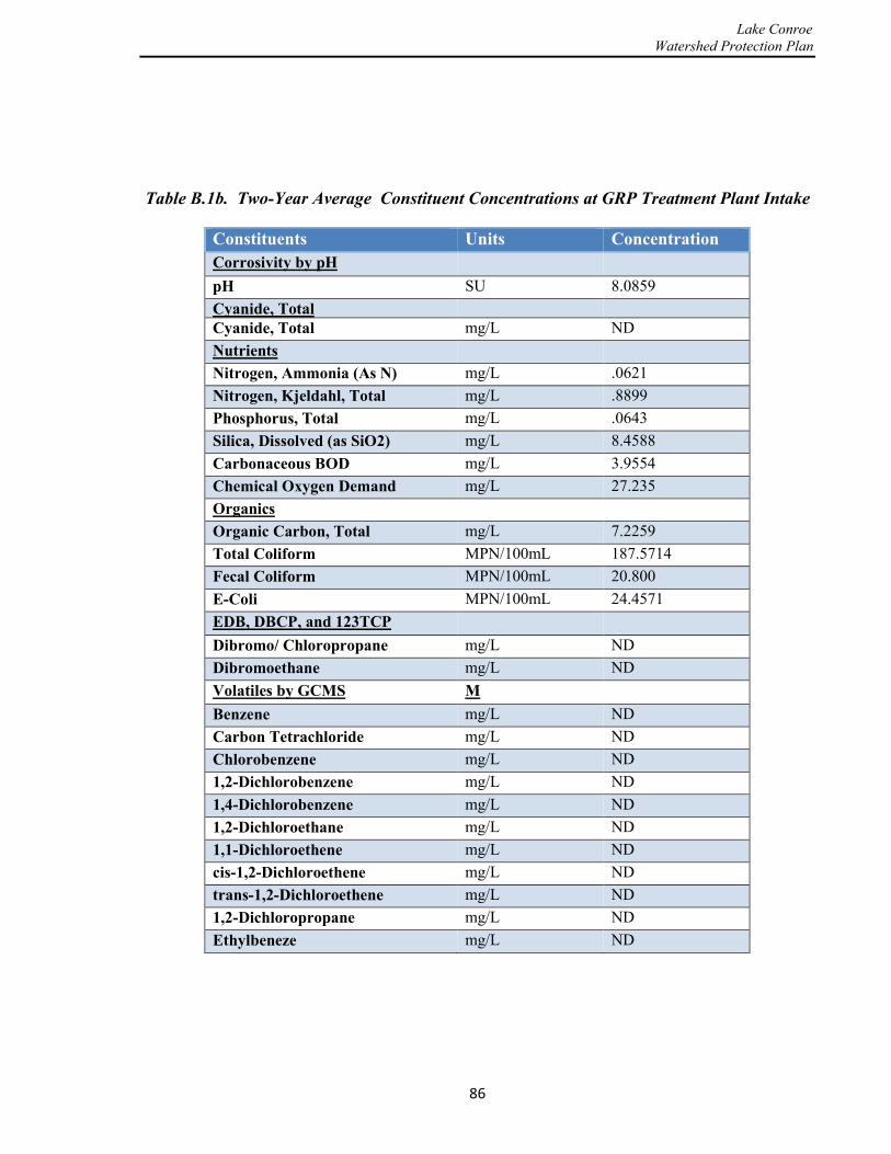
Lake Conroe Watershed Protection Plan
Table B.1b. Two-Year Average Constituent Concentrations at GRP Treatment Plant Intake
Constituents Units Concentration Corrosivity by pH pH SU 8.0859 Cyanide, Total Cyanide, Total mg/L ND Nutrients Nitrogen, Ammonia (As N) mg/L .0621 Nitrogen, Kjeldahl, Total mg/L .8899 Phosphorus, Total mg/L .0643 Silica, Dissolved (as SiO2) mg/L 8.4588 Carbonaceous BOD mg/L 3.9554 Chemical Oxygen Demand mg/L 27.235 Organics Organic Carbon, Total mg/L 7.2259 Total Coliform MPN/100mL 187.5714 Fecal Coliform MPN/100mL 20.800 E-Coli MPN/100mL 24.4571 EDB, DBCP, and 123TCP Dibromo/ Chloropropane mg/L ND Dibromoethane mg/L ND Volatiles by GCMS M Benzene mg/L ND Carbon Tetrachloride mg/L ND Chlorobenzene mg/L ND 1,2-Dichlorobenzene mg/L ND 1,4-Dichlorobenzene mg/L ND 1,2-Dichloroethane mg/L ND 1,1-Dichloroethene mg/L ND cis-1,2-Dichloroethene mg/L ND trans-1,2-Dichloroethene mg/L ND 1,2-Dichloropropane mg/L ND Ethylbeneze mg/L ND
86

Lake Conroe Watershed Protection Plan
Table B.1c. Two-Year Average Constituent Concentrations at GRP Treatment Plant Intake
Constituents Units Concentration Methylene chloride (DCM) mg/L ND Styrene mg/L ND Tetrachloroethene mg/L .0006 Toluene mg/L ND 1,2,4-Trichlorobenzene mg/L ND 1,1,1-Trichlorethane mg/L ND 1,1,2-Trichloroethane mg/L ND Trichloroethene mg/L ND Vinyl chloide mg/L ND m,p-Xylene mg/L ND o-Xylene mg/L ND Xylene, Total mg/L ND Methyl tert-butyl ether (MTBE) mg/L ND Carbamates Carbofuran mg/L ND Oxamyl mg/L ND Herbicides, DW Dalapon mg/L ND
2,4-D mg/L ND 2,4,5-TP (Silvex) mg/L ND 2,4,5-T mg/L ND Dinoseb mg/L ND Picloram mg/L ND glyphosate mg/L ND Endothall mg/L ND Diquat mg/L ND
87

Lake Conroe Watershed Protection Plan
Table B.1d. Two-Year Average Constituent Concentrations at GRP Treatment Plant Intake
Constituents Units Concentration Organic Compounds Alachlor mg/L ND Atrazine mg/L .1315 Benzo(a)pyrene mg/L ND bis(2ethylhexyl)adipate mg/L ND Bis(2-ethylhexyl)phthalate mg/L .0034 Endrin mg/L ND gamma-BHC mg/L ND Heptachlor mg/L ND Heptachlor epoxide mg/L ND Hexachlorobenzene mg/L ND Hexachlorocyclopentadiene mg/L ND Methoxychlor mg/L ND Pentachlorophenol mg/L ND Simazine mg/L ND Chlorinated Pesticides Chlordane mg/L ND Toxaphene mg/L ND Aroclor 1016 mg/L ND Aroclor 1221 mg/L ND Aroclor 1232 mg/L ND Aroclor 1242 mg/L ND Aroclor 1248 mg/L ND Aroclor 1254 mg/L ND Aroclor 1260 mg/L ND Geosmine ng/L 38.5953 Methylisoborneol ng/L 15.7.57 MBAS (surfactants) mg/L ND Perchlorate pg/L 23.00 TCDD pg/L 23.4343
88
Lake Conroe Watershed Protection Plan
Appendix C
OSSF Regulation (Amendments to be considered)
A. The size of all lots utilizing OSSF’s and being served by a public water system must be at least one acre, and the size of all lots not served by a public water system must be at least one and one-half acre.
B. All new systems, and existing systems being modified, must be designed and submitted by a registered sanitarian or professional engineer.
C. All OSSF’s, regardless of the size of the property served, must meet all requirements of the Rules of the Authority and must be permitted by the Authority.
D. The maintenance of all OSSF’s identified in Title 30 Texas Administrative Code (TAC) 285.91 (12) must be performed by a TCEQ-licensed maintenance provider unless the OSSF serves a single-family dwelling that is the primary residence of the property owner and the property owner has completed the TCEQ Aerobic Treatment Unit Maintenance Provider Course.
E. The Authority may periodically inspect any OSSF at a frequency deemed appropriate by the Authority.
F. Connection to an organized disposal system (public sewer): No person may cause or allow the installation of a private sewage facility when any part of the facility is within a horizontal distance of 300 feet (measured on the closest practical access route) of an existing organized disposal system, with the exception of written denial of service from the owner or governing body of the organized disposal system.
G. All subsurface on-site sewage systems shall be designed with the usage rate in gallons per day without the 20-percent reduction for using water-saving devices.
H. Timed pump tanks will allow for a two-thirds day of flow in reserve. An override switch may be installed as long as it is positioned above the high-water alarm to activate after the reserve storage space has been used and prior to the tank completely filling.
I. All gravity-fed subsurface disposal fields must be close-looped and have an inspection port at the furthest point of the disposal area from the tank.
J. OSSF’s will not be installed in the regulatory floodway. Aerobic systems can be installed in the floodplain if components of the OSSF (risers, chlorinator, clean-outs, inspection ports, control panels, compressors) are elevated above base-floor elevation. Sprinklers shall be of the back-flow prevention type.
89
Lake Conroe Watershed Protection Plan
K. All domestic wastewater is to be properly treated prior to disposal; including grey water which is defined as: water emanating from showers, bathtubs, hand washing lavatories, sinks, and any other sanitary facilities.
L. Maintenance Inspections and Reports:
1. Any homeowner who is not contracted with a TCEQ-registered maintenance company to perform testing, reporting, and maintenance on as OSSF shall still be required to submit all required reports and testing required of a TCEQ-registered maintenance company to the Authority, along with any required fees or charges (fees for property owners may be different than those required of registered maintenance companies).
2. Inspections, at a minimum, must meet all inspection requirements as set by the TAC Chapter 285 and the Authority.
3. Inspection reports shall address all inspection and testing required by the SJRA policies and procedures of the State of Texas, including TAC 30 Chapter 285.
4. In addition to the information required by TAC 30 Chapter 285, all maintenance/inspection reports shall include:
a) The reporting of any unauthorized alterations to the system.
b) The condition of the spray area (if applicable).
c) The permit number.
d) OSSF or certified maintenance provider license identification.
e) The printed name and signature of the maintenance company representative or home owner if he or she is submitting the report.
f) The physical address of the OSSF system.
g) The physical address, business address, business phone number and emergency phone number of the maintenance company.
5. In addition to the information required by TAC 30 Chapter 285, all maintenance/inspection contracts shall include:
a) The permit number.
b) OSSF or wastewater maintenance provider license identification.
c) The printed name and signature of the maintenance company representative and homeowner/property owner.
d) The physical address of the OSSF location. 90
Lake Conroe Watershed Protection Plan
e) The physical address, business address, business phone number and
emergency phone number of the maintenance company.
M. On all new plats for residential subdivisions of two or more lots, easements for the proposed wells shall be established by plat unless an alternative strategy is developed in the feasibility study.
N. Revocation or suspension of license to operate: Neither the revocation of a license nor any other provision of these regulations shall impede the designated representative or any other governmental entity from taking the proper steps to prevent or curtail pollution, to abate a nuisance, or to protect public health. The designated representative may revoke or suspend a license for any of the following causes:
1. A change in the volume of wastewater being treated by the OSSF.
2. Failure of the holder of the license to properly maintain the OSSF.
3. Malfunction of the OSSF.
4. Evidence that the OSSF is causing or will cause pollution.
5. Failure to comply with the terms or conditions of the license or any part of these regulations.
O. Any single family dwelling, commercial or institutional facility, multi-unit residential development or recreational vehicle park occupied during any part of the day or night shall be connected to an OSSF or other approved method of wastewater treatment and/or disposal.
P. When a visual and audible alarm is required for an OSSF connected to a “Food Establishment,” an additional visual and audible alarm shall be located or installed inside the facility, located in an area conspicuous to view by employees or management. (For the purpose of this Order, a “Food Establishment “ is an operation that stores, prepares, packages, serves, or otherwise provides food for human consumption, such as: a restaurant; retail food store; satellite or catered feeding location; catering operation.)
Q. All “Food Establishments”, as defined above, which are receiving secondary treatment of the effluent shall be checked and maintained monthly by a contracted registered maintenance company. A chlorine residual or fecal coliform test shall be made at each site visit where disinfection is required. One biochemical oxygen demand and Total Suspended Solids (TSS) grab sample test shall be conducted per year. The minimum acceptable test results shall be those outlined by the applicable state rules. All test results and maintenance reports shall be sent to the Authority within 14 days after the test is performed. Additional testing and reporting may be required on a case-by-case basis.
91